Real-time GeoAI for High-resolution Mapping and Segmentation of Arctic Permafrost Features
Abstract.
This paper introduces a real-time GeoAI workflow for large-scale image analysis and the segmentation of Arctic permafrost features at a fine-granularity. Very high-resolution (0.5m) commercial imagery is used in this analysis. To achieve real-time prediction, our workflow employs a lightweight, deep learning-based instance segmentation model, SparseInst, which introduces and uses Instance Activation Maps to accurately locate the position of objects within the image scene. Experimental results show that the model can achieve better accuracy of prediction at a much faster inference speed than the popular Mask-RCNN model.
1. Introduction
Polar regions are one of Earth’s remaining frontiers that play a vital role in global climate, ecosystems, and economy. Global warming over the past century is driving dramatic change in the Arctic ecosystem, endangering its natural environment, infrastructure, and life of the indigenous population. Permafrost, ground that remains below 0°C for at least two consecutive summers, is at the center of this change. Covering nearly of the land in the northern hemisphere, thawing permafrost is causing significant local and regional impacts on the Arctic community. As the ice-rich frozen ground thaws, land subsides causing severe damage to buildings, roads, pipelines, and industrial infrastructure (Hjort et al., 2018). Permafrost degradation also increases rates of coastal erosion, wildfires, and flooding, which may further accelerate the thawing process and make the Arctic ecosystem even more vulnerable to climate change (Grosse et al., 2016). At a global scale, the thawing of Arctic permafrost will result in the release of an immense amount of carbon dioxide and methane, exaggerating the greenhouse effect and global warming through complex feedback mechanisms (Schuur et al., 2015).
To improve our understanding of permafrost dynamics and its linkages to other Arctic ecosystem components in the midst of rapid Arctic change, it is critically important to have spatial data readily available that provide fine-granularity mapping of permafrost features, their extent, distribution, and longitudinal changes. Achieving this goal requires new approaches that can perform automated mining from Arctic big data. It is exciting that the Arctic community has started to embrace GeoAI (Li, 2020; Li and Hsu, 2022) and big data to support Arctic research, from predicting Arctic sea ice concentration (Andersson et al., 2020), to finding marine mammals on ice (NOAA, 2019), creating Arctic land cover maps (Song et al., 2019), and automated mapping of permafrost features (Bhuiyan et al., 2020). Pioneering research in performing automated characterization of Arctic permafrost features has also been reported in the literature. An GeoAI-based Mapping Application for Permafrost Land Environment (MAPLE) is being developed to integrate Big Imagery, GeoAI, and High-Performance Computing (HPC) to achieve classification of permafrost features, in particular, ice-wedge polygons (IWP) (Udawalpola et al., 2022). The delineation of IWPs is achieved using a popular instance segmentation model, Mask R-CNN (He et al., 2017). Huang et al. (2022) applied a semantic segmentation model U-Net for mapping retrogressive thaw slumps, another important feature type of Arctic permafrost for understanding permafrost thaw and Arctic warming.
While these deep learning models, such as Mask R-CNN, result in satisfying performance in terms of prediction accuracy, they can hardly achieve real-time processing because the algorithms often require placement of a large number of candidate bounding boxes and complex post-processing to remove redundant information. To reduce computational cost and perform efficient permafrost mapping at the pan-Arctic scale (which covers over 5 million of tundra region), it is necessary to develop and apply new models that can achieve high-accuracy and real-time prediction. This paper aims to achieve this goal by integrating a novel real-time instance segmentation model, SparseInst (Cheng et al., 2022), in our automated permafrost feature mapping pipeline. The next section describes the methodological workflow in detail.
2. Method
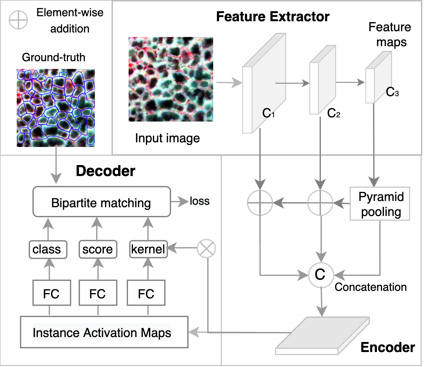
Figure 1 demonstrates the workflow of real-time GeoAI for Arctic permafrost mapping. We adopt a novel instance segmentation model SparseInst into the workflow, which contains three major components: a feature extractor, an instance context encoder, and an Instance Activation Map (IAM)-based decoder. The feature extractor is responsible for extracting multi-scale features from the input. The encoder will process the extracted features and fuse them into single-level features with multi-scale representations. The encoded features are then processed by the decoder to generate IAMs for instance classification and segmentation. Each component is designed under the consideration of lightweight architecture and low computational complexity to achieve fast inference speed.
2.1. Feature Extractor
The feature extractor adopted in this work is ResNet-50 (He et al., 2016). Among various deep neural network (DNN) architectures, ResNet-50 enjoys a good trade-off between accuracy and model complexity so to support real-time applications (Bianco et al., 2018). ResNet extracts representative features for objects of different types using a deep residual network. After a series of convolutional operations, multi-scale feature maps can be generated, among which high-resolution maps are better at small-object segmentation and low-resolution feature maps can better support segmentation of large objects. To accurately segment objects of varying sizes, hierarchical feature maps at multiple scales and resolutions are passed to the encoder (see Figure 1).
2.2. Instance Context Encoder
The main purpose of the encoder is to generate a single feature map containing multi-scale representations. Conventional approaches use multi-scale features with multi-level predictions (Li et al., 2019) for segmenting objects at different scales (Wang et al., 2020). However, this will increase overall processing time of the model, making it less efficient and less favorable for real-time applications. Recent real-time instance segmentation models (Perreault et al., 2021; Bolya et al., 2019) fuse multi-scale information into a single feature map to reduce both prediction and post-processing time. SparseInst utilizes a similar idea and it fuses three feature maps obtained from different convolution stages. The fusion first follows the feature pyramid network (FPN) (Lin et al., 2017) to use a top-down pathway for building semantic-rich features. To further enhance the scale information, the last feature map () also undergoes a pyramid pooling operation (Zhao et al., 2017) to increase the global contextual information without increasing the size of the feature maps. Next, all feature maps are upsampled to the same resolution and concatenated together to generate feature maps at a single resolution but with multi-scale representations. The output is then sent to the decoder for classification and segmentation.
2.3. IAM-based Decoder
The function of the decoder is to take the fused feature map from the encoder as input to generate predictions. Each prediction contains a triple ¡object class, objectness score, kernel¿. The objectness score refers to the probability of an object belonging to a certain class and the kernel is a low-dimensional representation of location information for that object. This instance-level prediction is achieved through the generation of Instance Activation Maps (IAMs) which are capable of highlighting important image areas. Different from conventional approaches which use dense anchors to detect and segment objects, SparseInst trains the decoder to create IAMs, which have a one-to-one mapping with the objects to segment. This design helps the decoder to achieve real-time performance as it avoids the time-consuming post-processing of some models, such as Mask R-CNN, which need to select from thousands of anchors to predict the most accurate mask and to perform matching between predicted masks and the ground-truth. Once the predictions are generated, they are sent to perform bipartite matching to associate each ground-truth object with its most similar prediction, then the difference between the prediction and the ground-truth is encoded into the loss function. As the model is being trained, it learns to generate more accurate IAMs and thus more accurate predictions, lowering the loss until the model fully converges.
3. Experiments and Results
3.1. Data
To assess the performance of the models, we created an AI-ready dataset containing 867 image tiles and a total of 34,931 ice-wedge polygons (IWPs). The dataset covers dominant tundra vegetation types in the polygonal landscapes, including sedge, tussock, and barren tundra. Very high resolution (0.5 m) remote sensing imagery acquired by Maxar sensors is used for annotation and model training. The average image size is with the largest image size . Each image has a label indicating the image size and coordinates of the IWPs.
The labeled images are divided into three sets: training (70%), validation (15%), and testing (15%). The maximum number of IWPs per image is 447. This statistic is critical in determining the maximum number of detections per image, as it is an important hyperparameter to set in the segmentation model. It also affects both accuracy and speed and provides a trade-off between them (Section 3.3).
| Model | FPS | AP50 | APS | APM | APL |
|---|---|---|---|---|---|
| Mask R-CNN | 27.01 | 52.86 | 33.28 | 60.03 | 64.39 |
| SparseInst | 45.61 | 53.97 | 31.70 | 60.78 | 68.10 |
3.2. Model Training and Results
In this work, we compare SparseInst with one of the most popular instance segmentation models, Mask R-CNN (He et al., 2017). Both models are built upon Detectron2 (Wu et al., 2019), a module of the PyTorch deep learning framework which provides state-of-the-art segmentation algorithms. The training is conducted on four NVIDIA A5000 GPUs. The batch size is 16 and the maximum number of iterations is 20,000. The maximum number of detections per image is set to 500. Table 1 shows the performance comparison between Mask R-CNN (default setting) and SparseInst. The evaluation metric for model inference speed is frame per second (FPS) and for accuracy, average precision (AP) (Zhang and Zhang, 2009) is used. As the results show, SparseInst demonstrates better performance in terms of both speed and accuracy than Mask R-CNN. We also separate IWPs into three groups by their areas: small (area ¡ 200 pixels), medium (area in between 200 and 450 pixels), and large (area ¿ 450 pixels). Table 1 also shows the average precision (AP) in each group. SparseInst performs slightly worse than Mask R-CNN on small IWPs segmentation, but it works better at segmenting medium- to large-size IWPs. Overall, SparseInst yields better detection accuracy than Mask R-CNN. Speed-wise, the model runs nearly twice as fast as Mask R-CNN, achieving real-time performance (model’s inference speed at 30 FPS or above).
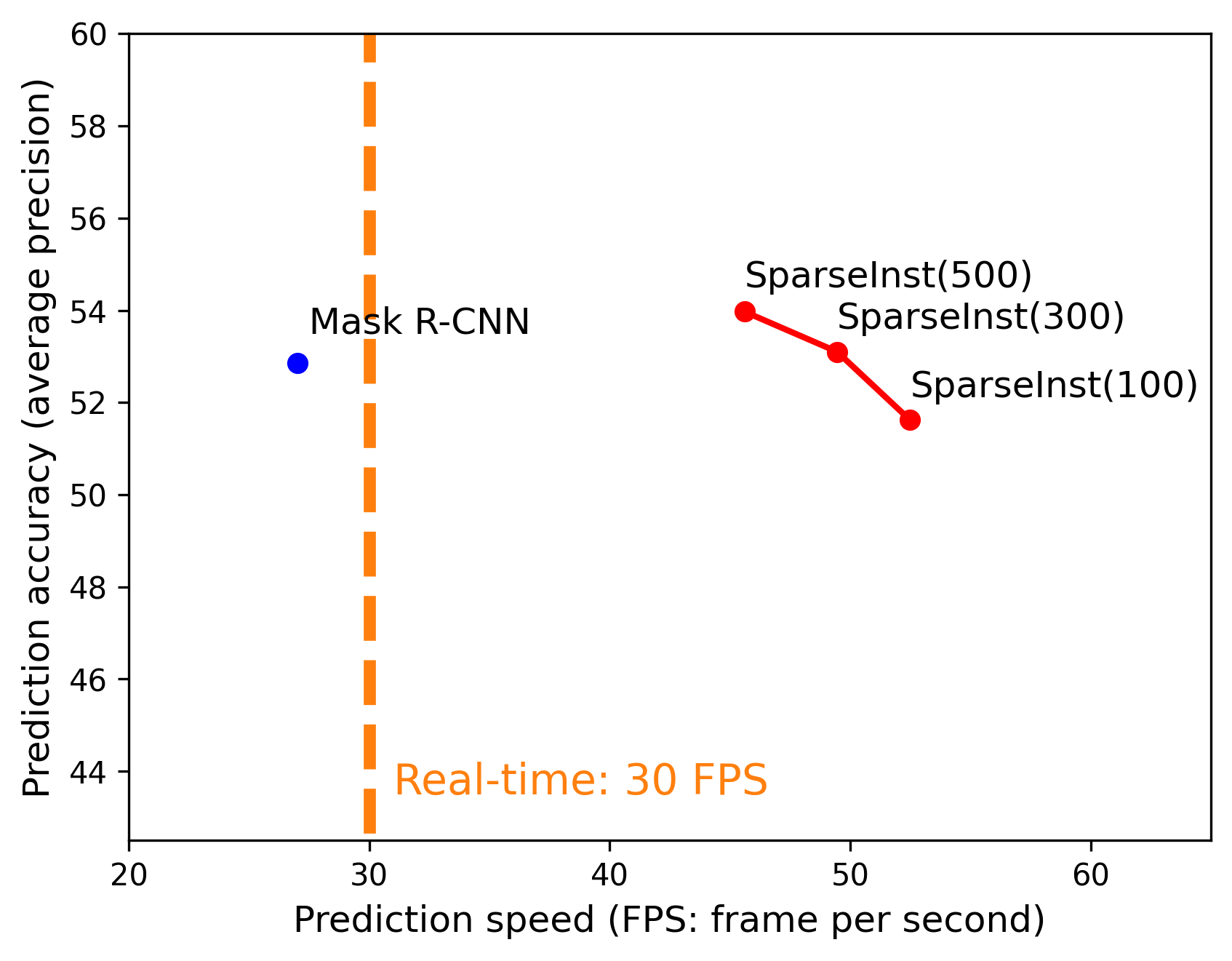
3.3. Precision vs. Speed
Figure 2 shows the precision and speed trade-off of the SparseInst model and its comparison with Mask R-CNN. We used the default setting of Mask R-CNN to conduct training and testing as it achieves better performance than other experimental settings. Differently, SparseInst requires a predefined to determine the maximum number of masks and predictions per image. This hyperparameter not only affects the model’s prediction accuracy but also its speed. A larger will slow down the process of bipartite matching during training and increase model complexity in the decoder part, therefore negatively affecting the model’s efficiency during both training and testing. Here, we tested the model performance at different settings of (at 100, 300 and 500 respectively). It can be seen that as decreases, the model’s prediction speed increases (x axis) but its predictive power (y axis) decreases (from 54% at =500 to 51% at =100). For Mask R-CNN, while its prediction accuracy is quite high, the speed is below the threshold of models that can be considered real-time. It is noteworthy that at both =500 and =300, SparseInst achieves better prediction accuracy than Mask R-CNN. This result verifies the importance of carefully setting values of hyperparameters according to data characteristics to achieve satisfying model performance.
3.4. Prediction Results
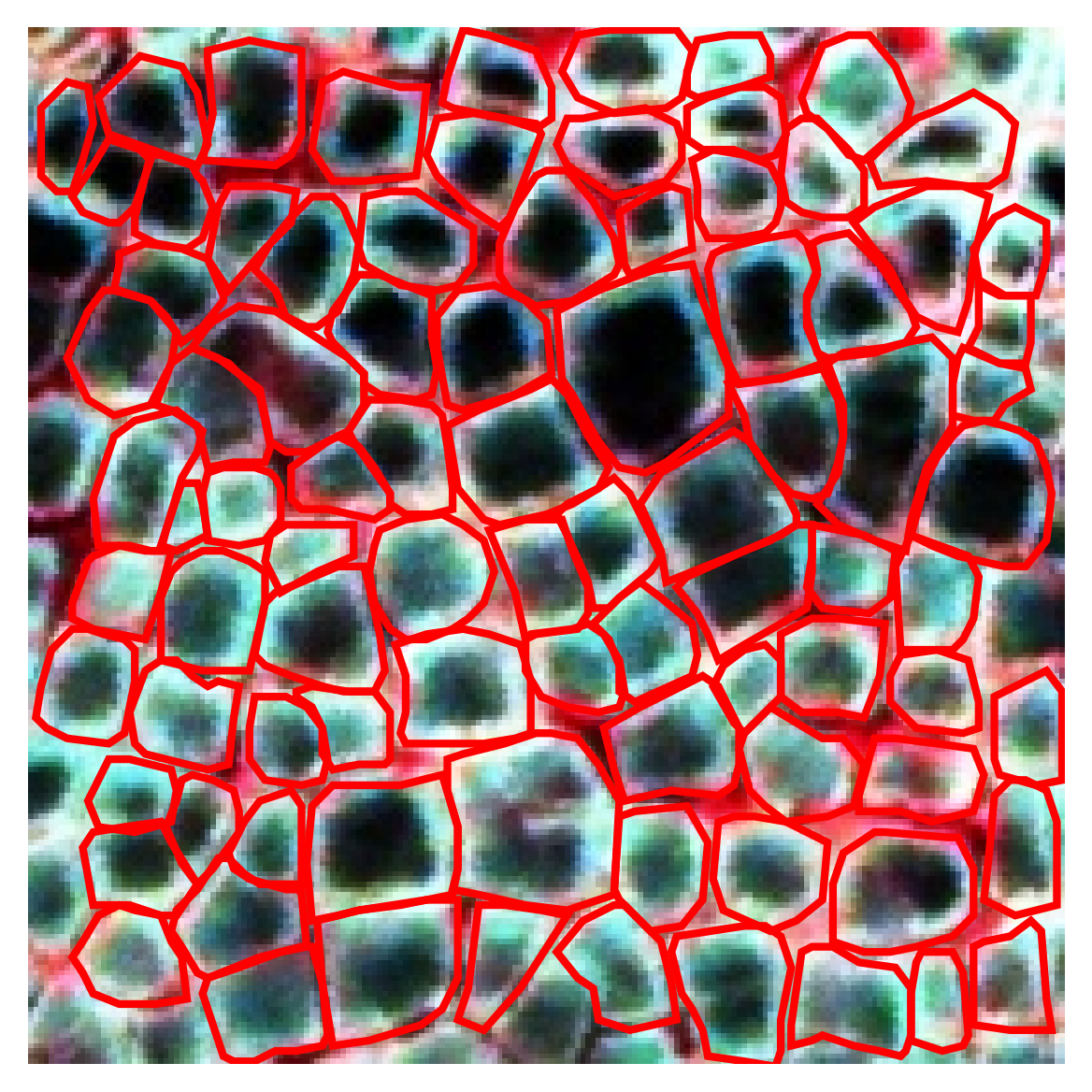
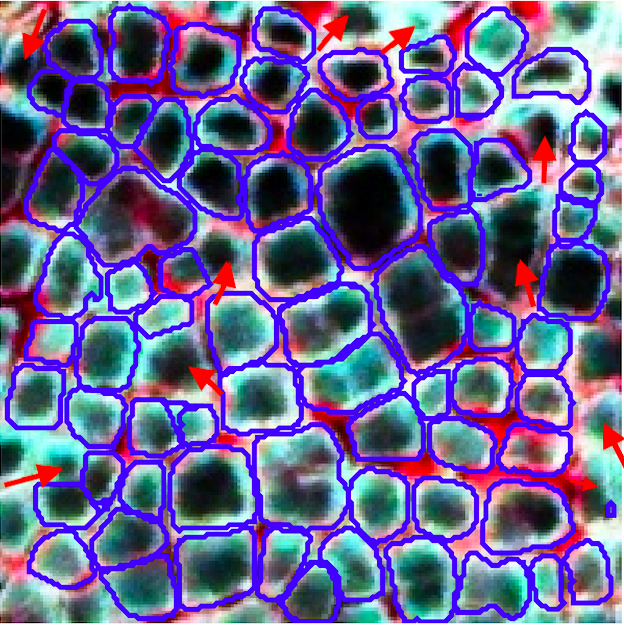
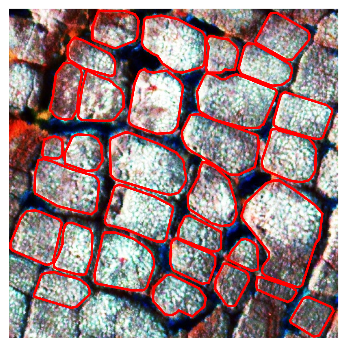
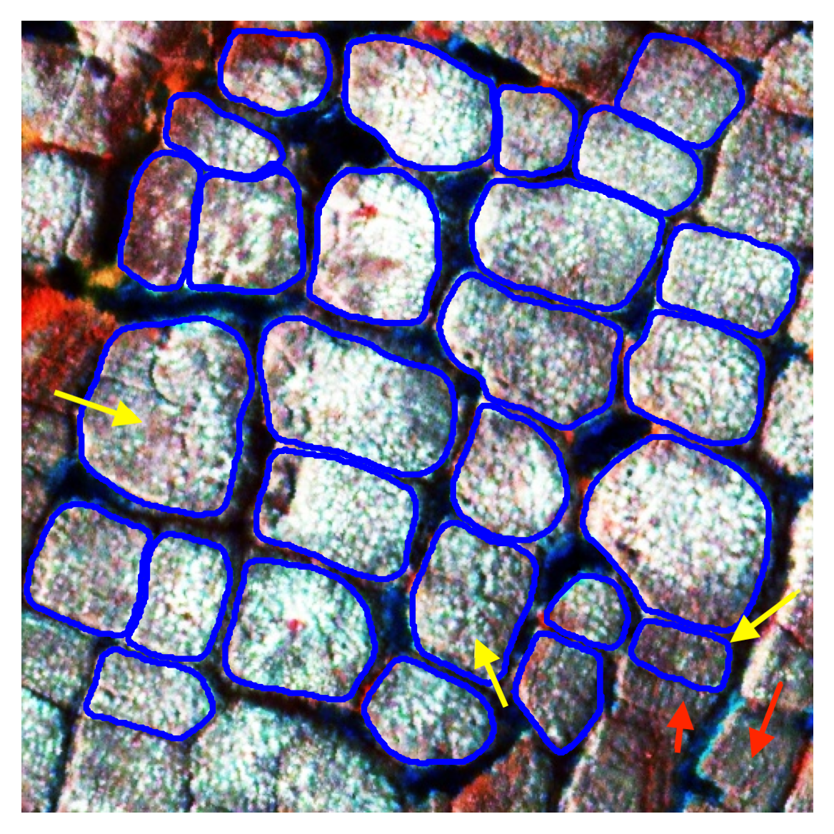
Figure 3 illustrates segmentation results for two sample images. Figure 3(a) and 3(c) provides the ground-truth labels of the IWPs. The ice-wedge polygons in these two images belong to two distinctive types of IWPs: low-centered (3(a), 3(b)) and high-centered (3(c), 3(d)). A preliminary analysis has also shown that when separating these feature types, thus making the segmentation task more challenging, the performance advantage of SparseInst over Mask R-CNN become even more dominant. This reflects the robustness of the SparseInst model in performing high-accuracy and real-time IWP segmentation.
Figure 3(b) and 3(d) present the model prediction results for the two images to their left (3(a) and 3(c)). It can be seen that for smaller objects, although the predicted area is quite close to the ground-truth, the boundary line itself is not as smooth as the human labels, 3(b). This issue does not exist in segmentation results for large objects, 3(d). The model did miss predictions for a few IWPs when there exist no clear boundaries around them (red arrows in 3(b) and 3(d)). There are also incorrect predictions (yellow arrows in 3(d)); this is likely due to the semantically different concepts that expert annotators and the machine consider. Interestingly, the model can predict labels for some partial IWP near the border where is not labeled by experts.
4. Conclusion
This paper introduces a real-time GeoAI workflow for segmenting an important permafrost feature, IWPs. Delineating their extent and qualifying their changes is critically important to understand Arctic warming and permafrost thaw and its impact to the Arctic environment, infrastructure, and people. Here, we adopt a light-weight instance segmentation model into the workflow and verify its good performance in terms of both prediction accuracy and speed. In the future, we will further improve both the training data to explicitly annotate multi-type IWPs, and also refine the model to improve its detection accuracy of small objects.
Acknowledgements.
This work is supported in part by the National Science Foundation under awards 2120943, 1853864, 1927872, and 2230034.References
- (1)
- Andersson et al. (2020) Tom Andersson, Fruzsina Agocs, Scott Hosking, María Pérez-Ortiz, Brooks Paige, Chris Russell, Andrew Elliott, Stephen Law, Jeremy Wilkinson, Yevgeny Askenov, et al. 2020. Deep learning for monthly Arctic sea ice concentration prediction. In EGU General Assembly Conference Abstracts. 15481.
- Bhuiyan et al. (2020) Md Abul Ehsan Bhuiyan, Chandi Witharana, and Anna K Liljedahl. 2020. Use of very high spatial resolution commercial satellite imagery and deep learning to automatically map ice-wedge polygons across tundra vegetation types. Journal of Imaging 6, 12 (2020), 137.
- Bianco et al. (2018) Simone Bianco, Remi Cadene, Luigi Celona, and Paolo Napoletano. 2018. Benchmark Analysis of Representative Deep Neural Network Architectures. IEEE access 6 (2018), 64270–64277.
- Bolya et al. (2019) Daniel Bolya, Chong Zhou, Fanyi Xiao, and Yong Jae Lee. 2019. Yolact: Real-time Instance Segmentation. In Proceedings of the IEEE/CVF International Conference on Computer Vision. 9157–9166.
- Cheng et al. (2022) Tianheng Cheng, Xinggang Wang, Shaoyu Chen, Wenqiang Zhang, Qian Zhang, Chang Huang, Zhaoxiang Zhang, and Wenyu Liu. 2022. Sparse Instance Activation for Real-Time Instance Segmentation. In Proceedings of the IEEE/CVF Conference on Computer Vision and Pattern Recognition. 4433–4442.
- Grosse et al. (2016) Guido Grosse, Scott Goetz, A Dave McGuire, Vladimir E Romanovsky, and Edward AG Schuur. 2016. Changing permafrost in a warming world and feedbacks to the Earth system. Environmental Research Letters 11, 4 (2016), 040201.
- He et al. (2017) Kaiming He, Georgia Gkioxari, Piotr Dollár, and Ross Girshick. 2017. Mask r-cnn. In Proceedings of the IEEE international conference on computer vision. 2961–2969.
- He et al. (2016) Kaiming He, Xiangyu Zhang, Shaoqing Ren, and Jian Sun. 2016. Deep Residual Learning for Image Recognition. In Proceedings of the IEEE Conference on Computer Vision and Pattern Recognition. 770–778.
- Hjort et al. (2018) Jan Hjort, Olli Karjalainen, Juha Aalto, Sebastian Westermann, Vladimir E Romanovsky, Frederick E Nelson, Bernd Etzelmüller, and Miska Luoto. 2018. Degrading permafrost puts Arctic infrastructure at risk by mid-century. Nature communications 9, 1 (2018), 1–9.
- Huang et al. (2022) Lingcao Huang, Trevor C Lantz, Robert H Fraser, Kristy F Tiampo, Michael J Willis, and Kevin Schaefer. 2022. Accuracy, Efficiency, and Transferability of a Deep Learning Model for Mapping Retrogressive Thaw Slumps across the Canadian Arctic. Remote Sensing 14, 12 (2022), 2747.
- Li (2020) Wenwen Li. 2020. GeoAI: Where machine learning and big data converge in GIScience. Journal of Spatial Information Science 20 (2020), 71–77.
- Li and Hsu (2022) Wenwen Li and Chia-Yu Hsu. 2022. GeoAI for Large-Scale Image Analysis and Machine Vision: Recent Progress of Artificial Intelligence in Geography. ISPRS International Journal of Geo-Information 11, 7 (2022), 385.
- Li et al. (2019) Yanghao Li, Yuntao Chen, Naiyan Wang, and Zhao-Xiang Zhang. 2019. Scale-Aware Trident Networks for Object Detection. In 2019 IEEE/CVF International Conference on Computer Vision (ICCV). IEEE, Seoul, Korea (South), 6053–6062. https://doi.org/10.1109/ICCV.2019.00615
- Lin et al. (2017) Tsung-Yi Lin, Piotr Dollár, Ross Girshick, Kaiming He, Bharath Hariharan, and Serge Belongie. 2017. Feature Pyramid Networks for Object Detection. In Proceedings of the IEEE Conference on Computer Vision and Pattern Recognition. 2117–2125.
- NOAA (2019) NOAA. 2019. Developing artificial intelligence to find ice seals and polar bears from the sky. https://www.fisheries.noaa.gov/feature-story/developing-artificial-intelligence-find-ice-seals-and-polar-bears-sky (2019).
- Perreault et al. (2021) Hughes Perreault, Guillaume-Alexandre Bilodeau, Nicolas Saunier, and Maguelonne Héritier. 2021. CenterPoly: Real-Time Instance Segmentation Using Bounding Polygons. arXiv:2108.08923 [cs] (Sept. 2021). arXiv:2108.08923 [cs]
- Schuur et al. (2015) Edward AG Schuur, A David McGuire, Christina Schädel, Guido Grosse, Jennifer W Harden, Daniel J Hayes, Gustaf Hugelius, Charles D Koven, Peter Kuhry, David M Lawrence, et al. 2015. Climate change and the permafrost carbon feedback. Nature 520, 7546 (2015), 171–179.
- Song et al. (2019) Hunsoo Song, Yonghyun Kim, and Yongil Kim. 2019. A patch-based light convolutional neural network for land-cover mapping using Landsat-8 images. Remote Sensing 11, 2 (2019), 114.
- Udawalpola et al. (2022) Mahendra R Udawalpola, Amit Hasan, Anna Liljedahl, Aiman Soliman, Jeffrey Terstriep, and Chandi Witharana. 2022. An Optimal GeoAI Workflow for Pan-Arctic Permafrost Feature Detection from High-Resolution Satellite Imagery. Photogrammetric Engineering & Remote Sensing 88, 3 (2022), 181–188.
- Wang et al. (2020) Xinlong Wang, Rufeng Zhang, Tao Kong, Lei Li, and Chunhua Shen. 2020. SOLOv2: Dynamic and Fast Instance Segmentation. In Advances in Neural Information Processing Systems, H. Larochelle, M. Ranzato, R. Hadsell, M. F. Balcan, and H. Lin (Eds.), Vol. 33. Curran Associates, Inc., 17721–17732.
- Wu et al. (2019) Yuxin Wu, Alexander Kirillov, Francisco Massa, Wan-Yen Lo, and Ross Girshick. 2019. Detectron2. https://github.com/facebookresearch/detectron2.
- Zhang and Zhang (2009) Ethan Zhang and Yi Zhang. 2009. Average Precision. Springer US, Boston, MA, 192–193. https://doi.org/10.1007/978-0-387-39940-9_482
- Zhao et al. (2017) Hengshuang Zhao, Jianping Shi, Xiaojuan Qi, Xiaogang Wang, and Jiaya Jia. 2017. Pyramid Scene Parsing Network. In Proceedings of the IEEE Conference on Computer Vision and Pattern Recognition. 2881–2890.