4D Millimeter-Wave Radar in Autonomous Driving: A Survey
Abstract
The 4D millimeter-wave (mmWave) radar, capable of measuring the range, azimuth, elevation, and velocity of targets, has attracted considerable interest in the autonomous driving community. This is attributed to its robustness in extreme environments and outstanding velocity and elevation measurement capabilities. However, despite the rapid development of research related to its sensing theory and application, there is a notable lack of surveys on the topic of 4D mmWave radar. To address this gap and foster future research in this area, this paper presents a comprehensive survey on the use of 4D mmWave radar in autonomous driving. Reviews on the theoretical background and progress of 4D mmWave radars are presented first, including the signal processing flow, resolution improvement ways, extrinsic calibration process, and point cloud generation methods. Then it introduces related datasets and application algorithms in autonomous driving perception and localization and mapping tasks. Finally, this paper concludes by predicting future trends in the field of 4D mmWave radar. To the best of our knowledge, this is the first survey specifically for the 4D mmWave radar.
I Introduction
Autonomous driving technology, which aims to provide safe, convenient and comfortable transportation experiences, is going through rapid development. To realize high-level autonomous driving, the capabilities of environment perception, localization, and mapping are crucial. Therefore, the sensors on autonomous vehicles, such as cameras, LiDARs, and radars, as well as their algorithms, are attracting increasing research interest.
Among the various sensors, mmWave radars, benefiting from their recognized advantages of small-size, low-cost, all-weather operation, velocity-measuring ability, and high range resolution, etc., [1] have always been widely used for autonomous driving. However, traditional mmWave radars, also known as 3D mmWave radars, exhibit weak performance in measuring the elevation of targets, and their data typically only includes range, azimuth, and velocity information. Additionally, 3D mmWave radars suffer from clutter, noise, and low resolution, particularly in the angular dimension, which further limits their applicability to complex perception tasks.
The recent advancement of multiple-input multiple-output (MIMO) antenna technology has improved elevation resolution, leading to the emergence of 4D mmWave radar. As the name suggests, 4D mmWave radar can measure four types of target information: range, azimuth, elevation, and velocity.
The 4D mmWave radar not only serves as an improved version of mmWave radar, but also introduces numerous significant research topics. The raw data size of 4D mmWave radars is much larger than that of traditional ones, which poses challenges in signal processing and data generation, not to mention the clutter and noise. The sparsity and noise of 4D mmWave radar point clouds generated in the existing signal processing flow are more severe than those of LiDAR point clouds, necessitating the careful design of perception, localization and mapping algorithms that account for the 4D mmWave radar’s inherent characteristic.
Researchers have conducted a number of surveys on the theory and application of mmWave radars. In recent years, Bilik et al. [2] review the challenges of mmWave radar in autonomous vehicles and its future trends. Venon et al. [3] comprehensively summarize the theory and existing perception algorithms of mmWave radar in autonomous driving, while Harlow et al. [4] focus on mmWave radar applications in robotics for their survey. It is evident that most reviews are centered on 3D mmWave radars.
Despite the revolutionary rise of the 4D mmWave radar and correlated algorithms, there have been few specialized surveys. To address this gap, this paper presents a thorough review of 4D mmWave radar in autonomous driving. The main contributions of this work can be summarized as follows:
-
•
To the best of our knowledge, this is the first survey concentrating on 4D mmWave radar in autonomous driving.
-
•
Given the uniqueness of the 4D mmWave radar, this survey specifically introduces its theoretical background and signal processing pipeline.
-
•
This paper provides an exhaustive survey of 4D mmWave radar application algorithms in autonomous driving, covering research on perception, localization and mapping.
The remainder of this paper is organized as follows: Section II introduces the basic theory of 4D mmWave radars, including the signal processing flow, data formats, and the methods for improving resolution. Section III outlines some extrinsic calibration algorithms. Section IV summarizes some learning-based methods for generating point clouds. Section V lists available 4D mmWave radar datasets for researchers’ convenience. Section VI reviews 4D mmWave radar perception applications, categorized into 4D-radar-only methods and multi-modal methods. 4D mmWave radar applications in localization and mapping are presented in Section VII by the sort of odometry, relocalization, and simultaneous localization and mapping (SLAM). Section VIII discusses future trends of 4D mmWave radar in autonomous driving, and Section IX draws the conclusion.
II Background of 4D mmWave Radars
For researchers focusing on autonomous driving, fundamental knowledge about 4D mmWave radars may often be somewhat overlooked. This section briefly reviews the basic theory and resolution-improving approaches of 4D mmWave radars as the foundation for the following sections.
II-A Signal Processing Flow
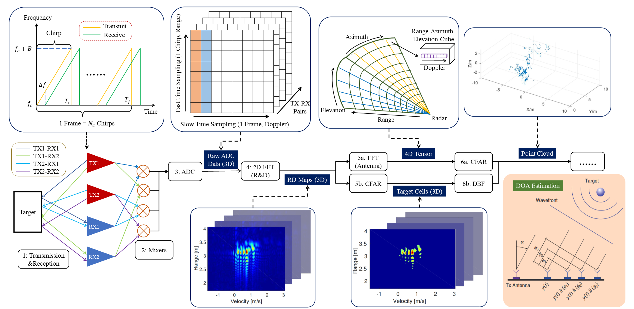
The traditional signal processing flow and corresponding data formats of 4D mmWave radars are shown in Fig.1. In step 1, millimeter waves are transmitted from transmission (TX) antennas. After reaching surrounding targets, waves are reflected to reception (RX) antennas. The waveform of most existing 4D mmWave radars is the Frequency Modulated Continuous Wave (FMCW), which offers superior resolution compared to other waveforms. In every working cycle (i.e. chirp) of the transmission antennas of FMCW radars, the frequency of the signal increases linearly with a starting frequency , a bandwidth , a frequency slope , and a time duration . By measuring the frequency of the received signal, the range of the target can be calculated as follows:
| (1) |
where is the time interval between transmission and reception, is the light speed, and is the frequency difference between the transmitted and received signals. Meanwhile, one frame of an FMCW radar contains chirps and has a time duration . To avoid interference between adjacent chirps, the transmitted and received signals are considered within one chirp, so the maximum unambiguous detection range of 4D mmWave radars is restricted by . Taking an AWR1843 from Texas Instrument as an instance, its , accordingly its maximum unambiguous range is 50m. Under the assumption that the range of a target in one frame is constant, the radial relative velocity of the target can be calculated by the Doppler effect as follows:
| (2) |
where the first equation is the Doppler effect formula, and are the frequency and phase drift between the received signals of adjacent two chirps, respectively. It is evident that the range and Doppler resolutions depend on , etc., for which readers can refer [3] for details.
To estimate the direction-of-arrival (DOA) of the target, a multiple-input multiple-output (MIMO) antenna design is typically applied in mmWave FMCW radars. The TX antennas and RX antennas consist of virtual TX-RX pairs. To separate transmit signals, different TX antennas should transmit orthogonal signals. By comparing the phase drift between different TX-RX pairs, distance differences between different pairs to the same target can be calculated. Further considering the positional relationship along TX and RX antennas, the DOA of the target can be obtained.
The signals of each pair are mixed by a mixer at step 2 and converted by an Analog-to-Digital Converter (ADC) at step 3 to obtain raw ADC data. It should be noted that the coordinates of the pair matrix in Fig. 1 represent sample timestamps within a chirp and a frame, respectively, and the value in each cell corresponds to reflection intensity. Then, at step 4, a 2D Fast Fourier Transformation (FFT) is conducted along the range and Doppler dimensions to generate the Range-Doppler map, the coordinates of which are range and velocity. Subsequently, there are two mainstream signal processing flows. The former one is to first conduct FFT along different TX-RX pairs to induce azimuth and elevation information (step 5a). acquiring a 4D range-azimuth-elevation-Doppler tensor, while for 3D mmWave radars, the result is a 3D range-azimuth-Doppler tensor. At step 6a, the constant false alarm rate (CFAR) algorithm [8] is usually applied in the four dimensions to filter the tensor by the intensity of every cell and obtain real targets in the format of point cloud for downstream tasks [9]. In contrast, the latter signal processing flow first filters RD maps to generate target cells using also CFAR algorithm (step 5b), then digital beamforming (DBF) method is employed at step 6b to restore angular information and generate a radar point cloud [6].
II-B Methods to Improve Resolution
As mentioned above, the most crucial ability of 4D mmWave radars is to measure the elevation of targets, which is equal to improving the elevation resolution. Specific methods can be divided into hardware and software levels as follows:
II-B1 Hardware
At the hardware level, increasing the number of TX-RX pairs or the aperture of antennas are two primary ways to improve resolution, including:
-
•
Cascading: simply cascading several standard mmWave radar chips [10] can increase TX-RX pairs, thus improving angular resolution. For instance, a 12TX-16RX (192 pairs) 4D mmWave radar can be formed by cascading four standard 3TX-4RX (12 pairs) radar chips. It is the most straightforward approach, but the size and power dissipation are also increased.
-
•
Chip integration: integrating more antennas on a chip is another promising technique [11]. It has the potential to replace cascading, but the disturbance between antennas remains an unsolved problem.
-
•
Meta-material: apertures constructed by meta-material can significantly increase the angular resolution while controlling the size [12], but such methods have not been mature enough to be widely applied.
II-B2 Software
By virtually realizing hardware improvement or optimizing signal processing algorithms along the processing flow, radar resolution can be improved at the software level.
-
•
Virtual aperture imaging: inspired by the traditional synthetic aperture radar (SAR), some researchers try to virtually expand the aperture of antennas through software design, thus enhancing the angular resolution [13]. This method has a remarkable effect on angular resolution improvement but usually needs the help of cascading to reduce noise.
- •
III Extrinsic Calibration
Radar point clouds are relatively sparse, and spectrum data is not sufficiently intuitive. Due to multi-path effects and clutter interference, noise is also considerable, posing challenges for calibration. For 4D mmWave radar, the higher resolution alleviates this issue, but there is still a lack of sufficiently robust online calibration methods.
Following traditional calibration methods of 3D mmWave radars, retro-reflectors are commonly used to improve calibration accuracy. By carefully placing several retro-reflectors in specific locations, analyzing sensing results of the 4D mmWave radar, and comparing them with LiDAR and camera data, the extrinsic parameters can be calibrated [16]. Instead of successively calibrating each sensor pair, Domhof et al. calibrate all sensors together directly with respect to the mobile robot’s body and achieve a median rotation error of only 0.02 ∘ [17].
However, the practicability of retro-reflectors in real scenarios is limited. In recent years, some researchers have designed calibration methods for 4D mmWave radars that do not require specially placed retro-reflectors. Instead, radar motion measurement is utilized to conduct calibration for radars [18] or radar-camera pairs [19]. The convenience of these methods is guaranteed, but verification in extreme weather conditions still needs to be implemented.
IV Learning-based Radar Point Cloud Generation
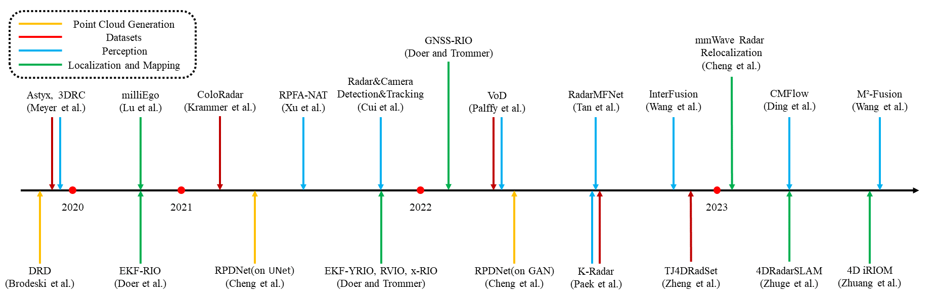
One primary reason for the sparsity of 4D radar point clouds is the substantial information loss caused by CFAR. To address this problem, an increasing number of learning-based methods have been proposed to replace CFAR, and work directly with RD maps or the 4D tensor to improve the quality of 4D radar point clouds and the performance of downstream autonomous driving tasks, such as perception and localization. Related works, as well as datasets, perception, localization and mapping algorithms of 4D mmWave radars that will be illustrated in the following, are uniformly shown on a timeline in Fig. 2.
Generally, CFAR is an optimal detection algorithm if cells are independent and identically distributed. However, as the targets in the real world usually have different shapes and occupy multiple cells, the CFAR-type methods will lead to masking effects, reducing the resolution of point clouds and suffering from information loss.
Brodeski et al. [20] first apply CNN to RD maps for detection and localization of multiple objects, which is called DRD(deep radar detection) net. They formulate the target detection in RD maps as a segmentation task and adopt a model structure similar to 2D-U-Net[21]. Facing the lack of well-annotated datasets, specifically for radar RD maps, they refer to the radar calibration process, arrange retro-reflectors in an anechoic chamber to collect corresponding data, and map them back to RD maps as labels. Experiments show that DRD net can operate in real-time (20ms for inference) and outperform classic methods in detection accuracy.
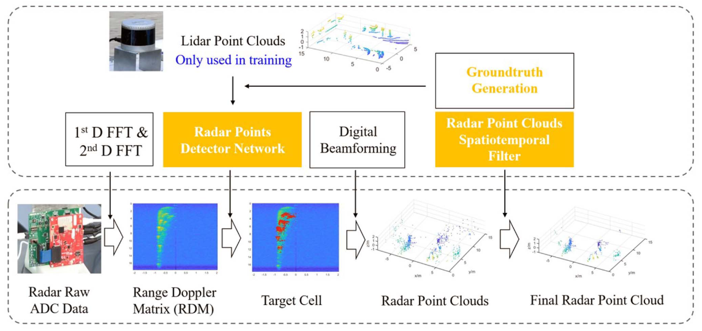
However, the labeling challenge for RD maps still exists since the data collected in the anechoic chamber differ from those collected in the real-world driving scene, which is more challenging with the multi-path reflections, interference, attenuation, etc. To address this challenge, Cheng et al. [6][22] use LiDAR point clouds as the supervision and successively design network structures based on U-Net[23] and GAN[24]. In complex roadway scenes, the generated 4D radar point clouds by [22] not only contain fewer clutter points but also provide denser point clouds of real targets compared to the classical CFAR detectors.
V Datasets
Currently, available datasets with 4D mmWave radars are introduced in this section, which are summarized in Table I.
-
•
∗ADC: raw ADC data; RT: radar tensor; RPC: radar point cloud;
-
•
∗∗Coloradar is a dataset for radar odometry, containing 2 hours of data without bounding box labels.
Public datasets are crucial for 4D mmWave radar-based algorithms as they provide a platform for developing and comparing different algorithms and stimulate related research. Therefore, we curated published datasets up to the time of writing hoping these datasets will facilitate the research of 4D radar-based algorithms.
Public 4D Radar data are fairly rare, Astyx HiRes 2019 is the first existing dataset [25]. The data provided for free consist of 500 synchronized frames (radar, LiDAR, camera) containing about 3,000 precisely annotated 3D object annotations. It can be seen that the amount of data in this dataset is relatively small.
ColoRadar is a dataset dedicated to research on localization and mapping, containing approximately 2 hours of data from radar, LiDAR, and the pose groundtruth[9]. It provides three levels of processing for radar data: raw ADC data, 3D range-azimuth-elevation tensors derived by compressing the Doppler dimension of 4D radar tensors, and radar point clouds. This dataset collects data in several unique environments, both indoors and outdoors, providing a diverse range of sensor data.
The VoD dataset is a new multi-sensor automotive dataset for multi-class 3D object detection, which consists of calibrated and synchronized LiDAR, camera, and radar data[26]. It contains 8693 frames of data acquired in complex urban traffic which consists of 123106 3D bounding box annotations of both moving and static objects and tracking IDs for each annotated object which is useful for tracking. Similarly, the Tj4DRadSet dataset contains 44 consecutive sequences with a total of 7757 synchronized frames, well-labeled using 3D bounding boxes and trajectory IDs [16]. Furthermore, it covers much richer and more challenging driving scenario clips (e.g. Urban roads, highways, industrial parks).
To the best of our knowledge, K-Radar is currently the largest large-scale dataset based on 4D mmWave radar and collects 35k frame conditions (e.g. sunny, foggy, rainy, snowy) [27]. In addition to 4D radar data, K-Radar provides high-resolution LiDAR point clouds, surround RGB images from four stereo cameras, and RTK-GPS and IMU data from the ego vehicle. It is worth mentioning that K-radar is currently the only dataset that provides 4D radar tensors. In order to facilitate experiments on various neural network structures, K-radar also provides a visual program to modularize the neural network training code.
Although 4D mmWave radar is receiving more and more attention from the academic community, and more and more datasets have been released, compared with vision or LiDAR, the amount of data is still not large enough.
VI Perception Applications
Currently, the point cloud density of 4D mmWave radar has already reached a level comparable to that of low-beam LiDAR, and 4D mmWave radar exhibits superior robustness under low visibility and adverse weather conditions. Therefore, researchers have been attempting to transfer LiDAR point cloud processing models to 4D mmWave radar for target detection, scene flow prediction, and other tasks. Furthermore, as described in Section IV, pre-CFAR radar data contain richer information, promoting some researchers to work directly with RD maps or 4D tensors, bypassing point cloud generation tasks.
Related work can be further divided into those relying solely on 4D radar or on multi-modal sensor fusion.
VI-A 4D-Radar-only Methods
Naturally, most related 4D-radar-only methods are derived from LiDAR-based methods. However, due to the sparsity and noise characteristics of mmWave radar, specific network designs are still required.
VI-A1 3D detection
As for the 3D object detection task, according to the difference between model architectures, perception methods can be divided into CNN-based and Transformer-based.
Palffy et al. [26] first apply PointPillars to 4D radar point clouds for 3D detection of multi-class road users. The performance is improved by temporal integration and by introducing additional features, such as elevation and Doppler velocity. However, the result of the proposed method (mAP 47.0) is still far inferior to the LiDAR detector on 64-beam LiDAR (mAP 62.1).
RPFA-Net [28] achieves progress by introducing a radar pillar features attention (PFA) module. It utilizes self-attention instead of the simplified PointNet [29] to extract the global context feature from pillars, which aims to effectively capture the information over a long distance and improve heading angle estimation accuracy.
As set operators, attention-based Transformer has inherent superiority in processing these point sets, which have permutation invariance. Therefore, to cope with sparse and noisy data of 4D mmWave radar, Tan et al. [30] propose a 3D object-detection framework based on multi-frame point clouds. They obtain the ego vehicle velocity and compensated velocity information from point clouds first, then accumulate nearby frames to the last frame.
In addition to directly processing perception tasks on radar point clouds, some studies have turned their attention to RD maps or 4D tensors, aiming to utilize more underlying hidden information. K-Radar dataset[27] proposes a 3D object detection baseline that directly consumes 4D tensors as input and verifies that the elevation information of 4D tensor is essential for 3D object detection. The proposed model also demonstrates the robustness of 4D tensor-based perception, especially under adverse weather conditions.
VI-A2 Scene flow estimation
Scene flow estimation aims to calculate a 3D motion vector field that represents the motion of both static and dynamic elements within the environment concerning the ego agent. While several research has traditionally relied on different sensing modalities such as cameras or LiDAR for scene flow estimation, there are also approaches that utilize 4D mmWave radar data to accomplish this task.
Representatively, Ding et al. [31] propose a novel approach to 4D radar-based scene flow estimation via cross-modal learning, motivated by the co-located sensing redundancy in modern autonomous vehicles. Such redundancy implicitly provides various forms of supervision cues to the radar scene flow estimation, which can effectively solve the difficulty in labeling radar point clouds. Specifically, this work introduces a multitask model architecture for the cross-modal learning problem. Extensive experiments show the state-of-the-art performance of this method and demonstrate the effectiveness of cross-modal supervised learning to infer more accurate 4D mmWave radar scene flow.
VI-B Fusion Methods
Considering that 4D mmWave radar can already provide point cloud information, some scholars have fused it with the camera or LiDAR for target detection, hoping to improve the accuracy and robustness of the perception model. Generally, there are three fusion levels for different modalities: data level, feature level, and decision level. Existing research primarily focuses on feature-level fusion.
As for 4DRV (4D Radar and Vision) fusion, 4D mmWave radar can provide high-precision depth and velocity information in a low-cost way, compensating for the shortcomings of cameras and thereby improving the accuracy of 3D detection. In recent studies, 4D mmWave radar signals are usually transformed into 2D image-like features so that they can be practically deployed together with camera images.
Representatively, Meyer et al. [32] apply a network based on [33] to the fusion of 4D mmWave radar and camera, which is originally developed for camera-LiDAR fusion. In order to make up for the data format difference, they discard the Doppler information and only retain the position information and the reflection intensity of 4D mmWave radar point clouds. The point clouds of each frame are used to generate a BEV image and then 3D proposals. Surprisingly, the precision of the fusion network is higher when radar data is used instead of LiDAR, and it reaches an average precision of 61% AP on Astyx dataset[25]. The authors argue that the reason may be the LiDAR sensor has only 16 beams, but further studies are still required.
A subsequent study is performed by Cui et al.[34] with a newly added self-supervised model adaptation block[35], which dynamically adapts the fusion of different modalities according to the object properties. Besides, a front view map is generated from the radar point clouds together with the BEV image. The presented method outperforms the former study[32] by up to 9.5% in 3D AP. The front view map can make better use of the elevation information provided by the 4D mmWave radar, and it is easier to fuse with the monocular camera feature, balancing between detection accuracy and computational efficiency.
Despite the above advantages of 4DRV fusion, the visual-based branch may still struggle to work facing aggressive lighting changes or adverse weather conditions, which in turn affects the overall performance of the model. Thus, Wang et al.[36] first explore the advantages of 4DRL(4D Radar and LiDAR) fusion with InterFusion, an interaction-based fusion framework. They design an InterRAL module(Interaction of Radar and LiDAR) and update pillars from two modalities to enhance feature expression. Ablation experiments are carried out to prove its effectiveness.
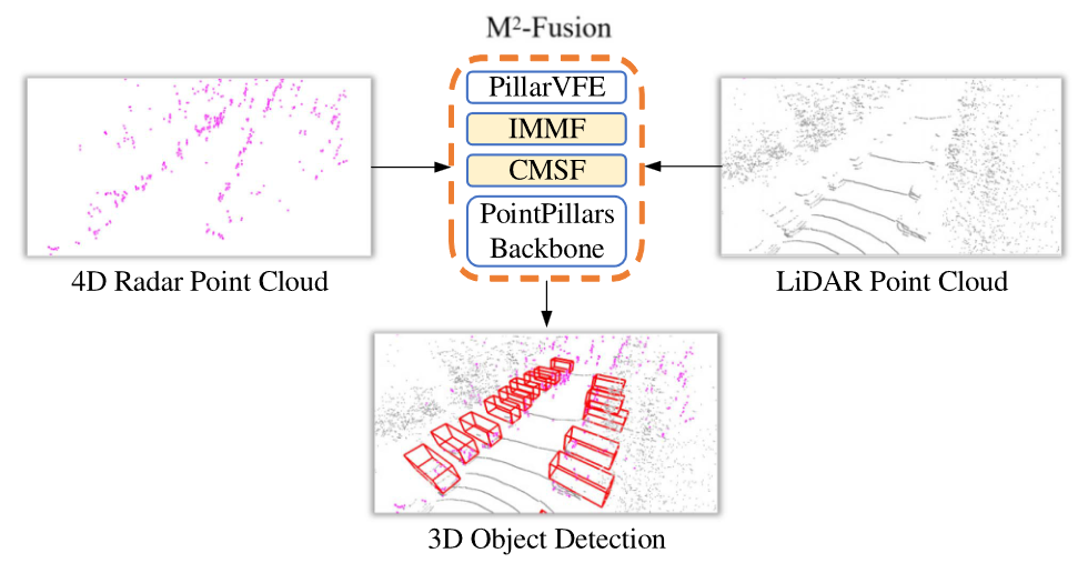
In a following study, Wang et al. [37] propose -Fusion network that integrates an interaction-based multi-modal fusion method termed IMMF and a center-based multi-scale fusion method termed CMSF. Evaluated using the Astyx dataset[25], it outperforms mainstream LiDAR-based object detection methods significantly. As LiDAR can accurately detect objects at close range, 4D mmWave radar has a far detection range due to its penetrability, so 4DRL fusion has the potential to be a reliable technical solution with low cost and high quality.
VII Localization and Mapping Applications
In severe environments where satellite positioning information is inaccurate, or high-definition maps are unavailable, localization and mapping by perception sensors are necessary. Some relevant research is carried out using the emerging 4D mmWave radar. As the radar point clouds is much lighter than the tensor, and studies for LiDAR can be transferred to it with minor adjustments, there is hardly any research on radar tensors about localization and mapping.
VII-A Odometry
Radar odometry estimation is the core of localization, and is also a key component of SLAM. There is quite a few related research on 4D mmWave radars. However, due to the sparsity and noise of radars, odometry is mostly generated with the help of the Inertial Measurement Unit (IMU).
Doer and Trommer make plenty of contributions to this topic using an Unmanned Aerial Vehicle (UAV). In [38], they estimate the height of the UAV by the barometer, then utilize a Random Sample and Consensus (RANSAC) based Least Squares to estimate ego velocity leveraging the Doppler information of the radar point clouds. The IMU data are fused finally to construct Extended Kalman Filter (EKF) based radar inertial odometry. On this basis, they consider Manhattan world assumptions, which assume planes in the environment are orthogonal to each other, and achieve comparable accuracy as the state-of-the-art visual-inertial odometry [39]. This contribution is then extended to multiple radars and shows satisfactory performance under degraded visual conditions with very little computational resource requirement[40] [41]. Besides, they also research the fusion of 4D mmWave radars with visual and thermal information to further enhance the result [42]. The only downside of these researches is that the EKF-based algorithm may face difficulty coping with large-scale environments since the odometry drift will increase. And in most works, Manhattan world assumptions may restrict the applicability in severe outdoor environments.
The EKF framework is also applied by Michalczyk et al. [43]. Instead of directly fusing IMU with ego velocity estimated by radar point clouds, they realize 3D point matching across sparse, noisy radar scans to measure the displacement between radar scans. The estimation of the 3D trajectory of the UAV reaches a 3.32% drift at the end of the total traveled distance.
Learning-based radar odometry estimation is also explored. Lu et al. [44] extract the features of radar point clouds and IMU by CNN and RNN encoders, respectively. Then a two-stage cross-modal attention layer is designed to fuse these features, and an RNN is used to model the long-term dynamics. The output of the whole network is the 6-DOF odometry, which achieves a 0.8m Absolute Trajectory Error (ATE). The performance demonstrates further upgrades with assistance from the RGB camera or depth camera.
VII-B Relocalization
Relocalization depends on high-accuracy online mapping, and is significant when using high-definition maps or detecting loop closure in SLAM. Considering the sparsity and noisiness of 4D mmWave radar point clouds, Cheng et al. [45] make use of Doppler velocity to remove moving objects, and then enhance the point clouds by merging multiple consecutive scans. Inspired by the famous PointNet, A multi‐layer perception (MLP) based network is employed to increase the dimension of each point from 4 to 1024 for pointwise feature extraction. By comparing extracted features of the current scan and the global map, relocalization can be realized.
VII-C SLAM
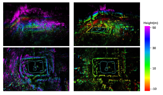
Since the above odometry and relocalization are indispensable for SLAM, research on 4D mmWave radar SLAM has emerged quite recently. Zhuang et al. [46] develop a whole-process SLAM for 4D mmWave radar point clouds based on iterative EKF. To avoid the sparsity caused by RANSAC-like methods, they conduct ego-velocity estimation by an iterative reweighted least squares. The weight of each radar point also reflects its dynamics, thus can help remove moving objects. The unconventional distribution-to-distribution matching between scan and submap further decreases the influence of sparsity. The effects are shown in Fig. 5.
VIII Future Trends
The 4D mmWave radar has the potential to bring about profound changes to autonomous vehicles. Nonetheless, it is far from mature at the moment. The future trends of 4D mmWave radar may rely mainly on the following areas.
VIII-1 Point cloud enhancement
As the most commonly used data format, 4D mmWave radar point clouds undergo evident low quality compared with other sensors. The data quality of point cloud is severely impacted by the characteristic of radars, such as the multi-path effect. Furthermore, there is an urgent need to refine the information loss during the signal processing flow, particularly by replacing CFAR with precisely designed learning-based methods. Learning-based methods for DOA estimation, instead of DBF methods, can also be explored for super-resolution angle estimation.
VIII-2 Application algorithms redesign
In addition to improving 4D mmWave radar point clouds, the application algorithms after signal processing is another non-neglectable issue. Up till now, a number of application algorithms for 4D mmWave radars are modified from corresponding LiDAR algorithms. The specialty of 4D mmWave radars, such as velocity measuring ability and adaptive capability in extreme environments should be further explored by future research. For perception tasks, multi-modal fusion is undoubtedly the future development direction. However, it remains to be explored whether the robustness of 4D radar in extreme weather conditions will be weakened by the integration of other sensor branches. For 4D mmWave radar localization and mapping, the sensor fusion with LiDARs and cameras has a great deal of room for discovery.
VIII-3 Pre-point cloud data utilizing
As for the unique data formats along the 4D mmWave radar signal processing flow, such as raw ADC data, RD maps, and 4D tensors, utilizing these data to perform perception, localization and mapping is an interesting but almost untouched topic. Learning-based models that take advantage of ample information from these data while keeping acceptable real-time performance may be a research hot spot.
VIII-4 Dataset enriching
Same as all other data-driven research areas, the datasets of 4D mmWave radars play a significant role in correlating studies. Existing datasets containing 4D mmWave radars are relatively rare. Data formats and scenario richness are two main fields waiting for expansion.
IX Conclusion
This paper offers a comprehensive overview of 4D mmWave radar in autonomous driving. It successively covers the signal processing theory, datasets, extrinsic calibration methods, learning-based radar point cloud generation algorithms, applications in perception, localization and mapping, as well as future trends. Research on 4D mmWave radars in the field of autonomous driving is still in progress and holds great potential for future advancements.
References
- [1] M. Jiang, G. Xu, H. Pei, Z. Feng, S. Ma, H. Zhang, and W. Hong, “4d high-resolution imagery of point clouds for automotive mmwave radar,” IEEE Transactions on Intelligent Transportation Systems, pp. 1–15, 2023.
- [2] I. Bilik, O. Longman, S. Villeval, and J. Tabrikian, “The rise of radar for autonomous vehicles: Signal processing solutions and future research directions,” IEEE Signal Processing Magazine, vol. 36, no. 5, pp. 20–31, Sep. 2019.
- [3] A. Venon, Y. Dupuis, P. Vasseur, and P. Merriaux, “Millimeter wave fmcw radars for perception, recognition and localization in automotive applications: A survey,” IEEE Transactions on Intelligent Vehicles, vol. 7, no. 3, pp. 533–555, Sep. 2022.
- [4] K. Harlow, H. Jang, T. D. Barfoot, A. Kim, and C. Heckman, “A new wave in robotics: Survey on recent mmwave radar applications in robotics,” May 2023.
- [5] S. Abdulatif, Q. Wei, F. Aziz, B. Kleiner, and U. Schneider, “Micro-doppler based human-robot classification using ensemble and deep learning approaches,” in 2018 IEEE Radar Conference (RadarConf18), Apr. 2018, pp. 1043–1048.
- [6] Y. Cheng, J. Su, H. Chen, and Y. Liu, “A new automotive radar 4d point clouds detector by using deep learning,” in ICASSP 2021 - 2021 IEEE International Conference on Acoustics, Speech and Signal Processing (ICASSP), Jun. 2021, pp. 8398–8402.
- [7] G. Hakobyan and B. Yang, “High-performance automotive radar: A review of signal processing algorithms and modulation schemes,” IEEE Signal Processing Magazine, vol. 36, no. 5, pp. 32–44, Sep. 2019.
- [8] H. Rohling, “Radar cfar thresholding in clutter and multiple target situations,” IEEE Transactions on Aerospace and Electronic Systems, vol. AES-19, no. 4, pp. 608–621, Jul. 1983.
- [9] A. Kramer, K. Harlow, C. Williams, and C. Heckman, “Coloradar: The direct 3d millimeter wave radar dataset,” The International Journal of Robotics Research, vol. 41, no. 4, pp. 351–360, Apr. 2022.
- [10] A. Och, C. Pfeffer, J. Schrattenecker, S. Schuster, and R. Weigel, “A scalable 77 ghz massive mimo fmcw radar by cascading fully-integrated transceivers,” in 2018 Asia-Pacific Microwave Conference (APMC), Nov. 2018, pp. 1235–1237.
- [11] P. Ritter, M. Geyer, T. Gloekler, X. Gai, T. Schwarzenberger, G. Tretter, Y. Yu, and G. Vogel, “A fully integrated 78 ghz automotive radar system-an-chip in 22nm fd-soi cmos,” in 2020 17th European Radar Conference (EuRAD), Jan. 2021, pp. 57–60.
- [12] J. Jiang, Y. Li, L. Zhao, and X. Liu, “Wideband mimo directional antenna array with a simple meta-material decoupling structure for x-band applications,” The Applied Computational Electromagnetics Society Journal (ACES), pp. 556–566, May 2020.
- [13] Z. Wu, L. Zhang, and H. Liu, “Generalized three-dimensional imaging algorithms for synthetic aperture radar with metamaterial apertures-based antenna,” IEEE Access, vol. 7, pp. 59 716–59 727, 2019.
- [14] F. Zhang, C. Wu, B. Wang, and K. J. R. Liu, “mmeye: Super-resolution millimeter wave imaging,” IEEE Internet of Things Journal, vol. 8, no. 8, pp. 6995–7008, Apr. 2021.
- [15] H.-W. Cho, W. Kim, S. Choi, M. Eo, S. Khang, and J. Kim, “Guided generative adversarial network for super resolution of imaging radar,” in 2020 17th European Radar Conference (EuRAD). New York: Ieee, Jan. 2021, pp. 144–147.
- [16] L. Zheng, Z. Ma, X. Zhu, B. Tan, S. Li, K. Long, W. Sun, S. Chen, L. Zhang, M. Wan, L. Huang, and J. Bai, “Tj4dradset: A 4d radar dataset for autonomous driving,” in 2022 IEEE 25th International Conference on Intelligent Transportation Systems (ITSC), Oct. 2022, pp. 493–498.
- [17] J. Domhof, J. F. P. Kooij, and D. M. Gavrila, “A joint extrinsic calibration tool for radar, camera and lidar,” IEEE Transactions on Intelligent Vehicles, vol. 6, no. 3, pp. 571–582, Sep. 2021.
- [18] Y. Bao, T. Mahler, A. Pieper, A. Schreiber, and M. Schulze, “Motion based online calibration for 4d imaging radar in autonomous driving applications,” in 2020 German Microwave Conference (GeMiC), Mar. 2020, pp. 108–111.
- [19] E. Wise, J. Persic, C. Grebe, I. Petrovic, and J. Kelly, “A continuous-time approach for 3d radar-to-camera extrinsic calibration,” in 2021 IEEE International Conference on Robotics and Automation (ICRA), May 2021, pp. 13 164–13 170.
- [20] D. Brodeski, I. Bilik, and R. Giryes, “Deep radar detector,” in 2019 IEEE Radar Conference (RadarConf), Apr. 2019, pp. 1–6.
- [21] C. Zhang, W. Luo, and R. Urtasun, “Efficient convolutions for real-time semantic segmentation of 3d point clouds,” in 2018 International Conference on 3D Vision (3DV), Sep. 2018, pp. 399–408.
- [22] Y. Cheng, J. Su, M. Jiang, and Y. Liu, “A novel radar point cloud generation method for robot environment perception,” IEEE Transactions on Robotics, vol. 38, no. 6, pp. 3754–3773, Dec. 2022.
- [23] O. Ronneberger, P. Fischer, and T. Brox, “U-net: Convolutional networks for biomedical image segmentation,” in Lecture Notes in Computer Science, ser. Lecture Notes in Computer Science, N. Navab, J. Hornegger, W. M. Wells, and A. F. Frangi, Eds. Cham: Springer International Publishing, 2015, pp. 234–241.
- [24] P. Luc, C. Couprie, S. Chintala, and J. Verbeek, “Semantic segmentation using adversarial networks,” in NIPS Workshop on Adversarial Training, 2016.
- [25] M. Meyer and G. Kuschk, “Automotive radar dataset for deep learning based 3d object detection,” in 2019 16th European Radar Conference (EuRAD), Oct. 2019, pp. 129–132.
- [26] A. Palffy, E. Pool, S. Baratam, J. F. P. Kooij, and D. M. Gavrila, “Multi-class road user detection with 3+1d radar in the view-of-delft dataset,” IEEE Robotics and Automation Letters, vol. 7, no. 2, pp. 4961–4968, Apr. 2022.
- [27] D.-H. Paek, S.-H. Kong, and K. T. Wijaya, “K-radar: 4d radar object detection for autonomous driving in various weather conditions,” in Thirty-Sixth Conference on Neural Information Processing Systems Datasets and Benchmarks Track, 2022.
- [28] B. Xu, X. Zhang, L. Wang, X. Hu, Z. Li, S. Pan, J. Li, and Y. Deng, “Rpfa-net: A 4d radar pillar feature attention network for 3d object detection,” in 2021 IEEE International Intelligent Transportation Systems Conference (ITSC), Sep. 2021, pp. 3061–3066.
- [29] R. Q. Charles, H. Su, M. Kaichun, and L. J. Guibas, “Pointnet: Deep learning on point sets for 3d classification and segmentation,” in 2017 IEEE Conference on Computer Vision and Pattern Recognition (CVPR). Honolulu, HI: IEEE, Jul. 2017, pp. 77–85.
- [30] B. Tan, Z. Ma, X. Zhu, S. Li, L. Zheng, S. Chen, L. Huang, and J. Bai, “3d object detection for multi-frame 4d automotive millimeter-wave radar point cloud,” IEEE Sensors Journal, pp. 1–1, 2022.
- [31] F. Ding, A. Palffy, D. M. Gavrila, and C. X. Lu, “Hidden gems: 4d radar scene flow learning using cross-modal supervision,” in Proceedings of the IEEE/CVF Conference on Computer Vision and Pattern Recognition, 2023, pp. 9340–9349.
- [32] M. Meyer and G. Kuschk, “Deep learning based 3d object detection for automotive radar and camera,” in 2019 16th European Radar Conference (EuRAD), Oct. 2019, pp. 133–136.
- [33] J. Ku, M. Mozifian, J. Lee, A. Harakeh, and S. L. Waslander, “Joint 3d proposal generation and object detection from view aggregation,” in 2022 IEEE/RSJ International Conference on Intelligent Robots and Systems (IROS), Oct. 2018, pp. 1–8.
- [34] H. Cui, J. Wu, J. Zhang, G. Chowdhary, and W. R. Norris, “3d detection and tracking for on-road vehicles with a monovision camera and dual low-cost 4d mmwave radars,” in 2021 IEEE International Intelligent Transportation Systems Conference (ITSC), Sep. 2021, pp. 2931–2937.
- [35] A. Valada, R. Mohan, and W. Burgard, “Self-supervised model adaptation for multimodal semantic segmentation,” International Journal of Computer Vision, vol. 128, no. 5, pp. 1239–1285, May 2020.
- [36] L. Wang, X. Zhang, B. Xv, J. Zhang, R. Fu, X. Wang, L. Zhu, H. Ren, P. Lu, J. Li, and H. Liu, “Interfusion: Interaction-based 4d radar and lidar fusion for 3d object detection,” in 2022 IEEE/RSJ International Conference on Intelligent Robots and Systems (IROS), Oct. 2022, pp. 12 247–12 253.
- [37] L. Wang, X. Zhang, J. Li, B. Xv, R. Fu, H. Chen, L. Yang, D. Jin, and L. Zhao, “Multi-modal and multi-scale fusion 3d object detection of 4d radar and lidar for autonomous driving,” IEEE Transactions on Vehicular Technology, vol. 72, no. 5, pp. 5628–5641, May 2023.
- [38] C. Doer and G. F. Trommer, “An ekf based approach to radar inertial odometry,” in 2020 IEEE International Conference on Multisensor Fusion and Integration for Intelligent Systems (MFI), Sep. 2020, pp. 152–159.
- [39] ——, “Yaw aided radar inertial odometry using manhattan world assumptions,” in 2021 28th Saint Petersburg International Conference on Integrated Navigation Systems (ICINS), May 2021, pp. 1–9.
- [40] ——, “X-rio: Radar inertial odometry with multiple radar sensors and yaw aiding,” Gyroscopy and Navigation, vol. 12, no. 4, pp. 329–339, Dec. 2021.
- [41] C. Doer, J. Atman, and G. F. Trnmmer, “Gnss aided radar inertial odometry for uas flights in challenging conditions,” in 2022 IEEE Aerospace Conference (AERO), Mar. 2022, pp. 1–10.
- [42] C. Doer and G. F. Trommer, “Radar visual inertial odometry and radar thermal inertial odometry: Robust navigation even in challenging visual conditions,” in Gyroscopy and Navigation, Sep. 2021, pp. 331–338.
- [43] J. Michalczyk, R. Jung, and S. Weiss, “Tightly-coupled ekf-based radar-inertial odometry,” in 2022 IEEE/RSJ International Conference on Intelligent Robots and Systems (IROS). Kyoto, Japan: IEEE, Oct. 2022, pp. 12 336–12 343.
- [44] C. X. Lu, M. R. U. Saputra, P. Zhao, Y. Almalioglu, P. P. B. de Gusmao, C. Chen, K. Sun, N. Trigoni, and A. Markham, “milliego: Single-chip mmwave radar aided egomotion estimation via deep sensor fusion,” Oct. 2020.
- [45] Y. Cheng, C. Pang, M. Jiang, and Y. Liu, “Relocalization based on millimeter wave radar point cloud for visually degraded environments,” Journal of Field Robotics, vol. 40, no. 4, pp. 901–918, Jun. 2023.
- [46] Y. Zhuang, B. Wang, J. Huai, and M. Li, “4d iriom: 4d imaging radar inertial odometry and mapping,” Mar. 2023.
- [47] H. Zhuge, “A 4d imaging radar slam system for large-scale environments based on pose graph optimization,” Master’s thesis, Nanyang Technological University, Singapore, 2023.
- [48] K. Koide, J. Miura, and E. Menegatti, “A portable three-dimensional lidar-based system for long-term and wide-area people behavior measurement,” International Journal of Advanced Robotic Systems, vol. 16, Feb. 2019.