Text2Seg: Remote Sensing Image Semantic Segmentation via Text-Guided Visual Foundation Models
Abstract
Recent advancements in foundation models (FMs), such as GPT-4 and LLaMA, have attracted significant attention due to their exceptional performance in zero-shot learning scenarios. Similarly, in the field of visual learning, models like Grounding DINO and the Segment Anything Model (SAM) have exhibited remarkable progress in open-set detection and instance segmentation tasks. It is undeniable that these FMs will profoundly impact a wide range of real-world visual learning tasks, ushering in a new paradigm shift for developing such models. In this study, we concentrate on the remote sensing domain, where the images are notably dissimilar from those in conventional scenarios. We developed a pipeline that leverages multiple FMs to facilitate remote sensing image semantic segmentation tasks guided by text prompt, which we denote as Text2Seg. The pipeline is benchmarked on several widely-used remote sensing datasets, and we present preliminary results to demonstrate its effectiveness. Through this work, we aim to provide insights into maximizing the applicability of visual FMs in specific contexts with minimal model tuning. The code is available at https://github.com/Douglas2Code/Text2Seg
Keywords Visual Foundation Model Remote Sensing Semantic segmentation
1 Introduction
In recent years, there has been a surge in the development of large-scale foundational language models for general tasks, demonstrating remarkable zero-shot generalization capabilities across a wide array of downstream applications in multiple fields such as public health, education, global warming estimation, and medical assistance [1, 2, 3, 4, 5]. This success in the realm of large language models has spurred researchers to create similar general-purpose models in the field of visual learning. Initial efforts in visual foundational models have primarily focused on pre-training approaches that generate semantically rich numerical representations or linguistic descriptions of images [6, 7]. Only recently, the research community has started to explore foundation models for semantic segmentation tasks [8] which requires a fine-grain understanding of the geometric structure of a given image.
Meanwhile, in the field of remote sensing, semantic segmentation upon satellite images [9], UAV (Unmanned aerial vehicles) images [10], or airborne sensor images [11, 12, 13] is also a crucial task for land use estimation and environmental monitoring [14], with the primary objective being the accurate segmentation of geospatial objects based on their semantic meaning, such as grass, trees, buildings, water bodies, or vehicles. Traditionally, researchers have developed models for precise semantic segmentation in remote sensing by training them separately on different datasets to counteract discrepancies stemming from varied sensors[15, 16]. However, these models often underperform when confronted with testing data collected under different scenarios (e.g., from different geographic regions, at different times of the year, or by different remote sensing sensors), which compromises their robustness and generalizability. As a result, there is a pressing need to design a semantic segmentation model that performs consistently well across diverse scenarios (e.g., geographically, temporally, and sensor-wise) [17, 18].
The Segment Anything Model (SAM) [8] was recently introduced by Meta AI Research as the first foundational model for the object segmentation task. Trained on over 1 billion masks across 11 million images, SAM is capable of performing zero-shot segmentation using various visual prompts as guidance. This unique property makes the model particularly suitable for remote sensing imagery processing, where labeled datasets are often sparse and inherently heterogeneous.
However, adapting such visual foundation models for a specific target remains a non-trivial task. Since the generic SAM segments all objects into distinct masks, it is not practical to use it directly for semantic segmentation tasks, where the objective is to generate masks with the same label for objects with similar properties. Currently, there are efforts underway to employ adaptor tuning to train SAM for specific domain applications, such as camouflaged detection or shadow detection[19]. However, it is worth noting that the adaptor block of the model requires separate training for each downstream task. This can pose a challenge in scenarios where no data is readily available for such training.
To address these issues and provide a more general framework that is training-free, we propose leveraging multiple visual foundation models that focus on different aspects to generate visual prompts as guidance for the SAM model. These models can generate points or bounding boxes that help narrow down the areas where SAM needs to make predictions or assist in filtering SAM’s predictions based on specific text prompts.
We tested our pipeline on four commonly used remote-sensing datasets and achieved promising results. Although our pipeline is designed for remote sensing data, it is not limited to any specific dataset. The methodology and visual prompt tuning can be applied to various scenarios with minimal adjustments to the prompt tuning process.
2 Methods
In this section, we delineate the various foundation models (FMs) incorporated into our framework. We primarily employ visual FMs, including the Segment Anything Model (SAM)[8], Grounding DINO[20] and CLIP[21]. These FMs have been pretrained on a diverse range of datasets, comprising either images alone or image-text pairs. Owing to their distinct training paradigms, each model exhibits unique advantages in different scenarios. We first discuss the particularities of each FM, and subsequently introduce our pipeline for integrating them into a cohesive system specifically tailored for remote sensing semantic segmentation tasks[16].
-
•
SAM: the SAM model [8], a segmentation model, was recently introduced by Meta AI Research alongside the largest, most comprehensive segmentation dataset to date, SA-1B, containing 1.1 billion masks and 11 million images. Designed and trained with a promptable approach, the model can be effortlessly transferred to new image distributions and tasks in a zero-shot fashion, using points, boxes, or text as prompts.
-
•
Grounding DINO: The Grounding DINO model [20], a recently proposed open-set object detector developed by IDEA, incorporates language to enhance concept understanding. The model’s architecture divides the closed-set detector into three key components: a feature enhancer, a language-guided query selection, and a cross-modality decoder. This design successfully fuses language and vision modalities, resulting in more effective object detection.
-
•
CLIP: the CLIP [6] model is a multimodality model that was pretrained on 400 million text-image pairs using contrastive text-image pretraining. The CLIP model demonstrates superior performance on zero-shot image prediction tasks.
-
•
CLIP Surgery: The CLIP Surgery(CLIPS)[22] is an explanation method that specifically focuses on the CLIP model. By using a text prompt, CLIP Surgery can generate explanation maps that accurately highlight corresponding areas. These explanation maps serve as weak segmentation results. Their results demonstrate that the CLIP Surgery model effectively generates explanation maps and provides valuable insights into the decision-making process of the CLIP model.
2.1 Proposed Architecture for Using Visual FMs in Remote Sensing Tasks
The SAM model has shown remarkable improvements over traditional segmentation models. However, designing an effective prompt to facilitate its application in downstream tasks, such as remote sensing image semantic segmentation, remains a non-trivial task. The reasons are as follows:
-
•
SAM is originally designed for object segmentation and there is no label associated with the generated object masks which is a requirement for semantic segmentation.
-
•
The characteristics of remote sensing images, especially satellite imagery, are very different from natural images in viewing angles that most visual foundation models are familiar with.
-
•
Various remote sensing image datasets were collected from different geographic regions, at different times, and based on various sensors. This increases the complexity of the tasks and posts a high requirement on the generalizability of the visual FMs.
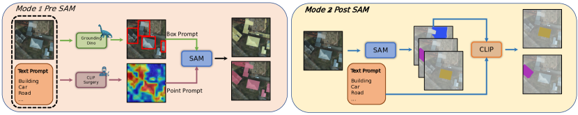
In this study, we propose multiple methods that utilize other foundation models for visual prompt engineering, categorized into two classes: pre-SAM and post-SAM methods, see Figure 1.
The pre-SAM methods involve pre-selecting object areas using points and bounding boxes based on text prompts. We utilize Grounding DINO [20] and CLIP Surgery [22] for this purpose. Grounding DINO takes a text prompt as input and returns corresponding bounding boxes for referred objects, while CLIP Surgery returns a set of points to denote the corresponding objects. These bounding boxes and points serve as input for the SAM model to help localize the target objects of a certain class. For the post-SAM method, We utilized SAM first to get all the segmentation objects, then use this result as inputs to CLIP[6] to perform further filtering based on specific text prompts to get the targeted class of objects. This process is based on the ability CLIP learned to capture the similarities between images and corresponding text prompts.
3 Experiments
In our experiment, we first test how SAM performs using the generic sampled points as prompt. Although in this mode SAM can not be guided to generate a specific semantic category, it can help to understand to what extent SAM can perform segmentation. After that, we tested how to design the best practice for combining multiple visual foundation models to help generate visual prompt to guide the SAM model to do semantic segmentation. We test our pipeline with different combinations. Specifically, we test 1. using Grounding DINO + SAM, 2. using CLIP Surgery + SAM, 3. using SAM + CLIP, 4. using Grounding DINO + CLIP Surgery + SAM, and 5. using Grounding DINO + CLIP Surgery + SAM + CLIP. We test these combinations on four different remote sensing datasets including UAVid[10], Vaihingen[12], Potsdam[12], and LoveDA[23].
3.1 Apply SAM for generic instance segmentations on remote sensing dataset
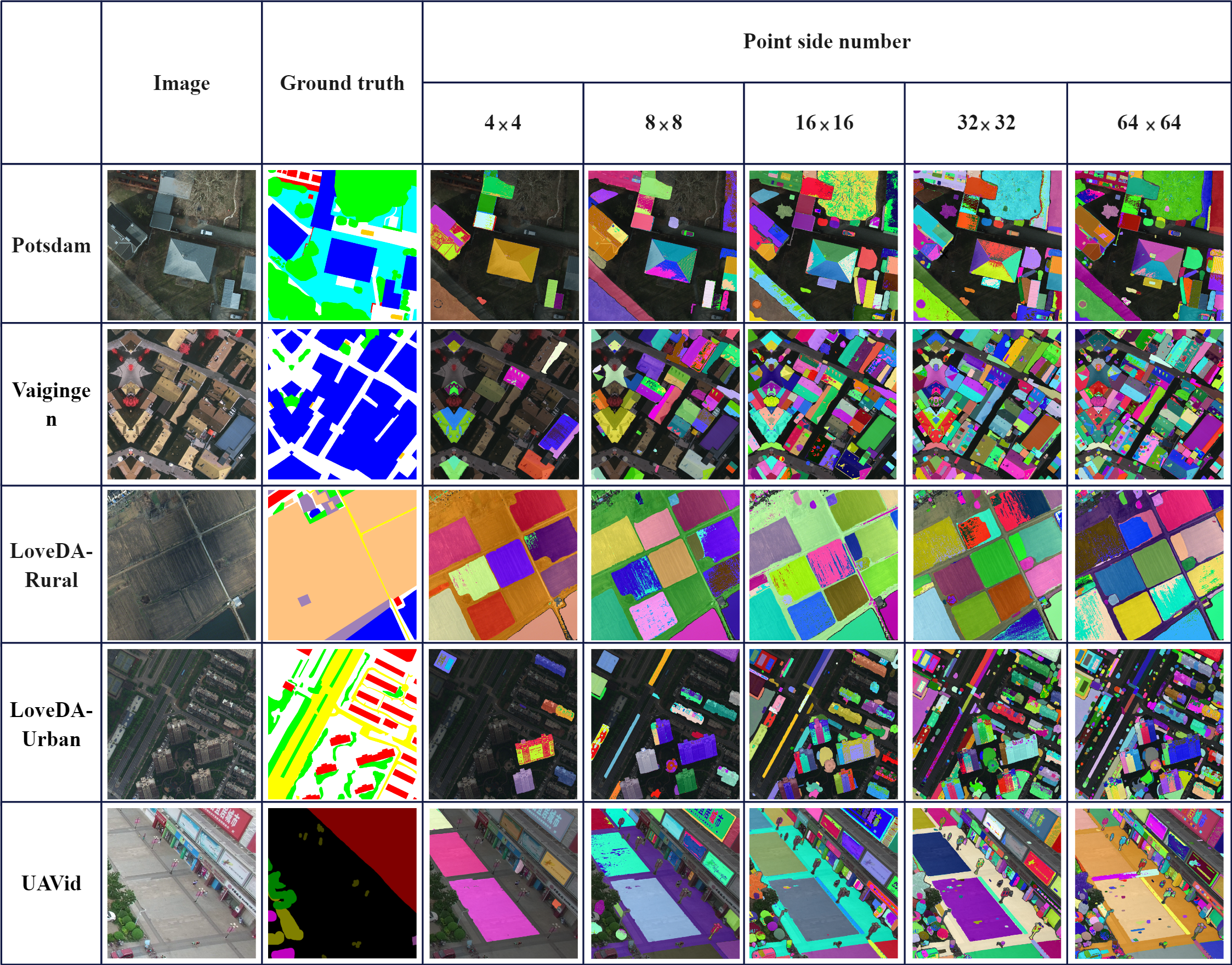
We initially evaluate the generic SAM for segmentation on remote sensing images. The original SAM model [8] introduced four categories of visual prompts that can be employed, including points, boxes, text, and masks. They also provide an interactive demo illustrating the usage of these prompts (except text). In this study, we adopt points as our visual prompts, applying a uniform distributed number of points onto the image as pseudo-prompts. By doing so, we aim to test the performance boundary of the SAM model on remote sensing datasets, assessing whether it can segment all objects within a given image frame.
It is worth noting that the generic SAM samples points as a grid in the input image, using the sampled points as guides to generate segmentation masks. Consequently, the number of points per side determines the granularity of predictions. A higher number of points per side typically results in a greater number of segmented instances; however, this requires significantly more resources for inference and may further divide a single object into multiple parts. In our experiments, we tested points per side within a range of 4 to 64. As seen in Figure 2, a higher points per side parameter generally benefits the model, particularly when multiple small objects are present within the frame. Thus, in subsequent sections, we adopt 64 points per side as our default parameter unless otherwise specified.
3.2 UAVid dataset
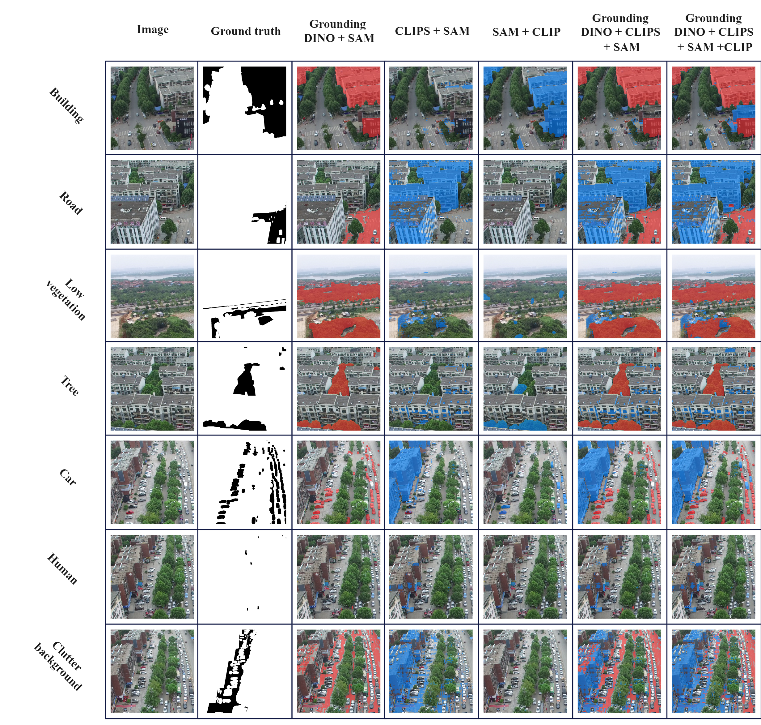
The UAVid dataset is a high-resolution UAV semantic segmentation dataset focusing on urban street scenes, providing two distinct spatial resolutions (3840x2160 and 4096x2160) and encompassing eight classes, as detailed in [10]. Segmentation of UAVid images poses challenges due to their high spatial resolution, diverse spatial features, ambiguous categories, and complex scenes. We employed the officially provided set of 150 images to demonstrate our findings. In our experimental methodology, each image was padded and partitioned into eight 1024x1024 pixel patches, adhering to the procedure described in [16]. Based on our qualitative assessment (Figure 3), DINO+SAM frequently produces the most accurate and conservative segmentation results. Conversely, in some instances, CLIPS may segment objects erroneously. Overall, the DINO+CLIPS+SAM+CLIP combination yields the most comprehensive segmentation outcomes, encompassing the majority of objects.
3.3 LoveDA dataset
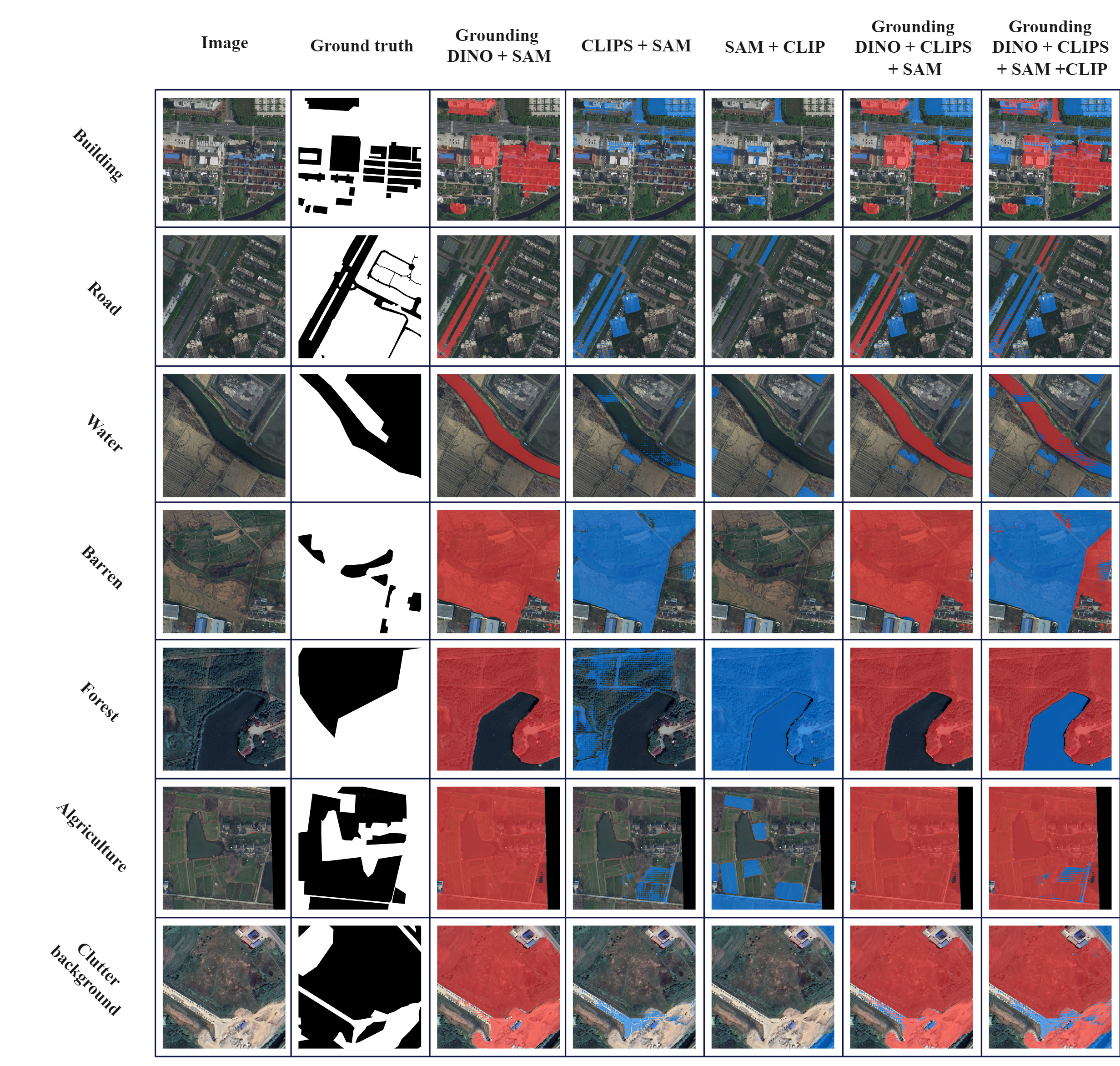
The LoveDA dataset[23] comprises 5987 fine-resolution optical remote sensing images (GSD 0.3 m), each measuring 1024 by 1024 pixels, and features 7 land cover categories: building, road, water, barren, forest, agriculture, and background[23]. The dataset covers two scenes (urban and rural) collected from three Chinese cities: Nanjing, Changzhou, and Wuhan. This variety introduces considerable challenges due to the presence of multiscale objects, complex backgrounds, and inconsistent class distributions.
From the results (Figure 4), we observe that our pipeline performs more effectively for categories such as buildings, roads, or water. However, generating accurate segmentation maps for categories like barren, forest, agriculture, or background proves to be difficult. We hypothesize that this is due to the inherent challenges in accurately defining these concepts, leading to less precise visual prompts generated by the models.
3.4 Vaihingen dataset
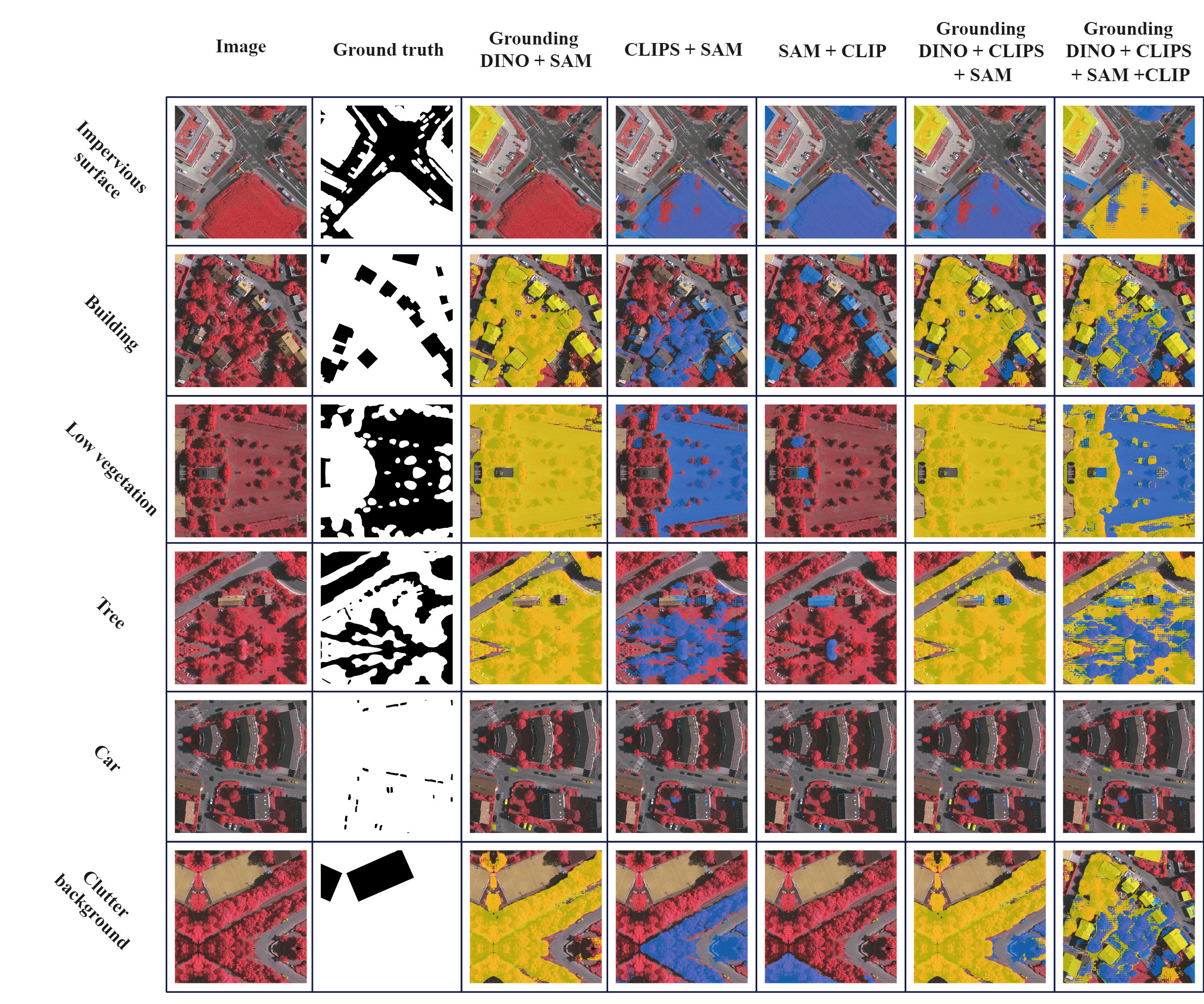
The Vaihingen dataset[12] consists of 33 high-resolution TOP image tiles, averaging 2494x2064 pixels in size. Each tile features three multispectral bands (near-infrared, red, and green) and includes both a digital surface model (DSM) and a normalized digital surface model (NDSM) with a 9 cm ground sampling distance (GSD). The dataset contains five foreground classes (impervious surface, building, low vegetation, tree, and car) and one background class. In our experiments, we only used the TOP image tiles without the DSM and NDSM data. These image tiles were then cropped into patches measuring 1024 by 1024 pixels each.
The Vaihingen dataset (Figure 5) displayed notably low performance in our experiments. For instance, while most methods perform well on segmenting trees in other datasets, the pipeline frequently fails to do so for this dataset. We attribute this issue to the Vaihingen dataset’s utilization of near-infrared (NIR) equipment for data acquisition, which causes trees to appear red. This phenomenon can confuse generic visual models.
3.5 Potsdam dataset
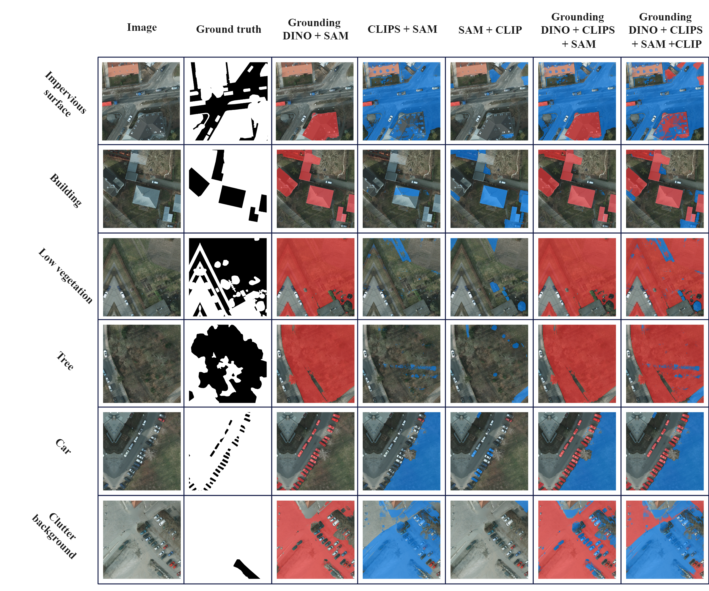
The Potsdam dataset [12] comprises 38 high-resolution TOP image tiles (GSD 5 cm), each measuring 6000x6000 pixels, and encompasses the same category information as the Vaihingen dataset. This dataset provides four multispectral bands (red, green, blue, and near-infrared) in addition to the DSM and NDSM. In our experiments, we utilized only the red, green, and blue bands, and cropped the original image tiles into patches of 1024 by 1024 pixels.
Analogous to the findings from the Vaihingen dataset, the Potsdam dataset also exhibited imbalanced performance across various semantic categories (Figure 6). For well-defined concepts, such as buildings or cars, the results were highly promising. However, the FMs encountered difficulties in comprehending more general concepts, such as impervious surfaces, low vegetation, or background.
4 Conclusion
In this paper, we propose that leveraging existing visual foundation models enables their efficient repurposing for specific tasks, such as remote sensing semantic segmentation. Our findings suggest that although the SAM model effectively segments instances within the provided frame, generating segmentation masks for a specific category remains challenging. In contrast, other visual foundation models, like Grounding DINO and CLIP, exhibit a superior capacity to understand the semantic features of images, thus generating coarse-grained visual prompts. Integrating these models into a unified pipeline allows us to exploit their combined strengths. However, our evaluation of remote sensing datasets reveals that despite the strong performance of such foundation models on standard datasets, the unique characteristics of remote sensing data, such as varying color channels and views, still pose challenges for accurate recognition. Consequently, designing or repurposing foundation models for specific domains and performing effective visual prompt engineering are open questions requiring further exploration. We hope that our preliminary evaluation and proposed pipeline will encourage additional research on the application of visual foundation models for diverse downstream tasks and stimulate the development of increasingly powerful visual foundation models.
References
- [1] Sébastien Bubeck, Varun Chandrasekaran, Ronen Eldan, Johannes Gehrke, Eric Horvitz, Ece Kamar, Peter Lee, Yin Tat Lee, Yuanzhi Li, Scott Lundberg, et al. Sparks of artificial general intelligence: Early experiments with gpt-4. arXiv preprint arXiv:2303.12712, 2023.
- [2] Som S Biswas. Potential use of chat gpt in global warming. Annals of Biomedical Engineering, pages 1–2, 2023.
- [3] Som S Biswas. Role of chat gpt in public health. Annals of Biomedical Engineering, pages 1–2, 2023.
- [4] Tiffany H Kung, Morgan Cheatham, Arielle Medenilla, Czarina Sillos, Lorie De Leon, Camille Elepaño, Maria Madriaga, Rimel Aggabao, Giezel Diaz-Candido, James Maningo, et al. Performance of chatgpt on usmle: Potential for ai-assisted medical education using large language models. PLoS digital health, 2(2):e0000198, 2023.
- [5] Nigar M Shafiq Surameery and Mohammed Y Shakor. Use chat gpt to solve programming bugs. International Journal of Information Technology & Computer Engineering (IJITC) ISSN: 2455-5290, 3(01):17–22, 2023.
- [6] Alec Radford, Jong Wook Kim, Chris Hallacy, Aditya Ramesh, Gabriel Goh, Sandhini Agarwal, Girish Sastry, Amanda Askell, Pamela Mishkin, Jack Clark, et al. Learning transferable visual models from natural language supervision. In International conference on machine learning, pages 8748–8763. PMLR, 2021.
- [7] Junnan Li, Dongxu Li, Caiming Xiong, and Steven Hoi. Blip: Bootstrapping language-image pre-training for unified vision-language understanding and generation. In International Conference on Machine Learning, pages 12888–12900. PMLR, 2022.
- [8] Alexander Kirillov, Eric Mintun, Nikhila Ravi, Hanzi Mao, Chloe Rolland, Laura Gustafson, Tete Xiao, Spencer Whitehead, Alexander C Berg, Wan-Yen Lo, et al. Segment anything. arXiv preprint arXiv:2304.02643, 2023.
- [9] Yezhen Cong, Samar Khanna, Chenlin Meng, Patrick Liu, Erik Rozi, Yutong He, Marshall Burke, David Lobell, and Stefano Ermon. Satmae: Pre-training transformers for temporal and multi-spectral satellite imagery. Advances in Neural Information Processing Systems, 35:197–211, 2022.
- [10] Ye Lyu, George Vosselman, Gui-Song Xia, Alper Yilmaz, and Michael Ying Yang. Uavid: A semantic segmentation dataset for uav imagery. ISPRS journal of photogrammetry and remote sensing, 165:108–119, 2020.
- [11] N Haala, M Cramer, and Karsten Jacobsen. The german camera evaluation project-results from the geometry group. In International Archives of the Photogrammetry, Remote Sensing and Spatial Information Sciences:[2010 Canadian Geomatics Conference And Symposium Of Commission I, ISPRS Convergence In Geomatics-Shaping Canada’s Competitive Landscape] 38 (2010), Nr. Part 1, volume 38. Göttingen: Copernicus GmbH, 2010.
- [12] Franz Rottensteiner, Gunho Sohn, Jaewook Jung, Markus Gerke, Caroline Baillard, Sebastien Benitez, and Uwe Breitkopf. The isprs benchmark on urban object classification and 3d building reconstruction. ISPRS Annals of the Photogrammetry, Remote Sensing and Spatial Information Sciences I-3 (2012), Nr. 1, 1(1):293–298, 2012.
- [13] Weiwei Sun and Ruisheng Wang. Fully convolutional networks for semantic segmentation of very high resolution remotely sensed images combined with dsm. IEEE Geoscience and Remote Sensing Letters, 15(3):474–478, 2018.
- [14] Xiaohui Yuan, Jianfang Shi, and Lichuan Gu. A review of deep learning methods for semantic segmentation of remote sensing imagery. Expert Systems with Applications, 169:114417, 2021.
- [15] Xin He, Yong Zhou, Jiaqi Zhao, Di Zhang, Rui Yao, and Yong Xue. Swin transformer embedding unet for remote sensing image semantic segmentation. IEEE Transactions on Geoscience and Remote Sensing, 60:1–15, 2022.
- [16] Libo Wang, Rui Li, Ce Zhang, Shenghui Fang, Chenxi Duan, Xiaoliang Meng, and Peter M Atkinson. Unetformer: A unet-like transformer for efficient semantic segmentation of remote sensing urban scene imagery. ISPRS Journal of Photogrammetry and Remote Sensing, 190:196–214, 2022.
- [17] Gengchen Mai, Chris Cundy, Kristy Choi, Yingjie Hu, Ni Lao, and Stefano Ermon. Towards a foundation model for geospatial artificial intelligence (vision paper). In Proceedings of the 30th International Conference on Advances in Geographic Information Systems, pages 1–4, 2022.
- [18] Gengchen Mai, Weiming Huang, Jin Sun, Suhang Song, Deepak Mishra, Ninghao Liu, Song Gao, Tianming Liu, Gao Cong, Yingjie Hu, et al. On the opportunities and challenges of foundation models for geospatial artificial intelligence. arXiv preprint arXiv:2304.06798, 2023.
- [19] Tianrun Chen, Lanyun Zhu, Chaotao Ding, Runlong Cao, Shangzhan Zhang, Yan Wang, Papa Mao, and Ying Zang. Sam fails to segment anything?–sam-adaptor: Adapting sam in underperformed scenes. 2023.
- [20] Shilong Liu, Zhaoyang Zeng, Tianhe Ren, Feng Li, Hao Zhang, Jie Yang, Chunyuan Li, Jianwei Yang, Hang Su, Jun Zhu, et al. Grounding dino: Marrying dino with grounded pre-training for open-set object detection. arXiv preprint arXiv:2303.05499, 2023.
- [21] Alec Radford, Jong Wook Kim, Chris Hallacy, Aditya Ramesh, Gabriel Goh, Sandhini Agarwal, Girish Sastry, Amanda Askell, Pamela Mishkin, Jack Clark, et al. Learning transferable visual models from natural language supervision. In International confence on machine learning, pages 8748–8763. PMLR, 2021.
- [22] Yi Li, Hualiang Wang, Yiqun Duan, and Xiaomeng Li. Clip surgery for better explainability with enhancement in open-vocabulary tasks. arXiv preprint arXiv:2304.05653, 2023.
- [23] Junjue Wang, Zhuo Zheng, Ailong Ma, Xiaoyan Lu, and Yanfei Zhong. Loveda: A remote sensing land-cover dataset for domain adaptive semantic segmentation. arXiv preprint arXiv:2110.08733, 2021.