Radar-Camera Fusion for Object Detection and Semantic Segmentation in Autonomous Driving:
A Comprehensive Review
Abstract
Driven by deep learning techniques, perception technology in autonomous driving has developed rapidly in recent years, enabling vehicles to accurately detect and interpret surrounding environment for safe and efficient navigation. To achieve accurate and robust perception capabilities, autonomous vehicles are often equipped with multiple sensors, making sensor fusion a crucial part of the perception system. Among these fused sensors, radars and cameras enable a complementary and cost-effective perception of the surrounding environment regardless of lighting and weather conditions. This review aims to provide a comprehensive guideline for radar-camera fusion, particularly concentrating on perception tasks related to object detection and semantic segmentation. Based on the principles of the radar and camera sensors, we delve into the data processing process and representations, followed by an in-depth analysis and summary of radar-camera fusion datasets. In the review of methodologies in radar-camera fusion, we address interrogative questions, including “why to fuse”, “what to fuse”, “where to fuse”, “when to fuse”, and “how to fuse”, subsequently discussing various challenges and potential research directions within this domain. To ease the retrieval and comparison of datasets and fusion methods, we also provide an interactive website: https://radar-camera-fusion.github.io.
Index Terms:
Autonomous driving, radar-camera fusion, object detection, semantic segmentation.I Introduction
Autonomous driving has excellent potential in mitigating traffic congestion and improving driving safety. Perception, akin to eyes in autonomous driving, constitutes the foundation for successive functions, such as motion prediction, path planning and maneuver control [1, 2]. To achieve optimal accuracy and robustness of the perception system, various sensors are integrated into autonomous vehicles, allowing for the utilization of their complementary and redundant characteristics [3, 4]. However, which sensors to choose and how to fuse the data between different sensors have emerged as challenging issues requiring further exploration.
Given the rich semantic information that can be perceived, cameras are widely utilized in autonomous driving for object detection, segmentation and tracking. LiDARs calculate the distance to surrounding objects by measuring the time difference of the laser beam from emission to reception via the objects. The denser the laser layers emitted by a LiDAR sensor, the clearer an object’s three-dimensional (3D) contour. These complementary features provided by cameras and LiDARs have made LiDAR-camera sensor fusion a hot topic in recent years, and achieved high accuracy in two-dimensional (2D) and 3D object detection [6, 7, 8, 9], semantic segmentation [10, 11] and object tracking [12, 13]. Despite their strengths, both LiDARs and cameras suffer from the same defect of being sensitive to adverse weather conditions (e.g., rain, fog, snow) that can significantly diminish their field of view and object recognition capabilities [14]. Moreover, the high cost of LiDAR products has brought certain difficulties in promoting their widespread adoption [15].
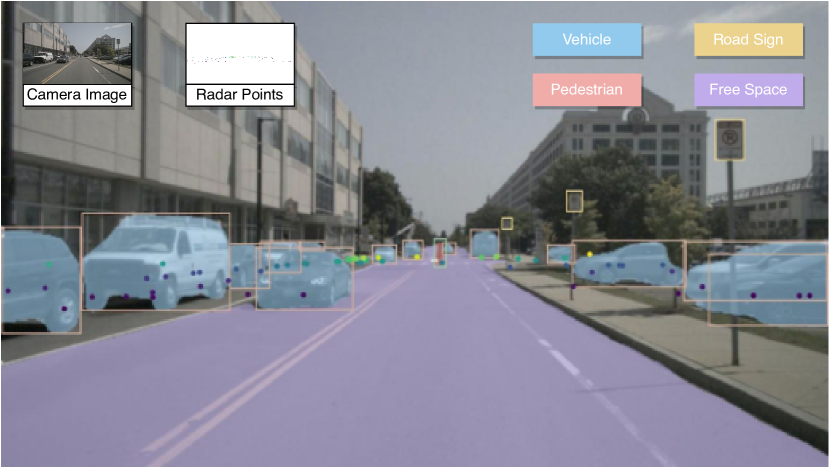
Compared to LiDARs and cameras, radars exhibit superior effectiveness under challenging lighting and weather conditions [16, 17]. Radars can also deliver accurate velocity estimation for all detected objects depending on the Doppler effect without requiring any temporal information [18]. With these characteristics, radars are widely used in Advanced Driving Assistance Systems (ADAS) applications, including collision avoidance, Adaptive Cruise Control (ACC), Lane Change Assist (LCA) and Automatic Emergency Braking (AEB). As depicted in Figure 1, the integration of radar and camera data in sensor fusion enables a comprehensive perception of the surrounding environment in terms of outlines, colors, textures, ranges, and velocities. Moreover, the fusion system can operate continuously throughout the day regardless of weather and lighting conditions.
Although radar sensors are popularly applied to vehicles, few studies focus on data fusion from radars and cameras. One reason for this is the limitations of radar output data, such as low resolution, sparse point clouds, uncertainty in elevation and clutter effects. Another reason is that up to now, the datasets containing both radar and camera data for autonomous driving applications are insufficient, making it challenging for researchers to conduct in-depth analysis. Additionally, applying or adapting existing LiDAR-based algorithms to radar point clouds yields poor results due to inherent differences of point clouds between the LiDAR sensor and radar sensor [18]. Radar point clouds are significantly sparser than their LiDAR counterparts, making it inefficient to extract objects’ geometry information using LiDAR-based algorithms. Although Radar Cross Section (RCS) values in the radar sensor indicate the reflective intensity from the surface of an object, they are easily affected by numerous factors and cannot be used singularly to determine the classification of the target. In addition, though aggregating multiple radar frames enhances the density of the point clouds, it also causes a delay to the whole system. In summary, radar-camera fusion perception is significant in autonomous driving as well as challenging in implementation.
I-A Related Surveys
Most sensor fusion surveys focus on LiDAR-camera [19, 20, 2, 21], or the broader field of multi-sensor fusion, including LiDAR, camera, radar and other sensors [3, 21, 22, 23]. Specifically, in multi-sensor fusion surveys, LiDARs and cameras are still the main research objectives. For example, Feng et al. [3] conducted a comprehensive survey on deep multi-modal object detection and semantic segmentation for autonomous driving. However, this survey mainly concentrates on fusion methods based on LiDARs and cameras, and briefly mentions some studies combining camera images and radar data.
To the best of our knowledge, [24] is the only survey that primarily focuses on radar-camera fusion for object detection in autonomous driving. However, it does not cover the radar-camera fusion dataset or the semantic segmentation task.
I-B Contributions
With the limited focus on radar-camera fusion in existing surveys, it is challenging for researchers to gain an overview of this emerging research field. Our survey attempts to narrow this gap by providing a comprehensive review of radar-camera fusion in autonomous driving. The contributions of our review are summarized as follows:
-
•
To the best of our knowledge, this is the first survey focusing on two fundamental perception problems for radar-camera fusion, namely, object detection and semantic segmentation.
-
•
We present an up-to-date (2019 - 2023) overview of radar-camera fusion datasets and algorithms, and conduct in-depth research on “why to fuse”, “what to fuse”, “where to fuse”, “when to fuse”, and “how to fuse”.
-
•
We analyze the critical challenges and open questions in radar-camera fusion, and put forward potential research directions.
-
•
We provide an interactive and updated website for better retrieving and comparing the fusion datasets and methods.
II Background
This section provides background information on radar-camera fusion in autonomous driving. We first introduce the working principles, sensor characteristics and data representations of the radar and camera sensors. By comparing the characteristics of the two sensors, we aim to demonstrate the importance of radar-camera fusion. Subsequently, as the perception module leverages data from specific sensors to understand the surroundings, we present basic concepts and highlight representative algorithms for two fundamental and crucial perception tasks: object detection and semantic segmentation.
II-A Radar Sensors
II-A1 Working Principles
Radar is the abbreviation of Radio Detection And Ranging, which calculates the range and velocity of the target by transmitting radio waves and receiving the reflected waves from the target [25]. In autonomous driving applications, radar typically refers to the MilliMeter-Wave (MMW) radar that works in the millimeter wave band with a wavelength of 1-10mm and frequency of 76-81GHz. Specifically, the radar equipped in the forward direction, as well as the four corner directions, is usually a Multiple-Input Multiple-Output (MIMO) radar, while the radar on the roof is typically a mechanical rotating radar. A MIMO radar utilizes multiple antennas and transmitters to simultaneously transmit and receive multiple signals with different frequencies. In contrast, a mechanical rotating radar operates with a single antenna that physically rotates to emit radar signals in different directions. With multiple antennas and beamforming capabilities, a MIMO radar achieves higher spatial resolution and interference reduction compared to mechanical rotating radar. While a mechanical rotating radar provides better coverage and is simpler in implementation.
Based on the Time of Flight (TOF) principle, the radar sensor calculates the range from the object by the time difference between the transmitted and reflected signals. Based on the Doppler principle, when there is a relative movement between the emitted electromagnetic wave and the detected target, the frequency of the returned wave differs from that of the emitted wave. Thus, the target’s relative velocity to the radar can be measured using this frequency difference. Leveraging the array signal processing method, the azimuth angle is calculated using the signal’s phase difference between parallel antennas. Since the receivers of traditional 3D (range, Doppler velocity and azimuth angle) radar sensors are only lined up in a 2D direction, targets are only detected in 2D horizontal coordinates without vertical height information. Recently, with advancements in radar technologies, 4D (range, Doppler velocity, azimuth angle and elevation angle) radar sensors have been developed with antennas arranged horizontally and vertically, enabling the measurement of elevation information. In addition, 4D is often represented as x, y, z coordinates and Doppler velocity.
II-A2 Sensor Characteristics
In addition to the ability to measure range, Doppler velocity and azimuth angle, electromagnetic waves in the millimeter wave band have low atmospheric attenuation and better penetration of rain, smoke and dust [26]. These characteristics make the radar sensor work all day regardless of severe weather conditions. However, radar sensors still have certain limitations. They exhibit low angular resolution and cannot distinguish between closely located objects. The point clouds generated by radars are sparsely distributed, with only a few points on a pedestrian and a dozen points on a car. These points cannot adequately outline an object’s contours, making it challenging to extract the geometric information [27, 28]. Doppler radar measurements have a limitation in that they only provide the radial component of velocity. The lack of tangential velocity makes it difficult to estimate the accurate velocity of an object in dynamic scenes [29, 30]. Besides, data produced by radars are noisy, which may arise from diverse sources such as multipath interference, electrical interference and equipment imperfections [31, 32]. Such noise reduces the precision and reliability of radar data, while also increasing the probability of false detections. Furthermore, radars are weak in the perception of stationary obstacles. Moving targets can be distinguished from the surrounding scene in one dimension of range and velocity. However, radars are highly sensitive to metal, often resulting in strong reflections from stationary objects such as manhole covers on the ground. Strong reflections from stationary objects are not filtered, resulting in a lack of detecting stationary obstacles.
II-A3 Data Representations
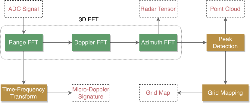
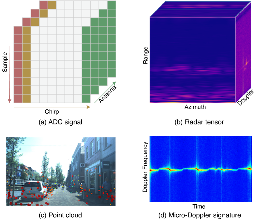
As depicted in Fig. 2, the raw output of a radar sensor is the ADC signal, which refers to the output signal of an Analog-to-Digital Converter (ADC). At this stage, the signal lacks spatial coherence between the values as all the information exists in the time domain [36]. Besides, the signal is represented in complex value which contains real part and imaginary part [37]. To represent the ADC signal in a more structured form, it is usually transformed into a 3D Sample-Chirp-Antenna (SCA) tensor, as illustrated in Fig. 3(a). Some researchers apply 3D Fast Fourier Transform (FFT) along the sample, chirp and antenna dimensions to get an image-like representation named radar tensor (Fig. 3(b)), describing the spatial pattern of the received echo [16, 17]. At this stage, the non-coherent combination (e.g., norm calculation) converts ADC signals composed of complex values to radar tensors that consists of real values. With these three features in Range-Azimuth-Doppler (RAD) coordinates, two forms of radar tensors are formed: one is in 2D including the Range-Azimuth (RA) tensor, Range-Doppler (RD) tensor and Azimuth-Doppler (AD) tensor; the other is the whole 3D RAD tensor, with each side consisting of a 2D tensor. Furthermore, peak detection is carried out on the radar tensor to filter out clutter, resulting in a sparse point-like representation called the point cloud, as depicted in Fig. 3(a). The point cloud provides a spatially intuitive representation better suited for visualization and interpretation, yet it can not accurately indicate the outline information [38, 39]. Constant False Alarm Rate (CFAR) is the most commonly used method for peak detection, which enables the radar system to automatically adjust its sensitivity level to changes in the strength of external interference, thereby maintaining a steady false alarm rate [40, 41]. By applying grid mapping methods to point clouds accumulated over a given period, a grid map for identifying static objects is generated. There are two main grid maps: one is the occupancy-based grid map [42, 43, 44], which represents the obstacles and free-space derived from the radar data; the other is the amplitude-based grid map [42, 45], which displays the RCS values for each cell. However, it is essential to note that the sparsity of the point clouds still influences the accuracy of detection and segmentation performed on the grid map. In addition, some researchers perform Time-Frequency transform after the Range-FFT to obtain the micro-Doppler signature, which is utilized to recognize objects with tiny motion features [35, 46]. As exemplified in Fig. 3(d), the Doppler frequency of a pedestrian walking shows a periodic variation. This representation enables not only the distinction of different object categories (e.g., pedestrians, bicycles and vehicles), but also the recognition of complex object behaviors, such as gait and gesture recognition.
II-B Camera Sensors
II-B1 Working Principles
The camera sensor usually consists of a lens, an image sensor, an Image Signal Processor (ISP) and an Input/Output (I/O) interface [47]. The lens collects the light reflected from the target and converges it to the image sensor. Then, the image sensor converts light waves into electrical signals and converts electrical signals to digital values via an on-chip ADC. After that, the ISP performs post-processing (e.g., noise reduction) and converts the digital values into a format of RGB data for images or videos. Finally, the image data is transferred and displayed via the I/O interface.
II-B2 Sensor Characteristics
Cameras capture the rich appearance features of the objects, including colors, shapes and textures. After learning from neural networks, these features can be utilized to identify obstacles, including vehicles, pedestrians, bicycles and various traffic lights. However, cameras are passive sensors, indicating that the formation of an image requires incident light intake. When the light intake is adversely affected, such as insufficient light at night, extreme weather, water droplets or dust sticking to the lens, the imaging results will be unclear, and object detection performance may be significantly affected [48]. Besides, in autonomous driving, it is crucial to identify the distances of obstacles ahead. However, a target in three dimensions in the world coordinate system becomes a 2D target in the image coordinate system after being imaged by the camera sensor, resulting in a loss of distance information.
II-B3 Data Representations
Raw data representation is the uncompressed and unprocessed format captured by the camera sensor. It contains all the radiance information that hits each pixel on the camera sensor during image exposure [49, 50]. After post-processing, a data representation named RGB image is generated, which illustrates an image as a grid of pixels, with each pixel containing a value for each of the red, green and blue color channels. In addition, some modern cameras applied in autonomous driving are able to generate specific data representations. For instance, a depth camera produces the depth map representation, providing information about the distance to each pixel in the scene [51]. Relying on flood-light flash laser sources, infrared cameras output the infrared image representation, which is able to render perception results in adverse weather and low-light conditions [52, 53]. Event cameras are bio-inspired vision sensors that generate an event image representation pertaining to pixel-level changes in brightness. With sub-millisecond latency, high-dynamic range, and robustness to motion blur, event cameras present considerable potential for real-time detection and tracking of objects in time-critical scenarios [54].
II-C Comparison of Radar and Camera Sensors
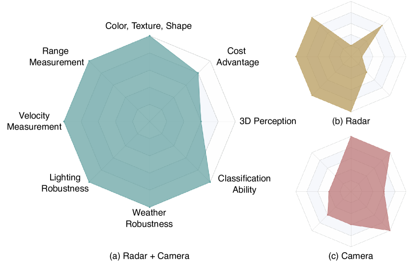
Through our extensive review, a clear and concise figure is designed to compare the characteristics of the two sensors, shown in Fig. 4. Specifically, the radar sensor is an active sensor and measures various information, including ranges, velocities and azimuth angles [55]. Nowadays, radars equipped in driver-assistance systems can detect up to 300 meters, with a 140∘ horizontal field of view and a less than 1∘ angular resolution [56, 57]. In addition, the radar sensor is robust to darkness and extreme weather conditions, allowing it to work throughout the day. The camera sensor is a passive sensor that provides colors, textures and shapes of objects. With a resolution of up to 2K, the camera sensor performs much better in classification than the radar sensor. As far as system cost goes, both radars and cameras are relatively cost-effective and are mass-applied in vehicles.
To sum up, both the radar and camera have their strengths and weaknesses, and they cannot be substituted for each other. The most effective way to ensure adequate information acquisition is mutual integration. Based on their respective characteristics, complementary advantages can improve scenario understanding performance. In addition, when one of the sensors fails, the remaining one can continue working, thus increasing the reliability of the autonomous driving system. Hence, the fusion of radar and camera sensors is critical for perception accuracy and robustness in autonomous driving.
II-D Perception Tasks
II-D1 Object Detection
The object detection task involves identifying a particular object in a camera image or a radar scan, locating its position and determining its category. Generally speaking, researchers use a rectangular or cubic bounding box to encompass the object. As there is no depth channel in 2D object detection, the rectangular bounding box is expressed as , where is the bounding box center, and are the height and width of the bounding box, and is the class of the object. While the cubic bounding box for 3D object detection is described as , where represents the center of the 3D bounding box, , and are the height, width and length of the bounding box, is the object’s orientation, and is its class. Bird’s Eye View (BEV) object detection is a specialized form of 3D object detection focusing on detecting objects from a top-down perspective. In this approach, height information is typically discarded, and objects are represented as 2D bounding boxes on the ground plane.
Camera-based Object Detection
In autonomous driving, camera-based object detection approaches have been widely used in detecting vehicles [58, 59], pedestrians [60, 61, 62], traffic lights [63, 64, 65, 66], and traffic signs [67, 68, 69]. According to different training steps, CNN-based object detection algorithms can be classified into two-stage and one-stage. Two-stage detection algorithms (e.g., R-CNN [70], SPPNet [71], Fast R-CNN [72], Faster R-CNN [73], FPN [74]) segregate the detection problem into two stages: the first step is to generate region proposals, and the second step is to refine the position and predict the classification of each object. Experimental results of these algorithms are high in precision and recall, but relatively slow in time. Without the region proposal generation phase, one-stage detection algorithms simultaneously predict the bounding boxes and the probability of classes within these boxes. Thus, one-stage detection algorithms are commonly faster than two-stage detection algorithms, but lower in accuracy. Some highly representative one-stage object detectors include the YOLO series [75, 76, 77, 78, 79, 80, 81, 82], SSD [83] and RetinaNet [84].
Exploiting the self-attention mechanism that enables the model to model the contextual features and their correlation, transformer-based methods have emerged as a recent breakthrough compared to CNN-based detectors. Some representative pure transformer detectors include DETR [85], Deformable DETR [86], RT-DETR [87], WB-DETR [88], Swin [89] and YOLOS [90]. Additionally, plenty of studies have endeavored to accelerate the conventional transformer block by the combination of convolution and self-attention, aggregating the advantages of both CNN and transformer, as exemplified by Conformer [91], EdgeViTs [92], MobileViT [93], ViTAE [94] and Visformer [95].
Radar-based Object Detection
Radar-based object detection approaches have been widely used in detecting vehicles [16, 17], pedestrians [96, 97] and static objects [98]. As radar tensors are image-like representations, researchers generally utilize image-based networks (e.g., ResNet [99], Faster R-CNN [73], YOLOv4 [78]) to perform object detection on 2D RA tensors [100, 101, 17], 2D RD tensors [102, 103] and 3D RAD tensors [16, 104, 96, 97, 105]. Unlike images, radar tensors lack a physical interpretation, thereby presenting difficulties in translating the learned features from image-based algorithms to radar data. Furthermore, applying algorithms to radar tensors in real-time applications poses challenges due to the high-dimensional nature of radar tensors and the presence of noise, interference and clutter.
For radar data in the format of point clouds, various types of point-based networks are utilized to detect objects. Point-wise methods [106, 107, 108, 109, 110] directly operate on the raw point clouds and leverage LiDAR-based algorithms, such as PointNet [111], PointNet++ [112] and Frustum PointNets [113], to classify the points into distinct object classes. Grid-based methods [114, 108, 115, 116] map the 3D point clouds into grid-like structures, such as 2D image planes or 3D voxel grids. Subsequently, object detection algorithms (e.g., YOLOv3 [77], VoxelNet [117]) are applied to the grid representation to identify objects. The grid-based approaches demonstrate efficiency in handling large datasets and are frequently employed in real-time applications. Graph-based methods (e.g., RadarGNN [39], Radar-PointGNN [98]) in radar point cloud object detection employ the Graph Neural Network (GNN), where the points serve as nodes, and the relationships between the points are modeled as edges in the graph. Leveraging graph structures and algorithms, these methods effectively capture the spatial relationships and contextual information among the points, leading to improved detection performance compared to traditional point-wise methods. However, the construction and feature extraction of graphs are complex and computationally intensive, especially when handling large-scale point clouds.
II-D2 Semantic Segmentation
Semantic segmentation involves clustering the basic components of input data into different semantically relevant regions. Essentially, it refers to assigning selected labels from a pre-defined set to each pixel in an image-based dataset or each point in a point-based dataset .
Camera-based Semantic Segmentation
The technique of camera-based semantic segmentation finds widespread application in the fields of free-space segmentation [118, 119, 120, 121, 122, 123], lane segmentation [124, 125, 126, 127, 120, 121, 123] and obstacle segmentation [128, 129, 130] in autonomous driving. Fully Convolutional Network (FCN) [131] is a milestone in semantic segmentation as it enables end-to-end training of deep networks for this task. However, due to its failure to account for global contextual information, the obtained segmentation results tend to be coarse. Therefore, the encoder-decoder architecture has emerged to address this shortcoming, represented by SegNet [132], U-Net [133] and HRNet [134]. The encoder-decoder architecture typically uses an image classification network as its encoder, gradually reducing the spatial dimensions of the pooling layer. Meanwhile, the decoder gradually restores the details and spatial dimensions for segmentation purposes.
However, for encoder-decoder architectures, high-resolution representations are lost during the encoding process, reducing fine-grained information within the image. Dilated (or “atrous”) convolution structure is created to avoid decimating the input’s resolution by adding a dilation rate to standard convolutions. This architecture enlarges the receptive field without increasing the parameters and avoids the loss of information caused by repeated pooling. Some notable examples of representative networks which apply dilated convolution structure include DeepLab series [135, 136, 137, 138], ENet [139], PSPNet [140], DUC-HDC [141] and DenseASPP [142].
CNNs require multiple decoder stacks to map high-level features to the original spatial resolution. In contrast, transformer-based models can be graciously combined with a lightweight transformer decoder for segmentation mask prediction due to their global modeling capability and resolution invariance. Recently, transformer-based segmentation models (e.g., SETR [143], Segmenter [144], SegFormer [145], Lawin [146] and MaskFormer [147]) extract global contextual features based on self-attention and achieve remarkable results.
Radar-based Semantic Segmentation
Radar-based semantic segmentation is applied in the fields of vehicle segmentation [38, 148], pedestrian segmentation [44, 149], free-space segmentation [36, 150] and static object segmentation [151, 152] in autonomous driving. Similar to object detection methods in radar-based applications, network architectures vary depending on specific radar representations. These architectures also incorporate algorithms adapted from the image and point cloud domains to enable efficient processing and analysis of radar data. Segmentation on radar tensors refers to the process of dividing the tensor into discrete regions or segments based on specific criteria or properties. The goal is to identify and label different parts or objects in the radar RA tensor [153], RD tensor [154] and RAD semantic segmentation [36, 150, 148, 155, 105], enabling a more comprehensive understanding of the scene. CNN architectures like DeepLabv3+ [138] and U-Net [133] possess the ability to extract intricate features and relationships directly from the radar tensor data, thereby facilitating effective segmentation tasks.
For segmentation on radar point clouds, conventional CNN algorithms (e.g., PointNet and PointNet++) can effectively capture the spatial relationships and semantics of individual radar points to classify them into different categories or segments. These algorithms are widely utilized in point-wise semantic segmentation [38, 106, 156, 157, 158, 159] and grid-based methods [151, 44, 152, 160, 153]. However, the initial data transformation involved in these approaches may result in information loss and sparsity in the data representation. Recent point transformer networks (e.g., Gaussian Radar Transformer (GRT) [161]) enhance performance for 3D point cloud understanding by elaborating the attention mechanism, which is able to capture complex structures in sparse point clouds. In addition to basic semantic segmentation, instance-based segmentation methods [159, 162] not only classify each point in the radar point cloud but also group nearby points together into instances.
III Fusion Datasets
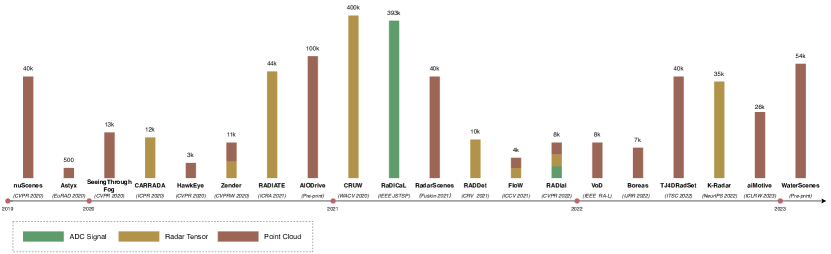
High-quality and large-scale data are fundamental for deep learning-based perception algorithms in autonomous driving. Datasets containing data from LiDARs and cameras, such as KITTI [163], Oxford RobotCar [164], ApolloScape [165], and Waymo [166], have been widely used for LiDAR-camera fusion in autonomous driving. As radar research continues in-depth, dozens of radar and camera datasets have been released in recent years. In this section, we analyze and summarize these datasets designed explicitly for tasks related to object detection and semantic segmentation. Fig. 5 presents clear statistics of radar-camera fusion datasets with their radar representations and dataset sizes. We also provide a table for retrieval and comparison of different datasets (see Table LABEL:tab:datasets).
III-A Dataset Tasks
According to the dimension of bounding boxes and masks, datasets that incorporate radar and camera modalities in object detection and semantic segmentation are categorized into four groups:
- •
- •
- •
-
•
3D semantic segmentation: HawkEye [180].
Regarding dataset tasks, most datasets are oriented toward object detection, whereas comparatively fewer datasets are employed for semantic segmentation tasks. Notably, CARRADA [33], RadarScenes [179] and RADIal [105] can be applied to both object detection and semantic segmentation tasks. As to those datasets that contribute to multiple tasks, nuScenes [5] is the most widely used dataset in radar-camera fusion algorithms, supporting tasks of detection, tracking, prediction and localization. In addition to object detection, RADIATE [168] involves object tracking, scene understanding and SLAM tasks. Moreover, datasets like Zender [167] and Boreas [173] are available for localization and odometry.
III-B Sensing Modalities
For radar-camera fusion datasets in object detection and semantic segmentation tasks, the data produced by the camera sensor is either a single image or a video over a while, both of which are essentially 2D images. In comparison, data produced by the radar sensor is rich in representations, which can be grouped into ADC signal, radar tensor, and point cloud according to the stages of data processing.
III-B1 ADC Signal
As the raw data produced by radar sensors, ADC signals retain all semantic information and can be highly valuable in deep learning applications. Up to now, only two radar-camera fusion datasets provide raw ADC signal data: RaDICaL [171] and RADIal [105]. RaDICaL [171] is the first dataset providing raw ADC signal data, specialized for object detection tasks involving pedestrians and vehicles. The authors encouraged researchers to further design their own processing methods by providing the raw radar measurements. RADIal [105] is the richest dataset regarding radar data representations, offering not only ADC signals, but also processed data after ADC signals, including radar tensors and point clouds.
III-B2 Radar Tensor
After multiple FFTs, radar tensors are obtained from ADC signals. They can be classified into three categories: 2D tensors (e.g., RADIATE [168], CRUW [170], FloW [172]), 3D tensors (e.g., CARRADA [33], Zendar [167], RADDet [97], RADIal [105]) and 4D tensors (e.g., K-Radar [177]). Both RADIATE [168] and CRUW [170] are in range-azimuth coordinates, presenting the BEV position of objects, while the FloW [172] dataset is in range-Doppler coordinates, illustrating the relationship between range and Doppler velocity of each object. CARRADA [33] is the first dataset that combines synchronized stereo RGB images and 3D radar RAD tensors in autonomous driving. As far as we are aware, K-Radar [177] is the only dataset containing 4D radar tensors, with full information on range, Doppler, azimuth and elevation.
III-B3 Point Cloud
Compared to radar tensors, point clouds serve as a lighter and more intuitive representation of objects. They are also the format of data output from commercial radars. Conventional 3D radars produce sparse point clouds, such as data in nuScenes [5], Zender [167], SeeingThroughFog [53], HawkEye [180], AIODrive [169], RADIal [105], FloW [172], RadarScenes [179] and aiMotive [178] dataset. In recent years, the radar sensor has advanced from 3D to 4D with improvements in resolution and elevation measurement capabilities. Consequently, public 4D radar-camera fusion datasets are emerging, with examples such as Astyx [175], VoD [34], TJ4DRadSet [176] and WaterScenes [174]. Although Astyx [175] is the first 4D point cloud dataset, it is limited by the data size, containing only 500 frames. VoD [34] and TJ4DRadSet [176] datasets are improved in terms of data categories and data size, with the former consisting of 13 types and 8,693 frames, and the latter containing eight types and 40k frames. Meanwhile, these two datasets also contain simultaneous LiDAR data, facilitating comparison between the 4D radar point clouds and LiDAR point clouds.
III-C Dataset Categories
For autonomous driving, it is critical to identify Vulnerable Road Users (VRU) on roads. Therefore, the most common categories in these datasets are pedestrians, bicycles, and cars [175, 33, 168, 169, 170, 179, 34]. Datasets such as nuScenes [5], AIODrive [169], RadarScenes [179], VoD [34] and aiMotive [178] have studied more than ten categories. nuScenes [5] provides precision in its classifications, with 23 object categories refining certain ambiguous categories. For instance, the pedestrian category is sub-categorized into groups such as adult and child, while the vehicle category is subclassed into the car, ambulance, police, motorcycle, trailer and truck. Except for the category of pedestrian, RADIATE [168] and RadarScenes [179] include a class called pedestrian group. AIODrive [169] and VoD [34] classify stationary objects on the roadside, such as building, road, wall, traffic sign, unused bicycle and bicycle rack. Furthermore, apart from objects on road surfaces, FloW [172] is a floating waste dataset containing the category of bottle that can be utilized for Unmanned Surface Vehicles (USVs) on water surfaces. WaterScenes [174] contains more objects of interest on water surfaces, including static objects such as piers and buoys, and dynamic objects such as ships, boats, vessels, kayaks, and sailors aboard these surface vehicles.
In addition to the primary object categories, some specific attributes of the object are also labeled in some datasets. Examples can be found in nuScenes [5], in which vehicles are labeled as moving, stopped or parked, while pedestrians are marked as moving or standing. Besides, in VoD [34] dataset, two types of occlusions (“spatial” and “lighting”) and attributes related to an object’s activity (“stopped”, “moving”, “parked”, “pushed” and “sitting”) are also annotated. All these specific attributes are essential for scene understanding.
III-D Dataset Size
The reviewed datasets differ significantly in size, ranging from 500 to 1.4 million frames. nuScenes [5] is the largest dataset with 1.4 million images, radar frames and object bounding boxes in 40k keyframes. These data frames are split from 15 hours and 242 kilometers of driving data. On the other hand, Astyx [175] provides only 500 frames, containing around 3k labeled 3D object annotations. Others like CRUW [170], CARRADA [33], RADIATE [168], AIODrive [169], SeeingThroughFog [53], CRUW [170], RADDet [97] and RADIal [105] all contribute hundreds of thousands of frames.
In addition to data in frames, some datasets deliver videos for researchers to split keyframes and conduct further research on videos. For example, RadarScenes [179] offers 158 individual sequences with a total length of over four hours. Similarly, CRUW [170] and CARRADA [33] datasets provide videos of 3.5 hours and 21.2 minutes, respectively.
III-E Recording Scenarios
A rich data collection environment is crucial for training robust models in autonomous driving. Generally, datasets for autonomous driving are collected in road environments like urban streets, country roads, highways and parking lots, which are all represented in datasets like CARRADA [33], RADIATE [168], RadarScenes [179], RADlal [105], and K-Radar [177]. However, it is not enough to collect data in common areas. nuScenes [5], Zendar [167], SeeingThroughFog [53], AIODrive [169] and CRUW [170] involve dense traffic and challenging driving situations, including urban roads, residential areas and industrial areas. Moreover, RadarScenes [179] offers data for selected particular scenarios, such as T-junctions, commercial areas and road works. All the datasets mentioned above are from outdoor environments, and as to indoor scenarios, HawkEye [180] and RaDICaL [171] are collected in indoor parking garages. These indoor environments present unique challenges and can help advance research in indoor autonomous vehicle navigation.
In terms of weather and lighting conditions, related data can be found in nuScenes [5], SeeingThroughFog [53], CARRADA [33], RADIATE [168], K-Radar [177], AIODrive [169], CRUW [170], TJ4DRadSet [176], aiMotive [178] and WaterScenes [174]. In particular, SeeingThroughFog [53] focuses on extreme weather conditions, like fog, snow and rain. This dataset highlights the importance of data fusion and the redundancy of multiple sensors in adverse weather environments. In addition to adverse weather conditions, RADIATE [168], K-Radar [177] and aiMotive [178] involve conditions for the night. AIODrive [169], CRUW [170] and TJ4DRadSet [176] supply data in specific vision-fail scenarios, such as darkness, bright light and blur, where the images are pretty bad in quality. These datasets provide valuable information about how autonomous driving technology operates in low visibility and low light scenarios. Boreas [173] is a dataset involving data taken from specific routes through one-year repeat collection. It can be leveraged to study the effects of seasonal variation on self-localization and object detection.
Since it is time-cost and resource-cost for data collection on roads, some researchers have adopted simulated data to generate datasets. In HawkEye [180], raw low-resolution heatmaps are transformed into high-frequency shapes. Additionally, the authors developed a data synthesizer to simulate radar signals from the created 3D point reflector models of cars. Meanwhile, Weng et al. [169] used Carla [181] simulator to create different driving scenarios with various sensors. With the annotation data generated by combining and post-processing Carla outputs, they presented AIODrive [169], a large-scale synthetic dataset for all mainstream perception tasks.
IV Fusion Methodologies
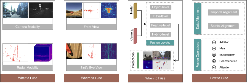
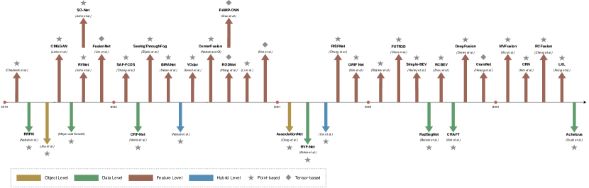
In this section, we delve into the methodologies of radar-camera fusion related to object detection and semantic segmentation tasks, starting with “why to fuse”, that is, the purpose and advantages of fusion. Subsequently, we analyze “what to fuse”, covering diverse representations of both radar and camera modalities implicated in fusion. Next, we investigate “where to fuse”, describing the coordinate relations between the two modalities before fusion. In the section on “when to fuse”, we categorize the fusion levels and illustrate their differences. After that, we explore the specifics of “how to fuse”, including temporal-spatial synchronization and fusion operations. Regarding network architectures for fusion, we categorize them into two architectures: point-based and tensor-based, followed by a more detailed classification of each category and the main ideas in these architectures. Finally, in the model evaluations section, we review various evaluation metrics and assess the performance of popular methods. An overview of radar-camera fusion methodologies containing the questions and answers is demonstrated in Fig. 6.
IV-A Why to Fuse
The integration of radar and camera sensors for object detection and semantic segmentation is intended to enhance the perception outcomes by capitalizing on the advantages of both sensing modalities. As illustrated in Fig. 4 in Section II-C, the combination of a radar sensor and a camera sensor enables the measurement of rich object attributes such as color, shape, range, and velocity. In addition, with the ability to perceive in darkness and adverse weather conditions, the fusion of radar and camera can work all day for autonomous driving vehicles. For autonomous driving tasks, object detection and segmentation results obtained from radar-camera fusion can also assist in object tracking [182, 183], providing accurate environment perception information for the decision-making and control systems. For other downstream tasks, such as trajectory prediction [184] and vehicle navigation [185], radar-camera fusion has successfully demonstrated excellent driving performance in both unseen urban and heavy traffic scenarios.
Numerous studies have also demonstrated that radar-camera fusion improves the accuracy and robustness of the network. As it is difficult for image-based detectors to detect distant objects, Chadwick et al. [186] combined a radar sensor and sets of camera sensors in their experiments. Results exceed the performance of the camera detector, as the radar sensor persists in delivering a potent indication of motion for faraway objects. Major et al. [16] also proved that the velocity dimension derived from the radar sensor could be leveraged to increase detection performance. Additionally, Nabati and Qi [18] utilized radar features (e.g., depth, rotation, velocity) to complement the image features, resulting in an improvement of the overall nuScenes Detection Score (NDS) by more than 12% compared to the SOTA camera-based algorithm including OFT [187], MonoDIS [188] and CenterNet [189]. In noisy circumstances, Yadav et al. [190] discovered that radar data exhibit robustness in detection, and integration of radar data could enhance performance in these challenging scenarios.
IV-B What to Fuse
The objective of radar-camera fusion is the output data from the radar sensor and camera sensor, which are presented in different modalities at various fusion levels and via different fusion techniques. For the camera sensor, the output data is typically presented as 2D images. In radar-camera fusion, there are mainly two kinds of images. One type is the RGB image with rich color information, such as images in nuScenes [5] dataset. The other is the infrared image captured with infrared cameras (including Far Infrared (FIR) and Near Infrared (NIR)), as illustrated in the images from SeeingThroughFog [53] dataset. Though in lower resolutions, these images contain specific advantages in temperature differences and night visibility. The data structure of an image is relatively simple, with low data dimensionality and high correlations between neighboring pixels. The simplicity of this structure allows deep neural networks to learn the fundamental representations of images, thus enabling them to detect objects within the images [177].
As mentioned in Section II-A3, radar data can be classified into different representations depending on the level of processing. ADC Signals, the underlying digital signals of the radar, cannot be marked with the location information of an object. MDS, a Time-Frequency representation, consists of consecutive radar frames and does not correspond to a single image frame. As a result, ADC Signals and MDS are commonly used for identifying the presence of objects and discriminating between different objects [191, 192, 46, 193]. With the ability to describe the shape of an object, radar tensors and point clouds are commonly leveraged for object detection and semantic segmentation tasks.
IV-C Where to Fuse
IV-C1 Front View
Fusion at the Front View (FV) involves projecting the radar data onto an image plane, where the radar data can be 3D point clouds, partial point cloud information or radar tensors. Around the projected area, proposals that indicate potential objects are generated [9, 194, 190, 195, 196]. In this way, a large number of non-object regions are excluded, thus reducing the computational burden and increasing recognition speed. Radar data mapped to the image plane can also be utilized to create feature maps for complementing the image-based features [186, 197, 18, 198]. These methods improve the detection accuracy by leveraging the additional input, including ranges, velocities and RCS values. Moreover, some researchers project radar point clouds onto the image plane to form a radar pseudo-image [28, 199, 200, 201]. For example, In RVNet [28] and SO-Net [199], a pseudo-image named “Sparse Radar Image” is generated from radar data, containing information regarding depth, lateral velocity and longitudinal velocity. Besides, Dong et al. [200] projected both radar point clouds and 2D bounding boxes onto the image plane, forming new pseudo-images from camera RGB images. MS-YOLO [201] generates radar mask maps by a mapping transformation neural network. In each mask map, the boxed area represents the presence of an object, and the gray value of each box indicates the velocity information of that object.
Projecting radar data onto the image plane assists in providing proposals and features. However, due to the low resolution in the azimuth angle provided by the radar as well as camera calibration errors, projected radar point clouds may deviate from the object. While increasing the Region of Interest (RoI) could potentially address the issue, it results in multiple objects within the same region, and consequently being detected repeatedly, causing confusion in object matching. Moreover, due to the occlusion of objects, the projection of radar data onto the image perspective may be limited.
IV-C2 Bird’s Eye View
Another fusion position is to convert radar data or camera images into BEV coordinates. For example, radar point clouds from each frame generate a BEV image of six height maps and one density map in [175]. Besides, Cui et al. [195] projected radar point clouds to both FV and BEV, and proposed a 3D region proposal network to generate proposals from both camera images and radar BEV images. Compared with generating proposals directly from point clouds, the CNN-based proposal generation approach increases the quality of proposals by leveraging the network’s ability to extract deeper and richer information. Problems come that BEV images discretize the sensing space into grids, which may lead to the loss of valuable information necessary to refine bounding boxes. To address this issue, Bansal et al. [202] added additional point-based features (e.g., velocities, RCS values) to the BEV map. Simple-BEV [203] converts all radar point clouds from multiple radar sensors into BEV coordinates to yield high-dimensional BEV feature maps.
Apart from projecting radar data into BEV, Inverse Projection Mapping (IPM) [204, 205] method can be utilized to convert camera images from FV to BEV with a homography matrix. For instance, Lim et al. [206] transformed the camera images into Cartesian coordinates using IPM and then combined them with 2D radar RA tensors. In addition, both radar point clouds and camera images are projected onto BEV in [207], where the independent feature extractors learn shared features. Consequently, projecting data on BEV offers several advantages over FV, particularly in the case of occlusion [208]. Nonetheless, since IPM is based on an assumption of flat road surfaces, it often produces distortions of dynamic objects when applied to real-world scenarios [207].
IV-D When to Fuse
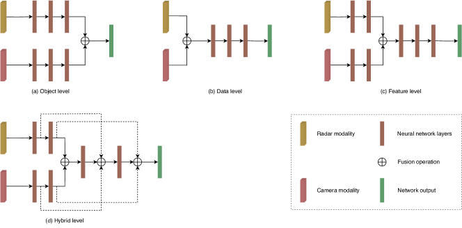
When to fuse refers to at which stage the radar and camera data are fused in the network. Based on the occasion of the fusion process, we classify radar-camera fusion levels into object-level, data-level, feature-level and hybrid-level. Fig. 7 illustrates the overview and difference between the four fusion levels.
IV-D1 Object-level Fusion
For object-level fusion (also known as decision-level fusion or late-level fusion), the independent objects acquired from the radar and camera sensors are fused at a later stage of the network to obtain the final integrated results, as demonstrated in Fig. 7(a). In object-level fusion, how to match the results from the two different modalities is worth considering. One way is to calculate the similarity (e.g., location, size, category) and then employ methods such as the Kalman filter, Bayesian theory, Hungarian algorithm and Bipartite Matching to match the outputs. Another approach involves utilizing the transformation matrix between the radar and camera to determine the position relationships between the two modalities. For example, Jha et al. [209] projected the radar detections onto the image plane using the transformation matrix, and then aligned independent detection objects from the two sensors. Moreover, after completing the association of radar point clouds with camera images, Dong et al. [200] proposed AssociationNet for learning the semantic representation information from the two sensors. This network improves the accuracy of association by calculating and minimizing Euclidean distance between the representations from the pair of radar point clouds and image bounding boxes.
Object-level fusion is commonly used in conventional radars and cameras, which offers high flexibility and modularity [210]. However, it also relies heavily on the accuracy of outputs from individual modules. For example, in scenarios where the camera sensor is obstructed, object-level fusion exclusively depends on the final objects detected by the radar sensor. Besides, rich intermediate features are discarded due to the sensing modality’s weaknesses or errors in the sensors. As a result, object-level fusion methods can only utilize limited information obtained from the detection results.
IV-D2 Data-level Fusion
For data-level fusion (also referred to as low-level fusion or early-level fusion), the raw data or pre-processing data from radar and camera sensors are fused at the early stage of deep learning models, illustrated in Fig. 7(b). Nobis et al. [211] fed the concatenated camera and radar point clouds into the network and then employed VGG [212] to extract features from the combined data. Moreover, Bansa et al. [202] created a Semantic-Point-Grid (SPG) representation from camera semantic maps, radar point clouds and radar BEV grid maps. In their method, the SPG representation is then fed into SPG encoding to extract semantic information from cameras, aiding in the identification of radar points associated with objects of interest. Instead of fusing radar point clouds with camera images, Nabati and Qi [9] proposed an RRPN, which generates object proposals to narrow the scope of detection on the camera images. However, if there is no radar point on an object, this object will be ignored. To solve the difficulty of associating radar point clouds with image pixels, Long et al. [213] presented Radar-Camera Pixel Depth Association (RC-PDA), a learned method that associates radar point clouds with nearby image pixels to enhance and densify the radar image.
With the input of raw data, it is possible to exploit complete characteristics and learn a joint representation from these two modalities. However, data-level fusion methods tend to be sensitive to temporal or spatial misalignment within the data. Precise external calibration of the two sensors is essential for data-level fusion. Besides, as radar data representations are not consistent with the object’s shape, it is difficult to match the radar tensors or radar point clouds with the image pixels.
IV-D3 Feature-level Fusion
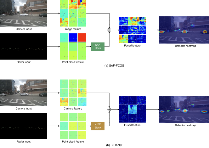
In feature-level fusion (also called middle-level fusion), features extracted from separate radar data and camera images are combined at an intermediate stage in deep learning-based fusion networks, as shown in Fig. 7(c). In [186], features from both radar and camera branches are generated by ResNet [99] blocks and then fused by concatenation and addition operations. CenterFusion [18] detects objects by locating their center points in the image using CenterNet [189]. After that, it utilizes a frustum-based association strategy to accurately match radar detections with objects in the image, generating radar-based feature maps to augment the image features. SAF-FCOS [214] introduces the attention mechanism for weighting different positions of the feature maps. Specifically, it utilizes a Spatial Attention Fusion (SAF) block to merge the feature maps from radar and camera. In the SAF block, the radar image’s feature maps are encoded as a spatial attention weight matrix, which is then applied to all channels to re-weight the feature maps extracted by the camera sensor. BIRANet [190] uses Concurrent Spatial and Channel Squeeze & Excitation (scSE) blocks [216] to highlight important spatial features and significant channels. The scSE block acts as attention and adaptively boosts activation of areas where radar point clouds are present while suppressing activation at other locations. This boosted feature map is then fused with the image feature map to improve the performance of the detection network. Considering feature maps that provide enhanced spatial and channel-wise information, BIRANet exhibits the capability to detect small objects that SAF fails to identify, as illustrated by the detector heatmaps shown in Figure 8. In fact, attention maps can be generated from various sensors. Bijelic et al. [53] extended the sensors to RGB camera, gated camera, LiDAR and radar by transforming all sensor data into uniform image coordinates. The feature maps of different sensors are then superimposed together by concatenation and multiplied with the sigmoid-processed entropy map for the final feature output.
For feature-level fusion, it is possible to design appropriate feature extractors for each modality according to its specific characteristics. Neural networks can also learn features jointly across modalities, making them complementary to each other. However, it is worth noting that feature extraction and feature fusion do not address scenarios where camera sensors become unreliable [210].
IV-D4 Hybrid-level Fusion
Apart from equally fusing final objects, raw data or features from two modalities, some fusion methods combine different stages of data, which we define as hybrid-level fusion, shown in Fig. 7(d). In [194], radar proposals are first generated from radar point clouds and 3D anchors derived from camera images. Then a Radar Proposal Refinement (RPR) network is proposed to fuse the radar proposals with camera image features, which enables the adjustment of the size and location of the radar proposals in the image. Besides, the RPR network also estimates an objectness score for each radar proposal, as some radar point clouds are caused by background noise. Similarly, Cui et al. [195] generated proposals based on camera images and radar BEV point clouds, followed by projecting the proposals onto three feature maps from camera images, radar BEV point clouds and radar FV point clouds. A Self-Supervised Model Adaptation (SSMA) block [217] is utilized to fuse the proposals with features, which leverages an attention scheme for better correlation. Furthermore, HRFuser [218] introduces ideas from HRNet [134] and HRFormer [219], adopting an asymmetric Multi-Window Cross-Attention (MWCA) to fuse the features captured by the RGB camera, LiDAR, radar and gated camera.
Compared with data-level and feature-level fusion, fusion from both proposals and features leads to more accurate proposals, producing better features for the two-stage network [194, 195]. Generally, different modalities have different contributions to radar-camera fusion. One modality dominates, while the other provides supplementary information to refine the features. Thus, hybrid-level fusion takes advantage of different data levels and effectively preserves information at various stages. However, hybrid-level fusion should consider the importance of different modalities, which also pose implementation challenges. Since most implementations of hybrid-level fusion are based on experience and lack explainability to some extent, conducting numerous ablation experiments is needed to validate the efficiency of hybrid-level fusion. Moreover, models based on hybrid-level fusion typically have more branches in neural networks, dramatically slowing down the inference time.
IV-E How to Fuse
In this section, we present how to fuse radar data with camera images. First of all, the primary consideration is the temporal and spatial alignment between the two sensors. Then, in fusion operations, we compare five operations and analyze their advantages and disadvantages.
IV-E1 Data Alignment
Temporal Alignment
Temporal alignment in sensor fusion refers to synchronizing the temporal sequences of data from different sensors. To obtain high-quality fusion results, the data collected by each sensor must be synchronized with the same time dimension. However, there may be time offsets between these sensors due to the differences in set-up time, crystal oscillator frequencies and measurement latency. Depending on the object of the temporal alignment methods, we categorize them into two types: estimating temporal latency between sensors and estimating temporal offset within the same frame.
Estimating Temporal Latency: Generally, temporal latency consists of the measurement latency between sensors and the drift between different frames. Measurement latency mainly stems from computer scheduling, measurement acquisition, pre-processing, and communication transfer time. In aligning cycle time, drift is caused by the offset between the internal clock and the Coordinated Universal Time (UTC).
A software-based technique for reducing temporal error is periodically estimating the maximum measurement latency and drift time [220, 221, 222]. Another alternative approach is to predict the future latency between sensors using Kalman filters [223] or Bayesian estimation [224] based on prior knowledge of the sensors’ latency. These methods improve the synchronization result and are suitable for most applications. Since trigger signals for sensors are not initiated simultaneously, there inevitably remains some degree of unknown latency, which can cause variations in acquisition times during data fusion. Thus, some researchers proposed solutions by combining a hardware controller trigger with the software strategy to reduce the execution time of activation threads in software [225, 226, 227]. These approaches communicate with hardware synchronization components at a low level to eliminate the data acquisition latency. However, standard commercial hardware often lacks hardware synchronization interfaces [228]. When using such methods, the complexity and portability of the system design should be considered.
Estimating Temporal Offset: As the temporal offset between sensors directly affects the fusion quality, some studies proposed temporal calibration strategies based on aligning the same objects from camera and radar sensors to extract timestamp offset. For example, Du et al. [229] aligned the frames that a vehicle passes the detection line and then estimated the temporal offset between these two frames. Moreover, some researchers [230, 231, 211] suggested employing real-time pre-processing buffers that leverage algorithms like YOLOv3 [77] and DBSCAN [232] to reorganize the same frame.
Spatial Alignment
Spatial alignment between radar and camera sensors involves transformation operations that map 3D or 2D radar point clouds to camera image pixels. As the spatial calibration between radar and camera is a fundamental task for information fusion, several methods of joint calibration have been proposed. Among these approaches, whether a specially designed calibration target is needed in the calibration process is an important indicator, leading to different calibration design strategies.
Target-based Approaches: For target-based calibration approaches, specific calibration targets are utilized so that sensors can get precise locations of the target. These locations estimate the rigid transformation relations between the radar and camera sensors. The triangular corner reflector is the most common choice for radar calibration, reflecting specific RCS values for the positional information. Moreover, to obtain positions of the calibrated targets from both the radar sensor and camera sensor, some novel designed calibration boards are proposed. For example, a corner reflector and a styrofoam board are combined as the calibration target in [233, 234]. The styrofoam board is applied for visual recognition in camera sensors without affecting the radar signals. Wang et al. [233] designed a calibration board consisting of a styrofoam board with four holes and a corner reflector in the center of these holes. The Perspective-n-Point (PnP) [235] algorithm is then used to extract the 3D location of holes and estimate the location of the corner reflector. Moreover, Peršić et al. [234] introduced a calibration board consisting of a corner reflector and a styrofoam triangle adorned with a checkerboard, from which both radar and camera sensors can obtain accurate target positional readings. Based on the paired set of image pixels and radar points for the same targets in different locations, the transformation matrix between the radar coordinates and camera coordinates is calculated.
Target-less Approaches: On the other hand, target-less calibration approaches do not rely on specific checkerboards, thus improving the portability of calibration. However, the uncertainty of environmental factors when extracting the same features from multiple sensors is a common drawback in target-less calibration methods. Some researchers utilize precise radar velocity measurements based on the moving objects and the camera pose to implement radar-to-camera extrinsic calibration algorithms [236, 237, 238, 234, 239]. Besides, machine learning algorithms are also utilized in [240, 241, 233, 242] to predict calibration parameters based on improving the consistency of radar point clouds and camera images.
IV-E2 Fusion Operations
In radar-camera fusion, different fusion operations are used to fuse data from the two modalities. Specifically, for object-level and data-level fusion networks, a transformation matrix is commonly used to align final objects or raw data [209, 243]. In contrast, feature-level and hybrid-level fusion networks tend to utilize addition and concatenation operations. In the addition operation, element-wise features in the feature maps are added. Thus, each channel in the feature map contains more feature information, making the classifier comprehend the feature details. Similarly to the addition operation, the mean and multiplication operations calculate the average mean and multiplication of the element-wise feature maps, respectively. In the concatenation operation, the feature maps are flattened into vectors and then concatenated along the rows. The primary objective of the concatenation operation is to enrich feature diversity, enabling the classifier to recognize objects with higher accuracy.
Given that the features of radars and cameras are heterogeneous, and the above fusion operations are sensitive to changes in the input data, the effectiveness of the modalities in particular scenarios is ignored. For example, the performance of the camera sensor tends to reduce in adverse weather conditions, while the radar sensor continues to work properly. Thus, the attention operation is proposed to re-calculate the weights of the feature maps from two modalities. One example of such an approach is Spatial Attention Fusion (SAF), proposed by Chang et al. [214]. SAF extracts the spatial attention matrix from the radar images and then employs it to re-weight the feature maps from the image branch. Other approaches leverage the Mixture of Expert (MoE) [244, 245] to extract feature maps from respective expert networks and calculate the attention weights by a gating network. After that, based on these weights, the feature maps are re-assigned to optimize fusion performance.
IV-F Network Architectures
Generally, networks for radar-camera fusion are structured with dual input branches, where the data from radar and camera is input separately. Depending on the desired fusion stage, raw data, feature maps or final objects are fused in the designed network for fusion results. Based on the representations of radar data, we classify the radar-camera fusion networks in object detection and semantic segmentation tasks into point-based and tensor-based networks. We also provide a chronological overview of radar-camera fusion algorithms in Fig. 9, and summarize the comparable contents in Table LABEL:tab:fusion_methods.
IV-F1 Point-based Networks
Point-based Networks take radar point clouds as input. According to the different radar point cloud processing methods, we subdivide the point-based methods into projection-based, pseudo-image-based, voxel-based and BEV-based methods.
Projection-based Methods: In point-based radar-camera fusion networks, radar point clouds are mostly projected onto the 2D image plane to provide proposals or features. Then networks such as VGG [212], ResNet [99], U-Net [133], YOLOv3 [77] and YOLOv4 [78] are used for feature extraction. Chadwick et al. [186] projected the radar point clouds onto the camera plane and generated two kinds of radar images: range image and range-rate image. Then they integrated an additional radar input branch upon the SSD [83] network, and used both concatenation and element-wise addition operations to fuse the radar features after the image block. The branch structure exhibits potential flexibility in re-calculating weights between the camera image and radar representations. Besides, Meyer and Kuschk [175] generated a BEV image with six height maps and one density map from the point clouds of each frame. The authors also proposed a 3D region proposal network based on VGG [212] to predict the position of boxes and the front angle of the detected object. RVNet [28], a one-stage object detection network based on the YOLOv3 [77], contains two input branches for radar and camera, and two output branches for small obstacles and big obstacles. Specifically, radar point clouds are transformed into sparse radar images in the image coordinate system via the intrinsic matrix from the camera sensor. Each sparse radar image consists of three channels, namely depth, lateral velocity and longitudinal velocity. Based on RVNet [28], SO-Net [199] is presented, focusing on multi-task learning within a single network. In RVNet, the two output branches are modified for vehicle detection and free-space segmentation. CRF-Net [211] projects the radar point clouds onto the image plane and feeds the concatenated camera and radar data into a designed VGG-based network. This network enables learning which layer fusion would yield the best benefits by adjusting the weights to radar features on different layers. In fact, particular objects in camera images tend to remain undetected in night-time scenarios, even when using standard object detection frameworks like YOLOv3 [77]. YOdar [197] involves lowering the score threshold and assigning radar point clouds to image slices, which are then combined through an aggregated output. Finally, a gradient-boosting classifier is employed to minimize the number of false positive predictions, improving the detection accuracy at night conditions.
In conclusion, projection-based methods in point-based processing leverage radar-to-image projection techniques and various deep learning networks for feature extraction. By leveraging techniques such as radar image generation, multi-stage fusion, and network adaptation, these methods enable robust perception and scene understanding in complex environments, thereby advancing the field of radar-camera fusion networks.
Pseudo-Image-based Methods: Since image-based CNN networks cannot directly learn original radar point clouds, some studies convert radar point clouds into radar pseudo-images and then utilize image-based methods to extract features. Based on the distant object detection method in [186], Chang et al. [214] proposed a radar pseudo-image generation model. Apart from transforming radar point clouds from 3D coordinates into 2D camera coordinates, they also converted the depth, longitudinal velocity and lateral velocity to a real pixel value in RGB channels. Then they introduced a Spatial Attention Fusion-based Fully Convolutional One-Stage (SAF-FCOS) network using a SAF block to merge feature maps derived from radar and camera sensors. In the SAF block, features of radar images are encoded as a spatial attention weight matrix, which is employed to re-weight the feature maps from the image branch. SeeingThroughFog [53] introduces a measurement entropy to fuse features from multiple sensors adaptively. Specifically, it applies convolution and sigmoid to the input entropy for a multiplication matrix. The matrix is then utilized to scale the concatenated features from different sensors. This approach adaptively fuses features in the feature extraction stack with the most accurate information. In CenterFusion [18], a novel frustum-based radar association method is proposed to correlate radar detections with preliminary image results. Notably, the authors generated a heat map using depth and radial velocity channels to produce complementary features for the image. After that, they fed the concatenated features into the regression heads to refine the preliminary detection by re-calculating the object’s depth, rotation, velocity and attributes. Finally, the results from the regression heads are decoded into 3D bounding boxes.
Overall, pseudo-image-based methods in point-based radar point cloud processing involve the transformation of radar point clouds into radar pseudo-images, which are then processed using image-based techniques. These methods utilize innovative approaches such as spatial attention mechanisms, adaptive feature fusion based on measurement entropy, and frustum-based radar association to enhance the accuracy and robustness of detection results.
Voxel-based Methods: Apart from projecting radar point clouds onto the camera plane and transforming them into pseudo-images, some researchers extract features directly from 3D radar point clouds to complement the image features. This approach exploits the rich information from the radar point clouds, but requires more sophisticated processing techniques to handle the high-dimensional and unstructured nature of the data. In GRIF Net [245], an FPN [74] and a Sparse Block Network (SBNet) [246] are used as radar backbones to achieve superior performance with low computational resources. Specifically, in point cloud processing, GRIF Net converts point clouds into voxels. As the point clouds are sparse and most voxels are empty, it leverages SBNet to convolve only on masked areas, avoiding ineffective blank areas. In the fusion module, RoI features from image and radar feature maps are combined by convolutional MoE, demonstrating the effectiveness of radar sensors in detecting vehicles at longer distances than cameras. In LXL [247], the 4D radar branch produces 3D radar occupancy grids that indicate the occupancy status of radar point clouds. These 3D radar occupancy grids are leveraged together with predicted image depth maps to assist in the transformation of image perspective features to the BEV domain. This integration method effectively aligns image features with radar BEV representations, enabling effective fusion with radar features.
Above all, voxel-based methods in point-based radar point cloud processing extract features directly from 3D radar point clouds. These methods utilize techniques such as voxelization, sparse convolution, and occupancy grids to handle the high-dimensional and unstructured nature of radar data. By integrating radar features with image features, these methods demonstrate improved performance in detecting vehicles, especially at longer distances and in scenarios where camera data may be limited. The voxel-based approach allows for effective fusion and alignment of information between radar and camera modalities.
BEV-based Methods: Recently, architectures utilizing BEV representations and transformer networks exhibited impressive performance. Simple-BEV [203] focuses on BEV maps from multiple cameras and radars. This method generates a 3D volume with features by projecting 3D coordinates around the ego-vehicle camera images and bilinearly sampling features at projected locations. Later, a BEV feature map is produced by concatenating the 3D features with a rasterized radar image. CRAFT [248] refines image proposals by radar point clouds via a Spatio-Contextual Fusion Transformer (SCFT). The SCFT aims to leverage cross-attention layers to exchange spatial and contextual information in BEV, enabling the fusion network to learn where and what information should be extracted from camera and radar modalities. MVFusion [249] employs multi-view camera images to obtain semantic-aligned radar features, and subsequently integrates these features in a robust fusion transformer to optimize the cross-modal information interaction. CRN [250] introduces multi-modal deformable attention to tackle the spatial misalignment between radar and camera feature maps. With its aggregated semantic features and accurate BEV representations, CRN [250] currently ranks first among all radar-camera fusion detectors in the nuScenes [5] dataset, being the best approach in 3D radar-camera fusion. RCFusion [251] achieves multi-modal feature fusion under a unified BEV perspective with the input of 4D radar and camera. The Interactive Attention Module (IAM), a key component of RCFusion, is utilized to weight the features of each modality, thus fully exploiting the advantages of both modalities.
In summary, BEV-based methods in point-based radar point cloud processing leverage BEV representations and transformer networks to achieve impressive performance in radar-camera fusion. These methods incorporate techniques such as refining proposals, cross-modal information interaction, semantic alignment, and attention mechanisms to optimize feature extraction and fusion between radar and camera data. With the ability to handle spatial misalignment and exploit the advantages of top-down perspective, BEV-based methods demonstrate high performance in 3D radar-camera fusion tasks.
IV-F2 Tensor-based Networks
Due to the potential loss of crucial information concerning objects or the surrounding environment during the processing of radar point clouds after CFAR detection, several researchers have put forward a fusion scheme that involves the fusion of radar tensors with camera images. We categorize these tensor-based networks into cross-supervised-based methods and projection-based methods.
Cross-Supervised-based Methods: For radar data in the format of tensors, it is challenging to label the radar data as they are not spatially consistent compared to image data. Thus, some researchers propose cross-modal supervision methods to generate radar labels with the supervision of camera images. Specifically, RODNet [17, 170] is a radar object detection network using a camera-radar fusion strategy to cross-supervised 3D localization of detected objects during the training stage. It takes sequences of RA tensors as input and uses a neural network-based approach to extract the Doppler information. Specifically, to handle multi-chirp merging information and dynamic object motion, RODNet introduces two customized modules, namely M-Net and Temporal Deformable Convolution (TDC). Moreover, Gao et al. [104] fed sequences of RD tensor, RA tensor and AD tensor into convolutional autoencoders. They proposed a Radar Multiple-Perspectives Convolutional Neural Network (RAMP-CNN) that utilizes the temporal information in the chirps within a single frame, along with the change in spatial information between frames. In RAMP-CNN, features of these three tensors are then fused in a fusion module to generate new range-azimuth features. Compared to RODNet [17, 170], RAMP-CNN achieves significant performance and maintains the same detection accuracy in night scenes as in the daytime. Recently, Jin et al. [252] utilized the segmented camera image with radar customized adaption as the ground truth for training deep neural networks to perform panoptic segmentation on radar data. The proposed network utilizes panoptic segmentation to achieve radar-tailored sensing, including free-space segmentation and object detection, with only radar RA tensor in urban, rural, and highway scenarios.
In conclusion, cross-supervised-based methods enable radar data to benefit from the rich spatial information available in camera data. Techniques like RODNet, RAMP-CNN, and cross-supervised panoptic segmentation have demonstrated the effectiveness of incorporating multi-modal supervision techniques to enhance object detection and segmentation tasks, thus showing performance improvements in handling the unique characteristics and challenges of radar data.
Projection-based Methods: FusionNet [206] converts both radar RA tensors and camera images into Cartesian coordinates, followed by projecting camera images onto the radar plane using a homography transformation. Upon passing through the independent feature extractor branches, features of the two modalities are passed through the additional fusion layers to form a unified feature map. As it is challenging to fuse radar tensors and camera images in 3D coordinates, Hwang et al. [253] proposed a radar-camera matching network named CramNet. CramNet overcomes the uncertainties in the geometric correspondences between the camera and radar through a ray-constrained cross-attention mechanism. Specifically, since a peak in the radar returns usually accompanies the optimal 3D position corresponding to the foreground pixel of an image, CramNet projects radar features along the pixel rays to estimate the depth and refine the 3D locations of camera pixels. Experiments on the RADIATE [168] dataset demonstrate that the CramNet outperforms the baseline results from the Faster R-CNN [73] detector. Additionally, by conducting experiments on the filtering of RA tensors via varying intensity thresholds, radar RA tensors prove to contain more meaningful information for 3D object detection than sparse point clouds.
To sum up, projection-based fusion methods, such as FusionNet and CramNet, offer practical solutions for integrating radar and camera data by leveraging geometric transformations and novel attention mechanisms. These methods contribute to advancing the integration of multi-modal information and demonstrate promising results in object detection tasks, highlighting the significance of leveraging radar tensors in perception systems.
IV-G Model Evaluations
IV-G1 Evaluation Metrics
Various evaluation metrics are adopted or newly proposed to evaluate the performance of radar-camera fusion models, as summarized in Table LABEL:tab:evaluation_metrics. Similar to image-based object detection and semantic segmentation tasks, in radar-camera fusion, commonly used evaluation metrics are precision, recall, Average Precision (AP), Average Recall (AR), mean Average Precision (mAP) and mean Intersection over Union (mIoU). However, these metrics only calculate the prediction accuracy on a given test dataset. Attributes in multi-modal datasets, such as velocity, range, size and orientation, are ignored. Besides, for multi-modal networks, the IoU thresholds should depend on object distance and occlusion, as well as the type of sensors [3].
To overcome these drawbacks, the nuScenes [5] dataset introduces mATE, mASE, mAOE, mAVE and mAAE, which stand for mean average translation, scale, orientation, velocity and attribute errors, respectively. Furthermore, they presented nuScenes Detection Score (NDS), half based on the mAP, half quantifying the previous five metrics. To evaluate how well a detection result matches the ground truth, Wang et al. [17] defined Object Location Similarity (OLS) that quantifies the correlation between two detections concerning their distance, classes and scale information. Additionally, some metrics designed for LiDAR object detection are also adopted in radar point clouds. For example, Cui et al. [195] utilized Average Heading Similarity (AHS) to calculate the accuracy, which is formulated initially to calculate the average orientation angle in 3D LiDAR IoU defined in AVOD [7].
IV-G2 Performance Evaluation
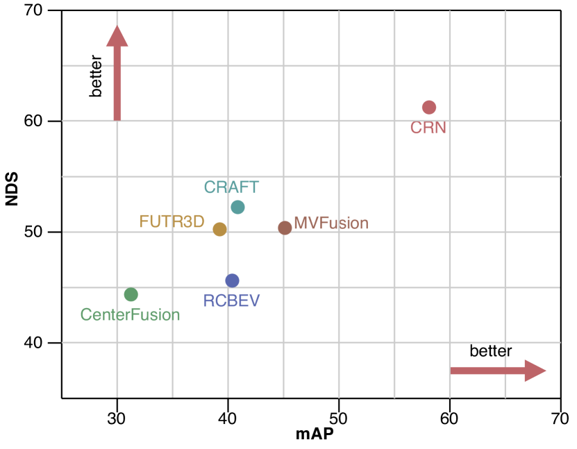
Given that the majority of researchers have employed the nuScenes [5], VoD [34] and TJ4DRadSet [176] datasets to evaluate the performance of their algorithms, we provide a comprehensive summary of the evaluation metrics and performance outcomes on these dataset in Table LABEL:tab:evaluation. We also provide Fig. 10 to clearly show the performance comparison of radar-camera fusion methods using the complete nuScenes dataset. CenterFusion [18], the first radar-camera fusion algorithm to operate on the complete nuScenes dataset, achieves a performance outcome of 32.6% on the mAP and 44.9% on the NDS. CenterFusion solved the critical data association problem in radar-camera fusion by proposing a novel frustum-based radar association method, which generates a RoI frustum around objects in 3D space using preliminary detection results, and maps the radar detection to the center of objects on the image. In comparison to CenterNet [254], which solely relies on image input, CenterFusion delivers a relative increase of 38.1% and 62.1% on the NDS and velocity error metrics, respectively, demonstrating the effectiveness of using radar features and robustness of radar-camera fusion in challenging environments.
After that, numerous radar-camera fusion algorithms employ CenterFusion as the baseline. For example, RCBEV [207], a feature-level fusion approach, extracts radar features using a temporal-spatial encoder and transforms image features into BEV representations. Experimental results demonstrate superior feature representation and more accurate 3D object detection outcomes, receiving the mAP and NDS of 40.6% and 48.6%, respectively. CRAFT [248] achieves 41.1% mAP and 52.3% NDS on the nuScenes, where most of the gain in performance originates from the improved localization and velocity estimation with the assistance of the spatio-contextual fusion transformer. This transformer exploits both spatial and contextual properties of camera and radar data to detect objects in 3D space more accurately. CRN [250] currently emerges as the top-performing detector among all radar-camera fusion algorithms on the nuScenes dataset with 57.5% mAP and 62.4% NDS, being the best approach in 3D radar-camera fusion. The performance gain of the proposed CRN framework comes from its Radar-assisted View Transformation (RVT), which overcomes the lack of spatial information in an image and transforms perspective view image features to BEV with the help of sparse but accurate radar points. The transformed image features in BEV are then used in the Multi-modal Feature Aggregation (MFA) layers to generate a semantically rich and spatially accurate BEV representation. For 4D radar-camera fusion, LXL [247] has 56.31% mAP and 36.32% mAP, ranks first in the VoD and TJ4DRadSet dataset, respectively, being the best approach for 4D radar-camera fusion.
In general, substantial progress has been made by various algorithms operating on radar-camera fusion datasets. The mAP has improved by 24.9%, and the NDS has increased by 17.5% on the complete nuScenes dataset. On the other hand, the mAP has improved by 18.31% on the VoD dataset. The incorporation of transformer architectures, attention mechanisms, and BEV features are crucial factors that have significantly contributed to enhancing performance outcomes.
IV-H Summary
Above all, we present the methodologies of radar-camera fusion related to object detection and semantic segmentation tasks. Through in-depth analysis of the five questions revolving around “why to fuse”, “what to fuse”, “where to fuse”, “when to fuse” and “how to fuse”, we gain insight into the positive benefits of radar-camera fusion when applied on autonomous driving vehicles, including improved accuracy, robustness and redundancy. As indicated by the summary information in Table LABEL:tab:fusion_methods, the number of methods designed for semantic segmentation tasks is fewer than that for the object detection task. On the one hand, as enumerated in Section III-A and Table LABEL:tab:datasets, there are fewer public datasets with segmentation annotations than those with detection annotations available for radar-camera fusion. On the other hand, the intrinsic characteristics of radar data render it more suitable for detection tasks. For example, the capacity for long-distance detection and velocity measurement confers a distinct advantage upon radar data for the effective detection of moving obstacles [186]. Conversely, the sparse and noisy point cloud structure presents significant limitations for semantic segmentation tasks [38].
It is important to note that although radar is not conventionally used for semantic segmentation tasks, it can effectively improve the accuracy and reliability of the fused data [202]. By providing complementary information, such as depth information, radar data can enhance the performance of semantic segmentation algorithms. Also, radar data can be employed to localize objects in 3D space, which can validate the 2D output generated by semantic segmentation algorithms. However, simple fusion operations of image and radar (e.g., concatenation) for semantic segmentation can distort the semantic structure of the image, essentially adding noise to the image. As a result, this can detrimentally impact convergence rates, causing slow and suboptimal learning of the segmentation model.
V Challenges and Research Directions
It is a challenging problem to balance the performance of different modalities so that all of them can perform at their best level and thus improve the overall performance. As described in Section I, radar-camera fusion faces numerous challenges. If these challenges are not properly addressed in sensor perception, they may also affect the subsequent tasks such as localization, prediction, planning and control. In this section, we focus on improving the accuracy and robustness of radar-camera fusion, with discussions on the critical challenges and possible research directions from two aspects: multi-modal data and multi-modal fusion.
| Topic | Sub Topic | Challenges | Research Directions |
| Multi-modal Data | Data Quality | • Sparsity • Inaccuracy • Noise | • Leveraging multiple radar frames to enhance the density • Applying 4D radar sensors with higher resolution • Studying distribution of point clouds (e.g., Gaussian distribution) • Denoising based on physical characteristics of radar data |
| Data Diversity | • Small Size • Insufficient Conditions | • Collecting data from adverse conditions • Integrating synthetic data with real-world data • Domain adaptation for model generalization with limited data | |
| Data Synchronization | • High Calibration Requirements • Difficulties in Labeling | • 4D radar-camera calibration • Real-time online calibration and correction • Auto-labeling to reduce manual labeling • Improving labeling efficiency via active learning, domain adaptation, transfer learning, semi-supervised learning | |
| Multi-modal Fusion | Feature Extraction | • Less effective using LiDAR-based or image-based algorithms | • Introducing attention mechanisms • Using Graph Neural Networks to dig deeper into the relationship between sparse point clouds • Applying neural networks to extract radar information instead of traditional FFT operations |
| Data Association | • Ambiguity in associating radar data with image data • Poor association using calibration matrix | • Attention-based association with adaptive thresholds • Joint state estimation • Uncertainty estimation of object tracks | |
| Data Augmentation | • Correlation and interdependence between radar and camera modalities | • Joint data augmentation rather than augmenting each modality separately | |
| Training Strategies | • Difficulties in training • Overfitting for multi-modal model | • Weighting operations on loss functions • Weights freezing strategies • Knowledge distillation on uni-modal features for the multi-modal networks | |
| Model Robustness | • Sensor degradation or failure in adverse conditions • Unseen driving scenarios | • Attention mechanisms • Uncertainty estimation • Generative models for sensor defects or new scenarios | |
| Model Evaluations | • Different selected sub-dataset • Unknown objects in the open world | • Metrics related to uncertainties • Developing visual toolkits for analyzing and optimizing fusion networks | |
| Model Deployment | • Edge devices with limited computational resources • Balancing the importance of different tasks | • Lightweight models and acceleration schemes (e.g., pruning and quantization) • Fusion-based multi-task perception and panoptic perception |
V-A Multi-modal Data
V-A1 Data Quality
Unlike uni-modal data, multi-modal data requires consideration of each modality’s native characteristics. The information within an image is structured and regular, with partial information being associated with the whole image. In contrast, the spatial information embodied in radar point clouds tends to be disordered. As a result, handling radar data poses a more significant challenge in the context of radar-camera fusion. We categorize these challenges related to data quality into three directions: sparsity, inaccuracy, and noise.
Sparsity
The sparsity of radar point clouds poses a challenge for neural networks to learn features effectively. Besides, as these point clouds do not comprehensively represent an object’s shape, a fixed-size bounding box approach would be impractical. To address the issue of sparsity, researchers usually combine multiple frames (from 0.25 seconds to 1 second) of radar data to get denser point clouds, making it conducive to improving accuracy [38, 211, 18, 245, 213, 34, 203]. However, the time-dependent approach also causes system delays. Nowadays, the 4D radar sensor is a potential research direction as it produces denser point clouds, reaching hundreds of points on a car. The spatial distribution of objects is effectively represented in 4D radar datasets, including Astyx [175], VoD [34] and TJ4DRadSet [176]. Experiments also indicate that the 4D radar is helpful in radar detection. For example, Zheng et al. [176] proved that 4D radar has potential in 3D perception as the points get dense. Palffy et al. [34] pointed out that the additional elevation data increases object detection performance (from 31.9% to 38.0% in mAP) in their VoD [34] dataset.
Inaccuracy
Aside from the sparsity of radar point clouds, the points may not be located at the object’s center, but may be at any corner of the object or even outside of it [175]. To make the radar points located on or close to the object, Chadwick et al. [186] marked each radar point on the image as a small circle instead of a single pixel. Nabati and Qi [9] proposed RRPN to generate several anchors with different sizes and aspect ratios centered at the points of interest. These translated anchors are employed to achieve more precise bounding boxes where the points of interest are mapped to the object’s right, left, or bottom.
Researchers have employed column and pillar expansion techniques to improve the accuracy of radar point clouds in the vertical dimension. For example, Nobis et al. [211] assumed a height extension of three meters on each radar detection to associate camera pixels with radar data. Nabati and Qi [18] used pillar expansion to expand each radar point to a fixed-size pillar. In their experiment, the size of a pillar is set to meters along the directions. Notably, the column size should be different for different types of objects. In [196], the authors utilized a clustering approach to group ground truth bounding boxes of vehicles into three distinct height categories. Following this, radar points are assigned a scale based on boundary edge values in each category.
In our opinion, column or pillar expansion is effective but still hardly convincing. The distribution of point clouds is a direction worth investigating. For example, Stäcker et al. [255] assumed a Gaussian distribution to measure the azimuth angle. According to the resulting Gaussian density curve, they generated denser radar point clouds, horizontally distributed over multiple pixels.
Noise
Actually, the radar sensor returns noisy data from irrelevant objects, including ghost objects, ground detections and even multi-radar mutual interference [256]. The noise from radars could cause the detection of fake targets, thereby limiting the accuracy of radar-based detection or segmentation.
Conventional methods [257, 258, 259, 260] for automotive radar denoising are typically based on CFAR and peak detection algorithms, which exhibit poor generalization capabilities. Recently, deep learning methods have provided a key solution to the challenges associated with automotive radar data denoising. In [261], a deep neural network is proposed to enhance the target peaks on RA tensors. Rock et al. [262] analyzed the quantization of CNN-based denoising autoencoder for radar interference mitigation on radar RD tensors to guarantee real-time inference on low-performance equipment. Dubey et al. [263] realized the multi-radar mutual interference and object detection on RD tensors simultaneously with one one-stage CNN-based neural network. Moreover, in [264, 265, 266, 267, 268], fully-convolution networks are widely proposed and applied to interference mitigation on RD tensors.
However, conventional radars generally do not provide access to the radar tensor, highlighting the importance of noise mitigation techniques at the level of radar point clouds. For example, Nobis et al. [211] designed a ground-truth filter to remove radar detections outside of the 3D ground truth bounding boxes. Cheng et al. [269] proposed a cross-modal radar point detector through the assistance of LiDAR, which could also remove the noisy points. Essentially, noise mitigation at the point cloud level is semantic segmentation of the point cloud, whereby a semantic segmentation model is leveraged to assign a category to each point. Numerous studies focus on point cloud segmentation, including PointMLP [270], PointNeXt [271], Point Transformer [272] and Point Cloud Transformer [273]. Notably, Point Transformer and Point Cloud Transformer introduce the self-attention mechanism within their point cloud processing networks to capture contextual features. However, it is worth noting that these approaches still rely on the advantages provided by two essential modules derived from PointNet++: Set Abstraction (SA) and Multi-Scale Grouping (MSG). Recently, a revolutionary non-parametric point cloud segmentation model called Point-NN has been proposed. Point-NN [274] elegantly assembles farthest point sampling, K nearest neighbor, pooling, trigonometric position encodings and similarity measurement, thereby achieving SOTA performances on several benchmarks with superior performance to any other point cloud processing models.
In all, regardless of the stage of denoising in radar tensors or point clouds, a dataset with high-quality annotations is necessary. For the noise removal on radar tensors, researchers may adopt image denoising and restoration principles. For removing noisy point clouds, constructing features based on the physical characteristics of point clouds to guide models separate targets from clutters makes sense. As radar point clouds are sparse and inaccurate, modeling the inherent uncertainty is an open question, which can aid in effectively distinguishing targets from noise.
V-A2 Data Diversity
Small Size
Deep learning models rely on large amounts of training data to achieve high levels of accuracy. However, multi-modal datasets consisting of both radar and camera data are much smaller than uni-modal image data. For instance, compared to the ImageNet [275, 276] dataset with over 14 million images and over 20k classes, the largest radar-camera fusion dataset to date named CRUW [170] has only 400k frames and 260k objects. Furthermore, regarding category distribution, most labels are vehicles, while pedestrians and bicycles are far less prevalent. The imbalance in these categories’ distribution may result in overfitting designed deep learning networks [158].
Insufficient Conditions
In real scenarios, 360-degree perception of the surrounding environment is critical in autonomous driving, requiring multiple cameras and radars to work together. Besides, the multi-modal dataset also needs to consider complex weather conditions (e.g., rain, fog, snow) and complex road conditions (e.g., blocked roads, rural paths, intersections), all of which are time-consuming and labor-consuming tasks.
Some studies [169, 180] generate synthetic data via simulation tools (e.g., Carla [181]). Researchers can freely match different sensors and generate different driving conditions with these tools, especially in complex and dangerous scenarios. However, it is also worth noting that although simulators can generate a variety of virtual datasets, the simulated data cannot completely replace the data from real scenarios. Moreover, exploring the appropriate methodology for integrating synthetic data with real-world data is a critical area of inquiry warranting further investigation [277].
Domain adaptation is also a valuable research direction that aims to leverage knowledge learned from a related domain with adequate labeled data. Although domain adaptation has been applied in radar data, including radar tensor reconstruction [278], human sensing [279], human activity recognition [280] and gesture recognition [281], it has not been employed in radar-camera fusion till now.
V-A3 Data Synchronization
High Calibration Requirements
For radar-camera fusion systems, well-calibrated sensors are the prerequisite. In multi-sensor calibration, LiDAR sensors are typically employed as an essential intermediary component. The LiDAR sensor is calibrated separately from the camera sensor and radar sensor, and then a transformation matrix between the radar and camera can be calculated [176, 173]. Although numerous approaches (e.g., [282, 195, 283]) are proposed for calibration between radars and the cameras, the accuracy of the calibration remains a challenge due to the inaccurate and vulnerable radar returns. Besides, as far as we know, [195] and [177] are the only methods for 4D radar and camera calibration. As 4D radar technologies are developing rapidly, we believe that 4D radar calibration is a potential direction, and more finds will be proposed in the future.
In real scenarios, extrinsic calibration parameters between radar and camera sensors may change from vehicle vibration. Besides, different sampling frequencies of the radar and camera may produce a particular temporal difference between the data from each sensor. The temporal difference would cause data inconsistency, especially when the ego-car or targets move at high speed. Therefore, real-time online calibration and correction are essential research directions in the future.
Difficulties in Labeling
The process of labeling data is labor-intensive and time-consuming, especially when dealing with multi-modal data. This is particularly true for radar-camera fusion, where the physical shapes of objects cannot be discerned directly from the radar data representation. Auto-labeling radar data is a potential research direction to address the challenge of laborious data labeling. Actually, labels for radar data can be calculated based on the corresponding ground truth from camera images and the extrinsic matrix between the radar sensor and the camera sensor. But the problem is that applying this labeling approach for radar data is not perfect, as radar targets may not always be located in the ground truth from images. Sengupta et al. [284] proposed a camera-aided method for automatically labeling radar point clouds, leveraging a pre-trained YOLOv3 [77] network and the Hungarian algorithm for enhanced accuracy and efficiency. However, despite the potential advantages of auto-labeling radar data, filtering out noisy data around the object of interest is still challenging.
For camera image labeling, it is worth considering how to select appropriate labeling data for reducing labor costs. Active learning is a supervised learning method that aims to select the smallest possible training set to achieve the desired data efficiency [285, 286]. The active learning network iteratively queries the most informative samples from the human labelers in an unlabeled data pool and then updates the weights for the network. This approach leads to equivalent performance with less labeled training data, reducing human labeling efforts. Experiments from [287] indicate that using only about 40% of the data in the training set leads to the same classification results as the completely supervised reference experiment. Furthermore, many other methods would also be used to reduce the burden of data labeling, such as domain adaptation [288, 289, 278], transfer learning [290], semi-supervised learning [291] and lifelong learning [292].
V-B Multi-modal Fusion
V-B1 Feature Extraction
Applying LiDAR-based feature extraction algorithms to radar modality is less effective due to the inherent sparsity of radar point clouds. As an example, PointPillars [293] algorithm converts LiDAR point clouds into pillars and then extracts features from each pillar. When this algorithm is adapted to radar point clouds, there may be few or even no points in a pillar, which makes it hard to extract features. In fact, results in [108] and [294] also indicate that the average precision of radar point clouds using PointPillars [293] is much lower than using SSD [83] and YOLOv3 [77] detectors.
As PointPillars [293] focus on local features, the attention mechanism is a potential research direction to extract global features to improve accuracy. For example, Radar Transformer [295] incorporates both vector attention and scalar attention mechanisms to effectively leverage spatial information, Doppler information, and reflection intensity information from radar point clouds. By integrating local attention features and global attention features, Radar Transformer achieves deep integration of radar information. RPFA-Net [296] leverages the self-attention mechanism to extract global features (e.g., orientation) from point clouds. These global features enable the network to perform more efficient and effective regression of key object parameters (e.g., heading angle), thereby enhancing the accuracy and reliability of object detection. In addition, Gaussian Radar Transformer [161] employs attentive upsampling and downsampling modules to enlarge the receptive field and capture distinctive spatial correlations, effectively addressing the challenge of capturing long-range dependencies in radar data. The attention-based techniques and multi-task learning used in HARadNet [109] also lead to a significant performance improvement in the classification and detection.
To dig deeper into the relationship between sparse point clouds, GNN [297] is a promising research direction in which each point is considered as a node, and edges are the relationship between the points. In Radar-PointGNN [98], GNN adopted for feature extraction of radar point clouds demonstrates that the graph representation produces more effective object proposals than other point cloud encoders by mapping radar point clouds to contextual representations. RadarGNN [39] indicates that GNNs can operate on unstructured and unordered data, obtaining both point features and point-pair features embedded in the edges of the graph. Thus, compared to voxelization operations, GNN eliminates the information loss from the sparse radar point clouds. GNN also shows its advantages in detection from RA tensors. The Graph Tensor Radar Network (GTR-Net) [298] architecture utilizes graph convolutional operations to aggregate information across the point cloud nodes. The process involves weighting the features of connected nodes based on their respective edge weights. In this way, it improves the defective sparse points by aggregating relevant information and thus leads to better performance.
Another potential research opportunity is using neural networks to extract radar information instead of traditional FFT operations, which can reduce the computational requirements that consume most of the operations and simplify the data flow in the embedded implementation. For example, in RODNet [17], FFT operations are only performed in sample and antenna dimensions, while the chirp dimension remains to get the range-azimuth-chirp tensor. Then a neural network is employed to process the chirp dimension for extracting Doppler features, enabling end-to-end training of radar features in-depth within the deep learning framework.
V-B2 Data Association
Another significant challenge is the ambiguity in associating radar data with image data, as they are heterogeneous. The typical way is to project radar data onto the image plane and then bind the data in the same position through a calibration matrix [299]. However, direct projection results in poor association with the objects’ centers. As aforementioned, radar data is sparse, inaccurate and noisy, making poor association at either the object-level or data-level fusion.
Thus, associating image data with radar data is an open question. Nabati and Qi [194] proposed a Radar Proposal Refinement (RPR) network to match proposals from radars and cameras. Later, they integrated the detection boxes and pillar expansion through frustum association in CenterFusion [18], allowing for the mapping of radar detections to the centers of objects and mitigating the issue of overlapping. Dong et al. [200] used AssociationNet to learn the semantic representation information and associate radar point clouds and image bounding boxes by Euclidean distance. For associating the semantics to radar point clouds, Bansal et al. [202] proposed a representation named Semantic-Point-Grid (SPG), which encodes semantic information from camera images into radar point clouds to identify camera pixel correspondences for each radar point.
In our opinion, a potential approach to associate radar data with image data is the attention-based association with adaptive thresholds. For example, Radar-Camera Pixel Depth Association (RC-PDA) is proposed to filter out occluded radar returns and enhance the projected radar depth map by generating a confidence measure for these associations in [213]. Soft Polar Association (SPA) is proposed to associate radar point clouds around the image proposals in polar coordinates [248]. In order to overcome background clutter, it utilized consecutive cross attention-based encoder layers to integrate image proposal features and radar point features.
V-B3 Data Augmentation
Numerous data augmentation methods have been proposed to increase the quantity and diversity of data samples, thus preventing network overfitting and enhancing model generalization. For radar data in the form of point clouds, data augmentations such as random rotation, scaling, and flipping shifting are applied to enrich the diversity of samples in [18, 176, 207]. In addition, since radar tensors can be treated as images, existing image-based data augmentation algorithms (e.g., horizontal flipping, translating in range, interpolating, mixing) are tested in experiments and proved to be effective [104].
However, all these data augmentation methods above are based only on the radar modality. In radar-camera fusion perception, designing effective data augmentation methods needs to consider the correlation and interdependence between radar and camera modalities, which means joint data augmentation methods are necessary rather than augmenting each modality separately. Otherwise, the model will learn from incorrect data, whose physical properties are unreliable. For example, when the coordinates of radar data and image are aligned, applying Cutmix [300] on the image and radar feature maps will undoubtedly destroy the target features (e.g., azimuth and elevation) obtained by the radar sensor, leading to incorrect model inferences. Therefore, designing joint data augmentation algorithms for the unique radar representations combined with image modality remains a significant challenge.
V-B4 Training Strategies
Since a multi-modal network has additional input information, it should match or outperform the uni-modal network. However, this is not always the case. A multi-modal network is often prone to overfitting and tends to learn to ignore one branch if the hyper-parameters set for training are more suitable for the other branch. Wang et al. [301] argued that the rates of overfitting and generalization vary across different modalities, and training a multi-modal network using the uni-modal training strategy may not be optimal for the overall network.
A feasible approach to balance the performance is to add loss functions for each modality. In this way, after one modality converges, the remaining modality can still be generalized. Besides, weighting operations on loss functions could be more beneficial to adapt to the learning rates of each modality. In recent studies, Wang et al. [301] proposed Gradient-Blending, which computes an optimal blending of modalities based on their overfitting behaviors. Although this method achieves SOTA accuracy on audio and vision benchmarks, the idea has yet to be applied in radar and camera modalities. Moreover, dropout operation helps overcome overfitting. Nobis et al. [211] introduced BlackIn by deactivating camera image data. The lack of camera input data forces the network to rely more on sparse radar data for specific potential values.
Fine-tuning a multi-modal network over pre-trained uni-modal encoders can also outperform fusion from scratch. Lim et al. [206] utilized the weights freezing strategy to train a single branch network using the optimal training hyper-parameters. These weights were subsequently loaded into the corresponding branches to train the fusion network. Experimental results indicate that the best strategy is to train the camera branch in advance and then train the entire network with the gradient propagation disabled through the camera branch. Recently, knowledge distillation has shown its performance in multi-modal networks by distilling the pre-trained uni-modal features to the multi-modal networks [302, 303]. It could also be a potential research direction in radar-camera fusion.
V-B5 Model Robustness
Another challenge is how to guarantee the model’s robustness when the sensors are degraded, or the autonomous driving vehicles enter into adverse or unseen driving scenarios. Most reviewed methods focus on the accuracy of public datasets, while only a few consider sensor failure with only one modality as the input data. In RadSegNet [202], the SPG encoding independently extracts information from cameras and radar, as well as encodes semantic information from camera images into radar point clouds. Thus in scenarios where the camera input becomes unreliable, the SPG encoding method maintains reliable operation using radar data alone. Bijelic et al. [53] introduced an entropy channel for each sensor stream and a feature fusion architecture to exchange features, which still work in unseen weather conditions and sensor failures. Moreover, the attention mechanism is also an effective choice for guiding mixed information from different sensors to fuse features of multiple modalities, as well as handle original features from a single modality. For example, attention maps leverage features learned from different sensors to predict the importance of specific parameters in [304].
It is essential to focus not only on the accuracy of the predicted outcomes, but also on the degree of certainty the model has about them. Uncertainty is a potential direction that can be used to handle unseen driving scenarios. Specifically, a multi-modal network should present higher uncertainty against unseen objects. The Bayesian neural network is a valuable choice for calculating uncertainty. It utilizes a prior distribution of network weights to infer the posterior distribution, thereby estimating the probability associated with a given prediction [3, 305]. In radar-camera fusion, YOdar [197] is an uncertainty-based method in which uncertainty combines outputs of radar and camera networks with a gradient-boosting classifier. Experimental results show that YOdar increases performance significantly at night scenes.
Another way that may be useful to increase the networks’ robustness is generative models. They can detect sensor defects or new scenarios an autonomous vehicle has never entered. Wheeler et al. [306] described a methodology for constructing stochastic automotive radar models based on deep learning with adversarial loss connected to real-world data. The resulting model exhibits fundamental radar effects while maintaining real-time capability. Lekic and Babic et al. [307] introduced a Conditional Multi-Generator Generative Adversarial Network (CMGGAN) to generate pseudo-images containing all the surrounding objects detected by the radar sensor. In our opinion, designing specific deep generative models for radar-camera fusion is an interesting open question.
V-B6 Model Evaluations
Most researchers utilize the nuScenes [5] dataset to evaluate the performance of their algorithms. However, the selected sub-dataset and the evaluation metrics are different, leading to a lack of direct comparisons. As summarized in Table LABEL:tab:evaluation, some methods [9, 199, 214, 197, 243] use portions of the nuScenes dataset for training, validating and testing, while some others [28, 194, 245, 255] exploit data collected by part of sensors within the nuScenes dataset. In addition, some researchers [211, 190, 196] do not clarify which section of the nuScenes dataset they utilized in their experiments.
In terms of evaluation metrics, even though some studies provide results using AP and mAP metrics, the type and value of the threshold are different. Besides, only a few works provide information on the inference time, which is also calculated by authors on their own devices and lacks uniform hardware measurements. In our opinion, since the nuScenes [5] dataset has been used to evaluate the performance of major algorithms, researchers should validate the performance of their algorithms on the same IoU, metrics and sub-dataset. This would enable a more meaningful and direct comparison of the results obtained from various studies.
Moreover, standard evaluation metrics are not specifically designed for situations where sensors are defective. Metrics related to uncertainties, such as Probability-based Detection Quality (PDQ) [308], may be helpful in radar-camera fusion to compare the robustness of different algorithms. Radar-camera fusion also faces the challenges of unknown objects in the open world. In such scenarios, evaluation metrics proposed in [309, 310] can be utilized for open-set objects in radar-camera fusion.
Furthermore, visualization evaluation techniques are a potential research direction for analyzing and optimizing radar-camera fusion networks. Several methods [311, 312] have been proposed for interpreting and understanding deep neural networks. However, to the best of our knowledge, there has yet to be an investigation of visual analytics in radar-camera fusion. How to design the visual toolkits for radar-camera fusion networks is still an open and challenging question.
V-B7 Model Deployment
Radar-camera fusion holds significant potential in practical autonomous driving vehicles, where models of radar-camera fusion are deployed on edge devices. Compared with high computational servers, edge devices are often equipped with limited computational resources in memory, bandwidth, Graphics Processing Unit (GPU) and Central Processing Unit (CPU). Nevertheless, they still need to meet the low-latency and high-performance requirements. Currently,[313] is the only work that reports on fusion output speed, reaching 11 Hz on an NVIDIA Jetson AGX TX2. The results of fusion algorithms on edge devices are an open question, and how to improve the computational efficiency is worth considering. Some network acceleration schemes (e.g., pruning and quantization [314, 315]) are good choices to be applied to radar-camera fusion models.
It is valuable to implement multiple tasks in a uni-model for real applications. In multi-task learning, the knowledge learned during training for one task can be shared and used to improve performance on the other tasks [4]. Besides, by sharing model features between multiple tasks, the overall number of parameters and computations can be reduced, making it more efficient in real-time autonomous driving applications [194, 316]. Multi-task in radar-camera fusion is still in the preliminary stage, and we believe the multi-task approach in radar-camera fusion is a potential research direction. Nonetheless, combining multiple tasks into a unified optimization objective results in a complex optimization problem, especially when the tasks are related but have different performance metrics. Finding a set of hyper-parameters that can effectively balance the importance of different tasks is challenging.
VI Conclusion
With the rapid development of autonomous driving, radar-camera fusion, a multi-modal and all-weather solution, is gaining more attention in both academic research and industrial applications. This review investigates and discusses radar-camera fusion studies on object detection and semantic segmentation tasks. Starting with the working principles of radar and camera sensors, we gradually introduce the importance of radar-camera fusion in autonomous driving perception. Through the analysis of radar signal processing, we gain a deep understanding of radar representations, which also provides fundamental support for the radar-camera fusion datasets. As to fusion methodologies, we delve into various fusion methods and explore questions about “why to fuse”, “what to fuse”, “where to fuse”, “when to fuse” and “how to fuse”.
Based on the current radar-camera fusion datasets and methods, we discuss the critical challenges and raise possible research directions involving multi-modal data and multi-modal fusion. In general, radar-camera fusion is moving towards data representations containing rich information. On the one hand, representations such as ADC signals and radar tensors provide more potential information, which is valuable for multi-modal fusion. On the other hand, the new 4D radar sensors provide denser point clouds and higher resolutions, which will become a new trend in autonomous driving. Fusion approaches are evolving towards customizing radar algorithms based on particular radar characteristics. Additionally, methods on multi-frames and multi-tasks in radar-camera fusion are expected in future works. Above all, we hope that our survey serves as a comprehensive reference for researchers and practitioners in developing robust perception in radar-camera fusion.
Acknowledgment
This research was funded by the Suzhou Municipal Key Laboratory for Intelligent Virtual Engineering (SZS2022004), the Key Programme Special Fund of XJTLU (KSF-A-19), the Suzhou Science and Technology Project (SYG202122), the Research Development Fund of XJTLU (RDF-19-02-23) and Jiangsu Engineering Research Center for Data Science and Cognitive Computing. This work received financial support from Jiangsu Industrial Technology Research Institute (JITRI) and Wuxi National Hi-Tech District (WND).
References
- [1] B. Paden, M. Čáp, S. Z. Yong, D. Yershov, and E. Frazzoli, “A survey of motion planning and control techniques for self-driving urban vehicles,” IEEE Transactions on Intelligent Vehicles, vol. 1, no. 1, pp. 33–55, 2016.
- [2] Y. Xiao, F. Codevilla, A. Gurram, O. Urfalioglu, and A. M. López, “Multimodal end-to-end autonomous driving,” IEEE Transactions on Intelligent Transportation Systems, vol. 23, no. 1, pp. 537–547, 2020.
- [3] D. Feng, C. Haase-Schütz, L. Rosenbaum, H. Hertlein, C. Glaeser, F. Timm, W. Wiesbeck, and K. Dietmayer, “Deep multi-modal object detection and semantic segmentation for autonomous driving: Datasets, methods, and challenges,” IEEE Transactions on Intelligent Transportation Systems, vol. 22, no. 3, pp. 1341–1360, 2020.
- [4] M. Liang, B. Yang, Y. Chen, R. Hu, and R. Urtasun, “Multi-task multi-sensor fusion for 3d object detection,” in Proceedings of the IEEE/CVF Conference on Computer Vision and Pattern Recognition, 2019, pp. 7345–7353.
- [5] H. Caesar, V. Bankiti, A. H. Lang, S. Vora, V. E. Liong, Q. Xu, A. Krishnan, Y. Pan, G. Baldan, and O. Beijbom, “nuscenes: A multimodal dataset for autonomous driving,” in Proceedings of the IEEE/CVF conference on computer vision and pattern recognition, 2020, pp. 11 621–11 631.
- [6] X. Chen, H. Ma, J. Wan, B. Li, and T. Xia, “Multi-view 3d object detection network for autonomous driving,” in Proceedings of the IEEE conference on Computer Vision and Pattern Recognition, 2017, pp. 1907–1915.
- [7] J. Ku, M. Mozifian, J. Lee, A. Harakeh, and S. L. Waslander, “Joint 3d proposal generation and object detection from view aggregation,” in 2018 IEEE/RSJ International Conference on Intelligent Robots and Systems (IROS). IEEE, 2018, pp. 1–8.
- [8] B. Li, T. Zhang, and T. Xia, “Vehicle detection from 3d lidar using fully convolutional network,” arXiv preprint arXiv:1608.07916, 2016.
- [9] R. Nabati and H. Qi, “Rrpn: Radar region proposal network for object detection in autonomous vehicles,” in 2019 IEEE International Conference on Image Processing (ICIP). IEEE, 2019, pp. 3093–3097.
- [10] R. Zhang, S. A. Candra, K. Vetter, and A. Zakhor, “Sensor fusion for semantic segmentation of urban scenes,” in 2015 IEEE international conference on robotics and automation (ICRA). IEEE, 2015, pp. 1850–1857.
- [11] R. Yin, Y. Cheng, H. Wu, Y. Song, B. Yu, and R. Niu, “Fusionlane: Multi-sensor fusion for lane marking semantic segmentation using deep neural networks,” IEEE Transactions on Intelligent Transportation Systems, vol. 23, no. 2, pp. 1543–1553, 2020.
- [12] A. Asvadi, P. Girao, P. Peixoto, and U. Nunes, “3d object tracking using rgb and lidar data,” in 2016 IEEE 19th International Conference on Intelligent Transportation Systems (ITSC). IEEE, 2016, pp. 1255–1260.
- [13] Y. Fang, H. Zhao, H. Zha, X. Zhao, and W. Yao, “Camera and lidar fusion for on-road vehicle tracking with reinforcement learning,” in 2019 IEEE Intelligent Vehicles Symposium (IV). IEEE, 2019, pp. 1723–1730.
- [14] K. Yoneda, N. Suganuma, R. Yanase, and M. Aldibaja, “Automated driving recognition technologies for adverse weather conditions,” IATSS research, vol. 43, no. 4, pp. 253–262, 2019.
- [15] P. Li, P. Wang, K. Berntorp, and H. Liu, “Exploiting temporal relations on radar perception for autonomous driving,” in Proceedings of the IEEE/CVF Conference on Computer Vision and Pattern Recognition, 2022, pp. 17 071–17 080.
- [16] B. Major, D. Fontijne, A. Ansari, R. T. Sukhavasi, R. Gowaikar, M. Hamilton, S. Lee, S. Grzechnik, and S. Subramanian, “Vehicle detection with automotive radar using deep learning on range-azimuth-doppler tensors,” in 2019 IEEE/CVF International Conference on Computer Vision Workshop (ICCVW). IEEE, 2019, pp. 924–932.
- [17] Y. Wang, Z. Jiang, Y. Li, J.-N. Hwang, G. Xing, and H. Liu, “Rodnet: A real-time radar object detection network cross-supervised by camera-radar fused object 3d localization,” IEEE Journal of Selected Topics in Signal Processing, vol. 15, no. 4, pp. 954–967, 2021.
- [18] R. Nabati and H. Qi, “Centerfusion: Center-based radar and camera fusion for 3d object detection,” in Proceedings of the IEEE/CVF Winter Conference on Applications of Computer Vision, 2021, pp. 1527–1536.
- [19] E. Arnold, O. Y. Al-Jarrah, M. Dianati, S. Fallah, D. Oxtoby, and A. Mouzakitis, “A survey on 3d object detection methods for autonomous driving applications,” IEEE Transactions on Intelligent Transportation Systems, vol. 20, no. 10, pp. 3782–3795, 2019.
- [20] Y. Cui, R. Chen, W. Chu, L. Chen, D. Tian, Y. Li, and D. Cao, “Deep learning for image and point cloud fusion in autonomous driving: A review,” IEEE Transactions on Intelligent Transportation Systems, vol. 23, no. 2, pp. 722–739, 2021.
- [21] K. Huang, B. Shi, X. Li, X. Li, S. Huang, and Y. Li, “Multi-modal sensor fusion for auto driving perception: A survey,” arXiv preprint arXiv:2202.02703, 2022.
- [22] S. Jusoh and S. Almajali, “A systematic review on fusion techniques and approaches used in applications,” IEEE Access, vol. 8, pp. 14 424–14 439, 2020.
- [23] Z. Wang, Y. Wu, and Q. Niu, “Multi-sensor fusion in automated driving: A survey,” Ieee Access, vol. 8, pp. 2847–2868, 2019.
- [24] Z. Wei, F. Zhang, S. Chang, Y. Liu, H. Wu, and Z. Feng, “Mmwave radar and vision fusion for object detection in autonomous driving: A review,” Sensors, vol. 22, no. 7, p. 2542, 2022.
- [25] C. Iovescu and S. Rao, “The fundamentals of millimeter wave sensors,” Texas Instruments, pp. 1–8, 2017.
- [26] R. Appleby and R. N. Anderton, “Millimeter-wave and submillimeter-wave imaging for security and surveillance,” Proceedings of the IEEE, vol. 95, no. 8, pp. 1683–1690, 2007.
- [27] P. Fritsche, S. Kueppers, G. Briese, and B. Wagner, “Radar and lidar sensorfusion in low visibility environments.” in ICINCO (2), 2016, pp. 30–36.
- [28] V. John and S. Mita, “Rvnet: Deep sensor fusion of monocular camera and radar for image-based obstacle detection in challenging environments,” in Image and Video Technology: 9th Pacific-Rim Symposium, PSIVT 2019, Sydney, NSW, Australia, November 18–22, 2019, Proceedings 9. Springer, 2019, pp. 351–364.
- [29] Y. Long, D. Morris, X. Liu, M. Castro, P. Chakravarty, and P. Narayanan, “Full-velocity radar returns by radar-camera fusion,” in Proceedings of the IEEE/CVF International Conference on Computer Vision, 2021, pp. 16 198–16 207.
- [30] Y. Li, J. Deng, Y. Zhang, J. Ji, H. Li, and Y. Zhang, “Ezfusion: A close look at the integration of lidar, millimeter-wave radar, and camera for accurate 3d object detection and tracking,” IEEE Robotics and Automation Letters, vol. 7, no. 4, pp. 11 182–11 189, 2022.
- [31] H. Griffiths, L. Cohen, S. Watts, E. Mokole, C. Baker, M. Wicks, and S. Blunt, “Radar spectrum engineering and management: Technical and regulatory issues,” Proceedings of the IEEE, vol. 103, no. 1, pp. 85–102, 2014.
- [32] J. Kopp, D. Kellner, A. Piroli, and K. Dietmayer, “Tackling clutter in radar data–label generation and detection using pointnet++,” arXiv preprint arXiv:2303.09530, 2023.
- [33] A. Ouaknine, A. Newson, J. Rebut, F. Tupin, and P. Pérez, “Carrada dataset: Camera and automotive radar with range-angle-doppler annotations,” in 2020 25th International Conference on Pattern Recognition (ICPR). IEEE, 2021, pp. 5068–5075.
- [34] A. Palffy, E. Pool, S. Baratam, J. F. Kooij, and D. M. Gavrila, “Multi-class road user detection with 3+ 1d radar in the view-of-delft dataset,” IEEE Robotics and Automation Letters, vol. 7, no. 2, pp. 4961–4968, 2022.
- [35] D. Gusland, J. M. Christiansen, B. Torvik, F. Fioranelli, S. Z. Gurbuz, and M. Ritchie, “Open radar initiative: Large scale dataset for benchmarking of micro-doppler recognition algorithms,” in 2021 IEEE Radar Conference (RadarConf21). IEEE, 2021, pp. 1–6.
- [36] F. E. Nowruzi, D. Kolhatkar, P. Kapoor, F. Al Hassanat, E. J. Heravi, R. Laganiere, J. Rebut, and W. Malik, “Deep open space segmentation using automotive radar,” in 2020 IEEE MTT-S International Conference on Microwaves for Intelligent Mobility (ICMIM). IEEE, 2020, pp. 1–4.
- [37] B. Yang, I. Khatri, M. Happold, and C. Chen, “Adcnet: End-to-end perception with raw radar adc data,” arXiv preprint arXiv:2303.11420, 2023.
- [38] O. Schumann, M. Hahn, J. Dickmann, and C. Wöhler, “Semantic segmentation on radar point clouds,” in 2018 21st International Conference on Information Fusion (FUSION). IEEE, 2018, pp. 2179–2186.
- [39] F. Fent, P. Bauerschmidt, and M. Lienkamp, “Radargnn: Transformation invariant graph neural network for radar-based perception,” in Proceedings of the IEEE/CVF Conference on Computer Vision and Pattern Recognition, 2023, pp. 182–191.
- [40] H. Rohling, “Radar cfar thresholding in clutter and multiple target situations,” IEEE transactions on aerospace and electronic systems, no. 4, pp. 608–621, 1983.
- [41] P. P. Gandhi and S. A. Kassam, “Analysis of cfar processors in nonhomogeneous background,” IEEE Transactions on Aerospace and Electronic systems, vol. 24, no. 4, pp. 427–445, 1988.
- [42] K. Werber, M. Rapp, J. Klappstein, M. Hahn, J. Dickmann, K. Dietmayer, and C. Waldschmidt, “Automotive radar gridmap representations,” in 2015 IEEE MTT-S International Conference on Microwaves for Intelligent Mobility (ICMIM). IEEE, 2015, pp. 1–4.
- [43] L. Sless, B. El Shlomo, G. Cohen, and S. Oron, “Road scene understanding by occupancy grid learning from sparse radar clusters using semantic segmentation,” in Proceedings of the IEEE/CVF International Conference on Computer Vision Workshops, 2019, pp. 0–0.
- [44] O. Schumann, J. Lombacher, M. Hahn, C. Wöhler, and J. Dickmann, “Scene understanding with automotive radar,” IEEE Transactions on Intelligent Vehicles, vol. 5, no. 2, pp. 188–203, 2019.
- [45] J. Lombacher, M. Hahn, J. Dickmann, and C. Wöhler, “Detection of arbitrarily rotated parked cars based on radar sensors,” in 2015 16th International Radar Symposium (IRS). IEEE, 2015, pp. 180–185.
- [46] S. Chen, W. He, J. Ren, and X. Jiang, “Attention-based dual-stream vision transformer for radar gait recognition,” in ICASSP 2022-2022 IEEE International Conference on Acoustics, Speech and Signal Processing (ICASSP). IEEE, 2022, pp. 3668–3672.
- [47] Wikipedia contributors, “Image sensor — Wikipedia, the free encyclopedia,” 2023, [Online; accessed 10-April-2023]. [Online]. Available: https://en.wikipedia.org/w/index.php?title=Image_sensor&oldid=1146373856
- [48] C. Michaelis, B. Mitzkus, R. Geirhos, E. Rusak, O. Bringmann, A. S. Ecker, M. Bethge, and W. Brendel, “Benchmarking robustness in object detection: Autonomous driving when winter is coming,” arXiv preprint arXiv:1907.07484, 2019.
- [49] X. Xu, Y. Ma, and W. Sun, “Towards real scene super-resolution with raw images,” in Proceedings of the IEEE/CVF Conference on Computer Vision and Pattern Recognition, 2019, pp. 1723–1731.
- [50] X. Liu, K. Shi, Z. Wang, and J. Chen, “Exploit camera raw data for video super-resolution via hidden markov model inference,” IEEE Transactions on Image Processing, vol. 30, pp. 2127–2140, 2021.
- [51] H. Song, W. Choi, and H. Kim, “Robust vision-based relative-localization approach using an rgb-depth camera and lidar sensor fusion,” IEEE Transactions on Industrial Electronics, vol. 63, no. 6, pp. 3725–3736, 2016.
- [52] S. Inbar and O. David, “Laser gated camera imaging system and method,” May 27 2008, uS Patent 7,379,164.
- [53] M. Bijelic, T. Gruber, F. Mannan, F. Kraus, W. Ritter, K. Dietmayer, and F. Heide, “Seeing through fog without seeing fog: Deep multimodal sensor fusion in unseen adverse weather,” in Proceedings of the IEEE/CVF Conference on Computer Vision and Pattern Recognition, 2020, pp. 11 682–11 692.
- [54] G. Gallego, T. Delbrück, G. Orchard, C. Bartolozzi, B. Taba, A. Censi, S. Leutenegger, A. J. Davison, J. Conradt, K. Daniilidis et al., “Event-based vision: A survey,” IEEE transactions on pattern analysis and machine intelligence, vol. 44, no. 1, pp. 154–180, 2020.
- [55] F. Rosique, P. J. Navarro, C. Fernández, and A. Padilla, “A systematic review of perception system and simulators for autonomous vehicles research,” Sensors, vol. 19, no. 3, p. 648, 2019.
- [56] S. Saponara and B. Neri, “Radar sensor signal acquisition and multidimensional fft processing for surveillance applications in transport systems,” IEEE Transactions on Instrumentation and Measurement, vol. 66, no. 4, pp. 604–615, 2017.
- [57] S. Sun, A. P. Petropulu, and H. V. Poor, “Mimo radar for advanced driver-assistance systems and autonomous driving: Advantages and challenges,” IEEE Signal Processing Magazine, vol. 37, no. 4, pp. 98–117, 2020.
- [58] B. Li, “3d fully convolutional network for vehicle detection in point cloud,” in 2017 IEEE/RSJ International Conference on Intelligent Robots and Systems (IROS). IEEE, 2017, pp. 1513–1518.
- [59] X. Chen, K. Kundu, Z. Zhang, H. Ma, S. Fidler, and R. Urtasun, “Monocular 3d object detection for autonomous driving,” in Proceedings of the IEEE conference on computer vision and pattern recognition, 2016, pp. 2147–2156.
- [60] S. Zhang, R. Benenson, M. Omran, J. Hosang, and B. Schiele, “Towards reaching human performance in pedestrian detection,” IEEE transactions on pattern analysis and machine intelligence, vol. 40, no. 4, pp. 973–986, 2017.
- [61] L. Zhang, L. Lin, X. Liang, and K. He, “Is faster r-cnn doing well for pedestrian detection?” in Computer Vision–ECCV 2016: 14th European Conference, Amsterdam, The Netherlands, October 11-14, 2016, Proceedings, Part II 14. Springer, 2016, pp. 443–457.
- [62] X. Chen, K. Kundu, Y. Zhu, H. Ma, S. Fidler, and R. Urtasun, “3d object proposals using stereo imagery for accurate object class detection,” IEEE transactions on pattern analysis and machine intelligence, vol. 40, no. 5, pp. 1259–1272, 2017.
- [63] M. Weber, P. Wolf, and J. M. Zöllner, “Deeptlr: A single deep convolutional network for detection and classification of traffic lights,” in 2016 IEEE intelligent vehicles symposium (IV). IEEE, 2016, pp. 342–348.
- [64] J. Müller and K. Dietmayer, “Detecting traffic lights by single shot detection,” in 2018 21st International Conference on Intelligent Transportation Systems (ITSC). IEEE, 2018, pp. 266–273.
- [65] M. Bach, S. Reuter, and K. Dietmayer, “Multi-camera traffic light recognition using a classifying labeled multi-bernoulli filter,” in 2017 IEEE Intelligent Vehicles Symposium (IV). IEEE, 2017, pp. 1045–1051.
- [66] K. Behrendt, L. Novak, and R. Botros, “A deep learning approach to traffic lights: Detection, tracking, and classification,” in 2017 IEEE International Conference on Robotics and Automation (ICRA). IEEE, 2017, pp. 1370–1377.
- [67] Z. Zhu, D. Liang, S. Zhang, X. Huang, B. Li, and S. Hu, “Traffic-sign detection and classification in the wild,” in Proceedings of the IEEE conference on computer vision and pattern recognition, 2016, pp. 2110–2118.
- [68] H. S. Lee and K. Kim, “Simultaneous traffic sign detection and boundary estimation using convolutional neural network,” IEEE Transactions on Intelligent Transportation Systems, vol. 19, no. 5, pp. 1652–1663, 2018.
- [69] H. Luo, Y. Yang, B. Tong, F. Wu, and B. Fan, “Traffic sign recognition using a multi-task convolutional neural network,” IEEE Transactions on Intelligent Transportation Systems, vol. 19, no. 4, pp. 1100–1111, 2017.
- [70] R. Girshick, J. Donahue, T. Darrell, and J. Malik, “Rich feature hierarchies for accurate object detection and semantic segmentation,” in Proceedings of the IEEE conference on computer vision and pattern recognition, 2014, pp. 580–587.
- [71] K. He, X. Zhang, S. Ren, and J. Sun, “Spatial pyramid pooling in deep convolutional networks for visual recognition,” IEEE Transactions on Pattern Analysis and Machine Intelligence, vol. 37, no. 9, pp. 1904–1916, 2015.
- [72] R. Girshick, “Fast r-cnn,” in Proceedings of the IEEE international conference on computer vision, 2015, pp. 1440–1448.
- [73] S. Ren, K. He, R. Girshick, and J. Sun, “Faster r-cnn: Towards real-time object detection with region proposal networks,” Advances in neural information processing systems, vol. 28, 2015.
- [74] T.-Y. Lin, P. Dollár, R. Girshick, K. He, B. Hariharan, and S. Belongie, “Feature pyramid networks for object detection,” in Proceedings of the IEEE conference on computer vision and pattern recognition, 2017, pp. 2117–2125.
- [75] J. Redmon, S. Divvala, R. Girshick, and A. Farhadi, “You only look once: Unified, real-time object detection,” in Proceedings of the IEEE conference on computer vision and pattern recognition, 2016, pp. 779–788.
- [76] J. Redmon and A. Farhadi, “Yolo9000: better, faster, stronger,” in Proceedings of the IEEE conference on computer vision and pattern recognition, 2017, pp. 7263–7271.
- [77] J. Redmon and A. Farhadi, “Yolov3: An incremental improvement,” arXiv preprint arXiv:1804.02767, 2018.
- [78] A. Bochkovskiy, C.-Y. Wang, and H.-Y. M. Liao, “Yolov4: Optimal speed and accuracy of object detection,” arXiv preprint arXiv:2004.10934, 2020.
- [79] G. Jocher, “YOLOv5 by Ultralytics,” 5 2020. [Online]. Available: https://github.com/ultralytics/yolov5
- [80] C. Li, L. Li, H. Jiang, K. Weng, Y. Geng, L. Li, Z. Ke, Q. Li, M. Cheng, W. Nie et al., “Yolov6: A single-stage object detection framework for industrial applications,” arXiv preprint arXiv:2209.02976, 2022.
- [81] C.-Y. Wang, A. Bochkovskiy, and H.-Y. M. Liao, “Yolov7: Trainable bag-of-freebies sets new state-of-the-art for real-time object detectors,” in Proceedings of the IEEE/CVF Conference on Computer Vision and Pattern Recognition, 2023, pp. 7464–7475.
- [82] G. Jocher, A. Chaurasia, and J. Qiu, “YOLO by Ultralytics,” Jan. 2023. [Online]. Available: https://github.com/ultralytics/ultralytics
- [83] W. Liu, D. Anguelov, D. Erhan, C. Szegedy, S. Reed, C.-Y. Fu, and A. C. Berg, “Ssd: Single shot multibox detector,” in Computer Vision–ECCV 2016: 14th European Conference, Amsterdam, The Netherlands, October 11–14, 2016, Proceedings, Part I 14. Springer, 2016, pp. 21–37.
- [84] T.-Y. Lin, P. Goyal, R. Girshick, K. He, and P. Dollár, “Focal loss for dense object detection,” in Proceedings of the IEEE international conference on computer vision, 2017, pp. 2980–2988.
- [85] N. Carion, F. Massa, G. Synnaeve, N. Usunier, A. Kirillov, and S. Zagoruyko, “End-to-end object detection with transformers,” in European conference on computer vision. Springer International Publishing Cham, 2020, pp. 213–229.
- [86] X. Zhu, W. Su, L. Lu, B. Li, X. Wang, and J. Dai, “Deformable detr: Deformable transformers for end-to-end object detection,” arXiv preprint arXiv:2010.04159, 2020.
- [87] W. Lv, S. Xu, Y. Zhao, G. Wang, J. Wei, C. Cui, Y. Du, Q. Dang, and Y. Liu, “Detrs beat yolos on real-time object detection,” 2023.
- [88] F. Liu, H. Wei, W. Zhao, G. Li, J. Peng, and Z. Li, “Wb-detr: transformer-based detector without backbone,” in Proceedings of the IEEE/CVF International Conference on Computer Vision, 2021, pp. 2979–2987.
- [89] Z. Liu, Y. Lin, Y. Cao, H. Hu, Y. Wei, Z. Zhang, S. Lin, and B. Guo, “Swin transformer: Hierarchical vision transformer using shifted windows,” in Proceedings of the IEEE/CVF international conference on computer vision, 2021, pp. 10 012–10 022.
- [90] Y. Fang, B. Liao, X. Wang, J. Fang, J. Qi, R. Wu, J. Niu, and W. Liu, “You only look at one sequence: Rethinking transformer in vision through object detection,” Advances in Neural Information Processing Systems, vol. 34, pp. 26 183–26 197, 2021.
- [91] Z. Peng, W. Huang, S. Gu, L. Xie, Y. Wang, J. Jiao, and Q. Ye, “Conformer: Local features coupling global representations for visual recognition,” in Proceedings of the IEEE/CVF international conference on computer vision, 2021, pp. 367–376.
- [92] J. Pan, A. Bulat, F. Tan, X. Zhu, L. Dudziak, H. Li, G. Tzimiropoulos, and B. Martinez, “Edgevits: Competing light-weight cnns on mobile devices with vision transformers,” in European Conference on Computer Vision. Springer Nature Switzerland Cham, 2022, pp. 294–311.
- [93] S. Mehta and M. Rastegari, “Mobilevit: light-weight, general-purpose, and mobile-friendly vision transformer,” arXiv preprint arXiv:2110.02178, 2021.
- [94] Y. Xu, Q. Zhang, J. Zhang, and D. Tao, “Vitae: Vision transformer advanced by exploring intrinsic inductive bias,” Advances in neural information processing systems, vol. 34, pp. 28 522–28 535, 2021.
- [95] Z. Chen, L. Xie, J. Niu, X. Liu, L. Wei, and Q. Tian, “Visformer: The vision-friendly transformer,” in Proceedings of the IEEE/CVF international conference on computer vision, 2021, pp. 589–598.
- [96] A. Palffy, J. Dong, J. F. Kooij, and D. M. Gavrila, “Cnn based road user detection using the 3d radar cube,” IEEE Robotics and Automation Letters, vol. 5, no. 2, pp. 1263–1270, 2020.
- [97] A. Zhang, F. E. Nowruzi, and R. Laganiere, “Raddet: Range-azimuth-doppler based radar object detection for dynamic road users,” in 2021 18th Conference on Robots and Vision (CRV). IEEE, 2021, pp. 95–102.
- [98] P. Svenningsson, F. Fioranelli, and A. Yarovoy, “Radar-pointgnn: Graph based object recognition for unstructured radar point-cloud data,” in 2021 IEEE Radar Conference (RadarConf21). IEEE, 2021, pp. 1–6.
- [99] K. He, X. Zhang, S. Ren, and J. Sun, “Deep residual learning for image recognition,” in Proceedings of the IEEE conference on computer vision and pattern recognition, 2016, pp. 770–778.
- [100] X. Gao, G. Xing, S. Roy, and H. Liu, “Experiments with mmwave automotive radar test-bed,” in 2019 53rd Asilomar conference on signals, systems, and computers. IEEE, 2019, pp. 1–6.
- [101] X. Dong, P. Wang, P. Zhang, and L. Liu, “Probabilistic oriented object detection in automotive radar,” in Proceedings of the IEEE/CVF Conference on Computer Vision and Pattern Recognition Workshops, 2020, pp. 102–103.
- [102] W. Ng, G. Wang, Z. Lin, B. J. Dutta et al., “Range-doppler detection in automotive radar with deep learning,” in 2020 International Joint Conference on Neural Networks (IJCNN). IEEE, 2020, pp. 1–8.
- [103] C. Decourt, R. VanRullen, D. Salle, and T. Oberlin, “Darod: A deep automotive radar object detector on range-doppler maps,” in 2022 IEEE Intelligent Vehicles Symposium (IV). IEEE, 2022, pp. 112–118.
- [104] X. Gao, G. Xing, S. Roy, and H. Liu, “Ramp-cnn: A novel neural network for enhanced automotive radar object recognition,” IEEE Sensors Journal, vol. 21, no. 4, pp. 5119–5132, 2020.
- [105] J. Rebut, A. Ouaknine, W. Malik, and P. Pérez, “Raw high-definition radar for multi-task learning,” in Proceedings of the IEEE/CVF Conference on Computer Vision and Pattern Recognition, 2022, pp. 17 021–17 030.
- [106] A. Danzer, T. Griebel, M. Bach, and K. Dietmayer, “2d car detection in radar data with pointnets,” in 2019 IEEE Intelligent Transportation Systems Conference (ITSC). IEEE, 2019, pp. 61–66.
- [107] J. F. Tilly, S. Haag, O. Schumann, F. Weishaupt, B. Duraisamy, J. Dickmann, and M. Fritzsche, “Detection and tracking on automotive radar data with deep learning,” in 2020 IEEE 23rd International Conference on Information Fusion (FUSION). IEEE, 2020, pp. 1–7.
- [108] N. Scheiner, F. Kraus, F. Wei, B. Phan, F. Mannan, N. Appenrodt, W. Ritter, J. Dickmann, K. Dietmayer, B. Sick et al., “Seeing around street corners: Non-line-of-sight detection and tracking in-the-wild using doppler radar,” in Proceedings of the IEEE/CVF Conference on Computer Vision and Pattern Recognition, 2020, pp. 2068–2077.
- [109] A. Dubey, A. Santra, J. Fuchs, M. Lübke, R. Weigel, and F. Lurz, “Haradnet: Anchor-free target detection for radar point clouds using hierarchical attention and multi-task learning,” Machine Learning with Applications, vol. 8, p. 100275, 2022.
- [110] B. Tan, Z. Ma, X. Zhu, S. Li, L. Zheng, S. Chen, L. Huang, and J. Bai, “3d object detection for multi-frame 4d automotive millimeter-wave radar point cloud,” IEEE Sensors Journal, 2022.
- [111] C. R. Qi, H. Su, K. Mo, and L. J. Guibas, “Pointnet: Deep learning on point sets for 3d classification and segmentation,” in Proceedings of the IEEE conference on computer vision and pattern recognition, 2017, pp. 652–660.
- [112] C. R. Qi, L. Yi, H. Su, and L. J. Guibas, “Pointnet++: Deep hierarchical feature learning on point sets in a metric space,” Advances in neural information processing systems, vol. 30, 2017.
- [113] C. R. Qi, W. Liu, C. Wu, H. Su, and L. J. Guibas, “Frustum pointnets for 3d object detection from rgb-d data,” in Proceedings of the IEEE conference on computer vision and pattern recognition, 2018, pp. 918–927.
- [114] M. Dreher, E. Erçelik, T. Bänziger, and A. Knoll, “Radar-based 2d car detection using deep neural networks,” in 2020 IEEE 23rd International Conference on Intelligent Transportation Systems (ITSC). IEEE, 2020, pp. 1–8.
- [115] D. Köhler, M. Quach, M. Ulrich, F. Meinl, B. Bischoff, and H. Blume, “Improved multi-scale grid rendering of point clouds for radar object detection networks,” arXiv preprint arXiv:2305.15836, 2023.
- [116] J. Liu, Q. Zhao, W. Xiong, T. Huang, Q.-L. Han, and B. Zhu, “Smurf: Spatial multi-representation fusion for 3d object detection with 4d imaging radar,” arXiv preprint arXiv:2307.10784, 2023.
- [117] Y. Zhou and O. Tuzel, “Voxelnet: End-to-end learning for point cloud based 3d object detection,” in Proceedings of the IEEE conference on computer vision and pattern recognition, 2018, pp. 4490–4499.
- [118] S. Tsutsui, T. Kerola, and S. Saito, “Distantly supervised road segmentation,” in Proceedings of the IEEE International Conference on Computer Vision Workshops, 2017, pp. 174–181.
- [119] S. Tsutsui, T. Kerola, S. Saito, and D. J. Crandall, “Minimizing supervision for free-space segmentation,” in Proceedings of the IEEE Conference on Computer Vision and Pattern Recognition Workshops, 2018, pp. 988–997.
- [120] Y.-C. Chan, Y.-C. Lin, and P.-C. Chen, “Lane mark and drivable area detection using a novel instance segmentation scheme,” in 2019 IEEE/SICE International Symposium on System Integration (SII). IEEE, 2019, pp. 502–506.
- [121] Y. Qian, J. M. Dolan, and M. Yang, “Dlt-net: Joint detection of drivable areas, lane lines, and traffic objects,” IEEE Transactions on Intelligent Transportation Systems, vol. 21, no. 11, pp. 4670–4679, 2019.
- [122] H. Wang, R. Fan, P. Cai, and M. Liu, “Sne-roadseg+: Rethinking depth-normal translation and deep supervision for freespace detection,” in 2021 IEEE/RSJ International Conference on Intelligent Robots and Systems (IROS). IEEE, 2021, pp. 1140–1145.
- [123] M.-E. Shao, M. A. Haq, D.-Q. Gao, P. Chondro, and S.-J. Ruan, “Semantic segmentation for free space and lane based on grid-based interest point detection,” IEEE Transactions on Intelligent Transportation Systems, vol. 23, no. 7, pp. 8498–8512, 2021.
- [124] J. Kim and C. Park, “End-to-end ego lane estimation based on sequential transfer learning for self-driving cars,” in Proceedings of the IEEE conference on computer vision and pattern recognition workshops, 2017, pp. 30–38.
- [125] D. Neven, B. De Brabandere, S. Georgoulis, M. Proesmans, and L. Van Gool, “Towards end-to-end lane detection: an instance segmentation approach,” in 2018 IEEE intelligent vehicles symposium (IV). IEEE, 2018, pp. 286–291.
- [126] Z. Wang, W. Ren, and Q. Qiu, “Lanenet: Real-time lane detection networks for autonomous driving,” arXiv preprint arXiv:1807.01726, 2018.
- [127] Q. Zou, H. Jiang, Q. Dai, Y. Yue, L. Chen, and Q. Wang, “Robust lane detection from continuous driving scenes using deep neural networks,” IEEE Transactions on Vehicular Technology, vol. 69, no. 1, pp. 41–54, 2019.
- [128] X. Chen, Y. Liu, and K. Achuthan, “Wodis: Water obstacle detection network based on image segmentation for autonomous surface vehicles in maritime environments,” IEEE Transactions on Instrumentation and Measurement, vol. 70, pp. 1–13, 2021.
- [129] B. Bovcon and M. Kristan, “Wasr—a water segmentation and refinement maritime obstacle detection network,” IEEE Transactions on Cybernetics, vol. 52, no. 12, pp. 12 661–12 674, 2021.
- [130] B. Bovcon, J. Muhovič, D. Vranac, D. Mozetič, J. Perš, and M. Kristan, “Mods—a usv-oriented object detection and obstacle segmentation benchmark,” IEEE Transactions on Intelligent Transportation Systems, vol. 23, no. 8, pp. 13 403–13 418, 2021.
- [131] J. Long, E. Shelhamer, and T. Darrell, “Fully convolutional networks for semantic segmentation,” in Proceedings of the IEEE conference on computer vision and pattern recognition, 2015, pp. 3431–3440.
- [132] V. Badrinarayanan, A. Kendall, and R. Cipolla, “Segnet: A deep convolutional encoder-decoder architecture for image segmentation,” IEEE Transactions on Pattern Analysis and Machine Intelligence, vol. 39, no. 12, pp. 2481–2495, 2017.
- [133] O. Ronneberger, P. Fischer, and T. Brox, “U-net: Convolutional networks for biomedical image segmentation,” in Medical Image Computing and Computer-Assisted Intervention–MICCAI 2015: 18th International Conference, Munich, Germany, October 5-9, 2015, Proceedings, Part III 18. Springer, 2015, pp. 234–241.
- [134] Y. Yuan, X. Chen, and J. Wang, “Object-contextual representations for semantic segmentation,” in Computer Vision–ECCV 2020: 16th European Conference, Glasgow, UK, August 23–28, 2020, Proceedings, Part VI 16. Springer, 2020, pp. 173–190.
- [135] L.-C. Chen, G. Papandreou, I. Kokkinos, K. Murphy, and A. L. Yuille, “Semantic image segmentation with deep convolutional nets and fully connected crfs,” arXiv preprint arXiv:1412.7062, 2014.
- [136] L.-C. Chen, G. Papandreou, I. Kokkinos, K. Murphy, and A. L. Yuille, “Deeplab: Semantic image segmentation with deep convolutional nets, atrous convolution, and fully connected crfs,” IEEE Transactions on Pattern Analysis and Machine Intelligence, vol. 40, no. 4, pp. 834–848, 2017.
- [137] L.-C. Chen, G. Papandreou, F. Schroff, and H. Adam, “Rethinking atrous convolution for semantic image segmentation,” arXiv preprint arXiv:1706.05587, 2017.
- [138] L.-C. Chen, Y. Zhu, G. Papandreou, F. Schroff, and H. Adam, “Encoder-decoder with atrous separable convolution for semantic image segmentation,” in Proceedings of the European conference on computer vision (ECCV), 2018, pp. 801–818.
- [139] A. Paszke, A. Chaurasia, S. Kim, and E. Culurciello, “Enet: A deep neural network architecture for real-time semantic segmentation,” arXiv preprint arXiv:1606.02147, 2016.
- [140] H. Zhao, J. Shi, X. Qi, X. Wang, and J. Jia, “Pyramid scene parsing network,” in Proceedings of the IEEE conference on computer vision and pattern recognition, 2017, pp. 2881–2890.
- [141] P. Wang, P. Chen, Y. Yuan, D. Liu, Z. Huang, X. Hou, and G. Cottrell, “Understanding convolution for semantic segmentation,” in 2018 IEEE winter conference on applications of computer vision (WACV). Ieee, 2018, pp. 1451–1460.
- [142] M. Yang, K. Yu, C. Zhang, Z. Li, and K. Yang, “Denseaspp for semantic segmentation in street scenes,” in Proceedings of the IEEE conference on computer vision and pattern recognition, 2018, pp. 3684–3692.
- [143] S. Zheng, J. Lu, H. Zhao, X. Zhu, Z. Luo, Y. Wang, Y. Fu, J. Feng, T. Xiang, P. H. Torr et al., “Rethinking semantic segmentation from a sequence-to-sequence perspective with transformers,” in Proceedings of the IEEE/CVF conference on computer vision and pattern recognition, 2021, pp. 6881–6890.
- [144] R. Strudel, R. Garcia, I. Laptev, and C. Schmid, “Segmenter: Transformer for semantic segmentation,” in Proceedings of the IEEE/CVF international conference on computer vision, 2021, pp. 7262–7272.
- [145] E. Xie, W. Wang, Z. Yu, A. Anandkumar, J. M. Alvarez, and P. Luo, “Segformer: Simple and efficient design for semantic segmentation with transformers,” Advances in Neural Information Processing Systems, vol. 34, pp. 12 077–12 090, 2021.
- [146] H. Yan, C. Zhang, and M. Wu, “Lawin transformer: Improving semantic segmentation transformer with multi-scale representations via large window attention,” arXiv preprint arXiv:2201.01615, 2022.
- [147] B. Cheng, A. Schwing, and A. Kirillov, “Per-pixel classification is not all you need for semantic segmentation,” Advances in Neural Information Processing Systems, vol. 34, pp. 17 864–17 875, 2021.
- [148] A. Ouaknine, A. Newson, P. Pérez, F. Tupin, and J. Rebut, “Multi-view radar semantic segmentation,” in Proceedings of the IEEE/CVF International Conference on Computer Vision, 2021, pp. 15 671–15 680.
- [149] S. T. Isele, F. Klein, M. Brosowsky, and J. M. Zöllner, “Learning semantics on radar point-clouds,” in 2021 IEEE Intelligent Vehicles Symposium (IV). IEEE, 2021, pp. 810–817.
- [150] F. E. Nowruzi, D. Kolhatkar, P. Kapoor, E. J. Heravi, F. A. Hassanat, R. Laganiere, J. Rebut, and W. Malik, “Polarnet: Accelerated deep open space segmentation using automotive radar in polar domain,” arXiv preprint arXiv:2103.03387, 2021.
- [151] J. Lombacher, K. Laudt, M. Hahn, J. Dickmann, and C. Wöhler, “Semantic radar grids,” in 2017 IEEE intelligent vehicles symposium (IV). IEEE, 2017, pp. 1170–1175.
- [152] R. Prophet, G. Li, C. Sturm, and M. Vossiek, “Semantic segmentation on automotive radar maps,” in 2019 IEEE Intelligent Vehicles Symposium (IV). IEEE, 2019, pp. 756–763.
- [153] P. Kaul, D. De Martini, M. Gadd, and P. Newman, “Rss-net: Weakly-supervised multi-class semantic segmentation with fmcw radar,” in 2020 IEEE Intelligent Vehicles Symposium (IV). IEEE, 2020, pp. 431–436.
- [154] I. Orr, M. Cohen, and Z. Zalevsky, “High-resolution radar road segmentation using weakly supervised learning,” Nature Machine Intelligence, vol. 3, no. 3, pp. 239–246, 2021.
- [155] L. Zhang, X. Zhang, Y. Zhang, Y. Guo, Y. Chen, X. Huang, and Z. Ma, “Peakconv: Learning peak receptive field for radar semantic segmentation,” in Proceedings of the IEEE/CVF Conference on Computer Vision and Pattern Recognition, 2023, pp. 17 577–17 586.
- [156] Z. Feng, S. Zhang, M. Kunert, and W. Wiesbeck, “Point cloud segmentation with a high-resolution automotive radar,” in AmE 2019-Automotive meets Electronics; 10th GMM-Symposium. VDE, 2019, pp. 1–5.
- [157] O. Schumann, M. Hahn, J. Dickmann, and C. Wöhler, “Supervised clustering for radar applications: On the way to radar instance segmentation,” in 2018 IEEE MTT-S International Conference on Microwaves for Intelligent Mobility (ICMIM). IEEE, 2018, pp. 1–4.
- [158] F. Nobis, F. Fent, J. Betz, and M. Lienkamp, “Kernel point convolution lstm networks for radar point cloud segmentation,” Applied Sciences, vol. 11, no. 6, p. 2599, 2021.
- [159] J. Liu, W. Xiong, L. Bai, Y. Xia, T. Huang, W. Ouyang, and B. Zhu, “Deep instance segmentation with automotive radar detection points,” IEEE Transactions on Intelligent Vehicles, vol. 8, no. 1, pp. 84–94, 2022.
- [160] R. Prophet, A. Deligiannis, J.-C. Fuentes-Michel, I. Weber, and M. Vossiek, “Semantic segmentation on 3d occupancy grids for automotive radar,” IEEE Access, vol. 8, pp. 197 917–197 930, 2020.
- [161] M. Zeller, J. Behley, M. Heidingsfeld, and C. Stachniss, “Gaussian radar transformer for semantic segmentation in noisy radar data,” IEEE Robotics and Automation Letters, vol. 8, no. 1, pp. 344–351, 2022.
- [162] W. Xiong, J. Liu, Y. Xia, T. Huang, B. Zhu, and W. Xiang, “Contrastive learning for automotive mmwave radar detection points based instance segmentation,” in 2022 IEEE 25th International Conference on Intelligent Transportation Systems (ITSC). IEEE, 2022, pp. 1255–1261.
- [163] A. Geiger, P. Lenz, and R. Urtasun, “Are we ready for autonomous driving? the kitti vision benchmark suite,” in 2012 IEEE conference on computer vision and pattern recognition. IEEE, 2012, pp. 3354–3361.
- [164] W. Maddern, G. Pascoe, C. Linegar, and P. Newman, “1 year, 1000 km: The oxford robotcar dataset,” The International Journal of Robotics Research, vol. 36, no. 1, pp. 3–15, 2017.
- [165] X. Huang, P. Wang, X. Cheng, D. Zhou, Q. Geng, and R. Yang, “The apolloscape open dataset for autonomous driving and its application,” IEEE Transactions on Pattern Analysis and Machine Intelligence, vol. 42, no. 10, pp. 2702–2719, 2019.
- [166] P. Sun, H. Kretzschmar, X. Dotiwalla, A. Chouard, V. Patnaik, P. Tsui, J. Guo, Y. Zhou, Y. Chai, B. Caine et al., “Scalability in perception for autonomous driving: Waymo open dataset,” in Proceedings of the IEEE/CVF conference on computer vision and pattern recognition, 2020, pp. 2446–2454.
- [167] M. Mostajabi, C. M. Wang, D. Ranjan, and G. Hsyu, “High-resolution radar dataset for semi-supervised learning of dynamic objects,” in Proceedings of the IEEE/CVF Conference on Computer Vision and Pattern Recognition Workshops, 2020, pp. 100–101.
- [168] M. Sheeny, E. De Pellegrin, S. Mukherjee, A. Ahrabian, S. Wang, and A. Wallace, “Radiate: A radar dataset for automotive perception in bad weather,” in 2021 IEEE International Conference on Robotics and Automation (ICRA). IEEE, 2021, pp. 1–7.
- [169] X. Weng, Y. Man, J. Park, Y. Yuan, M. O’Toole, and K. M. Kitani, “All-in-one drive: A comprehensive perception dataset with high-density long-range point clouds,” 2023.
- [170] Y. Wang, G. Wang, H.-M. Hsu, H. Liu, and J.-N. Hwang, “Rethinking of radar’s role: A camera-radar dataset and systematic annotator via coordinate alignment,” in Proceedings of the IEEE/CVF Conference on Computer Vision and Pattern Recognition, 2021, pp. 2815–2824.
- [171] T.-Y. Lim, S. A. Markowitz, and M. N. Do, “Radical: A synchronized fmcw radar, depth, imu and rgb camera data dataset with low-level fmcw radar signals,” IEEE Journal of Selected Topics in Signal Processing, vol. 15, no. 4, pp. 941–953, 2021.
- [172] Y. Cheng, J. Zhu, M. Jiang, J. Fu, C. Pang, P. Wang, K. Sankaran, O. Onabola, Y. Liu, D. Liu et al., “Flow: A dataset and benchmark for floating waste detection in inland waters,” in Proceedings of the IEEE/CVF International Conference on Computer Vision, 2021, pp. 10 953–10 962.
- [173] K. Burnett, D. J. Yoon, Y. Wu, A. Z. Li, H. Zhang, S. Lu, J. Qian, W.-K. Tseng, A. Lambert, K. Y. Leung et al., “Boreas: A multi-season autonomous driving dataset,” The International Journal of Robotics Research, vol. 42, no. 1-2, pp. 33–42, 2023.
- [174] S. Yao, R. Guan, Z. Wu, Y. Ni, Z. Zhang, Z. Huang, X. Zhu, Y. Yue, Y. Yue, H. Seo et al., “Waterscenes: A multi-task 4d radar-camera fusion dataset and benchmark for autonomous driving on water surfaces,” arXiv preprint arXiv:2307.06505, 2023.
- [175] M. Meyer and G. Kuschk, “Deep learning based 3d object detection for automotive radar and camera,” in 2019 16th European Radar Conference (EuRAD). IEEE, 2019, pp. 133–136.
- [176] L. Zheng, Z. Ma, X. Zhu, B. Tan, S. Li, K. Long, W. Sun, S. Chen, L. Zhang, M. Wan et al., “Tj4dradset: A 4d radar dataset for autonomous driving,” in 2022 IEEE 25th International Conference on Intelligent Transportation Systems (ITSC). IEEE, 2022, pp. 493–498.
- [177] D.-H. Paek, S.-H. Kong, and K. T. Wijaya, “K-radar: 4d radar object detection dataset and benchmark for autonomous driving in various weather conditions,” arXiv preprint arXiv:2206.08171, 2022.
- [178] T. Matuszka, I. Barton, Á. Butykai, P. Hajas, D. Kiss, D. Kovács, S. Kunsági-Máté, P. Lengyel, G. Németh, L. Pető et al., “aimotive dataset: A multimodal dataset for robust autonomous driving with long-range perception,” arXiv preprint arXiv:2211.09445, 2022.
- [179] O. Schumann, M. Hahn, N. Scheiner, F. Weishaupt, J. F. Tilly, J. Dickmann, and C. Wöhler, “Radarscenes: A real-world radar point cloud data set for automotive applications,” in 2021 IEEE 24th International Conference on Information Fusion (FUSION). IEEE, 2021, pp. 1–8.
- [180] J. Guan, S. Madani, S. Jog, S. Gupta, and H. Hassanieh, “Through fog high-resolution imaging using millimeter wave radar,” in Proceedings of the IEEE/CVF Conference on Computer Vision and Pattern Recognition, 2020, pp. 11 464–11 473.
- [181] A. Dosovitskiy, G. Ros, F. Codevilla, A. Lopez, and V. Koltun, “Carla: An open urban driving simulator,” in Conference on robot learning. PMLR, 2017, pp. 1–16.
- [182] Z. Liu, Y. Cai, H. Wang, L. Chen, H. Gao, Y. Jia, and Y. Li, “Robust target recognition and tracking of self-driving cars with radar and camera information fusion under severe weather conditions,” IEEE Transactions on Intelligent Transportation Systems, vol. 23, no. 7, pp. 6640–6653, 2021.
- [183] R. Nabati, L. Harris, and H. Qi, “Cftrack: Center-based radar and camera fusion for 3d multi-object tracking,” in 2021 IEEE Intelligent Vehicles Symposium Workshops (IV Workshops). IEEE, 2021, pp. 243–248.
- [184] A. Benterki, M. Boukhnifer, V. Judalet, and C. Maaoui, “Artificial intelligence for vehicle behavior anticipation: Hybrid approach based on maneuver classification and trajectory prediction,” IEEE Access, vol. 8, pp. 56 992–57 002, 2020.
- [185] P. Cai, S. Wang, Y. Sun, and M. Liu, “Probabilistic end-to-end vehicle navigation in complex dynamic environments with multimodal sensor fusion,” IEEE Robotics and Automation Letters, vol. 5, no. 3, pp. 4218–4224, 2020.
- [186] S. Chadwick, W. Maddern, and P. Newman, “Distant vehicle detection using radar and vision,” in 2019 International Conference on Robotics and Automation (ICRA). IEEE, 2019, pp. 8311–8317.
- [187] T. Roddick, A. Kendall, and R. Cipolla, “Orthographic feature transform for monocular 3d object detection,” arXiv preprint arXiv:1811.08188, 2018.
- [188] A. Simonelli, S. R. Bulo, L. Porzi, M. López-Antequera, and P. Kontschieder, “Disentangling monocular 3d object detection,” in Proceedings of the IEEE/CVF International Conference on Computer Vision, 2019, pp. 1991–1999.
- [189] X. Zhou, D. Wang, and P. Krähenbühl, “Objects as points,” arXiv preprint arXiv:1904.07850, 2019.
- [190] R. Yadav, A. Vierling, and K. Berns, “Radar+ rgb fusion for robust object detection in autonomous vehicle,” in 2020 IEEE International Conference on Image Processing (ICIP). IEEE, 2020, pp. 1986–1990.
- [191] P. Zhao, C. X. Lu, B. Wang, N. Trigoni, and A. Markham, “Cubelearn: End-to-end learning for human motion recognition from raw mmwave radar signals,” IEEE Internet of Things Journal, 2023.
- [192] T. Stadelmayer, A. Santra, R. Weigel, and F. Lurz, “Data-driven radar processing using a parametric convolutional neural network for human activity classification,” IEEE Sensors Journal, vol. 21, no. 17, pp. 19 529–19 540, 2021.
- [193] Y. Kim and T. Moon, “Human detection and activity classification based on micro-doppler signatures using deep convolutional neural networks,” IEEE geoscience and remote sensing letters, vol. 13, no. 1, pp. 8–12, 2015.
- [194] R. Nabati and H. Qi, “Radar-camera sensor fusion for joint object detection and distance estimation in autonomous vehicles,” arXiv preprint arXiv:2009.08428, 2020.
- [195] H. Cui, J. Wu, J. Zhang, G. Chowdhary, and W. R. Norris, “3d detection and tracking for on-road vehicles with a monovision camera and dual low-cost 4d mmwave radars,” in 2021 IEEE International Intelligent Transportation Systems Conference (ITSC). IEEE, 2021, pp. 2931–2937.
- [196] L.-q. Li and Y.-l. Xie, “A feature pyramid fusion detection algorithm based on radar and camera sensor,” in 2020 15th IEEE International Conference on Signal Processing (ICSP), vol. 1. IEEE, 2020, pp. 366–370.
- [197] K. Kowol, M. Rottmann, S. Bracke, and H. Gottschalk, “Yodar: Uncertainty-based sensor fusion for vehicle detection with camera and radar sensors,” arXiv preprint arXiv:2010.03320, 2020.
- [198] Y. Cheng, H. Xu, and Y. Liu, “Robust small object detection on the water surface through fusion of camera and millimeter wave radar,” in Proceedings of the IEEE/CVF International Conference on Computer Vision, 2021, pp. 15 263–15 272.
- [199] V. John, M. Nithilan, S. Mita, H. Tehrani, R. Sudheesh, and P. Lalu, “So-net: Joint semantic segmentation and obstacle detection using deep fusion of monocular camera and radar,” in Image and Video Technology: PSIVT 2019 International Workshops, Sydney, NSW, Australia, November 18–22, 2019, Revised Selected Papers 9. Springer, 2020, pp. 138–148.
- [200] X. Dong, B. Zhuang, Y. Mao, and L. Liu, “Radar camera fusion via representation learning in autonomous driving,” in Proceedings of the IEEE/CVF Conference on Computer Vision and Pattern Recognition, 2021, pp. 1672–1681.
- [201] Y. Song, Z. Xie, X. Wang, and Y. Zou, “Ms-yolo: Object detection based on yolov5 optimized fusion millimeter-wave radar and machine vision,” IEEE Sensors Journal, vol. 22, no. 15, pp. 15 435–15 447, 2022.
- [202] K. Bansal, K. Rungta, and D. Bharadia, “Radsegnet: A reliable approach to radar camera fusion,” arXiv preprint arXiv:2208.03849, 2022.
- [203] A. W. Harley, Z. Fang, J. Li, R. Ambrus, and K. Fragkiadaki, “Simple-bev: What really matters for multi-sensor bev perception?” in 2023 IEEE International Conference on Robotics and Automation (ICRA). IEEE, 2023, pp. 2759–2765.
- [204] M. Bertozz, A. Broggi, and A. Fascioli, “Stereo inverse perspective mapping: theory and applications,” Image and vision computing, vol. 16, no. 8, pp. 585–590, 1998.
- [205] M. Oliveira, V. Santos, and A. D. Sappa, “Multimodal inverse perspective mapping,” Information Fusion, vol. 24, pp. 108–121, 2015.
- [206] T.-Y. Lim, A. Ansari, B. Major, D. Fontijne, M. Hamilton, R. Gowaikar, and S. Subramanian, “Radar and camera early fusion for vehicle detection in advanced driver assistance systems,” in Machine learning for autonomous driving workshop at the 33rd conference on neural information processing systems, vol. 2, no. 7, 2019.
- [207] T. Zhou, J. Chen, Y. Shi, K. Jiang, M. Yang, and D. Yang, “Bridging the view disparity between radar and camera features for multi-modal fusion 3d object detection,” IEEE Transactions on Intelligent Vehicles, vol. 8, no. 2, pp. 1523–1535, 2023.
- [208] Y. Wang, W.-L. Chao, D. Garg, B. Hariharan, M. Campbell, and K. Q. Weinberger, “Pseudo-lidar from visual depth estimation: Bridging the gap in 3d object detection for autonomous driving,” in Proceedings of the IEEE/CVF Conference on Computer Vision and Pattern Recognition, 2019, pp. 8445–8453.
- [209] H. Jha, V. Lodhi, and D. Chakravarty, “Object detection and identification using vision and radar data fusion system for ground-based navigation,” in 2019 6th International Conference on Signal Processing and Integrated Networks (SPIN). IEEE, 2019, pp. 590–593.
- [210] J. Kim, Y. Kim, and D. Kum, “Low-level sensor fusion network for 3d vehicle detection using radar range-azimuth heatmap and monocular image,” in Proceedings of the Asian Conference on Computer Vision, 2020.
- [211] F. Nobis, M. Geisslinger, M. Weber, J. Betz, and M. Lienkamp, “A deep learning-based radar and camera sensor fusion architecture for object detection,” in 2019 Sensor Data Fusion: Trends, Solutions, Applications (SDF). IEEE, 2019, pp. 1–7.
- [212] K. Simonyan and A. Zisserman, “Very deep convolutional networks for large-scale image recognition,” arXiv preprint arXiv:1409.1556, 2014.
- [213] Y. Long, D. Morris, X. Liu, M. Castro, P. Chakravarty, and P. Narayanan, “Radar-camera pixel depth association for depth completion,” in Proceedings of the IEEE/CVF Conference on Computer Vision and Pattern Recognition, 2021, pp. 12 507–12 516.
- [214] S. Chang, Y. Zhang, F. Zhang, X. Zhao, S. Huang, Z. Feng, and Z. Wei, “Spatial attention fusion for obstacle detection using mmwave radar and vision sensor,” Sensors, vol. 20, no. 4, p. 956, 2020.
- [215] R. R. Selvaraju, M. Cogswell, A. Das, R. Vedantam, D. Parikh, and D. Batra, “Grad-cam: Visual explanations from deep networks via gradient-based localization,” in Proceedings of the IEEE international conference on computer vision, 2017, pp. 618–626.
- [216] A. G. Roy, N. Navab, and C. Wachinger, “Concurrent spatial and channel ‘squeeze & excitation’in fully convolutional networks,” in Medical Image Computing and Computer Assisted Intervention–MICCAI 2018: 21st International Conference, Granada, Spain, September 16-20, 2018, Proceedings, Part I. Springer, 2018, pp. 421–429.
- [217] A. Valada, R. Mohan, and W. Burgard, “Self-supervised model adaptation for multimodal semantic segmentation,” International Journal of Computer Vision, vol. 128, no. 5, pp. 1239–1285, 2020.
- [218] T. Broedermann, C. Sakaridis, D. Dai, and L. Van Gool, “Hrfuser: A multi-resolution sensor fusion architecture for 2d object detection,” arXiv preprint arXiv:2206.15157, 2022.
- [219] Y. Yuan, R. Fu, L. Huang, W. Lin, C. Zhang, X. Chen, and J. Wang, “Hrformer: High-resolution transformer for dense prediction,” arXiv preprint arXiv:2110.09408, 2021.
- [220] E. Olson, “A passive solution to the sensor synchronization problem,” in 2010 IEEE/RSJ International Conference on Intelligent Robots and Systems. IEEE, 2010, pp. 1059–1064.
- [221] A. Westenberger, T. Huck, M. Fritzsche, T. Schwarz, and K. Dietmayer, “Temporal synchronization in multi-sensor fusion for future driver assistance systems,” in 2011 IEEE International Symposium on Precision Clock Synchronization for Measurement, Control and Communication. IEEE, 2011, pp. 93–98.
- [222] P. Furgale, J. Rehder, and R. Siegwart, “Unified temporal and spatial calibration for multi-sensor systems,” in 2013 IEEE/RSJ International Conference on Intelligent Robots and Systems. IEEE, 2013, pp. 1280–1286.
- [223] T. Huck, A. Westenberger, M. Fritzsche, T. Schwarz, and K. Dietmayer, “Precise timestamping and temporal synchronization in multi-sensor fusion,” in 2011 IEEE intelligent vehicles symposium (IV). IEEE, 2011, pp. 242–247.
- [224] J. E. Guivant, S. Marden, and K. Pereida, “Distributed multi sensor data fusion for autonomous 3d mapping,” in 2012 International Conference on Indoor Positioning and Indoor Navigation (IPIN). IEEE, 2012, pp. 1–11.
- [225] J. Steinbaeck, C. Steger, E. Brenner, and N. Druml, “A hybrid timestamping approach for multi-sensor perception systems,” in 2020 23rd Euromicro Conference on Digital System Design (DSD). IEEE, 2020, pp. 447–454.
- [226] A. English, P. Ross, D. Ball, B. Upcroft, and P. Corke, “Triggersync: A time synchronisation tool,” in 2015 IEEE International Conference on Robotics and Automation (ICRA). IEEE, 2015, pp. 6220–6226.
- [227] L. Lu, C. Zhang, Y. Liu, W. Zhang, and Y. Xia, “Ieee 1588-based general and precise time synchronization method for multiple sensors,” in 2019 IEEE International Conference on Robotics and Biomimetics (ROBIO). IEEE, 2019, pp. 2427–2432.
- [228] M. Huber, M. Schlegel, and G. Klinker, “Temporal calibration in multisensor tracking setups,” in 2009 8th IEEE International Symposium on Mixed and Augmented Reality. IEEE, 2009, pp. 195–196.
- [229] Y. Du, B. Qin, C. Zhao, Y. Zhu, J. Cao, and Y. Ji, “A novel spatio-temporal synchronization method of roadside asynchronous mmw radar-camera for sensor fusion,” IEEE Transactions on Intelligent Transportation Systems, vol. 23, no. 11, pp. 22 278–22 289, 2021.
- [230] Y. Fu, D. Tian, X. Duan, J. Zhou, P. Lang, C. Lin, and X. You, “A camera–radar fusion method based on edge computing,” in 2020 IEEE International Conference on Edge Computing (EDGE). IEEE, 2020, pp. 9–14.
- [231] F. Liu, J. Sparbert, and C. Stiller, “Immpda vehicle tracking system using asynchronous sensor fusion of radar and vision,” in 2008 IEEE Intelligent Vehicles Symposium. IEEE, 2008, pp. 168–173.
- [232] M. Ester, H.-P. Kriegel, J. Sander, X. Xu et al., “A density-based algorithm for discovering clusters in large spatial databases with noise,” in kdd, vol. 96, no. 34, 1996, pp. 226–231.
- [233] L. Wang, Z. Zhang, X. Di, and J. Tian, “A roadside camera-radar sensing fusion system for intelligent transportation,” in 2020 17th European Radar Conference (EuRAD). IEEE, 2021, pp. 282–285.
- [234] J. Peršić, L. Petrović, I. Marković, and I. Petrović, “Spatiotemporal multisensor calibration via gaussian processes moving target tracking,” IEEE Transactions on Robotics, vol. 37, no. 5, pp. 1401–1415, 2021.
- [235] S. Li, C. Xu, and M. Xie, “A robust o (n) solution to the perspective-n-point problem,” IEEE Transactions on Pattern Analysis and Machine Intelligence, vol. 34, no. 7, pp. 1444–1450, 2012.
- [236] E. Wise, J. Peršić, C. Grebe, I. Petrović, and J. Kelly, “A continuous-time approach for 3d radar-to-camera extrinsic calibration,” in 2021 IEEE International Conference on Robotics and Automation (ICRA). IEEE, 2021, pp. 13 164–13 170.
- [237] J. Peršić, L. Petrović, I. Marković, and I. Petrović, “Online multi-sensor calibration based on moving object tracking,” Advanced Robotics, vol. 35, no. 3-4, pp. 130–140, 2021.
- [238] K. Qiu, T. Qin, J. Pan, S. Liu, and S. Shen, “Real-time temporal and rotational calibration of heterogeneous sensors using motion correlation analysis,” IEEE Transactions on Robotics, vol. 37, no. 2, pp. 587–602, 2020.
- [239] X.-p. Guo, J.-s. Du, J. Gao, and W. Wang, “Pedestrian detection based on fusion of millimeter wave radar and vision,” in Proceedings of the 2018 International Conference on Artificial Intelligence and Pattern Recognition, 2018, pp. 38–42.
- [240] G. Iyer, R. K. Ram, J. K. Murthy, and K. M. Krishna, “Calibnet: Geometrically supervised extrinsic calibration using 3d spatial transformer networks,” in 2018 IEEE/RSJ International Conference on Intelligent Robots and Systems (IROS). IEEE, 2018, pp. 1110–1117.
- [241] C. Schöller, M. Schnettler, A. Krämmer, G. Hinz, M. Bakovic, M. Güzet, and A. Knoll, “Targetless rotational auto-calibration of radar and camera for intelligent transportation systems,” in 2019 IEEE Intelligent Transportation Systems Conference (ITSC). IEEE, 2019, pp. 3934–3941.
- [242] G. Zhao, J. Hu, S. You, and C.-C. J. Kuo, “Calibdnn: multimodal sensor calibration for perception using deep neural networks,” in Signal Processing, Sensor/Information Fusion, and Target Recognition XXX, vol. 11756. SPIE, 2021, pp. 324–335.
- [243] F. Nobis, E. Shafiei, P. Karle, J. Betz, and M. Lienkamp, “Radar voxel fusion for 3d object detection,” Applied Sciences, vol. 11, no. 12, p. 5598, 2021.
- [244] R. A. Jacobs, M. I. Jordan, S. J. Nowlan, and G. E. Hinton, “Adaptive mixtures of local experts,” Neural computation, vol. 3, no. 1, pp. 79–87, 1991.
- [245] Y. Kim, J. W. Choi, and D. Kum, “Grif net: Gated region of interest fusion network for robust 3d object detection from radar point cloud and monocular image,” in 2020 IEEE/RSJ International Conference on Intelligent Robots and Systems (IROS). IEEE, 2020, pp. 10 857–10 864.
- [246] M. Ren, A. Pokrovsky, B. Yang, and R. Urtasun, “Sbnet: Sparse blocks network for fast inference,” in Proceedings of the IEEE Conference on Computer Vision and Pattern Recognition, 2018, pp. 8711–8720.
- [247] W. Xiong, J. Liu, T. Huang, Q.-L. Han, Y. Xia, and B. Zhu, “Lxl: Lidar exclusive lean 3d object detection with 4d imaging radar and camera fusion,” arXiv preprint arXiv:2307.00724, 2023.
- [248] Y. Kim, S. Kim, J. W. Choi, and D. Kum, “Craft: Camera-radar 3d object detection with spatio-contextual fusion transformer,” in Proceedings of the AAAI Conference on Artificial Intelligence, vol. 37, no. 1, 2023, pp. 1160–1168.
- [249] Z. Wu, G. Chen, Y. Gan, L. Wang, and J. Pu, “Mvfusion: Multi-view 3d object detection with semantic-aligned radar and camera fusion,” arXiv preprint arXiv:2302.10511, 2023.
- [250] Y. Kim, S. Kim, J. Shin, J. W. Choi, and D. Kum, “Crn: Camera radar net for accurate, robust, efficient 3d perception,” arXiv preprint arXiv:2304.00670, 2023.
- [251] L. Zheng, S. Li, B. Tan, L. Yang, S. Chen, L. Huang, J. Bai, X. Zhu, and Z. Ma, “Rcfusion: Fusing 4d radar and camera with bird’s-eye view features for 3d object detection,” IEEE Transactions on Instrumentation and Measurement, 2023.
- [252] Y. Jin, A. Deligiannis, J.-C. Fuentes-Michel, and M. Vossiek, “Cross-modal supervision-based multitask learning with automotive radar raw data,” IEEE Transactions on Intelligent Vehicles, 2023.
- [253] J.-J. Hwang, H. Kretzschmar, J. Manela, S. Rafferty, N. Armstrong-Crews, T. Chen, and D. Anguelov, “Cramnet: Camera-radar fusion with ray-constrained cross-attention for robust 3d object detection,” in European Conference on Computer Vision. Springer Nature Switzerland Cham, 2022, pp. 388–405.
- [254] K. Duan, S. Bai, L. Xie, H. Qi, Q. Huang, and Q. Tian, “Centernet: Keypoint triplets for object detection,” in Proceedings of the IEEE/CVF international conference on computer vision, 2019, pp. 6569–6578.
- [255] L. Stäcker, P. Heidenreich, J. Rambach, and D. Stricker, “Fusion point pruning for optimized 2d object detection with radar-camera fusion,” in Proceedings of the IEEE/CVF Winter Conference on Applications of Computer Vision, 2022, pp. 3087–3094.
- [256] C. X. Lu, S. Rosa, P. Zhao, B. Wang, C. Chen, J. A. Stankovic, N. Trigoni, and A. Markham, “See through smoke: robust indoor mapping with low-cost mmwave radar,” in Proceedings of the 18th International Conference on Mobile Systems, Applications, and Services, 2020, pp. 14–27.
- [257] J. Wang, “Cfar-based interference mitigation for fmcw automotive radar systems,” IEEE Transactions on Intelligent Transportation Systems, vol. 23, no. 8, pp. 12 229–12 238, 2021.
- [258] R. Zhang and S. Cao, “Support vector machines for classification of automotive radar interference,” in 2018 IEEE Radar Conference (RadarConf18). IEEE, 2018, pp. 0366–0371.
- [259] F. Jin and S. Cao, “Automotive radar interference mitigation using adaptive noise canceller,” IEEE Transactions on Vehicular Technology, vol. 68, no. 4, pp. 3747–3754, 2019.
- [260] M. Alhumaidi and M. Wintermantel, “Interference avoidance and mitigation in automotive radar,” in 2020 17th European Radar Conference (EuRAD). IEEE, 2021, pp. 172–175.
- [261] C. Schüßler, M. Hoffmann, I. Ullmann, R. Ebelt, and M. Vossiek, “Deep learning based image enhancement for automotive radar trained with an advanced virtual sensor,” IEEE Access, vol. 10, pp. 40 419–40 431, 2022.
- [262] J. Rock, W. Roth, M. Toth, P. Meissner, and F. Pernkopf, “Resource-efficient deep neural networks for automotive radar interference mitigation,” IEEE Journal of Selected Topics in Signal Processing, vol. 15, no. 4, pp. 927–940, 2021.
- [263] A. Dubey, J. Fuchs, V. Madhavan, M. Lübke, R. Weigel, and F. Lurz, “Region based single-stage interference mitigation and target detection,” in 2020 IEEE Radar Conference (RadarConf20). IEEE, 2020, pp. 1–5.
- [264] N.-C. Ristea, A. Anghel, and R. T. Ionescu, “Fully convolutional neural networks for automotive radar interference mitigation,” in 2020 IEEE 92nd Vehicular Technology Conference (VTC2020-Fall). IEEE, 2020, pp. 1–5.
- [265] J. Fuchs, A. Dubey, M. Lübke, R. Weigel, and F. Lurz, “Automotive radar interference mitigation using a convolutional autoencoder,” in 2020 IEEE International Radar Conference (RADAR). IEEE, 2020, pp. 315–320.
- [266] S. Chen, J. Taghia, T. Fei, U. Kühnau, N. Pohl, and R. Martin, “A dnn autoencoder for automotive radar interference mitigation,” in ICASSP 2021-2021 IEEE International Conference on Acoustics, Speech and Signal Processing (ICASSP). IEEE, 2021, pp. 4065–4069.
- [267] S. Chen, J. Taghia, U. Kühnau, N. Pohl, and R. Martin, “A two-stage dnn model with mask-gated convolution for automotive radar interference detection and mitigation,” IEEE Sensors Journal, vol. 22, no. 12, pp. 12 017–12 027, 2022.
- [268] M. L. L. de Oliveira and M. J. Bekooij, “Deep convolutional autoencoder applied for noise reduction in range-doppler maps of fmcw radars,” in 2020 IEEE International Radar Conference (RADAR). IEEE, 2020, pp. 630–635.
- [269] Y. Cheng, J. Su, H. Chen, and Y. Liu, “A new automotive radar 4d point clouds detector by using deep learning,” in ICASSP 2021-2021 IEEE International Conference on Acoustics, Speech and Signal Processing (ICASSP). IEEE, 2021, pp. 8398–8402.
- [270] X. Ma, C. Qin, H. You, H. Ran, and Y. Fu, “Rethinking network design and local geometry in point cloud: A simple residual mlp framework,” arXiv preprint arXiv:2202.07123, 2022.
- [271] G. Qian, Y. Li, H. Peng, J. Mai, H. Hammoud, M. Elhoseiny, and B. Ghanem, “Pointnext: Revisiting pointnet++ with improved training and scaling strategies,” Advances in Neural Information Processing Systems, vol. 35, pp. 23 192–23 204, 2022.
- [272] H. Zhao, L. Jiang, J. Jia, P. H. Torr, and V. Koltun, “Point transformer,” in Proceedings of the IEEE/CVF international conference on computer vision, 2021, pp. 16 259–16 268.
- [273] M.-H. Guo, J.-X. Cai, Z.-N. Liu, T.-J. Mu, R. R. Martin, and S.-M. Hu, “Pct: Point cloud transformer,” Computational Visual Media, vol. 7, pp. 187–199, 2021.
- [274] R. Zhang, L. Wang, Y. Wang, P. Gao, H. Li, and J. Shi, “Parameter is not all you need: Starting from non-parametric networks for 3d point cloud analysis,” arXiv preprint arXiv:2303.08134, 2023.
- [275] J. Deng, W. Dong, R. Socher, L.-J. Li, K. Li, and L. Fei-Fei, “Imagenet: A large-scale hierarchical image database,” in 2009 IEEE conference on computer vision and pattern recognition. Ieee, 2009, pp. 248–255.
- [276] O. Russakovsky, J. Deng, H. Su, J. Krause, S. Satheesh, S. Ma, Z. Huang, A. Karpathy, A. Khosla, M. Bernstein et al., “Imagenet large scale visual recognition challenge,” International journal of computer vision, vol. 115, pp. 211–252, 2015.
- [277] F. E. Nowruzi, P. Kapoor, D. Kolhatkar, F. A. Hassanat, R. Laganiere, and J. Rebut, “How much real data do we actually need: Analyzing object detection performance using synthetic and real data,” arXiv preprint arXiv:1907.07061, 2019.
- [278] M. Stephan, T. Stadelmayer, A. Santra, G. Fischer, R. Weigel, and F. Lurz, “Radar image reconstruction from raw adc data using parametric variational autoencoder with domain adaptation,” in 2020 25th International Conference on Pattern Recognition (ICPR). IEEE, 2021, pp. 9529–9536.
- [279] T. Li, L. Fan, Y. Yuan, and D. Katabi, “Unsupervised learning for human sensing using radio signals,” in Proceedings of the IEEE/CVF Winter Conference on Applications of Computer Vision, 2022, pp. 3288–3297.
- [280] X. Li, Y. He, F. Fioranelli, and X. Jing, “Semisupervised human activity recognition with radar micro-doppler signatures,” IEEE Transactions on Geoscience and Remote Sensing, vol. 60, pp. 1–12, 2021.
- [281] Y. Li, D. Zhang, J. Chen, J. Wan, D. Zhang, Y. Hu, Q. Sun, and Y. Chen, “Towards domain-independent and real-time gesture recognition using mmwave signal,” IEEE Transactions on Mobile Computing, 2022.
- [282] J. Domhof, J. F. Kooij, and D. M. Gavrila, “A joint extrinsic calibration tool for radar, camera and lidar,” IEEE Transactions on Intelligent Vehicles, vol. 6, no. 3, pp. 571–582, 2021.
- [283] J. Zhang, S. Zhang, G. Peng, H. Zhang, and D. Wang, “3dradar2thermalcalib: Accurate extrinsic calibration between a 3d mmwave radar and a thermal camera using a spherical-trihedral,” in 2022 IEEE 25th International Conference on Intelligent Transportation Systems (ITSC). IEEE, 2022, pp. 2744–2749.
- [284] A. Sengupta, A. Yoshizawa, and S. Cao, “Automatic radar-camera dataset generation for sensor-fusion applications,” IEEE Robotics and Automation Letters, vol. 7, no. 2, pp. 2875–2882, 2022.
- [285] P. Ren, Y. Xiao, X. Chang, P.-Y. Huang, Z. Li, B. B. Gupta, X. Chen, and X. Wang, “A survey of deep active learning,” ACM computing surveys (CSUR), vol. 54, no. 9, pp. 1–40, 2021.
- [286] X. Zhan, Q. Wang, K.-h. Huang, H. Xiong, D. Dou, and A. B. Chan, “A comparative survey of deep active learning,” arXiv preprint arXiv:2203.13450, 2022.
- [287] T. Winterling, J. Lombacher, M. Hahn, J. Dickmann, and C. Wöhler, “Optimizing labelling on radar-based grid maps using active learning,” in 2017 18th International Radar Symposium (IRS). IEEE, 2017, pp. 1–6.
- [288] V. M. Patel, R. Gopalan, R. Li, and R. Chellappa, “Visual domain adaptation: A survey of recent advances,” IEEE signal processing magazine, vol. 32, no. 3, pp. 53–69, 2015.
- [289] Y. Chen, W. Li, X. Chen, and L. V. Gool, “Learning semantic segmentation from synthetic data: A geometrically guided input-output adaptation approach,” in Proceedings of the IEEE/CVF conference on computer vision and pattern recognition, 2019, pp. 1841–1850.
- [290] S. J. Pan and Q. Yang, “A survey on transfer learning,” IEEE Transactions on knowledge and data engineering, vol. 22, no. 10, pp. 1345–1359, 2009.
- [291] D. P. Kingma, S. Mohamed, D. Jimenez Rezende, and M. Welling, “Semi-supervised learning with deep generative models,” Advances in neural information processing systems, vol. 27, 2014.
- [292] G. I. Parisi, R. Kemker, J. L. Part, C. Kanan, and S. Wermter, “Continual lifelong learning with neural networks: A review,” Neural networks, vol. 113, pp. 54–71, 2019.
- [293] A. H. Lang, S. Vora, H. Caesar, L. Zhou, J. Yang, and O. Beijbom, “Pointpillars: Fast encoders for object detection from point clouds,” in Proceedings of the IEEE/CVF conference on computer vision and pattern recognition, 2019, pp. 12 697–12 705.
- [294] N. Scheiner, F. Kraus, N. Appenrodt, J. Dickmann, and B. Sick, “Object detection for automotive radar point clouds–a comparison,” AI Perspectives, vol. 3, no. 1, pp. 1–23, 2021.
- [295] J. Bai, L. Zheng, S. Li, B. Tan, S. Chen, and L. Huang, “Radar transformer: An object classification network based on 4d mmw imaging radar,” Sensors, vol. 21, no. 11, p. 3854, 2021.
- [296] B. Xu, X. Zhang, L. Wang, X. Hu, Z. Li, S. Pan, J. Li, and Y. Deng, “Rpfa-net: A 4d radar pillar feature attention network for 3d object detection,” in 2021 IEEE International Intelligent Transportation Systems Conference (ITSC). IEEE, 2021, pp. 3061–3066.
- [297] F. Scarselli, M. Gori, A. C. Tsoi, M. Hagenbuchner, and G. Monfardini, “The graph neural network model,” IEEE Transactions on Neural Networks, vol. 20, no. 1, pp. 61–80, 2008.
- [298] M. Meyer, G. Kuschk, and S. Tomforde, “Graph convolutional networks for 3d object detection on radar data,” in Proceedings of the IEEE/CVF International Conference on Computer Vision, 2021, pp. 3060–3069.
- [299] J. Bai, S. Li, L. Huang, and H. Chen, “Robust detection and tracking method for moving object based on radar and camera data fusion,” IEEE Sensors Journal, vol. 21, no. 9, pp. 10 761–10 774, 2021.
- [300] S. Yun, D. Han, S. J. Oh, S. Chun, J. Choe, and Y. Yoo, “Cutmix: Regularization strategy to train strong classifiers with localizable features,” in Proceedings of the IEEE/CVF international conference on computer vision, 2019, pp. 6023–6032.
- [301] W. Wang, D. Tran, and M. Feiszli, “What makes training multi-modal classification networks hard?” in Proceedings of the IEEE/CVF conference on computer vision and pattern recognition, 2020, pp. 12 695–12 705.
- [302] Q. Dou, Q. Liu, P. A. Heng, and B. Glocker, “Unpaired multi-modal segmentation via knowledge distillation,” IEEE Transactions on Medical Imaging, vol. 39, no. 7, pp. 2415–2425, 2020.
- [303] C. Du, T. Li, Y. Liu, Z. Wen, T. Hua, Y. Wang, and H. Zhao, “Improving multi-modal learning with uni-modal teachers,” arXiv preprint arXiv:2106.11059, 2021.
- [304] W. Zhang, H. Zhou, S. Sun, Z. Wang, J. Shi, and C. C. Loy, “Robust multi-modality multi-object tracking,” in Proceedings of the IEEE/CVF International Conference on Computer Vision, 2019, pp. 2365–2374.
- [305] D. J. MacKay, “A practical bayesian framework for backpropagation networks,” Neural computation, vol. 4, no. 3, pp. 448–472, 1992.
- [306] T. A. Wheeler, M. Holder, H. Winner, and M. J. Kochenderfer, “Deep stochastic radar models,” in 2017 IEEE Intelligent Vehicles Symposium (IV). IEEE, 2017, pp. 47–53.
- [307] V. Lekic and Z. Babic, “Automotive radar and camera fusion using generative adversarial networks,” Computer Vision and Image Understanding, vol. 184, pp. 1–8, 2019.
- [308] D. Hall, F. Dayoub, J. Skinner, H. Zhang, D. Miller, P. Corke, G. Carneiro, A. Angelova, and N. Sünderhauf, “Probabilistic object detection: Definition and evaluation,” in Proceedings of the IEEE/CVF Winter Conference on Applications of Computer Vision, 2020, pp. 1031–1040.
- [309] A. Dhamija, M. Gunther, J. Ventura, and T. Boult, “The overlooked elephant of object detection: Open set,” in Proceedings of the IEEE/CVF Winter Conference on Applications of Computer Vision, 2020, pp. 1021–1030.
- [310] K. Joseph, S. Khan, F. S. Khan, and V. N. Balasubramanian, “Towards open world object detection,” in Proceedings of the IEEE/CVF conference on computer vision and pattern recognition, 2021, pp. 5830–5840.
- [311] G. Montavon, W. Samek, and K.-R. Müller, “Methods for interpreting and understanding deep neural networks,” Digital signal processing, vol. 73, pp. 1–15, 2018.
- [312] F. Hohman, M. Kahng, R. Pienta, and D. H. Chau, “Visual analytics in deep learning: An interrogative survey for the next frontiers,” IEEE Transactions on Visualization and Computer Graphics, vol. 25, no. 8, pp. 2674–2693, 2018.
- [313] H. Yu, F. Zhang, P. Huang, C. Wang, and L. Yuanhao, “Autonomous obstacle avoidance for uav based on fusion of radar and monocular camera,” in 2020 IEEE/RSJ International Conference on Intelligent Robots and Systems (IROS). IEEE, 2020, pp. 5954–5961.
- [314] S. Han, H. Mao, and W. J. Dally, “Deep compression: Compressing deep neural networks with pruning, trained quantization and huffman coding,” arXiv preprint arXiv:1510.00149, 2015.
- [315] Y. Cheng, D. Wang, P. Zhou, and T. Zhang, “A survey of model compression and acceleration for deep neural networks,” arXiv preprint arXiv:1710.09282, 2017.
- [316] Z. Liu, H. Tang, A. Amini, X. Yang, H. Mao, D. L. Rus, and S. Han, “Bevfusion: Multi-task multi-sensor fusion with unified bird’s-eye view representation,” in 2023 IEEE International Conference on Robotics and Automation (ICRA). IEEE, 2023, pp. 2774–2781.
- [317] M. Meyer and G. Kuschk, “Automotive radar dataset for deep learning based 3d object detection,” in 2019 16th european radar conference (EuRAD). IEEE, 2019, pp. 129–132.
- [318] Z. Tian, C. Shen, H. Chen, and T. He, “Fcos: Fully convolutional one-stage object detection,” in Proceedings of the IEEE/CVF international conference on computer vision, 2019, pp. 9627–9636.
- [319] F. Yu, D. Wang, E. Shelhamer, and T. Darrell, “Deep layer aggregation,” in Proceedings of the IEEE conference on computer vision and pattern recognition, 2018, pp. 2403–2412.
- [320] X. Chen, T. Zhang, Y. Wang, Y. Wang, and H. Zhao, “Futr3d: A unified sensor fusion framework for 3d detection,” in Proceedings of the IEEE/CVF Conference on Computer Vision and Pattern Recognition, 2023, pp. 172–181.
- [321] F. Drews, D. Feng, F. Faion, L. Rosenbaum, M. Ulrich, and C. Gläser, “Deepfusion: A robust and modular 3d object detector for lidars, cameras and radars,” in 2022 IEEE/RSJ International Conference on Intelligent Robots and Systems (IROS). IEEE, 2022, pp. 560–567.
- [322] Z. Liu, H. Mao, C.-Y. Wu, C. Feichtenhofer, T. Darrell, and S. Xie, “A convnet for the 2020s,” in Proceedings of the IEEE/CVF conference on computer vision and pattern recognition, 2022, pp. 11 976–11 986.
- [323] R. Guan, S. Yao, X. Zhu, K. L. Man, E. G. Lim, J. Smith, Y. Yue, and Y. Yue, “Achelous: A fast unified water-surface panoptic perception framework based on fusion of monocular camera and 4d mmwave radar,” arXiv preprint arXiv:2307.07102, 2023.
![[Uncaptioned image]](/html/2304.10410/assets/photo/Yao.jpg) |
Shanliang Yao (Student Member, IEEE) received the B.E. degree in 2016 from the School of Computer Science and Technology, Soochow University, Suzhou, China, and the M.S. degree in 2021 from the Faculty of Science and Engineering, University of Liverpool, Liverpool, U.K. He is currently a joint Ph.D. student of University of Liverpool, Xi’an Jiaotong-Liverpool University and Institute of Deep Perception Technology, Jiangsu Industrial Technology Research Institute. His current research is centered on multi-modal perception using deep learning approach for autonomous driving. He is also interested in robotics, autonomous vehicles and intelligent transportation systems. |
![[Uncaptioned image]](/html/2304.10410/assets/photo/Guan.jpg) |
Runwei Guan (Student Member, IEEE) received his M.S. degree in Data Science from University of Southampton, Southampton, United Kingdom, in 2021. He is currently a joint Ph.D. student of University of Liverpool, Xi’an Jiaotong-Liverpool University and Institute of Deep Perception Technology, Jiangsu Industrial Technology Research Institute. His research interests include visual grounding, panoptic perception based on the fusion of radar and camera, lightweight neural network, multi-task learning and statistical machine learning. He serves as the peer reviewer of IEEE TRANSACTIONS ON NEURAL NETWORKS AND LEARNING SYSTEMS, Engineering Applications of Artificial Intelligence, Journal of Supercomputing, IJCNN, etc. |
![[Uncaptioned image]](/html/2304.10410/assets/photo/Huang.jpg) |
Xiaoyu Huang (Student Member, IEEE) received the B.S. degree in electronic science and technology from Nanjing University of Information Science & Technology in 2019. In 2022, he received the M.S. degree from the University of Liverpool and Xi’an Jiaotong-Liverpool University joint program, where he is currently working toward the Ph.D. degree with the School of Advanced Technology. His research interests include computer vision, pattern recognition, deep learning, and image processing. |
![[Uncaptioned image]](/html/2304.10410/assets/photo/Li.png) |
Zhuoxiao Li (Student Member, IEEE) received the MSc degree in Information Systems (2020) from the Information School, University of Sheffield, Sheffield, UK. After that, he joined the VR+ Culture Lab of the School of Information Management, Sun Yat-sen University as a research assistant. He is currently a Ph.D student at the Department of Computer Science at the University of Liverpool. His current main research direction is the combination of unmanned surface vehicle and virtual reality/augmented reality. He is also interested in deep learning applications in geographic information systems and remote sensing. |
![[Uncaptioned image]](/html/2304.10410/assets/photo/Sha.jpg) |
Xiangyu Sha (Student Member, IEEE) is currently working toward the B.S. degree in computer science from University of Liverpool, United Kingdom. She will complete her undergraduate study in 2024. Her research interests include computer vision, virtual reality, extended reality, robotics simulation and sensor fusion in autonomous driving vehicles. She has won full scholarships for two consecutive years and participated the Programme and Poster Competition as a Summer Undergraduate Research Fellow in 2022. |
![[Uncaptioned image]](/html/2304.10410/assets/photo/yongyue.png) |
Yong Yue Fellow of Institution of Engineering and Technology (FIET), received the B.Eng. degree in mechanical engineering from Northeastern University, Shenyang, China, in 1982, and the Ph.D. degree in computer aided design from Heriot-Watt University, Edinburgh, U.K., in 1994. He worked in the industry for eight years and followed experience in academia with the University of Nottingham, Cardiff University, and the University of Bedfordshire, U.K. He is currently a Professor and Director with the Virtual Engineering Centre, Xi’an Jiaotong-Liverpool University, Suzhou, China. His current research interests include computer graphics, virtual reality, and robot navigation. |
![[Uncaptioned image]](/html/2304.10410/assets/photo/lim.jpg) |
Eng Gee Lim (Senior Member, IEEE) received the B.Eng. (Hons.) and Ph.D. degrees in Electrical and Electronic Engineering (EEE) from Northumbria University, Newcastle, U.K., in 1998 and 2002, respectively. He worked for Andrew Ltd., Coventry, U.K., a leading communications systems company from 2002 to 2007. Since 2007, he has been with Xi’an Jiaotong–Liverpool University, Suzhou, China, where he was the Head of the EEE Department, and the University Dean of research and graduate studies. He is currently the School Dean of Advanced Technology, the Director of the AI University Research Centre, and a Professor with the Department of EEE. He has authored or coauthored over 100 refereed international journals and conference papers. His research interests are artificial intelligence (AI), robotics, AI+ health care, international standard (ISO/IEC) in robotics, antennas, RF/microwave engineering, EM measurements/simulations, energy harvesting, power/energy transfer, smart-grid communication, and wireless communication networks for smart and green cities. He is a Charted Engineer and a fellow of The Institution of Engineering and Technology (IET) and Engineers Australia. He is also a Senior Fellow of Higher Education Academy (HEA). |
![[Uncaptioned image]](/html/2304.10410/assets/photo/Seo.jpg) |
Hyungjoon Seo (Member, IEEE), received the bachelor’s degree in civil engineering from Korea University, Seoul, South Korea, in 2007, and the Ph.D. degree in geotechnical engineering from Korea University in 2013. In 2013, he worked as a research professor in Korea University. He served as a visiting scholar at University of Cambridge, Cambridge, UK, and he worked for engineering department in University of Cambridge as a research associate from 2014 to 2016. In August 2016, he got an assistant professor position in the Department of Civil Engineering at the Xi’an Jiaotong Liverpool University (XJTLU), China. He has been an assistant professor at the University of Liverpool, UK, from 2020. His research interests are monitoring using artificial intelligence and SMART monitoring system for infrastructure, soil-structure interaction (tunneling, slope stability, pile), Antarctic survey and freezing ground. Hyungjoon is the director of the CSMI (Centre for SMART Monitoring Infrastructure), CSMI is collaborating with University of Cambridge, University of Oxford, University of Bath, UC Berkeley University, Nanjing University, and Tongji University on SMART monitoring. He presented a keynote speech at the 15th European Conference on Soil Mechanics and Geotechnical Engineering in 2015. He is currently appointed editor of the CivilEng journal and organized two international conferences. He has published more than 50 scientific papers including a book on Geotechnical Engineering and SMART monitoring. |
![[Uncaptioned image]](/html/2304.10410/assets/photo/kalok.jpg) |
Ka Lok Man (Member, IEEE), received the Dr.Eng. degree in electronic engineering from the Politecnico di Torino, Turin, Italy, in 1998, and the Ph.D. degree in computer science from Technische Universiteit Eindhoven, Eindhoven, The Netherlands, in 2006. He is currently a Professor in Computer Science and Software Engineering with Xi’an Jiaotong-Liverpool University, Suzhou, China. His research interests include formal methods and process algebras, embedded system design and testing, and photovoltaics. |
![[Uncaptioned image]](/html/2304.10410/assets/photo/xiaohuizhu.png) |
Xiaohui Zhu (Member, IEEE) received his Ph.D. from the University of Liverpool, UK in 2019. He is currently an assistant professor, Ph.D. supervisor and Programme Director with the Department of Computing, School of Advanced Technology, Xi’an Jiaotong-Liverpool University. He focuses on advanced techniques related to autonomous driving, including sensor-fusion perception, fast path planning, autonomous navigation and multi-vehicle collaborative scheduling. |
![[Uncaptioned image]](/html/2304.10410/assets/photo/yutaoyue.jpg) |
Yutao Yue (Member, IEEE) was born in Qingzhou, Shandong, China, in 1982. He received the B.S. degree in applied physics from the University of Science and Technology of China, in 2004, and the M.S. and Ph.D. degrees in computational physics from Purdue University, USA, in 2006 and 2010, respectively. From 2011 to 2017, he worked as a Senior Scientist with the Shenzhen Kuang-Chi Institute of Advanced Technology and a Team Leader of the Guangdong “Zhujiang Plan” 3rd Introduced Innovation Scientific Research Team. From 2017 to 2018, he was a Research Associate Professor with the Southern University of Science and Technology, China. Since 2018, he has been the Founder and the Director of the Institute of Deep Perception Technology, JITRI, Jiangsu, China. Since 2020, he has been working as an Honorary Recognized Ph.D. Advisor of the University of Liverpool, U.K., and Xi’an Jiaotong-Liverpool University, China. He is the co-inventor of over 300 granted patents of China, USA, and Europe. He is also the author of over 20 journals and conference papers. His research interests include computational modeling, radar vision fusion, perception and cognition cooperation, artificial intelligence theory, and electromagnetic field modulation. Dr. Yue was a recipient of the Wu WenJun Artificial Intelligence Science and Technology Award in 2020. |
| Name | Year | Tasks | Annotations | Data Representations | Categories | Size | Link |
|---|---|---|---|---|---|---|---|
| nuScenes [5] | 2019 | Object Detection, Object Tracking | 3D box-level | Camera: RGB image; Radar: point cloud | 23 classes (Vehicle, Pedestrian, Bicycle, Movable Object, Static Object, etc.) | 1000 scenes, 1.4M boxes in 40k frames, 5.5 hours | https://www.nuscenes.org/nuscenes |
| Astyx [317] | 2019 | Object Detection | 3D box-level | Camera: RGB image; Radar: point cloud | 7 classes (Bus, Car, Cyclist, Motorcyclist, Person, Trailer, Truck) | 500 frames, around 3000 labeled objects | http://www.astyx.net |
| SeeingThroughFog [53] | 2020 | Object Detection | 2D box-level, 3D box-level | Camera: RGB image, gated image, thermal image; Radar: point cloud | 4 classes (Passenger Car, Large Vehicle, Pedestrian, Ridable Vehicle) | 12k samples in real-world driving scenes and 1.5k samples in controlled weather conditions within a fog chamber, 100k objects | https://www.uni-ulm.de/en/in/driveu/projects/dense-datasets |
| CARRADA [33] | 2020 | Object Detection, Semantic Segmentation, Object Tracking, Scene Understanding | 2D box-level, 2D pixel-level | Camera: RGB image; Radar: range-azimuth tensor, range-Doppler tensor | 3 classes (Pedestrian, Car, Cyclist) | 12,666 frames, 78 instances, 7,139 annotated frames with instances, 23GB synchronized camera and radar views | https://arthurouaknine.github.io/codeanddata/carrada |
| HawkEye [180] | 2020 | Semantic Segmentation | 3D point-level | Camera: RGB image; Radar: point cloud | 9 classes of cars (Sub-compact, Compact, Mid-sized, Full-sized, Sport, SUV, Jeep, Van, Truck) | 3k images, 4k scenes, 120 car models | https://jguan.page/HawkEye |
| Zendar [167] | 2020 | Object Detection, Mapping, Localization | 2D box-level | Camera: RGB image; Radar: range-Doppler tensor, range-azimuth tensor, point cloud | 1 class (Car) | Over 11k moving cars labeled in 27 diverse scenes with over 40k automatically generated labels | http://zendar.io/dataset |
| RADIATE [168] | 2020 | Object Detection | 2D box-level | Camera: RGB image; Radar: range-azimuth tensor | 8 classes (Car, Van, Bus, Truck, Motorbike, Bicycle, Pedestrian, A group of pedestrians) | 200k bounding boxes over 44k radar frames | http://pro.hw.ac.uk/radiate |
| AIODrive [169] | 2020 | Object Detection, Semantic Segmentation, Object Tracking, Trajectory Prediction, Depth Estimation | 2D box-level, 3D box-level | Camera: RGB image; Radar: point cloud | 11 classes (Vehicle, Pedestrian, Vegetation, Building, Road, Sidewalk, Wall, Traffic Sign, Pole and Fence) | 500k annotated images for five camera viewpoints, 100k annotated frames for radar sensor | http://www.aiodrive.org |
| CRUW [122] | 2021 | Object Detection | 2D box-level | Camera: RGB image; Radar: range-azimuth tensor | 3 classes (Pedestrian, Cyclist, Car) | 400k frames, 260k objects, 3.5 hours | https:/www.cruwdataset.org/ |
| RaDICaL [171] | 2021 | Object Detection | 2D box-level | Camera: RGB image, RGB-D image; Radar: ADC signal | 2 classes (Car, Pedestrian) | 393k frames | https://publish.illinois.edu/radicaldata |
| RadarScenes [179] | 2021 | Semantic Segmentation, Object Tracking | 2D point-level | Camera: RGB image; Radar: point cloud | 11 classes (Car, Large Vehicle, Truck, Bus, Train, Bicycle, Motorized Two-wheeler, Pedestrian, Pedestrian Group, Animal, Other) | 40,208 frames, 158 individual sequences, 118.9M radar points | https://radar-scenes.com |
| RADDet [97] | 2021 | Object Detection | 2D box-level, 3D box-level | Camera: RGB image; Radar: range-azimuth-Doppler tensor | 6 classes (Person, Bicycle, Car, Motorcycle, Bus, Truck) | 10,158 frames | https://github.com/ZhangAoCanada/RADDet |
| FloW [172] | 2021 | Object Detection | 2D box-level | Camera: RGB image; Radar: range-Doppler tensor, point cloud | 1 class (Bottle) | 4k frames | https://github.com/ORCA-Uboat/FloW-Dataset |
| RADIal [105] | 2021 | Object Detection, Semantic Segmentation | 2D box-level | Camera: RGB image; Radar: ADC signal, range-azimuth-Doppler tensor, range-azimuth tensor, range-Doppler tensor, point cloud | 1 class (Vehicle) | 8,252 frames are labelled with 9,550 vehicle | https://github.com/valeoai/RADIal |
| VoD [34] | 2022 | Object Detection | 2D box-level, 3D box-level | Camera: RGB image; Radar: point cloud | 13 classes (Car, Pedestrian, Cyclist, Rider, Unused Bicycle, Bicycle Rack, Human Depiction, Moped or Scooter, Motor, Ride Other, Vehicle Other, Truck, Ride Uncertain) | 8693 frames, 123,106 annotations of both moving and static objects, including 26,587 pedestrian, 10,800 cyclist and 26,949 car labels | https://tudelft-iv.github.io/view-of-delft-dataset |
| Boreas [173] | 2022 | Object Detection, Localization, Odometry | 2D box-level | Camera: RGB image; Radar: range-azimuth tensor | 4 classes (Car, Pedestrian, Cyclist, Misc) | 7.1k frames for detection, over 350km of driving data, 326,180 unique 3D box annotations | https://www.boreas.utias.utoronto.ca |
| TJ4DRadSet [176] | 2022 | Object Detection, Object Tracking | 3D box-level | Camera: RGB image; Radar: point cloud | 8 classes (Car, Pedestrian, Cyclist, Bus, Motorcyclist, Truck, Engineering Vehicle, Tricyclist) | 40k frames in total, 7757 frames within 44 consecutive sequences | https://github.com/TJRadarLab/TJ4DRadSet |
| K-Radar [177] | 2022 | Object Detection, Object Tracking, SLAM | 3D box-level | Camera: RGB image; Radar: range-azimuth-Doppler tensor | 5 classes (Pedestrian, Motorbike, Bicycle, Sedan, Bus or Truck) | 35k frames of 4D radar tensor | https://github.com/kaist-avelab/k-radar |
| aiMotive [178] | 2022 | Object Detection | 3D box-level | Camera: RGB image; Radar: point cloud | 14 classes (Pedestrian, Car, Bus, Truck, Van, Motorcycle, Pickup, Rider, Bicycle, Trailer, Train, Shopping Cart, Other Object) | 26,583 frames, 425k objects | https://github.com/aimotive/aimotive_dataset |
| WaterScenes [174] | 2023 | Object Detection, Instance Segmentation, Semantic Segmentation, Free-space Segmentation, Waterline Segmentation, Panoptic Perception | 2D box-level | Camera: RGB image; Radar: point cloud | 7 classes (Pier, Buoy, Sailor, Ship, Boat, Vessel, Kayak) | 54,120 frames, 202k objects | https://waterscenes.github.io |
| Reference | Year | Task | Annotations | Categories | Modalities | Network Architecture | Fusion Level | Fusion Operation | Dataset | Source Code |
|---|---|---|---|---|---|---|---|---|---|---|
| Chadwick et al. [186] | 2019 | Object Detection | 2D box-level | Vehicle | Camera: RGB image; Radar: point cloud | One-stage network based on ResNet [99] | Feature-level | Addition; Concatenation | Self-recorded | - |
| RRPN [9] | 2019 | Object Detection | 2D box-level | Car, Truck, Person, Motorcycle, Bicycle, Bus | Camera: RGB image; Radar: point cloud | RRPN [9] | Data-level | Transformation matrix | nuScenes [5] | https://github.com/mrnabati/RRPN |
| Jha et al. [209] | 2019 | Object Detection | 2D box-level | Pedestrian, Lamp Post | Camera: RGB image; Radar: point cloud | YOLOv3 [77] | Object-level | Transformation matrix | Self-recorded | - |
| CMGGAN [307] | 2019 | Semantic Segmentation | 2D point-level | Free Space | Camera: RGB image; Radar: grid map | CMGGAN [307] | Feature-level | Addition | Self-recorded | - |
| Meyer and Kuschk [317] | 2019 | Object Detection | 3D box-level | Car | Camera: RGB image; Radar: point cloud | A 3D region proposal network based on VGG [212] | Data-Level | Transformation matrix | Astyx [317] | - |
| RVNet [28] | 2019 | Object Detection | 2D box-level | Vehicle, Pedestrian, Two-wheelers, Objects (movable objects and debris) | Camera: RGB image; Radar: point cloud | RVNet [28] based on YOLOv3 [77] | Feature-level | Concatenation | nuScenes [5] | - |
| FusionNet [206] | 2019 | Object Detection, Object Classification | 2D box-level | Vehicle | Camera: RGB image; Radar: range-azimuth tensor | FusionNet [206] inspired by SSD [83] | Feature-level | Concatenation | nuScenes [5] | - |
| SO-Net [199] | 2020 | Object Detection, Semantic Segmentation | 2D box-level, 2D pixel-level | Vehicle, Free Space | Camera: RGB image; Radar: point cloud | SO-Net [199] based on the RVNet [28] | Feature-level | Concatenation | nuScenes [5] | - |
| SAF-FCOS [214] | 2020 | Object Detection | 2D box-level | Bicycle, Car, Motorcycle, Bus, Train, Truck | Camera: RGB image; Radar: point cloud | SAF-FCOS [214] based on FCOS [318] | Feature-level | Addition; Multiplication | nuScenes [5] | https://github.com/Singingkettle/SAF-FCOS |
| CRF-Net [211] | 2020 | Object Detection | 2D box-level | Car, Bus, Motorcycle, Truck, Trailer, Bicycle, Human | Camera: RGB image; Radar: point cloud | CRF-Net [211] based on RetinaNet [84] | Data-level | Concatenation | nuScenes [5], Self-recorded | https://github.com/TUMFTM/CameraRadarFusionNet |
| Bijelic et al. [53] | 2020 | Object Detection | 2D box-level | Vehicle | Camera: RGB image; Radar: point cloud | A modified VGG [212] backbone and SSD [83] blocks | Feature-level | Concatenation; Attention | DENSE [53] | https://github.com/princeton-computational-imaging/SeeingThroughFog |
| BIRANet [190] | 2020 | Object Detection | 2D box-level | Car, Truck, Person, Motorcycle, Bicycle, Bus | Camera: RGB image; Radar: point cloud | RANet and BIRANet [190] based on ResNet [99] | Feature-level | Addition | nuScenes [5] | https://github.com/RituYadav92/Radar-RGB-Attentive-Multimodal-Object-Detection |
| Nabati and Qi [194] | 2020 | Object Detection, Depth Estimation | 2D box-level | Car, Truck, Person, Motorcycle, Bicycle, Bus | Camera: RGB image; Radar: point cloud | FPN [74] with ResNet [99] as backbone, and RPN in Faster R-CNN [73] | Hybrid-level | - | nuScenes [5] | - |
| YOdar [197] | 2020 | Object Detection | 2D box-level | Vehicle | Camera: RGB image; Radar: point cloud | YOdar [197] based on YOLOv3 [77] | Feature-level | Concatenation | nuScenes [5] | - |
| CenterFusion [18] | 2020 | Object Detection | 3D box-level | Car, Truck, Bus, Trailer, Pedestrian, Barrier, Motorcycle, Bicycle, Traffic Cone | Camera: RGB image; Radar: point cloud | CenterNet [189] with the DLA [319] backbone | Feature-level | Concatenation | nuScenes [5] | https://github.com/mrnabati/CenterFusion |
| RODNet [17] | 2021 | Object Detection | 2D box-level | Pedestrian, Cyclist, Car | Camera: RGB image; Radar: range-azimuth tensor | RODNet [17] | Feature-level | - | CRUW [170] | https://github.com/yizhou-wang/RODNet |
| RAMP-CNN [104] | 2021 | Object Detection | 2D box-level | Pedestrian, Cyclist, Car | Camera: RGB image; Radar: range-azimuth-Doppler tensor | RAMP-CNN [104] | Feature-level | Concatenation | CRUW [170] | - |
| Li and Xie [196] | 2021 | Object Detection | 3D box-level | Vehicle | Camera: RGB image; Radar: point cloud | A network based on YOLOv3 [77] | Feature-level | Concatenation; Multiplication | nuScenes [5] | - |
| Kim et al. [210] | 2021 | Object Detection | 3D box-level | Vehicle | Camera: RGB image; Radar: range-azimuth tensor | A network based on VGG [212] and FPN [74] | Feature-level | Concatenation | Self-recorded | - |
| AssociationNet [200] | 2021 | Object Detection | 2D box-level | Vehicle | Camera: RGB image; Radar: point cloud | AssociationNet [200] | Object-level | Transformation matrix; Concatenation | Self-recorded | - |
| RVF-Net [243] | 2021 | Object Detection | 3D box-level | Car | Camera: RGB image; Radar: point cloud | RVF-Net [243] based on VoxelNet [117] | Data-level | Concatenation | nuScenes [5] | https://github.com/TUMFTM/RadarVoxelFusionNet |
| Cui et al. [195] | 2021 | Object Detection | 3D box-level | Car | Camera: RGB image; Radar: point cloud | CNN with SSMA [217] block | Hybrid-level | Concatenation | Astyx [317] | - |
| RISFNet [198] | 2021 | Object Detection | 2D box-level | Bottle | Camera: RGB image; Radar: point cloud | RISFNet [198] based on CSPdarknet53 [78] and VGG [212] | Feature-level | Concatenation; Addition; Multiplication | FloW [172] | - |
| GRIF Net [245] | 2021 | Object Detection | 3D box-level | Vehicle | Camera: RGB image; Radar: point cloud | GRIF Net [245] based on FPN [74] and SBNet [246] | Feature level | Attention | nuScenes [5] | - |
| Stäcker et al. [255] | 2022 | Object Detection | 2D box-level | Car, Person, Truck, Bicycle, Motorcycle | Camera: RGB image; Radar: point cloud | A network based on RetinaNet [84] architecture with a ResNet [99] backbone | Feature level | Addition, Concatenation | nuScenes [5] | - |
| FUTR3D [320] | 2022 | Object Detection | 3D box-level | Car, Truck, Bus, Pedestrian, Barrier, Trailer, Construction Vehicle, Motorcycle, Bicycle, Traffic cone | Camera: RGB image; Radar: point cloud | FUTR3D [207] with ResNet-101 [99] as backbone and FPN [74] as neck | Feature-level | Concatenation | nuScenes [5] | https://github.com/Tsinghua-MARS-Lab/futr3d |
| Simple-BEV [203] | 2022 | Semantic Segmentation | 2D pixel-level | Vehicle, Background | Camera: RGB image; Radar: point cloud | A network with a ResNet [99] backbone | Feature-level | Concatenation | nuScenes [5] | - |
| RadSegNet [202] | 2022 | Object Detection, Semantic Segmentation | 2D box-level, 2D pixel-level | Car, Truck | Camera: RGB image; Radar: point cloud, range-azimuth tensor | RadSegNet [202] | Data-level | Concatenation | Astyx [317], RADIATE [168] | - |
| RCBEV [207] | 2022 | Object Detection | 3D box-level | Car, Truck, Bus, Pedestrian, Barrier, Trailer, Construction Vehicle, Motorcycle, Bicycle, Traffic cone | Camera: RGB image; Radar: point cloud | RCBEV [207] with Swin Transformer [89] as backbone and FPN [74] as neck | Feature-level | Concatenation | nuScenes [5] | - |
| CRAFT [248] | 2022 | Object Detection | 3D box-level | Car, Truck, Bus, Pedestrian, Barrier, Trailer, Construction Vehicle, Motorcycle, Bicycle, Traffic cone | Camera: RGB image; Radar: point cloud | CRAFT [248] based on DLA [319] | Data-level | Concatenation | nuScenes [5] | - |
| DeepFusion [321] | 2022 | Object Detection | 3D box-level | Car, Truck, Bus, Pedestrian, Barrier, Trailer, Construction Vehicle, Motorcycle, Bicycle, Traffic cone | Camera: RGB image; Radar: point cloud | DeepFusion [321] | Feature-level | Concatenation | Self-recorded, nuScenes [5] | - |
| CramNet [253] | 2022 | Object Detection | 3D box-level | Car, Van, Truck, Bus, Motorbike, Bicycle | Camera: RGB image; Radar: range-azimuth tensor | CramNet [253] | Feature-level | Attention | RADIATE [168] | - |
| MVFusion [249] | 2023 | Object Detection | 3D box-level | Car, Truck, Bus, Pedestrian, Barrier, Trailer, Construction Vehicle, Motorcycle, Bicycle, Traffic cone | Camera: RGB image; Radar: point cloud | MVFusion [249] | Feature-level | Addition; Concatenation | nuScenes [5] | - |
| CRN [250] | 2023 | Object Detection | 3D box-level | Car, Truck, Bus, Pedestrian, Barrier, Trailer, Construction Vehicle, Motorcycle, Bicycle, Traffic cone | Camera: RGB image; Radar: point cloud | CRN [250] based on ResNet [99], ConvNeXt [322] and FPN [74] | Feature-level | Concatenation | nuScenes [5] | - |
| RCFusion [251] | 2023 | Object Detection | 3D box-level | Car, Truck, Pedestrian, Cyclist | Camera: RGB image; Radar: point cloud | RCFusion [251] | Feature-level | Concatenation; Multiplication; Attention | VoD [34], TJ4DRadSet [176] | - |
| LXL [247] | 2023 | Object Detection | 3D box-level | Car, Pedestrian, Cyclist | Camera: RGB image; Radar: point cloud | LXL [247] | Feature-level | Concatenation; Multiplication | VoD [34], TJ4DRadSet [176] | - |
| Achelous [323] | 2023 | Object Detection, Semantic Segmentation, Free-space Segmentation, Waterline Segmentation, Point Cloud Segmentation | 2D box-level, 2D pixel-level, 3D point-level | Pier, Buoy, Sailor, Ship, Boat, Vessel, Kayak | Camera: RGB image; Radar: point cloud | Achelous [323] | Data-level | Concatenation | WaterScenes [174] | https://github.com/GuanRunwei/Achelous |
| Metric | Formula | Definition |
|---|---|---|
| Accuracy | (1) | Accuracy is the number of correct predictions over all predictions. |
| Precision | (2) | Precision is the fraction of true positive among total predicted positive. |
| Recall | (3) | Recall is the fraction of true positive over all actual positive in the dataset. |
| F1-Score | (4) | F1-Score is the harmonic mean of precision and recall, describing a balance between precision and recall. |
| Average Precision (AP) | (5) | AP is the precision averaged over all recall values between 0 and 1 for a single class. It is the area under the Precision-Recall curve. • : recall value • precision(): the precision at recall value of |
| Average Recall (AR) | (6) | AR is the average of all recalls at IoU thresholds from 0.5 to 1.0. It is twice the area under the Recall-IoU curve. • : the IoU overlap • recall(): the recall at IoU value of |
| Frame Per Second (FPS) | (7) | FPS is a measure of how many images the model processes per second. • : the number of images • : total seconds consumed |
| Mean Average Precision (mAP) | (8) | mAP is the average value of AP, that is, the average of the area under the Precision-Recall curve of each category. • : the number of classes • : AP value of the th class |
| Mean Intersection over Union (mIoU) | (9) | IoU is the overlap between the predicted value and the ground truth divided by the area of union. Then, mIoU is the average value of IoU over all classes. |
| nuScenes Detection Score (NDS) [5] | (10) (11) | NDS is a weighted sum of mAP and five TP metrics. • mAP: mean Average Precision over all classes • : the set of the five mean True Positive metrics, including box location, size, orientation, attributes, and velocity • : the mean True Positive over all classes • : the set of classes |
| Object Location Similarity (OLS) [17] | (12) | OLS describes the correlation between two detections related to distance, classes and scale information. • : distance between two points in an RA tensor • : the distance between the object and the radar sensor, indicating object scale information • : a constant value that donates the error tolerance for each class , which can be calculated based on the average object size of that class |
| Average Heading Similarity (AHS) [163, 7] | (13) (14) | AHS is the average orientation accuracy in 3D IOU and global orientation angle. • : recall value • : all object detections at recall rate • : difference in global orientation of detection as determined by the estimated and ground truth orientation • : whether detection is assigned to a ground truth bounding box |
| Method | Dataset | Metrics | Threshold | Sub-dataset | Hardware | |||
|---|---|---|---|---|---|---|---|---|
| AP/AR | mAP | Others | Inference Time | |||||
| RRPN [9] | nuScenes | AP(NS-F): 43.0 AP.50(NS-F): 64.9 AP.75(NS-F): 48.5 AP (NS-FB): 35.5 AP.50(NS-FB): 59.0 AP.75(NS-FB): 37.0 AR(NS-F): 48.6 AR(NS-FB): 42.1 | - | - | - | IoU={0.5, 0.75} | a) NS-F sub-dataset: from front camera and front radar only, with 23k samples b) NS-FB sub-dataset: from the rear camera and two rear radars, with 45k samples | - |
| RVNet [28] | nuScenes | AP(Cycle): 20.0 AP(Pedestrian): 14.0 AP(Vehicle): 59.0 AP(Obstacle): 26.0 | 25.0 | - | 17 ms | IoU={0.5} | Samples from front camera and front radar | One NVIDIA GeForce 1080 GPU |
| SO-Net [199] | nuScenes | AP(detection): 42.3 AP(segmentation): 99.1 | - | - | 25 ms | IoU={0.5} | Samples under rainy and nighttime conditions (308 pairs for training and 114 pairs for testing) | One NVIDIA GeForce 1080 GPU |
| SAF-FCOS [214] | nuScenes | AP: 72.4 AP.50: 90.0 AP.75: 79.3 AR: 79.0 | - | - | IoU={0.5, 0.75, 0.5-0.95} | A total of 34,149 radar-camera pairs | Eight NVIDIA GeForce GTX 1080Ti GPUs | |
| CRF-Net [211] | nuScenes | - | 55.23 | - | 43 ms | - | Merge the original 23 object classes into seven classes | One NVIDIA Titan XP GPU |
| BIRANet [190] | nuScenes | AP: 72.3 AP.50: 88.9 AP.75: 84.3 AP.85: 65.7 AR: 75.3 | - | - | - | IoU={0.5, 0.75, 0.85} | Merged relevant classes into six classes | One NVIDIA Titan Pascal GPU |
| Nabati and Qi [194] | nuScenes | AP: 35.6 AP.50: 60.53 AP.75: 37.38 AR: 42.1 | - | MAE: 2.65 | IoU={0.5, 0.75} | Samples from front and rear cameras together with all radars | Two NVIDIA Quadro P6000 GPUs | |
| YOdar [197] | nuScenes | AP: 43.1 | 39.4 | - | - | - | Samples from nuScenes (29,853 frames for training, 3,289 frames for validation and 1,006 frames for testing) | One NVIDIA Quadro P6000 GPU |
| CenterFusion [18] | nuScenes | - | 32.6 | NDS: 44.9 mATE: 63.1 mASE: 26.1 mAOE: 51.6 mAVE: 61.4 mAAE: 11.5 | - | Distance={0.5, 1, 2, 4} | Complete nuScenes | Two NVIDIA P5000 GPUs |
| Li and Xie [196] | nuScenes | AP: 24.3 AP.50: 48.4 AP.75: 22.3 AR: 33.7 | 48.4 | - | - | IoU={0.5, 0.75} | Dataset is randomly divided into a training set, a validation set, and a testing set according to the ratio of 6:2:2 | One NVIDIA GeForce GTX 1080Ti GPU |
| RVF-Net [243] | nuScenes | AP: 54.86 | - | - | 44 ms | Distance={0.5} | Samples under rainy and nighttime conditions | One NVIDIA Titan XP GPU |
| GRIF Net [245] | nuScenes | AP0.5m: 44.1 AP1m: 66.5 AP2m: 71.9 AP4m: 74.9 | - | - | - | Distance={0.5, 1, 2, 4} | One front camera and 3 front radars | One NVIDIA GeForce GTX 1080Ti GPU |
| Stäcker et al. [255] | nuScenes | - | 36.78 | 36.7 ms | IoU={0.5} | Sample from front camera and radar | One NVIDIA GeForce RTX 2080 GPU | |
| FUTR3D [320] | nuScenes | - | 39.9 | NDS: 50.8 | - | Distance={0.5, 1, 2, 4} | Complete nuScenes | - |
| RCBEV [207] | nuScenes | - | 40.6 | NDS: 45.6 mATE: 48.4 mASE: 25.7 mAOE: 58.7 mAVE: 70.2 mAAE: 14.0 | - | Distance={0.5, 1, 2, 4} | Complete nuScenes | Four NVIDIA GeForce GTX 3090 GPUs |
| CRAFT [248] | nuScenes | - | 41.1 | NDS: 52.3 mATE: 46.7 mASE: 26.8 mAOE: 45.3 mAVE: 51.9 mAAE: 11.4 | 4.1 FPS | Distance={0.5, 1, 2, 4} | Complete nuScenes | Training: four NVIDIA GeForce RTX 3090 GPUs; Testing: one RTX 3090 GPU |
| MVFusion [249] | nuScenes | - | 45.3 | NDS: 51.7 mATE: 56.9 mASE: 24.6 mAOE: 37.9 mAVE: 78.1 mAAE: 12.8 | - | Distance={0.5, 1, 2, 4} | Complete nuScenes | Eight NVIDIA RTX A6000 GPUs |
| CRN [250] | nuScenes | - | 57.5 | NDS: 62.4 mATE: 46.0 mASE: 27.3 mAOE: 44.3 mAVE: 35.2 mAAE: 18.0 | 7.2 FPS | Distance={0.5, 1, 2, 4} | Complete nuScenes | - |
| RCFusion [251] | VoD | - | 49.65 | - | - | IoU={0.25, 0.5} | Complete VoD | NVIDIA GeForce RTX 3090 GPUs |
| TJ4DRadSet | - | 33.85 | BEV mAP: 39.76 | 10.8 FPS | IoU={0.25, 0.5} | Complete TJ4DRadSet | ||
| LXL [247] | VoD | - | 56.31 | - | - | IoU={0.25, 0.5} | Complete VoD | - |
| TJ4DRadSet | - | 36.32 | BEV mAP: 41.20 | - | IoU={0.25, 0.5} | Complete TJ4DRadSet | ||