G2PTL: A Pre-trained Model for Delivery Address and its Applications in Logistics System
Abstract.
Text-based delivery addresses, as the data foundation for logistics systems, contain abundant and crucial location information. How to effectively encode the delivery address is a core task to boost the performance of downstream tasks in the logistics system. Pre-trained Models (PTMs) designed for Natural Language Process (NLP) have emerged as the dominant tools for encoding semantic information in text. Though promising, those NLP-based PTMs fall short of encoding geographic knowledge in the delivery address, which considerably trims down the performance of delivery-related tasks in logistic systems such as Cainiao. To tackle the above problem, we propose a domain-specific pre-trained model, named G2PTL, a Geography-Graph Pre-trained model for delivery address in Logistics field. G2PTL combines the semantic learning capabilities of text pre-training with the geographical-relationship encoding abilities of graph modeling. Specifically, we first utilize real-world logistics delivery data to construct a large-scale heterogeneous graph of delivery addresses, which contains abundant geographic knowledge and delivery information. Then, G2PTL is pre-trained with subgraphs sampled from the heterogeneous graph. Comprehensive experiments are conducted to demonstrate the effectiveness of G2PTL through four downstream tasks in logistics systems on real-world datasets. G2PTL has been deployed in production in Cainiao’s logistics system, which significantly improves the performance of delivery-related tasks. The code of G2PTL is available at https://huggingface.co/Cainiao-AI/G2PTL.
1. INTRODUCTION
The text-based delivery address contains abundant geographical and logistics delivery information, which is especially important in logistics systems. Making better use of the information in the delivery address has always been a key research direction in logistics because it directly affects the performance of various downstream tasks such as address parsing (Li et al., 2019a), logistics dispatching (Lan et al., 2020), estimated time of arrival (Gao et al., 2021), package pick-up and delivery route prediction (Wen et al., 2021). In the current logistics system, it is a common practice to encode delivery addresses through geocoding service (Goldberg et al., 2007), which converts a text address to its correlated coordinates (i.e., latitude and longitude). However, geocoding ignores the internal semantic and geographical information in text-based addresses, which naturally trims down the performance when feeding those encoded results to downstream tasks.
Pre-trained models (PTMs) provide a new way for the representation of natural language. By using large-scale raw text for model training, the model can learn a general representation of text (Kenton and Toutanova, 2019; Floridi and Chiriatti, 2020; Sun et al., 2021). It has achieved a remarkable performance improvement in many downstream tasks related to natural languages. The excellent performance of PTMs has also promoted many related works, such as multimodal data (videos, images) PTMs (Lu et al., 2019; Li et al., 2019b; Yu et al., 2021), PTMs with knowledge graph (Liu et al., 2020; Sun et al., 2020), and domain-specific PTMs (Lee et al., 2020; Araci, 2019; Beltagy et al., 2019). Although the general natural language PTMs have achieved excellent results in natural language processing(NLP) tasks, their ability to represent the address is restricted since it is difficult to learn the geographic information of addresses without geographic-related pre-training tasks and adequate geographic training text. Due to the lack of geographical knowledge in training corpora, the current general PLMs cannot achieve good results when applied to downstream tasks in the logistics field. At the same time, relevant work in other fields (such as biomedical and academic research) (Gu et al., 2021; raj Kanakarajan et al., 2021; Beltagy et al., 2019) has proven that domain-specific PTMs trained using domain-specific training corpora and domain-specific training tasks can significantly improve the performance of downstream tasks in the corresponding field. There are multiple previous works of general addresses in the existing literature. HGAMN (Huang et al., 2021) uses the pre-trained language model to extract the hidden vector of point of interest (POI) addresses for Multilingual POI Retrieval. Wing and Baldridge explored the use of geodesic grids for geo-locating entire textual documents (Wing and Baldridge, 2011). ERNIE-GEOL (Huang et al., 2022) is a geography-language pre-trained model (PTM), which uses POI information and query logs in the map to construct a heterogeneous graph, and designs a TranSAGE module to learn spatial relationships between addresses. ERNIE-GEOL is applied to POI-related downstream tasks in Baidu Maps. However, these works only consider the semiotic information of the address, and cannot effectively model the spatial relationships between addresses.
Unlike the common text format, the unique characteristics of delivery addresses bring new challenges to text-based address pre-training: i) Hierarchical structured. The standardized delivery address in the logistics field is usually composed of multiple administrative regions at different levels, which contains knowledge at the geographic administrative. ii) Fine-grained. The delivery address generated by the logistics system is more fine-grained, which contains the information detailed to the house number. iii) Delivery knowledge. In the actual logistics delivery process, a courier’s delivery behavior produces a delivery address sequence, which is the unique address context in the logistics field and contains rich delivery knowledge.
We believe that pre-trained model in the logistics field need to be able to adapt the unique characteristics of delivery addresses and also have the following three geographical understanding abilities:
-
(1)
The ability to understand address semantics. This ability enables the model to correctly understand key elements in the delivery address.
-
(2)
The mapping ability of addresses and their corresponding geographic coordinates (longitude and latitude). This ability enables the model to learn the mapping relationship between address and geographic coordinates.
-
(3)
The ability to understand the spatial topological relationships between addresses. This ability enables the model to model spatial topological relationships between addresses, fully considering the relative positional relationships between different addresses.
These three capabilities are the most important capabilities in the logistics system, they directly affect the performance of a series of downstream tasks such as package delivery and estimated time of arrival. The existing geographic-related PTMs do not have these three capabilities at the same time. For example, GeoBERT (Gao et al., 2022) mainly learns the mapping relationship between addresses and their corresponding geographic coordinates. ERNIE-GeoL (Huang et al., 2022) and MGeo (Ding et al., 2023) mainly learn the address semantic information and the mapping relationship between addresses and their corresponding geographic coordinates. Moreover, the main research fields of this PTMs are map retrieval or urban space research, which are obviously different from the logistics field in terms of research purposes and methods.
At present, there is still a lack of domain-specific PTM in the logistics field, so we propose G2PTL, a delivery address pre-trained model in the logistics field, which can adapt to the unique characteristics of delivery addresses and has the above three important capabilities at the same time. In the daily production of Cainiao’s logistics system, we verified the effectiveness of our model. Specifically, we tried to design and improve from the following three parts: i) Dataset. We use Cainiao’s logistics delivery data to build a large-scale delivery address heterogeneous graph for sampling training samples. We use the delivery address as the node of the graph, and use the package delivery record and location information as the edges of the graph. The connection relationship between nodes and edges in the graph represents the spatial relationship between addresses. Each training sample is a subgraph, which is part of the heterogeneous graph. By using subgraphs for training, we can better model the spatial relationships between addresses. ii) Model structure. We hope that G2PTL can learn the spatial topological relationships between different addresses while learning the address representation. In our dataset, we use a heterogeneous graph to represent the spatial relationship between different addresses. Therefore, we choose to use a graph learning based model to learn the spatial relationships between addresses. Yet, Transformer (Vaswani et al., 2017) encoder for text representation cannot learn the graph structure information between addresses, and graph-based works rarely use text as input to the model (Velickovic et al., 2017; Ying et al., 2021). G2PTL combines graph learning with text pre-training. The input of the G2PTL is a graph constructed from different addresses. G2PTL uses a Transformer encoder to learn text representations and uses a Graphormer encoder (Ying et al., 2021) to learn graph information. iii) Pre-training tasks. We used three different pre-training tasks to enhance the geographical understanding ability of G2PTL. We use the masked language modeling (MLM) task to improve the ability to understand address semantics of G2PTL, at the same time the input noise brought by the MLM task can enhance the robustness of the model. The geocoding task can help model learn the mapping relationship between addresses and geographic coordinates. At the same time, we design the Hierarchical Text Classification (HTC) (Yu et al., 2022; Zhou et al., 2020) task to learn the administrative hierarchy information of geographical entities, and add constraints to the output of the model through the administrative hierarchy.
We evaluate G2PTL on four downstream tasks in a well-known logistics system Cainiao. Experimental results show that G2PTL achieves a significant improvement over other general NLP-based PTMs and geospatial representation PTMs when applied to logistics downstream tasks. At the same time, we also conducted ablation experiments to prove the importance of each module in G2PTL. Our contributions can be summarized in the following points:
-
•
We propose a pre-trained model G2PTL for the delivery address to improve the performance of related tasks in the logistics field. To the best of our knowledge, this is the first attempt to pre-train the address for the logistics field.
-
•
We construct a large-scale heterogeneous graph base on Cainiao’s real-world delivery behaviors and then introduce the graph learning method and design text-based pre-training tasks to learn the unique spatial properties of the delivery address. The results of the ablation experiments demonstrate the importance of the graph learning module.
-
•
Extensive experiments of downstream tasks, conducted on large-scale, real-world datasets, demonstrate the superiority and effectiveness of G2PTL. The successful deployment of G2PTL at Cainiao’s logistics system has greatly improved the performance of logistics-related tasks.

| #Packages | #Addresses | #POIs | Time Range | #Citys | #Couriers | #Delivery sequences | Avg.Length |
| 288.13M | 93.12M | 31.64M | 01/06/2022 - 16/11/2022 | 355 | 0.55M | 7.10M | 37 |
2. RELATED WORK
Domain-specific PTMs use the domain-specific corpora for pre-training and usually set MLM as a pre-training task, since most training corpora are text-based. Works such as BLURB (Gu et al., 2021) and BioELECTRA (raj Kanakarajan et al., 2021) in the biomedical field, PatentBERT (Lee and Hsiang, 2019) and SciBERT (Beltagy et al., 2019) in the academic research field, FinBERT (Araci, 2019) in the financial field, ERNIE-GeoL and MGeo in map applications and BioBERT (Lee et al., 2020), Clinical-BERT (Alsentzer et al., 2019) and BlueBERT (Peng et al., 2019) for healthcare have demonstrated the effectiveness of domain-specific PTMs on corresponding domain-related tasks.
When using deep learning models for geospatial representation learning, various types of spatial data are usually encoded into low-dimensional vectors in hidden space, that can be easily incorporated into deep learning models (Mai et al., 2022). Wing and Baldridge explored the use of geodesic grids for geo-locating entire textual documents (Wing and Baldridge, 2011). Speriosu and Baldridge proposing a toponym resolution method that uses, as input to the language model, context windows composed of texts from each side of each toponym (Speriosu and Baldridge, 2013). Adams and McKenzie described a character-level approach based on convolutional neural networks for geocoding multilingual text (Adams and McKenzie, 2018). Cardoso et al. described a novel approach for toponym resolution with deep neural networks, which uses pre-trained contextual word embeddings (i.e., ELMo (Peters et al., 2018) or BERT (Kenton and Toutanova, 2019)) and bidirectional Long Short-Term Memory units to improve the accuracy of geospatial coordinate prediction (Cardoso et al., 2022). Word2vec proposed by Mikolov et al. (Mikolov et al., 2013) is used to compute the POI-type embedding and model the relationship between the spatial distribution of POIs and land-use type (Yao et al., 2017). However, Word2vec ignores statistical information and spatial information in geospatial data. To address this shortcoming, a series of related papers have been put forward continuously, such as POI2vec (Feng et al., 2017), Region2vec (Xiang, 2020), Location2vec (Zhu et al., 2019), GeoBERT, MGeo and ERNIE-GeoL. Gao et al. proposed a large-scale pre-training geospatial representation learning model called GeoBERT, which collected about 17 million POIs to construct pre-training corpora. MGeo represents the geographic context as a new modality and is able to fully extract multi-modal correlations for accurate query-POI matching. However, GeoBERT only modeled the address text, MGeo add the latitude and longitude coordinates information to input, they did not consider the spatial topological relationship between addresses. To the best of our knowledge, there are no previous works that use delivery addresses as domain-specific corpora for pre-training. Moreover, very few works combine the text and the graph within PTM. Similar to our work, ERNIE-GeoL is trained on POI corpora, but it cannot make full utilization of the POI graph, since graph information of ERNIE-GeoL is introduced by the POI sequence, and the edge information of POIs in the graph is ignored.
3. G2PTL
In this section, we introduce the design and application details of G2PTL, which includes the following parts: the construction of data sets, the collection, and the use of training samples, model architecture, and pre-training tasks.
In the beginning, we introduce the definition of Area of interest (AOI) in the logistics field. AOI is a geographic block unit, which is generated by cutting the real-world based on the road information and the delivery behaviors. It can be used to express single or multiple regional geographical entities in the map (such as universities, apartment communities, office buildings, shopping malls, etc.). An AOI usually contains multiple POIs. For example, there are many stores in a shopping mall. AOI is the smallest geographic block unit in the logistics system, and address-related operations in the logistics system are mainly based on AOI.
3.1. Dataset
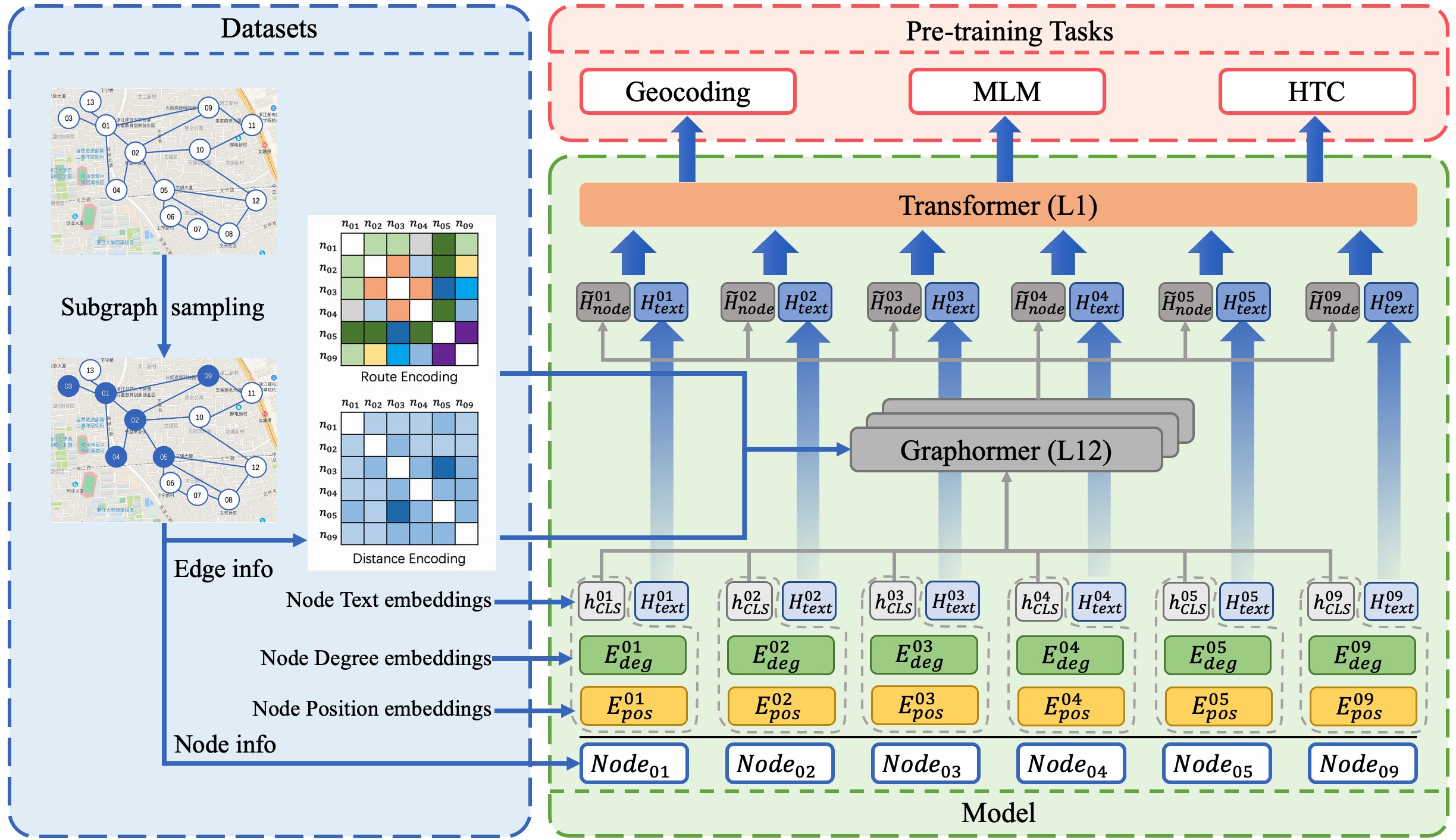
We use Cainiao’s delivery data to construct a large-scale heterogeneous graph, which contains delivery addresses and their spatial location relationship. The heterogeneous graph takes delivery addresses as nodes and the relationship between addresses as edges. We design three different types of edges to represent the relationship types between addresses. The graph structure of the dataset is shown in Figure 1. Detailed statistics are shown in Table 1. Next, we describe the elements of the heterogeneous graph in detail.
3.1.1. Node
The delivery address in the logistics system is usually composed of province, city, district, town, and detailed address. In daily application, users usually add some address information (road, POI name, house number, etc.) and other remark information (put it at the door, put it in the courier cabinet, put it in the post station, etc.) to the detailed address. The detailed address descriptions of different users bring new challenges to its data processing:
-
(1)
Redundant description. The delivery address is usually detailed to the house number, which leads to hundreds or even thousands of different address descriptions for a POI. And with different address remarks, there are billions of different delivery addresses in China.
-
(2)
Alias. For the same POI, different users will use different POI names, such as “CCTV Headquarters”, which some users call it as “Big Pants” because of its pants-building shape. In China, most apartment communities have aliases.
Therefore, we design a paradigm to normalize the delivery address. We use the address entity tokenization tool to segment the address according to the administrative regions and reorganize it according to the paradigm: [POI administrative address + POI name]. POI administrative addresses are composed of “province + city + district + town + road + road number” in sequence. We also use this paradigm as the address representation of nodes in the heterogeneous graph. Limited by the performance of the address entity tokenization tool, the same POI may have multiple POI administrative addresses. We select the top four administrative addresses for a POI according to the number of user descriptions, which can greatly reduce the expansion of addresses number caused by house numbers and remark information. In the purpose of solving the alias problem, we first use the detailed address to make a judgment. POIs alias relationship is identified when administrative addresses are exactly matched. Second, we enrich the aliases of POI names using the POI library. For POIs with aliases, we also swapped their administrative addresses to enrich the address in the heterogeneous graph.
3.1.2. Edge
There are three types of edges in the heterogeneous graph of the dataset.
-
(1)
Delivery Route. It is used to represent the courier’s delivery route in the real logistics system, and this edge is obtained by analyzing the courier’s daily delivery records.
-
(2)
AOI Co-locate. For the logistics system, packages are usually delivered according to the AOI area, and different POIs within the same AOI should have a high degree of spatial correlation. Therefore, we connect different POIs within the same AOI through edges.
-
(3)
Alias. We expect G2PTL to learn the alias relationship of different addresses, so if a node and another node are in the alias relationship, we will build an Alias edge between the two nodes.
There may be multiple types of edges between different nodes, so we encode the edges between nodes according to their types. We use the binary encoding to get the type code of an edge: the Delivery Route edge is at position 0, the AOI Co-locate edge is at position 1 and the Alias edge is at position 2. For example, there are Delivery Route edges and Alias edges between node A and node B, the edge between node A and node B is coded as “101”.
3.2. Training sample
The training sample of G2PTL is a subgraph sampled from the heterogeneous graph. We use to represent a training sample, where represents the node connection information in the heterogeneous graph. , where and represent two nodes connected by edge . When sampling the data, we first set a base node , and then sample a node from its first-order neighbor node set . During the sampling process, the base node has a probability to be transferred to other nodes until the number of nodes in the sample reaches the set value. Finally, we obtain the mutual adjacency relationship between all nodes in from the heterogeneous graph to form the final training samples. Each training sample is finally represented as an independent subgraph, as shown in Figure 1.
3.3. Model architecture
The G2PTL model is mainly composed of three parts: i) a Transformer encoder for extracting the text representation of the address, which calculates the embedding vector of the input address; ii) a Graphormer encoder for learning graph structure, which incorporates graph information by modifying the self-attention matrix based on the multi-head self-attention module; iii) a Transformer encoder for aggregate and redistribute the information of each node in the graph. The Graphormer encoder consists of a composition of Graphormer Layers. The model architecture is shown in Figure 2.
The representation of node in G2PTL contains three parts: sentence text feature , node degree feature and node position feature .
| (1) |
We first insert a “[CLS]” token into the head of the node address, and then use the sentence-piece algorithm to tokenize the text into a sub-word sequence , where denotes the first sub-word token of text without “[CLS]” and is the length of the sub-word sequence. We use the Transformer encoder to get the text vector representation of node :
| (2) |
where is the final hidden vector of the token “[CLS]”, which is the aggregated representation of , and is the hidden vector of .
The value of the degree of a node usually indicates the importance and influence of the node in the graph. The training sample is an undirected graph, and the outdegree of the node is the same as the indegree, so we only count the indegree of the node. We use an embedding layer to encode the degree of the node to obtain its vector representation . Similarly, we can obtain the vector representation of the node’s position, because the position of the node in the graph is also important. As shown in Algorithm 1, the nodes in the sample are added sequentially. We mark the order of adding nodes as the position of the node in the training sample, which is represented by a number (1, 2, 3…n). We use an embedding layer to encode the position number of the node to obtain the position embedding.
The input of edge information in G2PTL depends on the node distance matrix and the node path type matrix. For a training sample with nodes, the node distance matrix records the shortest distance value between nodes, with dimension . The node path type matrix records the path information corresponding to the shortest distance between nodes, which is composed of the type code of each edge in the path, with dimension . We use an embedding layer to encode the node distance matrix to obtain the Distance Encoding representation of the training sample; for the processing of the node path type matrix, we first use an embedding layer to encode it, and then average the embedding value in the node dimension to obtain the Route Encoding representation of the training sample. We add and as biases to the self-attention matrix of the Graphormer encoder and use the self-attention result as the final output.
To learn the spatial relationship between nodes, we first aggregate the representations of nodes and then use Graphormer encoder to redistribute it to each node. Specifically, we concatenate the representations of all nodes into a matrix , with dimension .
The first Graphormer Layer in Graphormer encoder uses as the node feature input and outputs a new node feature hidden vector , is also the input of the next Graphormer Layer. During the stack calculation of the Graphormer Layer, we fix and . The calculation process of the Graphormer Layer is as follows:
| (3) |
| (4) |
| (5) |
| (6) |
The input is projected by three matrices ,, to the corresponding representations , , . FC() contains 2 independent fully connected layers.
After computation of Graphormer encoder, is denoted as , denotes the new representation with graph information of node . We recombine and of each node to form a new hidden vector representation of the node and use it as the input of :
| (7) |
where and are used as input for pre-training tasks.
In G2PTL, the initial representation of each node consists of 2 parts: and . Graphormer encoder takes the of each node in the sample as node’s features, and obtains the output of each node by aggregating and passing the features of all nodes. This will cause the information inside the to be misaligned with the information in the for each node, because the already contains spatial topological relationship between different nodes and the aggregated knowledge of all nodes. So we designed a Transformer encoder to align the information in and for each node. At the same time, we use to transform the hidden vector dimension, making it suitable for a series of different downstream tasks.
3.4. Pre-training tasks
3.4.1. Masked Language Modeling
In logistics systems, the addresses provided by users are often incomplete, partially duplicated, or misspelled. We hope that when the address part is partially missing or incorrect, the model can still accurately identify the semantic information in the address. We use the MLM task to learn the semantic information in the address, and the input noise brought by the MLM task can enhance the model’s ability to correct address errors when the address entered by the user is wrong. During the model training phase, the node’s address for training contains the POI name and POI administrative address, where the POI administrative address is composed of multiple administrative regions. We found that it is unreasonable to mask an administrative region name with a single word. For example, the masked input of “Hang [MASK] City, Zhejiang Province” is too simple for the model, because among all the cities in Zhejiang Province, only Hangzhou City contains the word “Hang”. Therefore, we change the mask mechanism of the POI administrative address to the whole word mask (WWM), that is, once an administrative region is selected, all the words of the region name will be masked. In that case, masked input becomes “[MASK], Zhejiang Province”. During the training process, each region has a 15% probability of being selected, and for the selected region, we replace each word in the region name with “[MASK]” token with 80% probability, replace the region name with another region name of the same administrative level with 10% probability, and leave the region name unchanged with 10% probability. For the POI name, we use the same setting for mask probability, the difference is that the unit of the mask is each word in the POI name. This pre-training task enables the model to learn the relationship between POI names and the natural semantic information of address.
3.4.2. Geocoding
In order to learn the relationship between address and geographic coordinates, we use the S2 geometry discrete global grid (DGG) system to map the coordinates of the address to its corresponding S2 cell (level 18), which covers an area around 1,200. S2 system uses spherical projections, which significantly reduces the distortion caused by Mercator projection. At the same time, S2 is a hierarchical system in which each cell (we call this cell as S2 cell) is a “box reference” to a subset of cells. By using the S2 cell, the geocoding task is transformed into a classification task, and each S2 cell obtains the classification label using the 2Lt3C encoding method (Huang et al., 2022). Every 2-level S2 cell will be encoded into 3 characters by 2Lt3C, and we designed 27 independent classifiers to predict each character.
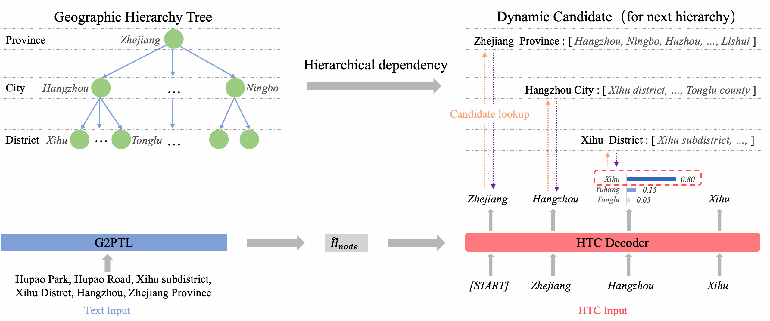
3.4.3. Hierarchical Text Classification
Delivery addresses are usually arranged from high-level administrative regions to low-level ones. In order to solve the problem of hierarchical structure of the address, we use the HTC task to learn the administrative hierarchical relations between different administrative regions. Recall that the goal of this task is to find a node path, which is from coarse-grained at the upper level to fine-grained at the lower level according to the level of the administrative region. We first construct a tree with a depth of 5 according to the hierarchical information of the administrative region, and each node of the tree represents an administrative region. According to the parent node and child nodes of the nodes in the tree, we can know the upper-level region information and lower-level region information of each administrative region. The model uses sequential forecasting to get the level of each administrative region in the delivery address. For each delivery address, we first forecast the administrative region whose level is 1 and then find out all its subordinate region sets in the tree, and the prediction results of the next level are constrained within this set until the last level.
4. EXPERIMENTS
In this section, we present the experimental results of G2PTL in different logistics-related tasks and demonstrate the superiority of G2PTL in logistics-related tasks by comparing it with other general NLP-based PTMs and geospatial representation PTMs. At the same time, we explore the importance of each module in G2PTL through ablation experiments.
4.1. Logistics-related Tasks
4.1.1. Geocoding
The geocoding task aims to convert the address into latitude-longitude coordinates of the corresponding location on earth. We use Cainiao’s manually labeled data to evaluate the geocoding task and sample 80,000 addresses as the training set, 10,000 addresses as the validation set, and 10,000 addresses as the test set. For each address, we first use the 2Lt3C method to obtain its corresponding S2 cell (level 22) code representation. Then we use PTM to extract the hidden vector (see Equation 2) of the address as the input of the geocoding task, and use a fully connected layer for classification and fine-tuning. We use “Accuracy@N Km” as the metric, which measures the percentage of predicted locations that are apart with a distance of less than N Km to their actual physical locations. In our experiments, we set N to 1. We first decode the model output to get the center point of the S2 cell, then calculate the distance between the center point and the real label, and finally use this distance to calculate the metric.
4.1.2. Pick-up Estimation Time of Arrival
The Pick-up Estimation Time of Arrival (PETA) task aims to predict the arrival time of all packages not picked up by the courier in real-time, which is a multi-destination prediction problem without routing information. The improvement of PETA’s accuracy rate can help the logistics system to better dispatch orders, measure the courier’s overdue risk, and reduce customers’ waiting anxiety. We use Acc@N Min and Mean Absolute Error (MAE) as metrics for the PETA task. For a single package that has not been picked up, we calculate the minute difference k between the actual arrival time of the package and the model’s estimated result. If k¡N, the model’s prediction for the package is correct. We use FDNET (Gao et al., 2021) as the backbone model to evaluate the PETA task, and we use of the PTM for the package address as input. We collected the delivery information of 170,000 real logistics packages and used them to generate 31,000 training samples, 10,000 validation samples, and 5,000 test samples. In our experiments, we set N to 20.
4.1.3. Address Entity Prediction
The Address Entity Prediction (AEP) task aims to predict the missing administrative region information in delivery address. Many delivery addresses filled by users in the logistics system lack administrative region, and these incomplete addresses bring great challenges to address parsing service. In Cainiao, there are many orders that fail to be delivered every day, because the incomplete address cannot be parsed correctly. We collected the address data of 50,000 orders in Cainiao, and randomly masked the administrative region. The model needs to predict the masked part of the address. For the general PTMs, we first use PTM to extract the hidden vector (see Equation 2) of each word in the address, then use the fully connected layer for nonlinear transformation, and finally output the prediction results of N independent classifiers, where N is the length of the masked part. For G2PTL, we use the results of the HTC task as prediction results. We use accuracy as the metric for the AEP task.
4.1.4. Address Entity Tokenization
The Address entity tokenization (AET) task is similar to the named entity recognition (NER) task of natural language processing (NLP), which tokenizes the address into different geographic entities according to the administrative information of the entity. The accuracy of AET directly affects the performance of address parsing. We collected the address data of 50,000 orders and used Cainiao’s address tokenization online service to obtain the name and administrative information of each geographic entity in the address, and each word belonging to the same geographic entity was set with the same classification label. Limited by the accuracy of online services, we manually labeled 5,000 addresses as the validation set and 5,000 addresses as the test set. The AET task mainly recognizes the contextual information of the word dimension in the address, and the model needs to classify each word in the address. We first use PTM to extract the hidden vector (see Equation 2) of each word in the address, then use the fully connected layer to perform the nonlinear transformation, and finally output the classification results of each word by N independent classifiers, where N is the length of the address. We use accuracy as the metric of the AET task, which is calculated in units of geographic entities.
At the same time, we use the public dataset GeoGLUE 111https://modelscope.cn/datasets/damo/GeoGLUE/summary to test different PTMs. Limited by the data format of GeoGLUE, we test AEP and AET tasks.
| Task | #Train | #Val | #Test | Metric |
| Geocoding | 80,000 | 10,000 | 10,000 | Acc@N km |
| PETA | 31,000 | 10,000 | 5,000 | Acc@N Min and MAE |
| AEP | 40,000 | 5,000 | 5,000 | Accuracy |
| AET | 40,000 | 5,000 | 5,000 | Accuracy |
| Pre-trained model | Geocoding | Pick-up Estimation Time of Arrival | Address Entity Prediction | Address Entity Tokenization | Average | |
| Acc@1 km | Acc@20 Min | MAE | Accuracy | Accuracy | ||
| BERT | 54.45% | 17.88% | 69.84 | 49.56% | 84.13% | 0.5151 |
| MacBERT | 52.15% | 16.64% | 70.60 | 50.26% | 84.15% | 0.5080 |
| ERNIE 3.0 | 42.15% | 17.80% | 70.13 | 50.54% | 83.61% | 0.4853 |
| GeoBERT | 50.30% | 18.16% | 69.84 | 52.42% | 89.89% | 0.5269 |
| ERNIE-GeoL | 55.20% | 18.37% | 69.80 | 53.70% | 89.67% | 0.5424 |
| MGeo | 60.40% | 18.30% | 70.37 | 53.28% | 90.98% | 0.5574 |
| G2PTL | 65.95% | 18.71% | 69.38 | 91.94% | 93.61% | 0.6755 |
| — w/o Graphormer Layer | 57.65% | 18.19% | 70.55 | 69.75% | 92.13% | 0.5943 |
| — w/o Geocoding Task | 54.95% | 18.30% | 70.31 | 89.14% | 91.44% | 0.6346 |
| — w/o HTC Task | 55.45% | 17.68% | 70.84 | 58.58% | 90.96% | 0.5567 |
| Pre-trained model | Address Entity Prediction | Address Entity Tokenization |
| Accuracy | Accuracy | |
| BERT | 49.97% | 92.47% |
| MacBERT | 48.63% | 91.93% |
| ERNIE 3.0 | 50.77% | 91.70% |
| GeoBERT | 52.23% | 94.02% |
| ERNIE-GeoL | 55.35% | 93.96% |
| MGeo | 56.93% | 94.57% |
| G2PTL | 74.07% | 98.17% |
| -w/o Graphormer Layer | 60.43% | 97.25% |
| -w/o Geocoding Task | 68.87% | 96.48% |
| -w/o HTC Task | 57.33% | 94.12% |
4.2. Experimental Setup
4.2.1. Datasets
In our experiments, we construct the heterogeneous graph using logistics delivery records within a 6-month from Cainiao. The heterogeneous graph contains 37.7 million address nodes, 108 million Delivery Route edges, 4.4 billion AOI Co-locate edges, and 3.1 million Alias edges. We sample 200 million samples from the heterogeneous graph using Algorithm 1, the number of nodes in each sample is set to 6, and the transition probability is set to 0.8.
4.2.2. Pre-trained models
We first evaluate the performance of three widely used general PTMs in logistics related tasks, including BERT (Kenton and Toutanova, 2019), MacBERT (Cui et al., 2020) and ERNIE 3.0 (Sun et al., 2021). Considering the lack of geographical knowledge in the training corpora of general PTMs, we further test the performance of the geospatial representation PTMs in logistics related tasks, including GeoBERT (Gao et al., 2022), MGeo (Ding et al., 2023) and ERNIE-GeoL (Huang et al., 2022). Since the data and code of ERNIE-GeoL are not released, we only adopt the pre-training objectives. We also perform ablation experiments on multiple parts of G2PTL to determine their relative importance:
-
•
G2PTL w/o Graphormer Layer: In this setting, we remove the Graphormer Layer of G2PTL (see Section 3.3).
-
•
G2PTL w/o Geocoding Task: In this setting, we remove the geocoding pre-training task (see Section 3.4.2).
-
•
G2PTL w/o HTC Task: In this setting, we remove the HTC pre-training task (see Section 3.4.3).
The hyperparameters of and in G2PTL are the same as those of other PTMs compared in the Table 3, the hidden layer size is 768, and the number of attention heads is 12. The number of hidden layers in is 12, and the number of hidden layers in is 1. The Graphormer encoder of G2PTL contains 12 Graphormer Layers, of which the size of the hidden layer is 768, and the number of attention heads is 8. We train G2PTL for about a week on 10 Nvidia A100 GPUs. When fine-tuning on downstream tasks, we use the Adam optimizer (Kingma and Ba, 2014) with the learning rate initialized to and gradually decreased during the process of training until the training loss converges.
4.3. Results and Analysis
We first evaluate the performance of G2PTL and other PTMs on logistics-related tasks. The results in Table 3 show that G2PTL significantly outperforms other PTMs on logistics-related tasks, and achieving the highest scores on each downstream task and the highest average score of 0.6755. The results in Table 4 show that the address parsing performance of G2PTL is also better than other models on GeoGLUE. Experimental results show that G2PTL has comprehensively learned general geographic knowledge and logistics field knowledge, and this knowledge can significantly improve the performance of logistics-related tasks.
In the ablation experiments, we figure out the importance of each module in G2PTL. From the average score, the Geocoding task and the HTC task have the greatest impact on logistics-related tasks. Because G2PTL is a domain-specific PTM, its domain knowledge is mainly obtained through training corpora and pre-training tasks. Next, we explore the importance of each module of G2PTL in different downstream tasks. (1) For the geocoding task, we found that the “Acc@1 km” of “G2PTL w/o Geocoding Task” has an absolute drop of 11% compared to G2PTL, which is also the largest drop in all ablation experiments. An important reason for this decrease is that geocoding is also a pre-training task because the “Acc@1 km” of “G2PTL w/o Geocoding Task” is close to that of BERT. This also proves the importance of geocoding pre-training task. Compared with G2PTL, “G2PTL w/o Graphormer Layer” gets an absolute drop of 8.3%. This indicates that the introduction of the Graphormer to learn aggregation information between adjacent addresses can obtain better latitude and longitude mapping results. (2) For short-term metrics such as “Acc@20 Min” in the PETA task, the most important module is the HTC task, because these short-term metrics only focus on the address information of the current package, and do not care about long-term spatio-temporal information. (3) For AEP and AET tasks, the most important module is also the HTC task, and the least important is the graph. On the one hand, the geographic administrative knowledge of the model is obtained through the HTC pre-training task, and on the other hand, AEP and AET tasks use the hidden vector of each sub-word in the input address, it focuses on the relationship of sub-words in the address, and does not focus on the spatial relationship between different addresses.

4.4. The Geographical Knowledge of G2PTL
4.4.1. Geographical knowledge of relative locations
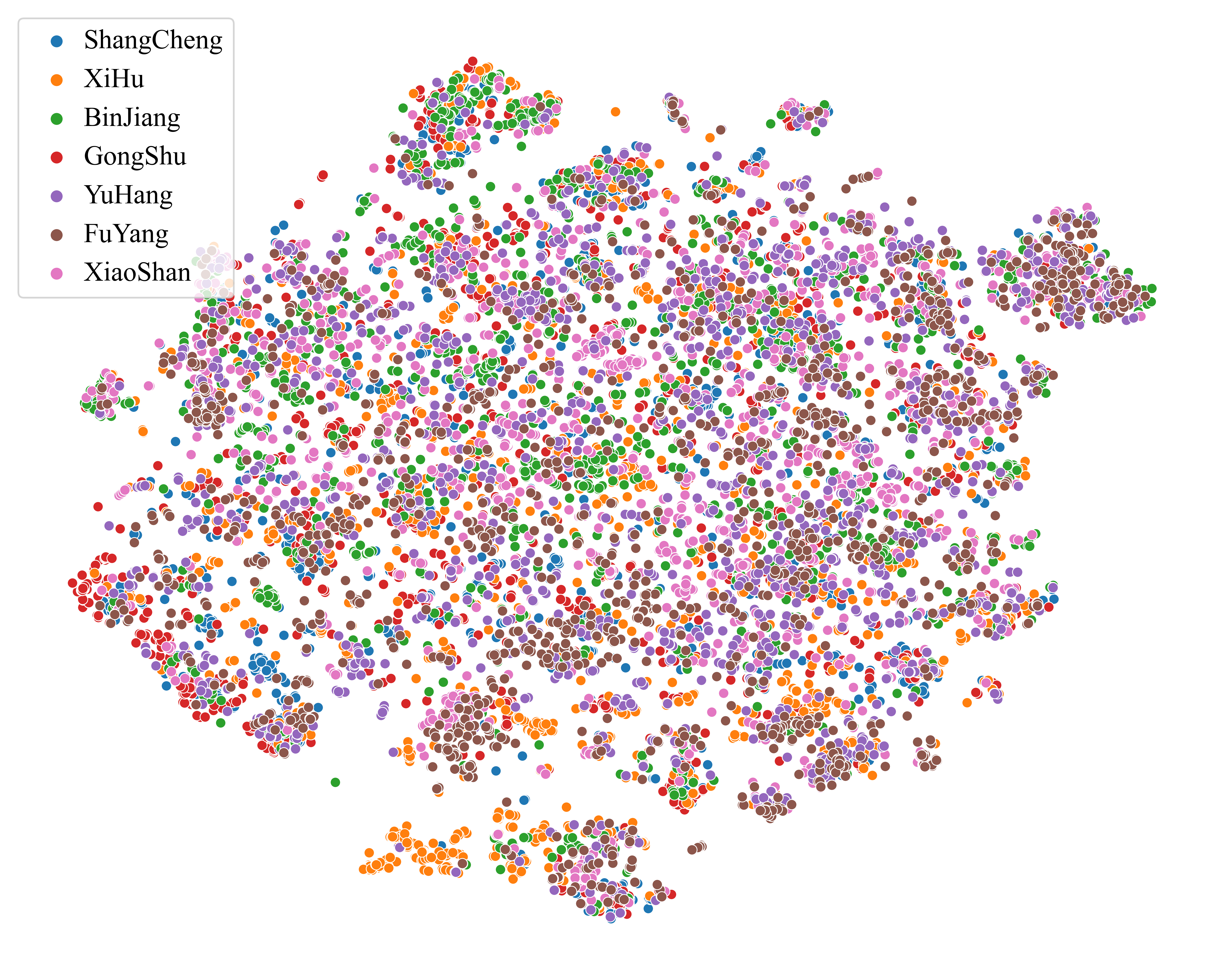
To study the geographical knowledge of relative locations learned by G2PTL, we first use PTM to extract the hidden vector representation of the “[CLS]” token in the address, and then use the t-distributed stochastic neighbor embedding (t-SNE) method to project it into a two-dimensional space. We select seven districts in Hangzhou City, each district has 2,000 addresses. The t-SNE visualization results of BERT and G2PTL are shown in Figure 4. From this, we can see that the t-SNE embeddings predicted by G2PTL (Figure 4b) are more discriminative than those predicted by BERT (Figure 4a), with higher aggregation in the same regions. This shows that G2PTL can distinguish addresses located in different regions, and can learn geographical proximity information of different regions. For example, the XiHu district and the GongShu district are adjacent in Figure 4b, which is the same as in the real world. At the same time, we use Silhouette Score and Calinski-Harabaz (CH) Index to evaluate the sample aggregation degree of t-SNE visualization results, and the results are shown in Table 5. Compared with other general PTMs, G2PTL obtained significantly better aggregation evaluation results, and the CH Index reached 4,854.81, which shows that G2PTL has an excellent ability to identify address areas. The results of the ablation experiments in Table 5 prove that both the model structure and the pre-training tasks make significant contributions to G2PTL’s geographical knowledge learning.
| Pre-trained model | Silhouette Score | CH Index |
| BERT | -0.072 | 77.17 |
| MacBERT | -0.042 | 29.33 |
| ERNIE 3.0 | -0.064 | 67.53 |
| GeoBERT | 0.009 | 2227.06 |
| ERNIE-GeoL | -0.054 | 802.24 |
| MGeo | 0.173 | 3772.61 |
| G2PTL | 0.264 | 4,854.81 |
| -w/o Graphormer Layer | -0.006 | 890.07 |
| -w/o Geocoding Task | -0.049 | 652.76 |
| -w/o HTC Task | -0.025 | 431.85 |
4.4.2. Geographical knowledge of administrative regions
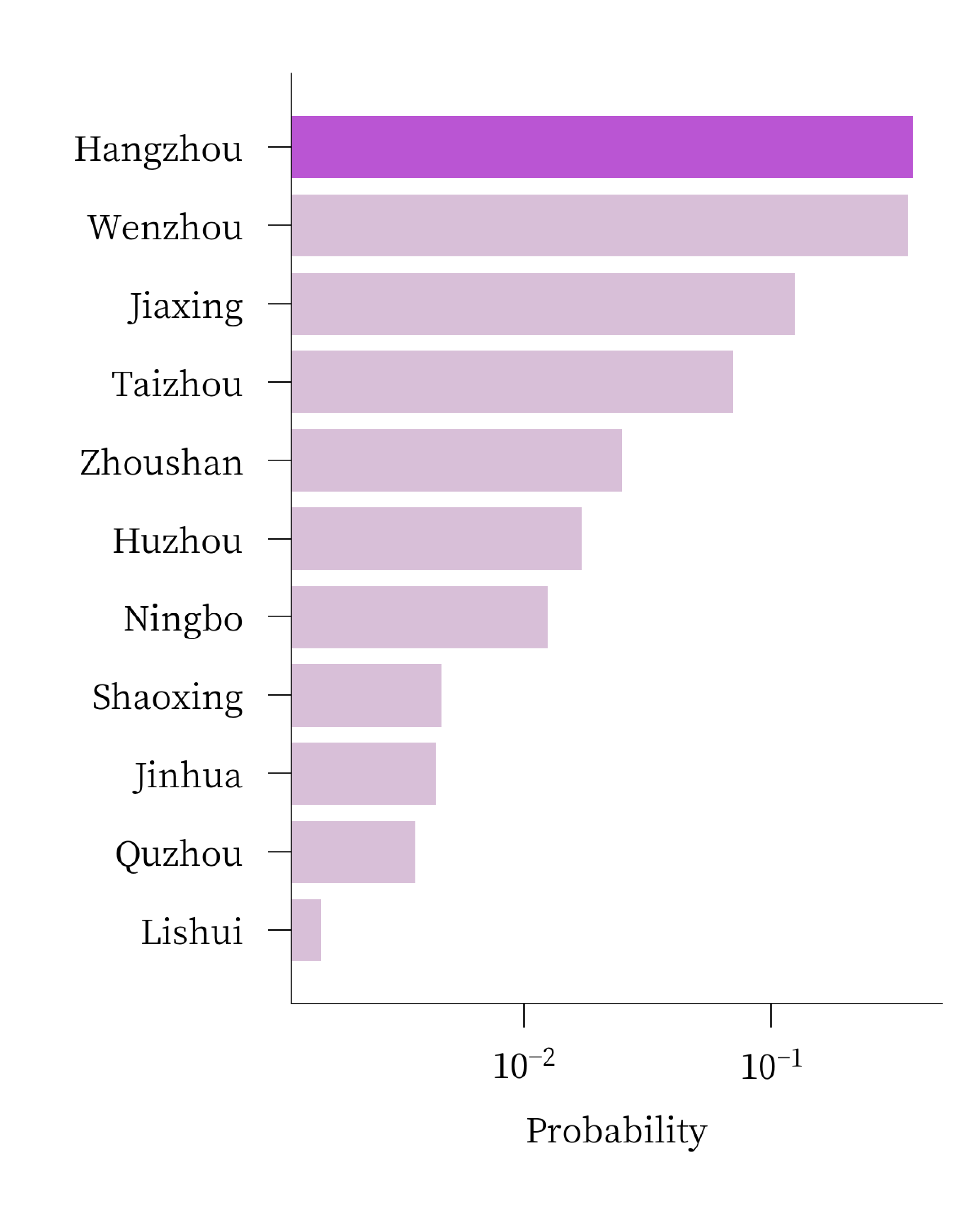
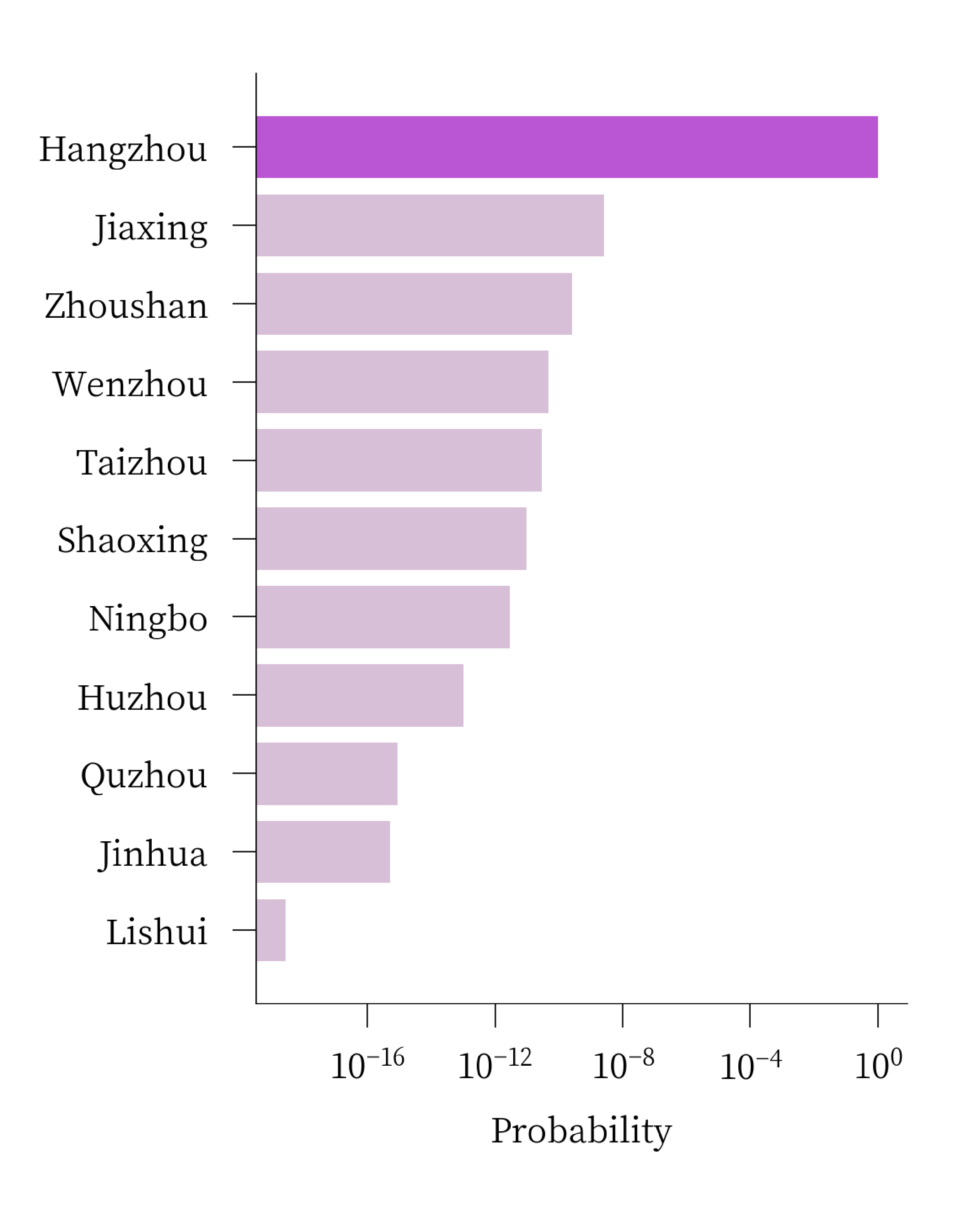
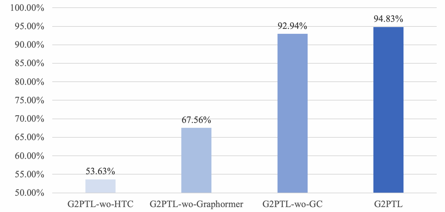
We randomly replace single or multiple geographic entities in address with “[mask]” tokens and then predict them by using PTM. The prediction results can only be selected from geographic entities of the same administrative level, which belong to the upper-level geographic region. We curate two test cases to check the prediction results of PTMs, as shown in Figure 5 and Figure 6. We show the prediction probabilities of the PTM for different geographic entities, and the labels are highlighted in the figure. For Case 1, the prediction results of BERT and G2PTL are correct, but the prediction results of BERT are not as discriminative as the results of G2PTL. For Case 2, the prediction result of BERT is wrong, and the prediction probability of G2PTL for the label is still far ahead. This shows that G2PTL has learned the administrative region information of geographic entities and the relationship between different administrative regions. We randomly masked the geographic entities in 10,000 addresses, and then use them to calculate the prediction accuracy of G2PTL. The experimental results are shown in Figure 7. The prediction accuracy of G2PTL for geographic entities reaches 94.83%. The HTC task brings a 41.2% improvement in absolute accuracy, which shows that the acquisition of administrative knowledge in G2PTL mainly relies on the HTC task.
5. CONCLUSIONS AND FUTURE WORK
In this paper, we proposed G2PTL, a pre-trained domain-specific model for delivery addresses in the field of logistics. G2PTL overcomes the shortcomings of other PTMs and boosts the performance of delivery-related tasks.
With the specifically designed data set, model architecture and pre-training tasks, G2PTL achieves excellent results in delivery-related tasks compared to other PTMs. The training sample of G2PTL is a subgraph sampled from a heterogeneous graph constructed based on Cainiao’s package pick-up and delivery data. G2PTL uses multiple encoder structures to learn the address representation with graph information, and utilizes three pre-training tasks to learn geographic knowledge and the spatial relationship information of delivery addresses. G2PTL is evaluated on four downstream tasks, which provide fundamental support to the logistics system. Experimental results and ablation studies demonstrate that G2PTL outperforms other general NLP-based PTMs and geospatial representation PTMs. The improvement brought by the deployment of G2PTL to Cainiao’s logistics system proves that it can serve as a promising foundation for delivery-related tasks.
In future work, we plan to introduce more information to further improve the geographical representation ability of G2PTL, including but not limited to the following: 1) image data (package receipt images, satellite images, address aerial photos, etc.); 2) logistics knowledge (the difficulty of delivery, area accessibility, etc.); 3) marketing knowledge (purchasing power, surrounding malls, etc.). Another interesting direction is extending our pre-trained model to serve other location-based services, such as food delivery.
References
- (1)
- Adams and McKenzie (2018) Benjamin Adams and Grant McKenzie. 2018. Crowdsourcing the character of a place: Character-level convolutional networks for multilingual geographic text classification. Transactions in GIS 22, 2 (2018), 394–408. https://doi.org/10.1111/tgis.12317 arXiv:https://onlinelibrary.wiley.com/doi/pdf/10.1111/tgis.12317
- Alsentzer et al. (2019) Emily Alsentzer, John R Murphy, Willie Boag, Wei-Hung Weng, Di Jin, Tristan Naumann, and Matthew McDermott. 2019. Publicly available clinical BERT embeddings. arXiv preprint arXiv:1904.03323 (2019).
- Araci (2019) D. Araci. 2019. FinBERT: Financial Sentiment Analysis with Pre-trained Language Models.
- Beltagy et al. (2019) Iz Beltagy, Kyle Lo, and Arman Cohan. 2019. SciBERT: A pretrained language model for scientific text. arXiv preprint arXiv:1903.10676 (2019).
- Cardoso et al. (2022) Ana Bárbara Cardoso, Bruno Martins, and Jacinto Estima. 2022. A Novel Deep Learning Approach Using Contextual Embeddings for Toponym Resolution. ISPRS International Journal of Geo-Information 11, 1 (2022). https://doi.org/10.3390/ijgi11010028
- Cui et al. (2020) Yiming Cui, Wanxiang Che, Ting Liu, Bing Qin, Shijin Wang, and Guoping Hu. 2020. Revisiting pre-trained models for Chinese natural language processing. arXiv preprint arXiv:2004.13922 (2020).
- Ding et al. (2023) Ruixue Ding, Boli Chen, Pengjun Xie, Fei Huang, Xin Li, Qiang Zhang, and Yao Xu. 2023. A Multi-Modal Geographic Pre-Training Method. CoRR abs/2301.04283 (2023). https://doi.org/10.48550/arXiv.2301.04283 arXiv:2301.04283
- Feng et al. (2017) Shanshan Feng, Gao Cong, Bo An, and Yeow Meng Chee. 2017. POI2Vec: Geographical Latent Representation for Predicting Future Visitors. Proceedings of the AAAI Conference on Artificial Intelligence 31, 1 (Feb. 2017). https://doi.org/10.1609/aaai.v31i1.10500
- Floridi and Chiriatti (2020) Luciano Floridi and Massimo Chiriatti. 2020. GPT-3: Its nature, scope, limits, and consequences. Minds and Machines 30, 4 (2020), 681–694.
- Gao et al. (2021) Chengliang Gao, Fan Zhang, Guanqun Wu, Qiwan Hu, Qiang Ru, Jinghua Hao, Renqing He, and Zhizhao Sun. 2021. A Deep Learning Method for Route and Time Prediction in Food Delivery Service. In Proceedings of the 27th ACM SIGKDD Conference on Knowledge Discovery & Data Mining. 2879–2889.
- Gao et al. (2022) Yunfan Gao, Yun Xiong, Siqi Wang, and Haofen Wang. 2022. GeoBERT: Pre-Training Geospatial Representation Learning on Point-of-Interest. Applied Sciences 12, 24 (2022). https://doi.org/10.3390/app122412942
- Goldberg et al. (2007) Daniel W. Goldberg, John P. Wilson, and Craig A. Knoblock. 2007. From Text to Geographic Coordinates: The Current State of Geocoding. URISA Journal 19 (2007).
- Gu et al. (2021) Yu Gu, Robert Tinn, Hao Cheng, Michael Lucas, Naoto Usuyama, Xiaodong Liu, Tristan Naumann, Jianfeng Gao, and Hoifung Poon. 2021. Domain-specific language model pretraining for biomedical natural language processing. ACM Transactions on Computing for Healthcare (HEALTH) 3, 1 (2021), 1–23.
- Huang et al. (2021) Jizhou Huang, Haifeng Wang, Yibo Sun, Miao Fan, Zhengjie Huang, Chunyuan Yuan, and Yawen Li. 2021. HGAMN: Heterogeneous Graph Attention Matching Network for Multilingual POI Retrieval at Baidu Maps. In Proceedings of the 27th ACM SIGKDD Conference on Knowledge Discovery & Data Mining. 3032–3040.
- Huang et al. (2022) Jizhou Huang, Haifeng Wang, Yibo Sun, Yunsheng Shi, Zhengjie Huang, An Zhuo, and Shikun Feng. 2022. ERNIE-GeoL: A Geography-and-Language Pre-trained Model and its Applications in Baidu Maps. In Proceedings of the 28th ACM SIGKDD Conference on Knowledge Discovery and Data Mining. 3029–3039.
- Kenton and Toutanova (2019) Jacob Devlin Ming-Wei Chang Kenton and Lee Kristina Toutanova. 2019. Bert: Pre-training of deep bidirectional transformers for language understanding. In Proceedings of naacL-HLT. 4171–4186.
- Kingma and Ba (2014) Diederik P Kingma and Jimmy Ba. 2014. Adam: A method for stochastic optimization. arXiv preprint arXiv:1412.6980 (2014).
- Lan et al. (2020) Yu-Lin Lan, Fagui Liu, Wing WY Ng, Jun Zhang, and Mengke Gui. 2020. Decomposition based multi-objective variable neighborhood descent algorithm for logistics dispatching. IEEE Transactions on Emerging Topics in Computational Intelligence 5, 5 (2020), 826–839.
- Lee et al. (2020) Jinhyuk Lee, Wonjin Yoon, Sungdong Kim, Donghyeon Kim, Sunkyu Kim, Chan Ho So, and Jaewoo Kang. 2020. BioBERT: a pre-trained biomedical language representation model for biomedical text mining. Bioinformatics 36, 4 (2020), 1234–1240.
- Lee and Hsiang (2019) Jieh-Sheng Lee and Jieh Hsiang. 2019. Patentbert: Patent classification with fine-tuning a pre-trained bert model. arXiv preprint arXiv:1906.02124 (2019).
- Li et al. (2019a) Hao Li, Wei Lu, Pengjun Xie, and Linlin Li. 2019a. Neural Chinese Address Parsing. In Proceedings of the 2019 Conference of the North American Chapter of the Association for Computational Linguistics: Human Language Technologies, Volume 1 (Long and Short Papers). Association for Computational Linguistics, Minneapolis, Minnesota, 3421–3431. https://doi.org/10.18653/v1/N19-1346
- Li et al. (2019b) Liunian Harold Li, Mark Yatskar, Da Yin, Cho-Jui Hsieh, and Kai-Wei Chang. 2019b. Visualbert: A simple and performant baseline for vision and language. arXiv preprint arXiv:1908.03557 (2019).
- Liu et al. (2020) Weijie Liu, Peng Zhou, Zhe Zhao, Zhiruo Wang, Qi Ju, Haotang Deng, and Ping Wang. 2020. K-bert: Enabling language representation with knowledge graph. In Proceedings of the AAAI Conference on Artificial Intelligence, Vol. 34. 2901–2908.
- Lu et al. (2019) Jiasen Lu, Dhruv Batra, Devi Parikh, and Stefan Lee. 2019. Vilbert: Pretraining task-agnostic visiolinguistic representations for vision-and-language tasks. Advances in neural information processing systems 32 (2019).
- Mai et al. (2022) Gengchen Mai, Krzysztof Janowicz, Yingjie Hu, Song Gao, Bo Yan, Rui Zhu, Ling Cai, and Ni Lao. 2022. A review of location encoding for GeoAI: methods and applications. International Journal of Geographical Information Science 36, 4 (2022), 639–673. https://doi.org/10.1080/13658816.2021.2004602 arXiv:https://doi.org/10.1080/13658816.2021.2004602
- Mikolov et al. (2013) Tomas Mikolov, Ilya Sutskever, Kai Chen, Greg S Corrado, and Jeff Dean. 2013. Distributed Representations of Words and Phrases and their Compositionality. In Advances in Neural Information Processing Systems, C.J. Burges, L. Bottou, M. Welling, Z. Ghahramani, and K.Q. Weinberger (Eds.), Vol. 26. Curran Associates, Inc. https://proceedings.neurips.cc/paper_files/paper/2013/file/9aa42b31882ec039965f3c4923ce901b-Paper.pdf
- Peng et al. (2019) Yifan Peng, Shankai Yan, and Zhiyong Lu. 2019. Transfer learning in biomedical natural language processing: an evaluation of BERT and ELMo on ten benchmarking datasets. arXiv preprint arXiv:1906.05474 (2019).
- Peters et al. (2018) Matthew E. Peters, Mark Neumann, Mohit Iyyer, Matt Gardner, Christopher Clark, Kenton Lee, and Luke Zettlemoyer. 2018. Deep Contextualized Word Representations. In Proceedings of the 2018 Conference of the North American Chapter of the Association for Computational Linguistics: Human Language Technologies, Volume 1 (Long Papers). Association for Computational Linguistics, New Orleans, Louisiana, 2227–2237. https://doi.org/10.18653/v1/N18-1202
- raj Kanakarajan et al. (2021) Kamal raj Kanakarajan, Bhuvana Kundumani, and Malaikannan Sankarasubbu. 2021. BioELECTRA: pretrained biomedical text encoder using discriminators. (2021), 143–154.
- Speriosu and Baldridge (2013) Michael Speriosu and Jason Baldridge. 2013. Text-Driven Toponym Resolution using Indirect Supervision. In Annual Meeting of the Association for Computational Linguistics.
- Sun et al. (2020) Tianxiang Sun, Yunfan Shao, Xipeng Qiu, Qipeng Guo, Yaru Hu, Xuanjing Huang, and Zheng Zhang. 2020. Colake: Contextualized language and knowledge embedding. arXiv preprint arXiv:2010.00309 (2020).
- Sun et al. (2021) Y. Sun, S. Wang, S. Feng, S. Ding, and H. Wang. 2021. ERNIE 3.0: Large-scale Knowledge Enhanced Pre-training for Language Understanding and Generation. arXiv preprint arXiv:2107.02137 (2021).
- Vaswani et al. (2017) Ashish Vaswani, Noam Shazeer, Niki Parmar, Jakob Uszkoreit, Llion Jones, Aidan N Gomez, Ł ukasz Kaiser, and Illia Polosukhin. 2017. Attention is All you Need. In Advances in Neural Information Processing Systems, I. Guyon, U. Von Luxburg, S. Bengio, H. Wallach, R. Fergus, S. Vishwanathan, and R. Garnett (Eds.), Vol. 30. Curran Associates, Inc. https://proceedings.neurips.cc/paper/2017/file/3f5ee243547dee91fbd053c1c4a845aa-Paper.pdf
- Velickovic et al. (2017) Petar Velickovic, Guillem Cucurull, Arantxa Casanova, Adriana Romero, Pietro Lio, and Yoshua Bengio. 2017. Graph attention networks. stat 1050 (2017), 20.
- Wen et al. (2021) Haomin Wen, Youfang Lin, Fan Wu, Huaiyu Wan, and Yinghui Xu. 2021. Package Pick-up Route Prediction via Modeling Couriers’ Spatial-Temporal Behaviors. In 2021 IEEE 37th International Conference on Data Engineering (ICDE).
- Wing and Baldridge (2011) Benjamin P. Wing and Jason Baldridge. 2011. Simple Supervised Document Geolocation with Geodesic Grids. In Proceedings of the 49th Annual Meeting of the Association for Computational Linguistics: Human Language Technologies - Volume 1 (Portland, Oregon) (HLT ’11). Association for Computational Linguistics, USA, 955–964.
- Xiang (2020) Mingjun Xiang. 2020. Region2vec: An Approach for Urban Land Use Detection by Fusing Multiple Features. In Proceedings of the 2020 6th International Conference on Computing and Artificial Intelligence (Tianjin, China) (ICCAI ’20). Association for Computing Machinery, New York, NY, USA, 13–18. https://doi.org/10.1145/3404555.3404613
- Yao et al. (2017) Yao Yao, Xia Li, Xiaoping Liu, Penghua Liu, Zhaotang Liang, Jinbao Zhang, and Ke Mai. 2017. Sensing spatial distribution of urban land use by integrating points-of-interest and Google Word2Vec model. International Journal of Geographical Information Science 31, 4 (2017), 825–848. https://doi.org/10.1080/13658816.2016.1244608 arXiv:https://doi.org/10.1080/13658816.2016.1244608
- Ying et al. (2021) Chengxuan Ying, Tianle Cai, Shengjie Luo, Shuxin Zheng, Guolin Ke, Di He, Yanming Shen, and Tie-Yan Liu. 2021. Do transformers really perform badly for graph representation? Advances in Neural Information Processing Systems 34 (2021), 28877–28888.
- Yu et al. (2022) Chao Yu, Yi Shen, and Yue Mao. 2022. Constrained Sequence-to-Tree Generation for Hierarchical Text Classification. In Proceedings of the 45th International ACM SIGIR Conference on Research and Development in Information Retrieval. 1865–1869.
- Yu et al. (2021) Fei Yu, Jiji Tang, Weichong Yin, Yu Sun, Hao Tian, Hua Wu, and Haifeng Wang. 2021. Ernie-vil: Knowledge enhanced vision-language representations through scene graphs. In Proceedings of the AAAI Conference on Artificial Intelligence, Vol. 35. 3208–3216.
- Zhou et al. (2020) Jie Zhou, Chunping Ma, Dingkun Long, Guangwei Xu, Ning Ding, Haoyu Zhang, Pengjun Xie, and Gongshen Liu. 2020. Hierarchy-Aware Global Model for Hierarchical Text Classification. In Proceedings of the 58th Annual Meeting of the Association for Computational Linguistics. Association for Computational Linguistics, Online, 1106–1117. https://doi.org/10.18653/v1/2020.acl-main.104
- Zhu et al. (2019) Minfeng Zhu, Wei Chen, Jiazhi Xia, Yuxin Ma, Yankong Zhang, Yuetong Luo, Zhaosong Huang, and Liangjun Liu. 2019. Location2vec: A Situation-Aware Representation for Visual Exploration of Urban Locations. IEEE Transactions on Intelligent Transportation Systems 20, 10 (2019), 3981–3990. https://doi.org/10.1109/TITS.2019.2901117