Embedded light-weight approach for safe landing in populated areas
Abstract
Landing safety is a challenge heavily engaging the research community recently, due to the increasing interest in applications availed by aerial vehicles. In this paper, we propose a landing safety pipeline based on state of the art object detectors and OctoMap. First, a point cloud of surface obstacles is generated, which is then inserted in an OctoMap. The unoccupied areas are identified, thus resulting to a list of safe landing points. Due to the low inference time achieved by state of the art object detectors and the efficient point cloud manipulation using OctoMap, it is feasible for our approach to deploy on low-weight embedded systems. The proposed pipeline has been evaluated in many simulation scenarios, varying in people density, number, and movement. Simulations were executed with an Nvidia Jetson Nano in the loop to confirm the pipeline’s performance and robustness in a low computing power hardware. The experiments yielded promising results with a 95% success rate.
Index Terms:
Safe Landing, Object Detectors, OctoMap, Point Cloud, PX4, UAVI Introduction
Contemporary research in robotics evince that modern unmanned aerial vehicles (UAVs) are able to cope with a variety of diverging and demanding applications, such as terrain mapping, surveillance, search and rescue, photogrammetry, etc. [1] Notwithstanding the increasing autonomy and intelligence endowed to UAVs, factors leading to their failure are still present [2]. Therefore, precaution is of paramount importance, especially in the case a UAV overflying residential areas. During an event of a light system failure, such as loss of data-link, battery malfunction, etc., the most common fail-safe scenario is emergency landing. In such a situation, the ultimate goal would be to avoid injuring people in crowded regions [3]. Depending on the type of the aerial platform, e.g. fixed wing, multi-rotor, etc., and the flight scenario, e.g. indoor/outdoor, remote/populated area, safe landing might appear to be a complex problem, particularly in cases where a predefined fail-safe landing spot is proscribed [4]. Safe landing in crowded areas is a strenuous task due to the volatility of the environment, owed to multiple diverging parameters, such as moving people, variable terrain, camera moves, occlusions etc. Systems allowing safe touch down ideally need to operate in real-time and run locally on the UAV’s on-board computer, on account of the fact that data-link loss constitutes a fairly usual failure . Real-time performance is another trammel, as UAVs face more stringent limitations compared to other autonomous systems, owed to their physical limitations on weight, size, and battery capacity [6]. Recent advancements in deep learning methods led to algorithms efficient enough for real-time operation on low-end hardware [7], [8][9],[10].
Motivated by the aforementioned barriers, in this paper we attempt to present a solution for safe UAV landing in human inhabited areas. The proposed method is meant to fit in embedded onboard hardware with the aim to facilitate the autonomy of the flying vehicle. The rest of the paper is organized as follows. Section II discusses the related work. Section III presents the proposed method. Section IV exhibits the experiments conducted to test the proposed pipeline, as well as the data produced. In Section V a useful discussion of our findings is provided, while in SectionVI conclusions are drawn and our plans for future work are presented.
II Related work
The proposed work focuses on the extraction of safe landing zones (SLZ) through the detection of landing obstacles, in our case people. In general SLZ extraction algorithms are classified into two categories. The ones that segment flat regions, which can be used to land safely, avoiding landing obstacles, such as vegetation, people, equipment, etc. The solution proposed by the authors in [11] is based on the concept that safe regions in images tend to have flat surfaces. Therefore, with the aim to extract those regions, Gabor filters have been employed. As a result, images with different orientations can be obtained and in each of them, the candidate pixels are grouped using Markov chain codes. The system detects the candidate region with the biggest area and then it estimates the degree of similarity between the reference region and the corresponding ones. In [12] the authors present a complete modular framework for landing site selection, which comprises a point cloud prepossessing module, a coarse landing site selection module, a fine terrain evaluation module and a landing optimal model. The pipeline was designed to achieve real-time performance. It was also tested in different real world known and unknown scenarios. A similar approach for fixed wing aircrafts was proposed in [13], where landing hazards are considered as terrain roughness and slope. The UAV’s on-board extended Kalman filter considers the surrounding obstacles that occlude landing and calculates a landing approach path. A method based on a deep learning approach was presented in [4]. The proposed model was built on a semantic segmentation architecture. The thematic classes of the terrain are mapped into safety-scores for UAV landing.
Most of the contemporary landing obstacle detection algorithms –including crowd detection ones– avail themselves of the efficiency and performance deep neural networks exhibit. The identification of obstacles at ground level is usually accomplished by estimating crowd densities. While useful, in the case of UAVs the constant change of perspective renders the image plane density with no immediate physical meaning. The authors in [14] model the scale changes and reason in terms of people per square-meter. Feeding this model to a network allows for scale consistency. In [15], the authors present a two-loss model where classification is supported by regression. This is performed by resorting to the construction of a spatial graph for each analyzed image and the evaluation of each cluster. The semantic information is derived by a class activation heat-map. Another crowd detection algorithm based on deep neural networks is presented in [16]. The authors’ main contribution was the proposal of a lightweight architecture, in which a deep learning graph regularization technique is attached to all neural layers of their proposed CNN model. Another very interesting crowd detection method is proposed in [17] where the crowd density map is generated in each image and projected in the head plane. A binary occupancy map is generated and the SLZs are obtained as circular regions with a minimum security radius.
In the proposed approach, we put forward a modular framework111The pipeline along with the evaluation module can be found at GitHub: https://github.com/telemc97/safety_pipeline.git aiming to create an occupancy grid for a UAV to avoid people. The whole pipeline was designed to be as lightweight as possible so as to achieve real-time performance on lower-end hardware and thus be deployable on UAVs. The first module incorporates an object detector producing a point cloud, each point of which represents a detection. The second module aims to increase the performance of the system by inserting the point cloud into an OctoMap. By projecting each OctoMap node onto the ground plane we manage to create an occupancy grid containing only the landing-obstacles. Having outlined the operability of the proposed approach, we now can summarize its main contribution as follows:
-
•
A lightweight system based on ROS [18] which can be implemented in lower-end hardware and capitalises on the advancements of the object detectors to find landing obstacles with great accuracy and low inference time.
-
•
The representation of the landing obstacles, i.e. people, as OctoMap nodes, which boosts performance. Additionally, it copes with the uncertainty and inaccuracy of spatial measurements in a probabilistic manner. Finally, inserting the point cloud into an OctoMap not only frees up resources but additionally, it enables the map to be updated by different sensors adding a a semantic dimension to it.
-
•
An SLZ detection algorithm that produces a redundant amount of landing point candidates. Hence, in case a spot is characterized occupied (due to changing environment), the closest unoccupied spot is available at any time.
III Methodology
In this work, we propose a complete lightweight system that builds an occupancy map of the terrain, chooses the safest landing point available and controls the overall landing procedure. The method relies upon two primary “pillars”, namely state of the art object detectors and OctoMaps. Most of the recently reported works focus on DNN architectures, serving to achieve a safe landing on flat surfaces in the presence of moving obstacles, such as people. Our approach to the problem uses a state of the art object detector, namely the YOLO V7, exploiting its real time performance to execute consecutive detections. The framework comprises of three modules, the Point Cloud Generator (PCG), the Temporal OctoMap (TOM) generator and the Landing Commander (LC). Our architecture is illustrated in Fig. 1. In the rest of the Section, we shall extensively present each module comprising the proposed framework.
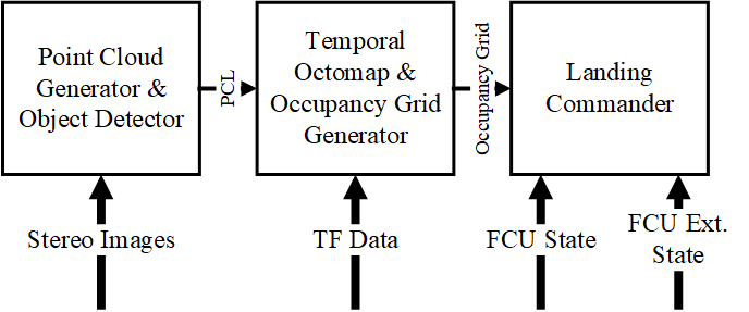
III-A Point Cloud Generator
Real-time object detection has concerned many computer vision scholars in their attempt to solve different practical problems [19]. A state of the art tool is the YOLO family of models. In particular, YOLOv7 is an object detector that surpasses all known object detectors in both speed and accuracy [19]. Due to various optimizations the above model achieves high performance gains that strengthen the training for improving the accuracy without impacting the inference speed. The low inference latency is a key element to our pipeline, since it benefits from the consequent detections. The first pipeline module applies YOLO v7 to a synchronised image pair acquired through a stereo camera mounted on the UAV. The YOLO v7 architecture has been trained with the Okutama-Action Dataset [20] for people detection from the overhead view. The detections in both images are matched with k-nearest neighbor [21] resulting in the position of the landing obstacle relatively to the camera frame. Finally, a Robotic Operating System (ROS) “pointcloud2” message is populated with those observations. Note that, point cloud management is not very efficient and pose performance issues to embedded GPUs.
III-B Temporal OctoMap
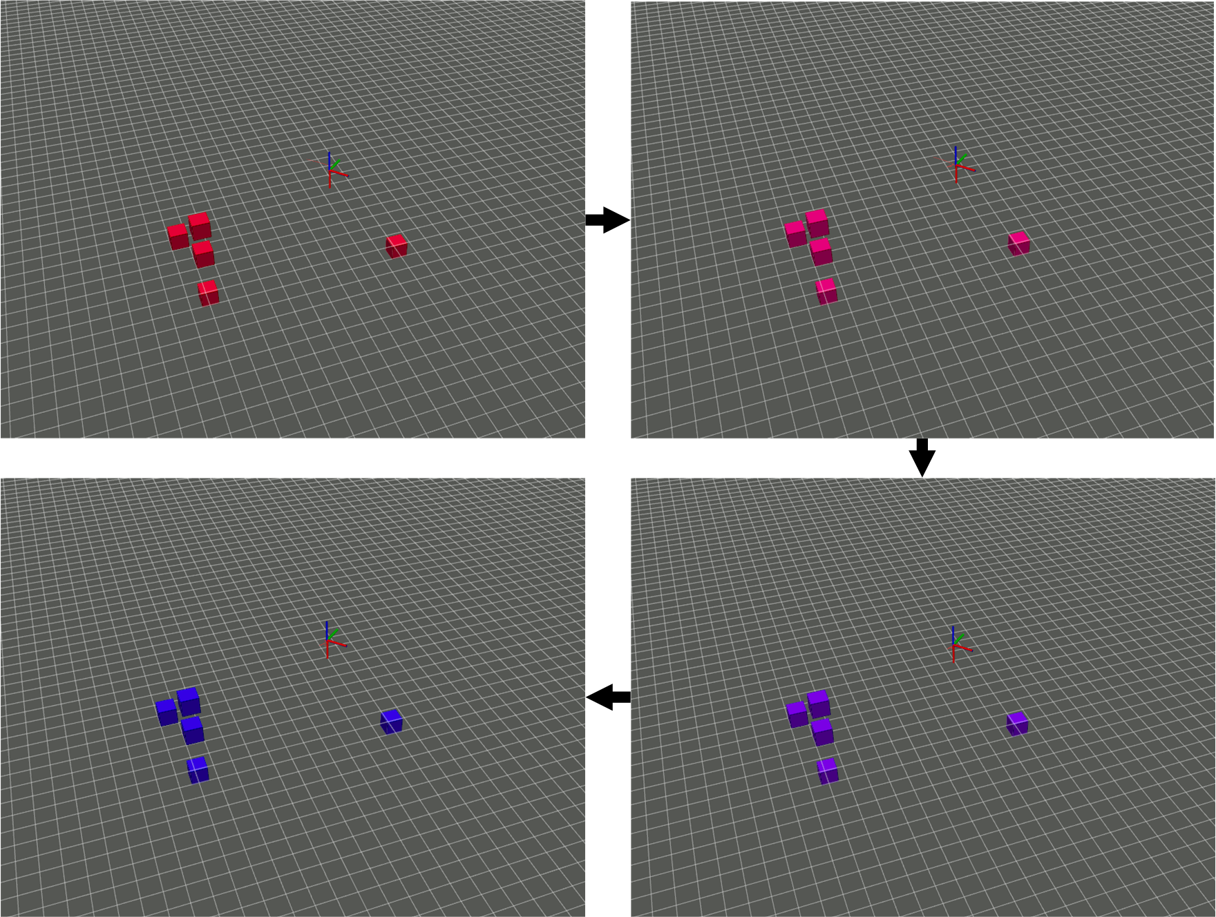
An OctoMap is a 3D mapping representation of the environment, which provides an efficient probabilistic 3D mapping framework [22]. The primary purpose of the second pipeline module is to update the occupancy probabilities of the voxels in the octree by means of the point cloud data generated from the previous module. Occupied voxels are projected onto the ground plane to form an occupancy grid, which comprises the output of this module. OctoMap handles measurements in a probabilistic manner to cope with errors generated from inertial and optical sensors. Due to the fact that mobile robots operate in a dynamic environment moving obstacles should be taken into consideration. Each Octree node is stamped and deleted on a specific timeline in case it is not re-initialized. To visualize that feature, each node is assigned with a color dependent on its remaining lifetime. Red signifies newly initialized nodes, while blue ones are close to their lifetime end as seen in Fig. 2. Another issue of embedded systems is their lack of processing power, thus, algorithms ought to be as efficient as possible in respect to memory access time and consumption.
III-C Landing Commander
The occupancy grid () deriving from the previous module is fed into the last one. The reason being to extract safe-landing zones and initiate landing along with supervising it. Owning to the fact that every occupied cell represents a landing obstacle a convolution function, can be applied on the occupancy grid:
| (1) |
| (2) |
Therefore, a new occupancy grid with safety margins for each occupied cell is derived (). For each cell with value another convolutional function is applied:
| (3) |
| (4) |
In the case that the coordinates are free, thus safe for landing. Hence, the euclidean distance between the UAV and the point is calculated. For efficiency purposes, the inspection of the occupancy grid is required to be dynamic. The processing time () is dependent on parameters of the occupancy grid, such as its size (), the ratio between occupied and unoccupied cells (), the stride () and the kernel size (). It is approximately calculated by the Eq. 5:
| (5) |
Solving for stride () and multiplying with an intensity coefficient () we result in:
| (6) |
By incorporating Eq. 6 in our algorithm, we can approximately keep the processing time of the function at a steady rate, regardless the size of the occupancy grid (Fig. 4).
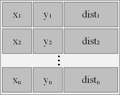
Each valid point along with its distance is stored in a list sorted in ascending row (Fig. 3). The element at position represents the safe landing point closer to the UAV. An arbitrary point can be chosen as the landing target and therefore the algorithm will calculate the Euclidean distance between this point and each valid safe landing coordinates. In the event that a new moving obstacle is observed, the state of the selected landing target changes to occupied. Therefore, the element will change to the closest unoccupied coordinate.
IV Experimental results
IV-A Experimental Setup
This section presents the experiments performed to evaluate the proposed solution. As mentioned in Section III the pipeline consists of three modules, each of which necessitates to be assessed independently. The whole system also needs to be evaluated as well. The processing time of each module is logged along with the training metrics of the network used in the PCG.
Our pipeline has been extensively tested in the Gazebo environment. The UAV autopilot of our choice is PX4 [23] due to ROS compatibility. The ease in take-off and landing that the quadrotor layout exhibits, renders it the most suitable for our application [24]. The model used in the Gazebo simulation was the one presented in [25, 26].
Three different environment types were created: The first is sparsely populated with static people, the second is densely populated equally with static people while the third environment includes people that dynamically move in a specific area. Their behaviour is based on the Social Force Model for Social Local Navigation [27, 28].
| Setup | CPU | GPU | RAM |
| Setup #1 | Intel i7-9750H | RTX 2060 | 16Gb |
| Setup #2 | Quad-core ARM Cortex-A57 | NVIDIA Maxwell architecture (128 CUDA cores) | 4Gb |
In total, 25 experiments were conducted. More specifically, experiments # 0-4 were performed in the first environment, along with YOLO v5 as the object detector for the PCG. Experiments # 5-9 were performed in the second environment with YOLO v5 as well. Experiments # 10-14 were completed again in environment, yet YOLO v7 was used in this batch. Experiments # 15-24 were performed in the third environment. In both cases, the object detector in use was the YOLO v7, while the last 5 were executed with an Nvidia Jetson Nano (Setup #2 Table I) in the loop shouldering the safety pipeline while Setup #1 is responsible for the simulation. In that way we are able to confirm that the system can be deployed effectively in feeble hardware.
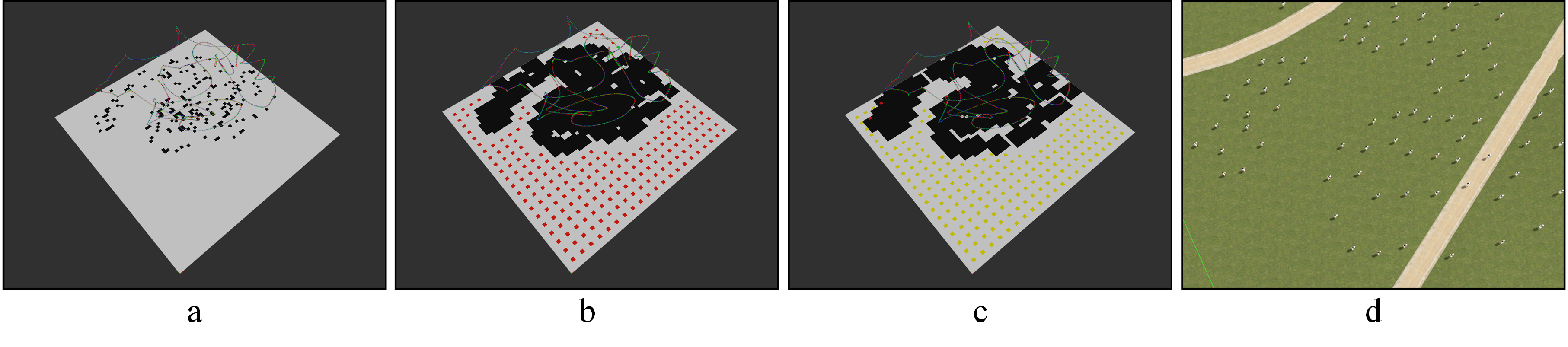
An independent module was created to evaluate the performance and accuracy of the entire system. This is achieved by reconstructing a ground truth occupancy map from the simulated Gazebo world () and comparing it with the occupancy grid produced by the third module of our pipeline (). As a result their IoU is derived:
| (7) |
The landing spots sum along with those rightfully characterized unoccupied are similarly logged as performance metrics. Lastly, upon a successful landing, the Euclidean distance to the nearest landing obstacle is also logged as proposed in [6].
IV-B DNN Training
As mentioned in the previous section, YOLO consists a “pillar” of our pipeline. We used YOLO v5 (yolov5s), YOLO v7 (yolov7) and YOLO v7 tiny. Despite the fact that the pipeline was firstly be implemented using YOLO v5 (yolov5s), it was updated to state of the art YOLO v7 and YOLO v7 tiny. According to [19], YOLO v7 offers 36.89% increase in Average Precision () and 3% increase in frames per second (fps) compared to YOLO v5 (yolov5s), yet it consists of 412.5% more parameters. YOLO v7 tiny compared to yolov5s offers 83.33% increase in fps while maintaining approximately the same AP (3.7% increase in AP).
IV-C Dataset
All of the networks were trained in the Okutama-Action Dataset. It includes top-down images of people captured by UAVs flying at multiple altitudes and angles. Okutama-Action also, features action annotations for each person, which is beyond the scope of our purpose. With YOLO v5 and YOLO v7, pre-trained on the COCO Dataset [29], after 10 epochs, we achieved a precision of 84% and 86%, respectively. In the case of YOLO v7 tiny, with no transfer learning after 30 epochs, we reached a maximum accuracy of 77.8%.
| Model | Precision | mAP0.5 | mAP0.5:0.95 | Epochs |
| YOLOv5S | 0.84091 | 0.8135 | 0.30011 | 10 |
| YOLOv7 | 0.8617 | 0.3142 | 0.06646 | 10 |
| YOLOv7tiny | 0.7778 | 0.752 | 0.2543 | 30 |
IV-D Processing times
One of the primary objectives of this pipeline was to achieve real-time performance across every module. While the processing time of the first two modules is hardware depended, LC rate of execution depends on scenario-specific parameters, such as mission area, landing obstacles, etc. As seen in Fig. 7 and Fig. 6, the dynamic stride manages to keep the inference time of the LC module stable at an average of in the case of Setup #1 and in the case of the Setup #2 (Nvidia Jetson Nano). Based on the adjustments in the stride coefficient ( in Eq. 6), we can increase the number of possible landing points by sacrificing the performance.
We conclude that the only module with a significant deviation in performance is the PCG which is GPU dependent, owning to the object detector. Using a model developed for edge GPU-oriented architecture such as YOLO v7 tiny is enough to enhance the performance.
IV-E Overall Metrics
The entire pipeline is evaluated according to its IoU and the sum of possible unoccupied landing coordinates. Specifically, our algorithm produces a total quantity of land points, where the percentage of valid unoccupied landing points based on ground truth occupancy represents the system’s accuracy. Since the IoU depends on the exact consecutive observations of the area, the accuracy of the pipeline depends on the duration and flight path. As the UAV proceeds with its mission the IoU is increasing (Fig. 4). The Euclidean distance between the UAV and the nearest landing obstacle is also calculated upon landing. The algorithm excludes areas in a certain radius for each detected landing obstacle. In our tests, the radius was set to 2m hence, in case that the shortest distance is less than 2m, the test was determined as failed. Ultimately from the 25 experiments a success rate of 93,33% was achieved. In experiment #5, upon landing, the minimum distance between the UAV and the landing obstacle was 1m (Table III) 222We have recorded each experiment in the Rosbag format. They can be found on the following GitHub repository: https://github.com/telemc97/safety_pipeline_experiments.git. This complication can be blamed either on the resolution of the occupancy grid (1m), which can be altered or on the drift during the landing procedure. Increasing the safety radius at the expense of the number of available landing points can resolve the above fault as well.
| Test #. | Success | Min Dist. | IoU | Valid Points |
| 0 | True | 17m | 0.59 | 99.65% |
| 1 | True | 10m | 0.47 | 96.46% |
| 5 | False | 1m | 0.54 | 88.96% |
| 6 | True | 19m | 0.28 | 78.96% |
| 9 | True | 11m | 0.62 | 97.5% |
| 10 | True | 2m | 0.71 | 96.61% |
| 14 | True | 2m | 0.75 | 98.96% |
| 17 | True | 15m | 0.5 | 98.79% |
| 18 | True | 2m | 0.54 | 100% |
| 21 | True | 2m | 0.46 | 99% |
| 22 | True | 2m | 0.42 | 100% |
V Discussion
The objective of the proposed pipeline is to be modular, lightweight, and easily deployable on different platforms. To achieve modularity we decomposed the problem into three sub-modules each with discrete input and output as seen in Fig. 1. Needless to say that the modularity in the proposed design allowed for the development to move from older YOLO version e.g YOLO v5 and YOLOR to YOLO v7. The low inference times were achieved by keeping only the information required for tackling the problem, in that case, avoiding landing obstacles in emergency landing scenarios. Aiding with efficiency the spatial information is stored as an OctoMap. The ease of deployment in a variety of platforms was achieved by developing the whole pipeline using ROS [30]. As seen from the experiment results, the performance both in regard to accuracy and latency is heavily dependent on the object detector used. In both setups (I) using YOLO v7, Setup #1 achieved an average latency of while Setup #2 (Fig. 6 and Fig. 7). This can be combated by using a more lightweight model as discussed in subsection IV-B in cost of accuracy. While the pipeline in the context of this paper is limited in detecting and avoiding only people during landing, this can be easily altered by training the network of the PCG module to detect a different set of landing obstacles. The pipeline can also be extended to integrate a slope detection module [31], so that uneven terrains would be excluded as well. Another way that the framework can be extended is to give each landing spot a score based on a multi-criteria analysis in relation to slope, people density and activity, distance from base or UAV, detection confidence etc. Ultimately, by augmenting the OctoMap derived by our pipeline with other sensors e.g. Lidars it can acquire a semantic dimension by having the landing obstacles pinpointed [32, 33].
VI Conclusion
To conclude we propose a landing safety pipeline which is based on state of the art object detectors and OctoMap. It consists of three modules: The first one creates a point cloud which comprises the object detector’s detection in world coordinates, the second module converts this point cloud to OctoMap to generate an occupancy grid projecting the occupied voxels on the ground plane, and the last module takes on the detection of landing points and oversees the landing procedure upon reaching them. Achieving real time performance is of utmost priority for our solution while, the ease of deployment in a variety of platforms will facilitate its further development. The pipeline can be improved by introducing a decision tree procedure in the landing module to determine the best landing point according to certain conditions (e.g. remaining battery, RSSI signal strength, etc.). Thus, in our future work, we plan to extend the proposed framework by incorporating a decision tree algorithm for efficient area searching in case of initialization of a landing point candidate as occupied. Multiple parameters must be taken into consideration. Such parameters may include the terrain slope, searching radius based on distance from the base and remaining battery life, landing obstacle density of the terrain, etc. Moreover, the system can be modified to incorporate structure from motion, replacing the stereo camera setup in the PCG. Last, we intend to upgrade our methodology by applying the state of the art YOLO v8, which is have been publicly released only recently.
Acknowledgement
This research has been co-financed by the European Regional Development Fund of the European Union and Greek national funds through the Operational Program Competitiveness, Entrepreneurship, and Innovation, under the call RESEARCH – CREATE – INNOVATE (project code: T2EDK-00592).
References
- [1] B. Alzahrani, O. S. Oubbati, A. Barnawi, M. Atiquzzaman, and D. Alghazzawi, “Uav assistance paradigm: State-of-the-art in applications and challenges,” Journal of Network and Computer Applications, vol. 166, p. 102706, 2020.
- [2] S. Charalampidou, E. Lygouras, I. Dokas, A. Gasteratos, and A. Zacharopoulou, “A sociotechnical approach to uav safety for search and rescue missions,” in 2020 International Conference on Unmanned Aircraft Systems (ICUAS). IEEE, 2020, pp. 1416–1424.
- [3] J. A. Gonzalez-Trejo and D. A. Mercado-Ravell, “Lightweight density map architecture for uavs safe landing in crowded areas,” J. of Intell. & Robot. Syst., vol. 102, no. 1, pp. 1–15, 2021.
- [4] S. Abdollahzadeh, P.-L. Proulx, M. S. Allili, and J.-F. Lapointe, “Safe landing zones detection for uavs using deep regression,” 2022, pp. 213–218.
- [5] M. Shah Alam and J. Oluoch, “A survey of safe landing zone detection techniques for autonomous unmanned aerial vehicles (uavs),” Expert Syst. with Appl., vol. 179, p. 115091, 2021.
- [6] C. Symeonidis, E. Kakaletsis, I. Mademlis, N. Nikolaidis, A. Tefas, and I. Pitas, “Vision-based uav safe landing exploiting lightweight deep neural networks,” 2021, pp. 13––19.
- [7] E. Lygouras, A. Gasteratos, K. Tarchanidis, and A. Mitropoulos, “Rolfer: A fully autonomous aerial rescue support system,” Microprocessors and Microsystems, vol. 61, pp. 32–42, 2018.
- [8] E. Lygouras, N. Santavas, A. Taitzoglou, K. Tarchanidis, A. Mitropoulos, and A. Gasteratos, “Unsupervised human detection with an embedded vision system on a fully autonomous uav for search and rescue operations,” Sensors, vol. 19, no. 16, p. 3542, 2019.
- [9] J.-W. Lee, W. Lee, and K.-D. Kim, “An algorithm for local dynamic map generation for safe uav navigation,” Drones, vol. 5, no. 3, 2021.
- [10] E. Kakaletsis, C. Symeonidis, M. Tzelepi, I. Mademlis, A. Tefas, N. Nikolaidis, and I. Pitas, “Computer vision for autonomous uav flight safety: An overview and a vision-based safe landing pipeline example,” no. 9, 2021.
- [11] M. A. Kaljahi, P. Shivakumara, M. Y. I. Idris, M. H. Anisi, T. Lu, M. Blumenstein, and N. M. Noor, “An automatic zone detection system for safe landing of uavs,” Expert Syst. with Appl., vol. 122, pp. 319–333, 2019.
- [12] L. Yang, C. Wang, and L. Wang, “Autonomous uavs landing site selection from point cloud in unknown environments,” ISA Trans., vol. 130, pp. 610–628, 2022.
- [13] T. Hinzmann, T. Stastny, C. Cadena, R. Siegwart, and I. Gilitschenski, “Free lsd: Prior-free visual landing site detection for autonomous planes,” IEEE Robot. and Automat. Letters, vol. 3, no. 3, pp. 2545–2552, 2018.
- [14] W. Liu, K. Lis, M. Salzmann, and P. Fua, “Geometric and physical constraints for drone-based head plane crowd density estimation,” in 2019 IEEE/RSJ International Conference on Intelligent Robots and Systems (IROS), 2019, pp. 244–249.
- [15] G. Castellano, C. Castiello, C. Mencar, and G. Vessio, “Crowd detection in aerial images using spatial graphs and fully-convolutional neural networks,” IEEE Access, vol. 8, pp. 64 534–64 544, 2020.
- [16] M. Tzelepi and A. Tefas, “Graph embedded convolutional neural networks in human crowd detection for drone flight safety,” IEEE Trans. on Emerg. Topics in Comput. Intell., vol. 5, no. 2, pp. 191–204, 2021.
- [17] J. González-Trejo, D. Mercado-Ravell, I. Becerra, and R. Murrieta-Cid, “On the visual-based safe landing of uavs in populated areas: A crucial aspect for urban deployment,” IEEE Robot. and Automat. Letters, vol. 6, no. 4, pp. 7901–7908, 2021.
- [18] R. Mehrotra, K. Namuduri, and N. Ranganathan, “Gabor filter-based edge detection,” Pattern Recognition, vol. 25, no. 12, pp. 1479–1494, 1992.
- [19] C.-Y. Wang, A. Bochkovskiy, and H.-Y. M. Liao, “Yolov7: Trainable bag-of-freebies sets new state-of-the-art for real-time object detectors,” 2022.
- [20] M. Barekatain, M. Marti, H.-F. Shih, S. Murray, K. Nakayama, Y. Matsuo, and H. Prendinger, “Okutama-action: An aerial view video dataset for concurrent human action detection,” in Proceedings of the IEEE Conference on Computer Vision and Pattern Recognition (CVPR) Workshops, July 2017.
- [21] S. Leutenegger, M. Chli, and R. Y. Siegwart, “Brisk: Binary robust invariant scalable keypoints,” in 2011 International Conference on Computer Vision, 2011, pp. 2548–2555.
- [22] A. Hornung, K. M. Wurm, M. Bennewitz, C. Stachniss, and W. Burgard, “Octomap: An efficient probabilistic 3d mapping framework based on octrees,” Auton Robots, vol. 34, no. 3, pp. 189–206, 2013.
- [23] L. Meier, D. Honegger, and M. Pollefeys, “Px4: A node-based multithreaded open source robotics framework for deeply embedded platforms,” in 2015 IEEE Internatio Conference on Robotics and Automation (ICRA), 2015, pp. 6235–6240.
- [24] W. Kwon, J. H. Park, M. Lee, J. Her, S.-H. Kim, and J.-W. Seo, “Robust autonomous navigation of unmanned aerial vehicles (uavs) for warehouses’ inventory application,” IEEE Robot. and Automat. Letters, vol. 5, no. 1, pp. 243–249, 2020.
- [25] T. Mitroudas, K. A. Tsintotas, N. Santavas, A. Psomoulis, and A. Gasteratos, “Towards 3d printed modular unmanned aerial vehicle development: The landing safety paradigm,” 2022, pp. 1–6.
- [26] K. A. Tsintotas, L. Bampis, A. Taitzoglou, I. Kansizoglou, P. Kaparos, C. Bliamis, K. Yakinthos, and A. Gasteratos, “The mpu rx-4 project: Design, electronics, and software development of a geofence protection system for a fixed-wing vtol uav,” IEEE Transactions on Instrumentation and Measurement, vol. 72, pp. 1–13, 2023.
- [27] M. Moussaïd, D. Helbing, S. Garnier, A. Johansson, M. Combe, and G. Theraulaz, “Experimental study of the behavioural mechanisms underlying self-organization in human crowds,” Proc. of the Royal Society B: Biol. Sciences, vol. 276, no. 1668, pp. 2755–2762, 2009.
- [28] M. Moussaïd, N. Perozo, S. Garnier, D. Helbing, and G. Theraulaz, “The walking behaviour of pedestrian social groups and its impact on crowd dynamics,” PLOS ONE, vol. 5, pp. 1–7, 04 2010.
- [29] T.-Y. Lin, M. Maire, S. Belongie, J. Hays, P. Perona, D. Ramanan, P. Dollár, and C. L. Zitnick, “Microsoft coco: Common objects in context,” 2014, pp. 740–755.
- [30] M. Quigley, K. Conley, B. Gerkey, J. Faust, T. Foote, J. Leibs, R. Wheeler, A. Y. Ng et al., “Ros: an open-source robot operating system,” in ICRA Workshop on Open Source Softw., vol. 3, no. 3.2. Kobe, Japan, 2009, p. 5.
- [31] K. A. Tsintotas, L. Bampis, A. Taitzoglou, I. Kansizoglou, and A. Gasteratos, “Safe uav landing: A low-complexity pipeline for surface conditions recognition,” in 2021 IEEE International Conference on Imaging Systems and Techniques (IST), 2021, pp. 1–6.
- [32] V. Balaska, L. Bampis, and A. Gasteratos, “Self-localization based on terrestrial and satellite semantics,” Eng. Appl. of Artif. Intell., vol. 111, p. 104824, 2022.
- [33] V. Balaska, L. Bampis, I. Kansizoglou, and A. Gasteratos, “Enhancing satellite semantic maps with ground-level imagery,” Robot. and Auton. Syst., vol. 139, p. 103760, 2021.