Towards Multi-robot Exploration:
A Decentralized Strategy for UAV Forest Exploration
Abstract
Efficient exploration strategies are vital in tasks such as search-and-rescue missions and disaster surveying. Unmanned Aerial Vehicles (UAVs) have become particularly popular in such applications, promising to cover large areas at high speeds. Moreover, with the increasing maturity of onboard UAV perception, research focus has been shifting toward higher-level reasoning for single- and multi-robot missions. However, autonomous navigation and exploration of previously unknown large spaces still constitutes an open challenge, especially when the environment is cluttered and exhibits large and frequent occlusions due to high obstacle density, as is the case of forests. Moreover, the problem of long-distance wireless communication in such scenes can become a limiting factor, especially when automating the navigation of a UAV swarm. In this spirit, this work proposes an exploration strategy that enables UAVs, both individually and in small swarms, to quickly explore complex scenes in a decentralized fashion. By providing the decision-making capabilities to each UAV to switch between different execution modes, the proposed strategy strikes a great balance between cautious exploration of yet completely unknown regions and more aggressive exploration of smaller areas of unknown space. This results in full coverage of forest areas of variable density, consistently faster than the state of the art. Demonstrating successful deployment with a single UAV as well as a swarm of up to three UAVs, this work sets out the basic principles for multi-root exploration of cluttered scenes, with up to speed up in the single UAV case and increase in explored area for the same mission time in multi-UAV setups.
I Introduction
The growing interest in Unmanned Aerial Vehicles (UAVs) has led to their extensive deployment in tasks such as inspection and search-and-rescue missions. In these applications, the capacity of the robot to quickly explore and map unknown environments autonomously is fundamental. The literature on this topic is extensive, and many different approaches have been proposed throughout the years [1, 2, 3, 4, 5]. However, one of the biggest challenges in the exploration of unknown environments is the capacity to achieve a good trade-off between the competing goals of shorter exploration times of an area of interest (i.e. pushing for high-speed navigation) and safety, which requires caps on the velocity of each robot. In fact, navigating in the vicinity of the boundaries between known and unknown space is challenging, as the robot can get stuck in dead ends, or needs to perform complex dodging maneuvers to avoid collisions. Consequently, to maintain the safety of both the platform and its surroundings, most path planners generate conservative start-and-stop motions, not fully exploiting the capacity of a UAV to fly at high speeds. This effect is exacerbated when the environment to explore is particularly cluttered, as is the case in forests, leading to inefficient and incomplete coverage. By design, these methods generally drive the exploration process by biasing exploration towards large areas of unexplored space. While this strategy could be advantageous in open and wide spaces, it can be detrimental when exploring cluttered scenes. In fact, the main pitfall of such strategies is that, while the exploration process attempts to cover as much unknown space as possible, when this is deployed in environments with many obstacles, thinner trails of unknown space are left unexplored (e.g. due to occlusions), imposing the need for a second sweep of the environment over mostly explored areas.
Aiming to mitigate these issues, pushing for faster coverage of the areas of interest, multi-robot extensions for exploration have also been proposed [7, 8, 9, 10]. However, these focus on the problem of coordination at the system-level and, and while they can perform better from a global planning point of view, they suffer from the same limitations as the single-UAV case in obstacle-dense environments.
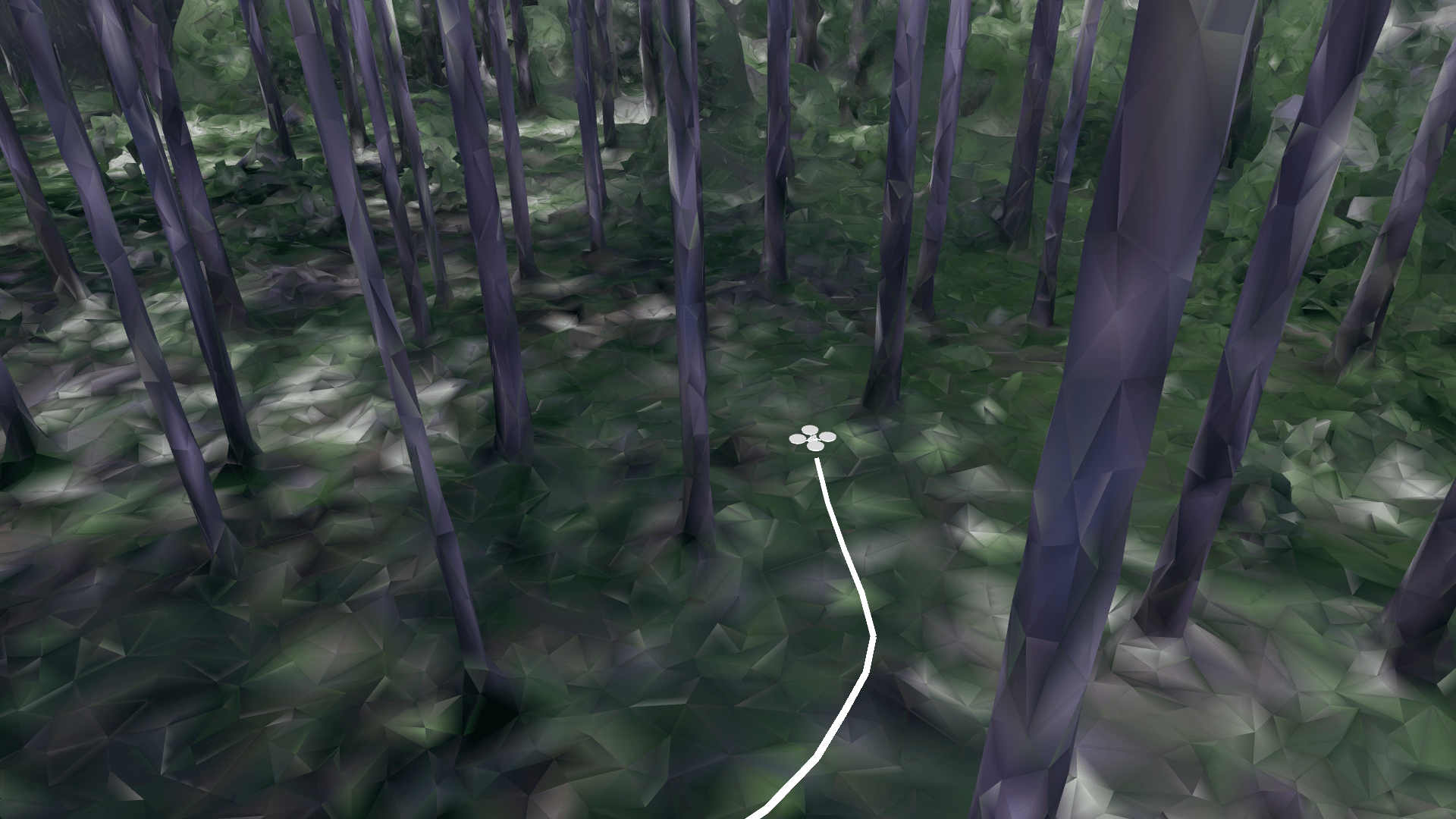
Motivated by these challenges, in this work we propose an exploration strategy for autonomous UAV robots aiming to explore forests of increasing tree density, as they pose some of the most difficult challenges for exploration planning. Our objective is to exploit the platform’s dynamics to the fullest despite the high density of obstacles, in order to achieve the complete coverage of the environment efficiently. To this end, the proposed strategy enables switching between two different behaviors for each robot; namely, cautious exploration of unknown space and more aggressive maneuvers when navigating in already explored areas to clear smaller portions of unknown space caused by occlusions. We evaluate the proposed approach in a series of challenging experiments in simulation, both in randomly generated forests and in a 3D reconstruction of a real forest (Fig 1). Benchmarking against the state of the art reveals superior efficiency for the proposed approach achieving higher overall UAV speeds and lower exploration times. Finally, aiming to set out the scaffolding toward decentralized multi-robot exploration planning, we show how the proposed strategy can accommodate more than one UAV in the exploration mission, and we demonstrate that our method performs comparably to or better than a map-splitting centralized approach.
In summary, the contributions of this work are as follows:
-
•
the design of an exploration strategy, able to strike an effective balance between cautious exploration and aggressive exploitation of the explored map,
-
•
the extension of the single-robot design to a multi-robot decentralized approach, and
-
•
extensive evaluations in simulation, demonstrating better performance than the state of the art.
II Related Works
Autonomous exploration of unknown environments with UAVs has been an active field of research over the past few decades. The most popular approach to exploring an area of interest is to use frontiers, defined as the boundary between known and unknown space [11]. These can be utilized to identify potentially informative spatial regions in order to drive the exploration process efficiently until no new frontiers are found and the exploration process can be considered complete. There are different criteria used to decide which frontier to explore next, such as their proximity to the current field of view, following a greedy selection strategy, or having global planning dictate the selection [12]. However, while frontier-based approaches have been proven to yield satisfactory performances, especially in terms of coverage [2, 3], they generally lead to inefficient motions and sub-optimal action selection. This is mostly caused by the sensing modalities used to generate the map of the environment to explore, as the most common sensors, such as RGB-D and stereo cameras, have a limited detection range. Consequently, UAVs need to fly cautiously to ensure safety. Cieslewski et al. [4] tackle this limitation, by proposing an exploration strategy that generates velocity commands based on newly detected frontiers, in a bid to maximize the UAV’s speed. This method is shown to outperform classical methods [11], but focuses only on local frontiers. Instead, FUEL [5] proposes a hierarchical planner which generates efficient global paths, while encouraging safe and agile local maneuvers for high-speed exploration. FUEL’s strategy performs better than [4] and [11] in scenes with low obstacle densities. However, it is more computationally demanding, as it needs to maintain a list of active frontiers, as well as to compute accurate distances between them. This additional bookkeeping becomes prohibitive and impractical in more cluttered and complex environments such as forests. In fact, in this type of scenery, the number of frontiers quickly increases due to occlusions caused by tree trunks, branches, and shrubs.
Another line of research focuses instead on sampling-based path planning to generate viewpoints to explore the space [13, 14], by guiding the robot along possible trails of sampled configurations. The best path is generally found using a greedy approach [14], bringing to complete exploration or accurate surface reconstruction [2] depending on the information gain formulation. Nonetheless, these sampled routes may generate trajectories that deviate from the shortest paths, without taking into consideration the robot’s dynamics. Consequently, this causes the UAV to navigate in zigzag patterns, leading to inefficient, slow motions and conservative maneuvers.
To tackle the limitations of frontier- and sampling-based methods, also hybrid approaches have been proposed [1, 15]. Such methods compute global paths towards the most informative frontiers while generating local trajectories using sampling-based planners. However, they do not exploit the full dynamics of the platform and generate sub-optimal routes.
To boost the efficiency in exploration, various multi-robot cooperative frontier-based methods have also been proposed in the literature, both in centralized [16] and decentralized formats [17]. In this spirit, the work in [18] greedily assigns view configurations, while [19] distributes the workload between agents using a Voronoi-based partitioning of the area to explore. Nevertheless, these solutions suffer from the same limitations as in the single-robot case. Instead, the approach in [20] is able to generate efficient trajectories for 3D reconstruction, tackling the multi-robot coordination with a centralized architecture. However, this method requires a prior overhead flight over the area of interest, making it unsuitable for the exploration of forests. The approach proposed in [7] puts more focus on the problem of navigating forests, but the emphasis is more on state estimation rather than on path planning.
Motivated by these limitations, in this work, we propose a strategy that allows a robot to explore complex forest-like environments while flying at high speeds, thanks to the freedom and flexibility that our planner provides to each UAV to switch between different navigation modes online. While slower, cautious exploration is performed using a frontier-based approach, we efficiently clear trails of unexplored space caused by occlusions by employing a more aggressive local exploration strategy, boosting the efficiency of the mission and pushing the overall time to cover a given area of interest down. Moreover, we demonstrate that the proposed pipeline can also be extended to the multi-robot setting in a decentralized fashion.
III Methodology
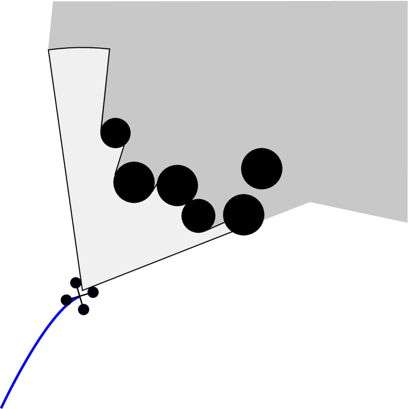
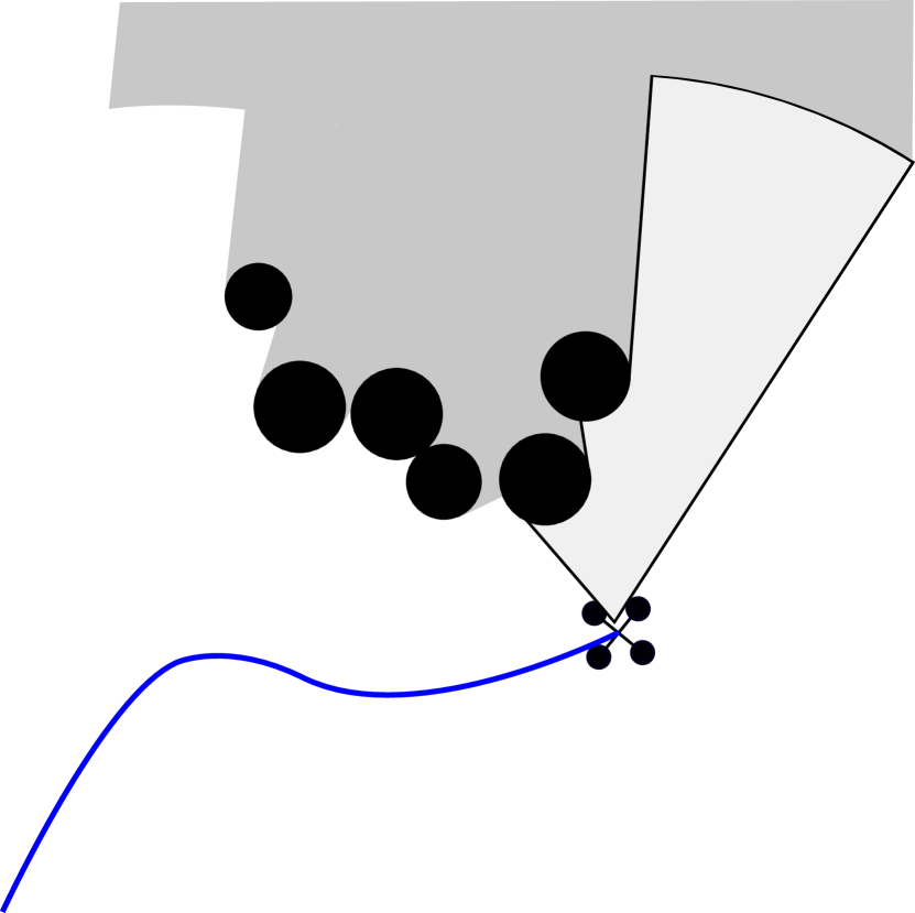
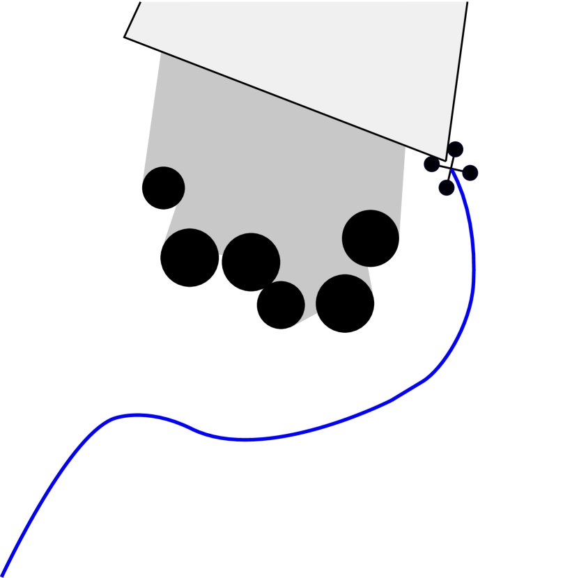
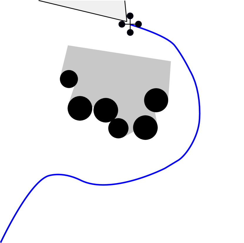
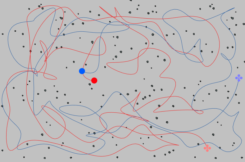
The overall problem considered in this work is to explore unknown cluttered environments, such as forests, in the minimum time possible. We assume that the robot is equipped with a front-looking depth camera with a limited sensing range and that the robot’s odometry information is available at a constant rate. However, forest-like scenes are characterized by a high number of obstacles in a variety of dimensions (e.g. trunks, leaves, and branches) that make standard frontier-based exploration approaches inefficient. In fact, during the exploration process, many islands of unknown space are usually left behind, as illustrated in Fig. 2, necessitating subsequent passes of exploration on a nearly completely explored map. To tackle this limitation, we propose an exploration pipeline that can change the exploratory behavior of the robot depending on the frontiers in its vicinity. In particular, we propose to define two different modes of operation for the robot, namely the Explorer and the Collector modes. In the Explorer state, the robot is driven by frontiers and it is tasked to explore large unknown areas. Consequently, it predominantly operates on the most external boundaries between known and unknown areas. Conversely, the robot in the Collector mode clears small islands of unknown space generated by occlusions, that are left behind during the exploratory phase. The objective of a Collector is to clear these portions of space on the go, avoiding the need for subsequent revisits of the map, at the expense of short local detours. However, notice that these can be performed at high speed, since, when in Collector mode, the robot operates in mostly explored areas. By allowing a robot to switch between these two different modes and by finding the right trade-off between map exploration and exploitation, we can quickly reach full coverage of large cluttered environments. In the following, we first give an overview of the proposed system and our exploration strategies, and then we illustrate how it can be extended to multiple robots.
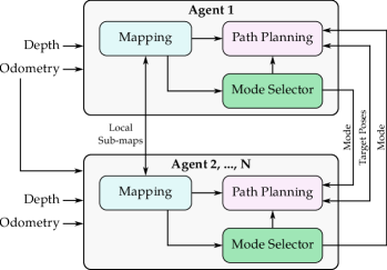
III-A System Overview

As shown in Fig. 3, the pipeline is composed of three main components: a mapping system, a mode selector, and a path planner.
Given input depth and odometry information, a voxel grid map of the environment is generated. At every update, frontiers are extracted from and clustered. For each cluster, we adopt the sampling strategy from [5] to generate viewpoints covering the frontiers, and we use them as possible target poses during the exploration process.
Moreover, each cluster undergoes a binary classification step, where unconnected islands of frontiers, or trails, are identified. This is necessary to identify those regions that are likely to require an additional revisiting phase towards the end of the mission if a traditional frontier-based exploration method is utilized. Here, a cluster is considered a trail if its convex hull is surrounded by free space, or when it has only another neighboring cluster. This implies that most clusters at the corners of the area to be explored are classified as trails. We motivate this design choice by arguing that corners are generally problematic for exploration due to their low informative value. In fact, they are rarely covered in a first sweep of the map, implying the need for a revisiting step. The labeled clusters are then utilized by the Mode Selector to choose the best exploration strategy for the robot, deciding whether it has to persevere in its current mode, or transit to Explorer or Collector. The mode assignment is regulated according to the frontiers in the vicinity of the UAV. Given that our objective is to clear trails locally to avoid large detours on the map, we assign the role of Collector if a minimum number of trails is close to the robot. Instead, we adopt a more exploratory strategy once all smaller islands of unknown space are cleared, or when the trails are far away from the drone. Once a strategy is selected, the viewpoint of the most promising cluster is selected as the new target pose. This is fed to a path planner [21] that generates the trajectory flying the UAV toward its destination. We now describe the different exploration modes in more detail.
III-B Exploration Strategies
III-B1 Explorer
Driven by frontiers, the objective of an Explorer is to cover large areas of previously unknown space. Similarly to [4], we process the incoming clusters of frontiers from the most recent map update and extract the one with the lowest cost . Notice that these clusters are mostly aligned with the direction of the UAV’s motion, implying that, if one of these is selected as the target, the robot avoids abrupt changes in the flight direction or aggressive maneuvers.
The cost associated to the viewpoint covering cluster is defined as
| (1) |
where is the position of the viewpoint and its orientation. The cost is the length of the path in between the current robot’s position and , and it is calculated using the A* algorithm. Instead, is associated with the change in direction of travel, while to the label of cluster . The terms and are constant weights.
The cost is calculated as
| (2) |
where and are the robot’s current velocity and position, respectively. This cost is directly associated with the angle between the velocity and the direction vector towards the candidate position covering cluster . However, it may happen that the cluster is labeled as trails, e.g. in the case of occlusions caused by thin obstacles, such as tree trunks. Since an Explorer should focus on actual frontiers, we assign a penalty to these clusters:
| (3) |
where is the constant penalty associated with trails.
We then select as target pose the next best viewpoint covering the cluster with the lowest cost:
| (4) |
In case the UAV is trapped in a dead-end, or if no new clusters are available in front of the robot, we ignore the cost associated with the robot’s velocity and we employ a greedy approach to select the new target pose. We find the best cluster in the vicinity of the robot at a maximum distance using the same cost function as in Eq. 1, with set to zero:
| (5) | ||||
III-B2 Collector
The objective of a Collector is to clear as many trails as possible, in order to avoid the need for a revisiting step in poorly explored regions of the map at the end of the mission. Since this task implies a detour from the main direction of exploration, the UAV’s speed needs to be maximized in order to go back to Explorer mode as soon as possible. To reach this objective, we sort the set of trails by associating a cost to each cluster :
| (6) |
where is associated with the time to reach and with the time to cover the angular change between the current robot’s yaw and the viewpoint’s orientation. Instead, and are constant weights.
Given the path from to and the maximum allowed velocity , is computed as
| (7) |
Similarly, given the robot current’s heading , the viewpoint’s orientation and the maximum allowed yaw rate , is computed as
| (8) |
where indicates the angular difference between and .
The robot then selects the target trail in a step-by-step greedy procedure and behaves as a Collector until all close-by trails are cleared. Since the trails are surrounded by free known space, we double the maximum velocity compared to when in Explorer mode. Consequently, the UAV is able to maximize its velocity, leading to fast motions that allow it to quickly cover all the viewpoints associated with the trails.
III-C Extension to Multi-Robot
III-C1 System Architecture
The proposed exploration strategy can be easily extended to the multi-robot case. The extended pipeline is shown in Fig. 4. Assuming that the agents can localize in a common reference frame, they exchange local sub-maps, as well as odometry information, current target pose, and execution mode. Notice that here we propose a decentralized architecture. Centralized approaches generally assume infinite-range communication between agents and with a ground station. However, standard Wi-Fi communications have a limited range and, when navigating in cluttered environments such as forests, communication lines can be potentially obstructed and signal can be lost. In this work, we propose to use a more flexible point-to-point strategy, assuming that there exists a maximum range of communication between each pair of agents. Our design targets to keep the agents at a valid communication distance. If the distance between agents is higher than the maximum range, communication is lost and information is not exchanged anymore, leading to poor inter-agent coordination and sub-optimal decision-making. We also assume that, when communication is lost and successively regained, agents can synchronize their maps.
III-C2 Multi-robot Coordination
We encourage coordination between pairs of agents only if they perform compatible actions from an exploration point of view. This implies that, if two UAVs are operating in the same mode, they can collaborate in order to either explore more unknown spaces (Explorers) or clear trails (Collectors). On the contrary, coordination between an Explorer and a Collector should not be encouraged, since their tasks are intrinsically different. In this situation, we propose a leader-follower paradigm, where the Explorer (leader) explores unknown areas regardless of the position of the second agent, while the Collector (follower) follows the leader and clears the trails left unexplored. This design choice allows more flexibility during the execution of a mission, thanks to the possibility to change execution modes online. Notice that, if communication between all agents is lost, their exploration strategy falls back to the single-robot case.
Our collaboration strategy within a robotic team is encouraged as a soft constraint by modifying the cost functions in Eq. 1 and Eq. 6. If we consider robot with position , given the positions of the other robots in the team with , and their current target positions , we modify the cost functions and for robot as follows:
| (9) |
and
| (10) |
where is a constant weight. The cost function is defined as
| (11) |
where aims at keeping the agents and in communication range, while ensures a minimum distance between them to avoid collisions. Moreover, encourages map splitting, by assigning a high cost to candidate target positions close to other agents’ current goals.
In more details, the function for agent is defined as follows:
| (12) |
where is constant factor and is an indicator function that embeds our coordination strategy:
| (13) |
This indicates that agent is attracted toward agent only if they are in a compatible execution mode. On the contrary, in leader-follower mode, i.e. when robot is an Explorer and robot is a Collector, the leader ignores the follower, and goes to zero. Notice that instead, if is Collector and an Explorer, and .
Instead, is computed as follows:
| (14) |
where, given the Euclidean distance ,
| (15) |
The parameter is a constant weight, while represents the minimum distance between positions and to have a collision. The parameter represents the distance after which the positions should not approach any closer. This can be selected on the basis of the safety distance required between the UAVs. Notice that is not influenced by the roles of agents and , as safety and minimum distance requirements need to be always met.
IV Experiments
We evaluate the proposed exploration pipeline in both single- and multi-UAV setups in simulation. In particular, we benchmark our method on a series of realistic, randomly generated forests of increasing tree densities [22], as well as on a 3D reconstruction of a real forest [6].
In the single-agent setup, we compare the proposed method against FUEL [5], while in the experiments with multiple robots we test against a centralized strategy based on map-splitting. In all tests, we use grid map resolutions of or depending on the map size, while we set the dynamic limits to and for all planners. We simulate a depth camera with a fixed range of using the Vulkan-based renderer of [23] and the same physical simulator as in [5]. We report the planners’ performance in terms of the time needed to complete the exploration of the scene, the total travelled distance, and the average velocity of the UAVs during each experiment.
IV-A Single-robot Experiments
| Ours | FUEL [5] | |
| Real Forest | ||
| Completion Time [] | 500.7 14.8 | 757.7 47.9 |
| Travelled Distance [] | 645.0 20.0 | 533.2 11.0 |
| Velocity [] | 1.3 0.5 | 0.7 0.4 |
| Sparse Forest (0.05 trees / ) | ||
| Completion Time [] | 665.4 32.7 | 1114.1 97.4 |
| Travelled Distance [] | 860.9 34.0 | 758.1 57.6 |
| Velocity [] | 1.3 0.6 | 0.7 0.5 |
| Average-Density Forest (0.10 trees / ) | ||
| Completion Time [] | 779.6 110.9 | 954.1 28.8 |
| Travelled Distance [] | 910.3 63.7 | 713.5 33.1 |
| Velocity [] | 1.2 0.6 | 0.7 0.5 |
| Dense Forest (0.15 trees / ) | ||
| Completion Time [] | 613.2 16.2 | 1130.2 28.8 |
| Travelled Distance [] | 789.7 16.8 | 791.0 37.7 |
| Velocity [] | 1.2 0.6 | 0.7 0.5 |
| Very Dense Forest (0.20 trees / ) | ||
| Completion Time [] | 658.2 57.2 | 904.1 109.5 |
| Travelled Distance [] | 802.0 52.7 | 680.6 49.9 |
| Velocity [] | 1.2 0.6 | 0.7 0.5 |
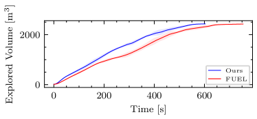
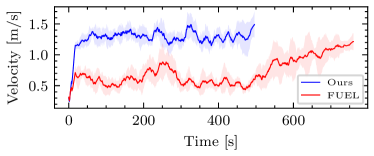
In the single-robot experiments, the models of the synthetic forests are of size , while the 3D reconstruction of the Real Forest has dimensions . The map resolution is set to . As reported in Table I, the proposed planner outperforms FUEL [5] across all scenes in terms of the time taken to reach full coverage (Fig. 5), thanks to our adaptive exploration policy that leads to consistently higher UAV velocity throughout each mission, as illustrated in Fig. 6. These results demonstrate the benefit of using the proposed adaptive exploration strategy over a fixed-mode method. However, notice that the proposed design leads to longer travelled distances, albeit guaranteeing that there are no small unexplored areas left. In fact, decision-making both in Explorer and Collector modes is done on a local-map level, and this may cause the UAV to fly longer routes, deviating from the shortest path. Nonetheless, in the proposed strategy we compensate for this shortcoming by encouraging decisions leading to higher UAV velocities, and thus shorter mission times.
IV-B Multi-robot Experiments
In the multi-robot experiments, the proposed planning strategy is tested in a variety of models with fixed, homogeneous obstacle density, as well as in a randomly generated forest with tree density varying across different regions of the map.
IV-B1 Maps with a fixed tree density
| Ours | Split Map (FUEL [5]) | |
| Sparse Forest (0.05 trees / ) | ||
| Completion Time [] | 780.3 32.2 | 834.3 64.3 |
| Travelled Distance [] | 958.8 9.2 | 595.7 51.8 |
| 958.7 60.4 | ||
| Velocity [] | 1.2 0.6 | 0.7 0.4 |
| 1.3 0.7 | ||
| Average-Density Forest (0.10 trees / ) | ||
| Completion Time [] | 838.5 64.4 | 848.1 98.5 |
| Travelled Distance [] | 915.3 68.4 | 616.1 40.7 |
| 906.2 58.3 | ||
| Velocity [] | 1.2 0.5 | 0.8 0.4 |
| 1.1 0.6 | ||
| Dense Forest (0.15 trees / ) | ||
| Completion Time [] | 786.3 40.7 | 754.0 23.9 |
| Travelled Distance [] | 839.0 26.1 | 586.7 14.2 |
| 882.2 32.0 | ||
| Velocity [] | 1.2 0.7 | 0.8 0.4 |
| 1.3 0.7 | ||
| Very Dense Forest (0.20 trees / ) | ||
| Completion Time [] | 803.7 52.8 | 705.8 73.2 |
| Travelled Distance [] | 873.8 47.0 | 580.3 73.3 |
| 912.6 42.7 | ||
| Velocity [] | 1.2 0.7 | 0.7 0.5 |
| 1.2 0.8 | ||
The results of the multi-robot collaborative exploration strategy of maps with fixed tree densities with two agents are shown in Table II, where a maximum connection distance of for data exchange between agents is assumed (Fig. 7). Here, experiments are performed in forest models of size with a map resolution of . The proposed approach is compared against a centralized strategy we devised, employing the FUEL planner [5] and assigning the UAVs to explore maps of equal sizes (i.e. using map-splitting). Note that this strategy assumes homogeneous forest maps, and knowledge of the original map size, which renders this unsuitable for realistic deployment unlike the proposed approach; however, comparisons are presented for the sake of benchmarking.
The proposed strategy reaches comparable results with respect to the centralized approach using FUEL. Similarly to single-robot exploration, the proposed strategy flies the UAVs at higher speeds, incurring longer travel distances. Moreover, our strategy enables automatic load balancing of the exploration mission, yielding similar exploration rates per agent as illustrated in Fig. 8. However, in denser forest models, the performance of the proposed approach is seen to degrade, as the UAVs are tasked to fly within a connection range to each other, resulting in limited freedom of movement. This is exacerbated by the increased number of obstacles and occlusions in smaller maps, leading to lower exploration rates. Nevertheless, as aforementioned, the proposed approach is realistically deployable in contrast to the baseline strategy using FUEL.
IV-B2 Map with non-homogeneous tree density
The results of the experiments in a map with non-homogeneous obstacle densities with a team of two agents are shown in Table III. We utilize a model with size , with different tree densities (, and trees/) across distinct map regions. The occupancy grip map resolution is set to , with a maximum inter-agent communication range of . We perform the same analysis as in Sec. IV-B1, assuming a realistic maximum flight time of for the UAVs. As none of the tested planners is able to fully explore the environment within the allowed time, we report the total team coverage at fixed timestamps. The proposed approach consistently outperforms the solution based on map-splitting using FUEL [5] as the planning back-end. The gain in performance is related to the capacity of our strategy to fly the UAVs faster in regions with lower obstacle density and to explore cautiously more cluttered areas while clearing smaller frontier trails on the go. This leads to a more efficient exploration process, able to better exploit the capacity of UAVs to perform highly dynamic flights.
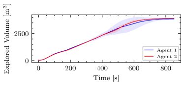
Finally, we report the performance of our method when a team of three robots is deployed. As shown in Table IV, a larger team size yields higher total coverage. This demonstrates that this work presents an effective strategy for peer-to-peer sharing of the responsibility of exploration of a large forest area and that the extension to larger teams of multiple UAVs can be realized following this paradigm, pushing for scalable, decentralized multi-robot planning for exploration.
| Ours | Split Map (FUEL [5]) | |
|---|---|---|
| Travelled Distance [] | 1481.9 467.0 | 735.2 500.1 |
| 1487.0 440.8 | 697.1 365.6 | |
| Velocity [] | 1.3 0.6 | 0.7 0.4 |
| 1.2 0.7 | 0.6 0.5 | |
| Explored Volume [] - | 542.3 23.3 | 514.6 313.0 |
| 565.9 31.4 | 632.0 184.8 | |
| Explored Volume [] - | 1062.8 81.3 | 840.0 580.7 |
| 1011.6 65.3 | 728.3 163.5 | |
| Explored Volume [] - | 1400.0 265.3 | 1145.3 814.7 |
| 1302.6 110.5 | 798.8 146.2 | |
| Explored Volume [] - | 1626.7 431.2 | 1330.1 905.3 |
| 1466.5 185.4 | 910.4 83.9 | |
| Explored Volume [] - | 1816.0 550.8 | 1437.8 971.8 |
| 1637.0 299.1 | 1040.5 124.3 |
| Timestamp | Two Agents | Three Agents |
|---|---|---|
| 1208.0 91.6 m3 | ||
| 2098.4 143.8 m3 | ||
| 2748.3 111.9 m3 | ||
| 3223.5 127.9 m3 | ||
| 3621.8 321.0 m3 |
V Conclusion and Future Work
In this work, we propose an exploration pipeline for autonomous UAVs operating in complex, cluttered environments, with a particular focus on forests. We choose this type of environment as one of the inherently most challenging for effective planning due to the increased number of obstacles and occlusions that they exhibit. The proposed strategy allows each UAV to switch between different exploratory behaviors, autonomously balancing cautious exploration of unknown space and more aggressive maneuvers, exploiting already mapped space within a mission. This leads to faster completion times due to higher-speed flights and, consequently, to more efficient and faster map coverage than the state of the art. Moreover, we show how the proposed method can be extended to three, and potentially more robots in a decentralized fashion, demonstrating automatic and effective load balancing across the participating agents. Following the push for automating higher-level decision-making in robotic missions, this work constitutes a key milestone towards effective exploration planning for robotic teams.
The natural next step for this work is to address the integration and deployment of the proposed pipeline onboard real platforms, while further investigations will push advancing coordination strategies in larger multi-robot teams.
References
- [1] M. Selin, M. Tiger, D. Duberg, F. Heintz, and P. Jensfelt, “Efficient Autonomous Exploration Planning of Large-Scale 3-D Environments,” IEEE Robotics and Automation Letters, 2019.
- [2] L. Schmid, M. Pantic, R. Khanna, L. Ott, R. Siegwart, and J. Nieto, “An Efficient Sampling-Based Method for Online Informative Path Planning in Unknown Environments,” IEEE Robotics and Automation Letters, 2020.
- [3] Y. Kompis, L. Bartolomei, R. Mascaro, L. Teixeira, and M. Chli, “Informed Sampling Exploration Path Planner for 3D Reconstruction of Large Scenes,” IEEE Robotics and Automation Letters, 2021.
- [4] T. Cieslewski, E. Kaufmann, and D. Scaramuzza, “Rapid exploration with multi-rotors: A frontier selection method for high speed flight,” in 2017 IEEE/RSJ International Conference on Intelligent Robots and Systems (IROS), 2017.
- [5] B. Zhou, Y. Zhang, X. Chen, and S. Shen, “FUEL: Fast UAV Exploration Using Incremental Frontier Structure and Hierarchical Planning,” IEEE Robotics and Automation Letters, 2021.
- [6] A. Ahmad, V. Walter, P. Petráček, M. Petrlík, T. Báča, D. Žaitlík, and M. Saska, “Autonomous Aerial Swarming in GNSS-denied Environments with High Obstacle Density,” in 2021 IEEE International Conference on Robotics and Automation (ICRA), 2021.
- [7] Y. Tian, K. Liu, K. Ok, L. Tran, D. Allen, N. Roy, and J. P. How, “Search and rescue under the forest canopy using multiple UAVs,” The International Journal of Robotics Research, 2020.
- [8] T. Rouček, M. Pecka, P. Čížek, T. Petříček, J. Bayer, V. Šalanskỳ, D. Heřt, M. Petrlík, T. Báča, V. Spurnỳ et al., “Darpa subterranean challenge: Multi-robotic exploration of underground environments,” in International Conference on Modelling and Simulation for Autonomous Systems. Springer, 2019.
- [9] L. Bartolomei, M. Karrer, and M. Chli, “Multi-robot Coordination with Agent-Server Architecture for Autonomous Navigation in Partially Unknown Environments,” in 2020 IEEE/RSJ International Conference on Intelligent Robots and Systems (IROS), 2020.
- [10] M. Corah, C. O’Meadhra, K. Goel, and N. Michael, “Communication-efficient planning and mapping for multi-robot exploration in large environments,” IEEE Robotics and Automation Letters, 2019.
- [11] B. Yamauchi, “A frontier-based approach for autonomous exploration,” in Proceedings 1997 IEEE International Symposium on Computational Intelligence in Robotics and Automation CIRA’97, 1997.
- [12] D. L. da Silva Lubanco, M. Pichler-Scheder, and T. Schlechter, “A novel frontier-based exploration algorithm for mobile robots,” in 2020 6th International Conference on Mechatronics and Robotics Engineering (ICMRE), 2020.
- [13] C. Connolly, “The determination of next best views,” in Proceedings. IEEE International Conference on Robotics and Automation, 1985.
- [14] A. Bircher, M. Kamel, K. Alexis, H. Oleynikova, and R. Siegwart, “Receding Horizon ”Next-Best-View” Planner for 3D Exploration,” in 2016 IEEE International Conference on Robotics and Automation (ICRA), 2016.
- [15] B. Charrow, G. Kahn, S. Patil, S. Liu, K. Goldberg, P. Abbeel, N. Michael, and V. R. Kumar, “Information-theoretic planning with trajectory optimization for dense 3d mapping,” Robotics: Science and Systems XI, 2015.
- [16] A. Mannucci, S. Nardi, and L. Pallottino, “Autonomous 3D Exploration of Large Areas: A Cooperative Frontier-Based Approach”,” in Modelling and Simulation for Autonomous Systems. Cham: Springer International Publishing, 2018.
- [17] R. G. Colares and L. Chaimowicz, “The next frontier: combining information gain and distance cost for decentralized multi-robot exploration,” Proceedings of the 31st Annual ACM Symposium on Applied Computing, 2016.
- [18] G. Hardouin, J. Moras, F. Morbidi, J. Marzat, and E. M. Mouaddib, “Next-Best-View planning for surface reconstruction of large-scale 3D environments with multiple UAVs,” in 2020 IEEE/RSJ International Conference on Intelligent Robots and Systems (IROS), 2020.
- [19] A. Dutta, A. Bhattacharya, O. P. Kreidl, A. Ghosh, and P. Dasgupta, “Multi-robot informative path planning in unknown environments through continuous region partitioning,” International Journal of Advanced Robotic Systems, 2020.
- [20] D. Morilla-Cabello, L. Bartolomei, L. Teixeira, E. Montijano, and M. Chli, “Sweep-Your-Map: Efficient Coverage Planning for Aerial Teams in Large-Scale Environments,” IEEE Robotics and Automation Letters, 2022.
- [21] B. Zhou, F. Gao, L. Wang, C. Liu, and S. Shen, “Robust and Efficient Quadrotor Trajectory Generation for Fast Autonomous Flight,” IEEE Robotics and Automation Letters, 2019.
- [22] H. Oleynikova, M. Burri, Z. Taylor, J. Nieto, R. Siegwart, and E. Galceran, “Continuous-Time Trajectory Optimization for Online UAV Replanning,” in IEEE/RSJ International Conference on Intelligent Robots and Systems (IROS), 2016.
- [23] L. Bartolomei, Y. Kompis, L. Teixeira, and M. Chli, “Autonomous Emergency Landing for Multicopters using Deep Reinforcement Learning,” in 2022 IEEE/RSJ International Conference on Intelligent Robots and Systems (IROS), 2022.