2021
[1]\fnmZizhang \surWu
These authors contributed equally to this work.
These authors contributed equally to this work.
These authors contributed equally to this work.
These authors contributed equally to this work.
These authors contributed equally to this work.
These authors contributed equally to this work.
[1]\orgdivZongmu Technology 2]\orgdivTechnical University of Braunschweig
OCR-RTPS: An OCR-based real-time positioning system for the valet parking
Abstract
Obtaining the position of ego-vehicle is a crucial prerequisite for automatic control and path planning in the field of autonomous driving. Most existing positioning systems rely on GPS, RTK, or wireless signals, which are arduous to provide effective localization under weak signal conditions. This paper proposes a real-time positioning system based on the detection of the parking numbers as they are unique positioning marks in the parking lot scene. It does not only can help with the positioning with open area, but also run independently under isolation environment. The result tested on both public datasets and self-collected dataset show that the system outperforms others in both performances and applies in practice. In addition, the code and dataset will release later.
keywords:
Positioning system, Parking OCR, Deep Learning, Valet parking1 Introduction
Classical positioning technologies such as GPS (Global Positioning System) and RTK (Real Time Kinematic) are widespread in autonomous driving bib1 ; bib2 ; bib3 ; bib4 , but they are limited by the weak signal under isolation scenes bib5 ; bib6 , other technologies such as LIDAR, which locates itself by matching the cloud points with the prepared template bib7 ; bib8 ; bib9 , require the high economic and computational cost bib9 . Therefore, how to obtain the position of vehicles at low expenses in an isolated parking scene, especially the underground parking lot, is an urgent problem to solve.
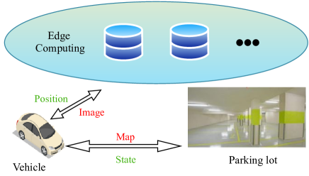
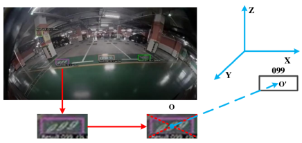
Observing that the parking number is a fixed and unique sign in the parking lot. With the development of Optical Character Recognition (OCR) bib10 ; bib11 ; bib12 , deep learning-based methods bib13 ; bib14 greatly improve the recognition accuracy and the generalization ability to different scenes bib15 . These properties make it possible to locate and recognize characters in arbitrary scenes bib16 ; bib17 . Considering that, we propose an integrated vehicle positioning system for parking scenes as shown in Fig.1 and the framework shown in Fig.2.
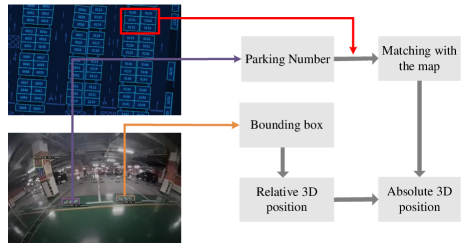
Firstly, we employ a text spotting network (ABCNet bib13 ) to obtain the recognition result of the parking number, the following step is to check the position of the result at the High Definition Map (HD Map) to get its absolute position. Subsequently, The homography matrix is solved using the detected result to obtain the relative position between ego vehicle and parking number. Finally, we combine the relative position with the absolute position of the parking number in the parking lot coordinate system to output the ego vehicle’s location. Our contributions can be summarized as follows:
-
•
We first propose an integrated positioning system based on the parking number under the valet parking scene.
-
•
We establish and annotate a parking number dataset based on the surround-view fisheye camera system to promote the research of related communities.
-
•
We conducted a large number of comparative experiments and ablation experiments on isolated and open scenarios and verified the superiority of the positioning system.
The other parts of the paper are organized as follows. The second section of the paper introduces the related methods of the paper. The third section introduces an overview of the method in this paper. The fourth part describes the new dataset (Parking OCR Dataset) we proposed in detail. The fifth section describes the experimental comparison and analysis of the method proposed in this paper. the sixth section is the discussion of the total positioning system. Finally, the seventh section is about the overall summary of the paper.
2 Related Work
2.1 High Definition Map
The first High Definition Map(HD Map) was born in 2014 in a Mercedes Benz workshop, for the project Bertha Drive Project bib26 . The HD Map is usually defined as three layers which are Open Street Map (road network), Lane level map, and Landmarks/road markings map bib27 ; bib41 ; bib42 ; bib43 ; bib44 ; bib45 ; bib46 . The Open Street Map (road network) bib44 ; bib45 is used to plan the overall route, the Lane level map bib42 helps the vehicle to perceive the current traffic conditions such as roads or obstacles ahead, and the Landmarks/road markings map bib46 can locate the exact position of the vehicle to change lanes. With the above three layers of functions, we can locate the specific position of the vehicle in the HD map for vehicle perception. Generally, the absolute accuracy of a high precision map is less than one meter, and the relative accuracy reaches the centimeter level usually in 10 to 20 centimeters. In addition, a complete high-precision map should also include road information, such as the number of lanes, traffic lights, crosswalks, lane curvature or slope; rule information, such as speed limits and driving restrictions; real-time information, such as traffic accidents, traffic weather, etc. In a word, high-precision maps play a very important role in the development of autonomous driving.
2.2 Detection-based methods
Such methods bib25 ; bib28 ; bib29 ; bib30 ; bib31 generally get object detection frames first by popular frameworks under the supervision of word or line-level annotations. CPTN bib25 and SegLink bib28 both find text candidates first and then join them in post-processing to get text lines, but require the text to be all horizontal. EAST bib29 divides text detection into a fully convolutional network stage and an NMS (Non-Maximum Suppression) stage, which can predict rotated and horizontal lines of text. PSENet bib30 uses ResNet as the backbone to increase the generalization ability to detect text boxes, which can be widely used in various scenarios. DBNet bib31 proposes differential binarization to generate robust binarized graphs, which greatly simplifies the post-processing process and improves the speed of computation. All of the above methods process text by first detecting and then recognizing, so the result of detection plays a crucial role in the accuracy of recognition.
2.3 End to end text spotting
In recent years, deep learning has become one of the most popular directions in artificial intelligence because of its powerful learning and generalization capabilities. Simple scenes based on traditional techniques of the connected domain and sliding window methods can have good results. However, when the image text is distorted, deflected, and the font changes, the detection task of traditional methods completely lags behind that of deep learning methods. End-to-end-based text detection methods should have better robustness and be able to extract high-level features of the scene. With more diverse sample training, deep learning-based OCR techniques have made a breakthrough. In the end-to-end-based methods of detection and recognition, bib32 ; bib33 ; bib34 are highly correlated and complementary, so they can share feature maps in the same model. Li H bib32 proposes a new method of region feature extraction. This feature extraction method can be well-compatible with text bounding boxes with different original aspect ratios to balance the image distortion. FOTS bib33 proposes the use of the RoI Rotate module, which bridges the detection and recognition modules. CharNet bib34 has two branches, the first branch is used for character detection and overall recognition; another branch detects each text within a character(single text or character). This complementary structure avoids recognition errors due to detection errors.
2.4 Wireless based positioning
In some indoor scenarios, such as parking lots, and underpasses, it can lead to inaccurate or delayed GPS and RTK positioning. Therefore, in the 21st century where WiFi is widely used, it is very convenient to use wireless signals to locate a car bib35 ; bib36 ; bib37 ; bib38 ; bib39 ; bib40 ; bib47 ; bib48 ; bib49 . WiFi positioning is mainly based on signal strength, fingerprint, angle of arrival, and time of flight. Typically, to determine the target location the distance between the target device and several wifi signal devices is first obtained. Then the relative position of the target device is determined using trilateral measurements, or the angle between the transmitted signals is used to calculate the position of the target. The wifi-based positioning system bib50 is divided into two types: active positioning bib51 ; bib52 ; bib53 ; bib54 and passive positioning bib55 ; bib56 ; bib57 . Li W bib52 proposes a method by utilizing both TOA and RSS measurements. Their purpose is to analyze the difference between TOA and RSS geometric areas to obtain an optimized range of data. Then, these data are introduced into the triangular centroid algorithm to achieve positioning. There are also other methods proposed to improve the accuracy of locating a moving object indoors, such as the TOA/IMU indoor positioning system bib53 . Oguntala et al. bib56 use the ranging method of passive RFID receiving signal strength to achieve personnel positioning. The particle filter algorithm analyses and calculates RSSI to get the target position in the indoor environment. Wang X bib57 purpose CSI phase information is used for indoor fingerprinting and the feasibility of utilizing the calibrated phase information of CSI for indoor positioning is proved. Indoor positioning technology based on WiFi has been widely studied due to its advantages of low cost, wide application, and strong applicability. However, since signal fluctuations may increase localization errors, wifi traces can be blended with other data sources to improve accuracy.
2.5 positioning system under isolated scenes
Most methods are based on GPS, RTK, WiFi, and other media. In contrast, the positioning method in the isolation scenario does not need to use these media to achieve its positioning, which is worthy of in-depth research. Xia C bib71 proposed a self-positioning framework without relying on GPS or any other wireless signals. It is proven that the uniform normal distribution changes and two-way information interaction mechanism can achieve the accuracy of the centimeter level, which meets the requirements of autonomous driving cars to achieve real-time stability. Ramasamy P bib72 established an analysis model, which integrates the geographical reference data from GPS and the signal captured by the visual sensor together to achieve positioning. The simulation results of the study show that compared with the existing methods, the proposed research provides accuracy and faster treatment of improvement. The above studies have effectively improved positioning accuracy in isolation scenarios. However, it rarely uses OCR technology to achieve effective positioning. This Paper will conduct in-depth research on customs in the automatic parking process.
3 Methodology
3.1 Overall framework
The proposed system includes a text recognition module, a video-stream-based anomaly filtering module, and a positioning projection module.
To obtain the vehicle’s location, we first employ the text recognition module to capture the location, content, and category of text instances(Fig.2). Then, these results are sent into the anomaly filtering module to ensure the consistency of positioning. Subsequently, we acquire the parking number’s absolute position by matching the detected characters and their corresponding position on the prepared HD Map. In the positioning projection module, the final location is generated by merging the relative distance and orientation between the parking number and the driving vehicle with the absolute location of the parking number.
3.2 Text recognition module
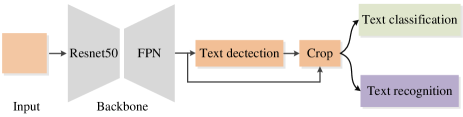
Fig.3 illustrates the proposed text recognition module. It is noticeable that any OCR methods can be used in this module, in this paper, We employ ABCNet bib13 to perform text detection tasks and text recognition tasks, and we stack an additional text classification head to determine if the text instance is a parking number. The input image goes through the backbone (Resnet50 bib18 & Feature Pyramid Networks bib19 ) firstly, and the obtained feature maps are fed to the text detection head to acquire the bounding box. Then, to get the category of text instances(parking lot instances, car plate instances, pillar instances, etc.) the predicted bounding boxes are expanded with different ratios to crop the feature maps, this can help the bounding boxes to capture surrounding information and improve the classification performance subsequently. In practice, we take 2 as the expanding ratio. Finally, we feed these expanded feature maps into the classification head and recognition head to get the instance’s category and its content.
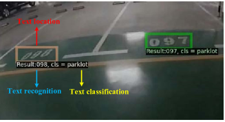
Taking the most left text instance shown in Fig.4 as an example, the text recognition module outputs three results: location, class, and content. The location indicates its coordinates (brown box), the class means the category(parking lot in this example) and the content is the recognition result (”098”).
3.3 Anomaly filtering module
Regarding the failing cases of the text recognition module which are caused by various lighting conditions, occluded parking numbers, different parking angles, etc. We propose an anomaly filtering module to ensure the accuracy and smoothness of localization.
3.3.1 The robustness of model
To minimize the anomalies, we first train the OCR model under various conditions (weak/bright lighting, rotated/blocked text). When training data is ideal, it is easy to identify errors in some special circumstances, such as blocking, brightness, blur, etc. The use of data enhancement methods for training data can enhance model robustness, and also improves the generalization ability of the model. Therefore, we apply some techniques such as data enhancement (flipping, resizing, style conversion, etc.). In Table 2, we conduct experimental comparisons with different amounts of data after data augmentation on the Parking OCR dataset.
3.3.2 The Video-stream based anomaly filter
This module is proposed to filter out the wrong recognition results produced by the OCR module, it utilizes the prior knowledge that the parking numbers change linearly within a fixed range in the parking lot and the abnormal detection will exceed this range. We first initialize a queue and keep inputting incoming numbers until it is full, since the OCR module has high accuracy, it can promise that most results in the queue are correct. Then, new coming results will be checked if there are in the range using the box plot algorithmbib20 . As shown in Algorithm 1, the queue stores the prediction results of the previous 30 frames, which ensures the continuity of the parking number in the queue. Using the box plot algorithmbib20 , anomalies are detected by calculating the lower-quartile, median, upper-quartile and , and checking if the results in the range of . Although operations such as swerve will destroy the continuity, it will re-validate within 3 seconds once other parking numbers are recognized.
The advantage of this module lies in the robustness to the anomaly. The anomaly can be effectively filtered out when the most recognized parking numbers are correct (from upper quartile to lower quartile). Besides, the algorithm complexity is , which guarantees real-time requirements.
3.3.3 The exact matching mechanism
To filter out those wrongly recognized parking numbers that do not exist in the parking lot, we employ the exact matching mechanism. it requires the recognized parking number to exactly match the parking number on the HD map, and will be abandoned otherwise.
3.4 Positioning projection module
In this module, we obtain the physical coordinates of the parking number relative to the ego-vehicle by using the homography matrix bib21 ; bib22 ; bib23 . The homography matrix projects the position from the image to the physical ground plane.
Firstly, to get the homography matrix from the image to the physical ground plane, we assume that the ground is a plane and use homogeneous coordinates to express the process of mapping a point on the ground to a point in the image plane. is a three-dimensional coordinate and can be written as . By removing the axis, we can get the following equation:
| (1) |
where is the two-dimensional coordinate: , is the scale factor which represents the scale ratio between these two planes. So the homography matrix is a matrix.
| (2) |
We can substitute equation (2) into equation (1) to get:
| (3) |
Finally, the homography matrix can be solved by at least 4 pairs of points (any 3 points are not collinear), and then its inverse matrix can help to calculate the conversion from image coordinates to physical coordinates.
By querying the known semantic map, we can obtain the location of the parking number in the physical coordinates. As shown in Fig.5, we calculate the center point coordinates of text, which is filtered by the anomaly filtering algorithm. After obtaining the relative coordinates between the text center and the vehicle, we can get the absolute position of the ego-vehicle in the physical coordinate system.
3.5 Multi camera positioning
Multi cameras are applied to increase the precision of both absolute positioning and relative positioning. Regarding improving the accuracy of calculating the relative position between parking number and ego vehicle, we use four cameras installed on each side of the vehicle and calculate their relative position to the parking number. The final position is obtained by averaging these results. Besides, this strategy also improves the accuracy of absolute positioning, because the abnormal detection will be removed (As described in section 3.3) and the more parking numbers we have seen means the more correct parking numbers we get.
4 Parking OCR Dataset
In this section, we introduce our Parking OCR Dataset in detail, including the data collection, informative statistics, and dataset characteristics.
4.1 Data Collection
To ensure the diversity of Parking Text, we collect data from different cities, different parking lots, different periods, and different text cases. To be specific, we collect a total of 3 cities, 9 parking lots, two periods (morning and evening), and capture 50 videos. These videos last from 1 hour to 6 hours with an average of 2 hours, which includes lots of Parking scene text. We divide videos into 3 categories: Pillar Text, Park lot Text, and Other Text, according to the videos’ content.
We convert the videos into pictures, then pick out the images containing Parking text instances. For high-quality images, we restrict the visible range of the fisheye camera and further remove distorted and blurred Parking text images. Additionally, we select the best-quality images, then cover all Parking Text’ continuous moving process for redundant annotations.
Finally, we finish collecting the first large-scale fisheye character recognition dataset for parking scenes: Parking OCR Dataset. A total of more than 18 thousand images with the amount of 16744 text instances respectively. Besides, Parking OCR Dataset further performs partition into training, validation, and testing sets with the ratio of 7:2:1.
4.2 Dataset Description
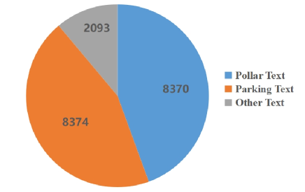
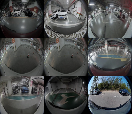
Since there is no open-sourced text recognition (OCR) dataset for the parking scene, we establish a large-scale Parking OCR Dataset(Parking Optical Character Recognition Dataset) to show the effectiveness of the proposed system and boost relevant research. As shown in Table 1, the proposed dataset includes text instances under various conditions (weak/strong light and blurry text, etc.) that belong to different parking objectives (parking number, floor indicator on the pillar, license plate characters, and parking sign, etc.). The distribution of the three categories in the Parking OCR Dataset is shown in Fig.6. For each text object, its label includes a bounding box, control points of the bounding box, classification, and content. The Parking OCR dataset contains a total of nine parking lot scenes, as shown in Fig.7.
4.3 Dataset Characteristic
Our Parking OCR Dataset exhibits different from public datasets in image representation style, scenarios, quantity, diversity, and multi-purpose. Below we shall elaborate on the five main characteristics of our Parking OCR Dataset.
Fisheye image representation.
Parking OCR Dataset consists of fisheye images, different from the common pinhole images of public datasets. Fisheye images provide a larger field-of-view (FoV), which is more suitable for close-range text detection.
Specifically for parking scenarios.
Parking OCR Dataset focuses on text detection in parking scenarios, also distinct from natural scenes of public datasets. Environmental conditions in parking scenarios, such as light and opacity, significantly increase the detection difficulty. Concerning a variety of tough text scenarios, Parking OCR Dataset can promote research in dealing with real-world recognition problems.
Great quantity.
Our Parking OCR Dataset obtains more than 18 thousand data from more than 100 hours of parking scene video clips(it will continue to expand in the future). We constantly collect diverse parking text scenarios, eventually reaching the goal of over one hundred thousand data.
High quality and diversity.
Our Parking OCR Dataset covers 3 cities, 9 parking lots from different periods, and different text cases to enlarge diversity. Besides, we carefully pick out high-quality images with high resolution, ensuring our dataset’s superiority.
Multi-purpose. As a video-based dataset, our Parking OCR Dataset’s potential not only lies in character recognition but also other vision tasks, such as pixel-wise semantic segmentation, video object detection, and 3D object detection. Therefore, the Parking OCR Dataset is multi-purpose for diverse tasks.
5 Experimental
| Parking_OCR | Number of Pictures | Number of Text Instances | Number of Labels | Language |
|---|---|---|---|---|
| 18837 | 16744 | 16744 | English | |
| Bounding Box Shape | Instances Level | Text_Classfication_ID | Text_Classfication | |
| Rectangle & control points | words | 0 | Pillar Text | |
| 1 | Parklot Text | |||
| 2 | Other Text |
5.1 Evaluation Criteria
To prove the effectiveness of the system, we evaluate it on our Parking OCR Dataset. We use the accuracy and system recognition time as the evaluation metrics of the whole system. The accuracy rate represents the proportion of the total number of correct predictions by the positioning system, and the system recognition time represents the total time from the detection to the recognition and classification of the system, which is very important for real-time evaluation.
5.2 Experimental setup
The experimental procedure is settled up under the Ubuntu 18.04.06 system, together with the python3.8.5 and pytorch1.8. We train the Parking OCR Dataset with 120 epochs. The learning rate is 0.12, momentum is 0.9, the learning decay rate is 0.0001, the optimizer is D2SGD, and Batch_size is set to 32. It is worth noting that this experiment is taken by using the Parking OCR Dataset (which is going to be open-sourced after publication.) since there is no such parking OCR dataset available currently. we split the Parking OCR Dataset into training and testing subsets that both contain the parking number under various conditions (dark/light illumination, clear/blurry characters, and free/occluded numbers) to test the performance of our system. Besides, Parking OCR Dataset further performs partition into training, validation, and testing sets with the ratio of 7:2:1.
5.3 Ablation study
5.3.1 Different data augmentation quantity ablation experiments
In Table 2, we conduct experimental comparisons with different amounts of data after data augmentation on the Parking OCR dataset. As can be seen from the table, with the increase of data enhancement, F-measure has gradually increased. Here we only do the expansion analysis after data enhancement, and the latter experiments do not adopt the data enhancement method by default. Therefore, the means of enhancement of data can effectively enhance the performance of the OCR model, and it also indirectly enhances the effect of abnormal filtration.
| The amount of data | +0 | +10000 | +20000 | +30000 | +40000 | +50000 |
|---|---|---|---|---|---|---|
| F-measure | 74.2 | 74.9 | 75.1 | 75.3 | 75.8 | 75.9 |
5.3.2 Comparison of ablation of important components
To show the effectiveness of our methods, we proposed an ablation study to illustrate the performance of each module. We will stretch and analyze the Anomaly Filtering Module (AFM), Multi Cameras Relative Positioning (MCRP), and Multi Cameras AbSolute Positioning (MCAP).
As shown in table 3, with AFM, the results can be improved by 43cm, it greatly improves the performance of the OCR module by filtering out most of the false detection. we also compare the performance with and without multi cameras relative positioning module, the result illustrates that it can finetune the vehicle’s location and make it more accurate. it increases the precision from 22 to 19 with the AFM module.
According to the result, the absolute positioning performs better than the MCRP module, it promotes the performance from 19cm to 5cm with the base of AFM and MCRP. The reason behind this may include that the absolute position takes a more important weight than the relative position.
| System | OCR | AFM | MCRP | MCAP | Precision(cm) |
|---|---|---|---|---|---|
| OCR-RTPS | ✓ | - | - | - | 65 |
| ✓ | ✓ | - | - | 22 | |
| ✓ | ✓ | ✓ | - | 19 | |
| ✓ | ✓ | - | ✓ | 17 | |
| ✓ | - | ✓ | - | 54 | |
| ✓ | - | - | ✓ | 34 | |
| ✓ | - | ✓ | ✓ | 25 | |
| ✓ | ✓ | ✓ | ✓ | 5 |
5.4 Result and evaluation
To demonstrate the effectiveness of the localization system, we will demonstrate its effectiveness and superiority in three aspects: text recognition module, anomaly filtering module, and comparison with other positioning systems, respectively.
| Methods | Dataset | F-measure | FPS | Dataset | F-measure | FPS |
|---|---|---|---|---|---|---|
| TextBoxesbib63 | SynText800k,IC13,IC15,TT | 48.9 | 1.4 | Parking OCR | 51.3 | 1.6 |
| MaskTextSpotter’18bib64 | SynText800k,IC13,IC15,TT | 71.8 | 4.8 | 73.6 | 6.0 | |
| Two-stagebib65 | SynText800k,IC13,IC15,TT | 45.0 | - | 45.9 | - | |
| TextNetbib65 | SynText800k,IC13,IC15,TT | 54.0 | 2.7 | 57.9 | 3.0 | |
| Li et al.bib66 | SynText840k,IC13,IC15,TT,MLT,AddF2k | 57.8 | 1.4 | 60.9 | 2.0 | |
| MaskTextSpotter’19bib67 | SynText800k,IC13,IC15,TT,AddF2k | 65.3 | 2.0 | 66.9 | 2.4 | |
| Qin et al.bib68 | SynText200k,IC15,COCO-Text,TT,MLT | 67.8 | 4.8 | 68.9 | 5.4 | |
| CharNetbib69 | SynText800k,IC15,MLT,TT | 66.2 | 1.2 | 70.9 | 1.4 | |
| TextDragonbib70 | SynText800k,IC15,TT | 48.8 | - | 48.9 | - | |
| ABCNetbib13 | SynText150k,COCO-Text,TT,MLT | 74.2 | 22.8 | 78.9 | 23.4 | |
| PAN++bib73 | SynText150k,COCO-Text,TT,MLT | 77.1 | 24 | 81.5 | 25.1 | |
| FCENetbib74 | SynText150k,COCO-Text,TT,MLT | 77.5 | 24.1 | 82.1 | 25.3 |
5.4.1 Importance of Text Recognition Module
To prove the effectiveness of the system, we evaluate our OCR module on both the public dataset and our Parking OCR dataset. As shown in Table 4, the result of the public dataset shows FCENet achieves state-of-the-art performance, significantly outperforming all previous methods, especially in the running time. For the private Parking OCR dataset, the result (Table 5) shows that the classification and recognition rate of these text instances have achieved 98.73 and 72.33 for the training and testing set respectively. While The anomaly filter can wipe out the rest of the 60.52 anomalies. The overall performance on the training set and testing set are 99.91 and 79.88 respectively. This means there are nearly 80 parking numbers’ absolute locations that are accurate for the parking lots in the test set.
| Text Recognition | Training set | Testing set |
|---|---|---|
| Detection TP | 98.81% | 85.94% |
| Detection FP | 0.88% | 14.12% |
| Detection FN | 0.09% | 1.03% |
| Detection IOU | 95.94% | 86.08% |
| Recognition TP | 99.87% | 82.49% |
| Classification TP | 99.92% | 84.16% |
| Anomaly Filtering | Unsupervised | |
| Filter Accuracy | 60.52% | |
| Overall Recognition Accuracy | 99.91% | 79.88% |
5.4.2 Importance of Anomaly Filtering Module
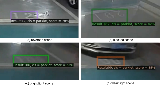
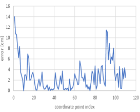
Apart from the anomaly filtering module, the wrong text recognition results (Fig.8) will be further filtered out by their physical positions to improve the localization stability of the system. More specifically, the absolute 3D position of recognition text can be obtained by matching it with the HD semantic map. Subsequently, the test result will be removed if the distance between its physical position and the average position of texts in several previous frames exceeds the threshold. As shown in Fig.9, the localization errors are mostly less than 12cm along the x-axis and less than 15cm along the y-axis, which proves the localization accuracy of this system.
5.4.3 Comparison with other positioning systems
| Methods | Accuracy (I) | Latency (I) | Accuracy (O) | Latency (O) |
|---|---|---|---|---|
| GPS | 20m | immeasurable | 10m | 10ms |
| RTK | 20m | immeasurable | 0.05m | 10ms |
| Ours | 0.3m | 20ms | 0.3m | 20ms |
To fairly compare with other positioning systems, we follow the evaluation metrics proposed by bib24 that the metrics of a positioning system are composed as follows:
-
•
Availability: The positioning technology can be used at the user’s end and does not require special hardware.
-
•
Cost: The positioning system should reduce the cost of incurring additional infrastructure.
-
•
Energy Efficiency: The positioning system must not consume too much energy, such as the batteries of the user-side devices.
-
•
Reception Range: The positioning system can work in large spaces.
-
•
Accuracy: The ideal positioning system should be able to limit the positioning error to less than 10cmbib24 .
-
•
Latency: The positioning system should report the position without significant delay, which requires that the positioning system must not use too much reference information.
-
•
The positioning system should be able to locate multiple objects simultaneously or provide services to a large number of users in a large space at the same time.
| System | Type | Availability | Cost | Energy Efficiency | Reception Range | Accuracy | Latency | Scalability |
| Hours | W | × | ||||||
| Redpin | W | × | × | |||||
| BAT | U | × | × | × | ||||
| Cricket | U | × | × | × | ||||
| Guoguo | AS | × | × | × | × | |||
| WalkieLokie | AS | × | × | × | × | |||
| iBeacon based system in | B | × | × | × | × | |||
| RF-Compass | RFID | × | ||||||
| PinIt | RFID | × | × | × | ||||
| LocaLight | VL | × | × | × | ||||
| Ours | VL | × | × |
Regarding the metrics, the result is shown in Table 7. Our system outperforms others with a good trade-off between the performance phase(reception range, accuracy, latency, and scalability.) and the cost phase(availability, cost, and energy efficiency). Regarding its performance, since it does not require any additional device remotely, it works anywhere(wide reception range) with high accuracy and low latency and can easily deploy to other vehicles(scalability) as long as the system is under the parking scene. Although our system requires the autonomous hardware to be installed, which will fail the cost and availability(ready for any users), the autonomous system will be widely deployed in the future and reduce the financial&using-cost subsequently.
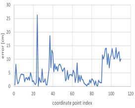
We also compare the positioning accuracy under both isolated and open scenes using GPS and RTK with our method in Table 6. For the isolated scene, due to the weak signal from the underground parking lot, the precision of both GPS and RTK is greater than 20 meters while Fig. 9 shows the accuracy of our system that the average offset of both horizontal(x) and vertical(y) axis of ego vehicle are within 10cm, and the overall positioning offset is less than 0.3 meters. For the open area, The GPS’s precision keeps a great positioning offset of 10 meters while RTK and our method have a precision of 0.05 meters and 0.3 meters respectively.
5.4.4 Comparison experiments with different isolated conditions
To further prove the superiority of our positioning system in the isolated environment, we list some of the performance of some complicated conditions and compare our positioning system under these conditions. It can be seen from Table 8 that our positioning system can also show superior positioning capabilities under complex conditions, with less than 5cm positioning errors.
| Bright light | Weak light | Fuzzy | 45-degrees rotation | 90-degrees rotation | 180-degrees rotation |
| 5cm | 5cm | 4cm | 3cm | 3cm | 3cm |
6 Discussion
In this article, we proposed an OCR-based positioning system aimed at the isolated environment. it can help the ego car to localize itself and gives a much more accurate position than others positioning systems while the wireless signal is invalid. However, the shortages of this system are also significant in that it only works when The following conditions are satisfied:
-
•
The map of the parks is established.
-
•
there are parking numbers available in the parking lots.
Both constraints limit the usage of this system. Regarding the constraints, future explorations can be making OCR satisfy other scenarios such as high speeding way, this system could detect and recognize the signs on the road and localize itself roughly by combing the recognition and map information.
7 Conclusions
In this paper, we propose an integrated real-time vehicle localization system by detecting and recognizing the parking number. Specifically, we employ the text recognition module to localization and classification the parking number. In addition, we utilize a video-stream-based anomaly filtering module to filter incorrect recognition. Furthermore, we propose a localization projection module to transform the detection result to a related location. Extensive results show that the proposed solution can improve the performance on accuracy and stability simultaneously. In particular, our solution achieves state-of-the-art performance on the Parking OCR Dataset.
Declarations
No potential conflict of interest was reported by the authors.
References
- (1) Michele Magno, Stefan Rickli, Josefine Quack, Oliver Bru-necker, and Luca Benini, “Combining lora and rtk to achieve ahigh precision self-sustaining geo-localization system,” in17thACM/IEEE International Conference on Information Process-ing in Sensor Networks (IPSN), 2018, pp. 160–161.
- (2) He X, Pan S, Gao W, et al. LiDAR-Inertial-GNSS Fusion Positioning System in Urban Environment: Local Accurate Registration and Global Drift-Free[J]. Remote Sensing, 2022, 14(9): 2104.
- (3) Liu J, Guo G. Vehicle localization during GPS outages with extended Kalman filter and deep learning[J]. IEEE Transactions on Instrumentation and Measurement, 2021, 70: 1-10.
- (4) El-Mowafy A, Kubo N. Integrity monitoring of vehicle positioning in urban environment using RTK-GNSS, IMU and speedometer[J]. Measurement Science and Technology, 2017, 28(5): 055102.
- (5) Nguyen Dinh-Van, Fawzi Nashashibi, Nguyen Thanh-Huong,and Eric Castelli, “Indoor intelligent vehicle localization usingwifi received signal strength indicator,” in2017 IEEE MTT-SInternational Conference on Microwaves for Intelligent Mobil-ity (ICMIM). IEEE, 2017, pp. 33–36.
- (6) Ruihui Zhu, Yunjia Wang, Hongji Cao, Baoguo Yu, XingliGan, Lu Huang, Heng Zhang, Shuang Li, Haonan Jia, and Jian-Qiang Chen, “Rtk/pseudolite/lahde/imu-pdr integrated pedes-trian navigation system for urban and indoor environments,”Sensors, vol. 20, pp. 1791, 03 2020.
- (7) Yang Y, Xia C, Deng X, et al. HeLPS: Heterogeneous LiDAR-based positioning system for autonomous vehicle[C]//IECON 2020 The 46th Annual Conference of the IEEE Industrial Electronics Society. IEEE, 2020: 618-625.
- (8) Balazs Nagy and Csaba Benedek,“Real-time point cloudalignment for vehicle localization in a high resolution 3d map,”inProceedings of the European Conference on Computer Vi-sion (ECCV) Workshops, September 2018.
- (9) Jiang W, Yu Y, Zong K, et al. A Seamless Train Positioning System Using a Lidar-Aided Hybrid Integration Methodology[J]. IEEE Transactions on Vehicular Technology, 2021, 70(7): 6371-6384.
- (10) Saeed M, Gufran Khan M, Zulfiqar A, et al. Development of ANPR Framework for Pakistani Vehicle Number Plates Using Object Detection and OCR[J]. Complexity, 2021, 2021.
- (11) Kalpana A V, Kavitharani K, Nandhini M. OCR-Based Automatic Toll Collection and Theft Vehicle Detection Using IoT[M]//Next Generation of Internet of Things. Springer, Singapore, 2021: 185-197.
- (12) Shashidhar R, Manjunath A S, Kumar R S, et al. Vehicle Number Plate Detection and Recognition using YOLO-V3 and OCR Method[C]//2021 IEEE International Conference on Mobile Networks and Wireless Communications (ICMNWC). IEEE, 2021: 1-5.
- (13) Yuliang Liu, Hao Chen, Chunhua Shen, Tong He, Lianwen Jin,and Liangwei Wang, “Abcnet: Real-time scene text spottingwith adaptive bezier-curve network,” inProceedings of theIEEE Conference on Computer Vision and Pattern Recognition(CVPR), 2020, pp. 9809–9818.
- (14) Linjie Xing, Zhi Tian, Weilin Huang, and Matthew R Scott,“Convolutional character networks,”inProceedings of theIEEE International Conference on Computer Vision (ICCV),2019, pp. 9126–9136.
- (15) Chengquan Zhang, Borong Liang, Zuming Huang, Mengyi En,Junyu Han, Errui Ding, and Xinghao Ding, “Look more thanonce: An accurate detector for text of arbitrary shapes,” inProceedings of the IEEE Conference on Computer Vision andPattern Recognition (CVPR), 2019, pp. 10552–10561.
- (16) Li B, He M, Wu W, et al. Computation offloading algorithm for arbitrarily divisible applications in mobile edge computing environments: An OCR case[J]. Sustainability, 2018, 10(5): 1611.
- (17) Zhong D, Lyu S, Shivakumara P, et al. Text proposals with location-awareness-attention network for arbitrarily shaped scene text detection and recognition[J]. Expert Systems with Applications, 2022: 117564.
- (18) Kaiming He, Xiangyu Zhang, Shaoqing Ren, and Jian Sun,“Deep residual learning for image recognition,” inProceed-ings of the IEEE Conference on Computer Vision and PatternRecognition (CVPR), 2016, pp. 770–778.
- (19) Tsung-Yi Lin, Piotr Dollar, Ross Girshick, Kaiming He,Bharath Hariharan, and Serge Belongie, “Feature pyramid net-works for object detection,” inProceedings of the IEEE Con-ference on Computer Vision and Pattern Recognition (CVPR),2017, pp. 2117–2125.
- (20) David F Williamson, Robert A Parker, and Juliette S Kendrick,“The box plot: a simple visual method to interpret data,”An-nals of Internal Medicine, vol. 110, no. 11, pp. 916–921, 1989.
- (21) Nastaran Radmehr, Mehran Mehrandezh, and Christine Chan,“Homography-based vehicle pose estimation from a single im-age by using machine-learning for wheel-region and tire-roadcontact point detection,” inInternational Conference on SmartMultimedia. Springer, 2019, pp. 169–179.
- (22) D Bell, W Xiao, and P James, “Accurate vehicle speed estima-tion from monocular camera footage,”ISPRS Annals of Pho-togrammetry, Remote Sensing and Spatial Information Sciences,vol. 5, no. 2, 2020.
- (23) Tushar Jadhav, Kulbir Singh, and Aditya Abhyankar, “Volu-metric 3d reconstruction of real objects using voxel mappingapproach in a multiple-camera environment,”Turkish Journalof Electrical Engineering and Computer Sciences, vol. 26, no. 2,pp. 755–767, 2018.
- (24) Faheem Zafari, Athanasios Gkelias, and Kin K Leung, “A sur-vey of indoor localization systems and technologies,”IEEECommunications Surveys and Tutorials, vol. 21, no. 3, pp. 2568–2599, 2019.
- (25) Tian Z, Huang W, He T, et al. Detecting text in natural image with connectionist text proposal network[C]//European conference on computer vision. Springer, Cham, 2016: 56-72.
- (26) Ziegler J, Bender P, Schreiber M, et al. Making bertha drive—an autonomous journey on a historic route[J]. IEEE Intelligent transportation systems magazine, 2014, 6(2): 8-20.
- (27) Posso-Bautista B, Bacca-Cortés E B, Caicedo-Bravo E. Autonomous vehicle localization method based on an extended Kalman filter and geo-referenced landmarks[J]. Revista de Investigación, Desarrollo e Innovación, 2022, 12(1): 549-564.
- (28) Shi B, Bai X, Belongie S. Detecting oriented text in natural images by linking segments[C]//Proceedings of the IEEE conference on computer vision and pattern recognition. 2017: 2550-2558.
- (29) Zhou X, Yao C, Wen H, et al. East: an efficient and accurate scene text detector[C]//Proceedings of the IEEE conference on Computer Vision and Pattern Recognition. 2017: 5551-5560.
- (30) Wang W, Xie E, Li X, et al. Shape robust text detection with progressive scale expansion network[C]//Proceedings of the IEEE/CVF Conference on Computer Vision and Pattern Recognition. 2019: 9336-9345.
- (31) Liao M, Wan Z, Yao C, et al. Real-time scene text detection with differentiable binarization[C]//Proceedings of the AAAI Conference on Artificial Intelligence. 2020, 34(07): 11474-11481.
- (32) Li H, Wang P, Shen C. Towards end-to-end text spotting with convolutional recurrent neural networks[C]//Proceedings of the IEEE international conference on computer vision. 2017: 5238-5246.
- (33) Liu X, Liang D, Yan S, et al. Fots: Fast oriented text spotting with a unified network[C]//Proceedings of the IEEE conference on computer vision and pattern recognition. 2018: 5676-5685.
- (34) Xing L, Tian Z, Huang W, et al. Convolutional character networks[C]//Proceedings of the IEEE/CVF International Conference on Computer Vision. 2019: 9126-9136.
- (35) Ssekidde P, Steven Eyobu O, Han D S, et al. Augmented CWT features for deep learning-based indoor localization using WiFi RSSI data[J]. Applied Sciences, 2021, 11(4): 1806.
- (36) Yang R, Yang X, Wang J, et al. Decimeter Level Indoor Localization Using WiFi Channel State Information[J]. IEEE Sensors Journal, 2021.
- (37) Bahl P, Padmanabhan V N. RADAR: An in-building RF-based user location and tracking system[C]//Proceedings IEEE INFOCOM 2000. Conference on computer communications. Nineteenth annual joint conference of the IEEE computer and communications societies (Cat. No. 00CH37064). Ieee, 2000, 2: 775-784.
- (38) Polak L, Rozum S, Slanina M, et al. Received Signal Strength Fingerprinting-Based Indoor Location Estimation Employing Machine Learning[J]. Sensors, 2021, 21(13): 4605.
- (39) Retscher G, Leb A. Development of a smartphone-based university library navigation and information service employing Wi-Fi location fingerprinting[J]. Sensors, 2021, 21(2): 432.
- (40) Lin Y, Dong W, Gao Y, et al. Sateloc: A virtual fingerprinting approach to outdoor lora localization using satellite images[J]. ACM Transactions on Sensor Networks (TOSN), 2021, 17(4): 1-28.
- (41) Liu R, Wang J, Zhang B. High definition map for automated driving: Overview and analysis[J]. The Journal of Navigation, 2020, 73(2): 324-341.
- (42) Poggenhans F, Pauls J H, Janosovits J, et al. Lanelet2: A high-definition map framework for the future of automated driving[C]//2018 21st International Conference on Intelligent Transportation Systems (ITSC). IEEE, 2018: 1672-1679.
- (43) Ghallabi F, Mittet M A, Ghayath E L H A J S, et al. LIDAR-based high reflective landmarks (HRL) s for vehicle localization in an HD map[C]//2019 IEEE Intelligent Transportation Systems Conference (ITSC). IEEE, 2019: 4412-4418.
- (44) Hirabayashi M, Sujiwo A, Monrroy A, et al. Traffic light recognition using high-definition map features[J]. Robotics and Autonomous Systems, 2019, 111: 62-72.
- (45) Kim C, Cho S, Sunwoo M, et al. Crowd-sourced mapping of new feature layer for high-definition map[J]. Sensors, 2018, 18(12): 4172.
- (46) Herrtwich R. The evolution of the HERE HD Live Map at Daimler. HERE Technologies[J]. 2019.
- (47) Qin F, Zuo T, Wang X. Ccpos: Wifi fingerprint indoor positioning system based on cdae-cnn[J]. Sensors, 2021, 21(4): 1114.
- (48) Zhu Y, Luo X, Guan S, et al. Indoor positioning method based on WiFi/Bluetooth and PDR fusion positioning[C]//2021 13th International Conference on Advanced Computational Intelligence (ICACI). IEEE, 2021: 233-238.
- (49) Han K, Yu S M, Kim S L, et al. Exploiting user mobility for WiFi RTT positioning: A geometric approach[J]. IEEE Internet of Things Journal, 2021, 8(19): 14589-14606.
- (50) Liu F, Liu J, Yin Y, et al. Survey on WiFi‐based indoor positioning techniques[J]. IET communications, 2020, 14(9): 1372-1383.
- (51) Chen P, Liu F, Gao S, et al. Smartphone-based indoor fingerprinting localization using channel state information[J]. IEEE Access, 2019, 7: 180609-180619.
- (52) Li W, Chen Y, Asif M. A Wi-Fi-based indoor positioning algorithm with mitigating the influence of NLOS[C]//2016 8th IEEE International Conference on Communication Software and Networks (ICCSN). IEEE, 2016: 520-523.
- (53) Chen X, Song S, Xing J. A ToA/IMU indoor positioning system by extended Kalman filter, particle filter and MAP algorithms[C]//2016 IEEE 27th Annual International Symposium on Personal, Indoor, and Mobile Radio Communications (PIMRC). IEEE, 2016: 1-7.
- (54) Nawaz H, Bozkurt A, Tekin I. A novel power efficient asynchronous time difference of arrival indoor localization system using CC1101 radio transceivers[J]. Microwave and Optical Technology Letters, 2017, 59(3): 550-555.
- (55) Alkandari M, Basu D, Hasan S F. A Wi-Fi based passive technique for speed estimation in indoor environments[C]//2017 2nd Workshop on Recent Trends in Telecommunications Research (RTTR). IEEE, 2017: 1-3.
- (56) Oguntala G, Obeidat H, Al Khambashi M, et al. Design framework for unobtrusive patient location recognition using passive RFID and particle filtering[C]//2017 Internet Technologies and Applications (ITA). IEEE, 2017: 212-217.
- (57) Wang X, Wang X, Mao S. CiFi: Deep convolutional neural networks for indoor localization with 5 GHz Wi-Fi[C]//2017 IEEE International Conference on Communications (ICC). IEEE, 2017: 1-6.
- (58) D.Karatzas, F. Shafait, S. Uchida, et al. ICDAR 2013 Robust Reading Competition. In Proc. IAPR Int. Conf. Document Analysis Recog., pages 1484–1493, 2013.
- (59) D. Karatzas, L. Gomez-Bigorda, et al. ICDAR 2015 competition on robust reading. In Proc. IAPR Int. Conf. Document Analysis Recog., pages 1156–1160, 2015.
- (60) Chee-KhengChng, Yuliang Liu, Yipeng Sun, Chun Chet Ng, Canjie Luo, Zihan Ni, ChuanMing Fang, Shuaitao Zhang, Junyu Han, Errui Ding, et al. ICDAR2019 Robust Reading Challenge on Arbitrary-Shaped Text (RRC-ArT). Proc. IAPR Int. Conf. Document Analysis Recog., 2019.
- (61) Nibal Nayef, Yash Patel, Michal Busta, Pinaki Nath Chowdhury, Dimosthenis Karatzas, Wafa Khlif, Jiri Matas, Umapada Pal, Jean-Christophe Burie, Cheng-lin Liu, et al. ICDAR2019 Robust Reading Challenge on Multi-lingual Scene Text Detection and Recognition–RRC-MLT-2019. Proc. IAPR Int. Conf. Document Analysis Recog., 2019.
- (62) Andreas Veit, Tomas Matera, Lukas Neumann, Jiri Matas, and Serge Belongie. Coco-text: Dataset and benchmark for text detection and recognition in natural images. arXiv: Comp. Res. Repository, 2016.
- (63) Minghui Liao, Baoguang Shi, Xiang Bai, Xinggang Wang, and Wenyu Liu. Textboxes: A fast text detector with a single deep neural network. In Proc. AAAI Conf. Artificial Intell., 2017.
- (64) Pengyuan Lyu, Minghui Liao, Cong Yao, Wenhao Wu, and Xiang Bai. Mask textspotter: An end-to-end trainable neural network for spotting text with arbitrary shapes. In Proc. Eur. Conf. Comp. Vis., pages 67–83, 2018.
- (65) Yipeng Sun, Chengquan Zhang, Zuming Huang, Jiaming Liu, Junyu Han, and Errui Ding. TextNet: Irregular Text Reading from Images with an End-to-End Trainable Network. In Proc. Asian Conf. Comp. Vis., pages 83–99. Springer, 2018.
- (66) Hui Li, Peng Wang, and Chunhua Shen. Towards end-to-end text spotting in natural scenes. arXiv: Comp. Res. Repository, 2019.
- (67) Boukthir K, Qahtani A M, Almutiry O, et al. Reduced annotation based on deep active learning for arabic text detection in natural scene images[J]. Pattern Recognition Letters, 2022, 157: 42-48.
- (68) Siyang Qin, Alessandro Bissacco, Michalis Raptis, Yasuhisa Fujii, and Ying Xiao. Towards unconstrained end-to-end text spotting. Proc. IEEE Int. Conf. Comp. Vis., 2019.
- (69) Xing Linjie, Tian Zhi, Huang Weilin, and R. Scott Matthew. Convolutional Character Networks. In Proc. IEEE Int. Conf. Comp. Vis., 2019.
- (70) Qin S, Chen L. Arbitrary-shaped scene text detection with keypoint-based shape representation[J]. International Journal on Document Analysis and Recognition (IJDAR), 2022, 25(2): 115-127.
- (71) Xia C, Shen Y, Yang Y, et al. Onboard Sensors-Based Self-Localization for Autonomous Vehicle With Hierarchical Map[J]. IEEE Transactions on Cybernetics, 2022.
- (72) Ramasamy P, Kabadi M. An autonomous navigational system using GPS and computer vision for futuristic road traffic[J]. International Journal of Electrical and Computer Engineering (2088-8708), 2022, 12(1).
- (73) Wang W, Xie E, Li X, et al. Pan++: Towards efficient and accurate end-to-end spotting of arbitrarily-shaped text[J]. IEEE Transactions on Pattern Analysis and Machine Intelligence, 2021, 44(9): 5349-5367.
- (74) Zhu Y, Chen J, Liang L, et al. Fourier contour embedding for arbitrary-shaped text detection[C]//Proceedings of the IEEE/CVF conference on computer vision and pattern recognition. 2021: 3123-3131.