Vision-based GNSS-Free Localization for
UAVs in the Wild
Abstract
Considering the accelerated development of Unmanned Aerial Vehicles (UAVs) applications in both industrial and research scenarios, there is an increasing need for localizing these aerial systems in non-urban environments, using GNSS-Free, vision-based methods. Our paper proposes a vision-based localization algorithm that utilizes deep features to compute geographical coordinates of a UAV flying in the wild. The method is based on matching salient features of RGB photographs captured by the drone camera and sections of a pre-built map consisting of georeferenced open-source satellite images. Experimental results prove that vision-based localization has comparable accuracy with traditional GNSS-based methods, which serve as ground truth. Compared to state-of-the-art Visual Odometry (VO) approaches, our solution is designed for long-distance, high-altitude UAV flights. Code and datasets are available at https://github.com/TIERS/wildnav.
Index Terms:
UAV; MAV; GNSS-Free; GNSS-denied; Vision-based localization; Photogrammetry; Computer vision; Perception-based localization; Visual OdometryI Introduction
Unmanned Aerial Vehicles (UAVs) are currently used in a wide range of scenarios and commercial applications. They already have reliable localization methods based on the Global Navigation Satellite System (GNSS) [1], Visual-Inertial Simultaneous Localization and Mapping (VI-SLAM) [2], or Ultra-wideband (UWB) systems [3]. The first method is usually used in outdoor environments, where it is relatively simple to use a GNSS sensor to obtain accurate positioning data [4]. The second and third methods prove their utility in environments where GNSS signal is unreliable, for example inside buildings, where localization systems such as UWB [5, 6] or VI-SLAM are preferred [7]. ††——————————————————————————————This research work is supported by the Academy of Finland’s AutoSOS and AeroPolis projects (Grant No. 328755 and 348480) and by the Finnish Ministry of Defence’s Scientific Advisory Board for Defence (MATINE) project WildNav.
Autonomy of aerial drones and their hardware capability have significantly improved in the last years [8], enabling them to safely fly autonomously over relatively long distances, beyond visual line of sight (BVLOS). However, less attention had been given to providing accurate positioning data during long distance UAV flights without using GNSS, which would lead to more resilient solutions. This is an essential matter since UAVs are mission-critical systems in need of a failsafe mechanism that can be automatically engaged when GNSS signal becomes unavailable due to various reasons, such as jamming or spoofing [9].
At the same time, image processing capabilities using deep neural networks have been constantly improving in the last decade, enabling even real-time recognition of objects and segmentation. This observation also holds for the processing of satellite image data, where artificial intelligence (AI) models are trained to differentiate between important objects such as buildings and rivers [10].
Building on top of available open source technology and algorithms [11, 12], this paper aims to provide a reliable positioning mechanism for UAVs by only using RGB photographs provided by a camera mounted on the drone and open-source satellite images of the flight area. The method is based on deep neural image segmentation that enables the localization of the UAV by extracting recognizable features of buildings, roads, rivers and forest edges. These features are further matched to static satellite images using a robust method based on a graph neural network model [11].
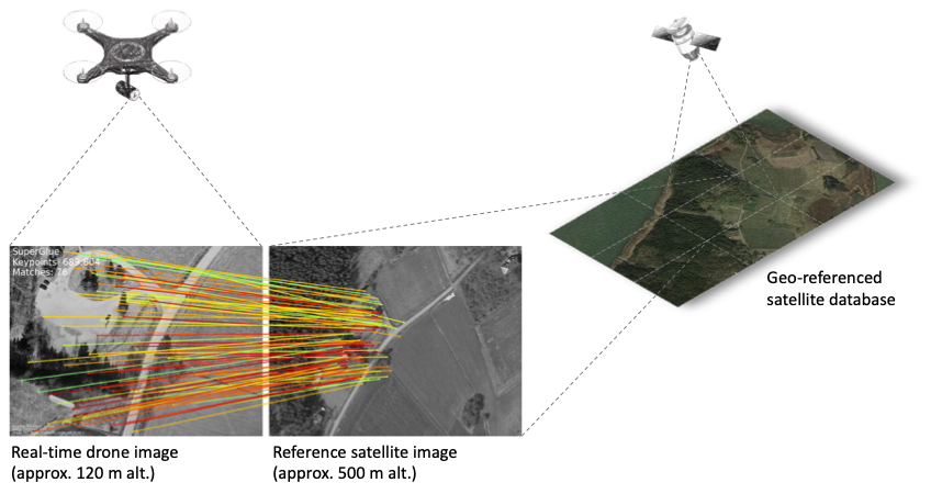
Fig. 1 shows the core idea of the proposed visual-based localization method, where an UAV flying at a high altitude – provided that the ground surface below it has enough landmarks with salient features – is able to match the camera stream with onboard, georeferenced, open-source satellite images.
The paper is organized in 6 sections as follows. Section II provides a brief overview of related works on which the current paper is based. Section III explains the motivation and applicability of the implemented vision-based algorithm, while Section IV presents the approach used for determining the absolute geographical coordinates of a UAV. Section V discusses the experimental localization results. Finally, Section VI concludes the work and outlines future research directions.
II Background
Previous studies directly related to our paper include semantic segmentation based path planning [13], localization using open source Google Earth (GE) aerial images [14] and pose estimation with neural networks trained with georeferenced satellite photographs [15]. In addition to these, an open source image segmentation model originally used for building virtual worlds [16] can prove its utility in providing useful input both for localization and navigation purposes, as proposed in [13].
Additionally, a graph neural network that provides feature computation and matching for outdoor images, SuperGlue [11], became part of the implementation in our proposed localization algorithm due to its remarkable performance of matching features in photographs which significantly differ in perspective and lighting conditions. The model proved its efficient application not only for matching features, but also for the perspective transformations (namely homography) used in computing geographical coordinates when running the implemented vision-based localization algorithm. Before selecting Superglue as a feature matcher between drone camera photographs and satellite images, template matching [17] and SIFT features [18] were also taken into consideration. The latter two options were dropped due to their relatively high computation time and inaccuracy, compared to [11].
Another remarkable paper is [12], which uses an advanced template-based matching algorithm to compute the pose estimation of a UAV using only images. Because of insufficient computation resources at the time, no implementation is provided on the onboard computer of a drone. Another major difference, compared to our approach, is that the drone navigates specifically urban environments, where computing and matching visual features is much less of a challenge, compared to natural, in the wild, flying areas.
Currently, the state-of-the-art of navigation approaches in a priori unknown environments are Simultaneous Localization and Mapping (SLAM) algorithms, which have arguably reached a high-degree of robustness and reliability in the past decade [19]. An important building block of SLAM algorithms are VO methods [20], which allow UAVs to accurately determine their position while navigating new environments. However, one major limiting factor of these approaches is that they make the assumption the UAV is flying at a low enough altitude that an RGB monocular or stereo camera can easily track position shifts in detected features from frame to frame. Our work focuses on high-altitude flight (120 meters), a situation where a different approach for localization is needed, as presented in Section III.
III Providing GNSS-Free vision-based localization
Our main goal is developing a localization algorithm that does not rely on GNSS for long-distance flights, but only on a monocular wide-angle camera. This kind of approach proves its utility in situations where GNSS signal cannot be reliably used and as a failsafe alternative that enables the drone to reach its goal position or at least land safely in a pre-established location. New commercial implementations such as autonomous drone delivery could use the new localization method to improve the reliability of navigation.
The core attribute of the project is the environment in which vision-based localization is provided: in the wild, denoting natural (non-urban) environments where artificial structures such as buildings and roads are sparse. This characteristic transforms what would be a trivial feature matching and homography computation problem inside a city into a challenging process, due to the difficulty of finding salient features in natural environments. Nevertheless, the final implementation is able to provide accurate localization results using a neural network for feature matching between drone photographs and satellite images.
Another significant feature of the implemented localization algorithm is that the pre-mapping process does not require the UAV to fly. The map is built using exclusively open-source satellite images, with the objective of enabling autonomous localization in any area where the drone can fly, assuming it is legally and physically possible (due to harsh environmental conditions).
IV Methodology
Accurate feature matching of images is only useful if the drone camera photographs can be precisely linked to geographical coordinates. An important assumption of our proposed localization method is that the flight area of the UAV is known a priori, so a map for that specific zone can be built and uploaded to the onboard computer for offline use. The map is composed of rectangular sections representing RGB satellite images with an approximate resolution of 1400×1200 pixels, collected from GE. Each one of these sections are collected from the same perspective, with the camera view perpendicular to the ground surface and from an altitude that offers a similar field of view to a wide angle camera. One example of these sections can be observed in Fig. 2, where the transparent white rectangle represents the georeferenced map tile. There is a linear relation (see Equations 1 and 2) between the pixel coordinates of the image file and absolute geographical coordinates.

IV-A Georeferencing map sections
Because the flight area is generally too large to be represented as only one image file, the map is split into different section, each one of them with two distinct geographical coordinates, a (latitude, longitude) pair for the top left corner and another one for the right bottom corner. Instead of using a unique pair of coordinates that correspond to the center of the image, it is more accurate to geographically reference two corners of the section. In this manner, any set of features located in the image can be accurately linked to geographical coordinates with a simple equation that relates pixels to latitude:
| (1) |
where
ll
&= computed latitude
= top left corner latitude
= vertical pixel coordinate of matched features
= height of the satellite image in pixels
= right bottom corner latitude
Using the same logic, longitude is computed as follows:
| (2) |
where
ll
&= computed longitude
= top left corner longitude
= horizontal pixel coordinate of matched features
= width of the satellite image in pixels
= right bottom corner longitude
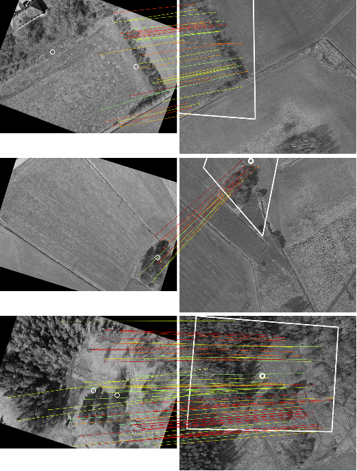
Since any set of matched features can be enclosed in a polygon in the georeferenced satellite image, the center of that polygon – represented by the and pixel coordinates – can be used to directly compute the geographical coordinates. In other words, the coordinate system is changed from pixels in a local image file to latitude and longitude. This approach enables the algorithm to pinpoint accurately the geographical coordinates of an image region rich in salient features (e.g., a special shape such as the road in Fig. 3). Fig. 4 shows examples of successfully matched drone-satellite image pairs, in spite of the relative scarcity of available features in the natural environment. Algorithm 1 presents the detailed sequence of computations needed for computing the geographical position of the UAV.
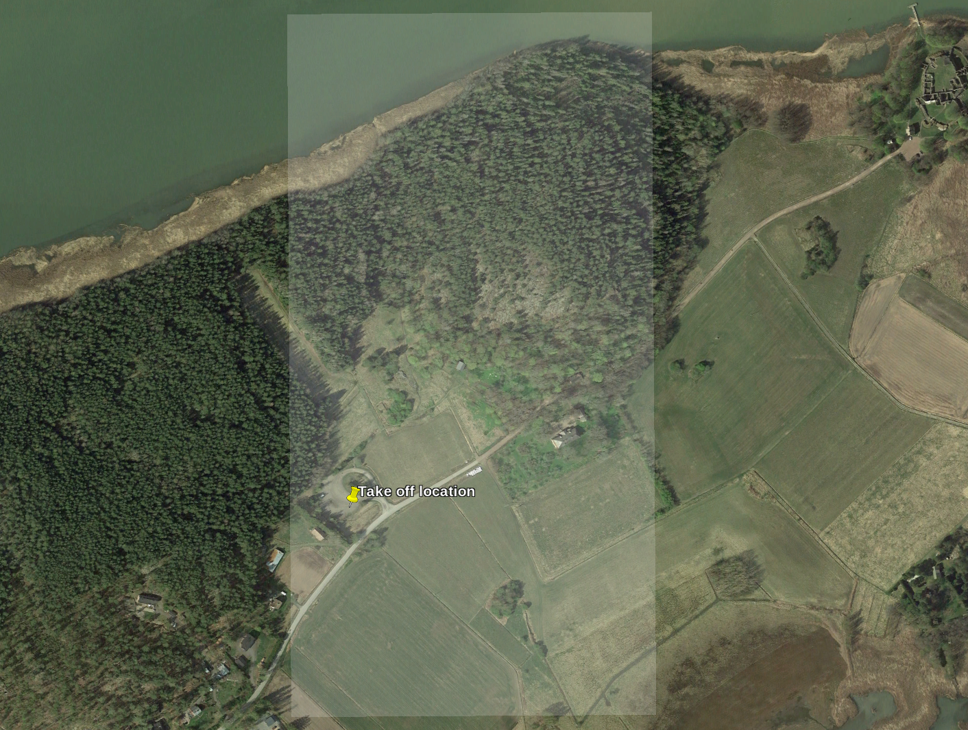
Fig. 3 provides a bird’s-eye view of the flight area chosen for gathering the drone photographs used for testing the developed algorithms. The zone was selected for a number of reasons, in particular because it contains a multitude of different surfaces (forests, fields, roads, sea shores, buildings) in a relatively small perimeter. In addition, it is also a sparsely populated area, which makes it suitable for drone experiments in accordance with EU regulation on the utilization of UAVs.
IV-B Computing geographical coordinates
Algorithm 1 provides the core functionality of this project’s software implementation. The developed method accepts as input RGB photographs (either JPEG or PNG) taken by the downward-facing drone camera and matches them against a pre-built map consisting of satellite georeferenced images (the map can be varying in size, depending on the size of the flying zone). Upon successful localization of a drone captured photograph, the output is a pair of absolute geographical coordinates (latitude and longitude), indicating the position of the aerial vehicle.
In order to compute geographical coordinates, the algorithm uses a fairly simple approach. It starts by rotating the drone photograph using the image metadata providing the orientation of the UAV and the camera gimbal to match the heading of the map sections (always oriented northwards). The rotation is necessary because it improves the number of features which can be matched for a pair of images. Secondly, the features of both images (drone and satellite) are computed and matched against each other. This process is repeated for all the satellite images and the drone is assumed to be located in the map section which has the most matches with the current camera photograph. Following the feature matching process, a perspective transformation is computed, that provides a link between the position of the matched features in the georeferenced map image and their location in the drone photograph. Since the matched map section is a rectangle with a priori known geographical coordinates, it is possible to convert from pixel coordinates to latitude and longitude in a straightforward manner (see Equations 1 and 2 for the detailed calculation method).
An important parameter of the algorithm is the method used for differentiating between the matched features which represent inliers and the ones which are outliers. The method is called random sample consensus (RANSAC) and it improves accuracy of the localization algorithm by selecting only features which are relatively close together. These valid features are further used for the computation of the perspective transform and outliers are discarded. The minimum number of matched features between a pair of photographs that enable the computation of the drone position is four, otherwise the perspective transform cannot be calculated. If the drone flies over featureless surfaces such as fields or forests, an incorrect section of the map could be matched with the camera photograph, resulting in erroneous geographical coordinates.
V Experimental Results
This section presents the experimental results for a photograph dataset on which the localization algorithm was tested. The photographs were taken on sunny weather in the wild (non-urban environment), from an altitude of approximately 120 meters AGL. Each photograph was captured from the same perspective (camera facing the ground surface). The camera used for gathering the dataset was a H20T, with a 12 Megapixel RGB sensor that has a 82.9∘ field of view and 4.5 mm focal length. The utilized UAV was a DJI Matrice 300, manually controlled by a human pilot inside the perimeter shown in Fig. 3 The ground truth is provided by the GNSS metadata embedded into each photograph.
(a) Query image (b) Database image
The overall performance of the vision-based localization algorithm can be summarized by Fig. 6. The error is calculated by considering the proximity of the computed geographical coordinates to the ground truth, represented by the GNSS metadata for each photograph. A comparison between the absolute GNSS coordinates (ground truth) and the coordinates provided by our proposed localization algorithm can be seen in Fig. 5. The dataset consists of 126 photographs in total, from which 77 were successfully located using our vision-based algorithms. A photograph was considered successfully localized if the error between the ground truth GNSS position of the drone and the location computed by the vision-based algorithm was less than 50 meters. For the whole dataset, a mean average error (MAE) of 15.82 meters suggests the new localization method has an accuracy that can be compared to that of standard GNSS positioning methods, for which the error can range from 1 to 20 meters under clear sky conditions [21], depending on other factors such as the available number of satellites. The coordinates determined by the vision-based localization algorithm closely follow the GNSS ones, with a few exceptions where the error exceeds 30 meters, as can be seen in Fig. 6. Admittedly, the accuracy is not high enough to be used in precision maneuvers or at low altitudes where obstacles are present, but the algorithm represents an important building block towards GNSS-Free navigation strategies for UAVs.
Since the feature matching model is not rotation invariant, it was necessary to use the metadata of the drone photographs to align them with the map images, which have the same heading (north). Because the UAV compass suffered from a systematic error, all the recorded photographs were rotated with 15∘ clockwise in addition to the gimbal and drone yaw. This small correction reduced the misalignment between the drone photographs and their satellite counterparts, maximizing the performance of the feature matching algorithm.
The MAE value (15.82 m) is of particular interest because it shows that most of the images for the first experiment are located with an error comparable to traditional GNSS services. The computed geographical coordinates feature significantly increased errors, which suggests that navigation strategies must include mechanisms that allow the UAV to fly only over surfaces that offer salient features to be matched. The performance of the vision-based localization algorithm is directly dependent on the trajectory computed by the path planner, as suggested in [13].
There are a number of important factors which affect the accuracy of the vision-based localization algorithm. Among these are weather and light – depending on the season and the amount of lighting, the drone photographs could have more or less features that can be matched with the onboard satellite map. The photos taken during the experiments were taken one year later, but in the same month (May) as the satellite images, in order to maximize the similarity between them. Moreover, flying above featureless surfaces such as empty fields or water can render the vision-based localization algorithm ineffective since it is based on recognition of salient features.
Another important aspect is that artificial structures such as buildings and roads tend to have more features that can be tracked and matched, compared to natural objects. This is the reason that transforms feature matching into a challenging task when performed in the wild (outside urban environments). In addition to this, the open source photographs for non-urban environments are characterized by lower resolution and are more rarely updated than data available for cities. Nonetheless, Fig. 4 shows that the model developed in this project is able to provide accurate matching results even when the drone photographs differ in perspective, rotation and contain surfaces sparse in salient features.
VI Conclusion
The goal of this paper was to demonstrate that GNSS-Free vision-based localization of UAVs flying in the wild was not only possible, but a viable method which provides accurate results. To achieve this objective, a robust localization algorithm was implemented. To prove its effectiveness, the vision-based localization algorithm was tested on an experimental dataset consisting of RGB photographs taken with a drone flying at high altitude in the wild.
The most important feature to be researched in the future is adding the possibility of using a LIDAR to improve the localization capabilities of the algorithm in different lighting scenarios. This approach would enable localization of the UAV even during night or harsh weather conditions, significantly extending the applicability of the studied GNSS-Free localization algorithm.
Another improvement would be the implementation of a path planner that dictates the trajectory of the UAV, given an initial position and an end goal. The path planner would make use of the developed vision-based localization algorithm and also devise a navigation strategy to avoid flying the drone above featureless areas, where pose estimation using visual techniques becomes challenging or impossible.
An incremental improvement of the current implementation, given enough resources, could be done by retraining the graph neural network used in feature matching using RGB photographs taken with the drone camera in different non-urban environments. Although time-consuming, the retraining process would significantly improve the accuracy of the localization algorithm.
Acknowledgment
This research work is supported by the Academy of Finland’s AutoSOS and AeroPolis projects (Grant No. 328755 and 348480) and by the Finnish Ministry of Defence’s Scientific Advisory Board for Defence (MATINE) project WildNav.
References
- [1] Bilal Hazim Younus Alsalam, Kye Morton, Duncan Campbell, and Felipe Gonzalez. Autonomous uav with vision based on-board decision making for remote sensing and precision agriculture. In 2017 IEEE Aerospace Conference, pages 1–12. IEEE, 2017.
- [2] Tong Qin, Peiliang Li, and Shaojie Shen. Vins-mono: A robust and versatile monocular visual-inertial state estimator. IEEE Transactions on Robotics, 34(4):1004–1020, 2018.
- [3] Yu Xianjia, Li Qingqing, Jorge Peña Queralta, Jukka Heikkonen, and Tomi Westerlund. Cooperative UWB-based localization for outdoors positioning and navigation of UAVs aided by ground robots. In IEEE International Conference on Autonomous Systems (IEEE ICAS 2021). IEEE, 2021.
- [4] Julián Tomastik, Martin Mokroš, Peter Surovy, Alžbeta Grznárová, and Ján Merganič. Uav rtk/ppk method—an optimal solution for mapping inaccessible forested areas? Remote sensing, 11(6):721, 2019.
- [5] Jorge Peña Queralta, Carmen Martínez Almansa, Fabrizio Schiano, Dario Floreano, and Tomi Westerlund. Uwb-based system for uav localization in gnss-denied environments: Characterization and dataset. In 2020 IEEE/RSJ International Conference on Intelligent Robots and Systems (IROS), pages 4521–4528. IEEE, 2020.
- [6] Jorge Peña Queralta, Li Qingqing, Fabrizio Schiano, and Tomi Westerlund. Vio-UWB-based collaborative localization and dense scene reconstruction within heterogeneous multi-robot systems. In IEEE International Conference on Advanced Robotics and Mechatronics. IEEE, 2022.
- [7] Jesus Tordesillas and Jonathan P How. Panther: perception-aware trajectory planner in dynamic environments. arXiv preprint arXiv:2103.06372, 2021.
- [8] Thien-Minh Nguyen, Muqing Cao, Shenghai Yuan, Yang Lyu, Thien Hoang Nguyen, and Lihua Xie. Viral-fusion: A visual-inertial-ranging-lidar sensor fusion approach. IEEE Transactions on Robotics, 38(2):958–977, 2021.
- [9] Mark L. Psiaki and Todd E. Humphreys. Gnss spoofing and detection. Proceedings of the IEEE, 104(6):1258–1270, 2016.
- [10] Jacob Shermeyer, Daniel Hogan, Jason Brown, Adam Van Etten, Nicholas Weir, Fabio Pacifici, Ronny Hansch, Alexei Bastidas, Scott Soenen, Todd Bacastow, et al. Spacenet 6: Multi-sensor all weather mapping dataset. In Proceedings of the IEEE/CVF Conference on Computer Vision and Pattern Recognition Workshops, pages 196–197, 2020.
- [11] Paul-Edouard Sarlin, Daniel DeTone, Tomasz Malisiewicz, and Andrew Rabinovich. Superglue: Learning feature matching with graph neural networks. In Proceedings of the IEEE/CVF conference on computer vision and pattern recognition, pages 4938–4947, 2020.
- [12] Aurelien Yol, Bertrand Delabarre, Amaury Dame, Jean-Emile Dartois, and Eric Marchand. Vision-based absolute localization for unmanned aerial vehicles. In 2014 IEEE/RSJ International Conference on Intelligent Robots and Systems, pages 3429–3434. IEEE, 2014.
- [13] Luca Bartolomei, Lucas Teixeira, and Margarita Chli. Perception-aware path planning for uavs using semantic segmentation. In 2020 IEEE/RSJ International Conference on Intelligent Robots and Systems (IROS), pages 5808–5815. IEEE, 2020.
- [14] Bhavit Patel, Timothy D Barfoot, and Angela P Schoellig. Visual localization with google earth images for robust global pose estimation of uavs. In 2020 IEEE International Conference on Robotics and Automation (ICRA), pages 6491–6497. IEEE, 2020.
- [15] Akshay Shetty and Grace Xingxin Gao. Uav pose estimation using cross-view geolocalization with satellite imagery. In 2019 International Conference on Robotics and Automation (ICRA), pages 1827–1833. IEEE, 2019.
- [16] Eric Guérin, Killian Oechslin, Christian Wolf, and Benoît Martinez. Satellite image semantic segmentation. arXiv preprint arXiv:2110.05812, 2021.
- [17] Kai Briechle and Uwe D Hanebeck. Template matching using fast normalized cross correlation. In Optical Pattern Recognition XII, volume 4387, pages 95–102. SPIE, 2001.
- [18] David G Lowe. Distinctive image features from scale-invariant keypoints. International journal of computer vision, 60(2):91–110, 2004.
- [19] Andréa Macario Barros, Maugan Michel, Yoann Moline, Gwenolé Corre, and Frédérick Carrel. A comprehensive survey of visual slam algorithms. Robotics, 11(1):24, 2022.
- [20] Jeffrey Delmerico and Davide Scaramuzza. A benchmark comparison of monocular visual-inertial odometry algorithms for flying robots. In 2018 IEEE international conference on robotics and automation (ICRA), pages 2502–2509. IEEE, 2018.
- [21] Michael G Wing, Aaron Eklund, and Loren D Kellogg. Consumer-grade global positioning system (gps) accuracy and reliability. Journal of forestry, 103(4):169–173, 2005.