Carrier-phase and IMU based GNSS Spoofing Detection for Ground Vehicles
Carrier-phase and IMU based GNSS Spoofing Detection for Ground Vehicles
Biographies
Zachary Clements (BS, Electrical Engineering, Clemson University) is a graduate student in the department of Aerospace Engineering and Engineering Mechanics at The University of Texas at Austin, and a member of the UT Radionavigation Laboratory. His research interests include GNSS signal processing, spoofing detection techniques, software-defined radio, and sensor fusion.
James Yoder (BS, Electrical Engineering, The University of Texas at Austin) is a graduate student in the department of Aerospace Engineering and Engineering Mechanics at The University of Texas at Austin, and a member of the UT Radionavigation Laboratory. His research interests include GNSS signal processing, estimation, and sensor fusion techniques for centimeter-accurate navigation.
Todd Humphreys (BS, MS, Electrical Engineering, Utah State University; PhD, Aerospace Engineering, Cornell University) is a professor in the department of Aerospace Engineering and Engineering Mechanics at The University of Texas at Austin, where he directs the Radionavigation Laboratory. He specializes in the application of optimal detection and estimation techniques to problems in secure, collaborative, and high-integrity perception, with an emphasis on navigation, collision avoidance, and precise timing. His awards include The University of Texas Regents’ Outstanding Teaching Award (2012), the National Science Foundation CAREER Award (2015), the Institute of Navigation Thurlow Award (2015), the Qualcomm Innovation Fellowship (2017), the Walter Fried Award (2012, 2018), and the Presidential Early Career Award for Scientists and Engineers (PECASE, 2019). He is a Fellow of the Institute of Navigation and of the Royal Institute of Navigation.
Abstract
This paper develops, implements, and validates a powerful single-antenna carrier-phase-based test to detect Global Navigation Satellite Systems (GNSS) spoofing attacks on ground vehicles equipped with a low-cost inertial measurement unit (IMU). Increasingly-automated ground vehicles require precise positioning that is resilient to unusual natural or accidental events and secure against deliberate attack. This paper’s spoofing detection technique capitalizes on the carrier-phase fixed-ambiguity residual cost produced by a well-calibrated carrier-phase-differential GNSS (CDGNSS) estimator that is tightly coupled with a low-cost IMU. The carrier-phase fixed-ambiguity residual cost is sensitive at the sub-centimeter-level to discrepancies between measured carrier phase values and the values predicted by prior measurements and by the dynamics model, which is based on IMU measurements and on vehicle constraints. Such discrepancies will arise in a spoofing attack due to the attacker’s practical inability to predict the centimeter-amplitude vehicle movement caused by roadway irregularities. The effectiveness of the developed spoofing detection method is evaluated with data captured by a vehicle-mounted sensor suite in Austin, Texas. The dataset includes both consumer- and industrial-grade IMU data and a diverse set of multipath environments (open sky, shallow urban, and deep urban). Artificial worst-case spoofing attacks injected into the dataset are detected within two seconds.
Introduction
The combination of easily-accessible low-cost Global Navigation Satellite System (GNSS) spoofers and the emergence of increasingly-automated GNSS-reliant ground vehicles prompts a need for fast and reliable GNSS spoofing detection [1, 2]. To underscore this point, Regulus Cyber recently spoofed a Telsa Model 3 on autopilot mode, causing the vehicle to suddenly slow and unexpectedly veer off the main road [3].
Among GNSS signal authentication techniques, signal-quality-monitoring (SQM) and multi-antenna could be considered for implementation on ground vehicles [4]. However, SQM tends to perform poorly on dynamic platforms in urban areas where strong multipath and in-band noise are common [5, 6, 4, 7], and multi-antenna spoofing detection techniques, while effective [8, 9], are disfavored by automotive manufacturers seeking to reduce vehicle cost and aerodynamic drag. Thus, there is a need for a single-antenna GNSS spoofing detection technique that performs well on ground vehicles despite the adverse signal-propagation conditions in an urban environment.
In a concurrent trend, increasingly-automated ground vehicles demand ever-stricter lateral positioning to ensure safety of operation. An influential recent study calls for lateral positioning better than 20 cm on freeways and better than 10 cm on local streets (both at 95%) [10]. Such stringent requirements can be met by referencing lidar and camera measurements to a local high-definition map [11, 12], but poor weather (heavy rain, dense fog, or snowy whiteout) can render this technique unavailable [13]. On the other hand, recent progress in precise (dm-level) GNSS-based ground vehicle positioning, which is impervious to poor weather, has demonstrated surprisingly high (above 97%) solution availability in urban areas [14]. This technique is based on carrier-phase differential GNSS (CDGNSS) positioning, which exploits GNSS carrier phase measurements having mm-level precision but integer-wavelength ambiguities [15].
Key to the promising results in [14] is the tight coupling of CDGNSS and IMU measurements, without which high-accuracy CDGNSS solution availability is significantly reduced due to pervasive signal blockage and multipath in urban areas (compare the improved performance of [14] relative to [16]). Tight coupling brings mm-precise GNSS carrier phase measurements into correspondence with high-sensitivity and high-frequency inertial sensing. The particular estimation architecture of [14] incorporates inertial sensing via model replacement, in which the estimator’s propagation step relies on bias-compensated acceleration and angular rate measurements from the IMU instead of a vehicle dynamics model. As a consequence, at each measurement update, an a priori antenna position is available whose delta from the previous measurement update accounts for all vehicle motion sensed by the IMU, including small-amplitude high-frequency motion caused by road irregularities. Remarkably, when tracking authentic GNSS signals in a clean (open sky) environment, the GNSS carrier phase predicted by the a priori antenna position and the actual measured carrier phase agree to within millimeters.
This paper pursues a novel GNSS spoofing detection technique based on a simple but consequential observation: it is practically impossible for a spoofer to create a false ensemble of GNSS signals whose carrier phase variations, when received through the antenna of a target ground vehicle, track the phase values predicted by inertial sensing. In other words, antenna motion caused by road irregularities, or rapid braking, steering, etc., is sensed with high fidelity by an onboard IMU but is unpredictable at the sub-cm-level by a would-be spoofer. Therefore, the differences between IMU-predicted and measured carrier phase values offer the basis for an exquisitely sensitive GNSS spoofing detection statistic. What is more, such carrier phase fixed-ambiguity residual cost is generated as a by-product of tightly-coupled inertial-CDGNSS vehicle position estimation such as performed in [14].
Two difficulties complicate the use of fixed-ambiguity residual cost for spoofing detection. First is the integer-ambiguous nature of the carrier phase measurement [15], which causes the post-integer-fix residual cost to equal not the difference between the measured and predicted carrier phase, as would be the case for a typical residual, but rather this difference modulo an integer number of carrier wavelengths. Such integer folding complicates development of a probability distribution for a detection test statistic based on carrier phase fixed-ambiguity residual cost.
Second, the severe signal multipath conditions in urban areas create thick tails in any detection statistic based on carrier phase measurements. Setting a detection threshold high enough to avoid false spoofing alarms caused by mere multipath could render the detection test insensitive to dangerous forms of spoofing. Reducing false alarms by accurately modeling the effect of a particular urban multipath environment on the detection statistic would be a Sisyphean undertaking, requiring exceptionally accurate up-to-date 3D models of the urban landscape, including materials properties.
This paper takes an empirical approach to these difficulties. It does not attempt to develop a theoretical model to delineate the effects of integer folding or multipath on its proposed carrier-phase fixed-ambiguity residual cost based detection statistic. Rather, it develops null-hypothesis empirical distributions for the statistic in both shallow and deep urban areas, and uses these distributions to demonstrate that high-sensitivity spoofing detection is possible despite integer folding and urban multipath.
Related Work
The idea of using coupled GNSS and inertial sensing to detect GNSS spoofing was first explored for aviation [17, 18, 19, 20, 21, 22]. Wind gusts and turbulence cause rapid movement of aircraft that are instantaneously reflected in calibrated inertial measurements. As with road irregularities for ground vehicles, a GNSS spoofer will find it challenging to track and replicate such movements in real-time. However, this prior work either did not exploit carrier-phase measurements or relied on a tactical-grade IMU, rendering solutions either too slow (long time-to-detect) or too expensive.
Accumulating innovation faults within a specified time window in a loosely coupled INS/GNSS Kalman filter was investigated in [23]. For a given time window, there are two ways to accumulate the slowly-drifting faults. One averages the normalized sum-squared innovations of each epoch (innovation averaging); the other averages the measurements within a time window and subsequently performs a snapshot test (measurement averaging). Innovation averaging has little effect on the Kalman filter prediction and filtering process, so it can be easier to deploy and can be designed as an add-on function. Measurement averaging requires small modifications of the Kalman filter measurement update process. The position-domain spoofing detection strategy in [23] required 15 seconds to detect a fairly obvious spoofing attack with position drift of 5 m/s. Such a time to detect is unacceptably long for an automated ground vehicle.
Prior work in spoofing detection specifically for ground vehicles demonstrated that low-cost IMUs could be used to detect GNSS spoofing by constructing a coherency test between the GNSS and inertial measurements [24]. But the test statistic in [24] was constructed from position-domain measurements, and so is much less sensitive than the carrier-phase-based test proposed in the current paper, resulting in an unacceptably-long (3 minute) time to detection.
Contributions
This paper’s primary contributions are (i) the development and verification of a highly sensitive all-environment single-antenna GNSS spoofing detection technique based on carrier-phase fixed-ambiguity residual cost produced by a well-calibrated CDGNSS solution that is tightly coupled with a low-cost IMU, (ii) the introduction of an artificial worst-case spoofing methodology, and (iii) a comparison between industrial- and consumer-grade IMUs for spoofing detection within the proposed framework.
Measurement Model
The full formulation of the measurement model for the tightly-coupled GNSS-IMU estimator on which this paper’s spoofing detection technique is based may be found in [14]. Key developments are presented here for the reader’s convenience.
The estimator ingests pairs of double-difference (DD) GNSS observables at each GNSS measurement epoch, with each pair composed of a pseudorange and a carrier phase measurement. The measurement vector at epoch is
where and are vectors of double-difference pseudorange and carrier phase measurements, both in meters. At epoch , after linearizing about the a priori state estimate, a measurement model can be expressed as
| (1) |
where is the difference between the measurement and its modeled value based on the a priori state estimate, and are Jacobians, is the state estimate error vector, is the the integer ambiguity vector, and is noise. A short-baseline regime is assumed for the DD measurements, which implies that ionospheric, tropospheric, ephemeris, and clock errors are cancelled in the double differencing, leaving to account only for multipath and receiver thermal noise. The prior on the real-valued error state can be expressed in terms of the following data equation:
| (2) |
The CDGNSS measurement update of the tightly-coupled GNSS-IMU estimator can be cast in square-root form for greater numerical robustness and algorithmic clarity [25]. Given , , , and the data equation above, the measurement update can be defined as the process of finding and to minimize the cost function
The vector cost components can be normalized by left multiplying with square-root information matrices based on Cholesky factorization , :
The cost can be decomposed via QR factorization
where matrix is orthogonal and is upper triangular. Because is orthogonal, the components of inside the norm can be left-multiplied by without changing the cost, and can be decomposed into 3 terms:
| (3) | ||||
If both the measurement model and are not ill-conditioned, then and are invertible. can be zeroed for any value of due to the invertibility of . is the irreducible cost, and, under a single-epoch ambiguity resolution scheme, can be shown to be equal to the normalized innovations squared (NIS) associated with the double-difference pseudorange measurements.
is the extra cost incurred by enforcing the integer constraint on . If is allowed to take any real value (the float solution), can be zeroed due to the invertibility of . The float solution is formed by choosing and to zero and . Because is upper triangular, these values can be found by efficient backsubstitution. The fixed solution is found via an integer least squares (ILS) solver, yielding
| (4) | ||||
Note that is the a posteriori state vector square-root information matrix conditioned on .
Test Statistic
Key to this paper’s spoofing detection statistic is the integer-fixed carrier-phase residual cost
which can also be thought of as the ILS solution cost [26]. This is small whenever the carrier phase measurements are consistent with the prior state estimate, the pseudorange measurements, and with the assumption of integer-valued carrier-phase ambiguities. It is one of several acceptance test statistics used to decide whether the fixed solution is correct with high probability [15]. In [27], was incorporated in a statistic used to detect carrier cycle slips. It can similarly be used to detect false integer fixes, just as with other integer aperture acceptance test statistics, or the lingering effects of conditioning the real-valued part of the state on a previous false fix [14].
Furthermore, provides is a highly sensitive statistic for spoofing detection. When no spoofing is present, there is tight agreement between the IMU-propagated a priori state estimate and GNSS data resulting in a small . If the vehicle hits a bump in the road, the GNSS antenna phase center will rise by a few centimeters, and the inertial sensor will detect a corresponding acceleration, which will get propagated through to the a priori state. On the other hand, when spoofing is present, a discrepancy between inertial and GNSS data will arise at the carrier-phase level, leading to being larger than usual.
A windowed sum of offers even greater sensitivity to false fix events at the expense of a longer time to detect. The test statistic used to detect spoofing in this paper is the windowed fixed-ambiguity residual cost (WFARC), . This is calculated over a moving window of fixed length of past GNSS measurement epochs. It has degrees of freedom and is calculated by
where is the number of DD carrier phase measurements at epoch . In this paper, a window length of = 10 past GNSS measurement epochs (amounting to a window of 2 seconds) is used.
If the filter is consistent and the integer ambiguities are correctly resolved, then should be approximately -distributed with degrees of freedom. This distribution is approximate due to the “integer-folding” effect: large phase residuals are not possible because of integer-cycle phase wrapping. A statistical consistency test can be performed by choosing a desired false-alarm rate and declaring a false fix if , where the threshold is calculated by evaluating the inverse cumulative distribution function of at .
Compared to a single residual , has greater statistical power for consistency testing and helps avoid premature declaration of spoofing due to sporadic measurement outliers. However, increasing the window length also increases the latency to detect a spoofing event. This statistical test is conducted at each GNSS measurement epoch. The null hypothesis, denotes no spoofing detected, and the alternate hypothesis, indicates the detection of spoofing. These are declared according to the rule
Data Collection
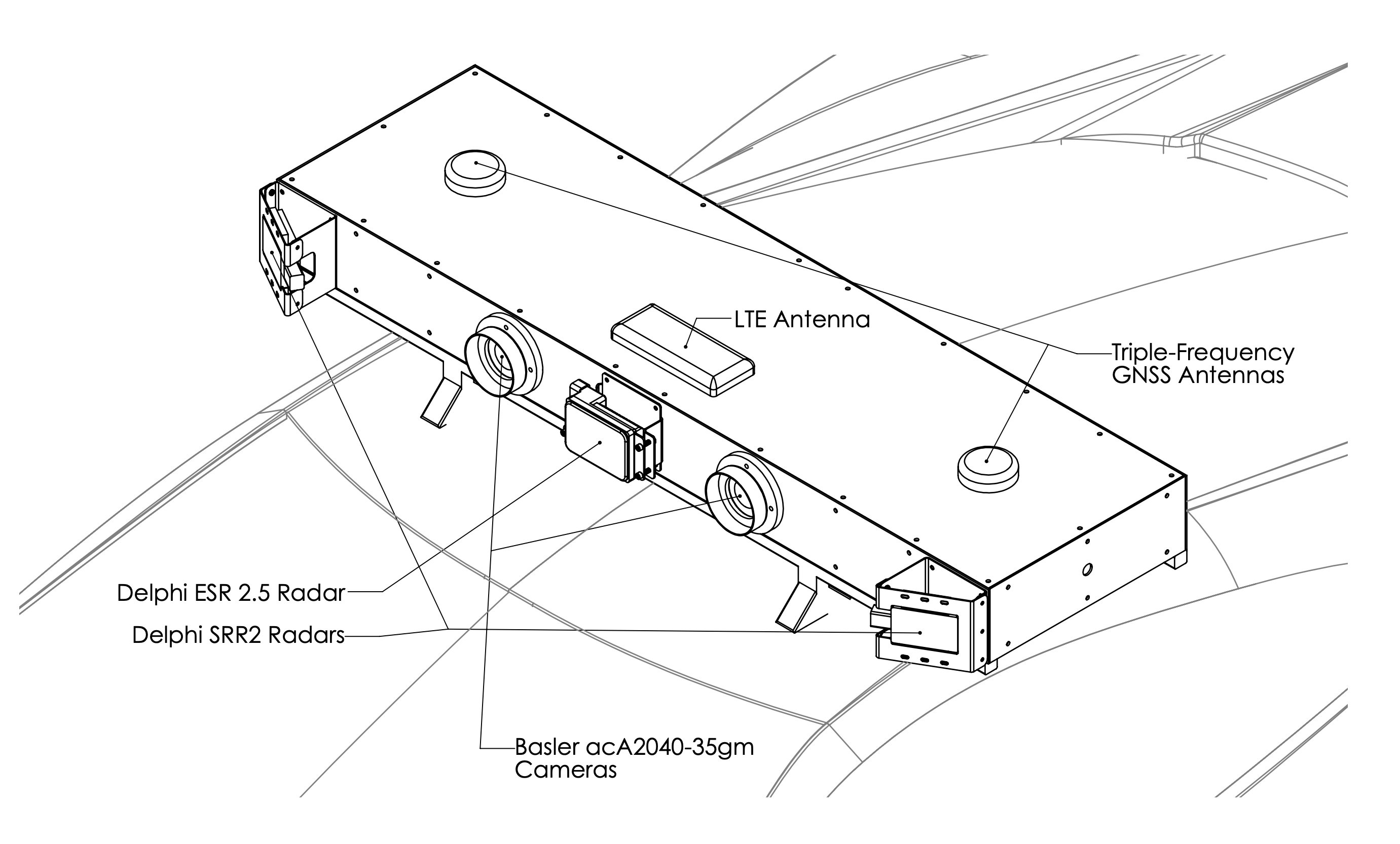
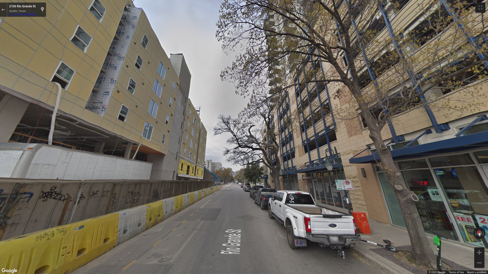
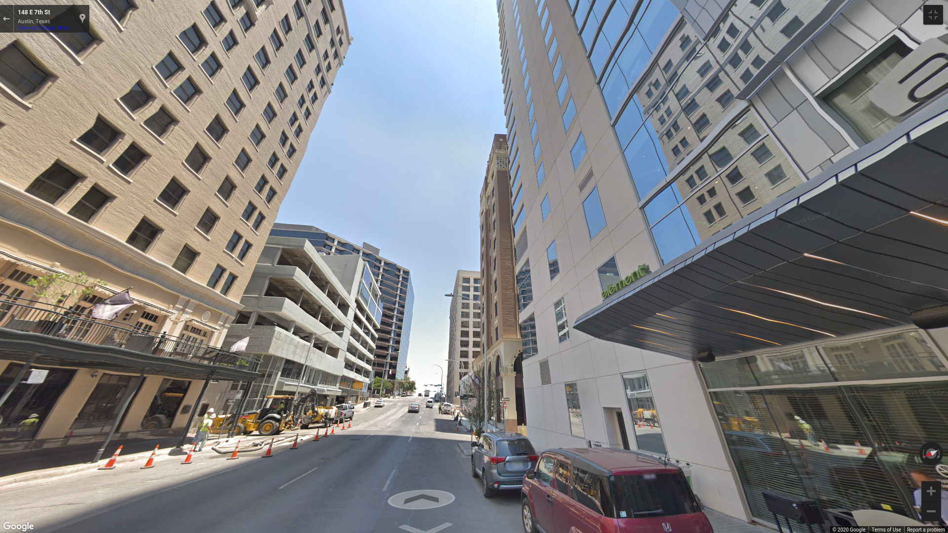
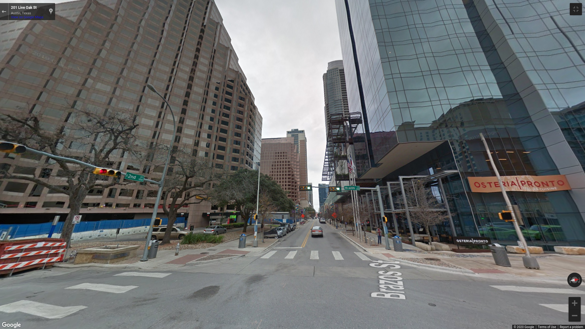
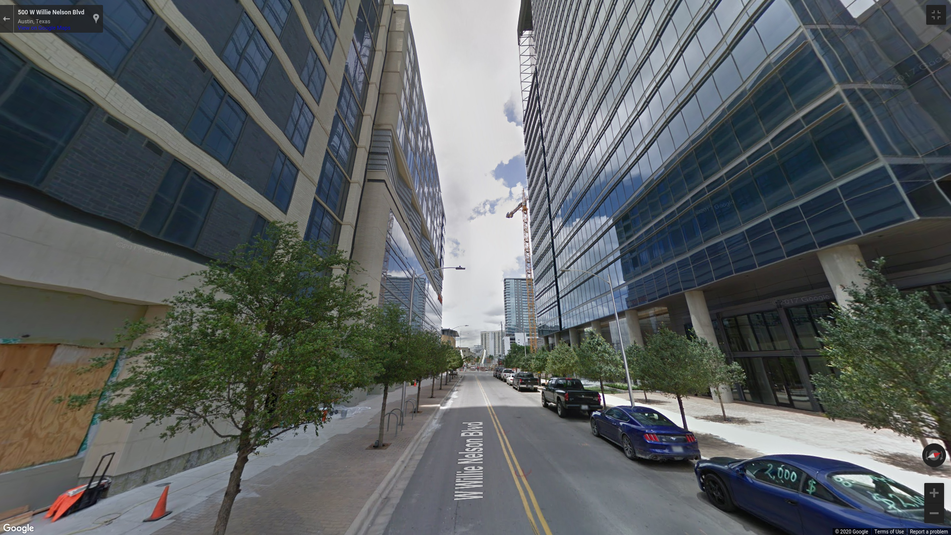
Data was gathered on the UT Radionavigation Laboratory (RNL) Sensorium, an integrated platform for automated and connected vehicle perception research. It is equipped with multiple radars, IMUs, GNSS receivers, and a lidar, as shown in Fig. 1. With the Sensorium, the RNL produced a public benchmark dataset collected in the dense urban center of the city of Austin, TX called TEX-CUP [28] for evaluating multi-sensor GNSS-based urban positioning algorithms [16]. The data captured includes a diverse set of multipath environments (open-sky, shallow urban, and deep urban) as shown in Fig. 2. The TEX-CUP dataset provides raw wideband IF GNSS data with tightly synchronized raw measurements from multiple IMUs and a stereoscopic camera unit, as well as truth positioning data. This allows researchers to develop algorithms using any subset of the sensor measurements and compare their results with the true position.
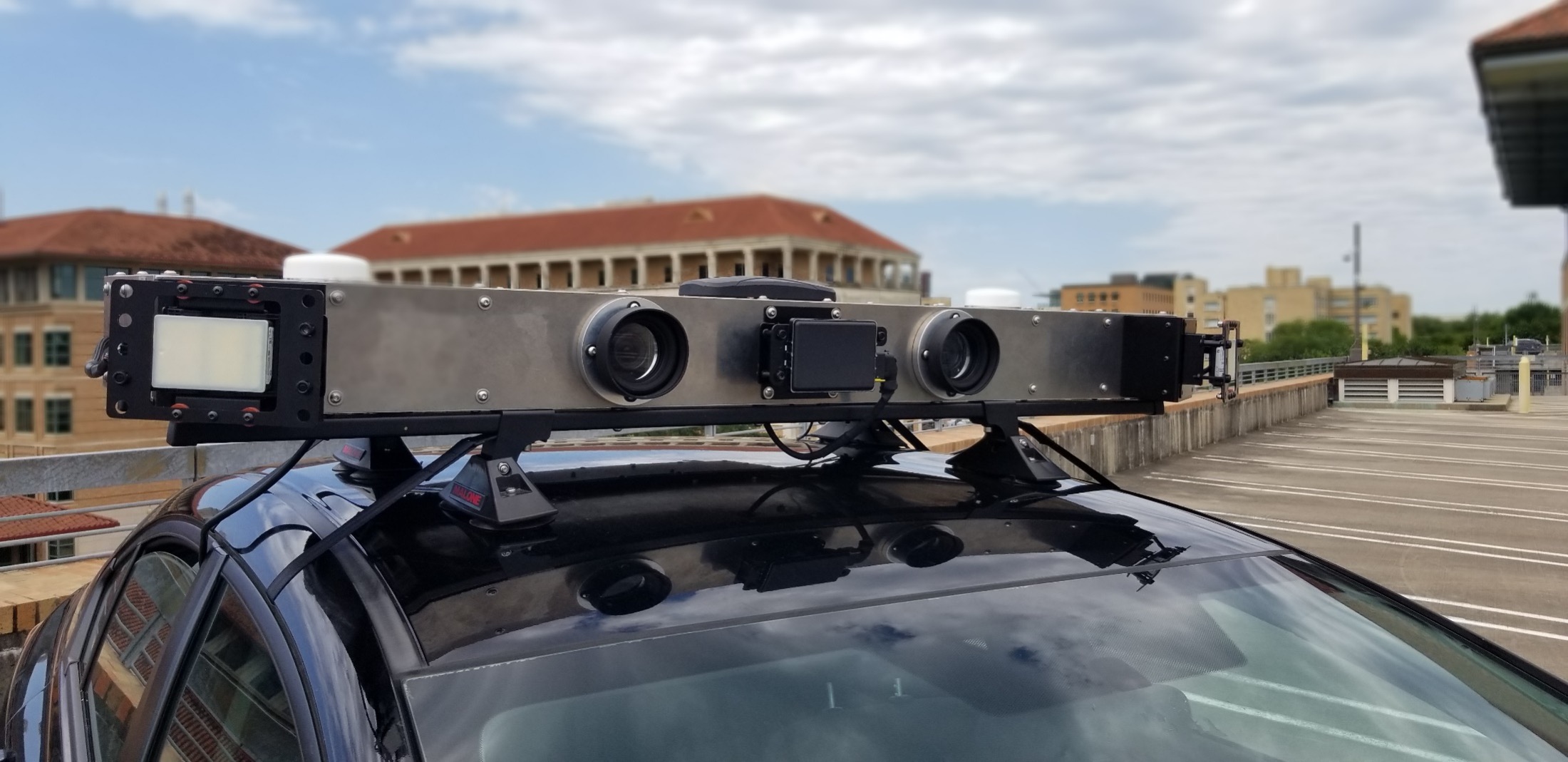
For this paper’s analysis, only the raw GNSS intermediate-frequency (IF) samples from the primary antenna and inertial data from TEX-CUP were considered, along with inertial data. Two-bit-quantized IF samples were captured at the Sensorium and at the reference station through the RadioLynx, a low-cost L1+L2 GNSS front end with a 5 MHz bandwidth at each frequency, and were processed with the RNL’s GRID SDR [29, 30, 31, 32, 33]. The tightly-coupled CDGNSS estimator described earlier was implemented in C++ as a new version of the GRID’s sensor fusion engine. The system’s performance was separately evaluated using inertial data from each of the Sensorium’s two MEMS inertial sensors. The first, a LORD MicroStrain 3DM-GX5-25, is an industrial-grade sensor. The second, a Bosch BMX055, is a surface-mount consumer-grade sensor.
TEX-CUP provides ground truth data for the vehicle position and orientation. The truth dataset was generated by a combination of sensor fusion and a tactical-grade IMU. The Sensorium is equipped with an iXblue ATLANS-C: a high-performance RTK-GNSS coupled fiber-optic gyroscope inertial navigation system. The post-processed fused RTK-INS position solution obtained from the ATLANS-C is taken to be the ground truth trajectory. Post-processing software provided by iXblue generates a forward-backward smoothed position and orientation solution with fusion of AsteRx4 RTK solutions and inertial measurements. The post-processed solution is accurate to better than 10 centimeters throughout the dataset. The effectiveness of the developed spoofing detection method is evaluated with these datasets.


Spoofing Methodology
The total signal at the victim receiver antenna is
where is the authentic signal, is the spoofed signal, and is the received noise. Under a challenging spoofing attack, contains a perfect null of the authentic signal and is entirely naturally generated, i.e., not introduced by the spoofer.
Physical-Layer Spoofing
To artificially simulate a spoofing attack, over-the-air, cable injection, and digital signal injection spoofing were considered. Over-the-air attacks are possible [34, 35, 36], but are not authorized in urban areas. A cable injection attack would be permissible for a live experiment in an urban area, and digital signal combining, as in [37], is a powerful after-the-fact spoofing technique. But in both cases it is challenging to explore a worst case spoofing attack in which the authentic signals are entirely nulled by an antipodal spoofing signal, as described in [37]. Experience with ds7 and ds8 from the Texas Spofing Test Battery (TEXBAT, [38, 39]) revealed that such antipodal spoofing is difficult to maintain under even static laboratory conditions. The remnant authentic signal from an unsophisticated and imperfect spoofing attack sullies the test statistic, making detection too easy and leading to an overly optimistic performance assessment.
Of course, nulling can also be achieved by generating a spoofing signal so powerful that it buries the authentic signal below the receiver’s noise floor. But this should not be considered a worst case attack because the overwhelmingly high received signal power from the spoofer is easily detected [5].
In short, physical-layer spoofing is challenging to conduct in such a way as to present a convincing worst-case spoofing attack to this paper’s detector.
Observation-Domain Spoofing
It is important to evaluate spoofing detection techniques on a worst-case spoofing attack, with the idea being that if the proposed detection strategy is effective on the worst-case scenario, it is even more effective on weaker attacks. Accordingly, this paper adopts observation-domain spoofing. The spoofing in the observation domain is advantageous because the authentic signal is inherently nulled, presenting a subtle attack.
The first method of implementing observation-domain spoofing is position offset spoofing. With position offset spoofing, a position offset is added to the authentic measured position to generate a spoofed position . This is accomplished by altering the pseudorange and carrier phase measurements from each satellite so that they correspond to the spoofed position with the desired additive position offset . The spoofed pseudorange and carrier phase measurements for the th satellite are constructed as follows
| (5) |
| (6) |
where and are the authentic pseudorange and carrier phase for the th satellite and and are the nonlinear (but easily linearizable) mapping functions, based on the geometry for the particular th satellite, that map the position offset to the corresponding pseudorange and carrier phase offsets.
The second method of implementing observation-domain spoofing is timestamp spoofing. With timestamp spoofing, the measurements at a particular time are reassigned to have an alternate measurement timestamp. The required modifications to the spoofed pseudorange and carrier phase measurement from each satellite induced by the new timestamp may be expressed as
| (7) |
| (8) |
where is the timestamp shift applied. The authentic observables from time are fed to the estimator as if they had occurred at time . The functions and adjust the timestamp-shifted observables to account for the transmitting spacecraft’s orbital motion and clock evolution over the interval from to .
In position offset spoofing, because , all vehicle motion reflected in is also present in . This includes all high-frequency motion due to the road irregularities and other minor movements. A detection technique designed to detect small-amplitude, high-frequency discrepancies in via the WFARC would not actually see such discrepancies unless also included simulated high-frequency content.
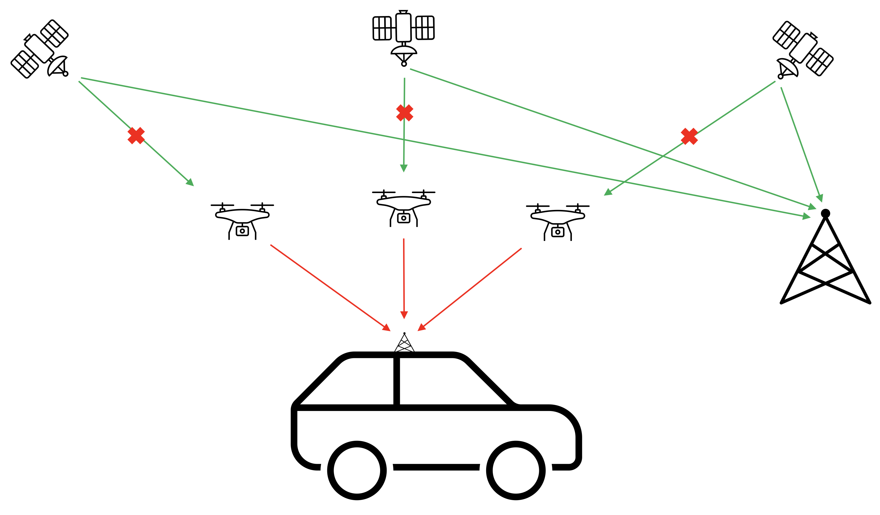
By contrast, timestamp spoofing borrows spoofed phase and pseudorange measurements from a different time instant, ensuring that high-frequency variations in these quantities will be different from those predicted by the a priori state based on IMU propagation. This is more representative of an actual spoofing attack scenario in which the attacker cannot predict the high-frequency vehicle motion. Moreover, by reducing the timestamp shift , one can realize ever-subtler attacks that are increasingly hard to detect, allowing exploration of worst-case-for-detectability spoofing.
Timestamp spoofing is also worst-case in a different sense. Because each spoofed observable is made to be consistent with the GNSS constellation geometry, the spoofing detector is presented with observables whose implied geometry is consistent with actual transmitter locations, not, for example, with a single transmitting spoofer. Moreover, because there are no irregularities in the observables that might result from an over-the-air or direct-injection attack in which the authentic signals are not perfectly nulled and so conflict with the spoofing signals, the spoofing detector is presented with observables whose variations, both in amplitude and frequency content, are entirely plausible. Thus, timestamp spoofing is representative of a case in which a well-financed attacker is able to place a single-satellite-full-single-ensemble spoofer capable of full authentic-signal nulling along the line-of-sight from the target vehicle to each overhead GNSS satellite, as illustrated in Fig. 3.
Results
The following section presents an analysis of the proposed test statistic in both the non-spoofing case and against a worst-case attack. Results with the industrial- and consumer-grade IMU are presented.
Characterization of the Null Hypothesis
This spoofing detector is premised on a hypothesis test between statistical models for the authentic and counterfeit GNSS signals. The statistics of the null hypothesis must be fully characterized so that a statistical baseline is established, against which carrier phase errors induced by spoofing in the same setting can be compared. The null hypothesis of dynamic ground vehicle scenarios includes natural effects such as blockage and multipath, which is the predominant source of error.
To analyze the null hypothesis, the WFARC was calculated in the nominal case through the entirety of the TEX-CUP dataset containing no spoofing. Because multipath is dependent on the surrounding environment, two categories were separately considered: shallow urban and deep urban. Measurements were separated into these categories manually by identifying segments of the dataset where the vehicle resided in shallow urban and deep urban areas.
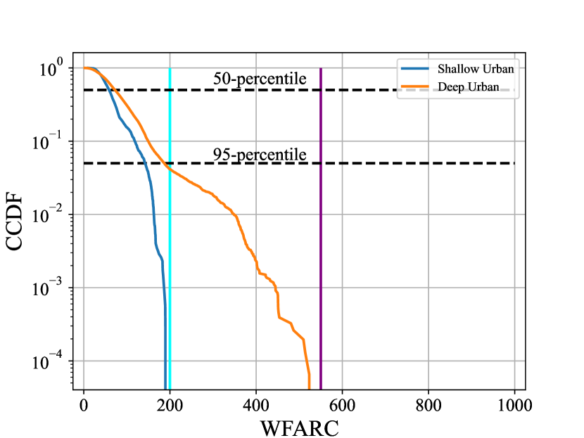
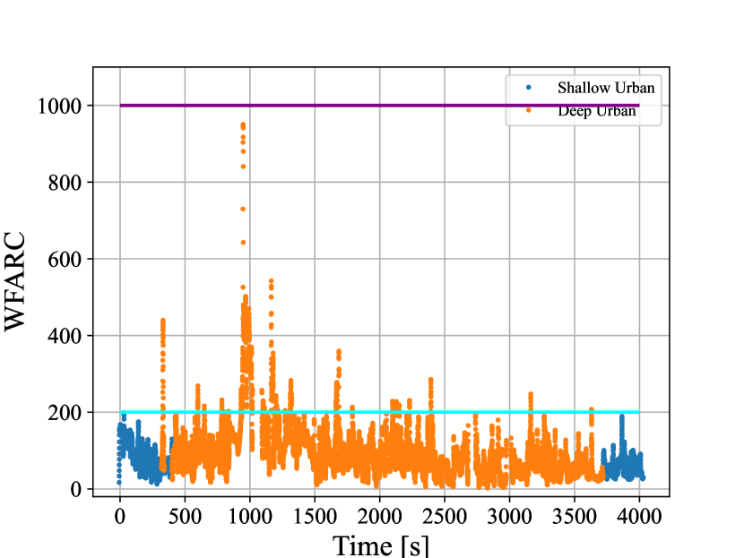
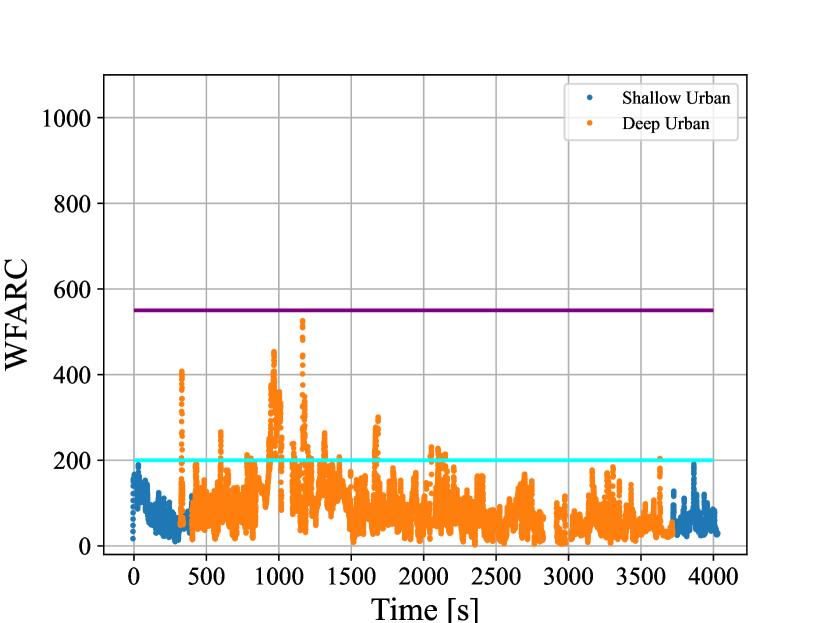
Fig. 4 shows the complementary cumulative distribution function (CCDF) of the WFARC in shallow and deep urban environments for the nominal case with industrial- and consumer-grade IMUs. The test statistic in the deep urban case has a much longer tail, which is expected because of the extreme multipath and blockage in deep urban areas. The cyan line represents the largest value of the WFARC in the shallow urban environment and the purple line represents the largest value of the WFARC in the deep urban environment. These will be the thresholds used to detect spoofing. Because the test statistic in the null hypothesis is never larger than these values, it corresponds to having a false alarm probability of zero. A chi-squared test can be used to lower these thresholds but comes at the cost of having a fixed false positive rate. Fig. 5 shows the time history of the WFARC over the TEX-CUP dataset.
It is important to note that the WFARC while using the consumer grade IMU is generally smaller than the WFARC while using the industrial grade IMU. This is expected because the consumer grade IMU is of lesser quality, thus having more variance with each measurement. The a priori state estimate from IMU tight coupling has a larger uncertainty because the estimator has less confidence in the IMU measurements, leading corrupted measurements to be more believable. Once again, in the null hypothesis, spikes in the WFARC are caused by multipath and blockage.
Performance Against a Worst-Case Spoofing Attack
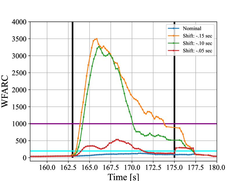
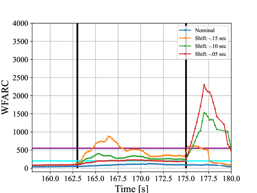
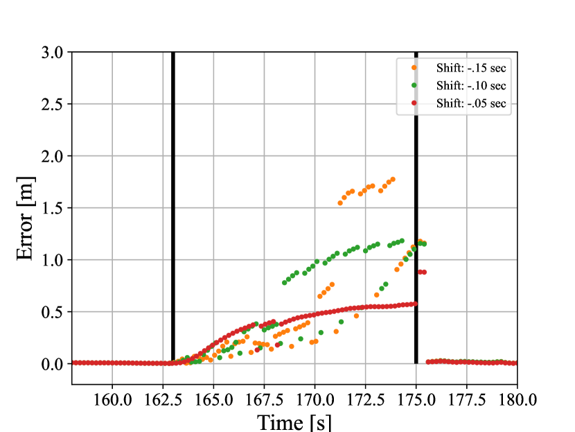
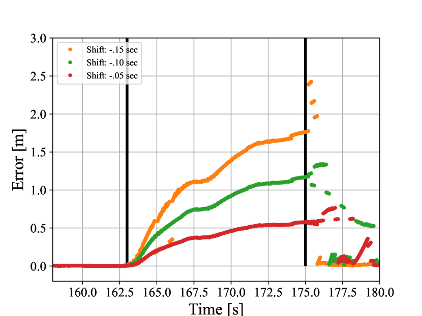
The following is an example of a worst-case spoofing attack in a shallow urban environment. In this scenario, the spoofing attack begins while the vehicle is stopped at a stoplight and continues as the vehicle begins to move. The WFARC in this scenario are shown in Fig. 6 with both industrial- and consumer-grade IMUs. The vehicle starts moving at the 163 second mark. The spoofing attack begins at the 163 second mark just before first movement and ends at the 175 second mark. As the vehicle begins to move, the position errors will grow gradually because the vehicle slowly begins to accelerate forward, inducing a position error. Three different time shift attacks in the same scenario are shown in this figure. The shift of .15 seconds is the least subtle attack while the .05 second attack is the most challenging attack because the faults are much smaller. As the vehicle begins to move, the estimator recognizes inconsistencies between the spoofed GNSS measurements and the IMU because of the tight coupling. The rise in the WFARC above the thresholds shows this disagreement that is attributed to spoofing.
With the industrial grade IMU and using the shallow urban threshold, all three time shifts spoofing attacks were identified within a second. The estimator knows that the IMU data are different than the GNSS measurements from the WFARC, much more than anything multipath would induce in the shallow urban environment. If the vehicle was in the deep urban environment, the .05 second shift spoofing attack would just be attributed to multipath. The sensitivity of the test is dependent on multipath environment.
All three attacks were identified while using the consumer-grade IMU within two seconds. If the deep urban threshold was applied, only the least challenging attack would have been identified. In all cases, the WFARC is significantly smaller compared to when the industrial IMU is used. Once again, this is because the estimator has more confidence in the spoofed GNSS measurements than the lower quality IMU. Interestingly, there is a spike in the WFARC after the spoofing attack is over. This happens because the estimator is showing trauma from the spoofing attack– the abrupt return of the true GNSS measurements were significantly different from what the previously ingested spoofed measurements were predicting.
The corresponding position errors in each attack is shown in Fig. 7. The worst-case attack (time shift of -.05 seconds) only introduces a .5 meter offset over 10 seconds, indicative of an extremely subtle attack. Even the least subtle attack (time shift of -.15 seconds) only introduces a 2 meter offset after 10 seconds, which is much more challenging than the attacks simulated in the related work.
Future Work
The results from this paper are promising. It would be beneficial to collect even more data with the Sensorium to strengthen the empirical model. Future work includes developing techniques for the vehicle to be “contextually aware” of what multipath environment it resides in. This could be achieved by monitoring certain heuristics such as SNR, tracking loop status, and the signal quality from low elevation satellites. It would also be useful to derive the true distribution of carrier-phase fixed-ambiguity residual cost. Additionally, a direct comparison between position offset and timestamp spoofing would be insightful.
Conclusion
A powerful single-antenna carrier-phase-based test to detect GNSS spoofing attacks on ground vehicles equipped with a low-cost IMU was developed, implemented, and validated. Artificial worst-case spoofing attacks were injected into a dataset collected by a vehicle-mounted sensor suite in Austin, Texas and detected within two seconds. This was accomplished by using a spoofing detection technique that capitalized on the carrier phase fixed-ambiguity residual cost produced by a well-calibrated CDGNSS solution that is tightly coupled with a low-cost IMU. The finer movements of the vehicle, such as slight steering movements and road vibrations, are the necessary unpredictable dithering a spoofer is not able to replicate. The differences between IMU-predicted and measured carrier phase values offer the basis for an exquisitely sensitive GNSS spoofing detection statistic. This paper developed the null-hypothesis empirical distributions for the test statistic in both shallow and deep urban areas, and uses these distributions to demonstrate that high-sensitivity spoofing detection is possible despite integer folding and urban multipath. Additionally, the effectiveness of consumer- and industrial-grade IMUs for spoofing detection was compared. The type of tightly-coupled IMU-GNSS estimator whose by-products the proposed detection technique exploits is not currently available on commercial passenger vehicles, but can be expected to be adopted in future automated vehicles, since it provides all-weather dm-level absolute positioning.
Acknowledgments
This work was supported in part by the U.S. Department of Transportation (USDOT) under Grant 69A3552047138 for the CARMEN University Transportation Center (UTC), and by the Army Research Office under Cooperative Agreement W911NF-19-2-0333. The views and conclusions contained in this document are those of the authors and should not be interpreted as representing the official policies, either expressed or implied, of the Army Research Office or the U.S. Government. The U.S. Government is authorized to reproduce and distribute reprints for Government purposes notwithstanding any copyright notation herein.
References
- [1] John A. Volpe National Transportation Systems Center, “Vulnerability assessment of the transportation infrastructure relying on the Global Positioning System,” 2001.
- [2] Psiaki, M. L. and Humphreys, T. E., Position, Navigation, and Timing Technologies in the 21st Century: Integrated Satellite Navigation, Sensor Systems, and Civil Applications, Vol. 1, chap. Civilian GNSS Spoofing, Detection, and Recovery, Wiley-IEEE, 2020, pp. 655–680.
- [3] Mit, R., Zangvil, Y., and Katalan, D., “Analyzing Tesla‘s Level 2 Autonomous Driving System Under Different GNSS Spoofing Scenarios and Implementing Connected Services for Authentication and Reliability of GNSS Data,” Proceedings of the 33rd International Technical Meeting of the Satellite Division of The Institute of Navigation (ION GNSS+ 2020), 2020, pp. 621–646.
- [4] Psiaki, M. L. and Humphreys, T. E., “GNSS Spoofing and Detection,” Proceedings of the IEEE, Vol. 104, No. 6, 2016, pp. 1258–1270.
- [5] Wesson, K. D., Gross, J. N., Humphreys, T. E., and Evans, B. L., “GNSS Signal Authentication Via Power and Distortion Monitoring,” IEEE Transactions on Aerospace and Electronic Systems, Vol. 54, No. 2, April 2018, pp. 739–754.
- [6] Gross, J. N., Kilic, C., and Humphreys, T. E., “Maximum-likelihood power-distortion monitoring for GNSS-signal authentication,” IEEE Transactions on Aerospace and Electronic Systems, Vol. 55, No. 1, 2018, pp. 469–475.
- [7] Humphreys, T. E., “Interference,” Springer Handbook of Global Navigation Satellite Systems, Springer International Publishing, 2017, pp. 469–503.
- [8] Montgomergy, P. Y., Humphreys, T. E., and Ledvina, B. M., “Receiver-Autonomous Spoofing Detection: Experimental Results of a Multi-antenna Receiver Defense Against a Portable Civil GPS Spoofer,” Proceedings of the ION International Technical Meeting, Anaheim, CA, Jan. 2009.
- [9] Psiaki, M. L., O’Hanlon, B. W., Powell, S. P., Bhatti, J. A., Wesson, K. D., Humphreys, T. E., and Schofield, A., “GNSS Spoofing Detection using Two-Antenna Differential Carrier Phase,” Proceedings of the ION GNSS+ Meeting, Institute of Navigation, Tampa, FL, 2014.
- [10] Reid, T. G., Houts, S. E., Cammarata, R., Mills, G., Agarwal, S., Vora, A., and Pandey, G., “Localization Requirements for Autonomous Vehicles,” arXiv preprint arXiv:1906.01061, 2019.
- [11] Ye, H., Chen, Y., and Liu, M., “Tightly coupled 3d lidar inertial odometry and mapping,” 2019 International Conference on Robotics and Automation (ICRA), IEEE, 2019, pp. 3144–3150.
- [12] Chiang, K.-W., Tsai, G.-J., Li, Y.-H., Li, Y., and El-Sheimy, N., “Navigation Engine Design for Automated Driving Using INS/GNSS/3D LiDAR-SLAM and Integrity Assessment,” Remote Sensing, Vol. 12, No. 10, 2020, pp. 1564.
- [13] Narula, L., Iannucci, P. A., and Humphreys, T. E., “Towards all-weather sub-50-cm radar-inertial positioning,” Field Robotics, 2021, To be published.
- [14] Yoder, J. E. and Humphreys, T. E., “Low-Cost Inertial Aiding for Deep-Urban Tightly-Coupled Multi-Antenna Precise GNSS,” Navigation, Journal of the Institute of Navigation, 2022, Submitted for review.
- [15] Teunissen, P. J. G., Springer Handbook of Global Navigation Satellite Systems, chap. Carrier Phase Integer Ambiguity Resolution, Springer, 2017, pp. 661–685.
- [16] Humphreys, T. E., Murrian, M. J., and Narula, L., “Deep-Urban Unaided Precise Global Navigation Satellite System Vehicle Positioning,” IEEE Intelligent Transportation Systems Magazine, Vol. 12, No. 3, 2020, pp. 109–122.
- [17] Khanafseh, S., Roshan, N., Langel, S., Cheng-Chan, F., Joerger, M., and Pervan, B., “GPS Spoofing Detection Using RAIM with INS Coupling,” Proceedings of the IEEE/ION PLANS Meeting, May 2014.
- [18] Tanıl, Ç., Khanafseh, S., and Pervan, B., “Detecting Global Navigation Satellite System Spoofing Using Inertial Sensing of Aircraft Disturbance,” Journal of Guidance, Control, and Dynamics, 2017.
- [19] Tanil, C., Khanafseh, S., Joerger, M., and Pervan, B., “An INS Monitor to Detect GNSS Spoofers Capable of Tracking Vehicle Position,” IEEE Transactions on Aerospace and Electronic Systems, Vol. 54, No. 1, Feb. 2018, pp. 131–143.
- [20] Tanil, C., Jimenez, P. M., Raveloharison, M., Kujur, B., Khanafseh, S., and Pervan, B., “Experimental validation of INS monitor against GNSS spoofing,” Proceedings of the 31st International Technical Meeting of the Satellite Division of The Institute of Navigation (ION GNSS+ 2018), 2018, pp. 2923–2937.
- [21] Tanil, C., Khanafseh, S., Joerger, M., and Pervan, B., “Sequential integrity monitoring for Kalman filter innovations-based detectors,” Proceedings of the 31st International Technical Meeting of the Satellite Division of The Institute of Navigation (ION GNSS+ 2018), 2018, pp. 2440–2455.
- [22] Kujur, B., Khanafseh, S., and Pervan, B., “A Solution Separation Monitor using INS for Detecting GNSS Spoofing,” Proceedings of the 33rd International Technical Meeting of the Satellite Division of The Institute of Navigation (ION GNSS+ 2020), 2020, pp. 3210–3226.
- [23] Liu, Y., Li, S., Fu, Q., Liu, Z., and Zhou, Q., “Analysis of Kalman filter innovation-based GNSS spoofing detection method for INS/GNSS integrated navigation system,” IEEE Sensors Journal, Vol. 19, No. 13, 2019, pp. 5167–5178.
- [24] Curran, J. T. and Broumendan, A., “On the use of low-cost IMUs for GNSS spoofing detection in vehicular applications,” Proc. ITSNT, 2017, pp. 1–8.
- [25] Psiaki, M. L. and Mohiuddin, S., “Relative navigation of high-altitude spacecraft using dual-frequency civilian CDGPS,” Proceedings of the 18th International Technical Meeting of the Satellite Division of The Institute of Navigation (ION GNSS 2005), 2005, pp. 1191–1207.
- [26] Psiaki, M. and Mohiuddin, S., “Global Positioning System Integer Ambiguity Resolution Using Factorized Least-Squares Techniques,” Journal of Guidance, Control, and Dynamics, Vol. 30, No. 2, March-April 2007, pp. 346–356.
- [27] Mohiuddin, S. and Psiaki, M. L., “High-Altitude Satellite Relative Navigation Using Carrier-Phase Differential Global Positioning System Techniques,” Journal of Guidance, Control, and Dynamics, Vol. 30, No. 5, Sept.-Oct. 2007, pp. 1628–1639.
- [28] Narula, L., LaChapelle, D. M., Murrian, M. J., Wooten, J. M., Humphreys, T. E., Lacambre, J.-B., de Toldi, E., and Morvant, G., “TEX-CUP: The University of Texas Challenge for Urban Positioning,” Proceedings of the IEEE/ION PLANSx Meeting, 2020.
- [29] Humphreys, T. E., Ledvina, B. M., Psiaki, M. L., and Kintner, Jr., P. M., “GNSS Receiver Implementation on a DSP: Status, Challenges, and Prospects,” Proceedings of the ION GNSS Meeting, Institute of Navigation, Fort Worth, TX, 2006, pp. 2370–2382.
- [30] Lightsey, E. G., Humphreys, T. E., Bhatti, J. A., Joplin, A. J., O’Hanlon, B. W., and Powell, S. P., “Demonstration of a Space Capable Miniature Dual Frequency GNSS Receiver,” Navigation, Vol. 61, No. 1, Mar. 2014, pp. 53–64.
- [31] Humphreys, T. E., Bhatti, J., Pany, T., Ledvina, B., and O’Hanlon, B., “Exploiting multicore technology in software-defined GNSS receivers,” Proceedings of the ION GNSS Meeting, Institute of Navigation, Savannah, GA, 2009, pp. 326–338.
- [32] Yoder, J. E., Iannucci, P. A., Narula, L., and Humphreys, T. E., “Multi-Antenna Vision-and-Inertial-Aided CDGNSS for Micro Aerial Vehicle Pose Estimation,” Proceedings of the ION GNSS+ Meeting, Online, 2020.
- [33] Clements, Z., Iannucci, P. A., Humphreys, T. E., and Pany, T., “Optimized Bit-Packing for Bit-Wise Software-Defined GNSS Radio,” Proceedings of the ION GNSS+ Meeting, St. Louis, MO, 2021.
- [34] Kerns, A. J., Shepard, D. P., Bhatti, J. A., and Humphreys, T. E., “Unmanned Aircraft Capture and Control Via GPS Spoofing,” Journal of Field Robotics, Vol. 31, No. 4, 2014, pp. 617–636.
- [35] Shepard, D. P., Bhatti, J. A., and Humphreys, T. E., “Drone Hack: Spoofing Attack Demonstration on a Civilian Unmanned Aerial Vehicle,” GPS World, Aug. 2012.
- [36] Bhatti, J. and Humphreys, T. E., “Hostile control of ships via false GPS signals: Demonstration and detection,” Navigation, Vol. 64, No. 1, 2017, pp. 51–66.
- [37] Humphreys, T. E., Shepard, D. P., Bhatti, J. A., and Wesson, K. D., “A Testbed for Developing and Evaluating GNSS Signal Authentication Techniques,” Proceedings of the International Symposium on Certification of GNSS Systems and Services (CERGAL), Dresden, Germany, July 2014.
- [38] Humphreys, T. E., Bhatti, J. A., Shepard, D. P., and Wesson, K. D., “The Texas Spoofing Test Battery: Toward a Standard for Evaluating GNSS Signal Authentication Techniques,” Proceedings of the ION GNSS Meeting, 2012.
- [39] Laboratory, T. R., “Texas Spoofing Test Battery (TEXBAT),” July 2017, http://radionavlab.ae.utexas.edu/texbat.