Integration of Vehicular Clouds and Autonomous Driving: Survey and Future Perspectives
Abstract
For decades, researchers on Vehicular Ad-hoc Networks (VANETs) and autonomous vehicles presented various solutions for vehicular safety and autonomy, respectively. Yet, the developed work in these two areas has been mostly conducted in their own separate worlds, and barely affect one- another despite the obvious relationships. In the coming years, the Internet of Vehicles (IoV), encompassing sensing, communications, connectivity, processing, networking, and computation is expected to bridge many technologies to offer value-added information for the navigation of self-driving vehicles, to reduce vehicle on board computation, and to deliver desired functionalities. Potentials for bridging the gap between these two worlds and creating synergies of these two technologies have recently started to attract significant attention of many companies and government agencies. In this article, we first present a comprehensive survey and an overview of the emerging key challenges related to the two worlds of Vehicular Clouds (VCs) including communications, networking, traffic modelling, medium access, VC Computing (VCC), VC collation strategies, security issues, and autonomous driving (AD) including 3D environment learning approaches and AD enabling deep-learning, computer vision and Artificial Intelligence (AI) techniques. We then discuss the recent related work and potential trends on merging these two worlds in order to enrich vehicle cognition of its surroundings, and enable safer and more informed and coordinated AD systems. Compared to other survey papers, this work offers more detailed summaries of the most relevant VCs and ADs systems in the literature, along with some key challenges and insights on how different technologies fit together to deliver safety, autonomy and infotainment services.
Index Terms:
VANETs, IOV, Vehicular Clouds, AI, AD, Safety Applications, Computer Vision, LIDAR, Cooperative Autonomous Driving.PART 1: Research Significance and Market Opportunity of Connected Vehicles and Self-Driving Cars
The race among vehicle manufacturers and IT companies to develop, test and market a reliable fully autonomous vehicular technology is motivated by the big expected annual revenue stream of smart autonomous and connected vehicles. In this part, we introduce the major technological solutions in the IoV with their industrial market opportunities and research challenges and significance
I Introduction and Research significance
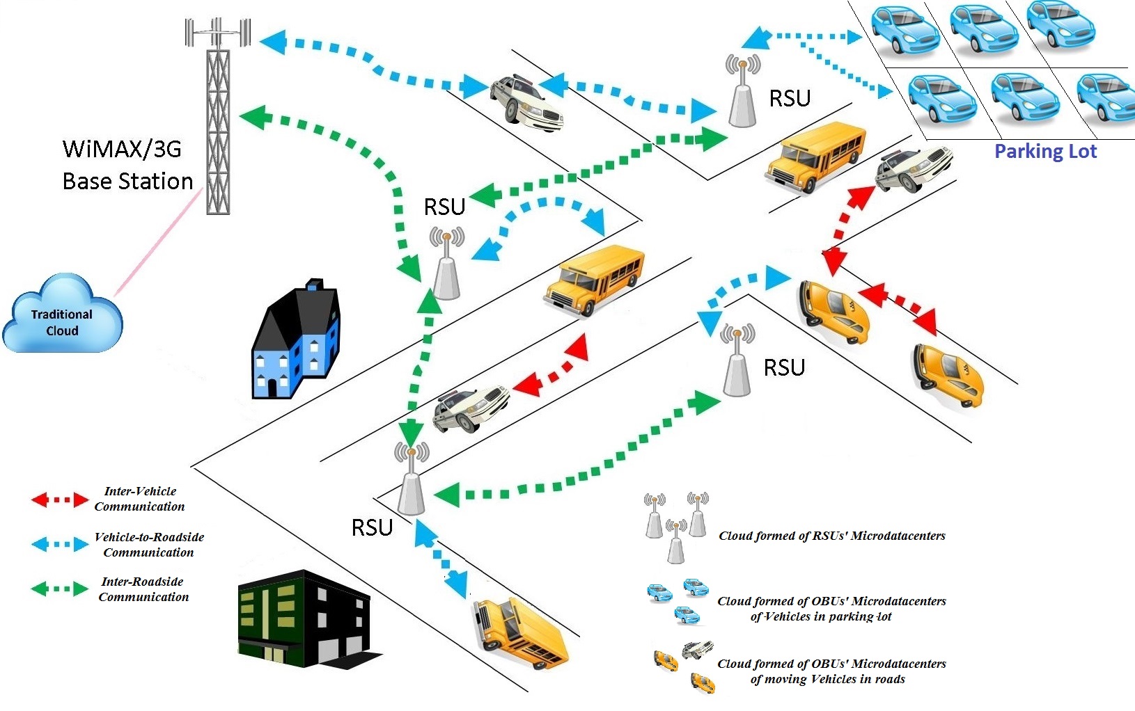
For more than three decades, researchers have increasingly infused more cyber capabilities to vehicles. Starting from basic communications to cell towers, passing through vehicle-to-vehicle (V2V) and vehicle-to-infrastructure (V2I) short range communications (a.k.a. VANETs), and reaching the recent era of VCs. On the other hand, many researchers have taken significant steps in vehicular automation with a long-term vision of reaching a full driving autonomy. Despite their obvious relevance to one another, the bridging and synergies between these two worlds have not been properly investigated. But this has recently started to attract massive interest from many companies and government agencies. For instance, the US National Science Foundation (NSF) and the US Department of Transportation (USDOT) have expressed tremendous need and importance to relate these two worlds together in several of their call for research proposals in 2017 [1]. They clearly emphasized the importance of integration and fusion of data from various input modes in order to create a deeper understanding of surroundings for safer and more coordinated AD applications. More precisely, enriched 3D scene reconstruction by different input technologies and deep learning techniques are of paramount importance to allow autonomous vehicle systems to perform effectively and safely. These directions are strongly supported by the few accidents and fatalities [2] and traffic light violations [3] made by autonomous vehicle prototypes from top industries in the market (e.g., Tesla, Uber). These incidents that could have easily been mitigated if strong connectivity, computing and distributed coordination resources among vehicles and to the road infrastructure did exist. Luckily, VANET applications for both safety and non-safety messaging have been approved by many government agencies (e.g., USDOT) and are “ready for deployment.” Forecasters estimate more than 250 million wireless-enabled vehicles by 2020 [1]. In addition, vehicle manufacturers, such as Cadillac, have already introduced commercial products (e.g., 2017 Cadillac CTS). Many modern vehicles will soon be equipped with sophisticated computing and storage capacities in their on-board unit (OBU). In addition, vehicles are getting more and more communication technology options, such as Dedicated Short Range Communications (DSRC), WiFi, 3G or Long-Term Evolution (LTE), which allow them to efficiently communicate and exchange information about their positions and intended steering commands. Furthermore, these wireless communication technologies can be used for awareness and safety through V2V beacons, as well as to enrich vehicular knowledge about their status and timings through V2I connections to static infrastructure entities such as traffic signals, street signs, etc.
In addition to the available computing capabilities, such as micro datacenters in modern RSUs as an example, modern vehicles are equipped with computing resources in their OBUs. All of these distributed resources together offer a great opportunity to form VCs. Advanced VC technologies efficiently combined with recent advances in AD can revolutionize the latter. A VC does not only provide much more enriched and informed 3D understanding of the vehicle surroundings through communications among the vehicles and the infrastructure. But also migrates current AD decision-making paradigms from single isolated operations per vehicle to a more cooperative and coordinated operation through VCC. However, it is a difficult task to create a real-time 3D map that is enriched from the mapping of data derived from distinct sensing inputs as well as premapped data that usually provides static references on streets from the cloud. Reaching this stage requires not only merging and finding the synergies of VC and AD systems, but also getting separate data from the various technologies constituting each of them. For instance, the DSRC technology enables safety and non-safety applications for VANETs, which constitute a key component in VCs and ADs. Safety applications are time critical applications that are based on V2V communications that enrich the knowledge of AD systems, while non-safety applications rely mostly on V2I communications to enable the connectivity of vehicles to VCs. The Wireless Access for Vehicular Environment (WAVE) standard partitions the bandwidth into seven channels of 10 MHz each, one control channel (CCH) to serve safety applications, and six Service Channels (SCHs) to serve non-safety applications. DSRC specifies a channel switching scheme to allow vehicles to alternate between these two types of applications. Moreover, the channel switching scheme has a lot of limitations and needs to be improved and adjusted depending on the network density and the requirements of the applications.
Thus, there is a need for constructing robust single and multi hop communications for VCs in order to perform the desired coordinated role for multiple non-safety or commercial applications. This creates many challenges to optimize their coalition formation, manage the cloud resources efficiently and distributively, and make the technology more cost effective.
On the other hand, many deep learning and artificial intelligence systems and algorithms have been developed and tailored to enhance autonomous vehicles’ 3D surrounding reconstruction and image flow recognition from both camera feeds and LIDAR point clouds. End-to-End recognition and driving decisions frameworks have also been recently studied. However, many challenges still exist in terms of the accuracy of the resulting learned environment and decisions taken by autonomous vehicles, especially in very low visibility (e.g., foggy weather, camera facing the sun) and out-of-sight scenarios (e.g., vehicles hidden by buildings/trucks at intersections), in which camera and LIDAR technologies can easily fail.
This article starts by providing a comprehensive survey, over-viewing the current research in the literature about both VC and AD technologies, and illustrating their on-going challenges and limitations. In addition, we shed some light on the recent work towards merging these two worlds to develop a synergistic framework for a more informed, advanced and coordinated AD systems. The outline of the contributions of this paper relative to the recent literature can be summarized as follows:
-
•
Present how different communications technologies and protocols fit together to form Vehicular networks and clouds.
-
•
Provide an overview of some of the VANET and VC challenges presented in the recent literature and provide a summary of the related research work. Moreover, we present the relation between these technologies and other emerging technologies, such as big data analytic and cloud computing.
-
•
Unlike previous surveys, this survey provides not only the characteristics of the existing Media Access Control (MAC) protocols, but also how to optimize them to improve the performance of safety and non-safety applications in VCs.
-
•
Due to the rapidly-changing topology and high node mobility in VANETs, we discuss different routing algorithms and their performance evaluation based on the transmission strategy, delay sensitivity and homogeneity or heterogeneity between networks.
-
•
We classify various VCC architectures and expose their advantages and limitations.
-
•
We review various perceptions only, LIDAR only, and mixed approaches for objects recognition, tracking and scene flow estimation surrounding the self-driving vehicle.
-
•
Review current research attempts ranging from pedestrian tracking, free space and road segmentation to more complex systems offering autonomous navigation based on the different up-to-date modalities of sensors.
-
•
We present and compare recent Simultaneous localization and mapping (SLAM) based methods for vehicle localization based on surrounding on the move data recorded from different sensors.
-
•
We present various open research and technical challenges of mapping and fusion techniques based on the sensing technology, alignment type (post or pre) and the data provenance from the VC or the vehicle sensors.
-
•
We introduce recent works aiming to align the information obtained from camera feeds, LIDAR point clouds, and DSRC Basic Safety Messages (BSMs) in order to construct a more enriched and informed 3D understanding of autonomous vehicle surroundings.
-
•
We shed light on prospective research directions to develop both more robust multimodal data merging and deep learning schemes for AD, and advanced computing and optimization frameworks for safer and more coordinated AD systems.
II Market Opportunity OF CONNECTED VEHICLES AND AD
Connected and autonomous vehicles offer a promising market opportunity for on board communications equipment manufacturers, autonomous steering, Internet Service Providers (ISPs), LIDAR and RADAR scanners, AI vehicle computing platforms, etc.
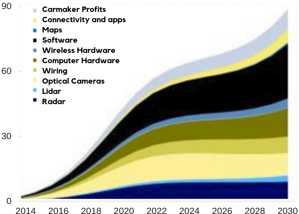
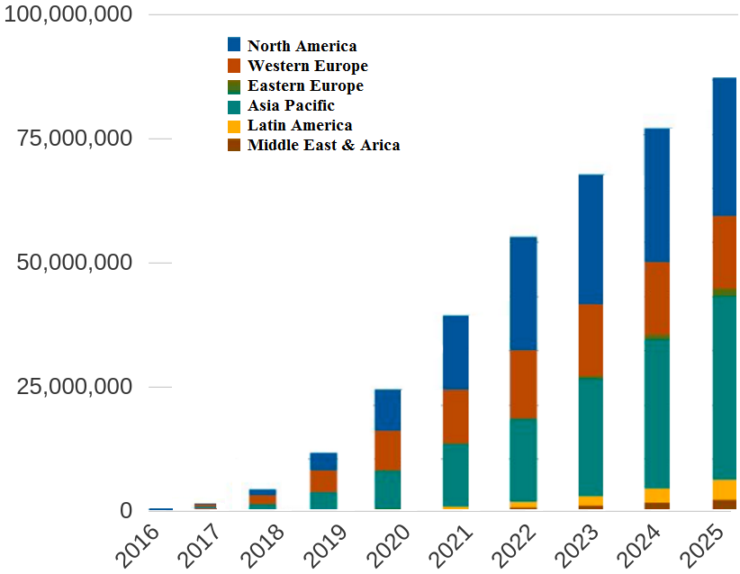
Appealed by the estimated $87 billion market opportunity by 2030 [4], traditional vehicle manufacturers are thriving to put the pedal to the medal while they contest with technology companies to put driver assistive features of fully automated self-driving technology in vehicles. The software systems, computation hardware, and optical cameras are projected to form the most significant economic impact in the self-driving vehicles market, as presented in Fig. 1. The National Highway Traffic Safety Administration (NHTSA) has issued a notice of proposed rule-making (NPRM) to mandate vehicle manufacturers to mount DSRC radios for V2V communications in new vehicles sold in the USA market starting in 2020 [5]. Consequently, this is expected to produce a rapid expansion of ubiquitous V2V and V2I connectivity, as the number of projections shown in Fig. 2 makes the leap to self-driving vehicles even smaller. Regardless of the on board communications, connectivity to the cloud has a substantial and profound impact on businesses and the society. It enables a variety of key vehicular applications such as software updates, real-time traffic with parking information, charging stations location and availability, and vehicular apps that evolve the deployment of autonomous vehicles.
Specifically by 2020, projections estimate that the connected vehicle market is expected to create a total revenue of $141 Billion [7]. In addition to the aforementioned driving related features, connected vehicles would gain from cloud services including advanced infotainment systems, commercial applications, and deep analysis and diagnostic systems. Based on different connectivity solutions, the annual global sales are expected to gain a tremendous growth especially for the embedded and integrated solutions, as shown in Fig. 3. The embedded connectivity solutions enable connectivity, intelligent computation and built in services and applications running inside the vehicle. While tethered solutions rely on the separation of the applications, remain inside the vehicle, and the connectivity is delivered externally (e.g., using a phone). The integrated solution (usually called bring-you-own-device) enables connecting a device that has the computation, applications and connectivity to the vehicle’s dashboard.
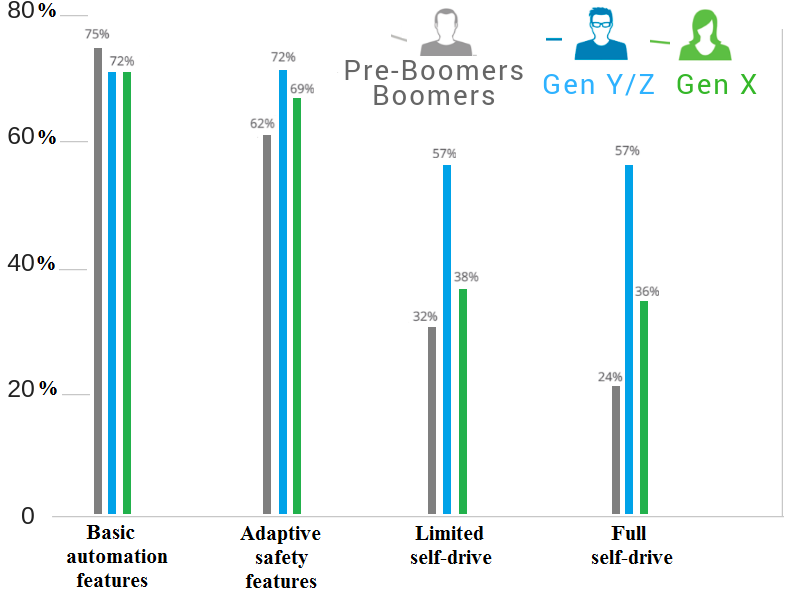
US consumer trust and interest in simple, partial, and fully automated driving systems have increased as detailed in Fig. 4 presented by the study in [TrustAutonomousVehiclesTheRaceToAutonomousDriving]. Among all the levels of vehicle automation technologies, younger consumers in the US have shown strong interest in systems with emphasis on basic automation, adaptive safety, limited autonomous driving and full autonomy. These survey findings presented more details about the trust and the interest of US customers between 2014 and 2016, which definitely point to a fast-pace growth demand towards the AD systems.
However, this expected progression of spreading the connected VC related services and the AD systems is very related to the provision of high Quality of Service (QoS) connectivity for vehicles, and regulatory actions.
III Remainder of the paper
The overall structure of this article is organized into three major parts. Part 2 provides a comprehensive survey of the key challenges encountered in VANETs and VCs. In Section IV, we introduce the various communications technologies used in vehicular networking. Heterogeneous VANETs are classified in Section VI. In Section VII, we evaluate the numerous MAC protocols in VANETs. Different types and strategies for traffic modelings and networking of safety and non-safety applications are introduced in Section IX. In addition, we present recent optimization schemes for MAC protocols and discuss the effect of the Synchronization Interval (SI) in the reliability of the vehicular applications. In Section X, we compare the different ideas of VC formation based on various data center types and the heterogeneous communication technologies in ad-hoc cloud networks. We also show how differentiating the cloud performance can improve the QoS of the non-safety applications. Most common security threats in vehicular communications and VCs are described in Section IX. Part 3 presents a thorough overview of the literature and the on-going open problems in AD and its enabling 3D scene reconstruction using camera and LIDAR technologies. In Section XII.A, we present mediated perception approaches for object recognition from cameras only. In Section XII.B, we present the prediction of driving decisions through direct perception approaches. While in Section XII.C we illustrate the behavior reflex approach usage to directly map sensed input to the driving action that has been previously taken. The various LIDAR based perception approaches for objects detection and recognition from a point cloud are developed in Section XII.D. The mixed techniques based on mediated and LIDAR perceptions are iterated in Section XII.E. Sections XIII.A, XIII.B and XIII.C are dedicated to vehicle localization based on visual odometry, LIDAR and Combined Visual-LIDAR odometry, respectively. Afterwards, Part 4 sheds light on the recent advances in merging these two worlds for advanced and coordinated AD systems. In Section XIV, recent techniques to post-align pre-learned scenes for camera feeds, LIDAR scans, VANET BSMs, and infrastructure messages are illustrated. Future research directions on pre-fusion of the data obtained from this multimodal input (i.e., camera, LIDAR and VANETs) are highlighted in Section XV. In addition, potential research tools that utilize the resulting enriched and informed environment recognition to achieve AD cooperation and coordination for AD are presented in Section XVI. Finally, examples of integrating VCs and AD systems are presented in Section XVII. In Part 5, we present the major open challenges facing the effective widespread utilization of VCs as well as the fully autonomous vehicles, as detailed in Section XVIII. Finally, we conclude the paper by summarizing the important take-away messages of this article in Section XIX.
PART 2: KEY CHALLENGES IN VANETS AND VCS
The major studied building blocks of vehicular networks can be classified into four major sections; namely: communications technologies, cellular and DSRC architectures, network architectures and VANET MAC protocols.
The vehicular networks are intended to manage the connectivity of vehicles from and to VCs and to support access independently of the clouds’ architectures and challenges. This section focus on the overall challenges in VCs and provides a thorough summary of the most relevant architectures developed in the literature.
IV Vehicular Communications Technologies
Modern vehicles are mostly equipped with various communications technologies such as WiFi, DSRC, 3G, and LTE. This is considered a valuable advancement, but ensuring that vehicles use the most appropriate communication technologies is a very challenging problem. This is the case for each of these technologies and the trade-off between their pros and cons. The maximum range of WiFi-direct can extend to 200 meters with a highest data rate of 11 Mbps. Whereas LTE is a paid mobile communications technology that has a wider connectivity coverage than DSRC and WiFi, but provides a lower data rate that ranges from 5 to 12 Mbps. Even though DSRC has a maximum data rate of up to 27 Mbps, its maximum range is 1000 meters.
IV-A Dedicated Short-Range Communications (DSRC)
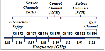
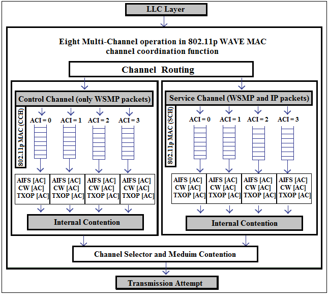
The DSRC [8] standard was coined by the Federal Communications Commission (FCC) [9] to operate over a dedicated 75 MHz spectrum band around 5.9 GHz in the USA [10] and partitions the bandwidth into seven channels. The DSRC has been adopted to enable two classes of applications (Safety and Non-Safety) for VANETs. One control channel CCH number 178 which are used to serve safety applications. Six SCHs (172,174,176,180,182,184) to serve non-safety applications as detailed in Fig. 6.
IV-B Wireless Access for Vehicular Environments (WAVE)
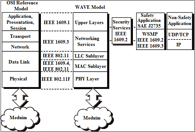
The CCH and the SCHs have four different access categories (ACs) and different priorities for each one of them to access the medium. In many urban areas, vehicles can use the free WiFi connectivity and might also use paid cellular base stations (e.g., 3G, LTE or 5G) connectivity to access the Internet depending on the application requirements, QoS, and cost. Vehicles having only DSRC connectivity may also use their neighboring vehicles as a gateway to the outside world. It is kind of tricky how to handle all these types of connections in a sophisticated and cost efficient manner. In this section, we mainly focus on the DSRC emerging technology and WAVE standard of VANETs, then we describe different MAC protocols that have been proposed in many research attempts. With respect to the OSI reference Model in Fig. 7, the WAVE model is divided into four categories:
-
•
IEEE 1609.1 [12]: standard used as a guide to manage the resources in VANET entities (e.g., RSUs, and OBUs).
-
•
IEEE 1609.2: standard defined as the WAVE security services for applications and management of messages that are responsible for ensuring the anonymity, authenticity and confidentiality of the vehicular safety and non-safety packets.
-
•
IEEE 1609.3: standard developed as a guide for WAVE network configuration management and WAVE Short Message (WSM) transmission and reception.
-
•
IEEE 1609.4 [13]: standard responsible for WAVE Multi-Channel Operations that provides the DSRC frequency band with coordination and management of multiple connections by adopting the IEEE 802.11p standard for MAC and Physical Layer (PHY) specifications.
IV-C DSRC Channels Switching Assignment
DSRC specifies a channel switching scheme that allows vehicles to alternate between the transmission of safety and non-safety packets. The DSRC standard recommends that, during a SI which is 100ms long, vehicles should visit the CCH to exchange their status messages with neighboring vehicles. The SI is composed of Control Channel Interval (CCHI) and Service Channel Interval (SCHI), both intervals are used to access the CCH and the SCHs for sending safety and non-safety application packets, respectively.
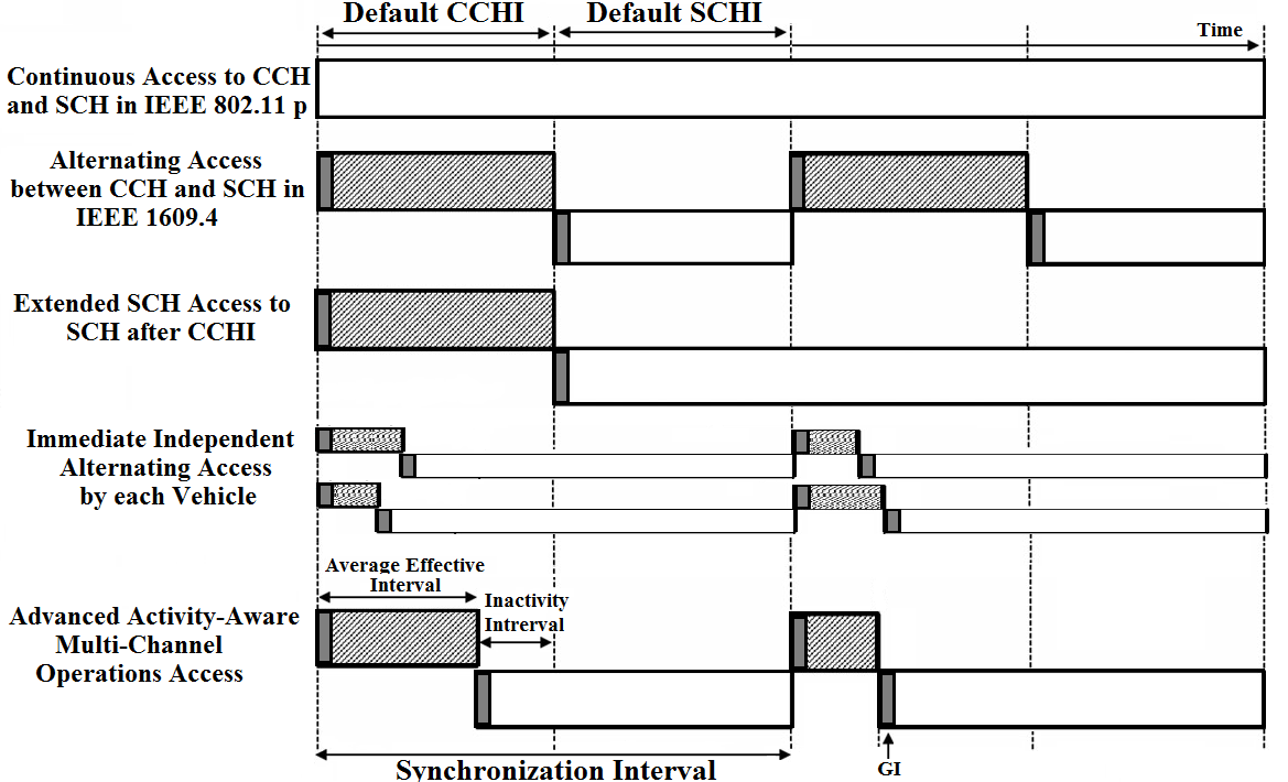
Many research studies have been conducted to optimize the CCHI and the SCHI to guarantee a fair split of the SI between the safety and non-safety applications and to prioritize applications based on their QoS requirements. A higher time share of the CCH from the SI leads to more reliable safety applications.
In [14], the authors developed two algorithms to optimize the length of the CCHI so that non-safety applications have a fair share of the SI. In [11], the authors developed an advanced awareness scheme of channel inactivity to dynamically achieve optimal interval switching based on the average effective interval utilization.
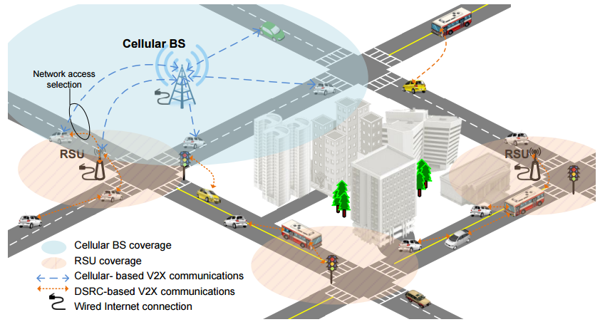
V Cellular Technology and DSRC-Cellular hybrid Architectures
Due to the aforementioned limitations of DSRC, many research attempts have raised interest to investigate the support of cellular technologies (e.g., 3G, LTE, 5G) for vehicle to any (V2X) communications and usage of both DSRC and cellular communications, as shown in Fig. 10. Cellular technology is gaining momentum in the research community over DSRC because of the following enablers:
-
•
The capacity of dense networks to support high bandwidth demand of vehicles and cellular users at the same time. In such scenario, the performance evaluation of the downlink with unicast and broadcast vehicular messages is studied in [15] for LTE based systems.
-
•
Reduced frequency of horizontal handoff of vehicles between BSs is guaranteed through the large cellular coverage.
-
•
Unlike DSRC poor Non-Line-Of-Sight receptions, cellular LTE systems provide potentially better coverage as demonstrated in [16].
-
•
Cellular is widespread and mature technology that accelerates the deployment of V2X communications and does not require new infrastructure facilities like DSRC.
On the contrary, current research studies that investigate sending vehicular safety messages using LTE [17], and cross-traffic assistance of vehicular safety messages using UMTS and LTE [16], do not account for traditional cellular network traffic. Even though the downlink and uplink transmission rates between the BS, as the access network connecting to the Internet, and vehicles in LTE (up to 300 and 75 Mb/s, respectively) are higher than in DSRC, LTE cannot provide the same awareness update rate and latency for Cooperative Awareness Messages (CAM) like ”offered” using DSRC [16]. To put it differently, the centralized nature of cellular networks imposes that messages should be sent from vehicles to BSs that unicast or broadcast messages to other vehicles. In other words, instead of directly sending safety messages using DSRC, in cellular networks safety messages have to pass by the BS. Therefore, the use of the cellular technology results in lower awareness update rate and higher latency for disseminating delay critical safety-related applications. Additionally, several challenges limit transmission of the messages received by the BS:
-
•
Unicasts the received safety messages to the relevant vehicles subject to the the initial sender’s safety. The Work in [18] shows that in case of unicast of messages from the BS, the uplink has lower traffic load than the downlink and it becomes a bottleneck. One affordable solution that is available in 3GPP and higher standards is the use of multimedia broadcast and multicast services (MBMS), and the evolved MBMS (eMBMS) for safety message dissemination over cellular communications.
-
•
Broadcasts the received safety messages to all the vehicles in its cell coverage area. Ultimately every vehicle receives all the safety messages sent by the BS, regardless of whether or not it belongs to the same zone of relevance to the sending vehicle. An alternative solution that might have a high latency is to create multicast groups [19] with eMBMS that are concerned with the safety messages that the BS transmits.
Detailed comparisons between the DSRC-cellular and pure cellular architectures are summarized in Table. I
| Architecture |
|
|
Reference | Application |
|
|
||||||||
| Pure Cellular Architecture | Hierarchical | Fixed | [21] | Any application | Cellular | No Aggregation | ||||||||
| Dynamic | [22] | Any application | Cellular | No aggregation | ||||||||||
| DSRC-Cellular Hybrid Architecture | Flat | Performance Centric | [23] |
|
|
|
||||||||
| [24] |
|
|
|
|||||||||||
| Data-centric | [25], [26] | Routing |
|
|
||||||||||
| Hierarchical | Dynamic | [27], [28] | Video Sharing | V2V and V2I |
|
|||||||||
| Fixed | [29] |
|
V2V and V2I |
|
VI Vehicular Network Architectures
In this section, we survey the most recent research progress on vehicular network architectures, as detailed in [30]. This can be classified into three major categories based on the parts intervening in the network:
-
•
Stationary cellular and/or RSU based networks used as access points to provide services to vehicles, such architecture is detailed in [31].
- •
-
•
Hybrid network architecture that combines cellular and RSU with mobile vehicles as ad-hoc networks, as described in [34].
Vehicular networks based on fixed infrastructure are eventually unfeasible because of the high cost associated with infrastructure deployment. Most of the research attempts focus on VANETs and hybrid networks. VANETs are created by applying the principles of mobile ad-hoc networks (MANETs) for spontaneously creating a wireless network of moving vehicles to increase safety through DSRC communications or collaboration to better utilize the communications capabilities of vehicles in the same area. VANETs support a wide range of applications that vary from simple one hop [35] information dissemination of CAMs [36] to multi-hop [30] dissemination of messages over vast distances [37]. VANETs can be divided into three types depending on their building blocks; namely, connected vehicles that rely only on V2V communications, coalition of RSUs and OBUs with V2V and V2I communication, and interconnected infrastructure equipment (e.g., Traffic light, pavement markers, cameras, etc.). In contrast to MANETs, modeling the moving nodes in VANETs is less complex especially that most of vehicles are restricted in their range of motion by paved highways/roads with traffic lights. The key issue of network selection is when vehicles are connected to many types of infrastructure nodes like RSUs with DSRC communications access and/or cellular nodes with 3G/LTE access and/or WiFi. Thus, it renders the decision making regarding the best type of connectivity very critical given vehicular application requirements, cost, availability expectations, etc. These infrastructure nodes have to be utilized efficiently in the best manner that reduces handover latency from one network to another and to avoid bottleneck network congestion. In [38], authors studied the use of IPv6 based on its efficient Internet traffic flow management over heterogeneous technologies. Their model is based on using the RSUs to act as IPv6 routers and to handle the convergence of DSRC and cellular technologies while vehicles get in or out of their coverage.
VII VANET MAC PROTOCOLS
A major challenge in VANETs is the frequent changes in the network topology. VANET MAC protocols have to reduce the medium access delay for safety applications and to handle all the vehicles joining or leaving the network. In this paper, we classify several MAC protocols that have been proposed for VANETs into five major categories; namely, contention-based protocols, contention-free protocols, hybrid protocols, dedicated short-range communications-based protocols, and directional antenna-based protocols. In VANETs, Time Division Multiple Access (TDMA), Frequency Division Multiple Access (FDMA), or Code Division Multiple Access (CDMA) are very difficult to implement because of the need to dynamically allocate slots, channels, or codes without centralized control.
| Channel Access | Channel Separation | Channel Assignment | Channel Coordination |
| Hybrids | Contention-free methods | Distributed | *** |
| Centralized RSU |
ACFM [39]
|
||
CBRC [40]
|
|||
| Contention-(free and based) methods | Distributed |
CS-TDMA [41]
|
|
SOFT-MAC [42]
|
|||
DMMAC |
|||
HER-MAC |
|||
| Centralized Cluster-head | CBMMAC |
||
CBMCS |
|||
| Centralized RSU | RMAC |
||
| Contention-Based | IEEE 802.11p [43] | Distributed |
CSMA with DEA [44]
|
DCAS [45]
|
|||
| Centralized RSU |
p-persistant CSMA with CEA [44]
|
||
| Contention-free | TDMA | Distributed |
VeMAC [46]
|
VeSOMAC [47]
|
|||
STDMA [48]
|
|||
CFR MAC |
|||
ASTA |
|||
| Centralized Cluster-head |
CAH-MAC[49]
|
||
CBMAC[50]
|
|||
ADHOC MAC[51]
|
|||
A-ADHOC [52]
|
|||
TC-MAC[53]
|
|||
CBT[54]
|
|||
| Centralized RSU |
UTSP [55]
|
||
| FDMA | Distributed |
dFDMA[56]
|
We highlight the MAC protocols using TDMA by implementing time-slotted access channels while taking into consideration the major requirement of clock synchronization between vehicles. TDMA allocates the disposed bandwidth to all the vehicles by creating different time frames and dividing each frame into several time slots so that vehicles send their data during one or more time slots. Vehicles can access every frame and they receive during the time slots allocates to neighboring vehicles. The rapidly changing topology in VANETs is induced by the fast moving vehicles, which imposes that an efficient MAC protocol must be implemented to adapt to these changes in the network either through the use of specialized RSUs, or using cluster head vehicles, or in a distributed manner. In contrast to TDMA time slotted accesses, MAC protocols developed as part of the IEEE 802.11p standard offer a significant increase in the network throughput while reducing the transmission delay by using CCH and SCHs with reservation-based access and dynamic assignment of channels to resolve the hidden terminal problem [57]. Ko et al. [58] developed a directional antenna-based MAC protocol that can be applied to vehicular environments so that it allows a vehicle to block the communication to avoid the hidden node problem.
VIII Network Selection Schemes and Routing Protocols in VANETs
The dynamic nature of nodes in VANETs offers additional challenges of finding and maintaining routes for vehicular application packets. In addition, the high mobility induces difficulties while routing in homogeneous or heterogeneous networks. The routing challenges in VANETs include:
-
•
Routing in Homogeneous Networks: most of the traditional VANET routing protocols have one common assumption that all packets are transmitted via a short distance wireless technology (e.g., WAVE standards). As a result, those routing algorithms’ performance is often analyzed and compared relative to a horizontal handoff. The work in [59] presents the scenario of a data transmission session transferred from one Point of Attachment (POA) to another with the same access technology and in the same network. In [60] and [61], the authors studied a use case of horizontal handover to transfer an Internet video streaming session of a vehicle while moving from one coverage area of an RSU to another.
-
•
Routing in Heterogeneous Networks: The main reason why IoV networks are more complicated than VANETs is that they often include different radio access technologies, thereby leading to a heterogeneous network. Vertical handoff is a classical problem in heterogeneous networks, including the IoV, with different access technologies that have different characteristics (e.g., bandwidth, frequency band, modulation and coding scheme). It offers the possibility to switch from one access technology to another based on performance, availability or cost reasons, while maintaining active connections. The authors in [62] present the scenario of a data transmission session transferred from one POA to another with a different access technology and in a different network. In [63], Lee et al. proposed a vertical handoff (VHO) algorithm for more seamless integration of 3/4G wireless data networks, VANETs and IEEE 802.11 WLANs.
VIII-A Network Selection Schemes
One way to increase the vehicular networks performance in terms of throughput and delay is to minimize the cost related to handovers. Network selection schemes are effective processes to make handover decisions depending on handover triggers. They are considered as measures to derive the handover decisions and can be classified into user-centric, network-centric or hybrid, as illustrated in details in Table III. In cases where there is a necessity for network improvement or handover needs to be applied, user and network related information are provided to the network selection scheme in order to make the network selection’s decision be more flexible.
| Handover Trigger | Type | Metrics | References | ||||
|---|---|---|---|---|---|---|---|
| User-centric |
|
|
|
||||
| Cost |
|
[65] | |||||
| Network-centric | Data Traffic | Data delivery ratio and delay | [66] | ||||
| Load Balancing | Capacities of BSs and RSU | [24] | |||||
| Fairness Guarantees | Between users | [67] | |||||
| Network Throughput | Maximize support of user demands | [68] | |||||
| Hybrid | Utility objective based on user- and network- centric handover | Mapped IEEE 1609.4 traffic classes with cellular standards to guarantee expected QoS | [62] |
VIII-B Routing Protocols in VANETs
Finding and maintaining routes in VANETs is a very challenging task especially in networks with very changing topology due to the dynamicity of the vehicular nodes. Similar to IoV, several classical protocols applicable to MANETs are developed, such as: Ad-hoc On Demand Distance Vector (AODV) [69], Destination-Sequenced Distance-Vector (DSDV) [70] and Dynamic Source Routing (DSR) [71]. Additionally, many research attempts have considered the properties of vehicles and developed geographic protocols like Greedy Perimeter Stateless Routing (GPSR) [72] and Greedy Perimeter Coordinator Routing (GPCR) [73]. A detailed taxonomy of existing routing protocols is given in Table IV. These protocols are classified in this section based on:
-
•
Required Routing information to perform routing: topology, position, map and path.
-
•
Transmission strategies: geocast, broadcast and unicast.
-
•
Target network type: homogeneous and heterogeneous networks.
VIII-B1 Required Routing Information
The routing decisions are performed by the routing protocols depending on the information provided about the topology of the network, the position of the node, street map details or the path of the packet to be routed from one vehicle to another. In this section, we present the most relevant state of the art VANET routing protocols based on the required information needed to perform packet routing.
A Position-Based Routing Protocols
Position-based routing protocols use the positions of vehicles given by the geographical location information obtained from street maps or on-board Global Positioning System (GPS) systems to make packet forwarding decisions. The GPSR protocol [72], primarily developed for mobile wireless networks, formulates the packet forwarding decisions based on the positions of the nodes. It employs greedy forwarding techniques of packets to vehicles that are progressively closer to the destination. If the greedy path could not be established then the forwarding node forwards the packet based on a planar graph traversal after switching the packet to its perimeter mode. Then it resumes the greedy task when the forwarded packet reaches a node closer to the destination.
GPSR performance degrades significantly in city scenarios because of obstacles like buildings, which lead to restricted direct communications between nodes. In addition, switching to the planarized graph to find the routing topology and running the greedy algorithm or face routing degrades the performance of packet routing significantly because of excessive delays.
Lochert et al. [73] developed the GPCR protocol that is used to forward packets to vehicles depending on their movements and without the use of source routing or street maps. It considers that vehicles at a junction follow a natural planar graph and packets having first priority are going to be forwarded to a junction node for the sake of determining the next hop. GPCR suffers from several problems like the inability of solving the local maximum problem that happens during forwarding when a vehicle is closer to the destination than its neighbors. In addition, GPCR is very dependent on the node located at the junction to be used used as a coordinator.
In [74], a Geographic Delay Tolerant Network with Navigation (GeoDTN+Nav) routing protocol is developed. It uses a vehicular mobility and the information provided by the on-board vehicular navigation systems to improve the packet delivery for delay tolerant applications in partitioned networks. GeoDTN+Nav’s ability to estimate network partitions and to improve partitions reachability by using a store-carry-forward technique outperforms the packet delivery ratio of GPSR and GPCR.
In addition, authors in [75] developed Anchor-based Street and Traffic Aware Routing (A-STAR) protocol to be deployed in city environments. The protocol computes the chain of a sequence of junctions with traffic awareness until reaching the destination by using statistically rated street maps.
Driscoll et al. [76] proposed a hybrid vehicular routing protocol called Infrastructure Enhanced Geographic Routing Protocol (IEGRP) in a fully deployed RSU environment. IEGRP employs unicast routing and dynamically changes its routing decision under the RSU to maximize the packet delivery rate.
Kaiwartya et al. proposed a new routing protocol, Traffic light-based Time Stable Geocast (T-TSG) [77], for disseminating accident messages in urban vehicular environments by considering the traffic light behavior and vehicle distribution information around an accident.
B Topology-Based Routing Protocols
Perkins et al. [69] developed an AODV routing algorithm primarily applicable to MANETs. It has a route discovery process that broadcasts a route request message (PREQ) and creates many unused routes between source and destination nodes. In [78], the authors developed a cluster based enhanced AODV protocol for efficient routing specifically in VANETs. It improves the performance of the classical AODV protocol by creating stable clusters and performing routing between cluster heads and gateway nodes.
VIII-B2 Transmission Strategies
We classify the routing protocols in VANETs based on the type of information delivery and transmission strategy that they employ; namely, geocast, broadcast and unicast.
A Geocast Routing Protocols
Geocast routing protocols [79] are location-based multicast algorithms for routing packets from a source vehicle to a multicast group of nodes in a specific geographical zone of relevance.
In [80], the authors developed cached greedy geocast and distance aware neighborhood selection schemes to handle unstable routing paths caused by the high mobility of vehicles and the rapidly changing topology of the network. It declares a cache in the routing layer to hold packets temporarily when a node cannot forward packets because of a local minimum and release them from its cache when an affordable close node appears and is selected greedily as the next hop.
Celes et al. developed a geocast spatial information (GeoSPIN) [81] based routing protocol for VANETs. The decision making process of message forwarding combines the user trajectories with a geocast strategy in order to improve the data delivery rate in VANETs.
In [82], the Inter-Vehicles Geocast (IVG) routing protocol is developed to broadcast an alarm message to every vehicle in a specific risk area.
B Broadcast Routing Protocols
C Unicast Routing Protocols
Unicast based routing protocols in VANETs have the primary purpose of delivering data from one source vehicle or BS to a destination vehicle through multi-hops. The hop-by-hop forwarding mechanism is used to forward data in the quickest manner without making complex forwarding decision [72], [86].
In the Carry-and-forward forwarding technique, senders and intermediate nodes carry data packets and forward them to a specific node after a forwarding decision is concluded by the underlying routing algorithm [87].
VIII-B3 Target network
We classify the common routing algorithms based on the type of source and target networks from/to which we perform routing. Precisely, in the following sub-sections we discuss the classical routing protocols in homogeneous source and destination vehicular networks and we review the existing routing approaches between heterogeneous VANETs. A summary of the main IoV routing protocols and their taxonomy is presented in Table IV.
A Routing in Homogeneous Vehicular Networks
Traditional routing protocols in homogeneous vehicular networks assume that packets generated by vehicles are managed via a small distance technology, e.g., WAVE. Based on [88], the proposed evaluation performance of homogeneous WiMAX in VANET for many routing protocols DSDV [70], DSR [71] and AODV [89] validate that the routing protocols perform regardless of the underlying wireless technology.
B Routing in Heterogeneous Vehicular Networks
Heterogeneous routing protocols vary from the homogeneous protocols by including different radio access technologies and consequently routing between heterogeneous networks. Various solutions are developed to switch packets between access technology to another based on vertical handoff [59], nodes clustering and gateway selection [90] and routing protocols from 3G to different RSU access [66] and between WLAN and WiMAX hops double technology routing [91], etc.
| Routing Protocols | Routing Category | Routing Type | Delay Sensitivity | Information Used | Reference |
|---|---|---|---|---|---|
| AODV | Topology-based Routing | Unicast | Delay-sensitive | Topology-based | [69], [78] and [89] |
| AODV-Bis | Topology-based Routing | Unicast | Delay-sensitive | Route-Req-Forwarding | [92] |
| PRAODV-M | Topology-based Routing | Unicast | Delay-sensitive | Route-Selection | [34] |
| DSR | Topology-based Routing | Unicast | Delay-sensitive | Topology-based | [71] |
| DSDV | Topology-based Routing | Unicast | Delay-sensitive | Topology-based | [70] |
| Flooding UMB | Broadcast Routing | Broadcast | Delay-sensitive | Packet Forwarding | [84] |
| BROADCOMM | Broadcast Routing | Broadcast | Delay-sensitive | Formation of Cells | [85] |
| GPSR | Position-Based Routing | Unicast | Delay-tolerant | Packet Forwarding | [72], [93] |
| GPCR, GpsrJ+ | Position-Based Routing | Unicast | Delay-tolerant | Packet Forwarding | [73], [94] |
| GeoDTN+Nav | Position-Based Routing | Unicast | Delay-tolerant | Store-Carry-Forward | [74] |
| A-STAR | Position-Based Routing | Unicast | Delay-tolerant | Packet Forwarding and Traffic Info | [75] |
| IEGRP | Position-Based Routing | Unicast | Delay-tolerant | Packet Forwarding | [76] |
| IVG | Position-Based Routing | Geocast | Delay-sensitive | Packet Forwarding | [82] |
| T-TSG | Position-Based Routing | Geocast | Delay-sensitive | Packet Forwarding | [77] |
| Cached geocast | Position-Based Routing | Geocast | Delay-tolerant | Packet Forwarding | [80] |
| GeoSpin | Position-BasedRouting | Geocast | Delay-tolerant | Packet Forwarding | [81] |
| GeoSVR | Map-Based Routing | Unicast | Delay-tolerant | Packet Forwarding | [95] |
| GSR | Map-Based Routing | Unicast | Delay-tolerant | Packet Forwarding | [86] |
| STAR | Map-Based Routing | Unicast | Delay-tolerant | Packet Forwarding | [96] |
| VADD | Path-based | Unicast | Delay-tolerant | Packet Forwarding | [87] |
IX Traffic modeling and networking of Safety and Non-Safety Applications
To better understand how the traffic density in vehicular networks affects the reliability of the safety applications in event-driven and periodic applications, many studies [14] allow safety applications to optimize the CCHI while applying different types of workloads composed of various safety applications. Many types of safety applications depend on different types of data [97].
In the VANET WAVE Protocol, every CCH period supports sending only one beacon packet for every vehicle in every channel period. The key point is how to prevent and detect the collision caused by hidden or exposed terminals in the broadcast mode especially that there are no Request To Send (RTS), Clear To Send (CTS), Acknowledgements (ACKs) and re-transmission packets as in the case of IEEE 802.11 wireless networking protocols. There are many types of safety applications that are used to increase the safety of roads by exchanging information regarding the traffic, vehicles’ statuses, road conditions and many other details. These applications include:
-
•
V2I safety applications [98] related to the communications between vehicles and road infrastructure. They include Stop Sign Violation Warning (SSVW) [99], Railroad Crossing Violation Warning (RCVW), Spot Weather Information Warning (SWIW), Oversize Vehicle Warning (OVW) and Reduced Speed Zone Warning (RSZW).
-
•
V2V safety applications [100] that are executed by vehicles and received by their neighboring ones. They include Forward Collision Warning (FCW), Electronic Emergency Brake Light, Do Not Pass Warning, Left Turn Assist (LTA), Intersection Movement Assist (IMA), Blind Spot Warning (BSW) and Lane Change Warning (LCW).
The authors in [97] studied the packet reception rate of various scenarios each composed of a mixture of different safety applications. Packet reception rates in VANETs characterizes the successful transfer probability of safety packets sent between vehicles and it is calculated to achieve the overall successful probability of transfer. The probability is based on the following three conditions: successful transfer probability of a packet when no other vehicle is sending, the successful transfer probability of a packet when left side senders are sending packets, and the successful transfer probability of a packet when right side senders are sending packets.
Asgari et al. [97] proposed that Based on the Poisson Distribution rules, the workload of a running application on a vehicle can be characterized by one parameter r which is the exponential distribution parameter of the time between packets received by other vehicles and time of the presented mathematical model. A very challenging problem is to allow vehicles to access the channel with a derived optimal probability in a way that maximizes the successful transmission rates. It also modifies DSRC parameters based on the conditions of the road and network conditions to allow the co-existence of safety and non-safety applications with lower congestion and higher successful transmission rate.
In [67], authors presented cloud-based network selection scheme to ensure that vehicles on the move are assisted and are able to make decisions to select the best network after having a wider network awareness scope. The developed scheme considers the high mobility of vehicles and the fast changing network topology as well as the changes adapted to the communications channel leading to unstable Received Signal Strength (RSS). Xu et al. [67] developed a coalition formation game model for vehicular networks with a fast convergence algorithm tested with three vehicular scenarios that demonstrate a realistic range of network topology, resource availability and mobility patterns of vehicles. It uses a distributed database that holds and periodically updates the networks’ statistics, road traffic flow information and network maps. Vehicles can consequently apply a network selection algorithm to determine the most suitable network that maximizes their flow of application packets from and to the cloud.
X Vehicular Cloud Computing (VCC)
Realizing a standardized VCC is not an easy task to achieve due to the various proposed architectures and the many challenges related to various provenances of computing and virtualization capabilities.
X-A Vehicular Cloud (VC) Architecture
Based on the description in [101] and in [102], the overall VCC architecture relies on three layers:
-
•
Inside-vehicle or Tier-1 cloud formed by physical resources.
-
•
Vehicular and infrastructure communications or Tier-2 cloud.
-
•
The abstraction of computational resources and the formation of VCC similar to a traditional Back-End Cloud (BEC).
The inside-vehicle layer [103] is responsible for monitoring the health and mood of the driver and collecting information inside the vehicle. The collected data can be pressure and temperature by using body sensors, environmental sensors, smart phone sensors, the vehicle’s internal sensors, Inertial Navigation Sensors (INS), and driver behavior recognition to predict the driver’s reflexes and intentions.
Later, all the information collated via sensors should be sent to the cloud for storage or for use as input for various software programs in the application layer. It is assumed that each vehicle is equipped with an OBU and that is considered as the key-stone for computation in the VC. Equally important, the OBUs have broadband wireless communications capabilities to transfer data through 3G or LTE cellular communications devices, Wi-Fi, WiMAX, or WAVE. The OBU is connected to the sensors, GPU, GPS, controller, etc. through a central gateway and form a complex in-vehicle network [104].
The next layer of this architecture is responsible for the communications. This layer covers V2V and V2I communications. The V2I component of this layer is used to augment the safety level of vehicles on highways by reducing the percentage of crashes, delays and congestion, improve mobility, and provide Wireless Roadside Inspection (WRI) to automatically inspect commercial vehicles. The cloud is the last layer of the VCC architecture that allows for massive and complex computations in minimal time. The cloud layer consists of three internal sub-layers: application, cloud infrastructure, and cloud platform.
X-B Vehicular Cloud Computing (VCC) Challenges
The computing resources of vehicles that remain underutilized are combined to create a vehicular cloud composed of vehicles in parking lots [32]. In [105], the authors propose forming a vehicular cloud by using the microdatacenters in the RSUs so that every RSU offers its capabilities to run infotainment applications. In [106] the VC is able to merge autonomously the moving OBUs to offer services.
Whether the VC is static or in motion, many challenges still remain on how to manage these types of clouds with unpredictable availability of computational resources as vehicles enter and leave the cloud. Moreover, handling VMMs with the lowest cost possible and across heterogeneous VCs is a requirement. The technical challenge also lies in the fact that the vehicles come and go, which makes the assignment of computing resources to tasks difficult. In addition, there is a tremendous need for fault tolerant job assignment strategies to mitigate the effects of resource volatility and unavailability in VCs, as detailed in [32].
This can be achieved by offering a theoretical analysis and prediction of the expected job completion time in both cases when vehicles do not leave during a checkpoint operation and when vehicles leave while checkpointing is in progress, which leads to a loss of VMs context and to the failure of the system. One of the solutions proposed in the literature is referred to as checkpointing where the state of the computation is saved periodically while jobs are still in progress and the most recent image, or also called copy, of VM is used to rollback the computation in case of a system failure. The contribution of the authors in this paper is focused on saving the state of the computation of a VMM by a vehicle only when needed.
This puts less overhead on the system, especially that most of the checkpoints are not necessary which may increase the efficiency of the vehicular cloud. Ghazizadeh et al. [32] designed a model for deterministic environment in terms of vehicle departures and arrivals to the network. The authors explored also the idea of assigning each job to two vehicles for fault-tolerance purposes and taking a checkpoint only when one of them leaves the parking lot.
The proposed solution seems efficient in terms of minimizing the packet losses of applications when vehicles leave the cloud but it has a significant disadvantage as each task is being executed twice at the same time which decreases the effective throughput of the cloud.
In [107] the authors investigate the resource management and sharing problem for bandwidth communication and computing resources to handle mobile applications in cloud-enabled vehicular networks. Cloud SPs cooperate to form coalitions of cloud resources to share their idle resources with each other. The coalition game model or scheme based on two-sided matching theory for cooperation among cloud SPs. The resources can be better utilized with an improved QoS for users.
The Cloud Service Provider (CSP) reserves a certain amount of long-term bandwidth from network providers and reserves some long-term computing resources (eg., CPU, Memory, Storage, Bandwidth, etc.) from data-centers, which are owned by CSPs. When the CSP’s available resources are limited and do not satisfy the vehicular application requirements, the service quality and user experience degrade. With this in mind, the solution is that vehicles share their storage, bandwidth, and energy resources with each other to secure, store, carry and forward network data for the mutual enhancement of the overall performance of a network of the cloud environment.
The Vehicular Cloud Service Providers (VCSPs) using the computation and communications capabilities of the underlying OBUs have to employ efficient resource management and sharing schemes to meet the requirements of the applications on the street, while taking into account the main differences between Mobile Cloud Computing (MCC) and VCs especially the high mobility of vehicles. It is considered as a compelling business model in the cloud market to know the cost of resources to be rented and the reward of resources offered to the cloud. Having a combination of prices with resource demands in cloud-enabled vehicular networks is implemented as a coalition formation application using the two sided matching theory.
This application also helps to improve the fairness of transactions and optimizes the resource utilization and cost of the VCSP. Therefore, building a win-win situation by rewarding, as in [108], vehicles agreeing to become a cloud member.
Additionally, some applications have strict deadline constraints, which causes a problem with decision-making for VC selection to host the applications especially with unstable VC resources. In [106], two major issues that are considered related to the cloud availability and lifetime, and the applications processing time. The high mobility of vehicles over time reflects the dynamic changes of resource availability over time, which similarly implies many issues regarding the management of the the dynamic VC’s resources to guarantee that tasks are completed with minimum cost before their deadlines and within the lifetime of the VC. In contrast to the previously discussed work, authors in [106] assume that the computing resources of the OBUs are limited and could merge autonomously, flexibly and dynamically to offer services to authorized users. The proposed architecture of the dynamic VC consists of a Cloud Directory Application Repository (CDAR) that contains a list of all applications, all tasks that compose applications and application deadlines, vehicular cloud communications (e.g., WAVE, 4G or 5G Based).
In addition, the architecture is based on a broker that first announces invitations for participation in the cloud, receives responses of the vehicles containing the type and the amount of the available resources and finally registers the vehicular cloud in a CDAR in its area and specifies the properties of resources, lifetime of cloud and costs of resources.
In addition, one major concern in VC is the cloud formation and VMM specifically with the most challenging type of VC that has mobile micro datacenters mounted on vehicles’ OBUs and with RSUs acting as head of cloud. In [109], authors have developed dynamic VMM for dynamic VCs. When a vehicle is moving it may exit one network and enter another. If it is still in the same area or still in the communications range of the same RSU, there is no need for VMM. Otherwise, there will be a pressing need to effectively migrate the virtual machines running those applications in order to keep them in the same network. The authors proposed a new scheme called vehicular VMM which is used to better achieve an effective handling of frequent changes in the data center topology and host heterogeneity while keeping minimal RSU intervention.
| Cloud Architecture | Description | Characteristics | Reference | |||||||||||
| Network as a Service (NaaS) | Vehicles offer their Internet connection while on the move | VNAODV | [110] | |||||||||||
|
[111] | |||||||||||||
| Storage as a Service (STaaS) | Vehicles offer their extra storage capabilities |
|
[112] | |||||||||||
| Replication-based storage | [113] | |||||||||||||
|
[114] | |||||||||||||
| Cooperation as a Service (CaaS) | Clustered Vehicles give important information about service for subscribers |
|
[115] | |||||||||||
|
[111] | |||||||||||||
|
|
|
[111], [116] | |||||||||||
|
|
|
[117] | |||||||||||
| Platform as a Service (PaaS) | Vehicles resources and services are being accessed by a code | PaaS for High Scale | [118] | |||||||||||
| Cloud4SOA | [119] |
X-C Software Defined Wireless Networking, Fast Greedy Heuristic and CUDA Accelerated with Optimal Scheduling of Infotainment Tasks Placement Over VCs
In [120], the authors developed the idea to interchangeably use VM migration and service migration in an RSU-based cloud. In order to adapt the network with changing services demand, the authors studied the increase or decrease in the number of micro datacenters by having enough resource hosting services in every location and physically migrating the VMs hosting the services from one micro datecenter to another via the data plane. The authors had to deal with issues related to the limited bandwidth, network link latency, forwarding information cost, and reconfiguration overhead. The proposed RSU-based cloud CRM with SDN is used to select the best configuration that minimizes the reconfiguration overhead, which minimizes the cost of reconfiguration of service hosting, service migration, service replication and data forwarding rules in the SDN of the RSUs (with micro datacenters hosting non-safety services). The cloud manager communicates via the data-plane with OpenFlow and Cloud Controllers (CCs) to disseminate information regarding service hosting, service migration, data flow changement. In the data plane, the CCs handle service migration and hypervisors to instantiate or delete new VM hosting services and later the OpneFlow controllers update the switch flow rules via the control plane. The VC can be tested using real-life benchmark programs through some new performance metrics and precisely making the benchmark experiments for the IaaS cloud platforms scale-out (or horizontal scaling which means spreading out the system and adding more Virtual Machines (VMs) from vehicles beside the existing ones) and scale-up (or vertical scaling by replacing one vehicle by a more capable one that is logically equivalent) to cope with workloads. Such cloud management leads to prompt scheduling and placement with awareness of additional costs due to VM migration, network latency and cost.
As opposed to [120] where the placement of tasks is made based on minimizing VM migration over demand changes, a Fast greedy heuristic algorithm is presented in [121] in order to find sub-optimal solutions for virtual machine allocation and vehicular task placement based on tasks’ requirements and VCs’ availability, in terms of free VMs. The greedy scheduling algorithm does not reconsider its placements after a scheduling decision of tasks is made. Consequently, it will result in non-optimal placement decisions of vehicular tasks over VCs because one policy may have the current highest reward for task placement among all the current possible decisions, but may deteriorate the reward of the VCs after next placement decision is made.
The Markov Decision Process (MDP) based vehicular task scheduling over VCs based on the opportunistically available V2I communications between VCs is presented in [121]. The MDP-based task scheduling in VCC is developed to optimize the task placement of various vehicular tasks over many VCs in a way that increases the maximum expected long-term cumulative reward of the VCC and not for minimizing the cost of VM migration from one VC to another. Then, the authors presented and accelerated version of the MDP scheme that uses the Block of State Divided Iteration (BSDI) algorithm to parallelize the state space of the VCC and to adapt the value iteration algorithm to run in parallel using the CUDA programming model. The challenges of vehicular task placement and scheduling in VCCs are mainly constrained by the abundance of VMs, the proximity of application to the users’ (running in a VC near the vehicle that requests the application), the optimality of placement in terms of VM utilization and minimization of resource leasing costs from traditional clouds.
XI Security threats and attacks in Vehicular communication and cloud
With its highly dynamic topology, VANETs are posing a real security threat that has to be addressed, especially with the V2V broadcast communications. Many attacks may occur with different damage levels and threatening vehicles safety on roads. VCs have many vulnerabilities as well, which limits their expansion in the real world, mainly related to exposing sensitive personal data from the cloud to other vehicles. In this section, we go through the challenges facing the IoV and describe some of the recent research solutions.
XI-A Threats and Vulnerabilities in Vehicular Communication
Major attacks, threats and vulnerabilities can be devastating to vehicular communications and to the VANETs safety packets that may contain life critical information. Most common threats studied in the literature include but not limited to:
-
•
Vehicles intentionally generating packets to Jam other communications [122].
-
•
Vehicles snooping all the communications of surrounding vehicles or refusing to transmit messages received from other vehicles in the same network [123].
-
•
Vehicles using misleading messages to make vehicles avoid a fictional congestion ahead and free the road, escape from police pursuit by creating blocking vehicles, disrupting neighboring vehicles with imaginary risky situations or by creating an imaginary event [124].
XI-B Threats and Attacks in Vehicular Clouds (VCs)
In order have a wide adoption, VC should overcome many security issues and privacy threats. In addition to the security challenges in cloud computing, specific VC vulnerabilities need to be studied concerning the trust relationship between vehicles, identity tracking of high-mobility vehicles, and coalition formation of VC. Detailed potential issues in vehicular clouds are studied in [125]. In the following paragraphs, we present the most prominent challenges:
-
•
Denial of Service (DoS) [126] attacks created mainly by the generation of jamming transmission or recurrent non needed requests interfering with other true messages and leading to a total failure by preventing successful transmission of packets to clouds.
-
•
Hacker vehicles entering a coalition of vehicles forming a cloud to spoof and steal the identity of other vehicles and to retrieve sensitive data originating from the cloud [125].
-
•
Malware software that changes the contents of secure data stored in the cloud representing traffic patterns or accidents. [125].
PART 3: AUTONOMOUS DRIVING: PERCEPTION AND LIDAR SCENE UNDERSTANDING AND RECONSTRUCTION In this section we go through the most successful machine learning techniques for AD approaches using different input modality sensors, as presented in Fig. 12. With this in mind, the classification of recent work falls into the following broad categories: mediated direct perception approaches, behavior approaches, reflex approaches, and LIDAR perception approaches. Then, we present recent visual-based and LIDAR-basd odometry for vehicle localization and mapping based on raw data with non-recognized objects in scene, based on camera-only feeds, LIDAR-only point cloud data, and mixed approaches combining visual and LIDAR inputs for joint vehicle localization and mapping within its surrounding objects.
XII Fully Autonomous Self Driving Vehicles: Machine Learning as an Alternative Approach to Computer Vision
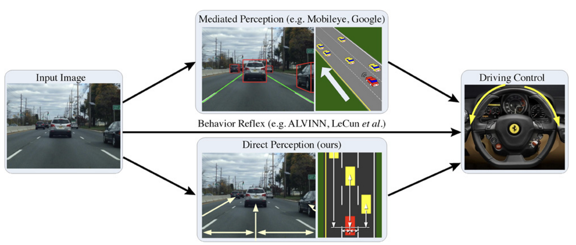
XII-A Mediated Perception Approaches for Autonomous Driving Systems
Mediated perception approaches process the entire scene given by a front-facing camera and parse it in order to recognize driving-relevant objects that impact the driving decisions. This kind of approach depends on independent modules that are used for different specialized recognition tasks, such as lanes, vehicles, pedestrians, traffic lights and signs, free space, etc. [128].
The recognition results of these modules are integrated and combined in a unique world representation to represent the surroundings of the vehicle and from which the final driving decisions are made, as detailed in most of the state-of-the-art systems [129]. The complexity and cost of mediated perception approaches stems from the need to make a total scene parsing and understanding, while only a small number of recognized objects are relevant to make driving decisions from one frame to another.
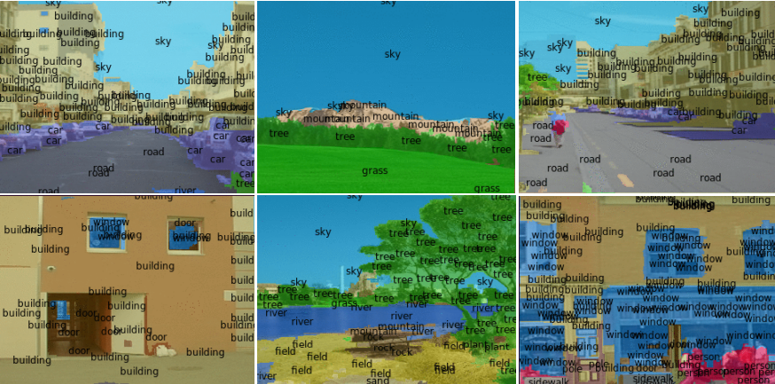
XII-A1 Pixel by Pixel Full Scene Labeling (FSL)
One approach to understand the scene around vehicles is semantic segmentation that labels each pixel in an image with the category of the object to which it belongs. Labeling each pixel of the scene independently from its surrounding pixels is a very hard task to achieve. In order to know the category of a pixel, the labeling process relies on relatively short-range surrounding information and long-range information to understand the context while an object covers more than a pixel. Figure 13 shows the result of FSL on a camera frame from the SIFT flow Dataset.
In other words, to determine that a certain pixel belongs to a vehicle, pedestrian or to any other class of object, FSL needs to have a contextual window that is wide enough to show the surrounding of the pixel and consequently to make an informed decision of the class of the object that contains the pixel. Techniques based on Markov Random Fields (MRF), Conditional Random Field (CRF) and other graphical models are presented in
[130],
[131], [132] to guarantee the consistency of labeling the pixels in the context of the overall image. In addition, the authors in [133], [134] and [135] developed various methods for pre-segmentation into super-pixels or segment candidates that are used to extract the categories and features characterizing individual segments and combinations of neighboring segments.
Farabet et al. [136] developed a FSL technique that includes detection, segmentation and recognition of all objects in the scene. It uses a large contextual window that labels pixels and reduces the requirements for postprocessing methods by using a multiscale Convolutional Neural Network (CNN) that is trained from raw pixels to extract dense feature vectors that are encoding regions of multiple sizes centered on each pixel of the image.
A complete detailed version of the same scene parsing architecture is developed in [137]. The key idea behind the proposed mutiscale dense feature extractor is to generate a series of feature vectors of regions with multiple sizes and centered around every pixel. The CNNs that are fed with raw pixels with end to end training have copies of a single network with the same weights. These networks are applied to multiple scales of a Laplacien pyramid version of the input image. The trained networks offer features that produce efficient multiscale representations for FSL to capture texture, shape and contextual information. Even though the learned multiscale representations allow for the detection and recognition of regions and objects contained in the scene, they do not draw the boundaries of the regions accurately.
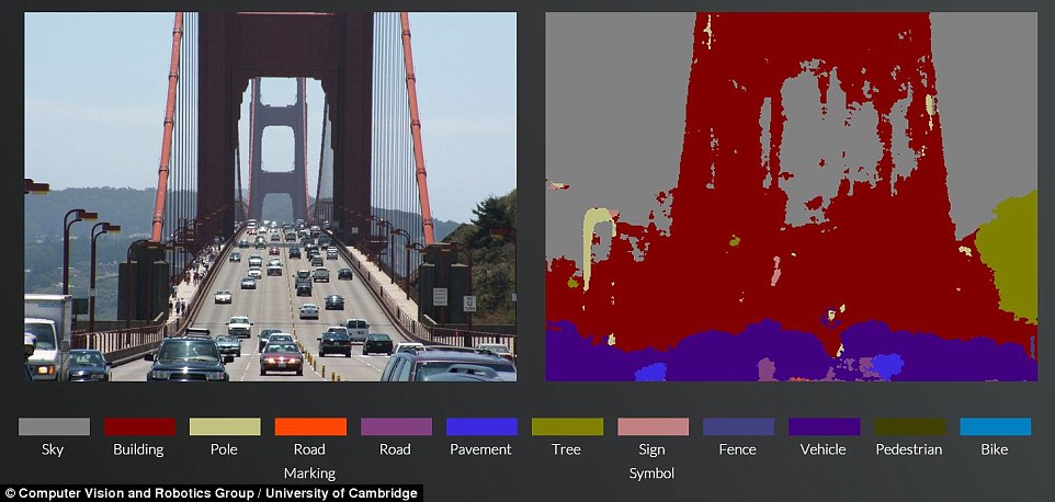
In [138], the authors were the first to utilize the CNN architecture for semantically segmenting the pixel of the images using a pixel-wise classification layer on top of the the decoder network that follows the encoder network. Impressive results of the pixe-lwise classification are presented in Fig. 14.
XII-A2 3D Scene Flow Segmentation
The scene flow is considered as a promising technique in understanding the scene for autonomous vehicles. It offers a flow field describing the 3D motion of interesting objects in the scene by jointly creating their dense geometry and 3D motion from sequences of images. A real-time 3D reconstruction of the scene is eventually achievable by associating every pixel and its exact 3D position with the significant object to which it belongs. It would require solving the open problem of monocular 3D reconstruction of dynamic scenes in order to consider the coherence assumption on surfaces that are truly in the dame space-time proximity.
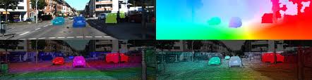
Menze et al. [139] reasoned about decomposing the scene into independently moving indexed objects and using a minimal representation of each one by its rigid motion parameters and each superpixel by a 3D plane. The use of the minimal representation leads to a discrete-continuous CRF and reduces the data into pairwise potentials between superpixels and objects. The 3D location and the 3D flow of each object that delimited by a superpixel in the scene is found by associating every superpixel with a 3D plane variable and a pointer to an object comprising its rigid motion. Then, given consecutive frames of the reference frame, the developed object scene flow infered the 3D geometry of each superpixel, the association to corresponding objects as well as the rigid body motion of each object, as shown in Fig. 15.
While in [140], the authors proposed to segment the input images by representing the dynamic scene as a collection of rigidly moving planes and then jointly recovering the geometry and the 3D motion when over-segmenting the scene. The developed piecewise rigid scene is intended to represent real world scenes with independent object motions rather than pixel-based representations like partially used in [139].
As opposed to the two aforementioned research works that are considered as pure computer vision solutions, the authors in [141] attempt to create 3D reconstruction of dynamic scenes by achieving a long-range spatio-temporal regularization in semantic video segmentation, since both the camera and the scene are in motion. The developed idea is to integrate deep convolutional networks and CRF to perform sharp pixel-level recognition of boundaries of objects. To this end, the solution minimizes the distances between features associated with corresponding points in the scene and consequently optimizes the feature space that is used by the dense CRF.
XII-B Direct Perception Approaches for Autonomous Driving Systems
The direct perception approach was initially introduced by [127] to predict the driving decisions, instead of learning to map images containing different situations with the steering action or parsing and recognizing the scene and deciding the control actions of the vehicle. The developed model is built on top of a CNN that automatically derives indicators of situation of the road, such as the distance between the vehicle and the lane marking, angle of the vehicle relative to the road and distances to other surrounding vehicles. Additionally, the adopted and trained CNN learns to extract image features and makes meaningful predictions and description for scene understanding and autonomously drive the vehicle by the help of a simple controller.
XII-C Behavior Reflex Approaches for Autonomous Driving Systems
Behavior reflex approaches [142] are drastically different from mediated perception approaches and direct perception approaches by constructing a direct mapping of the sensed input to the corresponding driving action that has been taken. One old technique is developed in [143] that generated a neural network to create a direct mapping from input images to corresponding steering angles in order to be directly applied to learn driving actions. To learn the model, the system uses the images and the actions representing the steering angles as the training data. It has been proven that this technique can handle lane navigation, but failed to realize accurate decisions in a complicated traffic scenario.
As opposed to the Autonomous Land Vehicle in a Neural Network (ALVINN) system developed in [142] that uses fully-connected networks, the end-to-end DAVE-2 system proposed by NVIDIA in [144] uses a CNN that directly maps the raw pixels of images from cameras to the steering commands. DAVE-2 makes use of CNNs that offers more than pattern recognition, as it is trained to learn the whole processing pipeline, to find steering decisions based on training video data collected while driving from two cameras and coupled with left and right steering decisions.
XII-D LIDAR Perception Approaches for Autonomous Driving Systems
The work in [145] developed a solution based on LIDAR data only to explore the vehicle surroundings. This solution involves three consecutive phases; namely, segmentation, fragmentation detection and clustering, and tracking. The developed solution is built based on combining multiple artificial intelligence techniques and it is conceived for detecting and tracking objects of any shape that are going to be used by autonomous vehicles to find and understand the scene flow of its surroundings.
XII-E Mixed Mediated and LIDAR Perception Approaches for Autonomous Driving Systems
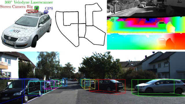
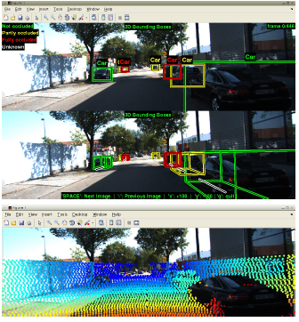
The autonomous driving platform developed in [146] presents an interesting and challenging real-world computer vision benchmarks that include stereo, optical flow, visual odometry, 3D object detection and 3D tracking of real time surroundings of autonomous vehicles. The data includes the LIDAR and the camera recordings of driving sequences.
XIII Localization and Mapping For Self-Driving Vehicles
Traditional localization approaches such as GPS are inaccurate with a significant localization error in addition to the total unreliability because of the insufficient network coverage.
Digital driving instructions have to be ultra-precise since driving requires steering commands to be in consensus with the deep-learning and mapping of the outdoor environment.
Consequently, fully AD systems opt to use high-precision maps or also called HD maps to localize a vehicle in the space and within its surrounding objects in the scene. Automatically created high-precision decision maps put together various enriched multi-model sensed data and a pre-mapped environment that can be from raw LIDAR, Video or mixed sources.
As opposed to standard definition maps that are based on GPS positioning such as Google Maps and used for machine to human communications, HD maps are fundamentally different with a better resolution and are meant for machine-to-machine communications. Its relative localization systems are supposed to provide an approximate maximum localization precision of cm, in comparison with a to meter accuracy in GPS, without the need for external error detection and correction systems.
Major research attempts are discussed in this section to gain a better insight into the real practicality of SLAM [147] for localization of self-driving vehicles through odometry [148] that uses data irrespective of sensing modality to approximate the changes in a vehicle’s position over time.
XIII-A Visual Odometry for Vehicle Localization
Scanned roads by stereo cameras overlaid over high precision positional data produce a highly detailed representation and localization. In this context, Raul et al. developed in [149] a novel feature-based monocular SLAM system that requires creation of initial maps since depths may not be found from a single image frame in order to provide wide baseline loop closing detection and to serve motion clutter. The developed solution covers the tracking, mapping, relocalization and loop closing based on a novel strategy that selects specific key important points and keyframes to generate trackable maps that grow with scene content changes.
Every Map point holds the 3D position of the world coordinate system, the viewing direction consisting of rays joining the point with the optical center of the keyframes observing it, and a representative ORB descriptor holding the smallest hamming distance among all associated descriptors in keyframes where the same point is observed.
In addition, the proposed scheme ensures that every keyframe stores camera principal points and focal length, ORB features that were extracted from the frame independently of whether or not they are associated with map points and the camera pose that represents rigid body transformation of points from real-world coordinates to camera coordinates. Then the co-visibility graph, the essential graph, ORB descriptors extraction and the automatic map initialization are achieved dynamically in order to satisfy finding initial correspondences and making the parallel computation to find inliers between models.
Fig. 19 shows points and keyframe trajectory, ground truth and trajectory and after many iterations of full bundle adjustment.
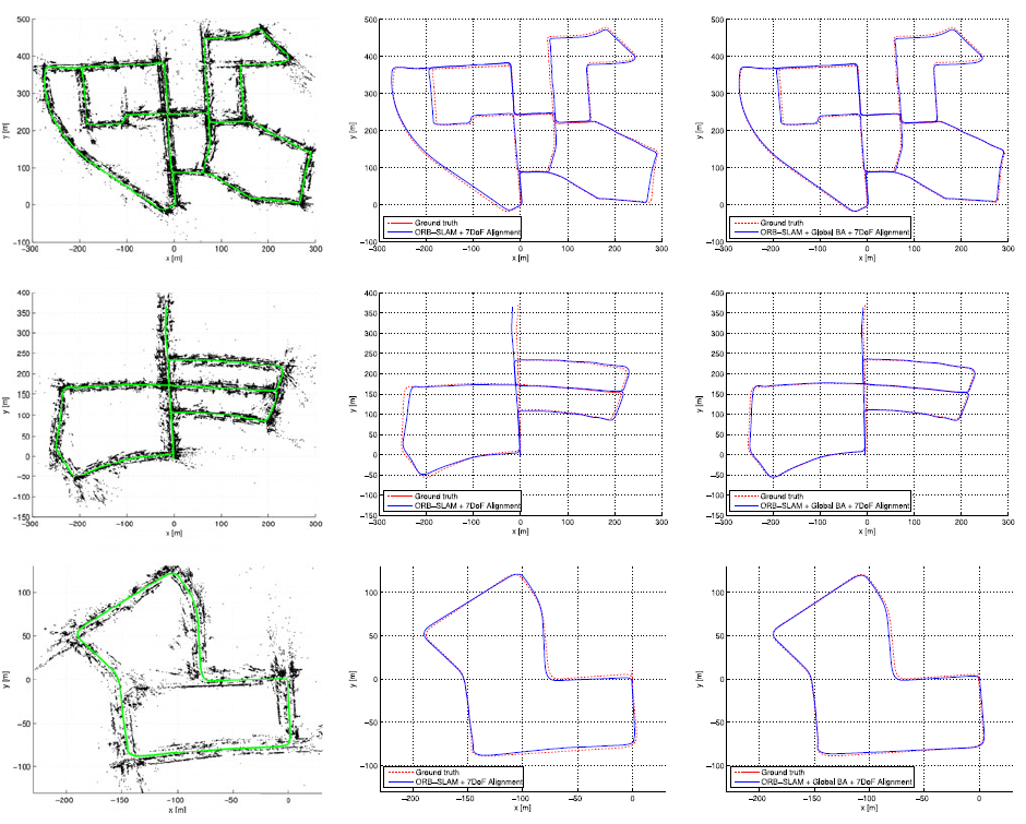
A continuous estimation of vehicle’s current position and orientation depending on the observed environment from the camera is presented in [150]. It enables SLAM with rigidly coupled frames of Multi-Camera Systems (MCS) by taking advantage of the MultiCol Model and introducing:
-
•
The usage of Multi-Key Frames (MKFs) with identification and match points across them and mask outliers.
-
•
Hyper-graph formulation of MultiCol for different tracking and modeling pipeline than used in [149] where graph edges connect two vertexes only and now edges can connect to any arbitrary number of vertexes.
-
•
Advanced Multi-camera loop closing that searches eventual loop closures from newly presented MKF in order to figure out if a place has been visited.
Depiction of the loop closing, applying similarity transformation to possible alignment of points and usage of the alignment error to correct the remaining MKF poses and points mapping by projection to map are generalized in Fig. 20.
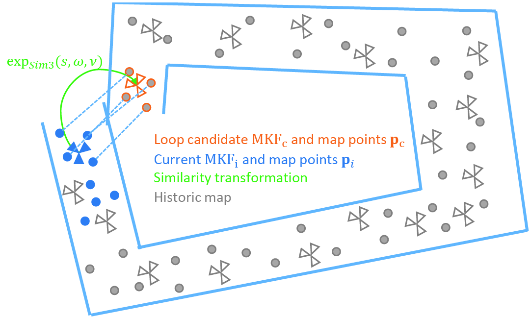
The authors in [151] presented a stereo SLAM localization system called S-PTAM that uses only a stereo camera to avoid the monocular bootstrapping problem as in [149]. To improve robustness, the authors used to enforce stereo constraints on the pose- and map- refinment algorithms and applied a maintenance process for each independent thread by running a map bundle adjustment refinement algorithm in local area to improve global consistency.
Fig. 21 draws the estimated trajectory discovered by S-PTAM compared to ground truth and to generated maps while appiled to the sequence of the KITTI dataset.
To achieve the creation of a reliable visual environment systems, the authors in [152] present a scheme for tracking keypoint and estimation of egomotion and the structure of the environment from the trajectories of the selected keypoints.
Fig. 22 presents an overview of the pipeline of the solution that first consists of decomposing a sequence of images from a monocular camera setup into consecutive frames and applying a propagation based tracking method to find the 2D trajectories of the keypoints and not through finding keypoint correspondences like in [151].
The search of the keypoints matches from one frame is achieved by propagating the estimated 3D position of each keypoint from one frame to another and by making sure that the photometric consistency is verified.
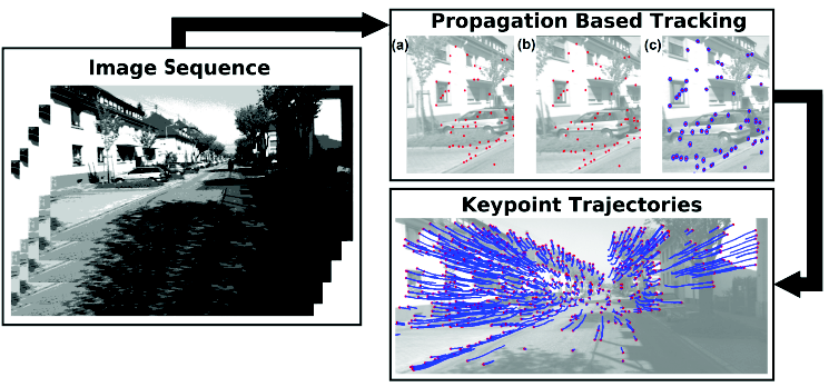
XIII-B LIDAR-Based Vehicle Localization
In general, the rotational movement of LIDAR scanners and having the vehicle on the move too, make the registration and localization of the point cloud very difficult.
The authors in [153] proposed a solution that uses odometry measurements to achieve low-drift and low-computational complexity by applying two algorithms. The first algorithm is applied to perform the odometry with low fidelity and high frequency for LIDAR velocity estimation. The second algorithm is applied to run with a lower frequency to perform both fine matching and registration of the point cloud data.
The LIDAR odometry algorithm uses last sweep point cloud, current sweep growing point cloud and the pose transform from last recursion as inputs parameters. It extracts feature points, finds its correspondence and applies motion estimation to a robust fitting. The mapping algorithm is used to match and register the reprojected point cloud to a specific time stamp, based on the undistorted point cloud and the pose transform that contains the LIDAR motion during the sweep generated by the LIDAR odometry algorithm. LOAM solution is ranked #3, with a 0.70 % , on the KITTI odometry benchmark for the average computed translational and rotational errors.
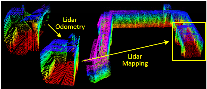
The authors in [154] developed a novel idea of synthetic 2D LIDAR in order to achieve precise vehicle localization on a virtual 2D plane. The presented Monte Carlo Localization to estiamte the position of the vehicle replies on the synthetic LIDAR measurements and odometry information. A demonstration of the accuracy and robustness of this approach is demonstrated through carrying out real-time localization of the driving test in the NUS campus area.
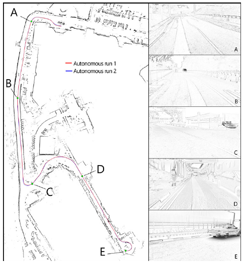
In [155], the authors studied an accurate and reliable vehicle localization system by using the landmarks acquired from LIDAR mapping systems. Since the standard Global Navigation Satellite System (GNSS) solutions lacks high reliability, the developed solution relies on relative localization using LIDAR sensors and a pre-mapped environment. Consequently, the creation of detailed environment maps is a necessary step to produce accurate localization. The obtained landmark pairs are then associated with each others using an estimation approach, which leads to accurate position estimations of the robotic vehicle.
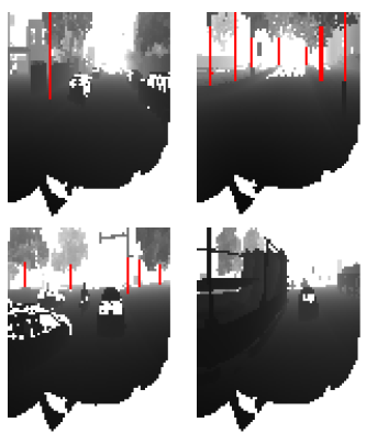
Additionally, more advanced methods were incorporated, such as using dead reckoning based on multiple matching successive scans as presented in SLAM approaches. Alternatively, the authors discussed other landmark incorporating examples like planar patches. Then, they investigated in details the matching algorithm with the RMS variations, and the weak configuration points that were automatically detected. This yield smaller error bounds that met the requirement of the design in terms of reliable and automatic association procedure.
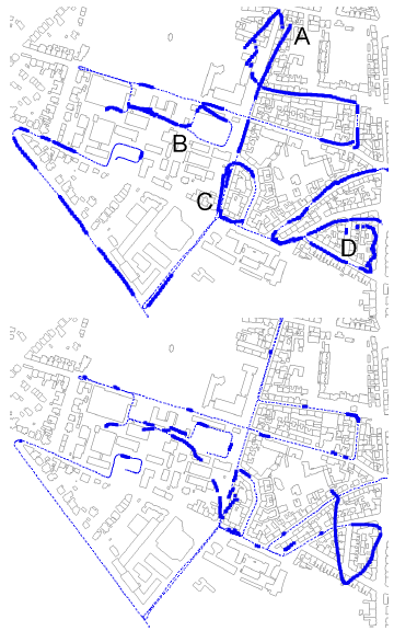
XIII-C Combined Visual-LIDAR Odometry for Vehicle Localization
It is widely used to utilize the dense point clouds with measures of surface reflectivity obtained by LIDAR scans to obtain localization results of centimeter-level accuracy. However, this comes at a prohibitive cost in terms of sensor suites and complex state-of-the-art localization techniques. This is why, the authors in [156] investigated a cheaper model that finds comparable localization accuracy using cameras.
The developed model is built to localize a single monocular camera within an already created 3D ground map from a surveying vehicle equipped with 3D LIDAR scanners. To realize that, a GPU is used to create several synthetic views of the visited environment in order to achieve maximal normalized mutual information between the GPU and the real camera measures.
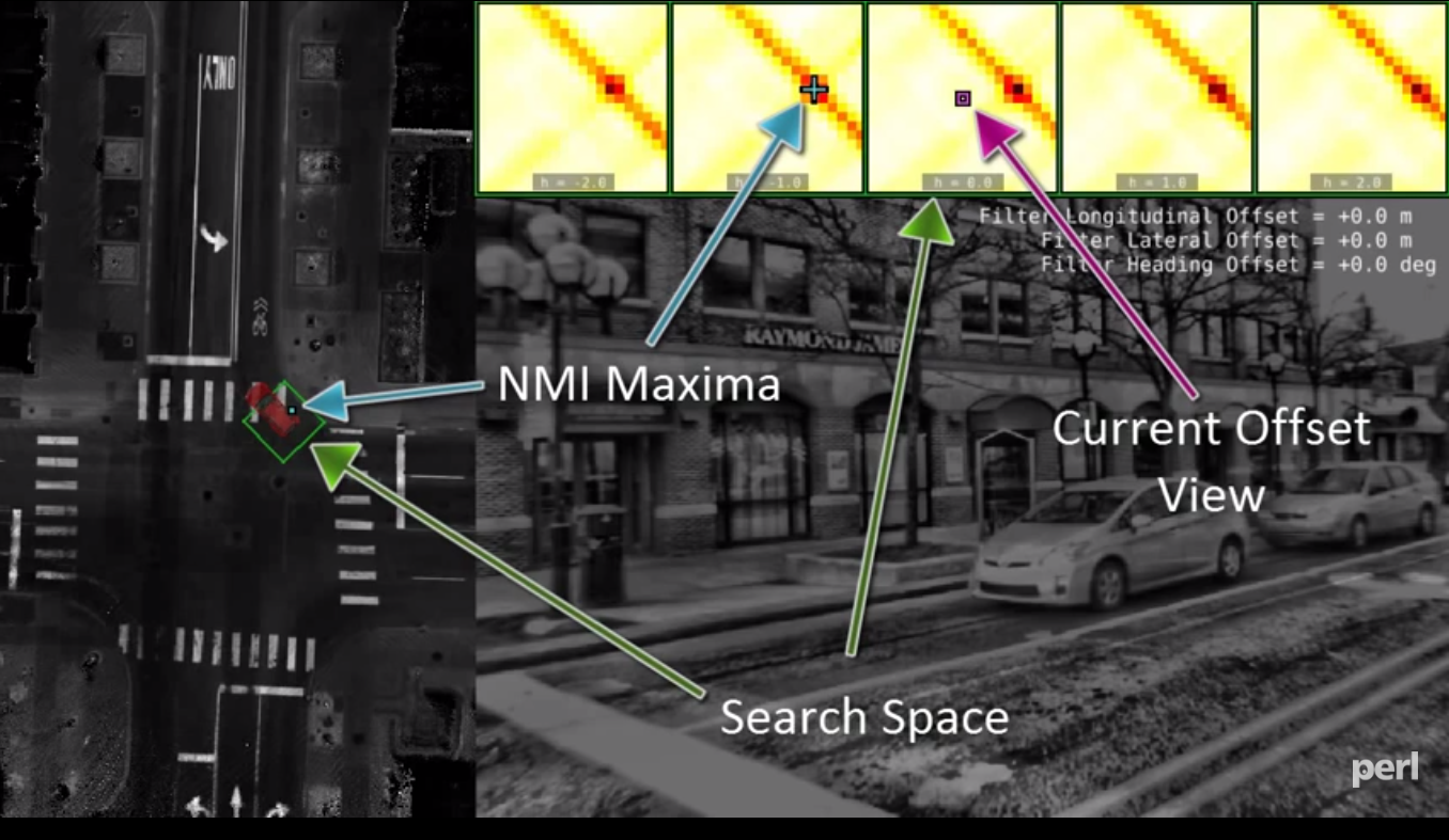
In [157], the authors present a general framework for combining visual and LIDAR odometries in a fundamental and novel method. The method shows improvements in performance over the state of the art, particularly in robustness to aggressive motion and temporary lack of visual features. The proposed on-line method starts with a visual odometry to estimate the ego-motion and to register point clouds from a scanning LIDAR at a high frequency but low fidelity. Then, scan matching based LIDAR odometry refines the motion estimation and point cloud registration, simultaneously. In addition to the comparison of the motion estimation accuracy, the authors evaluated the robustness of the method when the sensor suite moves at a high speed and is subject to significant ambient lighting changes.
The overall system is divided into two sections. The visual odometry section estimates frame to frame motion of the sensor at the image frame rate, using visual images with assistance from LIDAR clouds. In this section, the feature tracking block extracts and matches visual features between consecutive images.
The depth map registration block registers LIDAR clouds on a local depthmap, and associates depth to the visual features. The frame to frame motion estimation block takes the visual features to compute motion estimates.
When applied to the KITTI odometry benchmark for assessing the translational and rotational errors, V-LOAM achieves 0.75% of relative position drift and is ranked #2.
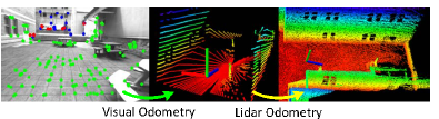
Visual odometry can be augmented with depth information as provided by RGB-D cameras, or from LIDARs associated with cameras. However, such depth information can be limited by the sensors, leaving large areas in the visual images where depth is unavailable.
The authors [158] propose a method to utilize the depth, even if sparsely available, in recovery of camera motion. In addition, the method utilizes depth by triangulation from the previously estimated motion, and salient visual features for which depth is unavailable. The core of the proposed method is a bundle adjustment that refines the motion estimates in parallel by processing a sequence of images, in a batch optimization.
The method in [158] for the three sensor setups, one using an RGB-D camera, and two using combinations of a camera and a 3D LIDAR. The presented method is rated #2 on the KITTI odometry benchmark irrespective of the sensing modality, and is rated #1 among visual odometry methods.
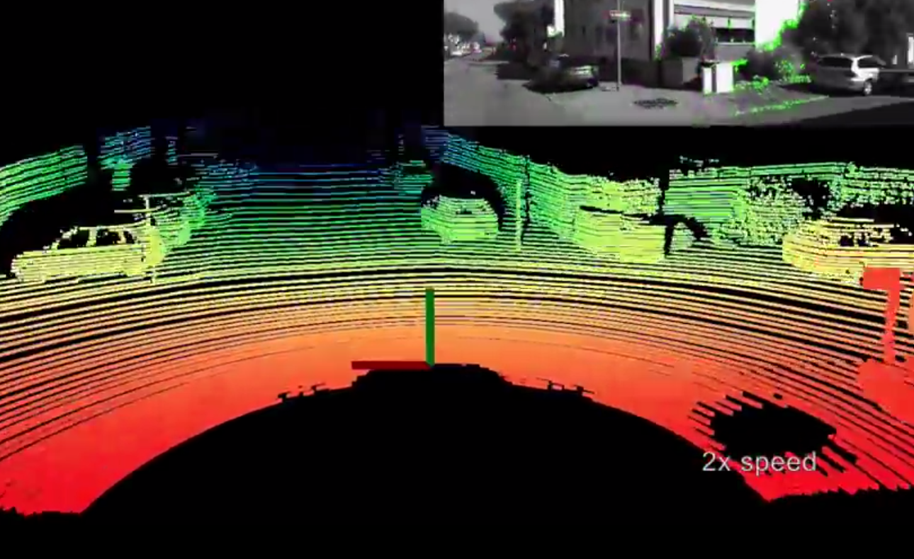
In [159] the authors developed a complete solution for high-accuracy localization of vehicles on the move using urban environments’ maps. The presented solution aims to generate high-resolution environment maps by integrating GPS, IMU, wheel odometry, and LIDAR point cloud data obtained from the vehicle’s recorded data. The solution allows the localization of the moving vehicle within the maps by mainly using a particle filter method for calculating the correlation of LIDAR measurements with the map.
The map is created by the reconstruction the 3D structure of the environment using infrared reflected laser beams of the LIDAR. More precisely, the experimental results relative accuracy are better by more than an order of magnitude than the ones using traditional methods (e.g., GPS, IMU and odometry). Concretely, the presented solution achieved a reliable real-time localization within centimeter range accuracy during bad whether and without GPS services, as opposed to the non accurate outdoor localization research work based only on GPS.
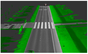
PART 4: TOWARDS VCs MEETING AUTONOMOUS VEHICLES
In full alignment with the USDoT’s ITS-JPO vision stated in the RFP, we innovatively blend connected vehicle technology with autonomous vehicle systems. These systems will leverage the power of V2V and V2I communications, to significantly enrich the vehicle understanding of its surroundings and collectively perform driving decisions given the exchanged dynamics, movements, and intents of all vehicles.
In addition to the communications impact, VCs are expected to play a major role in supporting the limited capabilities of vehicles with on the move add-on functionalities. The VC will contribute to creating solid learning formulations to build more accurate 3D scenes of the vehicle surroundings, using the acquired information from multiple input modes, such as cameras, LIDARs, and exchanged V2V/V2I messages.
The targeted multimodal solutions will insert all the information acquired by the input modes into one mapping and learning setting, which is very likely to be the revolutionary HD live maps. It encodes one accurate 3D space representing the surrounding scene including V2V-enabled out-of-sight vehicles and V2I-conveyed sign/signal information, 2D images with rich texture description and accurate object depth in 3D LIDAR point clouds.
XIV Post Alignment and Fusion
Maalej et al. presented in [160] a multimodal framework for object detection, recognition and mapping based on the fusion of stereo camera frames, point cloud Velodyne LIDAR scans, and V2V exchanged BSMs over DSRC. Based on the adapted Darknet’s CNN, the pixel-wise adjacency coordinates of moments are derived from the bounding boxes of recognized objects of KITTI frames. In addition, objects are retrieved from point cloud scans to the same camera capture. The generated BSMs corresponding to the vehicles from LIDAR have position (x,y,z) triplet as a replacement to the real-world positioning from (Latitude, Longitude, Elevation). The authors presented a semi-supervised manifold alignment technique to achieve camera-LIDAR and camera-V2V mapping of recognized objects that have the same underlying manifold.
The post-alignement consists of matching correpsonding pairs of recognized objects to reconstruct a 3D world as a virtual map surrounding the self-driving vehicles. Finally, the presented enriched points are the ones that were not mapped as they might correspond to out-of-sight objects, or BSMs of distant cars, etc.
Alternatively in [161], the idea of a cloud-to-car mapping system is presented by Archer Software to have from the cloud the most updated details about road networks like lane curvature, roadway profile, static positions of traffic signs and then recognized objects from the car itself are post-added in order to achieve automatic maneuvering.
In [162], the authors present a novel cloud-assisted design for autonomous driving that is called Carcel, where all the sensed data from self-driving cars and from static roadside sensors are post-aggregated and managed in the cloud. Precisely, the cloud is responsible for conveying obstacles to vehicles after analyzing the received information, which means that the cloud will assist vehicles on roads to make decisions to avoid obstacles that are not necessarily sensed by their sensors. Moreover, the longer range information that the cloud builds about the traffic patterns enables more efficient path planning. This method is not realistic due to the huge amount of data that is sent from and to the cloud, which delays the steering decisions arriving to vehicles.
XV Pre-fusion between VC and AD Data Modalities
As opposed to the post-fusion and mapping systems, the pre-fusion systems do not rely on having seperate recognized data from sensors or cloud that are mapped together. For example, Mobileye’s REM system [163] relies first on a pre-existing rich HD maps that are supplemented with to-the-minute data from real-world driving. An advanced faster version for accurate real-time mapping of data is currently under development.
An issue with the pre-fusion of cloud data of in-vehicle sensors is the threat of cyber attacks which may lead to a disastrous reconstruction of surrounding world and consequently to a failing AD system. As detailed in [164] having self-driving vehicles relying on offline system might be the solution to hinder hackers.
More simplistic and secure scheme that does not rely on incoming cloud data is developed in [165], where a Multi-View 3D networks (MV3D) is developed to guarantee accurate 3D object detection applied to autonomous driving scenarios. The developed sensory-fusion framework is used to predict the orientation of 3D bounding boxes representing an object by taking both raw RGB images and LIDAR point cloud without applying any prior recognition. The generated candidates of 3D boxes for localization and detection in the KITTI benchmark outperforms the up-to-date systems by approximately 25% and 30%.
Similarly in [166], the 3D point cloud and 2D front view images are fused via a CNN with the usage of a Region Proposal Network (RPN) that is used in the network’s multiple layers to generate proposal region objects in the front view.
XVI Cooperative and Coordinated Autonomous Driving
In order to fully leverage the autonomy of self-driving vehicles, it is obvious that developing intelligent systems built on top of coordinated autonomy would guarantee additional safety with more trusted manoeuvres, reduce fuel consumption and balanced network traffic while guaranteeing a cooperative dispatching of vehicles depending on time and positions. In this context many ongoing research projects on vehicles coordination are being developed.
EPFL’s research team working on the AutoNet2030 [167] presented in the design of distributed algorithms among vehicles with different levels of intelligence on borad ranging from fully autonomous to standard vehicles for cooperation among vehicles. The demonstration included an autonomous truck, an autonomous vehicle and an ordinary car equipped with a human machine interface that was able to satisfy cooperatively a merging scenario on a highway by offering enough space to a vehicles intending to merge between the two others. The robustness of the algorithms allows its deployability even before having all the vehicles being autonomous.
Another key feature of coordinated driving is being implemented by the authors in [168] consisting of a decentralized trajectory coordination for autonomous vehicles without the usage of widely applied synchronization points that force all vehicles to pass by synchronously. The developed system assumes that a unique priority is assigned to every vehicle and each one periodically informs other vehicles about its planned future trajectory through V2V communications. Consequently, every vehicle will be responsible for maintaining the possible trajectory that will be collision-free with regard to other vehicles with higher priority. The collision-free path is obtained by the trajectory planned that takes into account space, time and a pre-designed network of paths while modeling higher-priority vehicles when moving. A real time scenario validating the developed method is presented where every conflict between desired trajectories triggers automatic conflict resolution.
XVII Examples of Integration Systems
NVIDIA’s Drive PX [169] AI car computer for self-driving vehicles is considered as a pioneering effort among all the computing platforms for real-time scene understanding, HD mapping, energy efficiency, automated highway driving, accelerated deep learning, sensor fusion, HD mapping, etc. Its GPU data parallel architecture accelerates the perception task of detecting and classifying objects using deep neural networks that are pre-trained in cloud datacenters and deployed in the vehicle.
In addition NVIDIA’s recently developed Co-Pilot [170] is considered as an extra AI system built toward fully autonomous systems that is either driving the vehicle or looking out for the driver. In other words, for tricky traffic, changing roads without up-to date maps or highly fuzzy uncertain perception then the Co-Pilot makes sure to increase passenger driver awareness with surrounding environmental awareness. It notifies the driver about objects that she might need to be concerned about, increase the cautiousness of driver about where to look by focusing on the driver’s face recognition, head tracking, gaze tracking, lips reading, etc.
NVIDIA’s DriveWorks [171] is a powerful Software Development Kit (SDK) for researchers and industry to implement any level of autonomous driving accelerated on Drive PX. Its layered architecture and run-time pipeline framework is detailed in Fig. 31 and offers the following:
-
•
Detection Libraries used for various types of sensors processing, fusion for objects segmentation, detection and classification.
-
•
Localization Libraries used for odometry mapping, map localization and HD maps interfacing.
-
•
Planning Libraries to ensure functions of vehicle automatic control, overall scene understanding and intelligent path planning.
-
•
Visualization Libraries offering applications for cluster display streaming, ADAS and debug rendering.
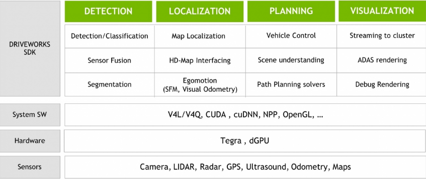
Partnering with NVIDIA on AI technology, HERE [172] is moving forward to accelerate its HD Live Maps [173] by using DRIVE PX 2 for its self-driving vehicle solutions that are delivered as a cloud service for a digital mapping content. The HD Live Maps is a layered complex solution, visualized in Fig. 32, can be depicted as:
-
•
Lane Model: is considered as the key model of the HD maps since it provides a highly accurate representation of the road networks with different lanes’ separation and roads’ delimiters, all mapper with a 10 to 20 cm precision.
-
•
Localization Model: allows finding the exact position of the vehicle in the lane where it is driving on the HD Map. Interestingly, it allows cars to be map makers since as long as they are being on the road, they collect data about the perceived environment and provide it to the cloud which aggregates all received information to update the maps.
-
•
Activity Layer: plays a major role in understanding dynamic events while driving on the road network such as heavy traffic, accidents, road closures, and other dynamic events that may impact the driving strategies and paths of the vehicle.
-
•
Analytic Layer is used to adapt to tricky scenarios on how to drive by looking at various driving styles that inform the vehicles on how to behave under similar conditions.
As an illustration, HERE HD Live Maps offer intelligent complete solutions needed to pave the road to raise the trust in the commercial sustainability and reusability of automated driving systems by vehicle manufacturers for automated driving solutions.
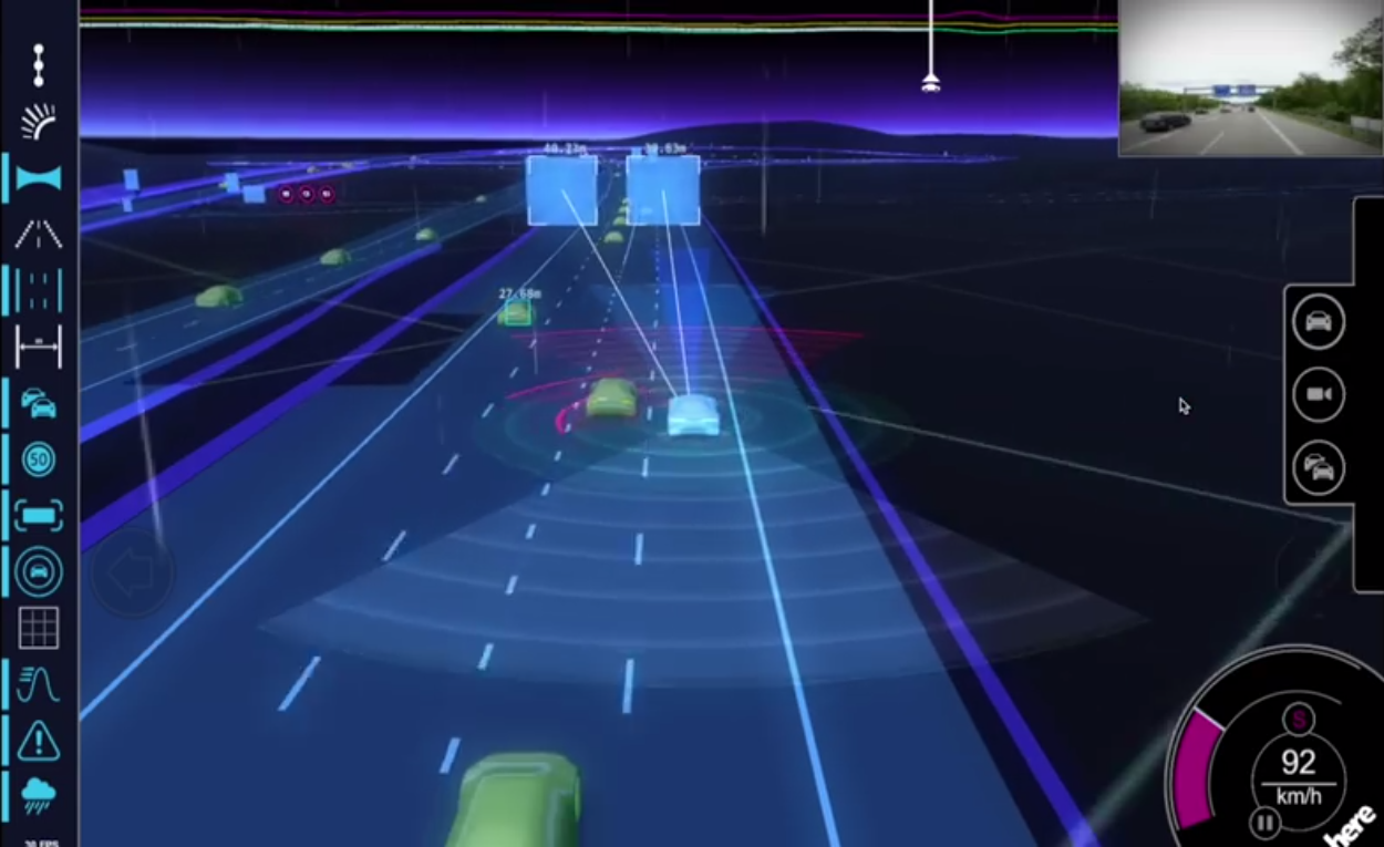
With cameras, RADAR, LIDAR, unreliable GPS and more sensors, Waymo [174] as formerly known as the Google self-driving car has achieved self-driven 3 million miles by using complex heavy computation mapping and fusion of sensed data while using minimal access to cloud-based services. Up to now, the self-driving is not commercialized yet even though there have been different prototypes varying from modified traditional vehicles requiring human inputs to vehicles without steering wheels.
Tesla’s Autopilot [175] is considered as the most popular full standalone hardware with software solution for autonomous cars that is being actively updated and refined as long as the number of driven miles get higher, more than 1.3 billion miles of data [176]. All cars built by Tesla after 2014 are equipped with hardware autopilot that are capable of receiving updates from the cloud of the core software for self-driving, required drivers for the sensors, etc.
With its particular technology that relies on 8 cameras, surrounding both Model S and X, along with twelve ultrasonic sensors, RADAR and GPS, the Autopilot creates a 3D view of the vehicle’s surrounding in every direction that is beyond human access. The enhanced Autopilot offers new capabilities varying from simple speed to traffic condition adjustment to complex lane changing without driver’s input.
Despite these new technological advancements and market solutions for autonomous driving, most of the aforementioned solutions have at certain places, moments or situations low confidence of driving autonomously. With such low confidence, self-driving systems require the driver to take-over the commands for driving.
PART 5: OPEN CHALLENGES AND CONCLUSION
In this part, we analyze the challenges and future trends that need to be solved before having a wide popularity of infotainment applications over VC and safety services in VANETs. Equally important, the full transition from advanced driver assisting to autonomous systems requires many technologies ranging from HD maps to fail-proof software to be more mature and reliable before such vehicles hit the roads.
XVIII Open Challenges
The lack of a widely used and standardized wireless communications technology in VANETs is one the most challenging problems blocking the expansion of VCs. Existing state-of-the-art research on communications would satisfy the safety aspect required for V2V safety systems, but does not meet the need of the autonomous driving connectivity.
5G might be the complete communications technology that will ease transforming VCs and automation systems from a vision into a widely reasonably affordable reality. Consequently, the challenges facing 5G connections float on the surface as a disruptive factor for VCs exploitation. Similarly, knowing that self-driving vehicles are making Big Data even bigger, high speed connectivity like 5G would be the solution to tap into faster networks and to offload to the cloud the several hundreds of mega bits created per second.
The security issues in both the communications and the automation systems would be definitely areas of study of the standardized complete systems when developed. Additionally, sooner or later VCs are supposed to manage the microdatacenters mounted in vehicles, communications base stations and the traditional VC architectures in the hope that they will revolutionize various systems to be taken advantage of in modern vehicles.
The existing low level vehicles’ automation has not led to fully self-driving complete systems yet. This is due to the many open unsolved problems or existing solutions that need more refinements and improvements.
To put it another way, it is obvious that owning the most intelligent accurate HD maps will certainly own the future of self-driving vehicles, independently of the perception, planning and command technologies. That is the virtual-world map of streets, which allow the vehicles to accurately map themselves as if they are on well-known empty streets and add detected dynamic objects later.
Moreover, new sophisticated and cheaper sensors should be developed to make the business model of self-driving vhicles more attractive. For example, the spinning Velodyne LIDAR offers great 360 degrees visibility and accurate depth information, but comes at a high price tag and huge amount of created data that makes processing so complex.
Recently announced solid state LIDARs by Quanergy [177] and Velodyne [178] are expected to hit the market with few hundred US dollars in comparison to several thousand US dollars for the spinning LIDARs.
Some problems facing Spinning-LIDARs along with a comparison with solid state LIDAR are presented in [179] including durability, precision, stability, etc. Fail-safe real-time software used as components in the autonomous driving systems are far from being completely developed and validated. These pieces of software may include failing functionalities for:
-
•
objects detection, classification and tracking.
-
•
sensors fusion and vehicle mapping.
-
•
deep scene understanding and path planning.
-
•
control and steering systems.
XIX Conclusion
Self-driving vehicles are known as the mother of artificial intelligence systems and the one with most promising business models. The emerging idea of VC is very promising too, aiming to improve the driving experience by using various types of infotainment applications, and to increase the vehicles safety by using beaconing applications and supporting extra additional over the air data for self-driving systems.
Moreover, many challenges and issues related to the vehicular cloud and vehicular network management especially with the fast changing topology have been presented. Key challenges to enable VC and AD systems to be coherent and reinforce the desired functionalites either related to the driving commands or the driving experience are also presented. We studied the various complex components that need to be built, integrated and fit together to guarantee an autonomous driving vehicle. The sensing, perception, decision and actuation layers come with many challenges to be deployed, tested and then put into real-world systems. The challenges that involved in these layers are presented in this paper.
We also presented an overview of the existing communication technologies, VANET MAC protocols, algorithms for VANET network coalition, reliability of safety and non-safety applications, Vehicular cloud selection based on cost and QoS, all used to bridge reliable communications, VC and AD systems.
List OF Acronyms
-
IOV
Internet of Vehicles
-
VC
Vehicular Cloud
-
VCC
Vehicular Cloud Computing
-
AD
Autonomous Driving
-
AI
Artificial Intelligence
-
V2V
Vehicle-to-Vehicle
-
V2I
Vehicle-to-Infrastructure
-
VANETs
vehicular ad-hoc networks
-
NSF
National Science Foundation
-
USDoT
US Department of Transportation
-
OBU
Onboard unit
-
DSRC
Dedicated Short Range Communication
-
LTE
Long Term Evolution
-
WAVE
Wireless Access for Vehicular Environment
-
CCH
Control Channel
-
SCH
Service Channel
-
MAC
Media Access Control
-
SLAM
Simultaneous localization and mapping
-
BSM
Basic Safety Message
-
NPRM
Notice of Proposed Rule-Making
-
NHTSA
National Highway Traffic Safety Administration
-
SI
Synchronization Interval
-
QoS
Quality of Service
-
FCC
Federal Communication Commission
-
AC
Access Categorie
-
WSM
WAVE Short Message
-
PHY
Physical Layer
-
CCHI
Control Channel Interval
-
SCHI
Service Channel Interval
-
V2X
Vehicle to Any
-
CAM
Cooperative Awareness Messages
-
MBMS
Multimedia Broadcast and Multicast Services
-
eMBMS
evolved MBMS
-
MANETs
mobile ad hoc networks
-
TDMA
Time Division Multiple Access
-
FDMA
Frequency Division Multiple Access
-
CDMA
Code Division Multiple Access
-
POA
Point of Attachment
-
VHO
Vertical Handoff
-
AODV
Ad-hoc On Demand Distance Vector
-
DSDV
Destination-Sequenced Distance-Vector
-
DSR
Dynamic Source Routing
-
GPSR
Greedy Perimeter Stateless Routing
-
GPCR
Greedy Perimeter Coordinator Routing
-
GeoDTN
Geographic Delay Tolerant Network Navigation
-
+Nav
with navigation
-
STAR
Street and Traffic Aware Routing
-
A-STAR
Anchor-based STAR
-
IEGRP
Infrastructure Enhanced Geographic Routing Protocol
-
T-TSG
Time Stable Geocast
-
PREQ
Propagation of Request
-
GeoSPIN
Geocast Spatial Information
-
IVG
Inter-Vehicles Geocast
-
RTS
Request To Send
-
CTS
Clear To Send
-
ACK
Acknowledgement
-
SSVW
Stop Sign Violation Warning
-
RCVW
Railroad Crossing Violation Warning
-
SWIW
Spot Weather Information Warning
-
OVW
Oversize Vehicle Warning
-
RSZW
Reduced Speed Zone Warning
-
FCW
Forward Collision Warning
-
LTA
Left Turn Assist
-
IMA
Intersection Movement Assist
-
BSW
Blind Spot Warning
-
LCW
Lane Change Warning
-
RSS
Received Signal Strength
-
BEC
Back-End Cloud
-
INS
Inertial Navigation Sensors
-
VM
Virtual Machine
-
MDP
Markov Decision Process
-
CC
Cloud Controller
-
WRI
Wireless Roadside Inspection
-
ISP
Internet Service Provider
-
CSP
Cloud Service Provider
-
VCSP
Vehicular Cloud Service Provider
-
MCC
Mobile CLoud Computing
-
CDAR
Cloud Directory Application Repository
-
DOS
Denial of Service
-
NaaS
Network as a Service
-
STaaS
Storage as a Service
-
CaaS
Cooperation as a Service
-
INaaS
Information as a Service
-
SaaS
Software as a Service
-
PaaS
Platform as a Service
-
FSL
Full Scene Labeling
-
MRF
Markov Random Fields
-
CRF
Conditional Random Field
-
CNN
Convolutional Neural Network
-
ALVINN
Autonomous Land Vehicle in a Neural Network
-
GPS
Global Positioning System
-
MCS
multi-camera systems
-
MKFs
Multi-Keyframes
-
GNSS
Global Navigation Satellite System
-
MV3D
MultiView 3D networks
-
RPN
Region Proposal Network
-
SDK
Software Development Kit
References
- [1] I. Sima, “Iot and smart cars: Changing the world for the better.” http://www.digitalistmag.com/iot/2016/08/30/iot-smart-connected-cars-will-change-world-04422640. Published August 30, 2016.
- [2] T. T. Team, “A tragic loss.” https://www.tesla.com/blog/tragic-loss. Published June 30, 2016.
- [3] R. Grenoble, “Self-driving uber blows through red light on first day in san francisco.” http://www.huffingtonpost.com/entry/self-driving-uber-san-fran-red-light-video_us_5851c9c5e4b0732b82fedb01. Published December 14, 2016.
- [4] M. Essery, “Self-driving cars an $87 billion opportunity in 2030, though none reach full autonomy.” http://www.luxresearchinc.com/news-and-events/press-releases/read/self-driving-cars-87-billion-opportunity-2030-though-none-reach.
- [5] S. Abuelsamid, “New cars could be required to ’talk’ to each other as soon as 2020.” https://www.forbes.com/sites/samabuelsamid/2016/12/13/nhtsa-finally-issues-draft\\-v2v-communications-rule-could-be-mandatory-from-2021/#696da21f7581. Published December 13, 2016.
- [6] S. Abuelsamid, “Toyota and university of michigan to expand world’s largest real-world v2x communications test.” www.forbes.com/sites/samabuelsamid/2016/04/13/toyota-and-university-of-michigan-to-expand-worlds-largest-real.
- [7] “Global connected car market (technology, connectivity solutions, product and services, applications and geography)-size, share, global trends, company profiles, demand, insights, analysis, research, report, opportunities, segmentation and forecast, 2013.” www.marketresearchreports.com/allied-market-research/global-connected-car-market-technology-connectivity-solutions.
- [8] D. Jiang, V. Taliwal, A. Meier, W. Holfelder, and R. Herrtwich, “Design of 5.9 ghz dsrc-based vehicular safety communication,” IEEE Wireless Communications, vol. 13, pp. 36–43, October 2006.
- [9] “Federal communications commission, fcc report and order std,” IEEE Wireless Communication, pp. FCC 99–305, October 1999.
- [10] M.Shulman and R.Deering, “Vehicle safety communications in the united states,” United States Department of Transportation, pp. Rep. 07–0010, 2006.
- [11] Y. Maalej, A. Abderrahim, M. Guizani, B. Hamdaoui, and E. Balti, “Advanced activity-aware multi-channel operations1609.4 in vanets for vehicular clouds,” in 2016 IEEE Global Communications Conference (GLOBECOM), pp. 1–6, Dec 2016.
- [12] “Ieee draft guide for wireless access in vehicular environments (wave) - architecture,” IEEE P1609.0/D5, September 2012, pp. 1–74, Oct 2012.
- [13] Q. Chen, D. Jiang, and L. Delgrossi, “Ieee 1609.4 dsrc multi-channel operations and its implications on vehicle safety communications,” in 2009 IEEE Vehicular Networking Conference (VNC), pp. 1–8, Oct 2009.
- [14] K. A. Hafeez, A. Anpalagan, and L. Zhao, “Optimizing the control channel interval of the dsrc for vehicular safety applications,” IEEE Transactions on Vehicular Technology, vol. 65, pp. 3377–3388, May 2016.
- [15] T. Mangel, Inter-Vehicle Communication at Intersections : An Evaluation of Ad-Hoc and Cellular Communication. KIT Scientific Publ., 2014.
- [16] T. Mangel, T. Kosch, and H. Hartenstein, “A comparison of umts and lte for vehicular safety communication at intersections,” in Vehicular Networking Conference (VNC), 2010 IEEE, pp. 293–300, Dec 2010.
- [17] J. Calabuig, J. F. Monserrat, D. Gozalvez, and O. Klemp, “Safety on the roads: Lte alternatives for sending its messages,” IEEE Vehicular Technology Magazine, vol. 9, pp. 61–70, Dec 2014.
- [18] G. Araniti, C. Campolo, M. Condoluci, A. Iera, and A. Molinaro, “Lte for vehicular networking: a survey,” IEEE Communications Magazine, vol. 51, pp. 148–157, May 2013.
- [19] “Multimedia broadcast/multicast service (mbms); architecture and functional description (release 13),” Third Generation Partnership Project (3GPP), Technical Specification Group Services and System Aspects (TSG SA), vol. 3GPP TS 23.246 V13.0.0.
- [20] K. Abboud, H. Omar, and W. Zhuang, “Interworking of dsrc and cellular network technologies for v2x communications: A survey,” IEEE Transactions on Vehicular Technology, vol. PP, no. 99, pp. 1–1, 2016.
- [21] C. W. Sung and K. W. Shum, “Channel assignment and layer selection in hierarchical cellular system with fuzzy control,” IEEE Transactions on Vehicular Technology, vol. 50, pp. 657–663, May 2001.
- [22] G. Boggia, P. Camarda, and N. D. Fonzo, “Teletraffic analysis of hierarchical cellular communication networks,” IEEE Transactions on Vehicular Technology, vol. 52, pp. 931–946, July 2003.
- [23] H. Zhang, F. Bai, and X. Ju, “Heterogeneous vehicular wireless networking: A theoretical perspective,” in 2015 IEEE Wireless Communications and Networking Conference (WCNC), pp. 1936–1941, March 2015.
- [24] S. Bi, C. Chen, R. Du, and X. Guan, “Proper handover between vanet and cellular network improves internet access,” in 2014 IEEE 80th Vehicular Technology Conference (VTC2014-Fall), pp. 1–5, Sept 2014.
- [25] I. Lequerica, P. M. Ruiz, and V. Cabrera, “Improvement of vehicular communications by using 3g capabilities to disseminate control information,” IEEE Network, vol. 24, pp. 32–38, Jan 2010.
- [26] I. Ku, Y. Lu, M. Gerla, R. L. Gomes, F. Ongaro, and E. Cerqueira, “Towards software-defined vanet: Architecture and services,” in Ad Hoc Networking Workshop (MED-HOC-NET), 2014 13th Annual Mediterranean, pp. 103–110, June 2014.
- [27] E. Yaacoub, F. Filali, and A. Abu-Dayya, “Qoe enhancement of svc video streaming over vehicular networks using cooperative lte/802.11p communications,” IEEE Journal of Selected Topics in Signal Processing, vol. 9, pp. 37–49, Feb 2015.
- [28] A. Benslimane, T. Taleb, and R. Sivaraj, “Dynamic clustering-based adaptive mobile gateway management in integrated vanet - 3g heterogeneous wireless networks,” IEEE Journal on Selected Areas in Communications, vol. 29, pp. 559–570, March 2011.
- [29] B. Liu, D. Jia, J. Wang, K. Lu, and L. Wu, “Cloud-assisted safety message dissemination in vanet-cellular heterogeneous wireless network,” IEEE Systems Journal, vol. PP, no. 99, pp. 1–12, 2015.
- [30] F. Li and Y. Wang, “Routing in vehicular ad hoc networks: A survey,” IEEE Vehicular Technology Magazine, vol. 2, pp. 12–22, June 2007.
- [31] J. Chen, B. Liu, L. Gui, F. Sun, and H. Zhou, “Engineering link utilization in cellular offloading oriented vanets,” in 2015 IEEE Global Communications Conference (GLOBECOM), pp. 1–6, Dec 2015.
- [32] P. Ghazizadeh, S. Olariu, A. G. Zadeh, and S. El-Tawab, “Towards fault-tolerant job assignment in vehicular cloud,” in Services Computing (SCC), 2015 IEEE International Conference on, pp. 17–24, June 2015.
- [33] H. T. Dinh, C. Lee, D. Niyato, and P. Wang, “A survey of mobile cloud computing: architecture, applications, and approaches,” Wireless Communications and Mobile Computing, vol. 13, no. 18, pp. 1587–1611, 2013.
- [34] V. Namboodiri, M. Agarwal, and L. Gao, “A study on the feasibility of mobile gateways for vehicular ad-hoc networks,” in Proceedings of the 1st ACM International Workshop on Vehicular Ad Hoc Networks, VANET ’04, (New York, NY, USA), pp. 66–75, ACM, 2004.
- [35] X. Ma, J. Zhang, and T. Wu, “Reliability analysis of one-hop safety-critical broadcast services in vanets,” IEEE Transactions on Vehicular Technology, vol. 60, pp. 3933–3946, Oct 2011.
- [36] R. K. Schmidt, R. Lasowski, T. Leinmiiller, C. Linnhoff-Popien, and G. Schäfer, “An approach for selective beacon forwarding to improve cooperative awareness,” in Vehicular Networking Conference (VNC), 2010 IEEE, pp. 182–188, Dec 2010.
- [37] K. A. Hafeez, L. Zhao, Z. Liao, and B. N. W. Ma, “A new broadcast protocol for vehicular ad hoc networks safety applications,” in Global Telecommunications Conference (GLOBECOM 2010), 2010 IEEE, pp. 1–5, Dec 2010.
- [38] P. Matzakos, J. Härri, B. Villeforceix, and C. Bonnet, “An ipv6 architecture for cloud-to-vehicle smart mobility services over heterogeneous vehicular networks,” in 2014 International Conference on Connected Vehicles and Expo (ICCVE), pp. 767–772, Nov 2014.
- [39] W. Guo, L. Huang, L. Chen, H. Xu, and J. Xie, “An adaptive collision-free mac protocol based on tdma for inter-vehicular communication,” in Wireless Communications Signal Processing (WCSP), 2012 International Conference on, pp. 1–6, Oct 2012.
- [40] R. S. Tomar and S. Verma, “Rsu centric channel allocation in vehicular ad-hoc networks,” in Wireless Communication and Sensor Networks (WCSN), 2010 Sixth International Conference on, pp. 1–6, Dec 2010.
- [41] D. N. M. Dang, H. N. Dang, V. Nguyen, Z. Htike, and C. S. Hong, “Her-mac: A hybrid efficient and reliable mac for vehicular ad hoc networks,” in 2014 IEEE 28th International Conference on Advanced Information Networking and Applications, pp. 186–193, May 2014.
- [42] G. M. Abdalla, M. A. Abu-Rgheff, and S. M. Senouci, “Space-orthogonal frequency-time medium access control (soft mac) for vanet,” in 2009 Global Information Infrastructure Symposium, pp. 1–8, June 2009.
- [43] “Ieee standard for information technology—telecommunications and information exchange between systems—local and metropolitan area networks—specific requirements part 11: Wireless lan medium access control (mac) and physical layer (phy) and physical layer (phy) specifications amendment 6: Wireless access in vehicular environments, std. 802.11p-2010, 2010,”
- [44] Y. Wang, A. Ahmed, B. Krishnamachari, and K. Psounis, “Ieee 802.11p performance evaluation and protocol enhancement,” in Vehicular Electronics and Safety, 2008. ICVES 2008. IEEE International Conference on, pp. 317–322, Sept 2008.
- [45] I. C. Chu, P. Y. Chen, and W. T. Chen, “An ieee 802.11p based distributed channel assignment scheme considering emergency message dissemination,” in Vehicular Technology Conference (VTC Spring), 2012 IEEE 75th, pp. 1–5, May 2012.
- [46] W. H.A.Omar and L.Li, “Vemac: A tdma-based mac protocol for reliable broadcast in vanets,” IEEE Trans. Mobile Comput., vol. 12, p. 1724–1736, Sep 2013.
- [47] F.Yu and S.Biswas, “A self reorganizing mac protocol for inter-vehicle data transfer applications in vehicular ad hoc networks,” Proc. ICIT, Orissa, India, vol. 12, p. 110–115, Dec 2007.
- [48] H. Yu, Z. He, and K. Niu, “Stdma for vehicle-to-vehicle communication in a highway scenario,” in Microwave, Antenna, Propagation and EMC Technologies for Wireless Communications (MAPE), 2013 IEEE 5th International Symposium on, pp. 133–138, Oct 2013.
- [49] S. Bharati and W. Zhuang, “Cah-mac: Cooperative adhoc mac for vehicular networks,” IEEE Journal on Selected Areas in Communications, vol. 31, pp. 470–479, September 2013.
- [50] Y. Gunter, B. Wiegel, and H. P. Grossmann, “Cluster-based medium access scheme for vanets,” in 2007 IEEE Intelligent Transportation Systems Conference, pp. 343–348, Sept 2007.
- [51] F. Borgonovo, A. Capone, M. Cesana, and L. Fratta, “Adhoc: a new, flexible and reliable mac architecture for ad-hoc networks,” in Wireless Communications and Networking, 2003. WCNC 2003. 2003 IEEE, vol. 2, pp. 965–970 vol.2, March 2003.
- [52] L. Miao, F. Ren, C. Lin, and A. Luo, “A-adhoc: An adaptive real-time distributed mac protocol for vehicular ad hoc networks,” in Communications and Networking in China, 2009. ChinaCOM 2009. Fourth International Conference on, pp. 1–6, Aug 2009.
- [53] M. S. Almalag, S. Olariu, and M. C. Weigle, “Tdma cluster-based mac for vanets (tc-mac),” in World of Wireless, Mobile and Multimedia Networks (WoWMoM), 2012 IEEE International Symposium on a, pp. 1–6, June 2012.
- [54] T.-L. Sheu and Y.-H. Lin, “A cluster-based tdma system for inter-vehicle communications,” J. Inf. Sci. Eng., vol. 30, pp. 213–231, 2014.
- [55] R. Zhang, X. Cheng, L. Yang, X. Shen, and B. Jiao, “A novel centralized tdma-based scheduling protocol for vehicular networks,” IEEE Transactions on Intelligent Transportation Systems, vol. 16, pp. 411–416, Feb 2015.
- [56] M. Lott, M. Meincke, and R. Halfmann, “A new approach to exploit multiple frequencies in dsrc,” in Vehicular Technology Conference, 2004. VTC 2004-Spring. 2004 IEEE 59th, vol. 3, pp. 1539–1543 Vol.3, May 2004.
- [57] J. So and N. H. Vaidya, “Multi-channel mac for ad hoc networks: Handling multi-channel hidden terminals using a single transceiver,” in Proceedings of the 5th ACM International Symposium on Mobile Ad Hoc Networking and Computing, MobiHoc ’04, (New York, NY, USA), pp. 222–233, ACM, 2004.
- [58] Y.-B. Ko, V. Shankarkumar, and N. H. Vaidya, “Medium access control protocols using directional antennas in ad hoc networks,” in INFOCOM 2000. Nineteenth Annual Joint Conference of the IEEE Computer and Communications Societies. Proceedings. IEEE, vol. 1, pp. 13–21 vol.1, 2000.
- [59] E. Hossain, G. Chow, V. C. Leung, R. D. McLeod, J. MiÅ¡ić, V. W. Wong, and O. Yang, “Vehicular telematics over heterogeneous wireless networks: A survey,” Computer Communications, vol. 33, no. 7, pp. 775 – 793, 2010.
- [60] H. Oh and C. k. Kim, “A robust handover under analysis of unexpected vehicle behaviors in vehicular ad-hoc network,” in Vehicular Technology Conference (VTC 2010-Spring), 2010 IEEE 71st, pp. 1–7, May 2010.
- [61] K. Zhu, D. Niyato, P. Wang, E. Hossain, and D. In Kim, “Mobility and handoff management in vehicular networks: A survey,” Wirel. Commun. Mob. Comput., vol. 11, pp. 459–476, Apr. 2011.
- [62] S. Fernandes and A. Karmouch, “Vertical mobility management architectures in wireless networks: A comprehensive survey and future directions,” IEEE Communications Surveys Tutorials, vol. 14, pp. 45–63, First 2012.
- [63] S. Lee, K. Sriram, K. Kim, Y. H. Kim, and N. Golmie, “Vertical handoff decision algorithms for providing optimized performance in heterogeneous wireless networks,” IEEE Transactions on Vehicular Technology, vol. 58, pp. 865–881, Feb 2009.
- [64] R. I. Meneguette, L. F. Bittencourt, and E. R. M. Madeira, User-Centric Mobility Management Architecture for Vehicular Networks, pp. 42–56. Berlin, Heidelberg: Springer Berlin Heidelberg, 2013.
- [65] W. Xiang, K. Zheng, and X. Shen, 5G Mobile Communications. Springer International Publishing, 2016.
- [66] Q. Zhao, Y. Zhu, C. Chen, H. Zhu, and B. Li, “When 3g meets vanet: 3g-assisted data delivery in vanets,” IEEE Sensors Journal, vol. 13, pp. 3575–3584, Oct 2013.
- [67] K. Xu, K. C. Wang, R. Amin, J. Martin, and R. Izard, “A fast cloud-based network selection scheme using coalition formation games in vehicular networks,” IEEE Transactions on Vehicular Technology, vol. 64, pp. 5327–5339, Nov 2015.
- [68] L. Liang, H. Wang, and P. Zhang, “Net utility-based network selection scheme in cdma cellular/wlan integrated networks,” in 2007 IEEE Wireless Communications and Networking Conference, pp. 3313–3317, March 2007.
- [69] C. E. Perkins and E. M. Royer, “Ad-hoc on-demand distance vector routing,” in IN PROCEEDINGS OF THE 2ND IEEE WORKSHOP ON MOBILE COMPUTING SYSTEMS AND APPLICATIONS, pp. 90–100, 1997.
- [70] C. E. Perkins and P. Bhagwat, “Highly dynamic destination-sequenced distance-vector routing (dsdv) for mobile computers,” SIGCOMM Comput. Commun. Rev., vol. 24, pp. 234–244, Oct. 1994.
- [71] D. B. Johnson and D. A. Maltz, Dynamic Source Routing in Ad Hoc Wireless Networks, pp. 153–181. Boston, MA: Springer US, 1996.
- [72] B. Karp and H. T. Kung, “Gpsr: Greedy perimeter stateless routing for wireless networks,” in Proceedings of the 6th Annual International Conference on Mobile Computing and Networking, MobiCom ’00, (New York, NY, USA), pp. 243–254, ACM, 2000.
- [73] C. Lochert, M. Mauve, H. Fussler, and H. Hartenstein, “Geographic routing in city scenarios,” SIGMOBILE Mob. Comput. Commun. Rev., vol. 9, pp. 69–72, Jan. 2005.
- [74] P.-C. Cheng, M. Lee, Kevin C.and Gerla, and J. Härri, “Geodtn+nav: Geographic dtn routing with navigator prediction for urban vehicular environments,” Mobile Networks and Applications, vol. 15, no. 1, pp. 61–82, 2010.
- [75] G. Liu, B.-S. Lee, B.-C. Seet, C.-H. Foh, K.-J. Wong, and K.-K. Lee, A Routing Strategy for Metropolis Vehicular Communications, pp. 134–143. Berlin, Heidelberg: Springer Berlin Heidelberg, 2004.
- [76] A. O’Driscoll and D. Pesch, “Hybrid geo-routing in urban vehicular networks,” in 2013 IEEE Vehicular Networking Conference, pp. 63–70, Dec 2013.
- [77] O. Kaiwartya, S. Kumar, and R. Kasana, “Traffic light based time stable geocast (t-tsg) routing for urban vanets,” in Contemporary Computing (IC3), 2013 Sixth International Conference on, pp. 113–117, Aug 2013.
- [78] M. C. Aswathy and C. Tripti, An Enhancement to AODV Protocol for Efficient Routing in VANET – A Cluster Based Approach, pp. 1027–1032. Berlin, Heidelberg: Springer Berlin Heidelberg, 2012.
- [79] C. Maihofer, “A survey of geocast routing protocols,” IEEE Communications Surveys Tutorials, vol. 6, pp. 32–42, Second 2004.
- [80] C. Maihofer and R. Eberhardt, “Geocast in vehicular environments: caching and transmission range control for improved efficiency,” in Intelligent Vehicles Symposium, 2004 IEEE, pp. 951–956, June 2004.
- [81] C. Celes, R. B. Braga, C. T. D. Oliveira, R. M. C. Andrade, and A. A. F. Loureiro, “Geospin: An approach for geocast routing based on spatial information in vanets,” in Vehicular Technology Conference (VTC Fall), 2013 IEEE 78th, pp. 1–6, Sept 2013.
- [82] A. Bachir and A. Benslimane, “A multicast protocol in ad hoc networks inter-vehicle geocast,” in Vehicular Technology Conference, 2003. VTC 2003-Spring. The 57th IEEE Semiannual, vol. 4, pp. 2456–2460 vol.4, April 2003.
- [83] H. Zhang and Z.-P. Jiang, “Performance analysis of broadcasting schemes in mobile ad hoc networks,” IEEE Communications Letters, vol. 8, pp. 718–720, Dec 2004.
- [84] G. Korkmaz, E. Ekici, F. Özgüner, and U. Özgüner, “Urban multi-hop broadcast protocol for inter-vehicle communication systems,” in Proceedings of the 1st ACM International Workshop on Vehicular Ad Hoc Networks, VANET ’04, (New York, NY, USA), pp. 76–85, ACM, 2004.
- [85] M. Durresi, A. Durresi, and L. Barolli, “Emergency broadcast protocol for inter-vehicle communications,” in Proceedings of the 11th International Conference on Parallel and Distributed Systems - Workshops - Volume 02, ICPADS ’05, (Washington, DC, USA), pp. 402–406, IEEE Computer Society, 2005.
- [86] C. Lochert, H. Hartenstein, J. Tian, H. Fussler, D. Hermann, and M. Mauve, “A routing strategy for vehicular ad hoc networks in city environments,” in Intelligent Vehicles Symposium, 2003. Proceedings. IEEE, pp. 156–161, June 2003.
- [87] J. Zhao and G. Cao, “Vadd: Vehicle-assisted data delivery in vehicular ad hoc networks,” IEEE Transactions on Vehicular Technology, vol. 57, pp. 1910–1922, May 2008.
- [88] P. D. Dorge, S. S. Dorle, M. B. Chakole, and D. K. Thote, “Improvement of qos in vanet with different mobility patterns,” in 2012 International Conference on Radar, Communication and Computing (ICRCC), pp. 206–209, Dec 2012.
- [89] D. Sutariya and S. Pradhan, “An improved aodv routing protocol for vanets in city scenarios,” in Advances in Engineering, Science and Management (ICAESM), 2012 International Conference on, pp. 575–581, March 2012.
- [90] G. e. m. Zhioua, H. Labiod, N. Tabbane, and S. Tabbane, “An efficient qos based gateway selection algorithm for vanet to lte advanced hybrid cellular network,” in Proceedings of the 15th ACM International Conference on Modeling, Analysis and Simulation of Wireless and Mobile Systems, MSWiM ’12, (New York, NY, USA), pp. 353–356, ACM, 2012.
- [91] K. Shafiee, A. Attar, and V. C. M. Leung, “Wlan-wimax double-technology routing for vehicular networks,” in 2011 IEEE Vehicular Technology Conference (VTC Fall), pp. 1–6, Sept 2011.
- [92] C. C. Ooi and N. Fisal, “Implementation of geocast-enhanced aodv-bis routing protocol in manet,” in TENCON 2004. 2004 IEEE Region 10 Conference, vol. B, pp. 660–663 Vol. 2, Nov 2004.
- [93] C. Bouras, V. Kapoulas, and E. Tsanai, A GPSR Enhancement Mechanism for Routing in VANETs, pp. 94–107. Cham: Springer International Publishing, 2015.
- [94] K. C. Lee, J. Haerri, U. Lee, and M. Gerla, “Enhanced perimeter routing for geographic forwarding protocols in urban vehicular scenarios,” in 2007 IEEE Globecom Workshops, pp. 1–10, Nov 2007.
- [95] Z. Liu, Y. Xiang, and W. Sun, “Geosvr: A geographic stateless vanet routing,” in Conference Anthology, IEEE, pp. 1–7, Jan 2013.
- [96] J. J. Chang, Y. H. Li, W. Liao, and I. C. Chang, “Intersection-based routing for urban vehicular communications with traffic-light considerations,” IEEE Wireless Communications, vol. 19, pp. 82–88, February 2012.
- [97] M. Asgari and S. Yousefi, “Traffic modeling of safety applications in vehicular networks,” in Information and Knowledge Technology (IKT), 2013 5th Conference on, pp. 389–393, May 2013.
- [98] D.R.Stephens, T.J.Timcho, R.A.Klein, and J.L.Schroeder, “Vehicle-to-infrastructure (v2i) safety applications, concept of operations document,” Intelligent Transportation Systems, National Highway Traffic Safety Administration, 8 March 2013.
- [99] A. Pathan, Security of Self-Organizing Networks: MANET, WSN, WMN, VANET. CRC Press, 2016.
- [100] F.A.Zaid, F.Bai, S.Bai, C.Basnayake, B.Bellur, S.Brovold, G.Brown, L.Caminiti, D.Cunningham, H.Elzein, K.Hong, J.Ivan, D.Jiang, J.Kenney, H.Krishnan, J.Lovell, M.Maile, D.Masselink, E.McGlohon, P.Mudalige, Z.Popovic, V.Rai, J.Stinnett, L.Tellis, K.Tirey, and S.VanSickle, “Vehicle safety communications applications (vsc-a) final report,” Intelligent Transportation Systems, National Highway Traffic Safety Administration, September 2011.
- [101] M. Whaiduzzaman, M. Sookhak, A. Gani, and R. Buyya, “A survey on vehicular cloud computing,” J. Netw. Comput. Appl., vol. 40, pp. 325–344, Apr. 2014.
- [102] F. Ahmad, M. Kazim, A. Adnane, and A. Awad, “Vehicular cloud networks: Architecture, applications and security issues,” in 2015 IEEE/ACM 8th International Conference on Utility and Cloud Computing (UCC), pp. 571–576, Dec 2015.
- [103] X. Hu, X. Li, E. C. H. Ngai, J. Zhao, V. C. M. Leung, and P. Nasiopoulos, “Health drive: Mobile healthcare onboard vehicles to promote safe driving,” in System Sciences (HICSS), 2015 48th Hawaii International Conference on, pp. 3074–3083, Jan 2015.
- [104] D. Benhaddou and A. Al-Fuqaha, Wireless Sensor and Mobile Ad-Hoc Networks: Vehicular and Space Applications. Springer New York, 2015.
- [105] M. A. Salahuddin, A. Al-Fuqaha, M. Guizani, and S. Cherkaoui, “Rsu cloud and its resource management in support of enhanced vehicular applications,” in 2014 IEEE Globecom Workshops (GC Wkshps), pp. 127–132, Dec 2014.
- [106] L. Aminizadeh and S. Yousefi, “Cost minimization scheduling for deadline constrained applications on vehicular cloud infrastructure,” in Computer and Knowledge Engineering (ICCKE), 2014 4th International eConference on, pp. 358–363, Oct 2014.
- [107] R. Yu, X. Huang, J. Kang, J. Ding, S. Maharjan, S. Gjessing, and Y. Zhang, “Cooperative resource management in cloud-enabled vehicular networks,” IEEE Transactions on Industrial Electronics, vol. 62, pp. 7938–7951, Dec 2015.
- [108] E. Lee, E. K. Lee, M. Gerla, and S. Y. Oh, “Vehicular cloud networking: architecture and design principles,” IEEE Communications Magazine, vol. 52, pp. 148–155, February 2014.
- [109] T. K. Refaat, B. Kantarci, and H. T. Mouftah, “Dynamic virtual machine migration in a vehicular cloud,” in 2014 IEEE Symposium on Computers and Communications (ISCC), vol. Workshops, pp. 1–6, June 2014.
- [110] J. F. Bravo-Torres, E. F. Ordóñez-Morales, M. López-Nores, Y. Blanco-Fernández, and J. J. Pazos-Arias, “Virtualization in vanets to support the vehicular cloud-experiments with the network as a service model,” in Third International Conference on Future Generation Communication Technologies (FGCT 2014), pp. 1–6, Aug 2014.
- [111] H. Mousannif, I. Khalil, and H. A. Moatassime, “Cooperation as a service in vanets,” vol. 17, pp. 1202–1218, apr 2011. http://www.jucs.org/jucs_17_8/cooperation_as_a_service.
- [112] S. Basagni, M. Conti, S. Giordano, and I. Stojmenovic, The Next Paradigm Shift: From Vehicular Networks to Vehicular Clouds, pp. 645–700. Wiley-IEEE Press, 2013.
- [113] B. Chen, R. Curtmola, G. Ateniese, and R. Burns, “Remote data checking for network coding-based distributed storage systems,” in Proceedings of the 2010 ACM Workshop on Cloud Computing Security Workshop, CCSW ’10, (New York, NY, USA), pp. 31–42, ACM, 2010.
- [114] M.Mandal, C.Landge, P.Gaikwad, U.Nagaraj, and A.Abhale, “Implementing storage as a service in vanet using cloud environment,” International Journal of Advance Foundation and Research in Computer (IJAFRC), vol. 5, MAY 2014.
- [115] S. Arif, S. Olariu, J. Wang, G. Yan, W. Yang, and I. Khalil, “Datacenter at the airport: Reasoning about time-dependent parking lot occupancy,” IEEE Transactions on Parallel and Distributed Systems, vol. 23, pp. 2067–2080, Nov 2012.
- [116] R. Hussain, F. Abbas, J. Son, and H. Oh, “Tiaas: Secure cloud-assisted traffic information dissemination in vehicular ad hoc networks,” in Cluster, Cloud and Grid Computing (CCGrid), 2013 13th IEEE/ACM International Symposium on, pp. 178–179, May 2013.
- [117] R. E. Sibai, T. Atechian, J. B. Abdo, J. Demerjian, and R. Tawil, “A new software-based service provision approach for vehicular cloud,” in Computer Information Technology (GSCIT), 2015 Global Summit on, pp. 1–6, June 2015.
- [118] D. Bernstein, N. Vidovic, and S. Modi, “A cloud paas for high scale, function, and velocity mobile applications - with reference application as the fully connected car,” in 2010 Fifth International Conference on Systems and Networks Communications, pp. 117–123, Aug 2010.
- [119] A. Corradi, L. Foschini, A. Pernafini, F. Bosi, V. Laudizio, and M. Seralessandri, “Cloud paas brokering in action: The cloud4soa management infrastructure,” in Vehicular Technology Conference (VTC Fall), 2015 IEEE 82nd, pp. 1–7, Sept 2015.
- [120] M. A. Salahuddin, A. Al-Fuqaha, and M. Guizani, “Software-defined networking for rsu clouds in support of the internet of vehicles,” IEEE Internet of Things Journal, vol. 2, pp. 133–144, April 2015.
- [121] Y. Maalej, A. Abderrahim, M. Guizani, and B. Hamdaoui, “Cuda-accelerated task scheduling in vehicular clouds with opportunistically available v2i,” in 2017 IEEE International Conference on Communications (ICC), pp. 1–6, May 2017.
- [122] M. Raya and J.-P. Hubaux, “Securing vehicular ad hoc networks,” Journal of Computer Security, vol. 15, no. 1, pp. 39–68, 2007.
- [123] S. Panichpapiboon and W. Pattara-atikom, “A review of information dissemination protocols for vehicular ad hoc networks,” IEEE Communications Surveys Tutorials, vol. 14, pp. 784–798, Third 2012.
- [124] P. Papadimitratos, L. Buttyan, T. Holczer, E. Schoch, J. Freudiger, M. Raya, Z. Ma, F. Kargl, A. Kung, and J.-P. Hubaux, “Secure vehicular communication systems: design and architecture,” IEEE Communications Magazine, vol. 46, no. 11, 2008.
- [125] G. Yan, D. Wen, S. Olariu, and M. C. Weigle, “Security challenges in vehicular cloud computing,” IEEE Transactions on Intelligent Transportation Systems, vol. 14, pp. 284–294, March 2013.
- [126] H. Hasbullah, I. A. Soomro, et al., “Denial of service (dos) attack and its possible solutions in vanet,” World Academy of Science, Engineering and Technology, International Journal of Electrical, Computer, Energetic, Electronic and Communication Engineering, vol. 4, no. 5, pp. 813–817, 2010.
- [127] C. Chen, A. Seff, A. Kornhauser, and J. Xiao, “Deepdriving: Learning affordance for direct perception in autonomous driving,” in 2015 IEEE International Conference on Computer Vision (ICCV), pp. 2722–2730, Dec 2015.
- [128] A. Geiger, P. Lenz, C. Stiller, and R. Urtasun, “Vision meets robotics: The kitti dataset,” Int. J. Rob. Res., vol. 32, pp. 1231–1237, Sept. 2013.
- [129] U. Ozguner, T. Acarman, and K. Redmill, Autonomous Ground Vehicles. Artech House ITS series, Artech House, 2011.
- [130] X. He and R. S. Zemel, “Learning hybrid models for image annotation with partially labeled data,” in Advances in Neural Information Processing Systems 21 (D. Koller, D. Schuurmans, Y. Bengio, and L. Bottou, eds.), pp. 625–632, 2009.
- [131] L. Ladický, C. Russell, P. Kohli, and P. H. S. Torr, “Associative hierarchical crfs for object class image segmentation,” in 2009 IEEE 12th International Conference on Computer Vision, pp. 739–746, Sept 2009.
- [132] D. Munoz, J. A. Bagnell, and M. Hebert, “Stacked hierarchical labeling,” in European Conference on Computer Vision, pp. 57–70, Springer, 2010.
- [133] J. Tighe and S. Lazebnik, “Superparsing: Scalable nonparametric image parsing with superpixels,” in Proceedings of the 11th European Conference on Computer Vision: Part V, ECCV’10, (Berlin, Heidelberg), pp. 352–365, Springer-Verlag, 2010.
- [134] M. P. Kumar and D. Koller, “Efficiently selecting regions for scene understanding,” in 2010 IEEE Computer Society Conference on Computer Vision and Pattern Recognition, pp. 3217–3224, June 2010.
- [135] S. Gould, R. Fulton, and D. Koller, “Decomposing a scene into geometric and semantically consistent regions,” in 2009 IEEE 12th International Conference on Computer Vision, pp. 1–8, Sept 2009.
- [136] C. Farabet, C. Couprie, L. Najman, and Y. Lecun, “Scene parsing with multiscale feature learning, purity trees, and optimal covers,” in Proceedings of the 29th International Conference on Machine Learning (ICML-12) (J. Langford and J. Pineau, eds.), (New York, NY, USA), pp. 575–582, ACM, 2012.
- [137] C. Farabet, C. Couprie, L. Najman, and Y. LeCun, “Learning hierarchical features for scene labeling,” IEEE Transactions on Pattern Analysis and Machine Intelligence, vol. 35, pp. 1915–1929, Aug 2013.
- [138] V. Badrinarayanan, A. Kendall, and R. Cipolla, “Segnet: A deep convolutional encoder-decoder architecture for image segmentation,” CoRR, vol. abs/1511.00561, 2015.
- [139] M. Menze and A. Geiger, “Object scene flow for autonomous vehicles,” in 2015 IEEE Conference on Computer Vision and Pattern Recognition (CVPR), pp. 3061–3070, June 2015.
- [140] C. Vogel, K. Schindler, and S. Roth, “3d scene flow estimation with a piecewise rigid scene model,” International Journal of Computer Vision, vol. 115, no. 1, pp. 1–28, 2015.
- [141] A. Kundu, V. Vineet, and V. Koltun, “Feature space optimization for semantic video segmentation,” in CVPR, 2016.
- [142] D. A. Pomerleau, “Advances in neural information processing systems 1,” ch. ALVINN: An Autonomous Land Vehicle in a Neural Network, pp. 305–313, San Francisco, CA, USA: Morgan Kaufmann Publishers Inc., 1989.
- [143] P. D. A., Neural Network Perception for Mobile Robot Guidance. Norwell, MA, USA: Kluwer Academic Publishers, 1993.
- [144] M. Bojarski, D. D. Testa, D. Dworakowski, B. Firner, B. Flepp, P. Goyal, L. D. Jackel, M. Monfort, U. Muller, J. Zhang, X. Zhang, J. Zhao, and K. Zieba, “End to end learning for self-driving cars,” CoRR, vol. abs/1604.07316, 2016.
- [145] R. Domínguez, E. Onieva, J. Alonso, J. Villagra, and C. González, “Lidar based perception solution for autonomous vehicles,” in 2011 11th International Conference on Intelligent Systems Design and Applications, pp. 790–795, Nov 2011.
- [146] M. Menze and A. Geiger, “Object scene flow for autonomous vehicles,” in Conference on Computer Vision and Pattern Recognition (CVPR), 2015.
- [147] H. Durrant-Whyte and T. Bailey, “Simultaneous localization and mapping: part i,” IEEE robotics & automation magazine, vol. 13, no. 2, pp. 99–110, 2006.
- [148] D. Nistér, O. Naroditsky, and J. Bergen, “Visual odometry,” in Computer Vision and Pattern Recognition, 2004. CVPR 2004. Proceedings of the 2004 IEEE Computer Society Conference on, vol. 1, pp. I–I, Ieee, 2004.
- [149] R. Mur-Artal, J. M. M. Montiel, and J. D. Tardós, “Orb-slam: A versatile and accurate monocular slam system,” IEEE Transactions on Robotics, vol. 31, pp. 1147–1163, Oct 2015.
- [150] S. Urban and S. Hinz, “Multicol-slam - A modular real-time multi-camera SLAM system,” CoRR, vol. abs/1610.07336, 2016.
- [151] T. Pire, T. Fischer, J. Civera, P. D. Cristóforis, and J. J. Berlles, “Stereo parallel tracking and mapping for robot localization,” in 2015 IEEE/RSJ International Conference on Intelligent Robots and Systems (IROS), pp. 1373–1378, Sept 2015.
- [152] N. Fanani, M. Ochs, H. Bradler, and R. Mester, “Keypoint trajectory estimation using propagation based tracking,” in 2016 IEEE Intelligent Vehicles Symposium (IV), pp. 933–939, June 2016.
- [153] J. Zhang and S. Singh, “Loam: Lidar odometry and mapping in real-time.,” in Robotics: Science and Systems, vol. 2, Citeseer, 2014.
- [154] Z. Chong, B. Qin, T. Bandyopadhyay, M. H. Ang, E. Frazzoli, and D. Rus, “Synthetic 2d lidar for precise vehicle localization in 3d urban environment,” in Robotics and Automation (ICRA), 2013 IEEE International Conference on, pp. 1554–1559, IEEE, 2013.
- [155] C. Brenner, “Vehicle localization using landmarks obtained by a lidar mobile mapping system,” Int. Arch. Photogramm. Remote Sens, vol. 38, pp. 139–144, 2010.
- [156] R. W. Wolcott and R. M. Eustice, “Visual localization within lidar maps for automated urban driving,” in Intelligent Robots and Systems (IROS 2014), 2014 IEEE/RSJ International Conference on, pp. 176–183, IEEE, 2014.
- [157] J. Zhang and S. Singh, “Visual-lidar odometry and mapping: Low-drift, robust, and fast,” in Robotics and Automation (ICRA), 2015 IEEE International Conference on, pp. 2174–2181, IEEE, 2015.
- [158] J. Zhang, M. Kaess, and S. Singh, “Real-time depth enhanced monocular odometry,” in Intelligent Robots and Systems (IROS 2014), 2014 IEEE/RSJ International Conference on, pp. 4973–4980, IEEE, 2014.
- [159] J. Levinson, M. Montemerlo, and S. Thrun, “Map-based precision vehicle localization in urban environments.,” in Robotics: Science and Systems, vol. 4, p. 1, Citeseer, 2007.
- [160] Y. Maalej, S. Sorour, A. Abdel-Rahim, and M. Guizani, “Vanets meet autonomous vehicles: A multimodal 3d environment learning approach,” in GLOBECOM 2017 - 2017 IEEE Global Communications Conference, pp. 1–6, Dec 2017.
- [161] “Technology: Cloud-to-car mapping system for driverless vehicles.” http://www.archer-soft.com/en/blog/technology-cloud-car-mapping-system-driverless-vehicles. Posted May 08, 2017.
- [162] S. Kumar, S. Gollakota, and D. Katabi, “A cloud-assisted design for autonomous driving,” in Proceedings of the first edition of the MCC workshop on Mobile cloud computing, pp. 41–46, ACM, 2012.
- [163] D. Etherington, “Bmw and mobileye to crowdsource real-time data.” techcrunch.com/2017/02/21/bmw-and-mobileye-to-crowdsource-real-time-data-for-self-driving. February 21, 2017.
- [164] “Google keeps self-driving cars offline to hinder hackers.” https://www.ft.com/content/8eff8fbe-d6f0-11e6-944b-e7eb37a6aa8e?mhq5j=e3.
- [165] X. Chen, H. Ma, J. Wan, B. Li, and T. Xia, “Multi-View 3D Object Detection Network for Autonomous Driving,” ArXiv e-prints, Nov. 2016.
- [166] M. Tomizuka, “3d object detection based on lidar and camera fusion.” https://deepdrive.berkeley.edu/project/3d-object-detection-based-lidar-and-camera-fusion.
- [167] A.-M. Brouet, “With or without a driver, vehicles are able to cooperate.” https://actu.epfl.ch/news/with-or-without-a-driver-vehicles-are-able-to-coop/. Poseted in Mediacom.
- [168] M. Cáp, P. Novák, M. Selecký, J. Faigl, and J. Vokffnek, “Asynchronous decentralized prioritized planning for coordination in multi-robot system,” in 2013 IEEE/RSJ International Conference on Intelligent Robots and Systems, pp. 3822–3829, Nov 2013.
- [169] B. Huval, T. Wang, S. Tandon, J. Kiske, W. Song, J. Pazhayampallil, M. Andriluka, P. Rajpurkar, T. Migimatsu, R. Cheng-Yue, et al., “An empirical evaluation of deep learning on highway driving,” arXiv preprint arXiv:1504.01716, 2015.
- [170] D. SHAPIRO, “Guardian angel: Why your next car may have an ai co-pilot.” https://blogs.nvidia.com/blog/2017/05/16/ai-co-pilot/. Posted in May 16, 2017.
- [171] N. DriveWorks, “Nvidia drive developer program.” https://developer.nvidia.com/driveworks. DriveWorks SDK Overview.
- [172] HERE, “Power meets possibilities.” https://here.com/en. Companies rely on HERE for innovative and intelligent solutions.
- [173] “Here hd live map.” https://here.com/en/products-services/products/here-hd-live-map. The most intelligent sensor for autonomous driving.
- [174] Waymo, “Waymo safety report on the road to fully self-driving.” https://storage.googleapis.com/sdc-prod/v1/safety-report/waymo-safety-report-2017-10.pdf. Waymo’s mission is to bring self-driving technology to the world, making it safe and easy for people and things to move around.
- [175] “Full self-driving hardware on all cars.” https://www.tesla.com/autopilot. Advanced Sensor Coverage, Processing Power Increased 40x, Enhanced Autopilot, Full Self-Driving Capability.
- [176] D. Hull, “The tesla advantage: 1.3 billion miles of data.” https://www.bloomberg.com/news/articles/2016-12-20/the-tesla-advantage-1-3-billion-miles-of-data. Posted December 20, 2016.
- [177] L. Eldada, “The world’s first affordable solid state lidar sensor.” http://quanergy.com/s3/. Published in 2016 by Quanergy Systems, Inc.
- [178] P. E. Ross, “Velodyne announces a solid-state lidar.” http://spectrum.ieee.org/cars-that-think/transportation/sensors/velodyne-announces-a-solidstate-lidar. Posted 19 Apr 2017.
- [179] T. Simonite, “Self-driving cars’ spinning-laser problem.” https://www.technologyreview.com/s/603885/autonomous-cars-lidar-sensors/. Posted March 20, 2017 by MIT Technology Review.