Transfer learning to improve streamflow forecasts in data sparse regions
Abstract
Effective water resource management requires information on water availability – both in terms of quality and quantity - spatially and temporally. In this paper, we study the methodology behind Transfer Learning (TL) through fine-tuning and parameter transferring for better generalization performance of streamflow prediction in data-sparse regions. We propose a standard recurrent neural network in the form of Long Short-Term Memory (LSTM) to fit on a sufficiently large source domain dataset and repurpose the learned weights to a significantly smaller, yet similar target domain datasets. We present a methodology to implement transfer learning approaches for spatiotemporal applications by separating the spatial and temporal components of the model and training the model to generalize based on categorical datasets representing spatial variability. The framework is developed on a rich benchmark dataset from the US and evaluated on a smaller dataset collected by The Nature Conservancy in Kenya. The LSTM model exhibits generalization performance through our TL technique. Results from this current experiment demonstrate the effective predictive skill of forecasting streamflow responses when knowledge transferring and static descriptors are used to improve hydrologic model generalization in data-sparse regions.
Introduction
Machine learning has had limited impact in hydrological applications due primarily to data sparsity, the large spatial and temporal extents involved, and the challenges of generalising to conditions not observed in the training data (particularly critical in the face of changing climate). Instead, practitioners rely on complex hydrological modeling tools that are cumbersome to set up, and generally require an expert both to configure and interpret results. While some studies have explored LSTM networks to forecast hydrological conditions, these have been applied on benchmark datasets from regions with well developed, long-term environmental monitoring programs (?). In this paper, we propose a framework based on transfer learning and categorical descriptors of pertinent hydrological and geographical features to forecast streamflow discharge in the Upper Tana region in Kenya.
The 2018 edition of the United Nations World Water Development Report stated that nearly 6 billion people will suffer from clean water scarcity by 2050 with some suggestions that even this number is an underestimate (?). Climate change, population growth, and pollution are depleting water sources across the globe, threatening the livelihoods of millions of people. The Nature Conservancy (TNC) is a globally active conservation organization whose mission is to conserve the water and lands on which life depends and to support disparate water restoration projects. A key tool in the TNC toolbox is Water Funds, which aims to support water conservation and restoration activities by investing in land management to improve water quality and quantity and generate long-term benefits for people and nature.
TNC has created 35 Water Funds in 12 countries and they project that by 2025, water funds can be capable of providing 70 million people with water security, improving livelihoods for 150,000 rural community members, and protecting 2 million hectares of freshwater in Latin America, Asia, and Africa (?). A fundamental challenge to water fund success is choosing the most effective soil and water conservation and land management strategies while also remaining cognisant of the local environment and human activities. Another critical challenge is that there is often little historical data available for accurately representing the rainfall-runoff relationship and it is often infeasible to collect sufficient (long-term) observation data to characterise water quality and quantity over large regions. For example, the Upper Tana Water Fund in Kenya covers an area approximately ), and data is not well distributed temporally and spatially. It is common practice to then fit physically based models to the extent possible to describe the system’s potential response to changes.
The most widely used hydrological models to use in data scarce regions is the Soil and Water Assessment Tool (SWAT), which has seen widespread usage in Africa (?) and globally. SWAT is a continuous‐time model that can operate on daily, monthly, and annual time steps and was designed to predict the potential impact of land management practices on water quality and quantity in large ungauged agricultural watersheds. The model is both physically and empirically based, computationally efficient, and capable of continuous simulation over long periods. SWAT was developed by the USDA Agricultural Research Services with development beginning in 1980 with many additional modules implemented in the intervening years (?). Major model components include weather, hydrology, soil temperature and properties, plant growth, nutrients, pesticides, bacteria and pathogens, and land management. The model has been applied numerous times in the Tana River Basin (?; ?; ?; ?).
The use of machine learning in hydrology has shown promising results for tasks such as flood forecasting and run-off prediction (?; ?; ?; ?). However, these successes typically occur in countries with well developed environmental monitoring programs and relatively plentiful observation data to train on. No previous studies have demonstrated the ability to effectively generalize to regions where data are scarce and inconsistent due to the lack of temporal and geospatial resources (geographical constraints, lack of population, funding sources).
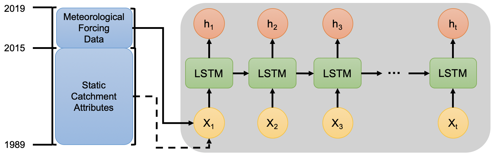
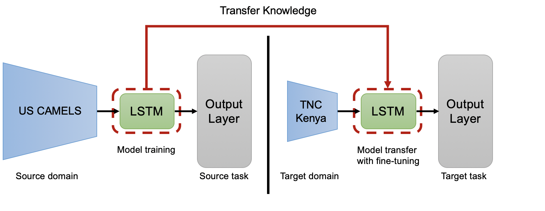
In this paper, we applied Transfer Learning (TL), in which the knowledge manifested in one task is applied (or transferred) to similar objective tasks. Specifically, we trained a Long Short-Term Memory (LSTM) on a source domain, and fine-tuned the resulting model towards a target domain. We refer to the source as the collection of inputs used to train the LSTM model, while the target is the significantly smaller dataset used to fit and evaluate the model’s performance. We employed a transfer learning technique that optimizes the weights during training and fine-tunes the parameters on a selected basin during validation. These parameters were then transferred to a replicated multi-layered LSTM network to generalize the streamflow response over different regions. We trained and optimized our model on our source domain using the US Catchment Attributes and Meteorology for Large-Sample Studies (CAMELS-US) dataset, a benchmark dataset that covers 531 basins across the US region (?; ?). We then performed TL over our target domain to generalize the performance using a dataset we curated with The Nature Conservancy (TNC) which covers the Upper Tana River Basin in Kenya. Previous studies have demonstrated that combining categorical geospatial features (e.g., land cover, climate metrics, soil properties) in addition to corresponding dynamic inputs (precipitation, air temperature) helps improve the performance of streamflow prediction for ML-based hydrological models (?). Influenced by this, the structure of the Kenya dataset generated the same static basin feature as additional input to our LSTM model as illustrated in Figure 1. We validated the utility of this approach by conducting extensive experiments to demonstrate effective predictive skill of a standard LSTM model with transfer learning and static descriptors.
The contributions of this paper are as follows:
-
•
We present a novel dataset of hydrological and categorical catchment attributes collected from the Upper Tana River Basin in Kenya, which follows the same structure as the benchmark CAMELS dataset. We highlight examples of scarcity in the temporal and geospatial data collected.
-
•
We propose a transfer learning approach that optimizes the models performance over the CAMEL-US source domain dataset to address the issues of data sparsity in smaller datasets. We use a fine-tuning method that randomly selects a basin that’s performance score was less than 50% the median distribution. The model’s parameters are then transferred over the TNC dataset to fit and predict the streamflow response.
-
•
We present experimental results that compare models using transfer learning and static descriptors to its counterparts. These extensive experiments show the model’s effective predictive skill of forecasting streamflow response where there lacks sufficient data needed for effective generalization.
-
•
Finally, we discuss further research opportunities to apply machine learning to improve water management and conservation practises.
Related Work
Recent advancements in machine learning has led to widespread interest amongst hydrologists and environmental scientists as a solution to address the challenges that persist with streamflow and run-off forecasting. While previous works have approached performance levels of state-of-the-art physics-based methods (?; ?; ?), the challenge remains whether it can generalize in different domains, and specifically if it can perform in regions with limited training data. Hence, we review the existing literature on transfer learning techniques and its applicability for use cases around hydrology.
Previous works such as (?) categorize the types of transfer learning as inductive, transductive, and unsupervised, which has built foundation for many techniques used in machine learning, more specifically, time-series forecasting (?; ?; ?). For instance, Lin et al. (?) forecasts traffic conditions in poorly monitored urban areas through a transfer learning approach that extracts useful spatio-temporal features from data-rich traffic areas. McCarthy et al. (?) has shown that using a unified vector representation approach between the source and target data to transfer knowledge in heterogeneous feature spaces improves flight delay forecasting. Fawaz et al. (?) uses convolutional neural networks (CNNs) to invoke transfer learning by fine-tuning the weights of a pre-trained CNN model over the UCR time-series benchmark dataset for classification tasks. In cases relevant to hydrology, Kimura et al. (?) implements a feature-representation transfer approach via a CNN from time-series data for predicting floods. The CNN takes advantage of low-level feature extraction to transfer knowledge in a target domain based on a pre-processing conversion mechanism between the spatial imagery and time-dependent data inputs. Gang et al. (?) addresses the data-sparsity issue in small and inconsistent target datasets via transfer learning to improve the performance of flood forecasting in both data-rich and data-sparse urban areas. The success of transfer learning, however, has mainly been applied in computer vision for low to mid-level feature mapping or implementing a freezing mechanism on CNNs to reduce computational overhead. There presents a lack of literature on transfer learning used for LSTM networks and other variations of RNNs. In addition, data sparsity and inconsistency remains a critical issue behind the performance degradation in generalization.
Physics- or empirical-based hydrological models are well established in the literature with research in the space receiving significant impetus with the US Clean Water Act of 1977. In these systems, the hydrological processes of water movement are represented by finite difference equations that are resolved over defined spatial and temporal ranges. Data inputs to resolve streamflow processes include meteorological forcing and a large number of parameters describing the physical characteristics of the catchment (soil moisture content, initial water depth, topography, topology, dimensions of river network, etc.) (?). Popular modelling systems include SWAT (?), MIKE SHE (?), and the VIC framework (?). On the SWAT model alone, there are over 4,500 peer-reviewed journal articles describing its application to different hydrology studies (?).
More recently, extensive research efforts have focused on the potential of deep learning (DL) for hydrology studies (?; ?). In particular, research has focused on the potential of recurrent networks and LSTM to resolve the complex, nonlinear, spatiotemporal relationship between meteorological forcing, soil moisture and streamflow (?). In a provocative recent paper, (?) argued that there is significantly more information in large-scale hydrological data sets than hydrologists have been able to translate into theory or models. This argument for increased scientific insight and performance from machine learning rests on the assumption that large-scale data sets are available globally (over sufficient historical periods) to condition and inform on hydrological response. While significant progress on hydrology dataset curation has been achieved in the US (?; ?), and Europe (?) this is not implemented for many other regions. Inspired by the existing research contributions, we investigate and apply a transfer learning approach to address the issue of data sparsity when forecasting the streamflow response of catchment areas.
Data Collection
The Tana River supplies 95% of Nairobi’s water and half of the country’s energy. The entire Tana River Basin covers and is home to millions of wildlife species as well local communities (?). Since the 1970s, the number of small subsistence farms in the upper basin has skyrocketed (?). The dual effects of climate change and rapid population growth are leading to increased sediment erosion in the Upper Tana River Basin, reducing the capacity of reservoirs, and increasing water treatment costs. Water scarcity is predicted to disproportionately affect communities that have least contributed to climate change, such as the millions of farmers and fishermen who rely on the Tana River and its tributaries for survival and economic prosperity. Taking action now to prevent further damage and help these communities preserve their water resources is critical to ensure the region’s water security for the future. To this end, The Nature Conservancy created a water fund, an organization that brings together public and private stakeholders to address threats to water security at their source through targeted, long-term investments in watershed conservation and management activities (?). In 2015, The Nature Conservancy established the Upper Tana-Nairobi Water Fund as the first of its kind in Africa. The Water Fund aims to improve water quality and quantity for all stakeholders, and is founded on the principle that it is less expensive to prevent water problems at the source than it is to address them further downstream.
The primary focus of the Upper Tana-Nairobi Water Fund (UTNWF) is to improve farming practices in the watershed. Water Fund partners work with almost 50,000 farmers to provide the skills, training and resources they need to conserve water, reduce soil runoff, and improve productivity. Effective management of water conservation activities require quantitative metrics on differences in water availability in different areas of the watershed, subject to different water conservation strategies (and control watersheds with no intervention). Previously, TNC have relied on a combination of SWAT model simulations together with data measurements to inform Water Fund operations (?). However, this comes with the challenges outlined earlier related to computational cost, complexity, and need for high level of user expertise.
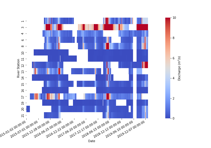
UTNWF collects a relatively rich hydrologic dataset that provides opportunities for DL-based forecasting. Data were collected from February 2015 to January 2020 at 26 stream locations as described in Table 1 in (?). Data on water level and temperature were collected at 30-minute intervals using Onset HOBO water level data logger. HOBO loggers are a robust, widely-used tool to continuously monitor water level and temperature with specified device accuracy of 0.1%. A standard challenge in hydrology is that water level data are easy to measure with low cost equipment while flow or discharge are difficult to measure requiring sophisticated equipment and experienced personnel. On the other hand, water level communicate little meaningful information with streamflow or discharge necessary to quantify water availability and hydrological processes.
Water level data were converted to streamflow using established heuristic relationship between water level and discharge (termed stage–discharge rating curve analysis) (?). This required the collection of streamflow data, development of water level-streamflow rating curve or relationships, and using the generated relationship to convert water level measurements to streamflow. Flow measurements were collected using an Acoustic Doppler Current Profiler (ADCP) instrument. An ADCP is a type of sonar that measures and records water current velocities over a range of depths using the Doppler effect of sound waves scattered back from particles within the water column. Point measurements were collected at multiple locations across the river channel and these used to compute the streamflow discharge at a point in time. Collecting these measurements under multiple streamflow conditions allows one to create the water level discharge relationship. In our case, flow measurements were collected at each station between 50–200 times over the study period. Where sufficient flow data were not available robust streamflow relationships could not be generated. The HOBO water level measurements were converted to streamflow measurements using the above process (19 of the 26 stations had suitable flow measurements) and data were resampled from 30 minute intervals to daily values. Figure 2 presents a heatmap illustrating range of observed values and also highlighting challenges related to data sparsity. For most stations, there are periods when data was not recorded, extending for up to 50% of the time at some stations. While this is a challenge for DL, it also highlights the possibility of using DL models to address data gaps and inform hydrology processes.
Proposed Approach
In this section, we first introduce a standard recurrent neural network, specifically Long Short-Term Memory (LSTM), that uses a loss function commonly used in hydrology. We then describe in detail the method behind our transfer learning approach.
Model Architecture
We propose a multi-layer LSTM network as the base model to perform transfer learning through two separate domains, as shown in Figure 3. We set up our deep learning architecture from the open-source work of (?; ?), where the inputs are dynamic features from water catchment processes such as: min/max air temperature, vapor pressure, and precipitation. The aim of the hydrological LSTM model is to learn the prediction of the continuous streamflow response on a target dataset (Kenya) from the long-term dependent features given the knowledge learned from a large source domain dataset (US CAMELS).
To calculate the model’s performance of streamflow prediction, we present the use of Nash-Sutcliffe efficiency (NSE) (?), which is a statistical estimator that measures the predictive skill of a hydrological model. NSE is defined as:
| (1) |
where is the modeled discharge (streamflow) at time , and is the observed discharge at time . The value of the NSE varies on the interval , where a set of conditions are used as criteria for understanding model performance. denotes equivalent predictive skill of the model to the mean of the time-series (i.e., sum of squared errors). In a perfect model situation, is when the estimation error variance equal to zero. If , the estimation error variance of the model is larger than the variance of observation. Hence, if the observed mean is a better predictor than the model, then the model has little predictive skill.
Similar models such as mean squared error (MSE) are widely adopted for calibration and model evaluation with observed data (?). Unlike MSE, NSE does not overweight catchments with larger streamflow values, which could have influence on the models performance (?) (Figure 2 indicates the large data ranges involved). Hence, this study focuses solely on the performance of the hydrological model through the NSE coefficient.
Transfer Learning Approach
Given a LSTM model that fits over a domain dataset where is the set of inputs and is the set of labels , we define a source source domain dataset to be and a target domain dataset to be . We also define a domain task where we denote the source task domain as and the target task domain as . The objective transfer function learning aims to learn the target conditional probability distribution in with the knowledge gained from both and , where or (?).
The source and target domains share similar feature input space, however labels and are heterogeneous. Hence, the LSTM model cannot be fine-tuned directly on the target domain dataset due to the discrepancy of task objectives. A common technique to transfer knowledge and fine-tune is to split between an LSTM model representation (parametrized by ) and the task-oriented head–which is the topmost layer used for regression–denoted as (parametrized by ). The head of the LSTM model can be replaced with (parametrized to ), where a random initialization is used to fit the distribution of target domain label . We can then perform a standard fine-tuning method over a loss function in Equation 2 for parameter optimization:
| (2) |
Using Equation 1, we apply the replacement and initialization of the LSTM regression layer to refine the NSE loss function as:
| (3) |
The loss function in Equation 3 enables the LSTM model to use its learned weights as a starting point for training as opposed to traditional random initialization methods such as Gaussian distribution. Hence, this yields an opportunity at improving the generalization performance of predicting streamflow response.
| TNC Dataset in Kenya Region | ||||||
| Model | ||||||
| -0.85 | -30.70 | 0.58 | -1259.73 | 2.08 | 2 | |
| -0.93 | -19.70 | 0.62 | -423.45 | 1.29 | 1 | |
| -0.49 | -14.33 | 0.53 | -314.46 | 0.46 | 3 | |
| -0.51 | -17.48 | 0.67 | -577.23 | 1.02 | 3 | |
Experiments
Experimental Setup
Datasets We collected data from two primary sources: (i) US CAMELS and (ii) TNC. The US CAMELS (?) is a large sample benchmark dataset that has covered temporal and geospatial information related hydrology across 531 basins from October 1st, 1980 through September 30th, 2014. All of the LSTM model calibration – which is utilized for transfer learning – was performed from October 1st, 1999 through September 30th, 2008, while the evaluations were performed from October 1st, 1989 through September 30th, 1999. The total time period used for model simulation over the geospatial input data amounts to 10,227 days (28 years).
The Kenya dataset contained hydrological data from 2015-2019, in which 26 river stations were gauged. However, only 12 had sufficient hydrological data (i.e. observations were available of time) to use for this study. We combined with geospatial static catchment attributes to characterise the hydrological profile of the area similar to the US CAMELS data. These categorical static attributes included: catchment area, elevation, and slope, mean precipitation, high and low precipitation frequency and duration, mean evapotranspiration, and aridity (ratio of precipitation and evapotranspiration), and vegetation indices such as leaf area index and NDVI.
Suitably conditioned data were available from 01/09/2015–16/10/2019 which was split into training between period 01/09/2015–22/02/2018 and testing from 22/02/2018–16/10/2019.
The total time period used for this experiment is 1,507 days ( 4 years). In both datasets, we leverage the same subset of geospatial features which include land cover, climate, soils, as well as dynamic meteorological descriptors. The target variable is a continuous value of the daily observed streamflow (or discharge) at each station.
Model Comparison We present the following models used for this experiment:
-
•
Standard LSTM: We employ a standard multi-layered LSTM network based on the existing work on predicting streamflow (?; ?). The output layer uses a regression head to simulate the discharge over unseen data.
-
•
LSTM with static catchment attributes(SCA) (): We incorporate static basin descriptors related to land cover, soil, climate, vegetation, and topography that has shown to augment ability for the LSTM to generalize (?).
-
•
LSTM with transfer learning (): We present the existing transfer learning solution using an LSTM over the US CAMELS dataset. The weights are transferred to generalize over the Kenya dataset.
-
•
LSTM with TL + SCA (): We combine the ability of additional catchment attributes to augment the model performance along with our proposed transfer learning approach.
Hyperparameters and Evaluation Metrics The hyperparameters of the baseline models were employed uniformly. The LSTM network structure consisted of 128 hidden units and 1 output regression layer used for forecasting daily streamflow over 30 epochs. We initialize the learning rate to 0.001 during the first epoch and adjust to 0.0005 over the remaining epochs. To penalize inconsistent predictions, we implement an ADAM optimizer as our regularization term.
Our primary evaluation metric for this study is the Nash-Sutcliffe model Efficiency estimation (NSE) (?), which estimation of predicting discharge compared to similar metrics such as MSE and RMSE. We leveraged six statistical metrics from our generated NSE values to calculate the performance of the propose models which include: median (), mean (), maximum (), min (), standard deviation (), and number of basins where the NSE value is greater than 0 ().
Comparing Proposed Methods
We evaluated the performance of each proposed model over the TNC Kenya dataset and compared their results based on our aforementioned metrics. From Table 1, the displayed the best overall performance, notably achieving a higher and score. The optimized weights served as a better starting point for the target LSTM model than random initialization. Augmenting the standard LSTM model with static catchment attributes (i.e., , ) showed a lack of improvement in performance relative to their counterparts. While some modest improvement of mean NSE and standard deviation were reported by addition of SCA to baseline LSTM, this did not translate to the model with transfer learning. This likely results from the different scale of geospatial datasets used in the CAMELS and Kenya dataset which may require some statistical conditioning to resolve more closely. As an example climate indicators for Kenya were extracted from the ECMWF ERA5 global reanalysis product at horizontal resolution of while the US CAMELS dataset used the US National N15 Daymet dataset at resolution of . The difference in the standard deviation (Std) between the standard LSTM model and (2.08 vs. 0.46) was largely due to the lack of temporal streamflow observations that cause large gaps during model training and validation. Employing transfer learning from a model train on a significantly richer source domain enables the model to reduce deviation for producing more effective results on unseen streamflow.
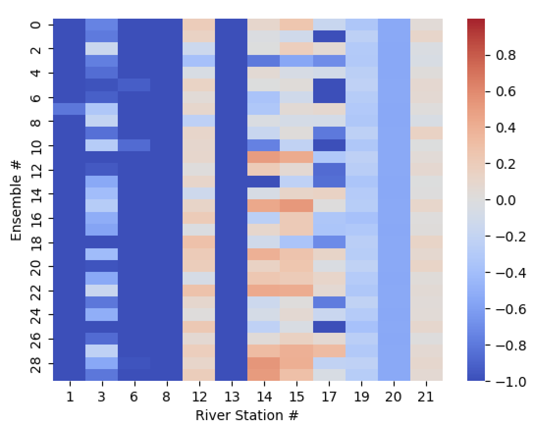
Figure 4 reports the performance of 30 model instances trained with random initialization. It indicates that 4 of the 12 stations reported while 3 reported and further 3 had values . While these values return moderate predictive skill, they present a promising demonstration of the potential of transfer learning to address the combined challenge of data sparsity, data uncertainty, and complex physical and empirical relationships.
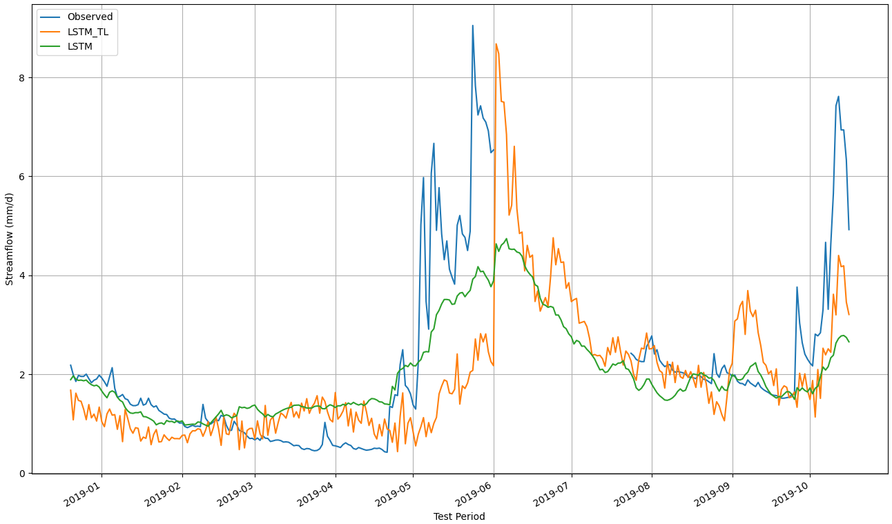
In Figure 5, we compare the performance of the proposed transfer learning model () with a baseline model to predict the streamflow response at a given station. Herein, demonstrates the ability of the transfer learning model to address the limitations of data collection in areas where geospatial information is sparse and inconsistent. Compared to the standard LSTM model, () provides a more realistic prediction over the TNC Kenya dataset by leveraging the learned weights from a data-rich source domain dataset (US CAMELS). Thus, the simulated streamflow from the () model can be of more effective use in informing stakeholders in developing areas (e.g., farmers, Kenyan water funds) about the water availability within the Kenyan region for better water resource management.
Discussion
While employing transfer learning has many implications of success, as demonstrated by the improved performance of the standard LSTM model, there still presents many concerns regarding its applicability for time series tasks. Successful transfer learning theories and application has largely been applied to computer vision tasks (?; ?). Transfer learning has also seen success in multi-lingual machine translation as it has the ability to create word representation (embeddings) (?; ?). However, this success has not been extended to time-series related tasks due to the lack of existing literature in both theory and application. Time-series models may be elusive, as it is harder to find a useful hierarchy or a set of intermediate representations that could generalize to different domains. In addition, negative transfer learning is a common challenge as it can negatively affect performance when performing knowledge transferring from a source to a target domain (?).
Furthermore, the initiatives to improve hydrological modeling have equally, if not more so, relied on sufficient data collection processes as it does on the model’s underlying algorithm. The sparsity and inconsistency of the Upper Tana dataset caused performance issues related to the predictive streamflow skill. This can be due to the lack of equipment used to track meteorological data such as precipitation and air temperature in developing countries. The US and many areas across Europe, on the other hand, have had the means of curating large-sample datasets through the accessible resources of weather tracking at their disposal. The insufficient data of tracking meteorological information in countries from Africa presents an issue of informing stakeholders (e.g., farmers, water funds) about the water quality and availability for proper water resource management. Programs such as The trans-African hydro-meteorological observatory (TAHMO) (?) which aims for continuous monitoring of precipitation data across Sub-Saharan Africa are key initiatives to allow for more effective, applied DL to hydrology. In addition, the resolution provided by different geoscientific monitoring and modelling tools such as NASA and European Centre for Medium Weather Forecasting (ECMWF) at continental and global scales could be reconciled towards higher resolution in places such as Kenya (to provide resolution comparable to that currently provided for US and Europe by the respective organisations). Approaches for statistical downscaling of these global datasets (e.g. (?)) could improve the performance of transfer learning across different geographies.
Conclusion
The science of hydrology has largely derived from using known physical and empirical relationships – guided by user expertise and intuition – to resolve complex rainfall – discharge relationships. Huge potential exists to use deep learning to augment these inference and intuition from large hydrological datasets. A fundamental challenge currently is data sparsity.
In this paper, we address the limitations of streamflow predictions in data sparse regions using transfer learning. We first address the underlying problem by collecting, pre-processing, and curating a dataset, (TNC Kenya), similar to that of US CAMELS, which has the same dynamic meteorological input features and the same set of static features describing each catchment area. Our approach attempts to generalize a model in small target domain datasets given knowledge learned from a significantly larger source domain dataset by knowledge transfer. We employ a multi-layer LSTM model to forecast streamflow response using the dynamic meteorological inputs as well as static catchment descriptors. We experimented with the predictive skill of forecasting streamflow under four conditions concerning transfer learning, static catchment attributes, both, or neither. Our results demonstrate the improved performance and potential of transfer learning to give insights on streamflow prediction in areas where data is sparse due to the lack of temporal and geospatial resources. Our future work aims to look at other drivers of predictive streamflow forecasting using spatial-temporal methods such as graph neural networks and convolutional neural networks.
References
- [Addor et al. 2017] Addor, N.; Newman, A. J.; Mizukami, N.; and Clark, M. P. 2017. The camels data set: catchment attributes and meteorology for large-sample studies. Hydrology and Earth System Sciences 21(10):5293–5313.
- [Aji et al. 2020] Aji, A. F.; Bogoychev, N.; Heafield, K.; and Sennrich, R. 2020. In neural machine translation, what does transfer learning transfer? In Proceedings of the 58th Annual Meeting of the Association for Computational Linguistics, 7701–7710.
- [Akoko et al. 2021] Akoko, G.; Le, T. H.; Gomi, T.; and Kato, T. 2021. A review of swat model application in africa. Water 13(9):1313.
- [Arnold et al. 2012] Arnold, J. G.; Moriasi, D. N.; Gassman, P. W.; Abbaspour, K. C.; White, M. J.; Srinivasan, R.; Santhi, C.; Harmel, R.; Van Griensven, A.; Van Liew, M. W.; et al. 2012. Swat: Model use, calibration, and validation. Transactions of the ASABE 55(4):1491–1508.
- [Baker and Miller 2013] Baker, T. J., and Miller, S. N. 2013. Using the soil and water assessment tool (swat) to assess land use impact on water resources in an east african watershed. Journal of hydrology 486:100–111.
- [Boretti and Rosa 2019] Boretti, A., and Rosa, L. 2019. Reassessing the projections of the world water development report. NPJ Clean Water 2(1):1–6.
- [Devia, Ganasri, and Dwarakish 2015] Devia, G. K.; Ganasri, B. P.; and Dwarakish, G. S. 2015. A review on hydrological models. Aquatic procedia 4:1001–1007.
- [Fawaz et al. 2018] Fawaz, H. I.; Forestier, G.; Weber, J.; Idoumghar, L.; and Muller, P.-A. 2018. Transfer learning for time series classification. In 2018 IEEE international conference on big data (Big Data), 1367–1376. IEEE.
- [Gang et al. 2021] Gang, Z.; Bo, P.; Zongxue, X.; Lizhuang, C.; Jingjing, W.; Depeng, Z.; and Dingzhi, P. 2021. Improving urban flood susceptibility mapping using transfer learning. Journal of Hydrology 126777.
- [Gao et al. 2010] Gao, H.; Tang, Q.; Shi, X.; Zhu, C.; Bohn, T.; Su, F.; Pan, M.; Sheffield, J.; Lettenmaier, D.; and Wood, E. 2010. Water budget record from variable infiltration capacity (vic) model. In Algorithm Theoretical Basis Document for Terrestrial Water Cycle Data Records.
- [Gassman et al. 2007] Gassman, P. W.; Reyes, M. R.; Green, C. H.; and Arnold, J. G. 2007. The soil and water assessment tool: historical development, applications, and future research directions. Transactions of the ASABE 50(4):1211–1250.
- [Graham and Butts 2005] Graham, D. N., and Butts, M. B. 2005. Flexible, integrated watershed modelling with mike she. Watershed models 849336090:245–272.
- [Gupta et al. 2009] Gupta, H. V.; Kling, H.; Yilmaz, K. K.; and Martinez, G. F. 2009. Decomposition of the mean squared error and nse performance criteria: Implications for improving hydrological modelling. Journal of hydrology 377(1-2):80–91.
- [Howard and Ruder 2018] Howard, J., and Ruder, S. 2018. Universal language model fine-tuning for text classification. In Proceedings of the 56th Annual Meeting of the Association for Computational Linguistics (Volume 1: Long Papers), 328–339.
- [Hsu, Gupta, and Sorooshian 1995] Hsu, K.-l.; Gupta, H. V.; and Sorooshian, S. 1995. Artificial neural network modeling of the rainfall-runoff process. Water resources research 31(10):2517–2530.
- [Hunink et al. 2011] Hunink, J.; Immerzeel, W.; Droogers, P.; Kauffman, J.; and van Lynden, G. 2011. Impacts of land management options in the upper tana, kenya, using the soil and water assessment tool—swat. Green Water Credits Report 10.
- [Jacobs et al. 2007] Jacobs, J.; Angerer, J.; Vitale, J.; Srinivasan, R.; and Kaitho, R. 2007. Mitigating economic damage in kenya’s upper tana river basin: An application of arc-view swat. Journal of Spatial Hydrology 7(1).
- [Jakob Themeßl, Gobiet, and Leuprecht 2011] Jakob Themeßl, M.; Gobiet, A.; and Leuprecht, A. 2011. Empirical-statistical downscaling and error correction of daily precipitation from regional climate models. International Journal of Climatology 31(10):1530–1544.
- [Kimura et al. 2020] Kimura, N.; Yoshinaga, I.; Sekijima, K.; Azechi, I.; and Baba, D. 2020. Convolutional neural network coupled with a transfer-learning approach for time-series flood predictions. Water 12(1):96.
- [Klingler, Schulz, and Herrnegger 2021] Klingler, C.; Schulz, K.; and Herrnegger, M. 2021. Lamah— large-sample data for hydrology and environmental sciences for central europe. Earth System Science Data Discussions 1–46.
- [Kratzert et al. 2019a] Kratzert, F.; Herrnegger, M.; Klotz, D.; Hochreiter, S.; and Klambauer, G. 2019a. Neuralhydrology–interpreting lstms in hydrology. In Explainable AI: Interpreting, explaining and visualizing deep learning. Springer. 347–362.
- [Kratzert et al. 2019b] Kratzert, F.; Klotz, D.; Herrnegger, M.; Sampson, A. K.; Hochreiter, S.; and Nearing, G. S. 2019b. Toward improved predictions in ungauged basins: Exploiting the power of machine learning. Water Resources Research 55(12):11344–11354.
- [Kratzert et al. 2019c] Kratzert, F.; Klotz, D.; Shalev, G.; Klambauer, G.; Hochreiter, S.; and Nearing, G. 2019c. Towards learning universal, regional, and local hydrological behaviors via machine learning applied to large-sample datasets. Hydrology and Earth System Sciences 23(12):5089–5110.
- [Leisher et al. 2018] Leisher, C.; Makau, J.; Kihara, F.; Kariuki, A.; Sowles, J.; Courtemanch, D.; Njugi, G.; and Apse, C. 2018. Upper Tana-Nairobi Water Fund Monitoring and Evaluation Plan. Technical report, The Nature Conservancy, Kenya.
- [Lin et al. 2018] Lin, B. Y.; Xu, F. F.; Liao, E. Q.; and Zhu, K. Q. 2018. Transfer learning for traffic speed prediction: A preliminary study. In Workshops at the Thirty-Second AAAI Conference on Artificial Intelligence.
- [Long et al. 2017] Long, M.; Zhu, H.; Wang, J.; and Jordan, M. I. 2017. Deep transfer learning with joint adaptation networks. In International conference on machine learning, 2208–2217. PMLR.
- [McCarthy, Karzand, and Lecue 2019] McCarthy, N.; Karzand, M.; and Lecue, F. 2019. Amsterdam to dublin eventually delayed? lstm and transfer learning for predicting delays of low cost airlines. In Proceedings of the AAAI Conference on Artificial Intelligence, volume 33, 9541–9546.
- [Nash and Sutcliffe 1970] Nash, J. E., and Sutcliffe, J. V. 1970. River flow forecasting through conceptual models part i—a discussion of principles. Journal of hydrology 10(3):282–290.
- [Nearing et al. 2020] Nearing, G.; Kratzert, F.; Klotz, D.; Hoedt, P.-J.; Klambauer, G.; Hochreiter, S.; Gupta, H.; Nevo, S.; and Matias, Y. 2020. A deep learning architecture for conservative dynamical systems: Application to rainfall-runoff modeling. AI for Earth Sciences Workshop at NeurIPS.
- [Nearing et al. 2021] Nearing, G. S.; Kratzert, F.; Sampson, A. K.; Pelissier, C. S.; Klotz, D.; Frame, J. M.; Prieto, C.; and Gupta, H. V. 2021. What role does hydrological science play in the age of machine learning? Water Resources Research 57(3):e2020WR028091.
- [Newman et al. 2014] Newman, A.; Clark, M.; Sampson, K.; Wood, A.; Hay, L.; Bock, A.; Viger, R.; Blodgett, D.; Brekke, L.; Arnold, J.; et al. 2014. Development of a large-sample watershed-scale hydrometeorological dataset for the contiguous usa: dataset characteristics and assessment of regional variability in hydrologic model performance. Hydrology and Earth System Sciences Discussions 11(5):5599–5631.
- [Newman et al. 2015] Newman, A.; Clark, M.; Sampson, K.; Wood, A.; Hay, L.; Bock, A.; Viger, R.; Blodgett, D.; Brekke, L.; Arnold, J.; et al. 2015. Development of a large-sample watershed-scale hydrometeorological data set for the contiguous usa: data set characteristics and assessment of regional variability in hydrologic model performance. Hydrology and Earth System Sciences 19(1):209–223.
- [Njogu and Kitheka 2017] Njogu, I. N., and Kitheka, J. U. 2017. Assessment of the influence of rainfall and river discharge on sediment yield in the upper tana catchment in kenya. Technical report, OMICS International.
- [Pan and Yang 2009] Pan, S. J., and Yang, Q. 2009. A survey on transfer learning. IEEE Transactions on knowledge and data engineering 22(10):1345–1359.
- [Shamshirband et al. 2020] Shamshirband, S.; Hashemi, S.; Salimi, H.; Samadianfard, S.; Asadi, E.; Shadkani, S.; Kargar, K.; Mosavi, A.; Nabipour, N.; and Chau, K.-W. 2020. Predicting standardized streamflow index for hydrological drought using machine learning models. Engineering Applications of Computational Fluid Mechanics 14(1):339–350.
- [Shen 2018] Shen, C. 2018. A transdisciplinary review of deep learning research and its relevance for water resources scientists. Water Resources Research 54(11):8558–8593.
- [Srinivasan and Balmer 2021] Srinivasan, R., and Balmer, C. 2021. SWAT Literature Database for Peer-Reviewed Journal Articles.
- [TNC 2015] TNC. 2015. Upper Tana-Nairobi Water Fund A Business Case. Version 2. Technical report, The Nature Conservancy, Nairobi, Kenya.
- [TNC 2020] TNC. 2020. Investing in Nature to Improve Water Security (Water Funds). Technical report, The Nature Conservancy, Nairobi, Kenya.
- [Torrey and Shavlik 2010] Torrey, L., and Shavlik, J. 2010. Transfer learning. In Handbook of research on machine learning applications and trends: algorithms, methods, and techniques. IGI global. 242–264.
- [Turnipseed and Sauer 2010] Turnipseed, D. P., and Sauer, V. B. 2010. Discharge measurements at gaging stations. Technical report, US Geological Survey.
- [van de Giesen, Hut, and Selker 2014] van de Giesen, N.; Hut, R.; and Selker, J. 2014. The trans-african hydro-meteorological observatory (tahmo). Wiley Interdisciplinary Reviews: Water 1(4):341–348.
- [Vogl et al. 2017] Vogl, A. L.; Bryant, B. P.; Hunink, J. E.; Wolny, S.; Apse, C.; and Droogers, P. 2017. Valuing investments in sustainable land management in the upper tana river basin, kenya. Journal of Environmental Management 195:78–91.
- [Ye and Dai 2018] Ye, R., and Dai, Q. 2018. A novel transfer learning framework for time series forecasting. Knowledge-Based Systems 156:74–99.
- [Young, Liu, and Wu 2017] Young, C.-C.; Liu, W.-C.; and Wu, M.-C. 2017. A physically based and machine learning hybrid approach for accurate rainfall-runoff modeling during extreme typhoon events. Applied Soft Computing 53:205–216.
- [Zamir et al. 2018] Zamir, A. R.; Sax, A.; Shen, W.; Guibas, L. J.; Malik, J.; and Savarese, S. 2018. Taskonomy: Disentangling task transfer learning. In Proceedings of the IEEE conference on computer vision and pattern recognition, 3712–3722.
- [Zoph et al. 2016] Zoph, B.; Yuret, D.; May, J.; and Knight, K. 2016. Transfer learning for low-resource neural machine translation. In Proceedings of the 2016 Conference on Empirical Methods in Natural Language Processing, 1568–1575.