TorchGeo: Deep Learning With Geospatial Data
Abstract.
Remotely sensed geospatial data are critical for applications including precision agriculture, urban planning, disaster monitoring and response, and climate change research, among others. Deep learning methods are particularly promising for modeling many remote sensing tasks given the success of deep neural networks in similar computer vision tasks and the sheer volume of remotely sensed imagery available. However, the variance in data collection methods and handling of geospatial metadata make the application of deep learning methodology to remotely sensed data nontrivial. For example, satellite imagery often includes additional spectral bands beyond red, green, and blue and must be joined to other geospatial data sources that can have differing coordinate systems, bounds, and resolutions. To help realize the potential of deep learning for remote sensing applications, we introduce TorchGeo, a Python library for integrating geospatial data into the PyTorch deep learning ecosystem. TorchGeo provides data loaders for a variety of benchmark datasets, composable datasets for generic geospatial data sources, samplers for geospatial data, and transforms that work with multispectral imagery. TorchGeo is also the first library to provide pre-trained models for multispectral satellite imagery (e.g., models that use all bands from the Sentinel-2 satellites), allowing for advances in transfer learning on downstream remote sensing tasks with limited labeled data. We use TorchGeo to create reproducible benchmark results on existing datasets and benchmark our proposed method for preprocessing geospatial imagery on the fly. TorchGeo is open source and available on GitHub: https://github.com/microsoft/torchgeo.
1. Introduction
With the explosion in availability of satellite and aerial imagery over the past decades, there has been increasing interest in the use of imagery in remote sensing (RS) applications. These applications range from precision agriculture (Mulla, 2013) and forestry (Lu et al., 2016), to natural and man-made disaster monitoring (Van Westen, 2013), to weather and climate change (Rolnick et al., 2019). At the same time, advancements in machine learning (ML), larger curated benchmark datasets, and increased compute power, have led to great successes in domains like computer vision, natural language processing, and audio processing. However, the wide-spread success and popularity of machine learning—particularly of deep learning methods—in these domains has not fully transferred to the RS domain, despite the existence of petabytes of freely available satellite imagery and a variety of benchmark datasets for different RS tasks. This is not to say that there are not successful applications of ML in RS, but that the full potential of the intersection of these fields has not been reached. Indeed, a recent book by Camps-Valls et al. (2021) thoroughly details work at the intersection of deep learning, geospatial data, and the Earth sciences. Increasing amounts of research on self-supervised and unsupervised learning methods specific to remotely sensed geospatial imagery (Mañas et al., 2021; Ayush et al., 2021; Jean et al., 2019) bring the promise of developing generic models that can be tuned to various downstream RS tasks. Recent large-scale efforts, such as the creation of a global 10 m resolution land cover map (Karra et al., 2021b) or the creation of global 30 m forest maps (Rogan et al., 2008), pair the huge amount of available remotely sensed imagery with modern GPU accelerated models. To reach the full joint potential of these fields, we believe that we need tools for facilitating research and managing the complexities of both geospatial data and modern machine learning pipelines. We describe the challenges of this below, and detail our proposed solution, TorchGeo.
One major challenge in many RS tasks is the large amount of diversity in content of geospatial imagery datasets compared to datasets collected for traditional vision applications. For example, most conventional cameras capture 3-channel RGB imagery, however most satellite sensors capture different sets of spectral bands. The Landsat 8 satellite (Roy et al., 2014) collects 11 bands, the Sentinel-2 satellites (Drusch et al., 2012) collect 12 bands, and the Hyperion satellite (Pearlman et al., 2003) collects 242 (hyperspectral) bands, each measuring different regions of the electromagnetic spectrum. The exact wavelengths of the electromagnetic spectrum captured by each band can range from 400 nm to 15 m. In addition, different sensors capture imagery at different spatial resolutions: satellite imagery resolution can range from 4 km/px (GOES (of Satellite and Operations, 1994)) to 30 cm/px (Maxar WorldView satellites (Technologies, 2021)), while imagery captured from drones can have a resolution as high as 7 mm/px (AG, 2021). Depending on the type of orbit a satellite is in, imagery can be continuous (for geostationary orbits) or daily to biweekly (for polar, sun-synchronous orbits). Machine learning models or algorithms developed for one of these platforms will not generalize across inputs collected by the others, and, as a consequence of this, it is not possible to publish a single set of pre-trained model weights that span imaging platforms. In contrast, ImageNet (Deng et al., 2009) pretrained models have been proven to be useful in a large number of transfer learning tasks (Yosinski et al., 2014). Researchers and practitioners can often start with ImageNet pre-trained models in a transfer learning setup when presented with vision problems to reduce the overall amount of training needed to solve the problem. Further, it is not clear whether the inductive biases built into common modeling approaches for vision problems are immediately applicable to remotely sensed imagery. Large neural architecture search efforts (Liu et al., 2018) produce models that are optimized for and outperform hand-designed architectures on vision tasks, but it is an open question whether these transfer to remotely sensed imagery.
Most machine learning libraries have not been designed to work with geospatial data. For example, the Python Imaging Library (PIL) (Clark et al., 2010), used by many libraries to load images and perform data augmentation, does not support multispectral imagery. Similarly, deep learning models implemented by the torchvision library only support 3 channel (RGB) inputs, and must be adapted or re-implemented to support multispectral data. Datasets of geospatial data can be made up of a heterogenous mix of files with differing file formats, spatial resolutions, projections, and coordinate reference systems (CRS). Libraries such as GDAL (GDAL/OGR contributors, 2022) can interface with most types of geospatial data, however further abstractions for using such data in arbitrary deep learning pipelines are limited. Indeed, the gap between loading geospatial data from disk, and using it in a modeling pipeline, is large for all of the reasons mentioned above. As illustrated in Figure 1, users will often need pixel-aligned crops from multiple layers of data: imagery from different points in time over the same space, imagery and corresponding label masks, high-resolution and low resolution imagery from the same space, etc. In contrast, there are a wide variety of software libraries at the intersection of machine learning and other domains. In the PyTorch ecosystem, torchvision (Massa et al., 2016), torchtext (Zhang et al., 2016), and torchaudio (Yang et al., 2021) provide the tools necessary for abstracting the peculiarities of domain-specific data away from the details of deep learning training pipelines.
To address these challenges, we propose TorchGeo, a Python package that allows users to transparently use heterogenous geospatial data in PyTorch-based deep learning pipelines. Specifically, TorchGeo provides:
-
(1)
data loaders for geospatial datasets common in the literature,
-
(2)
data loaders for combining uncurated geospatial raster and vector data layers with the ability to sample pixel-aligned patches on the fly,
-
(3)
augmentations appropriate for multispectral imagery,
-
(4)
data samplers appropriate for geospatial data, and
-
(5)
pre-trained models for many common remotely sensed imagery sources.
In this paper, we formally describe TorchGeo, propose and test methods for sampling from large geospatial datasets, and test the effect of ImageNet pretraining versus random weight initialization on several benchmark datasets. We achieve close to state-of-the-art results on all experimental datasets, despite focusing only on creating simple and reproducible results to serve as baselines for future work to build on. We further find that ImageNet pre-training significantly improves spatial generalization performance in a land cover mapping task. We believe that these results are interesting in their own right, and that they highlight the importance of TorchGeo to the larger machine learning community. TorchGeo is open source and available on GitHub: https://github.com/microsoft/torchgeo.
2. Design
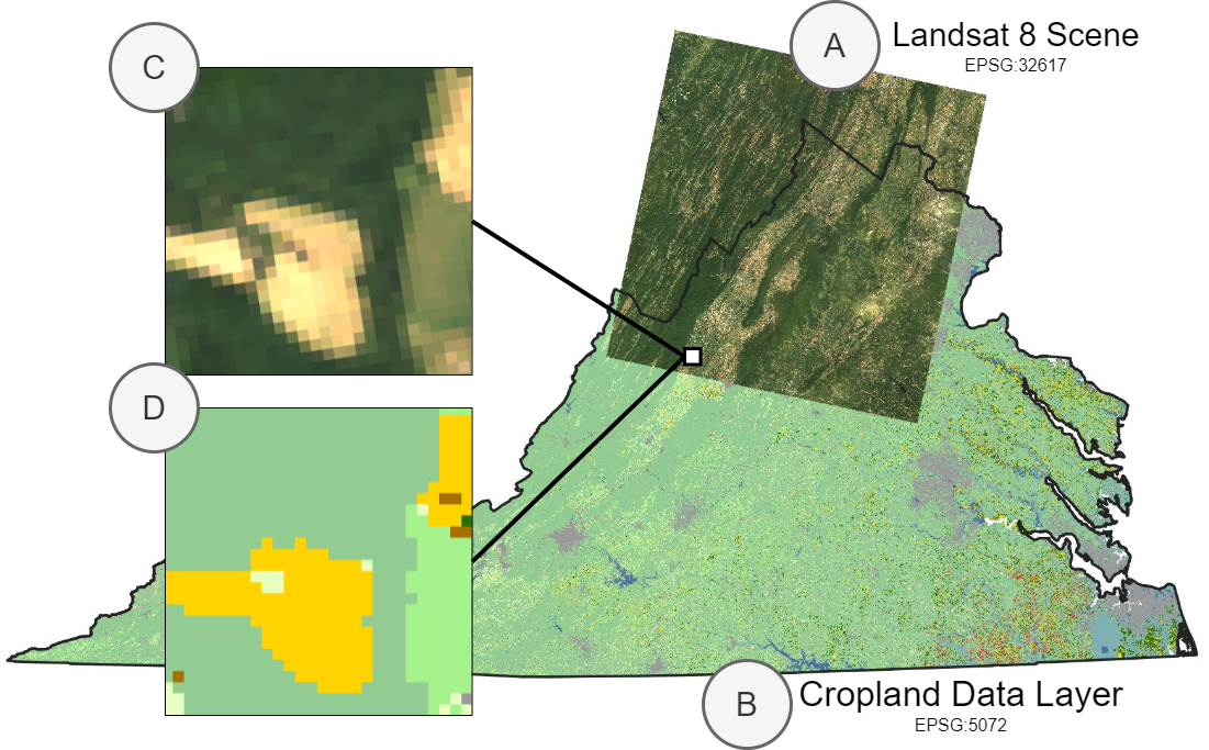
Remotely sensed imagery datasets are usually formatted as scenes, i.e., tensors , where is height, is width, and is the number of spectral channels, with corresponding spatial and temporal metadata. This metadata includes a coordinate reference system (CRS) that maps pixel coordinates to the surface of the Earth, a spatial resolution (the size of each pixel when mapped onto the surface of the Earth), spatial bounds (a bounding box representing the area on Earth that the data covers), and a timestamp or time range to indicate when the data was collected. We say that two datasets, and , are pixel-aligned if and represent data from the same positions on Earth for all . Most pairs of datasets are not aligned by default. For example, and can be captured by two satellites in different orbits and will only have partially overlapping spatial bounds, or will be satellite imagery while will be from a dataset of labels with a different CRS (see Figure 2). However, deep learning model training requires pixel-aligned patches of imagery—i.e., smaller crops from large scenes. Most models are trained with mini-batch gradient descent and require input tensors in the format where is the number of samples in a mini-batch and and are constant over all samples in the batch. At a higher level, training semantic segmentation models requires pairs of pixel-aligned imagery and masks.
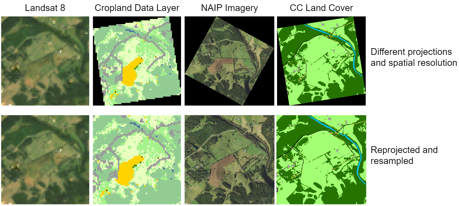
Aligning two datasets requires reprojecting the data from one file in order to match the CRS of the other file, cropping the data to the same spatial bounds, and resampling the data to correct for differences in resolution or to establish the same underlying pixel grid. Typically, these are performed as pre-processing steps using GIS software such as QGIS, ArcGIS, or tools provided by GDAL—see Listing 1 for an example of a GDAL command to align two data layers. This requires some level of domain knowledge to perform correctly and does not scale to large datasets as it requires creating duplicates of the layer to be aligned. Further, this approach still requires an implementation of a dataset or data loader that can sample patches from the pre-processed imagery.
In TorchGeo, we facilitate this process by performing the alignment logic on the fly to create pixel-aligned patches of data sampled from larger scenes. Specifically, we implement the alignment logic in custom PyTorch Dataset classes that are indexed in terms of spatiotemporal coordinates. Given a query in spatiotemporal coordinates, a desired destination CRS, and a desired spatial resolution, the custom dataset is responsible for returning the corresponding reprojected and resampled data for the query. We further implement geospatial data samplers that generate queries according to different criteria (e.g., randomly or in a regular grid pattern). See Section 3 for a discussion on the implementation of these.
As our datasets are indexed by spatiotemporal coordinates, we can easily compose datasets that represent different data layers by specifying a valid area to sample from. For example, if we have two datasets, and , we may want to sample data from the union of the layers, , if both layers cover disparate geospatial locations, or from the intersection of the layers, , if one layer is imagery and the other layer is labels. The latter is particularly powerful for use in applications like multimodal learning (Baltrušaitis et al., 2019) and data fusion (Zhang, 2010). As we describe in the following section, we implement generic dataset classes for a variety of common remotely-sensed datasets (e.g., Landsat imagery) that can be composed in this way. This allows users of the library to create their own multimodal datasets without having to write custom code.
Most importantly, these abstractions that TorchGeo creates—geospatial datasets and samplers—can be combined with a standard PyTorch data loader class to produce fixed size batches of data to be transferred to the GPU and used in training or inference. See Listing 2 for a working example of TorchGeo code for setting up a functional data loader that uses Landsat and Cropland Data Layer (CDL) dataset implementations. Our approach trades off required storage space for data loading time compared to pre-processing all data layers, but, crucially, does not require knowledge of GIS tooling. We benchmark our implementations in Section 4.3.
3. Implementation
The implementation of TorchGeo follows the design of other PyTorch domain libraries to reduce the amount of new concepts that a user must learn to integrate it with their existing workflow. We split TorchGeo up into the following submodules:
- Datasets:
-
Our dataset implementations consist of both benchmark datasets that allow users to interface with common datasets used in RS literature and generic datasets that allow users to interface with common geospatial data layers such as Landsat or Sentinel-2 imagery. Either of these types of datasets can also be geospatial datasets, i.e., datasets that contain geospatial metadata and can be sampled as such. These are part of the core contribution of TorchGeo and we describe them further in the following section.
- Samplers:
-
We implement samplers for indexing into any of our geospatial datasets. Our geospatial datasets are indexed by bounding boxes in spatiotemporal coordinates (as opposed to standard fixed-length datasets of images which are usually indexed by an integer). The samplers generate bounding boxes according to specific patterns: randomly across all scenes in a dataset, random batches from single scenes at a time, or in grid patterns over scenes. Different sampling patterns can be useful for different model training strategies, or for running model inference over datasets.
- Models:
-
Most existing model implementations (e.g., in torchvision) are fixed to accept 3 channel inputs which are not compatible with multispectral imagery. We provide implementations (or wrappers around well-established implementations) of common deep learning model architectures with variable-sized inputs and pre-trained weights, e.g., models that use all of the Sentinel-2 multispectral bands as inputs. We also implement architectures from recent geospatial ML work such as the Fully Convolutional Siamese Network (Daudt et al., 2018a).
- Transforms:
-
Similar to existing model implementations, some existing deep learning packages do not support data augmentation methods for multi-spectral imagery. We provide wrappers for augmentations in the Kornia (Riba et al., 2020) library (which does support augmentations over arbitrary channels) and implement transforms specific to geospatial data.
- Trainers:
3.1. Datasets
| Dataset | Task | Source | # Samples | # Categories | Size (px) | Resolution (m) | Bands |
| ADVANCE (Hu et al., 2020) | C | Google Earth, Freesound | 5,075 | 13 | 0.5 | RGB | |
| BigEarthNet (Sumbul et al., 2019) | C | Sentinel-1/2 | 590,326 | 19–43 | 10 | SAR, MSI | |
| EuroSAT (Helber et al., 2019) | C | Sentinel-2 | 27,000 | 10 | 10 | MSI | |
| PatternNet (Zhou et al., 2018) | C | Google Earth | 30,400 | 38 | 0.06–5 | RGB | |
| RESISC45 (Cheng et al., 2017) | C | Google Earth | 31,500 | 45 | 0.2–30 | RGB | |
| So2Sat (Zhu et al., 2019) | C | Sentinel-1/2 | 400,673 | 17 | 10 | SAR, MSI | |
| UC Merced (Yang and Newsam, 2010) | C | USGS National Map | 21,000 | 21 | 0.3 | RGB | |
| COWC (Mundhenk et al., 2016) | C, R | UAV | 388,435 | 2 | 0.15 | RGB | |
| Tropical Cyclone (Maskey et al., 2020) | R | GOES 8–16 | 108,110 | - | 4K–8K | MSI | |
| USAVars (Rolf et al., 2021b) | R | NAIP | 100K | - | - | 4 | MSI |
| Benin Cashews (Jin et al., 2021) | S | Airbus Pléiades | 70 | 6 | 1,,122 | 0.5 | MSI |
| ETCI 2021 Floods (NASA-IMPACT, 2021) | S | Sentinel-1 | 66,810 | 2 | 5–20 | SAR | |
| GID-15 (Tong et al., 2020) | S | Gaofen-2 | 150 | 15 | 6,,200 | 3 | RGB |
| Kenya Crop Type (Foundation, 2020) | S | Sentinel-2 | 4,688 | 7 | 3,,016 | 10 | MSI |
| LandCover.ai (Boguszewski et al., 2021) | S | Aerial | 10,674 | 5 | 0.25–0.5 | RGB | |
| Potsdam (Rottensteiner et al., 2012) | S | Aerial | 38 | 6 | 6,,000 | 0.05 | MSI |
| SEN12MS (Schmitt et al., 2019) | S | Sentinel-1/2, MODIS | 180,662 | 33 | 10 | SAR, MSI | |
| Vaihingen (Rottensteiner et al., 2012) | S | Aerial | 33 | 6 | 1,281–3,816 | 0.09 | RGB |
| FAIR1M (Sun et al., 2021) | O | Gaofen, Google Earth | 15K | 37 | 1,,024 | 0.3–0.8 | RGB |
| IDTReeS (Graves et al., 2021) | O, C | Aerial | 591 | 33 | 0.1–1 | RGB | |
| NWPU VHR-10 (Cheng et al., 2014) | O, I | Google Earth, Vaihingen | 800 | 10 | 358–1,728 | 0.08–2 | RGB |
| SpaceNet (Van Etten et al., 2018) | I | WorldView, Planet Dove | 1,889–28,728 | 2 | 102–900 | 0.5–4 | MSI |
| ZueriCrop (Turkoglu et al., 2021) | I, T | Sentinel-2 | 116K | 48 | 10 | MSI | |
| Seasonal Contrast (Mañas et al., 2021) | T | Sentinel-2 | 100K–1M | - | 10 | MSI | |
| LEVIR-CD+ (Shen et al., 2021) | D | Google Earth | 985 | 2 | 1,,024 | 0.5 | RGB |
| OSCD (Daudt et al., 2018b) | D | Sentinel-2 | 24 | 2 | 40–1,180 | 60 | MSI |
| xView2 (Gupta et al., 2019) | D | Maxar | 3,732 | 4 | 1,,024 | 0.8 | RGB |
| C = classification, R = regression, S = semantic segmentation, O = object detection, I = instance segmentation, T = time series, D = change detection | |||||||
We organize datasets based on whether they are generic datasets or benchmark datasets and based on whether or not they contain geospatial metadata—i.e., are a geospatial dataset.
Benchmark datasets are datasets released by the community that consist of both inputs and target labels for a specific type of task (scene classification, semantic segmentation, instance segmentation, etc.). These may or may not also contain geospatial metadata that allows them to be joined with other sources of data. In our opinion, one of the strongest components of existing deep learning domain libraries is the way that they make the use of existing datasets easy. We aim to replicate this and, for example, include options that let users automatically download the data for a corresponding dataset. Table 1 lists the set of benchmark datasets that TorchGeo currently supports.
| Type | Dataset |
|---|---|
| Imagery | Landsat (Roy et al., 2014) |
| Sentinel (Drusch et al., 2012) | |
| NAIP ((FSA), 2015) | |
| ASTER Global DEM (Abrams et al., 2020) | |
| European DEM | |
| Labels | Aboveground Woody Biomass (Watch, 2002) |
| Canadian Buildings Footprints (Sumisu, 2019) | |
| Chesapeake Land Cover (Robinson et al., 2019) | |
| Global Mangrove Distribution (Simard et al., 2019) | |
| Cropland Data Layer (Boryan et al., 2011) | |
| EDDMapS (Bargeron and Moorhead, 2007) | |
| EnviroAtlas (Rolf et al., 2021a) | |
| Esri 2020 Land Cover (Karra et al., 2021a) | |
| GBIF (GBIF, 2020) | |
| GlobBiomass (Santoro, 2018) | |
| iNaturalist (GBIF, 2020) | |
| Open Buildings (Sirko et al., 2021) |
Generic datasets are not created with a specific task in mind, but instead represent layers of geospatial data that can be used for any purpose. For example, we implement datasets for representing collections of scenes of Landsat imagery that let users index into the imagery and use it in arbitrary PyTorch-based pipelines. These are not limited to imagery; for example, we also implement a dataset representing the Cropland Data Layer labels, an annual raster layer that gives the estimated crop type or land cover at a 30 m/px resolution for the contiguous United States (see Table 2).
3.2. Samplers
As our geospatial datasets are indexed with bounding boxes using spatiotemporal coordinates and do not have a concept of a dataset “length”, they cannot be sampled from by choosing a random integer. We provide three types of samplers for different situations: a RandomGeoSampler that returns a fixed-sized bounding box from the valid spatial extent of a dataset uniformly at random, a RandomBatchGeoSampler that returns a set of randomly positioned fixed-sized bounding boxes from a random scene within a dataset, and a GridGeoSampler that returns bounding boxes in a grid pattern over subsequent scenes within a dataset. These samplers are benchmarked in Section 4.2. This abstraction also allows for methods that rely on specific data sampling patterns. For example, Tile2Vec (Jean et al., 2019) relies on sampling triplets of imagery where two of the images are close to each other in space while the third is distant. This logic can be implemented in several lines of code as a custom sampler class, that would then operate over any of the generic imagery datasets. Finally, all TorchGeo samplers are compatible with PyTorch data loader objects, allowing them to be fit into any PyTorch-based pipeline.
4. Experiments and Results
4.1. Datasets
We use the following datasets in our experiments:
- Landsat and CDL:
-
A collection of multispectral imagery from 114 Landsat 8 (Roy et al., 2014) scenes and the Cropland Data Layer (CDL) (Boryan et al., 2011) dataset. This data is 151 GB on disk and is stored in cloud optimized GeoTIFF (COG) format. We use this dataset to benchmark our GeoDataset and sampler implementations.
- So2Sat:
-
A classification dataset consisting of 400,673 image patches classified with one of 42 local climate zone labels (Zhu et al., 2019). The patches are pixels in size with 18 channels consisting of Sentinel-1 and Sentinel-2 bands. They are sampled from different urban areas around the globe. We use the second version of the dataset as described on the project’s GitHub page111https://github.com/zhu-xlab/So2Sat-LCZ42 in which the training split consists of data from 42 cities around the world, the validation split consists of the western half of 10 other cities, and the testing split covers the eastern half of the 10 remaining cities.
- LandCover.ai:
-
A semantic segmentation dataset consisting of high-resolution (0.5 m/px and 0.25 m/px) RGB aerial imagery from 41 tiles over Poland where each pixel has been classified as one of five land cover classes (Boguszewski et al., 2021). The scenes are divided into 10,674 pixel patches and split according to the script on the dataset webpage222https://landcover.ai.
- Chesapeake Land Cover:
-
A semantic segmentation dataset consiting of high-resolution (1 m/px) imagery from the USDA’s National Agriculture Imagery Program (NAIP) and high-resolution (1 m/px) 6-class land cover labels from the Chesapeake Conservancy (Robinson et al., 2019). The dataset contains imagery and land cover masks for parts of six states in the Northeastern US. The data for each state is split into km tiles, then divided into pre-defined train, validation, and test splits333https://lila.science/datasets/chesapeakelandcover.
- RESISC45:
- ETCI 2021:
-
A semantic segmentation dataset used in a flood detection competition (NASA-IMPACT, 2021). It consists of 66,810 pixel Sentinel-1 SAR images. We use the official train/test splits, and we further randomly subdivide the train split 80/20 into train/val splits.
- EuroSAT:
- UC Merced:
- COWC Counting:
-
A regression dataset consisting of 317,230 training and 81,161 testing images (Mundhenk et al., 2016). Each pixel image is labeled with the number of cars in the image. We reserved 81,161 images from the training set for validation.
4.2. Data loader benchmarks
We first benchmark the speed at which TorchGeo can sample patches of imagery and masks from the Landsat and CDL dataset. We believe this dataset is typical of a large class of geospatial machine learning problems—where users have access to a large amount of satellite imagery scenes covering a broad spatial extent and, separately, per-pixel label masks where each scene is not necessarily projected in the same coordinate reference system. The end goal of such a problem is to train a model with pixel-aligned patches of imagery and label masks as described in Section 2. As such, we measure the rate at which our dataset and sampler implementations can provide patches to a GPU for training and inference.
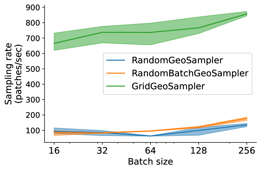
In Figure 3(a), we calculate the rate at which samples of varying batch size can be drawn from a GeoDataset using various GeoSampler implementations. Compared to the other samplers, GridGeoSampler is significantly faster due to the repeated access of samples that are already in GDAL’s least recently used (LRU) cache. For small batch sizes, RandomGeoSampler and RandomBatchGeoSampler are almost identical, since overlap between patches is uncommon. However, for larger batch sizes, RandomBatchGeoSampler starts to outperform RandomGeoSampler as the cache is used more effectively.
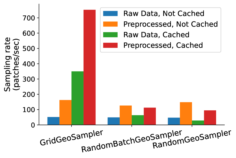
In Figure 3(b), we demonstrate the difference that preprocessing and caching data makes. This is most easily demonstrated by GridGeoSampler and to a lesser extent the other samplers. GDAL’s LRU cache only saves raw data loading times, so warping must always be done on the fly if the dataset CRSs or resolutions do not match. When the necessary storage is available, preprocessing the data ahead of time can lead to significantly faster sampling rates. Although RandomGeoSampler and RandomBatchGeoSampler are much slower than GridGeoSampler, most users will only need to use GridGeoSampler for inference due to our pre-trained model weights.
4.3. Dataset benchmarks
| Dataset | Method | Weight Initialization | Bands | Performance | |
| RESISC45 (Cheng et al., 2017) | ResNet50 | ImageNet | RGB | 95.42 0.23% | |
| ResNet18 | random | RGB | 79.90 0.25% | ||
| ResNet50 v2 (Neumann et al., 2019) | In domain | RGB | 96.86% | ||
| ViT B/16 (Steiner et al., 2021) | ImageNet-21k | RGB | 96.80% | ||
| ResNet50 (Zhai et al., 2019) | Sup-Rotation-100% | RGB | 96.30% | ||
| So2Sat (Zhu et al., 2019) | ResNet50 | ImageNet (+ random) | MSI | 63.99 1.38% | |
| ResNet50 | random | MSI | 56.82 4.32% | ||
| ResNet50 | ImageNet | RGB | 59.82 0.94% | ||
| ResNet50 | random | RGB | 49.46 2.67% | ||
| ResNeXt + CBAM (Zhu et al., 2019) | random | MSI | 61% | ||
| ResNet50 v2 (Neumann et al., 2019) | In domain | RGB | 63.25% | ||
| LandCover.ai (Boguszewski et al., 2021) | U-Net, ResNet50 encoder | ImageNet | RGB | 84.81 0.21% | |
| U-Net, ResNet50 encoder | random | RGB | 79.73 0.67% | ||
|
Cityscapes | RGB | 85.56% | ||
| Chesapeake Land Cover (Robinson et al., 2019) Delaware split | U-Net, ResNet50 encoder | ImageNet (+ random) | MSI | 69.40 1.39% | |
| U-Net, ResNet18 encoder | random | MSI | 68.99 0.84% | ||
| ETCI 2021 (NASA-IMPACT, 2021) | U-Net, ResNet50 encoder | random | SAR | 45.77 3.19% | |
| EuroSAT (Helber et al., 2019) | ResNet50 | ImageNet (+ random) | MSI | 97.86 0.23% | |
| ResNet50 | random | MSI | 96.07 0.28% | ||
| ResNet50 | ImageNet | RGB | 98.11 0.31% | ||
| ResNet50 | random | RGB | 87.33 0.76% | ||
| ResNet50 v2 (Neumann et al., 2019) | In domain | RGB | 99.20% | ||
| UC Merced (Yang and Newsam, 2010) | ResNet50 | ImageNet | RGB | 98.15% 0.46% | |
| ResNet50 v2 (Neumann et al., 2019) | In domain | RGB | 99.61% | ||
| COWC Counting (Mundhenk et al., 2016) | ResNet50 | ImageNet | RGB | 0.573 0.005 | |
| ResNet18 | ImageNet | RGB | 0.667 0.007 | ||
| ResCeption (Mundhenk et al., 2016) | random | RGB | 0.657 |
We also use TorchGeo to create simple, reproducible benchmark results on 8 of the datasets described in Section 4.1. We report the uncertainty in the results such that future work can evaluate whether a proposed improvement is due to methodological innovation or variance in results due to the stochastic nature of training deep learning models. To ensure reproducibility, we include a model training and evaluation framework in TorchGeo based around the PyTorch Lightning library and release all of our results. To quantify uncertainty, we report the mean and standard deviation metrics calculated over 10 training runs with different random seeds. The torchmetrics library (Borovec et al., 2020) was used to compute all performance values (overall top-1 accuracy for the classification datasets, mean intersection over union (mIoU) for the semantic segmentation datasets, and root mean square error (RMSE) for the regression dataset).
Our main results are shown in Table 3. We find that our simple training setup achieves competitive results on several datasets. The in-domain pre-training method in Neumann et al. (2019) trains models starting from ImageNet weights, then further trains on remote sensing (in domain) datasets, before fine-tuning on the actual target dataset, which performs better than simply starting from ImageNet weights. In contrast, our best result across the RESISC45, EuroSAT, and UC Merced datasets come from simply using ImageNet pre-trained models and training on the target dataset with a low learning rate. The difference between these approaches is likely entirely due to different learning rate selection in the hyperparameter search, and data augmentation in the in-domain pre-training setup. On the So2Sat dataset, we find that the ImageNet pre-trained models are able to achieve similar results as in-domain pretraining, but only when using all Sentinel-2 bands. The previously reported baseline methods on the LandCover.ai dataset all use a DeepLabV3+ segmentation model with a Xception71 + Dense Prediction Cell (DPC) encoder that has been pre-trained on Cityscapes. We are able to achieve a result within 0.75% mIoU of this setup using a simple U-Net and ResNet50 encoder pre-trained on ImageNet. Finally, we report the first set of basic benchmark results on the Chesapeake Land Cover dataset.
4.4. Effect of ImageNet pre-training on generalization performance
Two of the datasets we test with, So2Sat and Chesapeake Land Cover, contain splits that are designed to measure the generalization performance of a model. The validation and test splits from So2Sat include data from urban areas that are not included in the training split while the Chesapeake Land Cover dataset contains separate splits for six different states. In these settings, we observe a large performance boost when training models from ImageNet weights versus from a random initialization, however we do not observe the boost on in-domain data. Table 4 shows the performance of models that are trained on the Delaware split and evaluated on the test splits from every state. The in-domain performance (i.e., in Delaware) of the ImageNet pre-trained model and a model trained from scratch are the same, however, in every other setting the ImageNet pre-trained model performs better. In all cases but Maryland, this difference is greater than 6 points of mIoU with the most extreme difference being 12 points in Virginia. In the So2Sat case, we find that most models are not able to significantly reduce validation loss (where in this case validation data is out-of-domain), while, unsurprisingly, achieving near perfect results on the training data. Despite this overfitting, there remains a large gap between the best and worst models, with ImageNet pre-trained models achieving +7% and +10% accuracy over randomly initialized models. These results extend existing lines of research in computer vision that show how pre-training can improve out-of-domain performance (Hendrycks et al., 2019), and how, specifically, ImageNet pretraining is useful for transfer learning tasks (Huh et al., 2016).
| Weight init | Delaware | Maryland | New York | Pennsylvania | Virginia | West Virginia |
|---|---|---|---|---|---|---|
| ImageNet (+ random) | 69.40 1.39% | 59.57 0.70% | 57.95 1.10% | 55.13 1.25% | 45.56 1.54% | 20.76 1.95% |
| random | 68.99 0.84% | 57.30 0.78% | 49.26 2.40% | 47.67 2.40% | 33.14 3.73% | 14.95 2.72% |
5. Discussion
We introduce TorchGeo, a Python package for enabling deep learning with geospatial data. TorchGeo provides data loaders for common geospatial datasets, composable data loaders for uncurated geospatial raster and vector data, samplers appropriate for geospatial data, models pre-trained on satellite imagery, multispectral transforms, and model trainers. Importantly, TorchGeo allows users to bypass the common pre-processing steps necessary to align geospatial imagery with labels and performs this pre-processing on the fly. We benchmark TorchGeo data loader speed and demonstrate how TorchGeo can be used to create reproducible benchmark results in several geospatial datasets.
Finally, TorchGeo serves as a platform for performing geospatial machine learning research. Existing works in self-supervised learning with geospatial data rely on spatiotemporal metadata and can be naturally implemented in TorchGeo and scaled over large amounts of geospatial imagery without the need for pre-processing steps. Similarly, augmentation methods appropriate for training with geospatial imagery are under-explored, however, can be easily integrated with TorchGeo. Other interesting future research directions include building inductive biases appropriate for geospatial imagery into deep learning models (similar to the work done on rotation equivariant networks (Marcos et al., 2018)), data fusion techniques (e.g., how to incorporate spatial information into models, or appropriately use multi-modal layers), and learning shape-based models. Finally, TorchGeo exposes a catalog of benchmark geospatial datasets (Table 1) through a common interface, and, with the results in this paper, has begun to include corresponding benchmark results. This makes it easy for researchers to compare new ideas to existing work without having to repeat expensive computations. We hope TorchGeo can help drive advances at the intersection of machine learning and remote sensing.
Acknowledgements.
This research is part of the Blue Waters sustained-petascale computing project, which is supported by the National Science Foundation (awards OCI-0725070 and ACI-1238993), the State of Illinois, and as of December, 2019, the National Geospatial-Intelligence Agency. Blue Waters is a joint effort of the University of Illinois at Urbana-Champaign and its National Center for Supercomputing Applications. The research was supported by NSF grants IIS 21-31335, OAC 21-30835, DBI 20-21898, and a C3.ai research award. We’d like to thank TorchGeo contributors for their efforts in creating the library. We’d also like to thank Siyu Yang, Md Nasir, Shahrzad Gholami, and Thomas Roca for their feedback and support.References
- (1)
- Abrams et al. (2020) Michael Abrams, Robert Crippen, and Hiroyuki Fujisada. 2020. ASTER global digital elevation model (GDEM) and ASTER global water body dataset (ASTWBD). Remote Sensing 12, 7 (2020), 1156.
- AG (2021) Wingtra AG. 2021. WingtraOne mapping drone and Sony RX1R II camera. https://wingtra.com/mapping-drone-wingtraone/image-quality/
- Ayush et al. (2021) Kumar Ayush, Burak Uzkent, Chenlin Meng, Kumar Tanmay, Marshall Burke, David Lobell, and Stefano Ermon. 2021. Geography-aware self-supervised learning. In Proceedings of the IEEE/CVF International Conference on Computer Vision. 10181–10190.
- Baltrušaitis et al. (2019) Tadas Baltrušaitis, Chaitanya Ahuja, and Louis-Philippe Morency. 2019. Multimodal Machine Learning: A Survey and Taxonomy. IEEE Transactions on Pattern Analysis and Machine Intelligence 41, 2 (2019), 423–443. https://doi.org/10.1109/TPAMI.2018.2798607
- Bargeron and Moorhead (2007) Charles T Bargeron and David J Moorhead. 2007. EDDMapS—early detection and distribution mapping system for the southeast exotic pest plant council. Wildland weeds 10, 4 (2007), 4–8.
- Boguszewski et al. (2021) Adrian Boguszewski, Dominik Batorski, Natalia Ziemba-Jankowska, Tomasz Dziedzic, and Anna Zambrzycka. 2021. LandCover.ai: Dataset for Automatic Mapping of Buildings, Woodlands, Water and Roads From Aerial Imagery. In Proceedings of the IEEE/CVF Conference on Computer Vision and Pattern Recognition. 1102–1110.
- Borovec et al. (2020) Jirka Borovec et al. 2020. TorchMetrics: Machine learning metrics for distributed, scalable PyTorch applications. https://github.com/PyTorchLightning/metrics
- Boryan et al. (2011) Claire Boryan, Zhengwei Yang, Rick Mueller, and Mike Craig. 2011. Monitoring US agriculture: the US Department of Agriculture, National Agricultural Statistics Service, Cropland Data Layer Program. Geocarto International 26, 5 (2011), 341–358.
- Camps-Valls et al. (2021) Gustau Camps-Valls, Devis Tuia, Xiao Xiang Zhu, and Markus Reichstein. 2021. Deep learning for the Earth Sciences: A comprehensive approach to remote sensing, climate science and geosciences. John Wiley & Sons.
- Cheng et al. (2017) Gong Cheng, Junwei Han, and Xiaoqiang Lu. 2017. Remote Sensing Image Scene Classification: Benchmark and State of the Art. Proc. IEEE 105, 10 (2017), 1865–1883. https://doi.org/10.1109/JPROC.2017.2675998
- Cheng et al. (2014) Gong Cheng, Junwei Han, Peicheng Zhou, and Lei Guo. 2014. Multi-class geospatial object detection and geographic image classification based on collection of part detectors. ISPRS Journal of Photogrammetry and Remote Sensing 98 (2014), 119–132. https://doi.org/10.1016/j.isprsjprs.2014.10.002
- Clark et al. (2010) Alex Clark et al. 2010. Pillow: The friendly PIL fork (Python Imaging Library). https://github.com/python-pillow/Pillow
- Daudt et al. (2018a) Rodrigo Caye Daudt, Bertr Le Saux, and Alexandre Boulch. 2018a. Fully convolutional Siamese networks for change detection. In 2018 25th IEEE International Conference on Image Processing (ICIP). IEEE, 4063–4067.
- Daudt et al. (2018b) Rodrigo Caye Daudt, Bertr Le Saux, Alexandre Boulch, and Yann Gousseau. 2018b. Urban change detection for multispectral earth observation using convolutional neural networks. In IGARSS 2018-2018 IEEE International Geoscience and Remote Sensing Symposium. IEEE, 2115–2118.
- Deng et al. (2009) Jia Deng, Wei Dong, Richard Socher, Li-Jia Li, Kai Li, and Li Fei-Fei. 2009. ImageNet: A large-scale hierarchical image database. In 2009 IEEE conference on computer vision and pattern recognition. Ieee, 248–255.
- Drusch et al. (2012) Matthias Drusch, Umberto Del Bello, Sébastien Carlier, Olivier Colin, Veronica Fernandez, Ferran Gascon, Bianca Hoersch, Claudia Isola, Paolo Laberinti, Philippe Martimort, et al. 2012. Sentinel-2: ESA’s optical high-resolution mission for GMES operational services. Remote sensing of Environment 120 (2012), 25–36.
- Foundation (2020) Radiant Earth Foundation. 2020. CV4A Competition Kenya Crop Type Dataset. https://doi.org/10.34911/RDNT.DW605X Version 1.0, Radiant MLHub.
- (FSA) (2015) USDA Farm Service Agency (FSA). 2015. National Agriculture Imagery Program (NAIP). USDA Geospatial Data Gateway.
- GBIF (2020) GBIF. 2020. GBIF: The Global Biodiversity Information Facility. gbif.org
- GDAL/OGR contributors (2022) GDAL/OGR contributors. 2022. GDAL/OGR Geospatial Data Abstraction software Library. Open Source Geospatial Foundation. https://doi.org/10.5281/zenodo.5884351
- Graves et al. (2021) Sarah J. Graves, Sergio Marconi, Dylan Stewart, Ira Harmon, Ben G. Weinstein, Yuzi Kanazawa, Victoria M. Scholl, Maxwell B. Joseph, Joseph McClinchy, et al. 2021. Data science competition for cross-site delineation and classification of individual trees from airborne remote sensing data. bioRxiv (2021).
- Grill et al. (2020) Jean-Bastien Grill, Florian Strub, Florent Altché, Corentin Tallec, Pierre H Richemond, Elena Buchatskaya, Carl Doersch, Bernardo Avila Pires, Zhaohan Daniel Guo, et al. 2020. Bootstrap your own latent: A new approach to self-supervised learning. arXiv preprint arXiv:2006.07733 (2020).
- Gupta et al. (2019) Ritwik Gupta, Richard Hosfelt, Sandra Sajeev, Nirav Patel, Bryce Goodman, Jigar Doshi, Eric Heim, Howie Choset, and Matthew Gaston. 2019. xBD: A Dataset for Assessing Building Damage from Satellite Imagery. arXiv:1911.09296 [cs.CV]
- Helber et al. (2019) Patrick Helber, Benjamin Bischke, Andreas Dengel, and Damian Borth. 2019. EuroSAT: A novel dataset and deep learning benchmark for land use and land cover classification. IEEE Journal of Selected Topics in Applied Earth Observations and Remote Sensing 12, 7 (2019), 2217–2226.
- Hendrycks et al. (2019) Dan Hendrycks, Kimin Lee, and Mantas Mazeika. 2019. Using pre-training can improve model robustness and uncertainty. In International Conference on Machine Learning. PMLR, 2712–2721.
- Hu et al. (2020) Di Hu, Xuhong Li, Lichao Mou, Pu Jin, Dong Chen, Liping Jing, Xiaoxiang Zhu, and Dejing Dou. 2020. Cross-Task Transfer for Geotagged Audiovisual Aerial Scene Recognition. In Computer Vision – ECCV 2020, Andrea Vedaldi, Horst Bischof, Thomas Brox, and Jan-Michael Frahm (Eds.). Springer International Publishing, Cham, 68–84.
- Huh et al. (2016) Minyoung Huh, Pulkit Agrawal, and Alexei A Efros. 2016. What makes ImageNet good for transfer learning? arXiv preprint arXiv:1608.08614 (2016).
- Jean et al. (2019) Neal Jean, Sherrie Wang, Anshul Samar, George Azzari, David Lobell, and Stefano Ermon. 2019. Tile2Vec: Unsupervised representation learning for spatially distributed data. In Proceedings of the AAAI Conference on Artificial Intelligence, Vol. 33. 3967–3974.
- Jin et al. (2021) Z. Jin, C. Lin, C. Weigl, J. Obarowski, and D. Hale. 2021. Smallholder Cashew Plantations in Benin. https://doi.org/10.34911/rdnt.hfv20i Radiant MLHub.
- Karra et al. (2021a) Krishna Karra, Caitlin Kontgis, Zoe Statman-Weil, Joseph C. Mazzariello, Mark Mathis, and Steven P. Brumby. 2021a. Global land use / land cover with Sentinel 2 and deep learning. In 2021 IEEE International Geoscience and Remote Sensing Symposium IGARSS. 4704–4707. https://doi.org/10.1109/IGARSS47720.2021.9553499
- Karra et al. (2021b) Krishna Karra, Caitlin Kontgis, Zoe Statman-Weil, Joseph C Mazzariello, Mark Mathis, and Steven P Brumby. 2021b. Global land use/land cover with Sentinel 2 and deep learning. In 2021 IEEE International Geoscience and Remote Sensing Symposium IGARSS. IEEE, 4704–4707.
- Liu et al. (2018) Chenxi Liu, Barret Zoph, Maxim Neumann, Jonathon Shlens, Wei Hua, Li-Jia Li, Li Fei-Fei, Alan Yuille, Jonathan Huang, and Kevin Murphy. 2018. Progressive neural architecture search. In Proceedings of the European conference on computer vision (ECCV). 19–34.
- Loshchilov and Hutter (2017) Ilya Loshchilov and Frank Hutter. 2017. Decoupled weight decay regularization. arXiv preprint arXiv:1711.05101 (2017).
- Lu et al. (2016) Dengsheng Lu, Qi Chen, Guangxing Wang, Lijuan Liu, Guiying Li, and Emilio Moran. 2016. A survey of remote sensing-based aboveground biomass estimation methods in forest ecosystems. International Journal of Digital Earth 9, 1 (2016), 63–105.
- Mañas et al. (2021) Oscar Mañas, Alexandre Lacoste, Xavier Giro-i Nieto, David Vazquez, and Pau Rodriguez. 2021. Seasonal Contrast: Unsupervised Pre-Training from Uncurated Remote Sensing Data. arXiv preprint arXiv:2103.16607 (2021).
- Marcos et al. (2018) Diego Marcos, Michele Volpi, Benjamin Kellenberger, and Devis Tuia. 2018. Land cover mapping at very high resolution with rotation equivariant CNNs: Towards small yet accurate models. ISPRS Journal of Photogrammetry and Remote Sensing 145 (2018), 96–107.
- Maskey et al. (2020) Manil Maskey, Rahul Ramachandran, Muthukumaran Ramasubramanian, Iksha Gurung, Brian Freitag, Aaron Kaulfus, Drew Bollinger, Daniel J. Cecil, and Jeffrey Miller. 2020. Deepti: Deep-Learning-Based Tropical Cyclone Intensity Estimation System. IEEE Journal of Selected Topics in Applied Earth Observations and Remote Sensing 13 (2020), 4271–4281. https://doi.org/10.1109/JSTARS.2020.3011907
- Massa et al. (2016) Francisco Massa et al. 2016. torchvision: Datasets, Transforms and Models specific to Computer Vision. https://github.com/pytorch/vision
- Mulla (2013) David J. Mulla. 2013. Twenty five years of remote sensing in precision agriculture: Key advances and remaining knowledge gaps. Biosystems Engineering 114, 4 (2013), 358–371. https://doi.org/10.1016/j.biosystemseng.2012.08.009 Special Issue: Sensing Technologies for Sustainable Agriculture.
- Mundhenk et al. (2016) T Nathan Mundhenk, Goran Konjevod, Wesam A Sakla, and Kofi Boakye. 2016. A large contextual dataset for classification, detection and counting of cars with deep learning. In European Conference on Computer Vision. Springer, 785–800.
- NASA-IMPACT (2021) NASA-IMPACT. 2021. ETCI 2021 Competition on Flood Detection. https://nasa-impact.github.io/etci2021/
- Neumann et al. (2019) Maxim Neumann, Andre Susano Pinto, Xiaohua Zhai, and Neil Houlsby. 2019. In-domain representation learning for remote sensing. arXiv preprint arXiv:1911.06721 (2019).
- of Satellite and Operations (1994) NOAA Office of Satellite and Product Operations. 1994. NOAA Geostationary Operational Environmental Satellite (GOES) I-M and N-P Series Imager Data. NOAA National Centers for Environmental Information. https://doi.org/10.25921/Z9JQ-K976
- Pearlman et al. (2003) Jay S Pearlman, Pamela S Barry, Carol C Segal, John Shepanski, Debra Beiso, and Stephen L Carman. 2003. Hyperion, a space-based imaging spectrometer. IEEE Transactions on Geoscience and Remote Sensing 41, 6 (2003), 1160–1173.
- Riba et al. (2020) Edgar Riba, Dmytro Mishkin, Daniel Ponsa, Ethan Rublee, and Gary Bradski. 2020. Kornia: an open source differentiable computer vision library for PyTorch. In Proceedings of the IEEE/CVF Winter Conference on Applications of Computer Vision. 3674–3683.
- Robinson et al. (2019) Caleb Robinson, Le Hou, Kolya Malkin, Rachel Soobitsky, Jacob Czawlytko, Bistra Dilkina, and Nebojsa Jojic. 2019. Large Scale High-Resolution Land Cover Mapping With Multi-Resolution Data. In Proceedings of the IEEE Conference on Computer Vision and Pattern Recognition. 12726–12735.
- Rogan et al. (2008) John Rogan, Janet Franklin, Doug Stow, Jennifer Miller, Curtis Woodcock, and Dar Roberts. 2008. Mapping land-cover modifications over large areas: A comparison of machine learning algorithms. Remote Sensing of Environment 112, 5 (2008), 2272–2283.
- Rolf et al. (2021a) Esther Rolf, Nikolay Malkin, Alexandros Graikos, Ana Jojic, Caleb Robinson, and Nebojsa Jojic. 2021a. Resolving label uncertainty with implicit generative models. (2021).
- Rolf et al. (2021b) Esther Rolf, Jonathan Proctor, Tamma Carleton, Ian Bolliger, Vaishaal Shankar, Miyabi Ishihara, Benjamin Recht, and Solomon Hsiang. 2021b. A generalizable and accessible approach to machine learning with global satellite imagery. Nature communications 12, 1 (2021), 1–11.
- Rolnick et al. (2019) David Rolnick, Priya L Donti, Lynn H Kaack, Kelly Kochanski, Alexandre Lacoste, Kris Sankaran, Andrew Slavin Ross, Nikola Milojevic-Dupont, Natasha Jaques, Anna Waldman-Brown, et al. 2019. Tackling climate change with machine learning. arXiv preprint arXiv:1906.05433 (2019).
- Rottensteiner et al. (2012) Franz Rottensteiner, Gunho Sohn, Jaewook Jung, Markus Gerke, Caroline Baillard, Sebastien Benitez, and Uwe Breitkopf. 2012. The ISPRS benchmark on urban object classification and 3D building reconstruction. ISPRS Annals of the Photogrammetry, Remote Sensing and Spatial Information Sciences I-3 (2012), Nr. 1 1, 1 (2012), 293–298.
- Roy et al. (2014) David P Roy, Michael A Wulder, Thomas R Loveland, Curtis E Woodcock, Richard G Allen, Martha C Anderson, Dennis Helder, James R Irons, David M Johnson, Robert Kennedy, et al. 2014. Landsat-8: Science and product vision for terrestrial global change research. Remote sensing of Environment 145 (2014), 154–172.
- Santoro (2018) Maurizio Santoro. 2018. GlobBiomass - global datasets of forest biomass. https://doi.org/10.1594/PANGAEA.894711
- Schmitt et al. (2019) Michael Schmitt, Lloyd Haydn Hughes, Chunping Qiu, and Xiao Xiang Zhu. 2019. SEN12MS–A Curated Dataset of Georeferenced Multi-Spectral Sentinel-1/2 Imagery for Deep Learning and Data Fusion. arXiv preprint arXiv:1906.07789 (2019).
- Shen et al. (2021) Li Shen, Yao Lu, Hao Chen, Hao Wei, Donghai Xie, Jiabao Yue, Rui Chen, Yue Zhang, Ao Zhang, Shouye Lv, et al. 2021. S2Looking: A Satellite Side-Looking Dataset for Building Change Detection. arXiv preprint arXiv:2107.09244 (2021).
- Simard et al. (2019) M. Simard, T. Fatoyinbo, C. Smetanka, V. H. Rivera-Monroy, E. Castaneda-Mova, N. Thomas, and T. Van der Stocken. 2019. Global Mangrove Distribution, Aboveground Biomass, and Canopy Height. https://doi.org/10.3334/ORNLDAAC/1665
- Sirko et al. (2021) Wojciech Sirko, Sergii Kashubin, Marvin Ritter, Abigail Annkah, Yasser Salah Eddine Bouchareb, Yann Dauphin, Daniel Keysers, Maxim Neumann, Moustapha Cisse, and John Quinn. 2021. Continental-scale building detection from high resolution satellite imagery. arXiv preprint arXiv:2107.12283 (2021).
- Steiner et al. (2021) Andreas Steiner, Alexander Kolesnikov, Xiaohua Zhai, Ross Wightman, Jakob Uszkoreit, and Lucas Beyer. 2021. How to train your ViT? Data, Augmentation, and Regularization in Vision Transformers. arXiv preprint arXiv:2106.10270 (2021).
- Sumbul et al. (2019) Gencer Sumbul, Marcela Charfuelan, Begüm Demir, and Volker Markl. 2019. Bigearthnet: A Large-Scale Benchmark Archive for Remote Sensing Image Understanding. In IGARSS 2019 - 2019 IEEE International Geoscience and Remote Sensing Symposium. 5901–5904. https://doi.org/10.1109/IGARSS.2019.8900532
- Sumisu (2019) Timu Sumisu. 2019. Canadian Building Footprints. https://github.com/microsoft/CanadianBuildingFootprints
- Sun et al. (2021) Xian Sun, Peijin Wang, Zhiyuan Yan, Feng Xu, Ruiping Wang, Wenhui Diao, Jin Chen, Jihao Li, Yingchao Feng, Tao Xu, Martin Weinmann, Stefan Hinz, Cheng Wang, and Kun Fu. 2021. FAIR1M: A Benchmark Dataset for Fine-grained Object Recognition in High-Resolution Remote Sensing Imagery.
- Technologies (2021) Maxar Technologies. 2021. WorldView satellite imagery.
- Tong et al. (2020) Xin-Yi Tong, Gui-Song Xia, Qikai Lu, Huanfeng Shen, Shengyang Li, Shucheng You, and Liangpei Zhang. 2020. Land-cover classification with high-resolution remote sensing images using transferable deep models. Remote Sensing of Environment 237 (2020), 111322.
- Turkoglu et al. (2021) Mehmet Ozgur Turkoglu, Stefano D’Aronco, Gregor Perich, Frank Liebisch, Constantin Streit, Konrad Schindler, and Jan Dirk Wegner. 2021. Crop mapping from image time series: deep learning with multi-scale label hierarchies. arXiv preprint arXiv:2102.08820 (2021).
- Van Etten et al. (2018) Adam Van Etten, Dave Lindenbaum, and Todd M Bacastow. 2018. SpaceNet: A remote sensing dataset and challenge series. arXiv preprint arXiv:1807.01232 (2018).
- Van Westen (2013) Cees J Van Westen. 2013. Remote sensing and GIS for natural hazards assessment and disaster risk management. Treatise on geomorphology 3 (2013), 259–298.
- Watch (2002) Global Forest Watch. 2002. Global forest watch. World Resources Institute, Washington, DC Available from http://www. globalforestwatch. org (accessed March 2002) (2002).
- William and The PyTorch Lightning team (2019) Falcon William and The PyTorch Lightning team. 2019. PyTorch Lightning. https://doi.org/10.5281/zenodo.3828935
- Yang and Newsam (2010) Yi Yang and Shawn Newsam. 2010. Bag-of-visual-words and spatial extensions for land-use classification. In Proceedings of the 18th SIGSPATIAL international conference on advances in geographic information systems. 270–279.
- Yang et al. (2021) Yao-Yuan Yang, Moto Hira, Zhaoheng Ni, Anjali Chourdia, Artyom Astafurov, Caroline Chen, Ching-Feng Yeh, Christian Puhrsch, David Pollack, Dmitriy Genzel, Donny Greenberg, Edward Z. Yang, Jason Lian, Jay Mahadeokar, Jeff Hwang, Ji Chen, Peter Goldsborough, Prabhat Roy, Sean Narenthiran, Shinji Watanabe, Soumith Chintala, Vincent Quenneville-Bélair, and Yangyang Shi. 2021. TorchAudio: Building Blocks for Audio and Speech Processing. arXiv preprint arXiv:2110.15018 (2021).
- Yosinski et al. (2014) Jason Yosinski, Jeff Clune, Yoshua Bengio, and Hod Lipson. 2014. How transferable are features in deep neural networks? arXiv preprint arXiv:1411.1792 (2014).
- Zhai et al. (2019) Xiaohua Zhai, Joan Puigcerver, Alexander Kolesnikov, Pierre Ruyssen, Carlos Riquelme, Mario Lucic, Josip Djolonga, Andre Susano Pinto, Maxim Neumann, Alexey Dosovitskiy, et al. 2019. A large-scale study of representation learning with the visual task adaptation benchmark. arXiv preprint arXiv:1910.04867 (2019).
- Zhang et al. (2016) Guanheng Zhang et al. 2016. torchtext: Data loaders and abstractions for text and NLP. https://github.com/pytorch/text
- Zhang (2010) Jixian Zhang. 2010. Multi-source remote sensing data fusion: status and trends. International Journal of Image and Data Fusion 1, 1 (2010), 5–24.
- Zhang et al. (2019) Wei Zhang, Ping Tang, and Lijun Zhao. 2019. Remote sensing image scene classification using CNN-CapsNet. Remote Sensing 11, 5 (2019), 494.
- Zhou et al. (2018) Weixun Zhou, Shawn Newsam, Congmin Li, and Zhenfeng Shao. 2018. PatternNet: A benchmark dataset for performance evaluation of remote sensing image retrieval. ISPRS Journal of Photogrammetry and Remote Sensing 145 (2018), 197–209.
- Zhu et al. (2019) Xiao Xiang Zhu, Jingliang Hu, Chunping Qiu, Yilei Shi, Jian Kang, Lichao Mou, Hossein Bagheri, Matthias Häberle, Yuansheng Hua, Rong Huang, et al. 2019. So2Sat LCZ42: A benchmark dataset for global local climate zones classification. arXiv preprint arXiv:1912.12171 (2019).
Appendix A Data loader benchmarking
In order to benchmark the performance of our data loaders, we download 114 Landsat 8 collection 2 level-2 scenes and 1 Cropland Data Layer (CDL) file for the year of 2019. All files are stored as Cloud Optimized GeoTIFFs (COGs) with a block size of 512, and take up 151 GB of space on disk, uncompressed. All files are kept in their original CRS (Albers Equal Area for CDL and UTM for Landsat). Experiments are run on Microsoft Azure with a 6-core Intel Xeon E5-2690 CPU. All data is stored on a local SSD attached to the compute node. Batch size and random seed are varied while the remaining hyperparameters are kept fixed. Total epoch size is 4096, patch size is 224, stride is 112, and the number of workers for parallel data loading is set to 6.
Appendix B Pre-processing alignment with GDAL
As an example of an alignment pre-processing workflow, we assume that we have a Landsat 8 scene and a Cropland Data Layer (CDL) raster (“cdl.tif”) which completely covers the extent of the Landsat scene. We would like to create a pixel-aligned version of these two layers. Given that the Landsat 8 scene has a CRS of “EPSG:32619”, a height of 8011 pixels, a width of 7891 pixels, and spatial bounds of (186585, 4505085, 423315, 4745415), the corresponding GDAL command to create a cropped version of the CDL layer that is aligned to the Landsat layer would look like:
The spatial metadata of the Landsat scene can be determined through other GDAL command-line tools (gdalinfo command), geospatial data packages such as the rasterio package in Python, or through GIS software such as QGIS or ArcGIS.
Appendix C TorchGeo code example
TorchGeo is designed to be simple and easy to use, and provides a familiar API for users who have experience using libraries like torchvision (Massa et al., 2016). In Listing 2, we provide an example code snippet showing how to use TorchGeo.
In this example, we show how easy it is to work with geospatial data and to sample small image patches from a combination of Landsat (Roy et al., 2014) and Cropland Data Layer (CDL) (Boryan et al., 2011) data using TorchGeo. First, we assume that the user has Landsat 7 and 8 imagery downloaded. Since Landsat 8 has more spectral bands than Landsat 7, we only use the bands that both satellites have in common. We create a single dataset including all images from both Landsat 7 and 8 data by taking the union between these two datasets.
Next, we take the intersection between this dataset and the CDL dataset. We want to take the intersection instead of the union to ensure that we only sample from regions where we have both Landsat and CDL data. Note that we can automatically download and checksum CDL data. Also note that each of these datasets may contain files in different CRSs or resolutions, but TorchGeo automatically ensures that a matching CRS and resolution is used.
This dataset can now be used with a PyTorch data loader. Unlike benchmark datasets, geospatial datasets often include very large images. For example, the CDL dataset consists of a single image covering the entire contiguous United States. In order to sample from these datasets using geospatial coordinates, TorchGeo defines a number of samplers. In this example, we use a random sampler that returns pixel images and 10,000 samples per epoch. We also use a custom collation function to combine each sample dictionary into a mini-batch of samples. This data loader can now be used in your normal training/evaluation pipeline.
Many applications involve intelligently composing datasets based on geospatial metadata like this. For example, users may want to:
-
•
Combine datasets for multiple image sources and treat them as equivalent (e.g., Landsat 7 and 8)
-
•
Combine datasets for disparate geospatial locations (e.g., Chesapeake NY and PA)
These combinations require that all queries are present in at least one dataset, and can be created using a UnionDataset. Similarly, users may want to:
-
•
Combine image and target labels and sample from both simultaneously (e.g., Landsat and CDL)
-
•
Combine datasets for multiple images sources for multimodal learning or data fusion (e.g., Landsat and Sentinel)
These combinations require that all queries are present in both datasets, and can be created using an IntersectionDataset. TorchGeo automatically composes these datasets for you when you use the intersection (&) and union (|) operators.
Appendix D Benchmark dataset experiments
For experiments, we use the pre-defined training, validation, and testing splits in all datasets. We perform a small hyperparameter search with a single fixed random seed on each dataset. Specifically, we perform a hyperparameter search for the best validation performance over the grid: model architecture {ResNet18, ResNet50}, weight initialization {random, ImageNet}, learning rate {0.01, 0.001, 0.0001}, and loss function {cross entropy, jaccard}. For the classification and regression datasets, we use the ResNets as is, and for the semantic segmentation datasets, we use the ResNets as the encoder model in a U-Net. With the So2Sat and EuroSAT datasets we also run experiments that use all the Sentinel-2 bands vs. only the RGB bands. In the cases where we use ImageNet weights with imagery that has more than RGB bands we randomly initialize the non-RGB kernels in the first convolutional layer of the network and denote this setting as ImageNet (+ random). In all cases, we use the AdamW optimizer (Loshchilov and Hutter, 2017), reduce learning rate on validation loss plateaus, and early stop based on validation loss. We repeat the training process with 10 different seeds using the best performing hyperparameter configuration and report the test set performance over these models.