A Survey of Wireless Networks for Future Aerial COMmunications (FACOM)
††thanks: A. Baltaci and D. Schupke are with Airbus, Central Research and Technology, Taufkirchen, 82024 Germany. A. Baltaci is also with Technical University of Munich, Department of Informatics, Garching, 85748, Germany. (email: ayguen.baltaci@airbus.com; dominic.schupke@airbus.com).
E. Dinc is currently with the Cavendish Laboratory, University of Cambridge, CB3 0HE, UK. During the time of this study, he was a postdoc at KTH Royal Institute of Technology, Stockholm 164 40, Sweden. (e-mail: ed502@cam.ac.uk).
M. Ozger and C. Cavdar are with the School of Electrical Engineering and Computer Science, KTH Royal Institute of Technology, Stockholm 164 40, Sweden. (email: ozger@kth.se; cavdar@kth.se).
A. Alabbasi is with Ericsson. (e-mail: abdulrahman.alabbasi@ericsson.com).
Abstract
Electrification turned over a new leaf in aviation by introducing new types of aerial vehicles along with new means of transportation. Addressing a plethora of use cases, drones are gaining attention in the industry and increasingly appear in the sky. Emerging concepts of flying taxi enable passengers to be transported over several tens of kilometers. Therefore, unmanned traffic management systems are under development to cope with the complexity of future airspace, thereby resulting in unprecedented communication needs. Moreover, the long-term increase in the number of commercial airplanes pushes the limits of voice-oriented communications, and future options such as single-pilot operations demand robust connectivity. In this survey, we provide a comprehensive review and vision for enabling the connectivity applications of aerial vehicles utilizing current and future communication technologies. We begin by categorizing the connectivity use cases per aerial vehicle and analyzing their connectivity requirements. By reviewing more than 500 related studies, we aim for a comprehensive approach to cover wireless communication technologies, and provide an overview of recent findings from the literature toward the possibilities and challenges of employing the wireless communication standards. After analyzing the proposed network architectures, we list the open-source testbed platforms to facilitate future investigations by researchers. This study helped us observe that while numerous works focused on cellular technologies to enable connectivity for aerial platforms, a single wireless technology is not sufficient to meet the stringent connectivity demands of the aerial use cases, especially for the piloting operations. We identified the need of further investigations on multi-technology heterogeneous network architectures to enable robust and real-time connectivity in the sky. Future works should consider suitable technology combinations to develop unified aerial networks that can meet the diverse quality of service demands of the aerial use cases.
Index Terms:
Aerial communications, aerial network architectures, aerial use-cases, aerial simulators, cellular networks, Control and Non-payload Communicatiosn (CNPC), drone, Electrical Vertical Take-off and Landing (eVTOL), flying taxi, High Altitude Platform (HAP), Unmanned Aerial Vehicle (UAV), Unmanned Traffic Management (UTM).I Introduction
Recent advances in the aviation industry toward electrified Aerial Vehicles (AVs) have led to carbon dioxide-friendly and cost-efficient concepts for aerial transportation. While Unmanned Aerial Vehicles (UAVs) introduced a variety of aerial applications such as surveillance and disaster relief [1], emerging Electrical Vertical Take-off and Landing (eVTOL) vehicles are making urban aerial passenger transportation into a reality. The concept of Urban Air Mobility (UAM) comprises these looming operations of eVTOLs and UAVs. Furthermore, the increasing demands of international passenger travel push the limits of the current communication capacity of commercial airplanes [2]. These concepts captivate business players, and hence, the airspace operations are undergoing an evolution to handle the coexistence of all the emerging aerial use cases.
As the number and variety of AVs increase, several challenges need to be addressed to ensure safe operations in the sky. The AVs should coordinate with each other to share the airspace efficiently. In this regard, we observe the introduction of Unmanned Traffic Management (UTM) to bring digitalization and regulation of air traffic in the low-altitude airspace [3]. Besides, the safety-oriented nature of aviation imposes challenging certification requirements to ensure the airworthiness of AVs [4]. As connectivity has a vital role in the operations of emerging AVs, it emphasizes the demand for resilient connectivity hardware, robust connectivity links as well as the use of aviation safety spectrum in particular applications.
AVs have different vehicle and flight characteristics as well as diverse connectivity use cases inducing heterogeneity in Quality of Service (QoS) requirements such as end-to-end data rate, latency and communication reliability. Although we can consider Direct Air-to-ground Communication (DA2GC) systems using existing terrestrial network infrastructures to provide connectivity for UAVs at low altitudes, DA2GC for airplanes at an altitude of approximately 10 km requires sophisticated architectures to provide coverage. Moreover, Remote Piloting Operations (RPOs) of the AVs requires real-time and very reliable connectivity to ensure safe operations, which is challenging for the state-of-the-art connectivity technologies. Most of the current RPOs of UAVs take place with the Wireless Fidelity (WiFi) technology due to hardware availability and cost-efficiency [5]. However, the limited range of WiFi prevents its use in Beyond Visual Line-of-sight (BVLoS) applications.
Emerging digital communication between airplanes and Air Traffic Management (ATM) entities has introduced new Internet Protocol (IP)-based solutions instead of the conventional analog voice connectivity [6].
| Notation | Description | Notation | Description |
| 3GPP | 3rd Generation for Mobile Communication | MANET | Internet of Things |
| A2A | Air-to-air | MEC | Internet of Things |
| A2G | Air-to-ground | MEO | Medium Earth Orbit |
| ACARS | Aircraft Communication Addressing and Reporting System | MIMO | Multiple-input Multiple-output |
| ACAS | Airborne Collision Avoidance System | mMTC | Massive Machine Type Communication |
| ADS-B | Automatic Dependent Surveillance Broadcasting | mmWave | Milli-meter Wave |
| AeroMACS | Airport Communication System | MNO | Mobile Network Operator |
| AI | Artificial Inteligence | MPTCP | Multipath Transmission Control Protocol |
| AMHS | Air Traffic Services Message Handling System | MTC | Machine Type Communications |
| AMSS | Aeronautical Mobile-Satellite Service | MTOM | Maximum Take-Off Mass |
| ATM | Air Traffic Management | MU-MIMO | Multi-user Multiple-input Multiple-output |
| AV | Aerial Vehicle | NASA | National Aeronautics and Space Administration |
| BS | Base Station | NB-IoT | Narrow-band Internet of Things |
| BVLoS | Beyond Visual Line-of-sight | NGMN | Next Generation Mobile Networks |
| C-V2V | Cellular Vehicle-to-vehicle Communication | OFDM | Orthogonal Frequency Division Multiplexing |
| C2 | Command and Control | OLDI | On-line Data Interchange |
| CGC | Complementary Ground Component | PER | Packet Error Ratio |
| CNPC | Control and Non-payload Communication | QAM | Quadrature Amplitude Modulation |
| CoMP | Coordinated Multipoint | QoS | Quality of Service |
| CTOL | Conventional Take-off and Landing | RAS | Radio Astronomy Services |
| DA2GC | Direct Air-to-ground Communication | RF | Radio Frequency |
| DAA | Detect and Avoid | RL | Reinforcement Learning |
| DAL | Development Assurance Level | RPAS | Remotely Piloted Aircraft System |
| EAN | European Aviation Network | RPO | Remote Piloting Operation |
| EASA | European Union Aviation Safety Agency | RSRP | Reference Signal Received Power |
| ECC | Electronic Communications Committee | RTCA | Radio Technical Commission for Aeronautics |
| EL | Egress Link | RTP | Real Time Protocol |
| eMBB | Enhanced Mobile Broadband | RTT | Round-trip Time |
| EUROCAE | European Organisation for Civil Aviation Equipment | SatCom | Satellite Communication |
| eVTOL | Electrical Vertical Take-off and Landing | SDN | Software-defined Networking |
| FAA | US Federal Aviation Administration | SDR | Software-defined Radio |
| FACOM | Future Aerial Communications | SINR | Signal-to-interference-and-noise Ratio |
| FANET | Flying Ad-hoc Network | SIR | Signal-to-interference Ratio |
| FAO | Fully Autonomous Operation | SNR | Signal-to-noise Ratio |
| FMTP | Flight Message Transfer Protocol | SPO | Single Pilot Operation |
| FSS | Fixed-Satellite Services | STDMA | Spatial Time Division Multiple Access |
| GEO | Geostationary Earth Orbit | SWaP | Size, Weight and Power |
| GPS | Global Position System | SWIM | System Wide Information Management |
| HAP | High Altitude Platform | TCP | Transmission Control Protocol |
| HAPCom | High Altitude Platform Communications | TDD | Time Division Duplexing |
| HTS | High Throughput Satellite | TP | Trajectory Planning |
| ICAO | International Civil Aviation Organization | U2X | UAV-to-everything |
| ICIC | Inter-Cell Interference Coordination | UAM | Urban Air Mobility |
| IETF | Internet Engineering Task Force | UAS | Unmanned Aircraft System |
| IFEC | In-flight Entertainment and Communications | UAV | Unmanned Aerial Vehicle |
| IL | Ingress Link | UDP | User Datagram Protocol |
| IMU | Inertial Measurement Unit | UE | User Equipment |
| IoT | Internet of Things | uRLLC | Ultra-reliable Low-latency Communication |
| IP | Internet Protocol | UTM | Unmanned Traffic Management |
| IRS | Intelligent Reflecting Surface | UWB | Ultra-wideband |
| ISL | Inter-satellite Link | V2X | Vehicle-to-everything |
| ITU | International Telecommunication Union | VDL-2 | VHF Datalink-2 |
| LAA | License Assisted Access | VHF | Very High Frequency |
| LDACS | L-band Digital Aeronautical Communications System | VLoS | Visual Line-of-sight |
| LEO | Low Earth Orbit | VoIP | Voice over IP |
| LIDAR | Light Detection And Ranging | WAIC | Wireless Avionics Intra-communications |
| LiFi | Light-Fidelity | WiFi | Wireless Fidelity |
| LoRa | Long Range | WiMAX | Worldwide Interoperability for Microwave Access |
| LoS | Line-of-sight | WSN | Wireless Sensor Network |
| MAC | Medium Access Control |
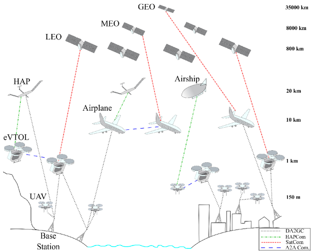
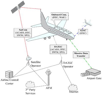
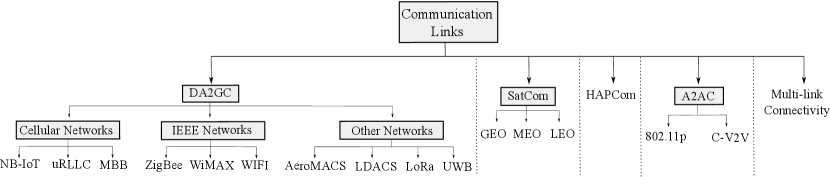
Future Single Pilot Operation (SPO) of airplanes requires robust connectivity to enable cooperation between onboard and ground operators [7]. All these applications of AVs pose a diverse range of connectivity requirements. This challenge requires a holistic approach, considering all the connectivity technologies, to enable the diverse aerial use cases in the sky. We should evaluate the capabilities of different connectivity platforms such as DA2GC, Satellite Communication (SatCom), High Altitude Platform Communications (HAPCom) and Air-to-air (A2A), as shown in figure 1. Therefore, in our study, we introduce the term, Future Aerial Communications (FACOM), as the connectivity ecosystem that incorporates all these looming aerial connectivity use cases and their potential connectivity solutions.
FACOM services have significant demands from the industry due to emerging business markets. Hence, FACOM can become a remarkable venture for communication operators, particularly with the increasing number of UAVs in the near future. In this regard, connectivity technologies are under development to provide services for the FACOM use cases.
The 3rd Generation for Mobile Communication (3GPP) standardization body includes non-terrestrial networks as part of the future 5G architectures [8, 9, 10, 11, 12, 13], and embraces Machine Type Communications (MTC) along with its conventional human-centric networks [14, 15]. Meanwhile, emerging satellite networks pave the way for high capacity and robust communication on a global scale. Low Earth Orbit (LEO) constellations promote cost-efficient and real-time connectivity over satellites [16, 17]. Moreover, future IEEE standards adopt more flexible and reliable architectures to widen its deployment in different application scenarios [18, 19, 20].
| Communication Reliability | Range |
| Low | % |
| Medium | % - % |
| High | % |
We need to evaluate the capabilities of each technology to determine its feasibility for future applications in the sky. For instance, although Geostationary Earth Orbit (GEO) constellations can provide wide coverage and reliable connectivity, they are unsuitable for latency-sensitive applications. Instead, upcoming LEO constellations and HAPCom promote real-time connectivity solutions, where the service interruption due to rapid handovers poses another challenge. In addition, coverage of DA2GC is primarily limited to flights over the ground, and A2A communication requires a certain extent of vehicle proximity to ensure end-to-end connectivity. Therefore, we analyze the advantages and drawbacks of each communication technology individually with respect to the QoS requirements of the aerial use cases, and determine the suitable matches.
In this paper, we aim to provide a comprehensive overview of the connectivity use cases of AVs, their connectivity demands, and potential connectivity solutions to realize FACOM. We focus on the Radio Frequency (RF) wireless technologies for non-military AVs, excluding wired as well as optical connectivity solutions. We only cover the external communication of AVs, leaving the onboard communication such as In-flight Entertainment and Communications (IFEC) and Wireless Avionics Intra-communications (WAIC) outside the scope of this survey. In addition, we study the external communication that take place from take-off until landing. The types of communication while an AV is on the ground, e.g., at the airport or under maintenance, are also outside the scope.
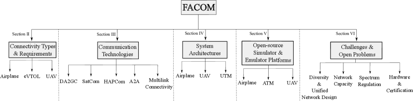
We begin with categorizing the use cases per type of AVs, and specify their connectivity demands and challenges from the aviation perspective. As concepts of flying taxis are of the recent venture, the literature has, to our best knowledge, not yet covered the connectivity needs and potential solutions for these platforms. Thus, we also provide our vision toward the future connectivity demands of eVTOLs. Afterward, we investigate the literature to evaluate the capabilities of available and near-future communication technologies with respect to the connectivity demands of FACOM use cases. We present a broad survey by analyzing more than 500 papers and discussing the solutions provided in the literature as well as open research questions. Based on the networking capabilities of each connectivity technology, we provide our match study presenting suitable technologies with respect to the QoS demands of the use cases. After analyzing potential heterogeneous multi-connectivity solutions for robust remote piloting operations, we review the proposed FACOM network and 5G system architectures in the literature. We also provide a comprehensive list of the open-source flight and networking testbed platforms that can facilitate future investigations toward the realization of FACOM. Finally, we conclude by summarizing the key findings and open challenges for future studies. We illustrate the outline of this survey in figure 2.
The rest of this paper is organized as follows. In section II, we provide a background on the FACOM use cases and their connectivity requirements. Thereafter, we present a literature survey regarding the potentials and challenges of the current wireless technologies for FACOM in section III. We demonstrate the proposed network and 5G system architectures in section IV. We also provide a list of open-source flight and network testbeds in section V. Finally, we discuss the open challenges in section VI and present the conclusions in section VII.
I-A Nomenclature and Definitions
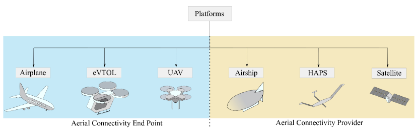
We categorize the aerial platforms based on their relation to the connectivity, as shown in figure 3. Airplanes and UAVs can also play a role in providing connectivity [22, 23]. However, such concepts are beyond the scope of this study since they deserve an own survey. Consequently, we do not cover the studies related to aerial Base Station (BS) in our literature review. Furthermore, High Altitude Platforms (HAPs) are also UAVs; however, we treat them as a separate platform due to their distinct flight characteristics at very high altitudes. We mainly focus on the AVs that demand connectivity, and we study the platforms of connectivity providers in section III. We define the AVs as follows:
-
•
Airplane: They are high altitude, fixed-wing, civil passenger, or cargo transportation platforms.
-
•
eVTOL: These AVs are electrical urban aircraft with vertical take-off and landing capabilities and designed for passenger transportation. We also include Conventional Take-off and Landing (CTOL) vehicles such as helicopters in this category.
-
•
UAV: UAVs are fixed or rotary-wing, unmanned-type of flying platforms, also known as drones.
-
•
AV: It includes airplane, eVTOL and UAV under one common term.
For FACOM, we define connectivity directives as follows:
-
•
Egress Link (EL): It is the data transmission link in which the packets travel from an AV to the ground. It also refers to the uplink channel of conventional mobile networks.
-
•
Ingress Link (IL): It is the data transmission link in the opposite direction of EL, which also corresponds to the downlink channel.
We define communication reliability as the overall probability of accomplishing an end-to-end message transmission within a predefined time constraint. From the communication perspective, it contains the following elements [15]:
-
•
Service Availability: It is defined as the ratio of the amount of the time a network can provide an end-to-end connectivity service with the required QoS to the total amount of time the network is expected to deliver service. Another definition could be the ability to perform a connectivity function at a required time instant within a required time interval [24].
-
•
Packet Delivery: It refers to the probability of successful end-to-end packet delivery in the network layer within a specified latency constraint.
From the aviation perspective, the communication reliability includes the following elements [25]:
-
•
Continuity: It is the probability of completing an operational communication transaction within the transaction time.
-
•
Integrity: It is the probability of having undetected error(s) in a completed communication transaction.
We evaluate the demands of the communication reliability for FACOM use cases in section II, and the references thereof consider only the service availability or packet delivery. However, all four elements have specific roles in providing the reliable and robust connectivity in FACOM and thus, our definition of communication reliability comprises all these elements. Furthermore, similar to the approach in [21], we categorize the ranges of communication reliability throughout this study as low, medium and high. As concrete reliability requirements for particular aerial applications are not yet defined, we state their requirements within the ranges specified in table II.
We also provide the list of the abbreviations in table I at the end of the paper.
I-B Related Works
Recently, numerous studies have surveyed network-related topics for low-altitude AVs, such as the networking challenges of UAVs [26, 27, 1, 28, 29, 30], feasibility of using cellular networks for UAVs [31, 32, 33], and routing challenges in Flying Ad-hoc Networks (FANETs) [34, 35, 36]. We contribute to the literature in several different and novel aspects as follows:
-
•
We follow a top-down approach, specifying the applications stemming from airplanes, eVTOLs and UAVs and deriving the connectivity requirements for each application.
-
•
We provide a vision of the connectivity use cases and demands of eVTOLs for the future passenger transportation. Although UAV-related studies are recently on the rise, we highlight the unique communication requirements of eVTOLs, that are not yet prominent in the literature.
-
•
We take a holistic approach to evaluate of the communication technologies for AVs. We consider not only the DA2GC technologies such as those based on cellular and IEEE, but also non-terrestrial systems such as satellites and HAPs. We further provide a match-study by determining suitable technologies for each aerial application.
-
•
In the literature review, we mainly focus on the recent studies from 2018 to 2021 to provide an up-to-date overview of the literature since research on FACOM has significantly increased during this period.
-
•
We study the heterogeneous and multi-link connectivity options for BVLoS RPO of AVs since the pilots require stringent connectivity requirements, which are difficult to achieve using a single-link connectivity.
-
•
We study the proposed network and 5G system architectures in the literature for AVs and UTM. We also provide a comprehensive list of open-source flight and networking platforms for future studies on FACOM.
Among the existing surveys, we selected the ones that are most similar to our survey in context, and we present our novel aspects compared to them in table III.
| Topics/Surveys | FACOM | Liu et al. [37] | Cao et al. [38] | Zolanvari et al. [39] | Hayat et al. [1] | |
| Platforms | Satellite | ✓ | ✓ | ✓ | ✗ | ✗ |
| HAP | ✓ | ✓ | ✓ | ✗ | ✗ | |
| Airplane | ✓ | ✓ | ✗ | ✗ | ✗ | |
| eVTOL | ✓ | ✗ | ✗ | ✗ | ✗ | |
| UAV | ✓ | ✓ | ✓ | ✓ | ✓ | |
| Connectivity Requirements | ✓ | ✗ | ✗ | ✗ | ✓ | |
| Connectivity use cases and Demands of eVTOLs | ✓ | ✗ | ✗ | ✗ | ✗ | |
| UTM | ✓ | ✗ | ✗ | ✗ | ✗ | |
| Wireless Networks | Cellular | ✓ | ✓ | ✓ | ✓ | ✓ |
| IEEE | ✓ | ✗ | ✗ | ✓ | ✓ | |
| SatCom | ✓ | ✓ | ✓ | ✓ | ✗ | |
| HAPCom | ✓ | ✗ | ✓ | ✗ | ✗ | |
| A2A | ✓ | ✓ | ✓ | ✗ | ✓ | |
| LDACS | ✓ | ✗ | ✗ | ✓ | ✗ | |
| AeroMACS | ✓ | ✗ | ✗ | ✓ | ✗ | |
| VDL-2 | ✓ | ✗ | ✗ | ✓ | ✗ | |
| Heterogeneous Connectivity | ✓ | ✓ | ✓ | ✗ | ✗ | |
| Network Design | ✓ | ✗ | ✗ | ✗ | ✗ | |
| Simulator/Emulator Platforms | ✓ | ✗ | ✗ | ✗ | ✗ | |
| Year | 2021 | 2018 | 2018 | 2020 | 2016 | |
II Use Cases and Connectivity Requirements
We discuss different connectivity use cases, stemming from each type of AVs, and analyze their connectivity requirements in detail. Our findings include the demands of both EL and IL.
II-A Airplanes
FACOM has an essential role in future airplane operations and passenger connectivity offerings. We categorize the connectivity use cases associated with airplanes in figure 4, and illustrate the overall connectivity architecture of an airplane in figure 5.
II-A1 ATM
ATM systems employed Very High Frequency (VHF) communication for more than 50 years, and voice communication are the primary use cases of VHF systems [40]. The state-of-the-art VHF Datalink-2 (VDL-2) enables Air-to-ground (A2G) data transfer up to 31.5 kbps [41]. Aviation industry expected VHF systems to saturate by 2020-2025 before the occurrence of coronavirus disease [2]. The industry needs to consider alternative solutions to VHF by the time the airplane operations come back to the routine.
Towards future ATM solutions, national initiatives launched various projects such as European SESAR [42], SANDRA [2], and American NextGen [43]. They design future ATM systems to provide increased safety, 4D (i.e., latitude, longitude, altitude, and time [44]) trajectory-based navigation, situational awareness, and the connectivity between the cockpit and ATM [45, 46]. The new techniques can be backward compatible and utilize VDL-2 as a back-up connectivity [42].
International Civil Aviation Organization (ICAO) published standards regarding aerial network protocols, and they define three different types of services for future ATMs [47]:
-
1.
On-line Data Interchange (OLDI)/Flight Message Transfer Protocol (FMTP): OLDI is the messaging protocol for the communication between adjacent ATMs, sharing the coordination and transfer of flight data. FMTP is the Transmission Control Protocol (TCP)/IP v6 communication stack to support the OLDI.
-
2.
Voice over IP (VoIP): It supports the voice services of ATM over IP.
-
3.
Air Traffic Services Message Handling System (AMHS): It provides generic messaging services via TCP/IP v4 (or IP v6) over the aerial networks.
Besides, System Wide Information Management (SWIM) is a developing standard for information exchange such as flight, weather, or surveillance between ATM service providers [48]. Hence, it hosts A2G as well as ground-to-ground infrastructure. SWIM aims at a cost-efficient, flexible, and service-oriented architecture [49].
ICAO published a global air navigation plan in 2016 to anticipate future developments in aviation for the next 15-year period [50]. It foresees the utilization of Internet-based protocols in SWIM to maximize the interoperability, integration of airplanes, and artificial intelligence use in the SWIM environment [50, 51]. In this regard, Airport Communication System (AeroMACS) is a candidate technology to enable wireless connectivity between airplanes and the ATM service providers at airports [52].
Future ATM systems envision an all-IP system instead of a specialized closed network [53], since an all-IP solution is cost-effective for the aviation industry [6]. However, one of the main concerns is the specific mobility of airplanes. To this end, the authors of [54] investigated the network mobility problems in terms of end-to-end latency, overhead, and network load. Although significant efforts attempt to provide improved safety and security to ATM systems, high capacity and reliable connectivity during all phases of a flight are still in demand. Therefore, FACOM can be a promising alternative to meet the requirements of ATM with the emerging communication technologies and advanced network virtualization/slicing techniques.
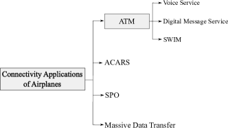
II-A2 Aircraft Communication Addressing and Reporting System (ACARS)
ACARS is a data protocol developed to provide connectivity between airplanes and airline operation control centers along with different ground entities such as flight explorer, oceanic clearance, and government agencies [55, 25]. Current operations support connectivity via both VHF and satellites in the Aeronautical Mobile-Satellite Service (AMSS) bands 1.1610-1.6265 GHz and 5-5.15 GHz [25, 56], and the message length is limited to 1960 bytes [55]. While EL comprises request messages such as weather updates and clearance requests, IL exchanges the requested information [55]. In addition, both links provide text messaging service [55].
ICAO foresees the extension of ACARS into VDL-2 and broadband satellite systems to meet the increasing aviation demand [50]. Furthermore, the IP v6 protocol can be part of the future ACARS; however, datalink security remains a major concern [57]. Therefore, the study, [58], proposed a detection and authentication-based safety architecture.
II-A3 Single-Pilot Operations (SPOs)
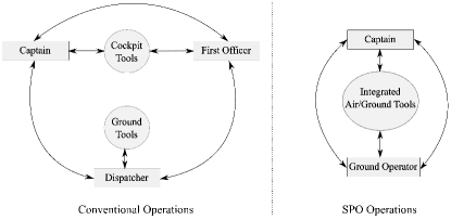
Future airplane operations may embrace SPOs, where only a single pilot is onboard and operates the airplane with the assistance of an onboard automation and/or a ground operator [7]. In such scenarios, the connectivity can become a complementary technology to support the safe operation of airplanes in the air. Reliable and robust airplane-ground connectivity is the key for monitoring and supporting the operation of an airplane from the ground. The National Aeronautics and Space Administration (NASA) studies the concept of future SPOs and visualizes the evolution of flight operations for SPOs, as shown in figure 6 [7]. Instead of conventional separated air and ground tasks, they integrate air and ground tools, and share the flight-related tasks between the onboard captain and a ground operator. In such scenarios, aviation industry may also employ virtual reality technologies to enable smooth interactions [59]. Furthermore, appropriately defining the roles of the pilot and the ground operator is vital to ensure a coherent coordination [60]. As a result, SPOs have diverse research aspects, and the readers may refer to [61] for a comprehensive overview on the system design of SPO.
II-A4 Massive Data Transfer
Airplanes utilize massive number of sensors to monitor and predict maintenance actions [62]. Sensors help decrease the cost of maintenance and maximize the lifetime of airplanes. As an example, Airbus launched an open data platform Skywise to provide improved fleet operation through predictive and preventive maintenance [63].
Massive data transfer can take place just before landing, after taking off or on ground, e.g., at the airport or during airplane maintenance. It includes the transmission of collected sensor data as well as the data from the onboard computers. For instance, an Airbus A320 generates 10 GB data per flight hour [64], and thus, we must provide high-rate EL connectivity to transfer the onboard data within a short time interval until the next flight.
II-A5 Connectivity Requirements
We present the summary of the connectivity requirements of each airplane use cases in table IV. The requirements of ATM applications are based on ICAO’s specifications [47]. As for SPO, we observe an increasing QoS demands toward full SPO. Although NASA requires up to 10-8 communication reliability, wireless technologies can face extreme challenges to meet such high requirements due to the nature of varying RF channel conditions. In practice, we can meet this demand by utilizing 8 links in parallel assuming them uncorrelated with one another and each having 99.9% communication reliability. Thus, such high requirements can pave the way for novel optimization methodologies to reduce the number of required links in parallel and to efficiently use the available channel resources.
As for the full SPO use case, providing 20 Mbps with 300 ms latency threshold [7] is also a challenging requirement at altitudes above 10 km under high mobility rates such as 1000 km/h. Finally, we found out 45 Mbps for massive data transfer based on the study of [65]. For instance, we can offload a 4 hour flight data 320 Gb [63]) of an airplane in less than two hours using a 45 Mbps link. 100 ms latency is our assumption since a massive amount of data transfer must be completed within a short time interval while the airplane is on the ground [65].
| Application | Data Rate (Mbps) | End-to-end Latency (ms) | Communication Reliability | References | |
| ATM | VoIP | 0.012 | 100 | High | [47] |
| OLDI/FMTP | 0.01 | 1000 | 99.95% | ||
| AMHS | 0.02 | 5000 | 99.9999% | ||
| SPO | Current SPO ∗ | 0.03 | 40000 | 99.999% | [7] |
| Cargo SPO † | 15 | 10000 | 99.999% | ||
| Full SPO ‡ | 20 | 300 | 99.999999% | ||
| Massive Data Transfer | 45 | 100 | Medium | [65] | |
-
•
∗Crew operations in military airplanes.
-
•
†In 10 years.
-
•
‡In 20 years.
II-B eVTOLs
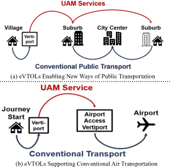
eVTOLs are the flying vehicles with vertical take-off and landing capabilities aimed mainly at passenger transportation, usually in short to medium range flight distances (80 km) [66]. We can consider eVTOLs as the spin-off of conventional helicopters equipped with electrical engines, therefore compromising in flight distances. Additionally, there is a pronounced tendency to operate eVTOLs without a pilot on board, which enables, e.g., new flying-taxi concepts. Thus, they complement the existing ground passenger transportation means in urban and suburban areas. figure 7 shows the new ways of transportation eVTOLs introduce [67].
The European Union Aviation Safety Agency (EASA) categorizes eVTOLs with respect to the number of passenger seating: a) 0-1; b) 2-6; c) 7-9 passengers and their maximum weight can be up to 3175 kg [68] with a maximum flight altitude of 1 km [69]. NASA foresees three main use cases for eVTOLs: 1) airport shuttle; 2) air taxi; 3) air ambulance [69]. Although eVTOL concepts are of the recent venture, several works already cover various research aspects such as the future requirements and the enabler technologies [70, 71], collision prevention, and collision mitigation techniques [72], safety risks arising from the interactions between the eVTOL pilot and onboard automation systems [73], and the optimization of the required time of arrival with respect to battery constraints and vertiport capacity [74, 75].
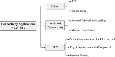
We present the connectivity use cases of eVTOLs in figure 8. We will first describe the Detect and Avoid (DAA) and vertiport connectivity, afterwards we will comprehensively elaborate on the UTM and its concept of operations.
II-B1 Detect and Avoid
The eVTOLs employ radar-based systems to detect obstacles and dangers during flights. DAA has two primary functions [76]:
-
1.
Detect conflicting AVs or other safety-threatening obstacles, events, and weather conditions.
-
2.
Determine and perform danger-preventive maneuvers.
Depending on the level of autonomy, the DAA system can notify the operator or it can take preventive actions by itself, which are computed by onboard systems. Thus, certain DAA systems have a control station on the ground [77]. In order to enable timely reactions against dangers, the DAA demands robust connectivity to send notifications to the remote pilot or to the conflicting AV. Broadcast communication can also be a part of the DAA, such that the eVTOLs periodically report their AV identification and location to their surroundings as well as to the UTM in real-time.
We can realize such a system with a conventional radar, i.e., an Airborne Collision Avoidance System (ACAS) [78], Automatic Dependent Surveillance Broadcasting (ADS-B) [79] and vision-based or sound-based detection systems e.g., Light Detection And Ranging (LIDAR) [80] or ultrasonic [81]. DAA establishes A2A links to communicate with the conflicting AVs, and the A2A reachability is an essential metric to ensure that the onboard system can detect an unknown object well in advance to avoid collisions. Therefore, its reachability requirement depends on the type of AVs, due to the varying speed and flight characteristics of AVs.
II-B2 Vertiport Connectivity
Besides rural and airport areas, we expect vertiports to be a part of the metropolitan infrastructures such as main bus/train stations and shopping centers [82] to provide convenient pick-up/drop-off locations to the eVTOL passengers. In such environments, eVTOLs require assistance from the ground to enable precise take-off and landing [83]. Hence, this demand takes place when the eVTOL is nearby a vertiport zone, requiring short-range and robust connectivity.
Similar to airplanes, eVTOL operators offload accumulated sensor as well as onboard computer data between the flights for predictive and preventive maintenance. This use case also demands short-range and high-rate connectivity.
II-B3 Unmanned Traffic Management (UTM)
As eVTOLs and UAVs occupy the sky, they must coordinate with one another, helicopters, airplanes as well as HAPs to efficiently share the low-altitude sky, which is within the class G airspace (uncontrolled airspace that begins from the surface and extends until the base of the controlled airspace [84]) [3]. Conventional ATM systems cannot meet the emerging eVTOL and UAV operations due to: 1) the increased number of total operations; 2) the increased vehicle density; 3) cruising operations at lower altitudes than that of today; 4) varying levels of pilot, automation and vehicle capabilities [85]. Thus, UTMs introduce the regulation of these vehicles in a more-autonomous manner compared with the ATM. MTC can become the dominant connectivity type in UTM rather than the human-centric ATM communication in the future [70].
Number of different UTM initiatives take place all over the world, such as U-Space in Europe [86], UTM in the USA [87] and JUTM in Japan [88]. Early research tackles various topics, e.g., airspace conflict resolution [89, 90] and flight planning [91].
We can summarize the list of main UTM services as follows:
-
•
Vehicle Registration: This service allows the operators to register their AVs in the UTM ecosystem to obtain flight permissions [92].
-
•
Vehicle Identification and Tracking: During a flight, an AV must broadcast its identification along with the current position information to its surrounding and to the UTM, which enables the real-time tracking of the AV [86].
-
•
Communication Services: UTM can also provide the connectivity means to AV operators to establish Control and Non-payload Communication (CNPC), which is also known as Command and Control (C2) Communication, with the AVs [92].
-
•
Flight Planning: UTM can design the trajectory of the flight considering airspace flight rules, restrictions, etc. and send it to the AV [92].
-
•
Airspace Authorization and Restrictions It provides permissions to use the airspace for the corresponding AV [92], and regulates geofencing and geocaging.
- •
-
•
Conflict, Separation and Emergency Management: By utilizing the real-time tracking information from the AV, UTM can ensure separation between the AVs and avoid conflicts in advance with dynamic rerouting updates. [92]. In case of emergencies, UTM can guide an AV to an emergency landing zone to avoid danger in the air. The eVTOLs can also have DAA capabilities to detect obstacles nearby and take timely actions to avoid conflicts [86].
-
•
Weather and Mapping Services: UTM can provide weather and terrain related information to the AV operator to increase the safety of the flight [92].
-
•
Cooperation with ATM: UTM must cooperate with ATM near the airport zones, where the AVs share the low-altitude airspace[86].
NASA developed a UTM architecture [93, Figure 3], and located Unmanned Aircraft System (UAS) Service Supplier, which is similar to the air navigation service supplier in manned aviation, at the center of the UTM ecosystem coordinating the interactions between different services. They included the 3 party data services, remote operators, public safety as well as a gateway to the national airspace system to support the operations of UTM [94]. Thus, the involvement of these entities and the interactions between one another influence the overall UTM connectivity architecture.
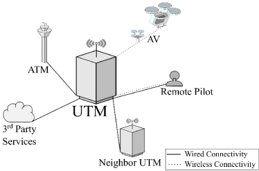
As eVTOLs and UAVs operate within short distances, national entities can establish UTM systems at regional levels [76]. In the event of inter-region or cross-border flights, different UTMs can cooperate with each other [95]. This implies the demand for handoff mechanisms between UTMs. Therefore, the functions of UTM strongly rely on the information exchange between different entities. Consequently, the connectivity is an essential function for the operations of UTMs. Based on all these interactions, we demonstrate the connectivity use cases of UTMs in figure 9.
UTM communicates with eVTOLs for the airspace regulation as well as the conflict resolution, and AV operators contact the UTM for flight requests, trajectory updates and other party services. The connectivity between UTM and eVTOLs must be robust to enable real-time and reliable information exchange. The connectivity between UTM and the ground pilot usually takes place before the take-off phase to acquire relevant flight permissions. Thus, available networks on ground can easily meet the connectivity requirements. Finally, wired connectivity enables the communication to ATM, neighbor UTM and other party services.
II-B4 Piloting
Before detailing the type of piloting scenarios, it is worth describing the well-known terms Unmanned Aircraft System (UAS) and Remotely Piloted Aircraft System (RPAS) in this context:
-
•
Unmanned Aircraft System (UAS): It is an airborne system without a pilot onboard [96], and an equipment to remotely control the aircraft [97]: It can be a ground control station, a remote pilot, a UTM as well as a communication system [98, 99, 100, 101]. We can divide the UAS into two subcategories: 1) RPAS; 2) fully-autonomous UAS, which can operate by itself without requiring any pilot intervention [96].
-
•
Remotely Piloted Aircraft System (RPAS): It is an airborne system that consists of a remotely piloted AV, its remote operator and a communication link [76]. Although RPAS is a subcategory within the UAS ecosystem [96, 97], ICAO distinguishes the UAS and RPAS in a way that RPAS has the same certification standards as manned aircraft. Yet, ICAO poses different certification requirements for UAS and separates it from the manned aircraft in the airspace [99].
| Application | Data Rate (Mbps) (IL/EL) | Latency (ms) | Communication Reliability | References | |
| UTM | Flight Supervision and Management | 0.01-0.1 | 500 | 99.999% | [10, 86, 102] |
| Piloting | Pilot onboard | 0.012 | 100 | High | [47] |
| RPO | 10-100/0.25-1∗ | 10-150 | High | [10] | |
| FAO | 0.1-1 | 100-500 | Medium | [10, 103] | |
| Vertiport | Assisted Take-off and Landing | 0.01-0.1 | 10‡, 140◆ | High | [10] |
| Massive Data Transfer | 25 | 100 | Medium | [65] | |
| DAA | 0.01-0.1 | 1000 | Medium-High | [77, 104] | |
-
•
∗For control/telemetry traffic.
-
•
†Video streaming for first-person view.
-
•
‡For IL link.
-
•
◆For EL link.
We grouped the piloting scenarios of eVTOLs into three categories based on the level of vehicle autonomy:
-
1.
Pilot onboard eVTOL: We can expect that the first integration of eVTOLs into airspace requires a pilot onboard to operate the vehicle. We assume that the pilot can communicate with ATM to obtain flight permissions, updates and other flight-related information in this first phase. Later, UTM can take over the management of the low-altitude airspace and directly communicate the AV. Lilium Jet [105] is an instance of a pilot onboard eVTOLs. Even though the onboard pilot handles the safety-critical functions, he/she nevertheless demands robust connectivity to coordinate the flight with the ATM as well as the party services.
-
2.
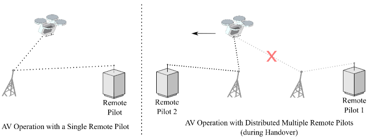
Remote Piloting Operation (RPO): In this concept, ground pilots remotely operate an AV, which can supply pilots with a first-person view by onboard cameras and other useful sensor data. Thus, these operations fall into the RPAS category and a technical report from ICAO defines a number of rules for RPO [76]:
-
•
Only one remote pilot can control an AV at a time,
-
•
Multiple remote pilots located at different regions can handle the operation of an AV during international or long flights, as illustrated in figure 10.
-
•
The transfer of CNPC between different network service providers is possible.
Therefore, RPO demands robust CNPC with seamless handover mechanism to enable control data exchange and multiple video streams between one or multiple end users. CityAirbus demonstration is an example type of this category [106].
-
•
-
3.
Fully Autonomous Operation (FAO): As the level of autonomy increases, the AVs can operate without a remote pilot. A ground supervisor can still be present to monitor the flight depending on the level of autonomy [107]. They can obtain the flight routes and updates from UTM and perform self-operations. Nevertheless, the remote supervision ensures safe operations to handle unexpected events in the air. Thus, Fully Autonomous Operation (FAO) falls into the fully-autonomous UAS category. Airbus Vahana demonstration [106] showed concepts of such operations.
CNPC is vital in RPOs and FAOs. On the EL, an AV transmits video stream along with telemetry-related information such as Global Position System (GPS), Inertial Measurement Unit (IMU) and other flight-related status information, and the remote pilot sends control commands on the IL [108]. Due to the critical role of the communication in the safe operation as well as the human involvement, the connectivity demands for RPOs are very stringent. The connectivity must support robust and real-time data exchange of asymmetric traffic on the EL and IL. While EL delivers the video streaming traffic, the IL hosts the periodic control data exchange to remotely operate the vehicle [109].
In general, we can expect an inverse correlation between the level of vehicle autonomy and the connectivity demand of vehicles during flight [110]. As AVs gain the capability of onboard computing, the controllers can process the video information onboard and perform piloting decisions in real-time. As a result, AVs utilize the ground communication only for status and flight-related information updates, and the communication reliability requirements are alleviated along with lower data rate and latency demands.
II-B5 Connectivity Requirements
| eVTOL Type/ Failure Condition Classification | Minor | Major | Hazardous | Catastrophic |
| 0-1 passenger | (DAL D) | (DAL C) | (DAL C) | (DAL C) |
| 2-6 passengers | (DAL D) | (DAL C) | (DAL C) | (DAL B) |
| 7-9 passengers | (DAL D) | (DAL C) | (DAL B) | (DAL A) |
-
•
The failure rates are the average probabilities per flight hour.
| DAL | Consequence of Failure |
| Level A | Crash, deaths |
| Level B | May cause crash, deaths |
| Level C | May cause stress, injuries |
| Level D | May cause inconvenience |
| Level E | No safety effect |
We analyze the communication requirements of eVTOL use cases and present the results in table V. As eVTOL concepts are of the recent venture, we mainly make realistic assumptions by relating its use cases to the similar ones from airplanes and UAVs subsection II-C.
Flight supervision and management requires a low-rate communication between UTM and AVs with a lenient latency bound, as defined by 3GPP [10]. For the pilot onboard scenario, we only assumed the voice connectivity to ATM to obtain flight permissions, updates and other flight-related information. Therefore, we assumed the same requirements as the VoIP use case of the airplanes in table IV.
The RPOs are the most connectivity-critical scenarios as the AV control merely relies on the communication from the ground. The data rate demands of eVTOLs are larger compared with that of UAVs. One of the reasons is that we can expect the double or triple redundancy architectures of conventional airplane flight systems to be employed for eVTOLs as well. Then, the number of sensors and avionic systems also increase in a similar magnitude. We also expect eVTOLs to be equipped with multiple or 360 cameras to provide a full-vision to the remote pilot. The latency demands are also tight as the remote pilot needs to operate the vehicle in real-time. Furthermore, the data path must be robust and secure to prevent unauthorized use of the link.
As the autonomy of the eVTOL increases, we assume that the onboard processors begin to take the major tasks of the remote pilot. Depending on the level of autonomy, connectivity can enable flight supervision/delegation or remote assistance in case of emergency [107].
Regarding the vertiport applications, we provided our assumptions based on the following reasoning. Assisted take-off and landing is a low-rate connectivity since it only contains bidirectional localization-related information exchanges. However, its communication reliability must be high with a tight latency threshold since it may be directly involved in the safe take-off and landing procedure of eVTOLs. For massive data transfer, we derived our assumption based on [65] for airplanes, and scaled it down since the data rate demands of eVTOLs can be lower due to the less number of onboard sensors and flight-related logs. As for DAA, it must also support robust communication when the remote pilot must perform maneuvers by herself/himself to avoid conflicts.
As for the communication reliability, we provide a perspective different from the available literature on eVTOLs, based on the Development Assurance Levels (DALs) in aviation. In conventional airplane systems, DALs define the criticality and the influence of each airplane function to the safe operation [112]. The DALs are mapped onto the system failure rates 10-3-10-9, based on the impact of that function to the operation of the vehicle [112]. EASA took a similar approach for eVTOLs and studied the required minimum failure rates of the safety functions of eVTOLs under different safety objectives, based on the number of passengers [68, 111]. We present the outcome of EASA’s study in table VI. For instance, if the failure condition of connectivity function causes a catastrophic event on a single passenger eVTOL, then the failure rate must be a minimum of 10-7 per flight hour.
In this table, some of the same failure rates are mapped onto different DALs. This can be due to the fact that EASA derived the failure rates based on the report [113] and the DALs according to the report [114]. Additionally, table VII shows the consequence of failure of functions based on their DAL levels in commercial airplanes [112].
We can consider the wireless communication link as one of the safety functions of eVTOLs, especially in RPOs. Thus, we can interpret the communication requirements based on table VI. At the same time, we also need to determine whether wireless links contribute to the communication reliability calculation in parallel with other functions or in series with a particular function. Considering the parallel scenario, the communication reliability must meet the rate of 10-7 per flight hour to avoid catastrophic events (e.g., fatal injury [113]) in eVTOLs with a single passenger. However, such high rates are difficult to achieve in wireless connectivity environment due to the unpredictable RF channel conditions (e.g. fading and shadowing) that can degrade the wireless link quality. Therefore, a comprehensive elaboration on the role of connectivity to the overall safety of the eVTOL is vital to determine the reliability demands accordingly. Nonetheless, we can still expect the communication reliability requirements to be up to 10-5 in RPOs due to the direct involvement of humans in the loop.
| Application | Flight Characteristics | Connectivity Requirements | References | |||||
| Altitude (m) | Speed (m/s)∗ | Deployment Density∗ | Area of Operations∗ | Data Rate (Mbps) | Latency (ms) | Communication Reliability∗ | ||
| Vision-based | 300 | 15 | Medium | Urban/Rural | 0.3-120 | 20-200 | Medium | [10, 115, 32] |
| Delivery | 100 | 15 | High | Urban/Rural | 0.2-0.3 | 500 | Low | [115] |
| Internet of Things (IoT) | 300 | 15 | Low | Urban/Rural | 0.05-0.25 | 10 | Low | [116, 117] |
| Agriculture | 300 | 15 | Low | Rural | 0.2-0.3 | 500 | Medium | [115] |
-
•
∗Our assumptions.
Regarding the FAO, we consider the connectivity requirements to be more relaxed compared with the RPOs, since flight decisions rely more on the onboard computation. We can expect up to 1 Mbps for periodic flight updates, vehicle status messages, and other operation-related information exchange [103]. The upper latency bound is 500 ms since the involvement of a ground supervisor is rare during flight and real-time operations should be handled onboard the AV. The communication reliability demands are also lower compared with the RPO as the connectivity is not a safety-critical function anymore. Regarding the broadband connectivity, we specify the capacity as 15 Mbps based on [118]. The total data rate per eVTOL depends on the number of onboard passengers.
Overall, various use cases require connectivity for eVTOLs and their requirements are diverse depending on the amount of information exchange and their role on the operation of the vehicle. The RPO is the most challenging scenario to provide robust connectivity. The communication reliability rate of 10-5 is beyond what the current wireless technologies can provide in aerial environments. Due to the nature of RF propagation, the RF channel conditions fluctuate depending on the environment and eventually, ensuring high communication reliability and seamless connectivity become difficult during an entire flight. Therefore, we foresee the demand for heterogeneous, multi-link network architectures for RPO. We discuss it further in subsection III-E.
II-C UAV
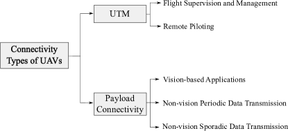
UAVs, also known as drones, are fixed- or rotary-wing unmanned AVs, which fall into the UAS category for non-human transportation. EASA categorizes these vehicles into three types: 1) 1 m maximum dimension and 5 kg Maximum Take-Off Mass (MTOM); 2) 3 m maximum dimension and 200 kg MTOM; 3) 8 m maximum dimension and 600 kg MTOM [119]. The maximum operation altitude of UAVs is dependent on the national regulations, usually 90 - 150 m [101]. We categorize the connectivity use cases of UAVs as shown in figure 11.
UTM handles the CNPC and coordinates the operations of UAVs, similar to the eVTOLs as described in subsubsection II-B5. The payload connectivity serves three main scenarios. Vision-based applications include all the use cases that involve data transmission with cameras. Afterwards, we divide non-vision applications into two categories: 1) periodic communication occur in a deterministic pattern such as IoT data collection; 2) sporadic communication are rather event-based, such as agriculture applications. We further discuss about the UAV applications in the following section.
II-C1 Application Scenarios of UAVs
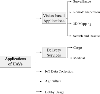
Although originally developed for the military use, civil applications acquired UAVs for different scenarios such as delivery, surveillance, agriculture, remote data collection and many more [120]. UAVs can operate in different environments, deployment densities, altitudes, and speeds depending on the requirements of the particular application. We categorize the application areas of UAVs as shown in figure 12.
| UAV Type/ Failure Condition Classification | Minor | Major | Hazardous | Catastrophic |
| Size: 1 m, MTOM: 5 kg | 10-2 (DAL D) | 10-4 (DAL C) | 10-6 (DAL C) | 10-8 (DAL B) |
| Size: 3 m, MTOM: 200 kg | 10-3 (DAL D) | 10-5 (DAL C) | 10-7 (DAL C) | 10-9 (DAL B) |
| Size: 8 m, MTOM: 600 kg | (DAL D) | (DAL C) | (DAL B) | (DAL A) |
-
•
The failure rates are the average probabilities per flight hour.
Vision-based Applications
UAVs can collect vision-based data such as the inspection of hardly accessible places or construction of critical infrastructures with high risk for workers [123, 124, 125, 126, 127]. UAVs can also serve 3D mapping [128, 129, 130] road traffic surveillance [131], cinematography [132], monitoring areas, or people [133], sports events [134] and also search and rescue in case of natural disasters or calamities [1].
UAVs for vision-based application usually fly below 300 m [10] with a low-speed or in a hovering condition to provide high-quality pictures, probably except for the events of news and sports [134]. Operating in both urban and rural areas, their connectivity requirements solely depend on the quality of video stream.
Delivery Services
Since the first successful cargo delivery in July 2015 [135], different industries such as grocery [136], postal services [137]. Research regarding the delivery services focus on the monitoring systems [138], delivery scheduling [139] and the optimized routing [140, 141, 142].
In delivery services, UAVs fly at low altitudes with a medium speed for an optimal delivery time. The authors of [143] presented a delivery service model using the rooftops of the buildings. Delivery services can demand connectivity for uploading destination waypoints and the remote tracking of the package [137].
IoT Data Collection
UAVs can collect also non-visual information such as sensor data about temperature, humidity, lighting or noise level [144]. A UAV can either sense the data directly with the onboard sensors or remotely collect it from distributed sensors [145].
In order to achieve energy-efficient UAV operations, a number of studies try to optimize the trajectory [146, 145, 147], minimize the data collection time [148, 148, 149], minimize the transmit power of IoT devices [150], device positioning [151], wireless charging solutions to remote IoT devices [152, 153], providing edge computing to IoT devices [154] or even underwater data collection [155].
For the collection of non-visual data, UAVs can operate at higher altitudes than UAVs for vision-based applications, while the maximum operational speed can be similar. Their communication requirements are more lenient than that of vision-based applications since they transfer lower amount of latency-tolerant data.
Agriculture
Agriculture use cases owned 80% of the global UAV revenues in 2017 [156]. To enable smart farming, UAVs can collect field-level data such as plant count, soil H2O level, temperature or imagery data for plant and animal monitoring [157, 158, 159, 160]. UAVs can also detect the growth of the plants [161], identify diseases in advance, reduce crop damage [162], support emergency situations that can harm the farms, such as wildfire [163], help with planting, crop spraying and irrigation [164, 165], fruit counting [166, 167] and planned harvesting [168]. All these use cases can advance agriculture in the years to come.
II-C2 Connectivity Requirements and Specifications of UAV Applications
We summarize the flight characteristics and the communication requirements of UAV applications in table VIII. While the flying altitudes may go up to 300 m, the flying speed is mainly 10-15 m/s. We can realize the majority of the use cases in both urban and rural areas.
II-C3 Connectivity Requirements for CNPC
We categorize the RPOs of UAVs into three types:
-
1.
Visual Line-of-sight (VLoS): A remote pilot operates the UAV within his/her range of vision with a direct link to the UAV.
-
2.
Beyond Visual Line-of-sight (BVLoS): A remote pilot operates the UAV beyond his/her range of vision, mostly via multi-hop connectivity.
-
3.
Fully Autonomous Operation (FAO): A UAV can autonomously operate from the take-off until it reaches the destination, and a remote pilot/supervisor may take over the control when necessary [107].
We present the connectivity requirements for CNPC of UAVs in table X. The data rate demands depend on the application type. VLoS operations may require data rates in the range of 5 - 150 kbps [8, 32, 109] for control and telemetry traffic, depending on the type of UAVs and the number of exchange parameters. We expect slightly less rates for FAOs [103] since the rate and amount of control data exchange is lower. As for BVLoS operations, the data rate demands on IL can be high due to the video stream for the first-person view [10].
The latency requirements of VLoS and BVLoS operations depend on the application scenario. While joystick-like piloting demand real-time communication, dynamic waypointing can relax this requirement. According to 3GPP reports, the latency requirements can vary 50-100 ms [10, 8], and Radio Technical Commission for Aeronautics (RTCA) specifies 155 ms as the upper bound [122]. However, the study of European Organisation for Civil Aviation Equipment (EUROCAE) assumes a rather relaxed latency threshold, which bounds to 300 ms [121]. In [109], where we experimentally modeled and measured the UAV data traffic, we find 250 ms to be the upper bound. As for FAO, the latency demand again depends on the type of operations. We must enable low-latency communication between an airborne controller and the remote pilot if ground components take role in flight decision processing. We can relax the latency threshold up to 5 s if the onboard controllers perform the flight-related decisions [10].
Remote piloting requires high communication reliability to ensure safe operations. Literature has not comprehensively evaluated the communication reliability requirements. While 3GPP states 99.9% reliability requirement for CNPC [8], RTCA requires 99.976% availability and 99.9% communication continuity [122].
Similar to our communication reliability analysis for eVTOLs, we evaluate the communication reliability requirements of UAVs based on its DAL specifications from EASA, which is shown in table IX [119]. From this table, we can expect the communication reliability requirements for VLoS and BVLoS operations to be 10-3 - 10-4, depending on the size and the MTOM of the UAV. In FAOs scenarios, we can relax this requirement to the range 10-2 - 10-3.
All in all, we categorized the connectivity use cases of AVs and identified their QoS demands emerging from these use cases. The QoS demands are diverse and stringent depending on the mission criticality of the particular application and thus, single technology may not be sufficient to meet the connectivity demands. In the next section, we will elaborate on the recent works regarding the capabilities of the wireless technologies to provide required QoS meets of the aerial applications.
III Communication Technologies
FACOM networks utilize various communication technologies to satisfy diverse connectivity requirements as outlined in the previous section. In this section, we extensively review the literature regarding the studies that evaluated the capabilities of wireless communication technologies in the context of FACOM. We categorize the wireless technologies as: 1) DA2GC; 2) SatCom; 3) HAPCom; 4) A2A. We group the studies according to the types of AVs they studied: We first show the works related to airplanes, then eVTOLs/helicopters and finally the UAVs in each subsection. We illustrate the categorization of this section in figure 13.
III-A Direct Air-to-ground Communication
DA2GC includes all the terrestrial technologies, which provide direct A2G connectivity to the AVs. We investigate DA2GC under three categories: 1) cellular networks; 2) IEEE 802.11 networks; 3) other networks. We present the state-of-the-art studies that tackle various research topics regarding the wireless connectivity demands of AVs in the following subsections.
III-A1 Cellular Networks
The recent evolution in cellular networks brings along the possibility of deploying them for AVs, as they inherited cutting-edge technologies to address the particular demands of different application scenarios. Especially, the emerging 5G technologies advertise prominent solutions toward facilitating the communication demands of diverse use cases. Network virtualization, network slicing and multi-access edge computing methods in 5G support flexible network architectures and traffic prioritization for mission-critical applications [169]. Furthermore, 3GPP discusses topics related to the connectivity in the sky, such as enhanced 4G support for aerial vehicles [8, 9], remote identification and tracking of aerial vehicles [10, 11], 5G enhancement for UAVs [15, 13] and the application layer support [12]. All these studies show the initial attempts to fit cellular technologies as a candidate solution for the connectivity demands in the sky.
We show the summary of the recent works in the scope of cellular networks for aerial communication in table XI. We categorized these works following the 5G terminology and the potential networking challenges. The majority of the studies focus only on the use cases of UAVs as the wireless connectivity applications of eVTOLs are of the recent venture.
| Cellular Domain | Subject | References | |
| Network Services | eMBB-baased A2G network design and performance evaluation | [170, 171, 172, 173] | |
| Feasibility of MBB for A2G connectivity of helicopters/eVTOLs | [174] | ||
| Evaluation of (e)MBB for CNPC via UAV field measurements | [175, 5, 171, 176, 177, 178] | ||
| A2G channel measurements and modeling for UAV CNPC | [179, 180, 181] | ||
| Evaluation of MBB for UAV-based video streaming | [182, 183] | ||
| Suitability of MBB for UTM-UAV connectivity | [184, 185] | ||
| uRLLC | Multi-operator connectivity to improve communication reliability | [186, 187] | |
| Coordinated Multipoint (CoMP) to improve aerial coverage | [188, 189] | ||
| Technology | Network Softwarization | SDN-based networking framework to support UAVs | [190, 191] |
| Performance evaluation of network slicing for UAVs | [185] | ||
| mmWave | Beamforming and beamtracking to improve UAV A2G channel quality | [192, 193] | |
| MEC | MEC for end-to-end latency optimization | [194, 195] | |
| MEC for the optimization of energy consumption of UAVs | [196, 195] | ||
| Issues and Challenges | Coverage | Coverage analysis for UAV A2G connectivity | [197, 198, 199, 188, 200, 201] |
| Trajectory Planning (TP) | UAV Trajectory Planning (TP) and optimization with coverage constraints | [202, 203, 204, 205, 206, 207] | |
| TP to maximize A2G channel quality | [208] | ||
| Joint TP and resource allocation for UAVs | [209, 210] | ||
| UAV TP with the consideration of antenna radiation pattern | [211, 212] | ||
| TP to optimize the energy consumption of UAVs | [196, 213] | ||
| Resource Allocation | Interference analysis and mitigation techniques for CNPC | [33, 214, 215, 216, 217, 218, 219, 220, 221, 222, 223, 224, 225, 226] | |
| Aerial UE-BS association and handover schemes to mitigate interference | [227, 228] | ||
| Evaluation of the coexistence of ground and aerial User Equipments (UEs) | [229, 230, 197, 189] [231, 232, 201, 225] | ||
| Antenna Design | Antenna design to maximize UAV A2G channel quality | [199, 200, 211, 233] [201, 234] | |
| 3D beamforming and beamtracking for UAV A2G communication | [235, 236, 237, 238] | ||
| Intelligent Reflecting Surface (IRS) to improve UAV A2G performance | [239, 240, 241] | ||
| Frequency Spectrum | Spectrum demand for UAV CNPC | [242] | |
| Spectrum reuse techniques to improve spectrum efficiency | [243, 244] | ||
eMBB
Enhanced Mobile Broadband (eMBB) is the main network services of cellular networks with human-centric high-rate communication characteristics. While articles [171, 173] experimentally study the 4G A2G network performance for airplanes, the authors of [171, 172, 245] theoretically evaluate the achievable DA2GC capacity. In [172], the authors compare the performance of 4G and 5G-based DA2GC as well as LEO satellite using a 20 MHz channel bandwidth. 5G DA2GC and LEO satellites significantly outperform 4G with the help of multi-user beamforming and spot beam technologies. Furthermore, we show that large planar antenna arrays (500-1000 antenna elements) can provide an average 1.2 Gbps EL to airplanes in the European airspace using 50-100 MHz bandwidth [245, 246].
The authors of [173] experimentally evaluate the 4G A2G performance on a research airplane and observed signal losses due to the directional antenna pattern. Although they measure a maximum of 40 Mbps on the EL, which is sufficient for ATM and SPO use cases, a signal loss at 3 km implies even worse performance for over 10 km cruising altitudes of airplanes. In addition, another study proposes a deep-learning based 5G A2G network design [170]. It consists of two deep neural networks, where the first one approximates the network behavior with respect to the user data rate, and the second one optimizes antenna up-tilt angles as well as the inter-site distances to achieve the optimal data rate.
Cellular DA2GC technologies gained maturity to be deployed commercially, and Gogo [247] as well as Smartsky [248] provide DA2GC in the North America. Gogo ATG-4 can achieve up to 9.8 Mbps per cell with more than 200 ground base stations. Deutsche Telekom, Nokia and Airbus tested a 4G-based ground station having a 100 km inter-site distance [249, 250]. According to their results, A2G link at 2.6 GHz with 20 MHz provides 26-30 Mbps on the EL and 17 Mbps on the IL with less than 60 ms latency for an airplane at 10 km altitude with 800 km/h speed. However, DA2GC requires increased spectrum resources to provide high achievable data rates.
As for helicopters, the authors of [174] propose a heterogeneous datalink architecture with 4G, VHF and SatCom to support ATM, airline operations, and control-related tasks. A number of studies performed experimental measurements with UAVs to evaluate the performance of eMBB in urban and suburban environments. While the authors of [5, 171, 176] analyze the data rate performance along with signal quality, the article, [175], also consider the handover conditions at different altitudes and evaluate how the handovers influence the data rate performance. Measurements report the maximum average data rate to be 40 Mbps on the IL and 20 Mbps on the EL [175]. Furthermore, [175, 177, 178] measure Reference Signal Received Power (RSRP) and Signal-to-interference Ratio (SIR) with UAVs flying at different altitudes and find out that multipath in urban areas causes severe signal fluctuations [178].
The authors of [251] measure the latency performance of 4G networks at 2.6 GHz with a UAV. While the average latency is 200-300 ms at 50-100 m altitude, the maximum latency is measured to be 2.5-3 s at 300 m. Such large latency values exceed the requirements for the remote piloting of UAVs (table X) and show the performance degradation of current cellular networks at high altitudes. Differently, the authors of [176] measure the average Round-trip Time (RTT) in the range 76-92 ms up to a 150 m altitude.
Regarding A2G channel measurements, the authors of [179, 181] derive a model with pathloss exponent and shadow fading in urban scenarios for the altitudes up to 40 m. The results show that the paths between the UAV and the BSs become more clear as the altitude of the UAV increases and the shadow fading is uncorrelated to the altitude. They further extend these studies by evaluating the feasibility of ray tracing models to predict the variations in the shadow fading [180]. By comparing the ray tracing model with the field measurements, they conclude a well match between the shadowing predictions of the model and the actual measurements.
eMBB technology can also support the connectivity demands of UTM. The authors of [184] evaluate the suitability of 4G for UTM-UAV communication and simulations show that 4G can support up to 200 UAVs/km2 using a 5 MHz channel with a message delivery ratio of 95% of 300 byte messages.
uRLLC
With the emergence of safety-critical robotic and machinery operations, the cellular ecosystem introduces Ultra-reliable Low-latency Communication (uRLLC) to provide robust connectivity solutions. uRLLC targets up to 10-5 communication reliability of 32 bytes with 1-10 ms latency [252, 253]. This technology is especially captivating for the BVLoS RPO in FACOM [254], and the authors of [255] discuss how the 5G ecosystem can provide reliable CNPC.
One of the methodologies to achieve uRLLC is to utilize multi-connectivity. Introducing link or network diversity can provide improved latency and reliability performance. In this regard, articles [186, 187], evaluate the performance improvement from network diversity using a single UAV connected to two different public 4G networks. We discuss these works in detail in subsection III-E.
CoMP improves the network performance, especially at cell edges, by jointly coordinating multiple BSs from the same network to serve a single UE. In the context of FACOM, we can consider CoMP to increase the cellular coverage in the air with the aid of multi-BS connectivity. In a recent study, [188], the authors achieve 32% coverage improvement with a UAV as an aerial UE using CoMP in their numerical analysis. Frequency allocation schemes between neighbor BSs, and the orchestration of data transmission can also influence the Inter-Cell Interference Coordination (ICIC), which the authors of [189] studied for UAVs having equal distances to its serving BSs.
Network Softwarization
Softwarization recently gained attention in the cellular ecosystem as it can provide flexibility and adaptability to the networks for particular QoS objectives. The AVs have numerous use cases with diverse QoS demands in FACOM, and thus, network softwarization can become a key element to support the aerial applications. In literature, several works study the softwarization methods with Software-defined Networking (SDN) architectures for monitoring and anomaly detection services of UAVs [190, 191]. Furthermore, the separation of control and user planes in the SDN can help cellular networks provide robust communication.
Network virtualization techniques can be beneficial to provide guaranteed QoS for the RPO in FACOM. We tested the resource isolation performance of network slicing with a single UAV on a 5G testbed [185]. Allocating dedicated resources for the CNPC link of the UAV, we show that the CNPC slice maintain the data rate and the RTT while we congest the payload slice in the same network. Furthermore, the authors of [256] combine network softwarization with blockchain technology in multi-UAV swarming scheme with the goal of increasing the network flexibility as well as data security.
Overall, these studies show that we can employ softwarization in a diverse set of applications, and we expect prospective studies also to exploit the benefits of softwarization on the use cases of airplanes and eVTOLs.
mmWave
This technology exploits the spectrum over 6 GHz for capacity-demanding applications with stationary end devices. In aerial communication, Milli-meter Wave (mmWave) can be suitable for the massive data transfer scenarios of airplanes and eVTOLs at air-/vertiports. Employing mmWave can be challenging in other scenarios, where AVs are in motion. Continuous beam alignment under 3D mobility requires sophisticated beamforming and beamtracking techniques. Nevertheless, a number of studies propose various beamforming techniques to provide stable A2G connectivity [257, 192, 193]. While the aim of [257] is to jointly optimize the beamwidth and beampower of the EL signal from UAVs, the authors of [193] develop a location-assisted beamforming technique to improve beam tracking and inter-beam interference cancellation. In addition, the article, [192], evaluates the beamtracking performance at 28 GHz for A2G channels and finds out that the channel quality is stable using aligned antennas within a particular error margin.
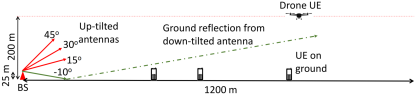
In [244], the authors consider a ground mmWave BS model with two antennas to simultaneously serve aerial and ground UEs with efficient spectrum sharing, as shown in figure 14. Via simulation studies, they find out that the 30 up and 10 down as optimal antenna tilting angles to simultaneously serve ground UEs and flying UAVs at 200 m altitude. From our perspective, we consider the usage of mmWave technologies challenging for eVTOLs and UAVs due to the difficulties of constant beam alignment, unless they follow deterministic flight routes (e.g. using corridors or following ground highways) like airplanes. Future works should also consider achievable data rates to offload high volume of flight data from eVTOLs at vertiports.
Mobile Edge Computing (MEC)
Mobile Edge Computing (MEC) hosts certain applications on the edge of networks to provide enhanced QoS and to reduce network congestion. In [196], the authors aim at minimizing the energy consumption of UAVs by partly offloading their tasks to a MEC-enabled ground BSs. Other studies rather utilize UAVs to support the ground networks, such as MEC-enabled UAVs to meet the latency demands of ground UEs [194, 195], or UAVs as cache servers [258].
Coverage
The ground-centric nature of cellular networks and their major deployments being in urban regions bring challenges to provide a seamless coverage in FACOM. Furthermore, the diverse altitudes of the flying platforms require a special consideration in the network design. In literature, a number of works study the coverage probability in the 3 dimension to enable CoMP transmission [188], to measure the network performance with different antenna configurations [199, 200], to evaluate the Signal-to-interference-and-noise Ratio (SINR) performance [259] and to study the influence from the distribution of charging stations [260].
We can define the coverage probability as the probability of receiving a SIR or SINR higher than a target threshold [199, 200]. Comparing omni-directional, doughnut-shaped sine, doughnut-shaped cosine and directional antenna radiation patterns, the authors of [200] conclude that the directional beam pattern with tilting angle toward ground BSs provides the best SINR coverage. They also find out that the optimal flight altitude to maximize the coverage depends on both the tilting angle of the antenna at the ground BS as well as the multipath effects caused by the flight environment.
The UAV altitude and pathloss exponent play significant roles in coverage probability [259]. When UAVs fly at 100 m altitude with an omnidirectional antenna, the authors of [201] report a coverage drop from 76% to 30% compared with the ground UEs according to their numerical analysis. However, using a directional antenna with the optimal tilting angle on UAVs can increase the ratio from 23% to 89%. In [198], the authors provide algorithms to generate large-scale blockage and pathloss maps to locate poor coverage areas in the air.
These studies show the severity of coverage problems in the air. Although they study the coverage scenario for UAVs, the operations of eVTOLs take place even at higher altitudes (up to 1 km [69]). In this case, we should also consider the trade-off between employing the existing ground infrastructure versus building dedicated A2G networks. Although dedicated network architectures can significantly eliminate the coverage issues in the air, it requires a novel network design to provide an interference-free coverage at varying altitudes along with a costly network deployment. Furthermore, the Electronic Communications Committee (ECC) mentions that the network operators do not intend to develop specific network planning for the use cases of FACOM [261]. Therefore, future studies should also elaborate on the trade-off between the operating public versus dedicated aerial networks for FACOM.
Trajectory Planning
Trajectory optimization problems are applicable especially for UAVs, as airplanes have predefined end-to-end flight paths. We expect also eVTOLs to follow predefined trajectories. Path planning is vital to avoid coverage holes [202] and to maximize the data rates by optimizing the resource allocation [213, 210] as well as to maximize the A2G channel quality for the routes of eVTOLs [208].
Several studies utilize the graph theory with different purposes such as the trajectory design using radio maps [203, 205], the tradeoff between the trajectory length and connectivity outage ratio [212] as well as the minimization of trajectory duration with a maximum tolerable outage duration [204]. Moreover, a number of works propose machine learning-based algorithms to capture the dynamic 3D environment for UAV Trajectory Planning. For instance, the authors propose deep Reinforcement Learning (RL) methods to plan the path of UAVs based on its connectivity constraints [206, 262], to minimize UAV mission completion time [207] and to minimize interference to ground UEs [263].
Resource Allocation
Interference is the most investigated metric for UAV communication due to the altitude dependency on the Line-of-sight (LoS) A2G channels. Resource allocation is a fundamental methodology to control the interference and helps UAVs and ground UEs coexist in cellular networks. According to a recent study from 3GPP [8], current terrestrial networks can support the aerial UEs up to 300 m altitude, if the percentile of the aerial UEs remain below 33% per cell.
While the authors of [214, 219] study the EL transmission of UAVs to estimate the probability of outage rate and to minimize the interference for increasing the sum-rate, another study, [201], analyzes the IL coverage and spectral efficiency with the coexistence of UAVs and ground UEs.
Interference mitigation techniques play a key role to provide robust connectivity in FACOM, and we can categorize these techniques as [221, 225]:
-
1.
Interference cancellation;
-
2.
Inter-cell interference coordination;
-
3.
Beam switching;
-
4.
Power control.
In [220], the authors propose an interference cancellation scheme that adjacent BSs cooperate with the co-channel BS by not serving any UE in the channel of UAV to cancel the interference. Similarly, they also propose a UAV-assisted inter cell interference coordination scheme, where the UAV senses the transmission of ground users to determine the allocation of resource blocks [222]. Hence, they can avoid co-channel interference with the ground UEs.
In [215], the authors propose a cooperative beamforming technique at ground BSs to mitigate the interference to co-channel transmissions from the BS to the UAVs. Moreover, the authors of [231] jointly optimize the handover decisions and interference to ground UEs by a Q-learning algorithm. Differently, the authors of [233] employ directional antennas to improve the handover occurrences.
Overall, we can observe the particular attention of literature to interference subject for cellular networks. This challenge is one of the main drawback of the cellular ecosystem to host the FACOM applications with the already-existing infrastructure. Furthermore, the interference conditions may become even more problematic at higher altitudes (up to 1 km), where the eVTOLs operate. Similar to coverage challenges, acquiring a dedicated network infrastructure for FACOM can help avoid the interference problems in the air. The readers may refer to [33, 216] for detailed surveys regarding the interference solutions.
Antenna Design
Connectivity in FACOM requires novel antenna design to enable reliable communication. The design of the antenna beam depends on the use case. For instance, while directional beam patterns can enable coverage at higher altitudes, we can consider rather omni-directional patterns for A2A links for collision avoidance. In literature, the authors of [199, 200, 211] evaluate the performance of different antenna configurations, and the results reveal that the directional pattern provides the best SINR performance to UAVs. Furthermore, the authors of [233] consider the directional pattern at both BS and UAV antennas and reported a handover reduction rate of 50-75%. All these studies bring us to a conclusion that directional patterns can help improve the A2G channel performance.
Beamforming and beam tracking are relevant subjects in the antenna design. They can help alleviate the inter-cell interference issues introduced by direct LoS links from multiple BSs. However, unpredictable mobility of UAVs pose challenges to track the beams. Therefore, the authors of [237, 238] utilize the mobility information of UAVs to form and track the beams. Furthermore, optimal antenna tilting is also an essential parameter in the antenna design [201, 234].
Beamforming techniques can be practical also for the applications of eVTOLs. Different than free route mobility patterns of UAVs, eVTOL may operate along flight corridors (e.g., along the ground highways) and their flight routes can be more deterministic. For instance, we can equip up-tilting antennas on the already-existing ground BS towers along the highways to provide connectivity in the air.
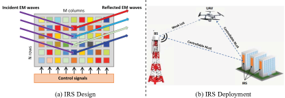
The IRS technology recently gained attention in RF systems. It is a reconfigurable surface in real-time in terms of electromagnetic absorption and reflections [240, 241]. While the authors of [240] evaluates the signal gain by deploying IRS on building walls, the article, [241] utilizes IRS on UAVs to increase the energy efficiency of the communication system. They achieve efficiency gain up to 50% by optimizing the beamforming vector at the BS and the phase shift matrix of the reflecting elements at the UAV.
Frequency Spectrum
The cellular spectrum are licensed and regulated for the ground UEs. Therefore, the aviation regulators must allow the usage of these bands for FACOM services. License Assisted Access (LAA) technology operates under unlicensed spectrum, and it can be favorable due to the global harmonization of the unlicensed bands. However, we can employ unlicensed spectrum only for certain non-safety applications due to the lack of regulation.
International Telecommunication Union (ITU) reported that 34 MHz is sufficient to enable the RPO over terrestrial networks [108]. As for airplanes and eVTOLs, we can also consider spectrum sharing with mobile and fixed networks since they can follow predefined flight routes. In this regard, ECC recently study the compatibility of aerial UEs within the licensed bands of mobile and fixed networks up to an altitude of 10 km using a single aerial UE [261]. While they conclude that regulations must limit the density of aerial UEs along with no-fly zones to avoid interference to ground UEs, they list several bands, in which aerial UEs can coexist in the existing mobile and fixed networks. We present the list of these bands with the restrictions of their usage in table XII.
| Frequency Range (MHz) | Coexisting Service | Restrictions |
| 703-733 | - Broadcasting Receivers - Radio Astronomy Servicess (RASs) | - Aerial UEs must fly 30 m above the ground. - No-fly zones or alternative measures around RAS sites for aerial operations in 700-713.5 MHz. |
| 832-862 | - Aeronautical Radio Navigation Services - RASs | - No-fly zones or alternative measures around RAS sites for aerial operations in 832-835 MHz. |
| 880-915 | - Railway Mobile Radios | - N/A. |
| 1710-1785 | - Meteorological Satellites | - Emission limit of -40 dBm/MHz in 1675-1710 MHz for aerial UEs operating in 1710-1785 MHz. |
| 1920-1980 | - Mobile-Satellite Service Complementary Ground Component (CGC) Aeronautical Systems - Future Railway Mobile Communication System Cab-radio Receiver | - Minimum separation distance of 15 km between CGC BSs and aerial UEs operating below 1980 MHz with out-of-band emission limit of -7 dBm/4.5 MHz. - Minimum separation distance of 2.5 km between CGC BSs and aerial UEs operating below 1980 MHz with out-of-band emission limit of -30 dBm/MHz (spurious). - Zero minimum separation between CGC BSs and aerial UEs operating below 1980 MHz with out-of-band emission limit of -30 dBm/MHz. |
| 2500-2570 | - Radio Astronomy - ATM Radars | - No-fly zones or alternative measures to protect the radars operating above 2700 MHz. |
| 2570-2620 | - RASs - ATM Radars | - No-fly zones or alternative measures to protect the radars operating above 2700 MHz. |
| 3400-3800 | - Fixed-Satellite Services (FSS) - Radiolocation Services - RASs | - Separation distance of 26.7-290 km between FSS earth stations and aerial UEs. - Unwanted emissions of an aerial UE limited to -60 dBm/MHz. - Unwanted emissions of an aerial UE limited to -50 dBm/MHz below 3400 MHz. |
To satisfy 99.9% communication reliability requirements of the CNPC of UAVs, the authors of [242] find out that a reservation of 1.4 MHz is sufficient for the current demand and can extend to 5 MHz spectrum in the next 20 years. Furthermore, the authors propose an aerial control system to increase the spectrum efficiency in the air in [243]. Their scheme separates the control plane and the data plane of UAVs and performs the control plane on A2A links to allocate the empty spectrum to A2G channels. Additionally, a recent study, [244], presents a network design with two antennas, dedicating one antenna per ground and aerial UEs, to enable spectrum reuse in cellular networks. We further discuss the spectrum challenges in subsection VI-D in detail.
| Wireless Technology | Subject | References |
| WiFi | Evaluation of data rate performance onboard airplane cabin | [264] |
| Coexistence analysis with 802.11.4e onboard airplane cabin | [265] | |
| Performance evaluation for UAV A2A communications | [266] | |
| Performance evaluation to support live video streaming for UAVs | [267] | |
| WiMAX | Suitability for rescue and mission operations of UAVs | [268] |
| ZigBee | Suitability for MTC communications onboard airplanes | [269, 270] |
| Connectivity for flight formation control of UAVs | [271] | |
| UWB | Suitability for MTC applications onboard airplanes | [272] |
| A2G channel measurements | [273, 274, 275, 276] | |
| Analysis of electromagnetic interference to UAV communications | [277] | |
| Antenna design to lower air drag on UAVs | [278] | |
| LoRa | Suitability for MTC communications onboard airplanes | [279] |
| Performance evaluation for V2X communications of UAVs | [280] | |
| Performance evaluation for RPOs of UAVs | [281] | |
| Suitability for UAV swarm communications | [282] | |
| Coexistence study with ATM radars | [283] | |
| AeroMACS | Performance evaluation for UAV applications | [284] |
III-A2 IEEE Networks
As IEEE technologies are vastly available on the market and exploit the unlicensed frequency spectrum, they can provide flexible and cost-efficient solutions in FACOM. However, the unlicensed spectrum raises several issues regarding the communication reliability and certifiability due to aviation safety requirements. Additionally, IEEE protocols are mainly suitable for the applications with short communication distance and therefore, their applicability for BVLoS operations can be challenging. We present the studies from literature with respect to the IEEE standards and we summarize the related works of IEEE as well as other A2G technologies in table XIII.
WiFi
WiFi is currently the most-widely used technology for VLoS UAV operations, thanks to the unlicensed spectrum and high data rates in LoS conditions. Conventional IFEC systems onboard airplanes utilize WiFi via Satellite backhaul [285]. Number of works evaluate this technology for the future use cases in FACOM.
In regards to airplanes, the authors of [264] compare the data rate performance of WiFi with 4G and Light-Fidelity (LiFi) onboard an aircraft cabin and found out that WiFi provides the worst data rate performance. Another work evaluates the coexistence of WiFi with a 802.11.4e Wireless Sensor Network (WSN) in an aircraft cabin [265] and proposes a whitelisted hopping method to increase the packet delivery ratio. As for UAVs, another study, [266], evaluates the performance of WiFi at 2.4 GHz for A2A links. Their experimental results indicate that the use of WiFi is not possible for A2A applications due to the large number of remote controls working in the same band. The authors of [267] aim to enable live multicast video streaming over multiple UAVs and thus, they develop Real Time Protocol (RTP)-based rate-adaptive point-to-multipoint streaming framework using the IEEE 802.11a protocol. Experimental measurements show up to 30% gain in the video quality compared with the legacy multicast.
Emerging technologies in WiFi can also alleviate the connectivity demands in FACOM. IEEE 802.11 ah standard paves the way for exploiting sub 1 GHz spectrum with coverage rate up to 1 km for IoT devices [286], which we can consider for low-rate non-safety MTC in FACOM. Recent IEEE 802.11 ax standard promotes over 6 Gbps data rates using a 160 MHz channel bandwidth. The 1024-Quadrature Amplitude Modulation (QAM) scheme helps WiFi achieve a high spectral efficiency in the unlicensed band. Additionally, the target wake time scheme enables a planned scheduling for power-constrained devices [18]. All these features in WiFi standards keep the rigorous competition between 3GPP and IEEE technologies for the use cases of FACOM. Furthermore, the upcoming IEEE 802.11 be standard even utilizes 4K-QAM schemes to maximize achievable data rates using 320 MHz bandwidth. It also enables multi-link operations along with multi-band aggregation to support low-latency applications [287]. Therefore, IEEE standards can embrace the emerging uRLLC use cases in the near term.
Overall, current WiFi solutions can be feasible mainly for the cabin applications of airplanes and eVTOLs. In the case of safety-critical cabin applications, IEEE protocols require certain modifications to achieve higher reliability rates. Although the utilization of unlicensed spectrum leads to cost-efficient solutions, the available spectrum is scarce and therefore, the supportable number of applications are limited.
WiMAX
Worldwide Interoperability for Microwave Access (WiMAX) is another option to provide a local network for AVs. It can provide large coverage rates up to 50 km with a maximum of 70 Mbps and 28 Mbps data rates on the IL and the EL, respectively [288, 289]. It can be practical especially for the use cases of UAVs, such as agriculture and disaster relief/public safety applications. In [268], the authors considered the utilization of WiMAX technology for connecting UAVs in rescue and monitoring missions in Alpine environments.
ZigBee
ZigBee is designed for the MTC applications and thus, a number of studies evaluated it for various MTC use cases of FACOM, such as the anomaly detection on the runways at airports in [269], hydraulic leakage detection on airplanes [270] and flight formation control of UAVs [271].
In general, ZigBee can be a cost-efficient solution for the MTC use cases in FACOM; however, their short coverage range (100 m [290]) along with the use of unlicensed spectrum limits their deployment scenarios in FACOM.
III-A3 Other Networks
Ultra-wide Band
Ultra-wideband (UWB) technology diversifies from the aforementioned narrow-band technologies thanks to its anti-multipath capabilities and the low-power consumption [291]. It can be suitable to support the communication demands of low-power applications onboard airplanes [272] as well as UAVs. The recent IEEE standard, 802.15.4z, propose enhanced positioning capabilities along with lower on-air transmission times [292].
Several studies perform measurements to characterize the A2G channels for UWB at between 3.1-4.8 GHz [273, 274] and at 6.5 GHz [275, 276]. Furthermore, another study analyzes the effects of UWB electromagnetic pulse on UAV communication links [277]. They state that the UAV link can be exposed to the strong electromagnetic pulse interference and therefore, it is necessary to install a protection module on the RF front-end. In this regard, UWB systems also require special antenna design to accommodate them in UAV environments. In [278], the authors present an antenna design with a 29 x 39 mm low-profile structure to lower the air drag during UAV flights.
LoRa
Long Range (LoRa) is low-power low-rate technology designed with the consideration of long-range MTC applications. An instance use case can be the vibration monitoring of aircraft structure, where the authors of [279] deploy a multi-hop LoRa network for this purpose. Another use case can be the Vehicle-to-everything (V2X) communication of UAVs. Utilizing LoRa, the authors of [280] manage to send data at 10 km range with 0 dBm transmission power, which is an energy-efficient transmission rate to cover such distance.
Although RPO use cases demand stringent communication reliability, authors of [281] propose the combination of LoRa and 3G modems to provide secure BVLoS RPO links. The authors of [282] also consider LoRa along with a low-latency Medium Access Control (MAC) layer for robust connectivity, but rather for the UAV swarms. Their tests with 10 UAVs and 20 robots lead to improved reliability than WiFi with the allowance of high swarm density as well as larger coverage.
LoRa operates in the 800 MHz frequency spectrum in Europe, in which the ATM radars also coexist and therefore, the authors of [283] evaluate this coexistence scenario. With an experimental evaluation, they suggest to increase the permissible interference level of dispatcher radars by 3 dB relative to the 20 dBV/m for 859 MHz and above in order to ensure the coexistence.
AeroMACS
AeroMACS provides safe and secure wireless communication in the C-band at the airports, and it can provide up to 18.2 Mbps and 6.8 Mbps on the IL and the EL, respectively [293]. WiMAX forum investigates the possible global employment of this system as a flexible and scalable solution for the connectivity demands of ATMs [294]. In addition, AeroMACS can work with the mobile satellite systems without creating significant interference [295]. In literature, the authors of [284] evaluated AeroMACS for the use cases of UAVs and analyzed its Orthogonal Frequency Division Multiplexing (OFDM) structure to evaluate its suitability. Their coherence time calculations showed that AeroMACS can support mobility rates up to 130 km/h.
LDACS
L-band Digital Aeronautical Communications System (LDACS) is an L-band terrestrial communication platform to provide a reliable connectivity service to future FACOM use cases in the aviation safety spectrum. LDACS has an OFDM-based architecture and can achieve up to 1.43 Mbps using 500 kHz channel bandwidth [296].
Internet Engineering Task Force (IETF) currently proposes an informational document about the LDACS system [296]. They define a 58.32 ms long frame and 250 ms super frame structures to provide robust connectivity. They aim to support the voice and data communication demands of the future civil aviation and they include not only A2G, but also A2A connectivity [296]. Recent flight tests with LDACS technology present the maturity of the technology for aviation [297]. Nevertheless, LDACS can also complement the satellite-based communication in the future [296]. Finally, ICAO also anticipates LDACS as one of the future wireless technologies for A2G communication [50].
| Wireless Technology | Subject | References |
| SatCom | Antenna development studies for radar and aircraft-to-satellite communications | [298] |
| Beam tracking and channel design for AV-to-satellite communications | [299, 300, 301, 302] | |
| Phased-array antenna development for AV-to-satellite communications | [303, 304] | |
| Achievable throughput analysis in A2G communications | [305] | |
| Impact of the antenna view angle on airplane-to-satellite communications | [306] | |
| Development of random linear coding for airplane-GEO satellite connectivity | [307] | |
| L-band channel model development for AV-to-satellite communications | [308] | |
| Development of novel methods to avoid satellite link blockage from helicopter blades | [309, 310, 311] | |
| Link adaptation techniques for AV-to-satellite communications | [312] | |
| HAPCom | HAPS to ground RF propagation modeling studies | [313, 314, 315] |
| Antenna and beamforming design to support airplane-HAPS communications | [316] | |
| Design of a novel MAC layer to enable joint FANET and HAPCom | [317] |
ADS-B
ADS-B is an RF-based surveillance system utilized in various aerial applications such as situational awareness, visual separation and inter-aircraft spacing [318]. AVs broadcast their position information (latitude, longitude), altitude, velocity, AV identification and other information to inform the other nearby AVs [318]. ADS-B is part of the NextGen program, which aims to modernize the U.S. air transportation system [319], and which recently began to mandate the installation of ADS-B systems on airplanes [319, 318]. ADS-B operates at 1090 MHz carrier frequency, reaching 1 Mbps data rate with a frame size of 56 or 112 bits [320, 321]. ADS-B can have transmission ranges up to 474 km [322]. ADS-B has two components: 1) ground terminal; 2) air terminal. Ground terminals are passive receivers and collect all ADS-B signals coming from different airplanes in the transmission range. By receiving its location from the onboard GPS system, airplanes broadcast their position, identity, altitude and velocity to the ground station [322]. Furthermore, air terminals communicate with bidirectional ADS-B signals. Airplanes periodically transmit the broadcast ADS-B signals, usually at a rate of 2 Hz [321].
ADS-B systems lately gain popularity and they can also provision collision avoidance systems for eVTOLs. As current ADS-B hardware challenges the Size, Weight and Power (SWaP) requirements of eVTOLs, uAvionix recently developed a modular ADS-B terminal to integrate this technology into eVTOLs [323]. Although UAVs can also host ADS-B systems [324], the ADS-B spectrum becomes saturated due to the excessive number of UAVs in the sky, limiting its scalability. Our approach to overcome this challenge is to utilize a ground based sense and avoid mechanism such that UAVs utilize cellular connectivity to report their position to a ground BS, which informs the other AVs and the ATM [79].
The US Federal Aviation Administration (FAA) regulates the mandatory use of ADS-B systems on airplanes since the beginning of 2020 [325]. Other variants of ADS-B systems are also under investigation, such as a multi-channel ADS-B receiver to enhance satellite-based airplane surveillance [326] as well as an ADS-B receiver payload design for nanosatellites to increase the current coverage of ADS-B systems [327]. Thus, ADS-B is one of the key enabler technologies for collision avoidance use case of future airplanes.
III-B Satellite Networks
In this section, we begin by providing a background on the SatCom. Followed by the state of the art in the satellite services, we then discuss some of the challenges utilizing SatCom to support the connectivity use cases of FACOM. We present the summary of the literature review of SatCom in table XIV.
III-B1 Background
We can classify the satellites operations with respect to their frequency spectrum, as shown in table XV [328]. While GPS carriers and mobile phone satellites operate on the L-Band, the S-Band is used for radars, weather systems as well as SatCom [298, 329]. The satellite TV network occupies the C-Band since it is less susceptible to rain-fade than Ku-Band due to longer signal wavelength. The spectrum is less congested at Ka-band, whereas, it is a major constraint for satellite operators at C- and Ku-band [330]. Ka-band satellites are highly efficient with a lower bandwidth cost [330]. As the available spectrum is limited in lower frequency bands, satellite operators began to investigate the Q/V band to provide high-rate broadband services [331]. For instance, Hughes network aims to launch its JUPITER 3 system, which can provide up to 500 Gbps using Ka-, Q- and V- band [332]. However, the main challenge of Q/V band is the high sensitivity to the atmospheric conditions, such as rain [332].
The size and the weight of user terminals are essential parameters in FACOM due to stringent SWaP requirements of AVs. Large antennas, as specified in table XV, can be challenging to deploy in eVTOLs as well as UAVs. Additionally, satellites terminals are usually power-starving due to the large communication distances. For instance, current Inmarsat satellite terminals for machine-to-machine communication can demand up to 50 W during data transmission [333]. This is another drawback to realize SatCom in FACOM due to the limited onboard power resources, especially on eVTOLs and UAVs. Finally, although we find more available spectrum at mmWaves, it further increases the power requirements to compensate for the link budget. The 3D mobility of the AVs requires advanced beamtracking and beamsteering techniques in mmWave scenarios.
We can classify the types of satellite handovers as follows [334]:
-
•
Link Layer Handovers: It occurs when the UE switches one or more links between the communication endpoints due to the dynamic connectivity patterns of LEO satellites.
-
1.
Spotbeam Handover: It takes place when the UE crosses the boundary between the neighboring spotbeams of a satellite, an intra-satellite or spotbeam handover occurs.
-
2.
Satellite Handover: It happens when the satellite transfers one of its existing connection of a UE.
-
3.
Inter-satellite Link (ISL) Handover: This type of handover happens when interplane ISLs are temporarily off due to the change in distance and viewing angle between satellites in neighboring orbits. It causes rerouting of the current connection, which results in a handover.
-
1.
-
•
Network Layer Handovers: It occurs when one of the UEs changes the IP address due to change in coverage or mobility.
-
1.
Hard Handover: It is the break-before-make scheme, where the previous link is released before establishing the connection to the new link.
-
2.
Soft Handover: This is the make-before-break scheme, where the previous link is released after connecting to the new link.
-
1.
-
•
TABLE XV: Satellite Frequency Bands and Their Characteristics for Civilian Use [328, 335, 336]. Frequency Band Frequency Range (GHz) Available Spectrum (MHz) Antenna Type and Diameter (m) L-band 1-2 15 Omnidirectional 0.2-0.6 S-band 2-4 70 Omnidirectional 0.2-0.6 C-band 4-8 500 Directional 1.8 Ku-band 12-18 500 Directional 0.9-1.2 Ka-band 26-40 3500 Directional 0.25-1.2 Q/V-band 40-75 5000 Directional 0.8-1.2
The effects of these handovers on the connectivity are important to evaluate potential service interruption scenarios in FACOM. As the communication reliability is an essential metric for CNPC, we should observe different ways to mitigate the effects of handovers, such as make-before-break method to avoid interruption before a handover takes place.
III-B2 Satellite Constellations
In this part, we provide the characteristics of the satellite constellations. We start with the capabilities of GEO and Medium Earth Orbit (MEO) constellations presenting their advantages and drawbacks for the use cases of FACOM. Afterwards, we discuss the recent advancement in LEO constellations along with the upcoming LEO services. We present the communication capabilities of these constellations in table XVI.
GEO
The GEO constellations are located 35786 km away from the Earth’s surface at the geosynchronous orbit to match Earth’s rotation. Its frequency reuse factors are low due to the large beam coverage and thus, it provides low-data rate per user within the beam [305]. However, GEO satellites compensate this by utilizing Ka-band to achieve lower beam width, and thus less beam coverage. ViaSat and Hughes are the instances of GEO broadband service providers [337]. With large latency characteristics, GEO broadband services can normally provide below 1 Mbps, with certain exceptional high-rate plans [338].
GEO links with usually in 700-800 ms [338] latency fail to serve mission-critical applications in FACOM that need low end-to-end latency. Additionally, the typically large and heavy GEO airborne terminals (up to 30 kg [328]) challenge SWaP requirements of AVs. Large-scale antennas are problematic for the low air drag requirements, and the connectivity cost is also high. A satellite terminal can cost 50-200 thousand $ for the aeronautical use [328]. This further limits its deployment in large-scale. Nevertheless, the global coverage is its main advantage, and we can consider GEO as a primary link in certain applications.
MEO
MEO constellations serve at the altitudes between LEO and GEO constellations. Although they are the least common constellation types, a number of upcoming satellite services occupy the space such as the new O3b, Audacy, Methera Global, Laser Light, ESA and CNSA constellations [339]. Current O3b networks utilize the Ka-band, and their beam coverage is around 700 km in diameter [340]. The end-to-end latency can be around 130 ms [341], which is a reasonable range for particular scenarios in FACOM. In FACOM, we can consider MEO to find an optimal balance between latency and coverage, although their large UE terminals can be still problematic to be integrated into eVTOLs and UAVs.
LEO
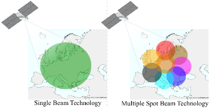
LEO satellites occupy the low-earth orbit with massive constellations to globally provide high-speed data services such as Starlink [17], OneWeb [16] and Telesat [342]. The number of LEO satellites can be as high as 12000 for Starlink constellations [17] and the constellation altitude for OneWeb is at 1200 km [16]. OneWeb promises to provide up to 400 Mbps per user [16]. Starlink and OneWeb majorly operate at the Ka/Ku-band utilizing a channel bandwidth of 250 MHz [342].
| Constellation | Altitude (km) | Coverage (km) | User/System Data Rate (Gbps) | Latency (ms) | Communication Reliability | References |
| GEO | 36000 | 4000 | 0.00085/300 | 700-800 | 99.5% | [343, 39, 344, 338, 345, 328] |
| MEO | 2000-20000 | 700 | 0.8/84 | 130 | 99.9% | [340, 341, 344, 328, 346] |
| LEO | 100-2000 | 450 | 0.75/7000 | 10-35 | 99.9% | [347, 348, 349, 350, 328, 351] |
Most of the broadband LEO constellations adopt multiple spot beam technology. This enables the High Throughput Satellite (HTS) concept based on a frequency reuse and high directive beam spot, as shown in figure 16. The number of spot beams per satellite is an essential factor in deciding the satellite delivered capacity. The number of spot beams per satellite can be as high as 50 (SkyBridge) with an average diameter of 2000 km [352]. HTS is ideal for point-to-point services [328]. One disadvantage of HTS is small beam elevation angles at high altitudes, which cause performance degradation [348]. OneWeb and SpaceX satellites may also be capable of steerable beams to enable user-centric services. Finally, OneWeb and SpaceX aim to enable user terminals with phased-array antennas with the minimum size of 30 cm [353, 352].
In FACOM, we can list several advantages of employing LEO constellations. The end-to-end latency rates are similar to that of conventional ground networks and thus, it can play a critical role to support the piloting applications of all AVs. Furthermore, small and light UE terminals with the possibility of flat array antennas can be suitable to the SWaP requirements of the AVs. Upcoming massive constellations promise high-rates with cost-efficient services and hence, they can be a part of the FACOM ecosystem to support high-rate and mission-critical services.
The main disadvantage of LEO is the rapid handover rate (as low as a few minutes [348]), which can frequently interrupt the connectivity and reduce the overall network availability. Thus, minimizing the service interruption time is one of the main challenges to tackle to integrate LEO in FACOM. For instance, phased-array antennas can mitigate this condition by enabling simultaneous connectivity to different spot beams before a handover takes place on the main beam.
The constant high-speed movement (i.e., 7 km/s) of the LEO satellites also pose challenges to provide reliable ISLs, which also introduce Doppler effects [348]. Additionally, the limited lifespan of LEO satellites, which can be 5-15 years [354], brings doubts on the service continuity on a long term.
III-B3 Challenges and Future Solutions
The constellation altitude and the number of satellites covering the Earth affect supportable node density in the covered area. We can achieve a higher satellite capacity while maintaining a wide coverage by increasing the number of spot beams as well as the frequency reuse factor. However, increasing the number of satellites and the spot beams result in a higher number of satellite handovers [355]. In this case, we can employ beam tracking technologies to reduce the handover rates, such as the blind method [299], step-tracking [300] as well as multi-mode-monopulse methods [300]. Similarly, the authors of [301] develop an antenna tracking system for UAVs on the Ka-band, and the authors of [302] investigate an algorithm for recursive 3D channel tracking for the UAV-LEO connectivity.
The emerging phased-array antenna solutions in LEO constellations can be promising for FACOM. In this regard, several works developed phased-array airborne antennas to enable SatCom at the Ka-band [303] and the Ku-band [304]. Additionally, Gogo claims that it can provide up to 100 Mbps with steerable phased array antennas, which are suitable for airplanes [356, 357]. Furthermore, antenna view angles from airplane to GEO satellites also impact the overall system performance, as investigated in [306].
The large end-to-end latency rates of GEO constellations make it impractical for the time-critical use cases of FACOM, and retransmissions further worsen the condition. Thus, the authors of [307] propose using random linear coding instead of retransmissions to avoid overhead latency on airplane communication. We can utilize LEO satellites for time-critical applications as its latency rates are in the same magnitude to that of DA2GC networks [348]. Furthermore, certain applications may demand high-rates such as the RPO as well as the vision-based applications of UAVs.
As for helicopter-to-SatCom, the blades of helicopters cause a periodic blockage, which worsens the RF channel. Several works introduce different methods to tackle this problem, such as Walsh-Hadamard code division multiplexing [309], time diversity with a novel channel estimation scheme [310], and also time diversity but with maximal ratio combining as well as zero-forcing [311]. These studies are beneficial for the communication between eVTOLs and satellites since their rotor blades can also influence the SatCom.
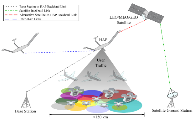
In regards to RF channel, the authors of [308] mention that available channel models do not realistically represent all the propagation impairments and thus, they derived a channel model on L-band with utilizing GPS signals. The attenuation due to tropospheric effects for air-to-satellite links is significant in mmWave frequencies [359]. Hence, the authors propose link adaptation algorithms and implemented them in MEO constellations for UAVs. They also further demonstrate the possibility of employing Software-defined Radios (SDRs) for adaptive SatCom systems [312].
Overall, SatCom has a key role to enable FACOM in the future. We should determine the suitable SatCom technologies per each aerial use case with respect to their QoS demands. Nonetheless, the aforementioned challenges require research efforts to fit SatCom into the FACOM ecosystem.
III-C HAP Networks
In this section, we investigate the utilization of HAPs for the use cases of FACOM. We discuss the background and state-of-the-art for HAPs and then we outline the challenges and open issues for their deployment in FACOM. We summarize the literature review of HAPCom in table XIV.
III-C1 Background
HAPs are quasi-stationary aerial platforms operating in the stratosphere, and located 17-25 km above the Earth’s surface [360, 361]. Their ease of deployment, incremental expanding, and high elevation angles, flexibility and reconfigurability, low-cost operation, as well as low propagation delay are their prominent features to provide robust connectivity to the sky. Furthermore, they have the capabilities of providing wide coverage, broadcast or multicast transmissions and the ability to move rapidly in emergency situations. Nevertheless, they pose certain disadvantages such as, the necessity of monitoring the station, the immature airship technology, and the stabilization of the onboard antenna [360].
The RTT propagation of HAPs is 0.13-0.33 ms [362], which is lower than the 4G subframe length of 0.5 ms. This enables the provisioning of cellular service while maintaining the original frame size. ITU regulates the transmit power limitations of HAPs to to avoid harmful interference [363] and hence, they do not pose threat to the human health. Similar to high throughput satellite systems, they can provide connectivity with spot beams antennas, and this enables many opportunities for scanning beams to follow the traffic. It also allows a smooth system growth, where the spot beam resizing can increase the network capacity, depending on the flexibility of equipment upgrade. Furthermore, HAPCom systems are relatively less complex than the LEO satellites systems, because of their proven stability against the motion [360] and they can even provide indoor coverage [360]. Total cost of a HAP system reaches about 50 - 300 million USD, depending on features of the system [364].
We can classify the HAPs based on the type of vehicle:
-
1.
Unmanned Airship (Air balloon): It has a semi-rigid propulsion system and can carry a mission payload of 1000-2000 kg [360]. They are mainly solar-powered balloons [365]. Their design allows them to stay about more than 5 years aloft up maintaining their position within a 1 km cube [360]. Google Loon is an instance of this type [366].
-
2.
Solar-powered Unmanned Aircraft: It adopts electric engines and propellers as the propulsion system [362]. Solar cells mounted on the wings and stabilizers power the aircraft [367]. The flying time is several months and the aircraft can usually carry 50-300 kg of payload. They are able to maintain their position within 1-3 km radius [360]. Airbus Zephyr is an example of solar-powered aircraft [368].
Besides the flight time, airships and solar-powered aircraft are also favorable as they can carry radio units to act as a relaying or base station equipment.
III-C2 Spectrum Allocation
ITU allocated a number of frequency spectrum in L-, S-, C-, K-, Ka- as well as V-band for HAPCom [362]. HAPCom may also receive the allocation of 18-32 GHz for fixed services since this spectrum is less sensitive to rain attenuation in comparison to the 47 GHz [360]. The bands around 47 GHz require twice the amount of power to guarantee the service availability to that of 28 GHz band [369, 370].
III-C3 Architecture and Design
In general, HAPCom systems can employ two different architectures: 1) relay station, which pushes the computation and complexity away from the airship; 2) base station, where HAPCom has an onboard processing system to process the relayed signal and also to apply beamforming techniques. Besides, HAPs can also serve for IoT services, as an aerial data center or as an alternative link to the UE to minimize the interruption of LEO handovers [362].
In literature, the authors of [372] mentioned that 16 HAPs can cover Japan and 18 HAPs are sufficient for the entire Greece. A HAPCom positioned at 20 km altitude can cover a radius of 50-200 km [372]. Moreover, HAPCom can host cellular architectures to enable non-terrestrial communication. We present an instance of a HAP architecture with cellular and satellite backhauling in figure 17 [358]. With this architecture, we can provide backhaul links either directly from the ground station or indirectly via A2A links. We can also utilize satellites as redundant backhaul links [373, 374]. Moreover, we can provide a flexible cell design to meet event-based temporal hotspot coverage with micro and macro cells [375]. As HAPs can provide large coverage in rural areas, multi-cell configuration with narrow beamwidth can help improve the link budget [376]. The authors of [377] propose ring-shaped cell clustering architecture and [378, 379] report that sectoring the inner and outer cells can help improve the network performance.
The displacement of a HAP poses two challenges:
-
1.
The displacement interrupts the backhaul link to ground station, which can affect the network performance.
- 2.
We can tackle the first challenge by acquiring multiple links to different ground stations so that HAP can connect to the one with the shortest LoS path. For the latter case, we must limit the maximum displacement distance so that the link budget remains sufficient or we can realize sophisticated user resource allocation techniques between different HAP units. Nonetheless, vertical and horizontal displacement on HAPs can cause coverage instability, interrupt the handover procedure and degrade the network performance [382].
HAPs should have the capability to control the beam to cancel the influence of altitude/position variation. Both multi-beam horn and digital beamforming antennas achieve the aforementioned requirements at different frequencies [383, 372]. As Multiple-input Multiple-output (MIMO) systems are deployable on HAPs, they can provide directional 3D beams with multi-antenna arrays to improve the link quality [362].
III-C4 The Role of HAPCom in FACOM
In the context of FACOM, we can employ HAPs for various purposes, such as urban area support for extended coverage or application-specific deployment to increase network capacity or communication reliability. HAPs can also collect sensing data from the sensors of other AVs or the sensors on its own platform. HAPs can also help in navigation and positioning services [384].
We summarize the general communication characteristics of HAPCom systems in table XVII.
In literature, the authors of [317] present a network architecture composed of HAPs and FANETs. They utilize HAPs to aid the neighbor discovery of FANET nodes due to narrow beams of directional antennas. Furthermore, in [385], the authors study a HAP-aided relaying satellite free space optics quantum key-distribution scheme to support secure communication of ground nodes and AVs. Finally, number of studies, [313, 314, 315], studied the RF propagation to correctly model the HAP-to-ground channels.
III-C5 Future Challenges
The movement of the AVs imposes a constraint on the maximum data rate that can be transferred. For fixed stations, the displacement of the HAP may cause a deviation of the main lobe. The required data rate determines the choice of steerable or fixed antennas. High elevation angles can be also another limiting factor due to the rapid changes in the angle. If fixed antennas are desirable to minimize the cost, a wider beamwidth antenna can serve to areas directly under the platform, while narrow beamwidth antennas can serve for long-distance coverage.
The authors of [386] provided a decent review of the research on the technology for a stratospheric communication system in Korea. From a networking perspective, IP routing can pose challenges over hybrid HAP-satellite systems. Topology information can rapidly become obsolete, especially when we employ a LEO backhauling to provide global connectivity. Multicasting can be an alternative option; however, developing efficient multicast protocols for time-variant HAP links can be challenging. Handover scenarios in HAPs demand a particular attention. Considering the varying cruising speeds of the AVs as well as the displacement of HAPs, handovers can take place very often, thus further studies should also cover the handover aspects.
Overall, while HAPs can alleviate the provision of high-rate and low-latency services for AVs, they also pose particular challenges to provide reliable links. Nevertheless, HAPs can provide cost-efficient and dynamic solutions for FACOM. For a comprehensive overview about HAPs, the readers may refer to the survey [362, 387].
III-D A2A
FANETs are a subclass of Mobile Ad-hoc Network (MANET), in which the mobile nodes are the AVs [388, 389]. MANETs are formed by inter-connecting the AVs and routers so that AVs can directly communicate with each other or relay the information without the involvement of a ground system, as shown in figure 18.
FANET nodes move with higher speed and have more degree of movements than that of MANETs but rather have more predictable mobility models with less node density [390, 391].
FANET poses particular advantages to become a vital part of FACOM and we can list a few of them as follows [392]:
-
•
FANET addresses the resource management issues that may arise from using satellite resources to support the rapid increase of IFEC.
-
•
It also addresses the problem of provisioning delay sensitive applications as an advantage over satellite links.
-
•
In comparison to satellite or ground stations systems, FANET systems require less time and cost for deployment. Hence, it gives mobile network operator a feasible solution for broadband data provisioning in comparison to IFEC via satellite.
While airplanes can realize A2A links to increase network capacity for IFEC, we foresee two potential use cases for the A2A links of eVTOLs:
-
1.
Collision avoidance;
-
2.
Data relaying.
The former one requires low data rates, and it also inherits broadcast-based signalling to detect and avoid safety-threatening conditions in the air. The data relaying can be useful to provide connectivity for the AVs outside the coverage area or to deliver time-critical data to the ground network in a timely manner. We can realize this use case in hybrid with another technology, such as DA2GC or SatCom. This way, A2A can support the primary link to increase the overall data rate or to extend the coverage in rural areas. However, the data relaying use case can be less likely for deployment with the consideration of the SWaP and cost requirements of the AVs.
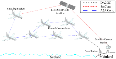
III-D1 A2A Standards
Standardization regulatory recently exposed FANETs to address the connectivity issues of ground and aerial vehicles. In this regard, 3GPP and IEEE proposed new protocols, which paved the way for commercializing the A2A systems.
3GPP V2V
Although cellular systems are naturally human-centric networks, 3GPP initiated novel releases to enable direct communication between vehicles [14], Recent articles in literature also consider the 3GPP Cellular Vehicle-to-vehicle Communication (C-V2V) standards for aerial applications. The authors of [393, 394] evaluate a scenario, where A2A and EL channel of ground UEs share the same spectrum. They compare the interference mitigation performance of underlay and overlay spectrum sharing mechanisms [393].
In [395], the authors present a concept of UAV-to-everything (U2X) communication that include A2A links. They considered A2A links for relaying the sensor data collected by UAVs on the ground. The authors of [189] propose a 3D CoMP model for A2A communication, where UAVs were employed both as aerial BSs and as aerial UEs.
IEEE 802.11p
Although a number of works study this technology for the inter-connectivity of ground vehicles, its extension to aerial use cases require a particular attention. The authors of [396] evaluated the performance of this technology with flying and non-flying UAVs, and they achieve up to a 2.9 km communication distance at a 20 m altitude. Such communication range can enable multiple A2A connectivity options in dense airspace scenarios. Moreover, authors of [397] analyze video traffic transmission over 802.11p links, and they conclude that it cannot support video transmissions due to the bursty nature of the video traffic.
Number of studies experimentally modeled the 802.11 A2A channel at 2.4 GHz [398, 399]. They find out that power attenuation is similar to the free space pathloss model, and the multipath effect degrades at higher altitudes. However, the authors of [400] observe the pathloss exponent to be slightly higher than that of the free space at 60 GHz.
Several works compare the performance of IEEE 802.11p and C-V2V for vehicular use cases. While the authors of [401] report that 802.11p outperforms cellular V2X using different message lengths and inter-packet intervals, the numerical analysis study from [402] concludes that NR-V2X has superior communication reliability, latency and data rate performance compared with that of 802.11p.
| Technology | Standard | User Data Rate (Mbps) (IL/EL) | Latency (ms) | Communication Reliability | Cell Coverage (km) | Spectrum | References |
| Cellular | eMBB | 100/50 | 20 | 99.9% | 5-32 | Licensed∗ | [252, 253, 403, 102] |
| uRLLC | 0.1-1000†/8‡ | 10 | 99.9999% | 1 | |||
| mMTC | 0.1/0.15◆ | 890-2340◆ | 99.99% | 100 | [404, 253, 405] | ||
| SatCom | GEO | 0.85/0.49⊛ | 700-800 | 99.5% | 4000 | Licensed | [338, 345, 344] |
| MEO | 800/800 | 130 | 99.9% | 700 | [340, 341, 346, 344] | ||
| LEO | 750/375 | 10-35 | 99.9% | 450 | [347, 348, 350] | ||
| IEEE | WiFi 6 | 1200 | 10 | N/A∙ | 0.3 | Unlicensed | [406, 18, 407] |
| WiFi 7 | 30000 | 5 | [19, 407] | ||||
| HaLoW | 0.15-3.9 | 100-3000 | 99% | 1 | [408, 20, 286] | ||
| WiMAX | 70/28 | 37-77 | - | 50 | [288, 409, 289] | ||
| ZigBee | 0.25 | 15 | - | 0.1 | [290] | ||
| LoRa | 0.003-0.027 | 56-1400 | 15 | Unlicensed | [410, 411] | ||
| AeroMACS | 18.2/6.8 | 60 | 99.9-99.95% | 8.3 | Aviation | [293] | |
| LDACS | 0.315-1.428/ 0.294-1.390 | 100 | - | 370 | [296, 412, 413] | ||
| A2A | C-V2V | 3-27 | 20-100 | 67-99% | 1 | Licensed | [14, 414, 415, 416] |
| 802.11p | 3-54 | 100 | 59-98% | 0.4-2.5 | Unlicensed | [14, 417, 415, 418] |
-
•
∗LAA technology operates in the unlicensed spectrum on IL.
-
•
†According to the study of Next Generation Mobile Networks (NGMN) [102], the data rate capabilities of uRLLC can be diverse, due to different application requirements.
-
•
‡Only given value in [102], which is for automated guided vehicle applications of uRLLC. Similar to IL, the data rate capabilities of EL can depend
on the application scenario. -
•
◆Although these values are for the Narrow-band Internet of Things (NB-IoT) of 4G, we assume similar capabilities in mMTC with the support of higher node density.
-
•
⊛The Global Xpress service of Inmarsat claims up to 50 Mbps on IL and 5 Mbps on EL, respectively [338].
-
•
∙WiFi 6/7 provides improved communication reliability thanks to the introduction of Multi-user Multiple-input Multiple-output (MU-MIMO) and longer OFDM
symbols [406].
III-D2 Challenges and Potential Solutions of A2A for FACOM
As the literature comprehensively covered the FANET protocols for UAVs, we briefly provide the main challenges and potential solutions, especially toward airplane and eVTOLs. The readers may refer to the FANET-focused surveys such as [419, 36, 35] to read more about the studies related to UAVs in FANET.
Coverage and Connectivity
Certain number of airplanes are in the sky at any given time that can form a FANET among each other. According to the air traffic data records of FlightAware [420], the number of airplanes in the sky at anytime were on average 9728, at maximum 12586 and at minimum 3354 in 2016. The range of communication between two airplanes should be within the minimum horizontal separation range, which is 9.3 km when a radar or an ADS-B system is in use [421]. In [422], the authors evaluate the capabilities of A2A communication to extend the DA2GC coverage. As an alternative to SatComs, A2A links can provide a 37 Mbps throughput up to 432 km DA2GC and 340 km A2A coverage.
Airplanes can establish LoS A2A connectivity up to 740 km distance due to the Earth’s curvature [423]. In order to provide connectivity at such a large distance, the authors of [423] design a geographic load share routing and access protocol, which utilizes the information about both the airplane’s position and the buffer size. It exploits the total A2G available capacity by balancing the traffic aggregated by all air nodes. Furthermore, we considered combining A2A and DA2GC links to maximize the number of airplanes that can be connected with a specific data rate threshold [424]. Our simulation studies show that over 90% of aircraft can have at least 50 Mbps in the region of North Atlantic. The authors of [425] also address the connectivity in between two airplanes based on their distance, transmission range, and airplane density in a one-flight route, whereas the study, [426], analyzes two-way flight route connectivity.
The authors of [427] evaluate the LDACS system for A2A communication between airplanes and compare the performance of ALOHA-based and the Spatial Time Division Multiple Access (STDMA) MAC mechanisms for the LDACS A2A system. They report that STDMA is a better candidate because LDACS requires the available bandwidth to split into 0.5 MHz sub-channels. In [428], the authors consider A2A links as secondary applications in the A2G frequency spectrum and let A2A applications transmit data on A2G spectrum whenever the channel is free.
Routing
Routing is a vital element of FANET for efficient and robust networking. Due to the different mobility characteristics of each type of AVs, they demand different routing mechanism to optimize the end-to-end connectivity. Several works proposed routing schemes for various purposes. Flat hierarchical structure of routing might be inefficient for FANET due to the large node density. Hence, the authors of [429, Page 122] propose a model for clustering of airplanes to produce a scalable system for a large global network of airplanes.
The high speed of the airplanes also influences the routing. Link stability and path interruption are essential parameters when designing the routing protocol. Moreover, designing a stable routing protocol via a clustering scheme must ensure that member airplanes of clusters do not frequently leave their associated clusters. The authors of [430] present an efficient method for constructing stable routes and clusters for ATM and operational-related communication. They also propose two routing schemes, based on random packet code division multiple access and trajectory based routing scheme, where the sender computes trajectory of each packet [431, 430]. This scheme enables simple path diversity without the need of geo-location exchange messages efficient broadcasting, etc. Furthermore, the authors of [432] design their solution based on finding the shortest path routing for FANET in an oceanic versus a continental study. In the oceanic one, they measured 68.2 kbps with a latency of 184 ms, whereas in the continental scenario, the data rate dropped to 38.3 kbps with a latency of 401 ms.
Air Interface
Airborne antennas must be omnidirectional or mechanically steerable to steer the beam pattern both in azimuth and in elevation. Beamsteering in azimuth and elevation is necessary in order to permit the relatively narrow antenna beam to be pointed at the satellite, so that the antenna can successfully receive a relatively weak signal [433]. Additionally, the antenna should be lightweight and have a low air drag due to the SWaP constraints of AVs.
Beamforming and beamtracking can be suitable for airplanes and eVTOLs since their mobility models are more predictable. The authors of [434] present an antenna array design that consists of 9 dipole antennas for FANETs. They aim to optimize the beamforming efficiency along with low side lobes. Besides the antenna design, dual-radio design can also improve the networking performance, as suggested in [435, 436]. The authors of [436] combine omnidirectional and multi-beam directional antennas, and use location predicting algorithms to enable beamtracking. They report a 35.8% increase in link robustness, which is measured by the ratio of the number of links that are not disrupted until the end of data transmission to the total number of established links between UAVs in the simulation.
III-E Multi-link Connectivity
| AV | Use Case | Cellular | SatCom | IEEE | L o R a | A e r o M A C S | L D A C S | A2A | |||||||||
| e M B B | u R L L C | m M T C | L E O | M E O | G E O | W I F I | W i M A X | H a L o W | Z i g B e e | C- V 2 V | 8 0 2. 1 1 p | ||||||
| A i r p l a n e | ATM | VoIP | ✓ | ✓ | ✓⋆ | ✓ | ✓ | ✓ | ✓ | ✓ | |||||||
| OLDI | ✓ | ✓ | ✓⋆ | ✓ | ✓ | ✓ | ✓ | ✓ | ✓ | ||||||||
| AMHS | ✓ | ✓ | ✓⋆ | ✓ | ✓ | ✓ | ✓ | ✓ | ✓ | ||||||||
| SPO | Current SPO | ✓ | ✓ | ✓⋆ | ✓ | ✓ | ✓ | ✓ | ✓ | ||||||||
| Cargo SPO | ✓ | ✓⋆ | ✓ | ||||||||||||||
| Full SPO | ✓ | ✓⋆ | ✓ | ||||||||||||||
| Mass. Dat. Trans. | ✓‡ | ✓‡ | |||||||||||||||
| e V T O L | UTM | Flight Mgnt. | ✓ | ✓ | ✓ | ✓ | ✓ | ✓ | ✓ | ||||||||
| Pilot ing | On- board | ✓ | ✓ | ✓ | ✓ | ✓ | ✓ | ||||||||||
| RPO | ✓ | ✓ | ✓ | ✓ | ✓ | ||||||||||||
| FAO | ✓ | ✓ | ✓ | ✓ | ✓ | ✓ | ✓ | ||||||||||
| Vertiport | Assis. T.O./Land. | ✓ | ✓ | ✓ | ✓ | ✓ | ✓ | ✓ | |||||||||
| Data Off loading | ✓‡ | ✓ | |||||||||||||||
| DAA | ✓ | ✓ | ✓ | ||||||||||||||
| U A V | Pilot ing | VLoS | ✓ | ✓ | ✓ | ✓ | ✓ | ✓ | ✓ | ||||||||
| BV LoS | ✓ | ✓ | ✓ | ✓ | ✓ | ||||||||||||
| FAO | ✓ | ✓ | ✓ | ✓ | ✓ | ✓ | ✓ | ✓ | ✓ | ✓ | |||||||
| Pay load | Vision -based | ✓ | ✓ | ✓ | |||||||||||||
| Delivery | ✓ | ✓ | ✓ | ||||||||||||||
| IoT | ✓ | ✓ | ✓ | ✓ | ✓ | ✓ | ✓ | ||||||||||
| Agri culture | ✓ | ✓ | ✓ | ✓ | ✓ | ||||||||||||
-
•
⋆When flying over the ocean.
-
•
†For safety-critical applications.
-
•
‡Potentially using mmWave technologies to achieve high-rates in an abundant spectrum.
Multi-link heterogeneous network architectures can be the enabler for achieving higher network capacity, reliable and robust networking as well as seamless coverage. In the context of FACOM, heterogeneous networking is essential in RPO applications. Although a single wireless link can provide sufficient data rate even for video streaming scenarios, it cannot achieve ultra reliable communication as well as ubiquitous coverage in different environments. For these reasons, we can introduce multi-link architectures with different means of diversity, listed as follows:
-
1.
Technology Diversity: As each communication technology has particular networking characteristics, we can employ them together to combine their advantages in a single network. An instance can be the combination of cellular and LEO networks. While cellular networks can provide robust connectivity in urban areas, LEO can support the operations in suburban areas with seamless coverage.
-
2.
Network Diversity: We can achieve this by utilizing multiple network infrastructures of the same or different wireless technologies. This architecture can ensure isolated end-to-end paths to improve the overall network availability.
-
3.
BS Diversity: Multiple BSs can simultaneously serve an AV to improve the overall communication reliability by introducing path diversity. If the BSs belong to the same network, then we can achieve diversity only until the first hop at the BSs. Thus, the overall capacity stays the same. CoMP architecture of cellular standard falls in this category.
-
4.
Frequency Diversity: A single BS can serve an AV with multiple links operating at different center frequency. Such operation can introduce different RF channel conditions in the same environment; thus, it can help increase the reliability until the first hop.
An early consideration of multilink architectures for UAVs is [437], in which they propose a novel link layer called FlowCode to enable the usage of conventional transport protocols in high mobility scenarios. FlowCode utilizes beam diversity from multiple transceivers to increase data and reception rate.
The authors of [187, 186] conduct field measurements with a UAV to evaluate the improvements in reliability and latency over multiple Mobile Network Operators (MNOs). The common notion of observing higher RSRP does not hold in urban environments according to the results in [187]. Furthermore, they report a performance gain with multiple links compared with single link due to the performance variations of the MNOs at different altitudes and environments. Furthermore, the authors of [186] show that while the minimum reliability rate with a single MNO is 97.6%, connectivity over dual operators can maintain 99.9% Packet Error Ratio (PER) at all altitudes on the IL. Although these studies show overall reliability improvement, guaranteeing reliability at any time instance can be challenging as the individual MNO designed their networks independently with the consideration of the ground use cases.
Besides utilizing dual MNOs, a combination of a public and dedicated cellular network can be another option, as the authors of [438] propose it with Multipath Transmission Control Protocol (MPTCP) for maritime search and rescue missions of UAVs. They conclude that the multi-link protocol increases the range and improves the data rate performance.
We can also consider multi-link connectivity using different wireless technologies. As each communication technology targets different use cases and owns different link characteristics, they can complement each other to ensure robust connectivity at all times during the mission of AVs. For instance, Deutsche Telekom and Inmarsat commercialized the European Aviation Network (EAN), which provides in-flight connectivity for airplanes using DA2GC as well as SatCom [439]. EAN can provide up to 75 Mbps on IL per cell with 300 base stations. In literature, the authors of [440] perform a modeling study with a satellite link and WiFi access points using MPTCP to control a convoy of UAVs. They aim to provide robust bandwidth allocation as well as high communication reliability.
In the cases where dual-connectivity is insufficient, we can increase the number of parallel links to increase the overall robustness. The authors of [441] present an example triple-redundant multi-link architecture employing cellular, WiFi and LoRa for the UAV-ground station connectivity. Their redundancy design employs a cellular network as the primary link and the other two as fallback links when there is no cellular coverage. Furthermore, the authors of [442] develop a novel application layer protocol called NECTOR, which is a User Datagram Protocol (UDP)-based architecture with two 4G and one satellite links. The receiver controls the packet reception rate with a torrent-based methodology and they improve reliability by employing network coding. In the end, increasing the number of parallel links can usually help achieve higher reliability. However, it naturally comes with extra networking cost. Thus, we should optimize the required number of links per the intended use case.
From these studies, we observe that the majority of the studies focus on increasing the overall communication reliability and the robustness of wireless links. However, we should also consider heterogeneity in the backhaul to increase the reliability for end-to-end packet delivery. We should also evaluate the different combinations of the communication technologies to determine how to achieve 10-5 communication reliability for RPOs of eVTOLs and SPOs of airplanes.
III-F Connectivity Options vs. FACOM use cases: Match Study
| Vehicle/Entity | Design Type | Study Goal | References |
| Airplane | A2G | Proposal of various A2G architectures to support IFBC | [443, 444, 445] |
| An IP-based A2G architecture for future ATM-cockpit communications | [446] | ||
| An SDN-based A2G architecture to enable multilink heterogeneous networking | [447] | ||
| Cabin | A gate-to-gate connectivity architecture for seamless passenger connectivity | [285] | |
| Performance evaluation of an integrated cellular network architecture | [448] | ||
| UAV | Cellular | Integration of UTM services into 5G system architecture | [449, 450] |
| A 4G-based network architecture to support CNPCs of UAVs | [451] | ||
| An LTE-based network architecture to enable aerial monitoring of remote locations | [183] | ||
| A2A | Comparison of the advantages and disadvantages of various FANET architectures | [452, 453, 454] | |
| Proposal of a new FANET architecture to avoid single point of failure | [455] | ||
| Proposal of a layered architecture with a low latency routing algorithm to minimize latency | [456] | ||
| Space-air-ground Architecture | Blockchain-based 6G space-air-ground architecture for secure UAV communications | [457] | |
| An SDN-based space-air-ground architecture for high-throughput and robust communications | [458] | ||
| Survey on different space-air-ground network architectures | [37] |
In this section, we numerically compare the capabilities of the wireless technologies against the connectivity requirements of FACOM use cases, as we presented it section II. For this reason, we provide the performance metrics of most of the evaluated wireless technologies in table XVIII. We consider the user data rate, latency, communication reliability, cell coverage as well as the spectrum as the most relevant metrics for the match study. Overall, each communication technology has unique performance characteristics and poses particular challenges to adapt themselves for the skies.
We present the conclusion of our match study in table XIX. Comparing the connectivity requirements of each aerial use case with the performance metrics of the communication technologies, we outline the candidate technologies that can support each aerial application. Furthermore, we highlight the most suitable technology for each use case in green. We do not include HAPs in wireless technologies as it does not have a specific connectivity standard. We also do not select WiFi technologies for the majority of the use cases due to their limited coverage and the single-hop nature. Similarly, we can consider C-V2V and IEEE 802.11p only for the DAA links of eVTOLs since their communication range is less than 1 km.
In regards to airplanes, LDACS is the candidate technology for the VoIP as well as the digital messaging services since it employs the aviation spectrum and has long frame durations to increase the robustness of the link. It also promises high communication reliability. However, LDACS cannot meet the high data rate requirements of future SPOs. Thus, we foresee that SPOs require a heterogeneous connectivity comprising eMBB/eMBB and LEO connectivity. While cellular networks can enable the connectivity during continental flights, LEO can complement it during intercontinental flights.
As for future eVTOL use cases, we expect that UTM communication can adapt LDACS to communicate with AVs. Due to human involvement in passenger transportation, connectivity is one of the critical functions. Utilizing aviation safety spectrum in LDACS can further enhance the overall communication integrity. Moreover, LDACS can ensure global spectrum harmony when UTMs in different regions need to coordinate with each other. However, LDACS is not sufficient for RPOs of eVTOLs due to the high rate video transmission. For this reason, we rather recommend cellular connectivity, if available, to ensure large network capacity. Although we do not expect transoceanic applications for eVTOLs, LEO can complement eMBB to improve the overall coverage.
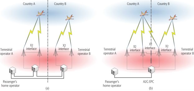
AeroMACS can be suitable for the connectivity demands at vertiports as its development particularly targets the connectivity applications at airports. While the Massive Machine Type Communication (mMTC) is sufficient for the MTC onboard eVTOL cabin, eMBB can support the data offloading at vertiport gates. As for DAA, we select C-V2V rather than IEEE 802.11p due to the advantages of licensed spectrum compared with the unlicensed spectrum, which we discuss in subsection VI-D. Although LDACS is another option for DAA, we prioritize it for RPOs due the limited bandwidth on the aviation spectrum. eMBB can also support the connectivity for piloting operations as well as the vision-based payload communication of UAVs. LEO can be the alternative solution when the operations take place in suburban regions.
Selecting the most suitable technology for each use case introduces a diverse set of wireless ecosystems in FACOM. These networks need to coexist together and operate without interrupting each other. Additionally, the deployment and operation cost of different networks further make it difficult to realize a large mixture of communication technologies in FACOM. Thus, it is also significant to utilize the technologies that can meet the demands of multiple applications so that we can minimize the heterogeneity of the wireless technologies.
IV System Architectures for FACOM
In this section, we present the recent studies that proposed various network and system architectures to enable the applications of FACOM in the sky. Dividing the studies with respect to their target AV platforms, we present the summary of the works in table XX.
IV-A Network Architectures for Airplanes
In [443], we compare decentralized and centralized DA2GC architectures on international routes, as shown in figure 19. We present advantages of the latter with a dedicated A2G network with a centralized core since this can enable better harmonization en-route and flexibility in providing QoS for different applications and resource allocation. However, the authors of [445] focused on the required modifications on the radio access part of the already-existing ground cellular infrastructures to provide A2G connectivity. They suggested placing directional antenna arrays facing upward on the BSs for airplanes, so that they could maximize the Signal-to-noise Ratio (SNR) with beamforming.
Providing connectivity over the ocean is the most problematic scenario for airplane connectivity in international routes. Although conventional networks utilize SatCom over the ocean, they cannot provide enough capacity to deliver high-bandwidth rates along with low end-to-end latency. To avoid this problem, the authors of [444] came up with a novel design of a ground network architecture with stationary ships located along the fiber lines in the north Atlantic ocean. We show the proposed architecture of [444] in figure 20. They suggested integrating ground BSs in these ships as well as in other remote islands. The fiber optic cables could serve as the backbone network to the BSs. This way, stationary ships could serve as communication as well as navigation service to airplanes, each BS covering a radius of approximately 370 km. This is such an interesting solution for transoceanic connectivity; however, the cost of operation of such a network with stationary ships in the ocean can be unfeasible from our perspective. Additionally, the waves in the ocean can continuously swing the ships causing the beam directions to alter.
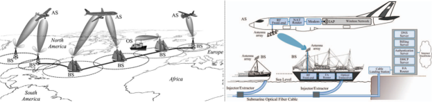
The authors of [447] present a novel architecture for passenger airplanes, which consists of airplane, access and ground network segments. They provide four different radio links for A2G connectivity using SDRs: 1) satellite; 2) LDACS; 3) AeroMACS; 4) VDL-2. They also integrate SDN on both the airplane and ground network segments to dictate the link selection, packet scheduling and other network configurations.
IV-B Network Architectures for UAVs
As RTCA specified only the physical layer for CNPC, the authors of [451] proposed a 4G-based network architecture for the upper layers. They inherited the conventional 4G functions into UAV environments to support mobility, security and access to the public. They also modified the PHY layer of 4G according to the RTCA ’s Time Division Duplexing (TDD)-based physical layer standards with the proposal of a new type of channel for CNPC-specific message exchange.
In regards to A2A, [455, 452, 454, 453] presented the conventional four types of A2A architectures for UAVs, as demonstrated in figure 21. While the decentralized multi-cluster architecture is practical for the missions that involve UAVs with different flight characteristics and mission tasks, single-cluster is preferable for UAVs of the same types. In figure 21 (d), one UAV serves as the backbone network for each cluster to provide connectivity with the ground station. While the centralized architecture minimizes the latency for CNPC, decentralized architectures are more robust for A2A links.
In order to avoid a single point of failure problem in the above-mentioned ad-hoc architectures, authors of [455] proposed having a secondary cluster head besides the primary head. Selecting the second cluster head based on the battery size, RSRPs and available battery life, the secondary head replaces the primary head once the primary head falls below a certain battery level threshold.
Integration of space-air-ground network segments also gained attention in literature, and the authors of [458] demonstrate an SDN-based space-air-ground architecture. Each layer has its own SDN controller, which are part of a total controller, as shown in figure 22. Upper layer controller manages the network resources and adjusts the network behavior. They store the backup of the upper controller in satellites to improve the security. Furthermore, the authors of [457] present a block-chain based 6G space-air-ground network architecture. The architecture is very similar to figure 22, except that they connect all the layers to a common block-chain network instead of SDN controllers. They inherit the block-chain technology to regulate the network behavior and manage the network security. They also charge the battery of UAVs with the signals from the 6G BSs.

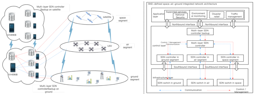
IV-C 5G System Architectures for UTMs
The authors of [449, 450] studied the required modifications on the cellular network architectures to integrate UTM services into it. Based on the 5G system architecture of 3GPP [459, Fig. 4.2.3-1], they implemented a special gateway, North-Bound Interface, with a UTM Gate Function for UTM [449]. The gateway serves as the mediator and coordinator of all the UTM functions. For cross-border flights, they proposed using dual sim cards on UAVs, since the current de-registration and re-registration processes take longer than 500 ms between UAS and UTM, as required by 3GPP [10].
Similarly, the authors of [450] also modified the 5G architecture to include aerial navigation, airborne user/control plane network functions, connectivity management and control. They introduced a novel control plane network function, UAV-based Network Service Control, to handle connectivity, resource management and location services related to UAVs.
Overall, these studies focus on the network architectures for airplanes and UAVs. Future studies should also elaborate on the dedicated ground network architectures for the UTM-eVTOL ecosystem, with the consideration of LDACS technology. As eVTOLs operate at higher altitudes compared with UAVs, they require particular attention. The sidelobe radiation from already-existing ground infrastructures may not be sufficient to provide reliable connectivity at high altitudes, up to 1 km. Moreover, space-air-ground architectures are essential to integrate heterogeneous connectivity to the AVs and thus, architectures targeting the combination of cellular and LEO networks gain importance.
V Open Source Simulation and Emulation Platforms
In this section, we provide an up-to-date list of open-source simulator and emulator platforms that can be practical in academic research. We divide the simulators into three main categories: 1) UAV simulators; 2) airplane simulators; 3) ATM simulators. In table XXI and table XXII, we categorize the available sources and compare them with respect to the platform type (simulator or emulator), flight and networking capabilities as well as their particular features, respectively. Some of the platforms have both flight and networking simulation capabilities. These can facilitate the researchers’ network-related experiments with minimal implementation efforts.
Each simulator and emulator platform has particular features that make them stand out toward different use cases. While AVENS [460] can be suitable for FANET simulations, UAVSim is rather useful for the simulations with satellite networks due to its integrated OMNeT++ OS3 satellite extension [461]. It also provides means to perform cyber security analysis in the simulation. Furthermore, FlyNetSim [462] offers multiple networking interfaces to perform multilink networking emulation in the same UAV platform.
Beside the ones with networking capabilities, AirSim is a powerful UAV simulator and emulator platform with vehicle, sensor and environment models [463]. However, it is not scalable for multi-vehicle simulations. In this regard, FlightGoogles can be an alternative option to enable multi-UAV simulations yet, it is especially designed for visual applications [464]. Lastly, number of platforms provide both simulation and emulation capabilities such as VENUE [465], FlyNetSim [462] and UB-ANC Emulator [466]. They can facilitate the deployment of custom algorithms from software to actual hardware environment.
Besides the AV simulators, we also have a short list of open-source UTM and ATM simulators, which can also be practical toward future studies of air traffic management: 1) InterUSS [467]; 2) BlueSky [468]; 3) ELSA [469]; 4) EuroScope [470]; 5) OpenScope [471]. InterUSS provides an interoperability platform between different UAS service suppliers, which is part of the UTM architecture [93, Figure 3]. Other simulators are mainly developed to foster the development of future ATM solutions, as we described in Section II-A1.
| Name | Simulator (S)/ Emulator (E) | Flight (F)/ Network (N) | Other Features | |
| AirSim [463, 472] | S&E | F | - Collision avoidance capability. - Camera, environment, sensor, vehicle models. - Deployable on a cloud. | - Realistic environment. - Weather and wind effects. |
| AVENS [460] | S | F&N∗ | - Flight dynamics and mobility. - Multi-vehicle support. | - Weather and wind effects. |
| AVIATOR [109] | S | Data Traffic Generator | - Traffic models based on actual UAV data traffic. | |
| CDSSim [473] | S | F&N† | - Designed for path planning algorithms. - Environment and mobility models. - Multi-vehicle support. | - Path planning capability. - Synchronization between the flight and network simulators. |
| CUSCUS [474, 475] | S | F&N† | - Flight, mobility and sensor models. - Multi-vehicle support. | - Path planning capability. |
| DroneVR [476] | S | F | - Environment and sensor models. - Object detection, tracking and avoidance capabilities. | - Path planning and optimization capabilities. - Web-based simulator. |
| FL-Air [477, 478] | S | F | - Multi-vehicle support. - Path planning capability. | - Sensor models. |
| FlightGoogles [464] | S | F | - Camera, sensor, motor dynamics and vehicle models. - Collision detection capability. - Deployable on a cloud. | - Multi-vehicle support. - Path planning capability. - Realistic environment. |
| FlyNetSim [462] | S&E | F&N† | - IoT connectivity environment. - Multi-networking support (e.g. UAVs can have both 4G and WiFi interfaces.). | - Multi-vehicle support. - Synchronization between the flight and network simulators. |
| Hector_quadrator [479] | S | F | - Camera, flight, motor dynamics, sensor and vehicle models. | |
| IoD-Sim [480] | S | F&N† | - Mobility models. - Multi-vehicle support. | - Path planning capability. |
| jMAVSim [481, 482, 483] | S&E | F | - Camera, sensor and vehicle models. | - Multi-vehicle support. |
| LimoSim [484, 485] | S | F&N | - Collision avoidance, mobility prediction, path planning and situational awareness capabilities. | - Environment, UAV energy consumption and mobility models. - Multi-vehicle support. - Synchronization between the flight and network simulators. |
| MAVBench [486] | S&E | F | - Battery, camera, energy, environment and sensor models. | - Designed for performance and power optimization-related studies. - Object detection and tracking capability. |
| multiUAV Simulation [487] | S | F&N‡ | - Charging stations. - Multi-vehicle support. | - UAV energy consumption model. |
| NUAV [488, 489] | S | F | - Environment, flight control and vehicle models. - Multi-vehicle support. | - Realistic environment. - Weather effects. |
| Obstacle Avoidance Simulator for UAVs [490, 491] | S | F | - Obstacle avoidance, object tracking and path planning capabilities. | |
| OpenAMASE [492] | S | F | - Camera, flight dynamics, sensor, UAV autopilot and vehicle models. - Multi-vehicle support. | - Object detection and path planning capabilities. - Wind effects. |
| OpenUAV [493, 494] | S | F | - Available from a cloud service. - Camera model. | - Multi-vehicle support. - Path planning capability. |
| PLANE [495] | S | F | - Environment and vehicle models. - Multi-vehicle support. | - Path optimization capability. - Weather effects. |
| ROS Quadrotor Simulator [496] | S | F | - Camera, engine, sensor and vehicle models. | - Path planning capability. |
| RotorS [497] | S | F | - Camera, environment, flight dynamics, sensor and vehicle models. | - Collision avoidance and path planning capabilities. - Wind effects. |
| Simbeeotic [498] | S&E | F | - Multi-vehicle support. | |
| SwarmLab [499] | S | F | - Collision avoidance and object detection and path planning capabilities. | - Environment and vehicle models. - Multi-vehicle support. |
| UB-ANC- Emulator [466] | S&E | F&N† | Energy comsumption, flight dynamics, mobility, sensor and vehicle models. - Multi-vehicle support. | - Path planning capability. - Synchronization between the flight emulator and network simulator. |
| UE4 [500] | S | F | - Camera and flight dynamics models. - Multi-vehicle support. | - Object tracking capability. - Realistic environment. |
| uavEE [501] | E | F&N◆ | - Multi-vehicle support. | - Propulsion power model. |
| UAVSim [461] | S | F&N⊛ | - Designed for cyber security analysis. - Multi-vehicle support. | - Mobility and vehicle models. |
| VENUE [465] | S&E | F&N† | - Mobility model. - FANET routing algorithms available. | - Multi-vehicle support. |
-
•
∗Integrated with the OMNeT++ FANET simulator.
-
•
†Integrated with NS-3 simulator.
-
•
‡Integrated with OMNeT++ simulator.
-
•
◆Users can select the wireless radio interface.
-
•
⊛Integrated with the OMNeT++ OS3 Satellite Extension.
| Name | Notes |
| CRRCSim [502] | - Realistic flight model. - Support for aircraft control using remote control. |
| FlightGear [503] | - Aircraft modeling. - Flight dynamic models. - Multi-vehicle support. - Sky model. - Vehicle types: A320, 747, 1903 Wright Flyer. - World scenery database. |
| Geo-FS [504] | - Flight dynamics. - Multi-vehicle support. - Real-life ADS-B in real-time. - Real-time atmospheric conditions. - Realistic physics engine. - Vehicle types: Aircraft, glider, helicopter, air balloon. |
All in all, open-source community has plenty of simulator and emulator platforms to support the future studies of FACOM and the researchers can utilize these resources to facilitate their works and to further extend the capabilities of these platforms. As we leave the detailed overview of these platforms outside the scope of our study, we let the readers investigate further themselves to determine the most suitable ones for their research. Nevertheless, these tables provide the most relevant features and the capabilities of the simulator and emulator platforms. The simulators may have more capabilities than what we listed in the tables.
VI Open Research Challenges in FACOM
In this section, we highlight the future challenges and open problems to provide connectivity to the use cases of FACOM.
VI-A Artificial Intelligence
Artificial Inteligence (AI) recently gained attraction in wireless communications. Number of works applied AI in various topics such as finding optimal deployment location for aerial BSs [505, 506], prediction of the location of an aerial BS [507] and aerial channel model predictionaaa [508, 509].
RL is based on trial and error method to learn from past decisions. It is also utilized in various studies to optimize routing [510, 511] as well as ground coverage [512, 513]. Nevertheless, we can utilize AI-based techniques in FACOM in future studies. Also, the available computational power on AVs makes it possible to deploy AI in the air. We can consider AI as the facilitator to realize heterogeneous multilink networking. Novel techniques can enable intelligent routing to efficiently utilize the available channel resources to meet the QoS demands of different aerial application. In a multilink networking environment, AI can help predict vertical and horizontal handovers that occur in different links and optimize the link selection. Such methods can support meeting the stringent reliability and latency demands of the CNPC traffic.
VI-B Diversity and Unified Network Design
One of the main challenges in FACOM is the diversity of the AVs, their use cases and the wireless communication links. AVs differ in vehicle and flight characteristics, cruising altitude, and the communication and SWaP requirements. Thus, the design of FACOM network architectures requires particular considerations to provide connectivity at different altitudes, mobility speeds along with the variant QoS metrics.
In table XVIII, we showed the diversity of the network performances of the candidate wireless technologies per each FACOM use case. We further emphasized the need of the heterogeneous connectivity for the RPO of the AVs. Although combining multiple technologies can increase the overall network robustness, its realization in real life is complex and costly. We must consider novel MAC and IP layer architectures to enable the coexistence of different wireless technologies. Furthermore, we need to consider the adaptation of the already-existing multi-link transport protocols or the development of novel protocols designed with the consideration of FACOM applications. Additionally, heterogeneous connectivity implies multiple radio interfaces on the AVs, which can challenge the SWaP requirements.
Heterogeneous networking in FACOM can demand smart coordination of the mixture of horizontal handovers on a same network and vertical handovers between different networks. Ensuring seamless connectivity in these scenarios can be challenging due to the limited information about handovers at UEs. Nevertheless, having the capability to predict an upcoming handover can enable the development of intelligent routing and congestion control algorithms to minimize the disruptions on connectivity. Additionally, the 3GPP introduce conditional handovers to 5G standards in Release 16, which allow UEs to make handover decisions at particular scenarios to improve the network robustness [514]. New research items can emerge from this feature to utilize the knowledge about handovers at UEs.
We should also scrutinize the emerging virtualization technologies to facilitate the integration of heterogeneous technologies in FACOM. SDN can help control the network resources in a unified manner and dynamically respond to the varying network conditions. Additionally, network slicing can help isolate priority traffic and can be one of the enablers to ensure high network availability for safety-critical applications.
VI-C Network Capacity
The capacity of today’s aerial networks is low and can only support a limited number of AVs at the same time. For instance, EAN can provide only 75 Mbps per aircraft [439]. The demand for high throughput applications is also on the rise, especially due to the vision-based applications of UAVs. Thus, we need to improve the capacity of the next-generation FACOM networks. One possibility is to upgrade the existing systems by deploying more ground stations or launching additional high throughput satellites. Moreover, we can improve the robustness of the communication links by adopting beamforming and higher order modulation schemes. We can also investigate the techniques to reduce the required capacity such as data caching on airplanes or MEC for RPOs.
We can further enhance the network capacity by reducing interference. This can be the case mainly in the LoS channels of the already-existing cellular infrastructures as well as in the A2A links due to the large number of AVs sharing the same spectrum. Thus, we should further explore the interference mitigation schemes. Additionally, we must ensure the coexistence of the ground and aerial UEs. Additionally, AVs operating at different altitudes can influence the capacity of the other vehicles, and we might observe the shadowing effects during vehicle maneuvers. In the end, the available spectrum determines the upper bound on the achievable network capacity, which we elaborate in the following section.
VI-D Spectrum Regulation
The spectrum requirements in FACOM are diverse due to the different safety metrics posed by use cases of the AVs. In general, we can realize three types of spectrum [515]:
-
1.
Aeronautical safety spectrum;
-
2.
Licensed spectrum;
-
3.
Unlicensed spectrum.
We provide the list of aviation safety spectrum in table XXIII. While ICAO requires CNPC for RPOs under the aeronautical safety spectrum [76], we are unclear about the authorization of the usage of this spectrum in the cellular ecosystem. Aeronautical safety spectrum is favorable since it is dedicated only for aerial services and globally harmonized. However, the available safety spectrum is scarce thus, enabling high-rate services is challenging. Aeronautical safety spectrum requires a dedicated aviation network to provide service, therefore the overall connectivity cost can be high.
| Frequency Band | Frequency Range (MHz) | Service |
| HF | 2.85 - 22 | Voice, Data |
| VHF | 117.975 - 137 | Voice, Data |
| UHF | 235 - 267 | Voice, Data |
| L-band | 960 - 1164 | Voice, Data |
| C-band | 5030 - 5091 | Voice, Data |
| C-band | 5091 - 5150 | Data |
The large availability of licensed spectrum can enable high-rate services and meet the diverse QoS demands of the AVs. We can utilize the already-existing networks for FACOM, and they can provide cost-efficient networking [516]. National authorities regulate the licensed bands, which increases the safety of the spectrum. However, licensed bands are globally not harmonized, and this can be problematic on international routes, especially for commercial airplanes.
As for the unlicensed spectrum, we can consider it only for the non-safety applications in FACOM. Although the majority of the current UAV operations take place in this spectrum for VLoS operations, we cannot ensure guaranteed resources in a publicly shared spectrum for the safety applications, such as BVLoS RPOs. Moreover, the need for the regulations of airspace with UTM for AV operations requires a licensed spectrum. We must take these trade-offs into account for the selection of the pertinent spectrum with respect to the use case.
VI-E Hardware and Certification
SWaP specifications of the onboard parts of the communication system play an essential role on the overall efficiency of the AVs. Size requirements are challenging, especially on UAVs due to the limited available space. Heavier weight leads to higher fuel consumption and thus increased operational cost. Power is a key parameter due to the limited battery size on AVs, and the power consumption of the onboard processors directly influences the achievable flight time. Therefore, certain wireless technologies may not be suitable for particular AVs. For instance, small-scale UAVs cannot carry heavy satellite terminals and the dish antennas are not integrable to the payload. Thus, we need to optimize the SWaP specifications of the onboard elements. One fundamental method is to develop unified onboard systems that can operate different wireless technologies at the same time. However, the standardization and the commercialization of the multi-purpose hardware can be time-demanding. For this reason, flexible hardware architectures, such as SDRs, can be the enabler of the multi-purpose onboard RF systems.
Certification is a paramount process in the safety-oriented nature of aviation. As AVs cannot simply stop or pull off the road in the air, just like ground vehicles, the failures of safety-critical functions are intolerable. Thus, the onboard hardware must be rigid and resilient against failures.
VI-F Other Research Challenges
Data dissemination becomes a relevant topic in the context of UAVs since various works consider these vehicles as a means to disseminate data to remote IoT and other devices. Although a number of works evaluate different aspects such as the optimization of energy consumption [517], supporting V2X networks [518] as well as the dissemination of real-time surveillance data on highways [519], we can apply this concept applied in various use cases in FACOM. Future studies may consider the data dissemination in eVTOLs and airplanes to support their MTC use-cases.
Energy-efficiency is a paramount keyword in wireless communications due to the limited battery life of the mobile devices. Number of studied recently considered UAVs to assist energy-efficient wireless communications. Such instances include different resource allocation frameworks to optimize the power consumption of ground UEs [520, 521], the power consumption of BS and UAV [522] as well as the power consumption of the overall system [523]. Energy-efficient communication is a significant topic especially for eVTOLs considering their limited energy in the air. Thus, future studies should consider the optimization of A2G networks to minimize the power consumption of these vehicles. Lastly, several works utilized UAVs to enable secure communications for different use-cases such as military IoT [524] and terrestrial cognitive radio networks [525]. Enabling secure communications should also be considered in FACOM since the AVs will perform critical missions and their malfunction can cause threatful events to air passengers as well as the public on the ground.
VII Conclusion
The passion of humanity toward a more globally-connected world requires new means of aerial travel and transportation. Increasing widespread use of AVs complicates civil air traffic, which demands wireless connectivity for various use cases. In this survey, we studied the wireless connectivity demands emerging from the connectivity use cases of the AVs, and evaluated the potential ways to meet these demands utilizing different wireless communication technologies along with the identified challenges.
The findings along with the main takeaways of this survey are summarized as follows:
-
•
Each type of AV hosts diverse use cases with specific QoS metrics, which bring challenges toward providing connectivity solutions.
-
•
The eVTOL operations introduce new connectivity demands at higher altitudes (1 km) than that of commercial UAVs (150 m). This further complicates the design of a unified architecture for UTM networks. Moreover, the multi-pilot operations of eVTOLs require novel networking and handover mechanism to ensure robustness.
-
•
UTM demands connectivity to different entities to regulate the operations at low-altitude airspace since inter-region, and cross-border flights require novel handoff mechanisms between different UTM entities.
-
•
Our literature survey highlights the attention of academia on cellular networks for FACOM. We also consider cellular systems as one of the prominent technologies to support the use cases in urban areas. The upcoming LDACS standard is another potential technology for RPOs, as it utilizes the aviation safety spectrum and the modified physical layer to enhance robustness. Satellite systems can also complement the ground-based architectures, particularly with the LEO constellations. However, their performance under high mobility is uncertain. Furthermore, the main disadvantages of IEEE standards for FACOM are the unlicensed spectrum and the lack of multi-hop architecture.
-
•
Dedicated A2G network solutions already exist [439]; however, we need to improve the network capacity to address the increasing demands.
-
•
Our match study on the communication technologies versus aerial use cases shows the lack of a unified networking solution to meet all the connectivity demands of the use cases. Therefore, we need to realize multi-technology heterogeneous architectures to enable FACOM.
-
•
Although we observe the demand for heterogeneous networking, we did not come to a conclusion on which technology combinations are most suitable, particularly for RPOs. Furthermore, it is significant to determine the required number of technologies or parallel links to ensure ultra reliable and seamless connectivity.
- •
Overall, FACOM is the enabler of future aerial use cases. Thus, the telecommunication industry is on the edge of a substantial opportunity to expand its wings to the sky. The open research challenges need to be addressed to enable the use cases of FACOM in the near future.
Acknowledgment
The authors would like to thank Dr. S. Hofmann and Dr. V. Bajpai for their useful review on the paper, Mr. S. Duhovnikov for his helpful discussion about the concept of operations of eVTOLs with the traffic management entities, and Dr. M. Klügel for the discussion on the definition of the communication reliability.
References
- [1] S. Hayat, E. Yanmaz, and R. Muzaffar, “Survey on unmanned aerial vehicle networks for civil applications: A communications viewpoint,” IEEE Communications Surveys & Tutorials, vol. 18, no. 4, pp. 2624–2661, 2016, https://doi.org/10.1109/COMST.2016.2560343.
- [2] S. Plass, “Seamless networking for aeronautical communications: One major aspect of the sandra concept,” IEEE Aerospace and Electronic Systems Magazine, vol. 27, no. 9, pp. 21–27, 2012, https://doi.org/10.1109/MAES.2012.6366089.
- [3] D. Geister and B. Korn, “Concept for urban airspace integration DLR U-Space blueprint,” DLR, Tech. Rep., Dec. 2017, [Online]. Available at:https://www.dlr.de/fl/Portaldata/14/Resources/dokumente/veroeffentlichungen/Concept_for_Urban_Airspace_Integration.pdf [Accessed on 16/01/2021].
- [4] ICAO, “Annex 8 to the convention on international civil aviation - airworthiness of aircraft,” Tech. Rep., Jul. 2018, twelfth Edition, [Online]. Available at:https://store.icao.int/en/annex-8-airworthiness-of-aircraft [Accessed on 16/01/2021].
- [5] J. Sae, R. Wiren, J. Kauppi, H. Maattanen, J. Torsner, and M. Valkama, “Public LTE network measurements with drones in rural environment,” in 2019 IEEE 89th Vehicular Technology Conference (VTC2019-Spring), 2019, pp. 1–5, https://doi.org/10.1109/VTCSpring.2019.8746290.
- [6] E. Mitchell, “New generation aircraft communications - a unified solution for congested skies, white paper,” SITA FOR AIRCRAFT, Tech. Rep., [Online]. Available at:https://www.sitaonair.aero/Resources/Documents/UnifiedAircraft/4c22a80b43de482686b56bfe0005ae9a.pdf [Accessed on 16/01/2021].
- [7] NASA, “Concept of operations for RCO SPO,” Tech. Rep. ARC-E-DAA-TN44254, 2017, [Online]. Available at:https://ntrs.nasa.gov/citations/20170007262 [Accessed on 16/01/2021].
- [8] 3GPP, “Study on enhanced LTE support for aerial vehicles (release 15),” Tech. Rep. 36.777, 2017, [Online]. Available at:https://www.3gpp.org/ftp//specs/archive/36_series/36.777/ [Accessed on 16/01/2021.
- [9] ——, “Study on new radio (nr) to support non terrestrial networks (release 15),” Tech. Rep. 38.811, 2018, [Online]. Available at:https://www.3gpp.org/ftp//specs/archive/38_series/38.811/ [Accessed on 16/01/2021].
- [10] ——, “Unmanned aerial system (UAS) support in 3GPP (release 17),” Tech. Rep. TS 22.125, 2019, https://www.3gpp.org/ftp/specs/archive/22_series/22.125/.
- [11] ——, “Study on supporting unmanned aerial systems (UAS) connectivity, identification and tracking (release 17),” Tech. Rep. TR 23.754, 2020, [Online]. Available at:https://www.3gpp.org/ftp/specs/archive/23_series/23.754/ [Accessed on 16/01/2021].
- [12] ——, “Study on application layer support for unmanned aerial systems (UAS); (release 17),” Tech. Rep. TR 23.755, 2020, [Online]. Available at:https://www.3gpp.org/ftp/specs/archive/23_series/23.755/ [Accessed on 16/01/2021].
- [13] ——, “Enhancement for unmanned aerial vehicles; stage 1 (release 17),” Tech. Rep. TR 22.829, 2019, [Online]. Available at:https://www.3gpp.org/ftp/specs/archive/22_series/22.829/ [Accessed on 16/01/2021].
- [14] ——, “Vehicle to vehicle (V2V) services based on LTE sidelink; user equipment (UE) radio transmission and reception (release 14),” Tech. Rep. TR 36.785, 2016, [Online]. Available at:https://www.3gpp.org/ftp//specs/archive/36_series/36.785/ [Accessed on 16/01/2021].
- [15] ——, “Service requirements for the 5G system; stage 1 (release 18),” Tech. Rep. TS 22.261, 2021, [Online]. Available at:https://www.3gpp.org/ftp/specs/archive/22_series/22.261/ [Accessed on 16/01/2021].
- [16] OneWeb, “Oneweb - an introduction,” 2019, [Online]. Available at:https://www.oneweb.world/assets/news/media/OneWeb-Introduction-May2019.pdf [Accessed on 16/01/2021].
- [17] J. C. McDowell, “The low earth orbit satellite population and impacts of the spacex starlink constellation,” The Astrophysical Journal, vol. 892, no. 2, p. L36, Apr 2020, http://dx.doi.org/10.3847/2041-8213/ab8016.
- [18] A. S. George and A. S. H. George, “A review of Wi-Fi 6 : The revolution of 6th generation Wi-Fi technology,” Research Inventy: International Journal of Engineering and Science, vol. 10, pp. 56–65, 2020, http://www.researchinventy.com/papers/v10i9/I10095665.pdf.
- [19] E. Khorov, I. Levitsky, and I. F. Akyildiz, “Current status and directions of IEEE 802.11be, the future Wi-Fi 7,” IEEE Access, vol. 8, pp. 88 664–88 688, 2020, https://doi.org/10.1109/ACCESS.2020.2993448.
- [20] Wi-Fi Alliance, “Wi-Fi HaLow use case for wireless field network on industry automation,” 2016, [Online]. Available at:https://www.ieee802.org/1/files/public/docs2016/liaison-WFA-Wi-Fi-HaLow-0516.pdf [Accessed on 16/01/2021].
- [21] 5G-PPP, “Euro-5G – supporting the european 5G initiative D2.6 - final report on programme progress and KPIs,” Tech. Rep. H2020-ICT-2014-2, 2017, version: V0.2. [Online]. Available at:https://5g-ppp.eu/wp-content/uploads/2017/10/Euro-5G-D2.6_Final-report-on-programme-progress-and-KPIs.pdf [Accessed on 16/01/2021].
- [22] Y. Wang, C. Feng, T. Zhang, Y. Liu, and A. Nallanathan, “QoE based network deployment and caching placement for cache-enabling UAV networks,” in ICC 2020 - 2020 IEEE International Conference on Communications (ICC), 2020, pp. 1–6, https://doi.org/10.1109/ICC40277.2020.9149163.
- [23] A. Burkitt-Gray, “LDACS, aviation’s future terrestrial datalink, takes a big step forward,” 2020, [Online]. Available at:https://www.capacitymedia.com/articles/3826670/remote-aircraft-can-cover-area-140km-across-with-4g-and-5g-says-dt [Accessed on 16/01/2021].
- [24] ITU, “Series g: Transmission systems and media, digital systems and networks - digital transmission systems – digital sections and digital line system – parameters for optical fibre cable systems - parameters and calculation methodologies for reliability and availability of fibre optic systems,” Tech. Rep., 1997, [Online]. Available at:https://www.itu.int/rec/T-REC-G.911-199704-I/en [Accessed on 03/02/2021].
- [25] EASA, “EUROCAE study: Analysis of the evolution of air/ground communication,” Tech. Rep. EASA.2012.FC02 SC.006, 2016, [Online]. Available at:https://www.easa.europa.eu/sites/default/files/dfu/SC%202012-006%20Analysis%20of%20the%20evolution%20of%20airground%20communication.pdf [Accessed on 16/01/2021].
- [26] W. Saad, M. Bennis, M. Mozaffari, and X. Lin, Wireless Communications and Networking for Unmanned Aerial Vehicles. New York NY: Cambridge University Press, 2020, iSBN: 9781108691017 https://doi.org/10.1017/9781108691017.
- [27] E. Vinogradov, H. Sallouha, S. D. Bast, M. M. Azari, and S. Pollin, “Tutorial on UAVs: A blue sky view on wireless communication,” Journal of Mobile Multimedia, vol. 14, no. 4, p. 395–468, 2018, http://dx.doi.org/10.13052/jmm1550-4646.1443.
- [28] L. Gupta, R. Jain, and G. Vaszkun, “Survey of important issues in UAV communication networks,” IEEE Communications Surveys & Tutorials, vol. 18, no. 2, pp. 1123–1152, 2016, https://doi.org/10.1109/COMST.2015.2495297.
- [29] H. Shakhatreh, A. H. Sawalmeh, A. Al-Fuqaha, Z. Dou, E. Almaita, I. Khalil, N. S. Othman, A. Khreishah, and M. Guizani, “Unmanned aerial vehicles (UAVs): A survey on civil applications and key research challenges,” IEEE Access, vol. 7, pp. 48 572–48 634, 2019, https://doi.org/10.1109/ACCESS.2019.2909530.
- [30] M. Mozaffari, W. Saad, M. Bennis, Y. Nam, and M. Debbah, “A tutorial on UAVs for wireless networks: Applications, challenges, and open problems,” IEEE Communications Surveys & Tutorials, vol. 21, no. 3, pp. 2334–2360, 2019, https://doi.org/10.1109/COMST.2019.2902862.
- [31] B. Li, Z. Fei, and Y. Zhang, “UAV communications for 5G and beyond: Recent advances and future trends,” IEEE Internet of Things Journal, vol. 6, no. 2, pp. 2241–2263, 2019, https://doi.org/10.1109/JIOT.2018.2887086.
- [32] Y. Zeng, J. Lyu, and R. Zhang, “Cellular-connected UAV: Potential, challenges, and promising technologies,” IEEE Wireless Communications, vol. 26, no. 1, pp. 120–127, 2019, https://doi.org/10.1109/MWC.2018.1800023.
- [33] A. Fotouhi, H. Qiang, M. Ding, M. Hassan, L. G. Giordano, A. Garcia-Rodriguez, and J. Yuan, “Survey on UAV cellular communications: Practical aspects, standardization advancements, regulation, and security challenges,” IEEE Communications Surveys & Tutorials, vol. 21, no. 4, pp. 3417–3442, 2019, https://doi.org/10.1109/COMST.2019.2906228.
- [34] X. Fan, W. Cai, and J. Lin, “A survey of routing protocols for highly dynamic mobile ad hoc networks,” in 2017 IEEE 17th International Conference on Communication Technology (ICCT), 2017, pp. 1412–1417, https://doi.org/10.1109/ICCT.2017.8359865.
- [35] O. S. Oubbati, M. Atiquzzaman, P. Lorenz, M. H. Tareque, and M. S. Hossain, “Routing in flying ad hoc networks: Survey, constraints, and future challenge perspectives,” IEEE Access, vol. 7, pp. 81 057–81 105, 2019, https://doi.org/10.1109/ACCESS.2019.2923840.
- [36] D. Shumeye Lakew, U. Sa’ad, N. Dao, W. Na, and S. Cho, “Routing in flying ad hoc networks: A comprehensive survey,” IEEE Communications Surveys & Tutorials, vol. 22, no. 2, pp. 1071–1120, 2020, https://doi.org/10.1109/COMST.2020.2982452.
- [37] J. Liu, Y. Shi, Z. M. Fadlullah, and N. Kato, “Space-air-ground integrated network: A survey,” IEEE Communications Surveys & Tutorials, vol. 20, no. 4, pp. 2714–2741, 2018.
- [38] X. Cao, P. Yang, M. Alzenad, X. Xi, D. Wu, and H. Yanikomeroglu, “Airborne communication networks: A survey,” IEEE Journal on Selected Areas in Communications, vol. 36, no. 9, pp. 1907–1926, 2018, https://doi.org/10.1109/JSAC.2018.2864423.
- [39] M. Zolanvari, R. Jain, and T. Salman, “Potential data link candidates for civilian unmanned aircraft systems: A survey,” IEEE Communications Surveys & Tutorials, vol. 22, no. 1, pp. 292–319, 2020, https://doi.org/10.1109/COMST.2019.2960366.
- [40] W. Kampichler and D. Eier, “Satellite based voice communication for air traffic management and airline operation,” in 2011 Integrated Communications, Navigation, and Surveillance Conference Proceedings, 2011, pp. B6–1–B6–10, https://doi.org/10.1109/ICNSURV.2011.5935265.
- [41] A. Helfrick, Principles of Avionics. Avionics Communications, 2007, iSBN:188554426X.
- [42] SESAR, “European ATM master plan,” Tech. Rep., 2020, [Online]. Available at:https://www.sesarju.eu/masterplan2020/ [Accessed on 16/01/2021].
- [43] M. Schnell, E. Haas, M. Sajatovic, C. Rijacek, and B. Haindl, “B-VHF: An overlay system concept for future ATC communications in the VHF band,” in Digital Avionics Systems Conference, 2004, pp. 1–9, https://doi.org/10.1109/DASC.2004.1391252.
- [44] SESAR, “Business trajectory / ‘4D’ trajectory,” 2010, [Online]. Available at:https://www.sesarju.eu/sites/default/files/SESAR_Factsheet_4DTrajectory__2_.pdf [Accessed on 16/01/2021].
- [45] T. Graupl, M. Mayr, and O. Lucke, “Selected results for IPv6 based SWIM, CPDLC and voip in the SANDRA flight trial campaign,” in IEEE Digital Avionics Systems Conference (DASC). CO Pp. 3A-3A2-10: Colorado Springs, 2014, pp. 2–1, https://doi.org/10.1109/DASC.2014.6979440.
- [46] C. Bauer and M. Zitterbart, “A survey of protocols to support IP mobility in aeronautical communications,” IEEE Communications Surveys & Tutorials, vol. 13, no. 4, pp. 642–657, 2011, https://doi.org/10.1109/SURV.2011.111510.00016.
- [47] ICAO, “Aeronautical telecommunication network (ATN) manual for the ATN using IPS standards and protocols draft version 21,” Tech. Rep. Doc 9896, 2012, [Online]. Available at:https://www.icao.int/safety/acp/acpwgf/acp-wg-i-15/acf2b58.doc [Accessed on 16/01/2021].
- [48] S. Wilson, “EUROCONTROL specification for SWIM information definition,” EUROCONTROL, Tech. Rep. SPEC-169, Dec 2017, [Online]. Available at:https://www.eurocontrol.int/sites/default/files/content/documents/single-sky/specifications/EUROCONTROL-SPEC-169%20SWIM%20INFO%20Ed%201.0.pdf [Accessed on 16/01/2021].
- [49] ICAO, “EUROCONTROL specification for SWIM information definition,” Tech. Rep. Doc 10039, [Online]. Available at:https://www.icao.int/airnavigation/IMP/Documents/SWIM%20Concept%20V2%20Draft%20with%20DISCLAIMER.pdf [Accessed on 16/01/2021].
- [50] ——, “2016–2030 global air navigation plan,” Tech. Rep. Doc 9750-AN/963, 2016, [Online]. Available at:https://www.icao.int/airnavigation/Documents/GANP-2016-interactive.pdf [Accessed on 16/01/2021].
- [51] A. Niknejad - ICAO, “Aviation system block upgrade (ASBU) GANP 6th edition (2019),” 2020, [Online]. Available at:https://www.icao.int/MID/Documents/2020/AIM%20SG6/PPT%203%20-%20ASBU%202019%20DAIM.pdf [Accessed on 16/01/2021].
- [52] K. Morioka, J. Naganawa, X. Lu, N. Miyazaki, A. Kohmura, N. Yonemoto, and Y. Sumiya, “QoS validation tests for aircraft access to SWIM by ground taxiing experiments,” in 2019 IEEE 14th International Symposium on Autonomous Decentralized System (ISADS), 2019, pp. 1–6, https://doi.org/10.1109/ISADS45777.2019.9155746.
- [53] J. P. Rula, F. E. Bustamante, and D. R. Choffnes, “When IPs fly: A case for redefining airline communication,” HotMobile’16, pp. 23–24, February 2016, https://doi.org/10.1145/2873587.2873605.
- [54] Y. Liu, J. Li, and H. Zhang, “NEMO route optimization for aeronautical passenger communications,” in International Conference on Transportation, Mechanical, and Electrical Engineering (TMEE). Changchun, 2011, pp. 2310–2314, https://doi.org/10.1109/TMEE.2011.6199682.
- [55] I. C. Group, “Introduction to ACARS messaging services,” Tech. Rep. ICS-200-01, Apr. 2006, [Online]. Available at:https://www.icao.int/safety/acp/inactive%20working%20groups%20library/acp-wg-m-iridium-7/ird-swg07-wp08%20-%20acars%20app%20note.pdf [Accessed on 16/01/2021].
- [56] ICAO, “Handbook on radio frequency spectrum requirements for civil aviation - volume i ICAO spectrum strategy, policy statements and related information,” Tech. Rep. Doc 9718 AN/957, 2018, second Edition. [Online]. Available at:https://www.icao.int/safety/FSMP/Documents/Doc9718/Doc9718_Vol_I_2nd_ed_(2018)corr1.pdf [Accessed on 16/01/2021].
- [57] M. Niraula, “Security consideration for the IPV6 based air to ground safety service communication,” in 2019 Integrated Communications, Navigation and Surveillance Conference (ICNS), 2019, pp. 1–11, https://doi.org/10.1109/ICNSURV.2019.8735356.
- [58] C. Perner and C. Schmitt, “Security concept for unoccupied aerial systems,” in 2020 AIAA/IEEE 39th Digital Avionics Systems Conference (DASC), 2020, pp. 1–8, https://doi.org/10.1109/DASC50938.2020.9256659.
- [59] A. A. Perez and F. Behrend, “A holographic checklist assistant for the single pilot,” in 2019 Integrated Communications, Navigation and Surveillance Conference (ICNS), 2019, pp. 1–10, https://doi.org/10.1109/ICNSURV.2019.8735185.
- [60] S. M. Sprengart, S. M. Neis, and J. Schiefele, “Role of the human operator in future commercial reduced crew operations,” in 2018 IEEE/AIAA 37th Digital Avionics Systems Conference (DASC), 2018, pp. 1–10, https://doi.org/10.1109/DASC.2018.8569803.
- [61] Y. Lim, V. Bassien-Capsa, S. Ramasamy, J. Liu, and R. Sabatini, “Commercial airline single-pilot operations: System design and pathways to certification,” IEEE Aerospace and Electronic Systems Magazine, vol. 32, no. 7, pp. 4–21, 2017, https://doi.org/10.1109/MAES.2017.160175.
- [62] ITU-R, “Technical characteristics and operational objectives for wireless avionics intra-communications (WAIC),” Tech. Rep. M.2197, 2010, [Online]. Available at:https://www.itu.int/pub/R-REP-M.2197 [Accessed on 16/01/2021].
- [63] Airbus, “Airbus launches skywise – aviation’s open data platform,” 2017, [Online]. Available at:https://www.airbus.com/newsroom/press-releases/en/2017/06/airbus-launches-new-open-aviation-data-platform--skywise--to-sup.html [Accessed on 16/01/2021].
- [64] ——, “Big data: Airbus is mining the wealth of knowledge for aviation,” 2018, [Online]. Available at:https://www.airbus.com/public-affairs/berlin/en/our-topics/digitalisation.html [Accessed on 16/01/2021].
- [65] S. Hofmann, S. Duhovnikov, and D. Schupke, “Massive data transfer from and to aircraft on ground: Feasibility and challenges,” in IEEE Aerospace & Electronic Systems Magazine, 2021, https://doi.org/10.1109/MAES.2021.3053119.
- [66] A. Bacchini and E. Cestino, “Electric VTOL configurations comparison,” MDPI Aerospace, vol. 6, p. 26, 02 2019, https://doi.org/10.3390/aerospace6030026.
- [67] J. Michelmann, A. Straubinger, A. Becker, C. A. Haddad, K. Ploetner, and M. Hornung, “Urban air mobility 2030+: Pathways for UAM – scenario-based analysis,” Deutscher Luft- Und Raumfahrtkongress 2020, 09 2020, [Online]. Available at:https://mediatum.ub.tum.de/doc/1576768/1576768.pdf [Accessed on 16/01/2021].
- [68] EASA, “Special condition for small-category VTOL aircraft,” Tech. Rep. SC-VTOL-01, 2019, [Online]. Available at:https://www.easa.europa.eu/sites/default/files/dfu/SC-VTOL-01.pdf [Accessed on 16/01/2021].
- [69] NASA, “Executive briefing: Urban air mobility (UAM) market study,” Tech. Rep., Nov 2018, [Online]. Available at:https://www.nasa.gov/sites/default/files/atoms/files/uam-market-study-executive-summary-v2.pdf [Accessed on 16/01/2021].
- [70] J. Athavale, A. Baldovin, S. Mo, and M. Paulitsch, “Chip-level considerations to enable dependability for EVTOL and urban air mobility systems,” in 2020 AIAA/IEEE Digital Avionics Systems Conference (DASC), 2020, https://doi.org/10.1109/DASC50938.2020.9256436.
- [71] Uber, “Uberair vehicle requirements and missions,” [Online]. Available at:https://s3.amazonaws.com/uber-static/elevate/Summary+Mission+and+Requirements.pdf [Accessed on 16/01/2021].
- [72] J. D. Littell, “Challenges in vehicle safety and occupant protection for autonomous electric vertical take-off and landing (eVTOL) vehicles,” in 2019 AIAA/IEEE Electric Aircraft Technologies Symposium (EATS), 2019, pp. 1–16, https://doi.org/10.2514/6.2019-4504.
- [73] A. Bauranov and J. Rakas, “Urban air mobility and manned eVTOLs: safety implications,” in 2019 IEEE/AIAA 38th Digital Avionics Systems Conference (DASC), 2019, pp. 1–8, https://doi.org/10.1109/DASC43569.2019.9081685.
- [74] I. C. Kleinbekman, M. A. Mitici, and P. Wei, “eVTOL arrival sequencing and scheduling for on-demand urban air mobility,” in 2018 IEEE/AIAA 37th Digital Avionics Systems Conference (DASC), 2018, pp. 1–7, https://doi.org/10.1109/DASC.2018.8569645.
- [75] P. Pradeep and P. Wei, “Heuristic approach for arrival sequencing and scheduling for eVTOL aircraft in on-demand urban air mobility,” in 2018 IEEE/AIAA 37th Digital Avionics Systems Conference (DASC), 2018, pp. 1–7, https://doi.org/10.1109/DASC.2018.8569225.
- [76] ICAO, “Remotely piloted aircraft system (RPAS) concept of operations (conops) for international IFR operations,” Tech. Rep., [Online]. Available at:https://www.icao.int/safety/UA/Documents/ICAO%20RPAS%20CONOPS.pdf [Accessed on 16/01/2021].
- [77] RTCA, “Minimum operational performance standards (MOPS) for detect and avoid (DAA) systems,” Tech. Rep. DO-365A, 045-20/PMC-1986, Mar 2020, [Online]. Available at:https://global.ihs.com/doc_detail.cfm?document_name=RTCA%20DO%2D365&item_s_key=00713351 [Accessed on 16/01/2021].
- [78] L. E. Alvarez, I. Jessen, M. P. Owen, J. Silbermann, and P. Wood, “ACAS sXu: Robust decentralized detect and avoid for small unmanned aircraft systems,” in 2019 IEEE/AIAA 38th Digital Avionics Systems Conference (DASC), 2019, pp. 1–9, https://doi.org/10.1109/DASC43569.2019.9081631.
- [79] I. A. Meer, M. Ozger, M. Lundmark, K. W. Sung, and C. Cavdar, “Ground based sense and avoid system for air traffic management,” in 2019 IEEE 30th Annual International Symposium on Personal, Indoor and Mobile Radio Communications (PIMRC), 2019, pp. 1–6, https://doi.org/10.1109/PIMRC.2019.8904324.
- [80] M. Ki, J. Cha, and H. Lyu, “Detect and avoid system based on multi sensor fusion for UAV,” in 2018 International Conference on Information and Communication Technology Convergence (ICTC), 2018, pp. 1107–1109, https://doi.org/10.1109/ICTC.2018.8539587.
- [81] S. Suherman, R. A. Putra, and M. Pinem, “Ultrasonic sensor assessment for obstacle avoidance in quadcopter-based drone system,” in 2020 3rd International Conference on Mechanical, Electronics, Computer, and Industrial Technology (MECnIT), 2020, pp. 50–53, https://doi.org/10.1109/MECnIT48290.2020.9166607.
- [82] R. Lineberger, A. Hussain, M. Metcalfe, and V. Rutgers, “Infrastructure barriers to the elevated future of mobility - are cities ready with the infrastructure needed for urban air transportation?” Deloitte, Tech. Rep., 2019, [Online]. Available at:https://www2.deloitte.com/content/dam/insights/us/articles/5103_Infrastructure-barriers-to-elevated-FOM/DI_Infrastructure-barriers-to-elevated-FOM.pdf [Accessed on 16/01/2021].
- [83] B. Lascara, A. Lacher, M. DeGarmo, D. Maroney, R. Niles, and L. Vempati, “Urban air mobility airspace integration concepts,” MITRE, Tech. Rep., 2019, [Online]. Available at:https://www.mitre.org/sites/default/files/publications/pr-19-00667-9-urban-air-mobility-airspace-integration.pdf [Accessed on 16/01/2021].
- [84] FAA, “Chapter 15 - airspace,” Tech. Rep., [Online]. Available at:https://www.faa.gov/regulations_policies/handbooks_manuals/aviation/phak/media/17_phak_ch15.pdf [Accessed on: 16/01/2021].
- [85] P. Vascik, H. Balakrishnan, and R. J. Hansman, “Assessment of air traffic control for urban air mobility and unmanned systems,” in International Conference on Research in Air Transportation (ICRAT), 09 2018, [Online]. Available at:http://www.icrat.org/ICRAT/seminarContent/2018/papers/ICRAT_2018_paper_26.pdf [Accessed on 16/01/2021].
- [86] SESAR and Corus, “U-Space concept of operations,” Tech. Rep., 2019, [Online]. Available at:https://www.sesarju.eu/sites/default/files/documents/u-space/CORUS%20ConOps%20vol2.pdf [Accessed on 16/01/2021].
- [87] P. Kopardekar, “Unmanned aerial system (UAS) traffic management (UTM): Enabling low-altitude airspace and UAS operations,” NASA, Tech. Rep., 2014, [Online]. Available at:https://ntrs.nasa.gov/api/citations/20140013436/downloads/20140013436.pdf [Accessed on 16/01/2021].
- [88] H. Ushijima, “UTM project in japan,” 2017, [Online]. Available at:https://gutma.org/montreal-2017/wp-content/uploads/sites/2/2017/07/UTM-Project-in-Japan_METI.pdf [Accessed on 16/01/2021].
- [89] A. D. Evans, M. Egorov, and S. Munn, “Fairness in decentralized strategic deconfliction in UTM,” in AIAA Scitech 2020 Forum, Jan 2020, https://doi.org/10.2514/6.2020-2203.
- [90] S. Li, M. Egorov, and M. Kochenderfer, “Optimizing collision avoidance in dense airspace using deep reinforcement learning,” in Thirteenth USA/Europe Air Traffic Management Research and Development Seminar (ATM2019), 2019, [Online]. Available at:https://arxiv.org/pdf/1912.10146.pdf [Accessed on 16/01/2021].
- [91] M. Egorov, V. Kuroda, and P. Sachs, “Encounter aware flight planning in the unmanned airspace,” in 2019 Integrated Communications, Navigation and Surveillance Conference (ICNS), 2019, pp. 1–15, https://doi.org/10.1109/ICNSURV.2019.8735399.
- [92] NASA, FAA, and NextGen, “Unmanned aircraft system (UAS) traffic management (UTM) concept of operations v1.0,” Tech. Rep., 2018, [Online]. Available at:https://utm.arc.nasa.gov/docs/2018-UTM-ConOps-v1.0.pdf [Accessed on 16/01/2021].
- [93] NextGEN, “Concept of operations v2.0 - unmanned aircraft system (UAS) traffic management (UTM),” FAA and NASA, Tech. Rep., 2020, [Online]. Available at:https://www.faa.gov/uas/research_development/traffic_management/media/UTM_ConOps_v2.pdf [Accessed on: 16/01/2021].
- [94] J. L. Rios, I. S. Smith, P. Venkatesen, D. R. Smith, V. Baskaran, S. Jurcak, R. Strauss, S. Iyer, and P. Verma, “UTM UAS service supplier development,” NASA, Tech. Rep., 2018, [Online]. Available at:https://utm.arc.nasa.gov/docs/UTM_UAS_TCL4_Sprint1_Report.pdf [Accessed on 16/01/2021].
- [95] 3GPP, “Remote identification of unmanned aerial systems; stage 1 (release 16),” techreport TR 22.825, 2018, [Online]. Available at:https://www.3gpp.org/ftp//Specs/archive/22_series/22.825/ [Accessed on 16/01/2021].
- [96] EASA, “Drones (UAS),” [Online]. Available at:https://www.easa.europa.eu/the-agency/faqs/drones-uas#category-training-requirements-in-the-open-category- [Accessed on 16/01/2021].
- [97] ——, “Easy access rules for unmanned aircraft systems (regulations (EU) 2019/947 and (EU) 2019/945),” Tech. Rep., 2020, [Online]. Available at:https://www.easa.europa.eu/document-library/easy-access-rules/easy-access-rules-unmanned-aircraft-systems-regulation-eu [Accessed on 16/01/2021].
- [98] ICAO, “Unmanned aircraft administration systems (UAS) 101,” [Online]. Available at:https://www.icao.int/WACAF/Documents/RASG%20AFI/RASG-AFI-5/IP%2005%20-%20UAS%20101.pdf [Accessed on 16/01/2021].
- [99] ——, “Frequently asked questions,” [Online]. Available at:https://www.icao.int/safety/UA/UASToolkit/Pages/FAQ.aspx#Q1 [Accessed on 16/01/2021.
- [100] 3GPP, “UAS - UAV,” 2019, [Online]. Available at:https://www.3gpp.org/UAS-UAV#:~:text=Tutorials%2C%20Videos%20%26%20Tools-,UAS%20%2D%20UAV,of%20Unmanned%20Aerial%20Vehicles%20(aka. [Accessed on 16/01/2021].
- [101] G. L. R. Center, “Regulation of drones,” The Law Library of Congress, Tech. Rep., 2016, [Online]. Available at:https://www.loc.gov/law/help/regulation-of-drones/regulation-of-drones.pdf [Accessed on 16/01/2021.
- [102] NGMN, “Verticals uRLLC use cases and requirements by NGMN alliance,” Tech. Rep., 2020, v2.5.4. [Online]. Available at:https://www.ngmn.org/wp-content/uploads/200210-Verticals-URLLC-Requirements-v2.5.4.pdf [Accessed on 16/01/2021].
- [103] A. Baiocchi, F. Cuomo, M. D. Felice, and G. Fusco, “Vehicular ad-hoc networks sampling protocols for traffic monitoring and incident detection in intelligent transportation systems,” Transportation Research Part C: Emerging Technologies, vol. 56, 2015, https://doi.org/10.1016/j.trc.2015.03.041.
- [104] D. Falanga, S. Kim, and D. Scaramuzza, “How fast is too fast? the role of perception latency in high-speed sense and avoid,” IEEE Robotics and Automation Letters, vol. 4, no. 2, pp. 1884–1891, 2019, https://doi.org/10.1109/LRA.2019.2898117.
- [105] Lilium, “Certifying the lilium jet and its operations,” October 2020, [Online]. Available at:https://lilium.com/newsroom-detail/certifying-the-lilium-jet-and-its-operations [Accessed on 16/01/2021].
- [106] Airbus, “Urban air mobility by airbus,” [Online]. Available at:https://www.airbus.com/content/dam/corporate-topics/publications/backgrounders/Urban-Air-Mobility-Backgrounder-E.pdf [Accessed on 16/01/2021].
- [107] K. Balakrishnan, J. Polastre, J. Mooberry, R. Golding, and P. Sachs, “Blueprint for the sky,” Airbus, Tech. Rep., 2018, [Online]. Available at:https://storage.googleapis.com/blueprint/Airbus_UTM_Blueprint.pdf [Accessed on 16/01/2021].
- [108] ITU-R, “Characteristics of unmanned aircraft systems and spectrum requirements to support their safe operation in non-segregated airspace,” Tech. Rep. M.2171, Dec. 2009, [Online]. Available at:https://www.itu.int/en/ITU-R/space/snl/Documents/R-REP-M.2171-2009-PDF-E.pdf [Accessed on 16/01/2021].
- [109] A. Baltaci, M. Klügel, F. Geyer, S. Duhovnikov, V. Bajpai, J. Ott, and D. Schupke, “Experimental UAV data traffic modeling and network performance analysis,” in IEEE International Conference on Computer Communications (INFOCOM), 2021, (Accepted for publication.).
- [110] A. Zolich, D. Palma, K. Kansanen, K. Fjørtoft, J. Sousa, K. H. Johansson, Y. Jiang, H. Dong, and T. A. Johansen, “Survey on communication and networks for autonomous marine systems,” Journal of Intelligent & Robotic Systems, vol. 95, no. 3, pp. 789–813, 2019. [Online]. Available: https://doi.org/10.1007/s10846-018-0833-5
- [111] EASA, “Proposed means of compliance with the special condition VTOL,” Tech. Rep. MOC SC-VTOL, 2020, [Online]. Available at:https://www.easa.europa.eu/sites/default/files/dfu/proposed_moc_sc_vtol_issue_1.pdf [Accessed on 16/01/2021].
- [112] Cadence, “Do-254 explained,” Tech. Rep., 2019, [Online]. Available at:https://www.cadence.com/content/dam/cadence-www/global/en_US/documents/solutions/aerospace-and-defense/accelerating-do-254-approval-wp.pdf [Accessed on 16/01/2021].
- [113] U.S. Department of Transportation - Federal Aviation Administration, “System safety analysis and assessment for part 23 airplanes,” Tech. Rep. 23.1309-1E, 2011, [Online]. Available at:https://www.faa.gov/documentLibrary/media/Advisory_Circular/AC_23_1309-1E.pdf [Accessed on 16/01/2021].
- [114] SAE, “Guidelines for development of civil aircraft and systems,” Tech. Rep. ARP4754A, 2010, [Online]. Available at:https://en.wikipedia.org/wiki/ARP4754 [Accessed on 16/01/2021].
- [115] Y. Zeng, Q. Wu, and R. Zhang, “Accessing from the sky: A tutorial on UAV communications for 5G and beyond,” Proceedings of the IEEE, vol. 107, no. 12, pp. 2327–2375, 2019, https://doi.org/10.1109/JPROC.2019.2952892.
- [116] G. Castellanos, M. Deruyck, L. Martens, and W. Joseph, “System assessment of WUSN using NB-IoT UAV-aided networks in potato crops,” IEEE Access, vol. PP, pp. 1–1, 03 2020, https://doi.org/10.1109/ACCESS.2020.2982086.
- [117] M. Marchese, A. Moheddine, and F. Patrone, “IoT and UAV integration in 5G hybrid terrestrial-satellite networks,” Sensors, vol. 19, p. 3704, 08 2019, https://doi.org/10.3390/s19173704.
- [118] NGMN Alliance, “5G white paper v1.0,” Tech. Rep., 2015, [Online]. Available at:https://www.ngmn.org/wp-content/uploads/NGMN_5G_White_Paper_V1_0.pdf [Accessed on 16/01/2021].
- [119] EASA, “Proposed special condition for light UAS,” Tech. Rep. SC Light-UAS, 2020, [Online]. Available at:https://www.easa.europa.eu/sites/default/files/dfu/special_condition_light_uas.pdf [Accessed on 16/01/2021].
- [120] Y. Liu, H.-N. Dai, Q. Wang, M. K. Shukla, and M. Imran, “Unmanned aerial vehicle for internet of everything: Opportunities and challenges,” Computer Communications, vol. 155, p. 66–83, Apr 2020, http://dx.doi.org/10.1016/j.comcom.2020.03.017.
- [121] EUROCAE, “Minimum aviation systems performance standards for remote pilot stations conducting IFR operations in controlled airspace,” Tech. Rep., 2019, (We used a draft version of this document.) [Online]. Available at:https://standards.globalspec.com/std/14316531/eurocae-ed-272 [Accessed on 16/01/2021].
- [122] RTCA, “Minimum aviation system performance standards for C2 link systems supporting operations of unmanned aircraft systems in U.S. airspace,” Tech. Rep. DO-377, Mar 2019, [Online]. Available at:https://global.ihs.com/doc_detail.cfm?item_s_key=00783295&item_key_date=810229&rid=GS [Accessed on 16/01/2021].
- [123] H. Hu, H. Zhou, J. Li, K. Li, and B. Pan, “Automatic and intelligent line inspection using UAV based on beidou navigation system,” in 2019 6th International Conference on Information Science and Control Engineering (ICISCE), 2019, pp. 1004–1008, https://doi.org/10.1109/ICISCE48695.2019.00202.
- [124] M. Car, L. Markovic, A. Ivanovic, M. Orsag, and S. Bogdan, “Autonomous wind-turbine blade inspection using LiDAR-equipped unmanned aerial vehicle,” IEEE Access, vol. 8, pp. 131 380–131 387, 2020, https://doi.org/10.1109/ACCESS.2020.3009738.
- [125] D. Sadykova, D. Pernebayeva, M. Bagheri, and A. James, “IN-YOLO: Real-time detection of outdoor high voltage insulators using UAV imaging,” IEEE Transactions on Power Delivery, vol. 35, no. 3, pp. 1599–1601, 2020, https://doi.org/10.1109/TPWRD.2019.2944741.
- [126] V. T. Hoang, M. D. Phung, T. H. Dinh, and Q. P. Ha, “System architecture for real-time surface inspection using multiple UAVs,” IEEE Systems Journal, vol. 14, no. 2, pp. 2925–2936, 2020, https://doi.org/10.1109/JSYST.2019.2922290.
- [127] D. Albani, T. Manoni, D. Nardi, and V. Trianni, “Dynamic UAV swarm deployment for non-uniform coverage,” in Proceedings of the 17th International Conference on Autonomous Agents and MultiAgent Systems, ser. AAMAS ’18. Richland, SC: International Foundation for Autonomous Agents and Multiagent Systems, 2018, p. 523–531, https://dl.acm.org/doi/abs/10.5555/3237383.3237462.
- [128] C. Kinzel, J. Marchio, S. Biaz, and R. Chapman, “Multiplatform stereoscopic 3D terrain mapping for UAV localization,” in 2019 IEEE 16th International Conference on Mobile Ad Hoc and Sensor Systems Workshops (MASSW), 2019, pp. 67–71, https://doi.org/10.1109/MASSW.2019.00020.
- [129] L. Ambata, A. F. Chavez, N. Devnani, J. Ingeniero, and A. K. Paggabao, “Three-dimensional mapping system for environment and object detection on an unmanned aerial vehicle,” in 2019 IEEE 11th International Conference on Humanoid, Nanotechnology, Information Technology, Communication and Control, Environment, and Management ( HNICEM ), 2019, pp. 1–6, https://doi.org/10.1109/HNICEM48295.2019.9072891.
- [130] S. W. Chen, G. V. Nardari, E. S. Lee, C. Qu, X. Liu, R. A. F. Romero, and V. Kumar, “SLOAM: Semantic LiDAR odometry and mapping for forest inventory,” IEEE Robotics and Automation Letters, vol. 5, no. 2, pp. 612–619, 2020, https://doi.org/10.1109/LRA.2019.2963823.
- [131] N. Hossein Motlagh, T. Taleb, and O. Arouk, “Low-altitude unmanned aerial vehicles-based internet of things services: Comprehensive survey and future perspectives,” IEEE Internet of Things Journal, vol. 3, no. 6, pp. 899–922, 2016, https://doi.org/10.1109/JIOT.2016.2612119.
- [132] I. Mademlis, N. Nikolaidis, A. Tefas, I. Pitas, T. Wagner, and A. Messina, “Autonomous UAV cinematography: A tutorial and a formalized shot-type taxonomy,” ACM Comput. Surv., vol. 52, no. 5, Sep. 2019, https://doi.org/10.1145/3347713.
- [133] J. N. C. Hayton, T. Barros, C. Premebida, M. J. Coombes, and U. J. Nunes, “CNN-based human detection using a 3D LiDAR onboard a UAV,” in 2020 IEEE International Conference on Autonomous Robot Systems and Competitions (ICARSC), 2020, pp. 312–318, https://doi.org/10.1109/ICARSC49921.2020.9096075.
- [134] X. Wang, A. Chowdhery, and M. Chiang, “Networked drone cameras for sports streaming,” in 2017 IEEE 37th International Conference on Distributed Computing Systems (ICDCS), 2017, pp. 308–318, https://doi.org/10.1109/ICDCS.2017.200.
- [135] J. Lim, “Flirtey demos world’s first drone delivery tech in U.S.” Jul 2015, [Online] Available at:https://www.forbes.com/sites/jlim/2015/07/23/flirtey-demos-worlds-first-drone-delivery-tech-in-u-s/#5b4951d04368 [Accessed on 16/01/2021].
- [136] N. Layne, “Exclusive: Wal-mart seeks to test drones for home delivery, pickup,” Reuters, Oct 2015, [Online]. Available at:http://www.reuters.com/article/us-wal-mart-stores-drones-exclusive/exclusive-wal-mart-seeks-to-test-drones-for-home-delivery-pickup-idUSKCN0SK2IQ20151027 [Accessed on 16/01/2021].
- [137] G. L. R. Center, “Unmanned aerial vehicles in logistics - a DHL perspective on implications and use cases for the logistics industry,” DHL Trend Research, Tech. Rep., 2014, [Online]. Available at:https://www.dhl.com/content/dam/downloads/g0/about_us/logistics_insights/DHL_TrendReport_UAV.pdf [Accessed on 16/01/2021].
- [138] N. K. Yang, K. T. San, and Y. S. Chang, “A novel approach for real time monitoring system to manage UAV delivery,” in 2016 5th IIAI International Congress on Advanced Applied Informatics (IIAI-AAI), 2016, pp. 1054–1057, https://doi.org/10.1109/IIAI-AAI.2016.195.
- [139] H. Huang, A. V. Savkin, and C. Huang, “Control of a novel parcel delivery system consisting of a UAV and a public train,” in 2019 IEEE 17th International Conference on Industrial Informatics (INDIN), vol. 1, 2019, pp. 1047–1050, https://doi.org/10.1109/INDIN41052.2019.8972296.
- [140] ——, “When drones take public transport: Towards low cost and large range parcel delivery*,” in 2019 IEEE 17th International Conference on Industrial Informatics (INDIN), vol. 1, 2019, pp. 1657–1660, https://doi.org/10.1109/INDIN41052.2019.8972170.
- [141] H. Chung, S. Maharjan, Y. Zhang, F. Eliassen, and K. Strunz, “Placement and routing optimization for automated inspection with UAVs: A study in offshore wind farm,” IEEE Transactions on Industrial Informatics, pp. 1–1, 2020, https://doi.org/10.1109/TII.2020.3004816.
- [142] X. Zhen, Z. Enze, and C. Qingwei, “Rotary unmanned aerial vehicles path planning in rough terrain based on multi-objective particle swarm optimization,” Journal of Systems Engineering and Electronics, vol. 31, no. 1, pp. 130–141, 2020, https://doi.org/10.21629/JSEE.2020.01.14.
- [143] J. Kim, H. Moon, and H. Jung, “Drone-based parcel delivery using the rooftops of city buildings: Model and solution,” Applied Sciences, vol. 10, no. 12, 2020, https://doi.org/10.3390/app10124362.
- [144] N. H. Motlagh, M. Bagaa, and T. Taleb, “UAV-based IoT platform: A crowd surveillance use case,” IEEE Communications Magazine, vol. 55, no. 2, pp. 128–134, 2017, https://doi.org/10.1109/MCOM.2017.1600587CM.
- [145] J. Cui, Z. Ding, Y. Deng, A. Nallanathan, and L. Hanzo, “Adaptive UAV-trajectory optimization under quality of service constraints: A model-free solution,” IEEE Access, vol. 8, pp. 112 253–112 265, 2020, https://doi.org/10.1109/ACCESS.2020.3001752.
- [146] D. B. Licea, E. Nurellari, and M. Ghogho, “Energy-efficient 3D UAV trajectory design for data collection in wireless sensor networks,” in ICASSP 2020 - 2020 IEEE International Conference on Acoustics, Speech and Signal Processing (ICASSP), 2020, pp. 8329–8333, https://doi.org/10.1109/ICASSP40776.2020.9054054.
- [147] M. Samir, S. Sharafeddine, C. M. Assi, T. M. Nguyen, and A. Ghrayeb, “UAV trajectory planning for data collection from time-constrained IoT devices,” IEEE Transactions on Wireless Communications, vol. 19, no. 1, pp. 34–46, 2020, https://doi.org/10.1109/TWC.2019.2940447.
- [148] Y. Wang, Z. Hu, X. Wen, Z. Lu, and J. Miao, “Minimizing data collection time with collaborative UAVs in wireless sensor networks,” IEEE Access, vol. 8, pp. 98 659–98 669, 2020, https://doi.org/10.1109/ACCESS.2020.2996665.
- [149] J. Gong, T. Chang, C. Shen, and X. Chen, “Flight time minimization of UAV for data collection over wireless sensor networks,” IEEE Journal on Selected Areas in Communications, vol. 36, no. 9, pp. 1942–1954, 2018, https://doi.org/10.1109/JSAC.2018.2864420.
- [150] Y. Liu, K. Liu, J. Han, L. Zhu, Z. Xiao, and X. Xia, “Resource allocation and 3D placement for UAV-enabled energy-efficient IoT communications,” IEEE Internet of Things Journal, pp. 1–1, 2020, https://doi.org/10.1109/JIOT.2020.3003717.
- [151] Z. Wang, R. Liu, Q. Liu, J. S. Thompson, and M. Kadoch, “Energy-efficient data collection and device positioning in UAV-assisted IoT,” IEEE Internet of Things Journal, vol. 7, no. 2, pp. 1122–1139, 2020, https://doi.org/10.1109/JIOT.2019.2952364.
- [152] Y. Pang, Y. Zhang, Y. Gu, M. Pan, Z. Han, and P. Li, “Efficient data collection for wireless rechargeable sensor clusters in harsh terrains using UAVs,” in 2014 IEEE Global Communications Conference, 2014, pp. 234–239, https://doi.org/10.1109/GLOCOM.2014.7036813.
- [153] J. Baek, S. I. Han, and Y. Han, “Optimal UAV route in wireless charging sensor networks,” IEEE Internet of Things Journal, vol. 7, no. 2, pp. 1327–1335, 2020, https://doi.org/10.1109/JIOT.2019.2954530.
- [154] G. Faraci, C. Grasso, and G. Schembra, “Fog in the clouds: UAVs to provide edge computing to IoT devices,” ACM Trans. Internet Technol., vol. 20, no. 3, Aug. 2020, https://doi.org/10.1145/3382756.
- [155] Q. Wang, H. Dai, Q. Wang, M. K. Shukla, W. Zhang, and C. G. Soares, “On connectivity of UAV-assisted data acquisition for underwater internet of things,” IEEE Internet of Things Journal, vol. 7, no. 6, pp. 5371–5385, 2020, https://doi.org/10.1109/JIOT.2020.2979691.
- [156] A. Nixon, “Best drones for agriculture 2017: the ultimate buyer’s guide,” [Online]. Available at:http://bestdroneforthejob.com/drone-buying-guides/agriculture-drone-buyers-guide/ [Accessed on 16/01/2021].
- [157] C. M. Gevaert, J. Tang, F. J. García-Haro, J. Suomalainen, and L. Kooistra, “Combining hyperspectral UAV and multispectral formosat-2 imagery for precision agriculture applications,” in 2014 6th Workshop on Hyperspectral Image and Signal Processing: Evolution in Remote Sensing (WHISPERS), 2014, pp. 1–4, https://doi.org/10.1109/WHISPERS.2014.8077607.
- [158] E. Fathelrahman, E. Neumann, M. Hussein, A. Jalil, F. Hassan, A. Dirir, and S. Muhammad, “Unmanned arial vehicle (UAV) imagery and manual sampling for parasitic weed recognition and measurements,” in 2019 International Conference on Electrical and Computing Technologies and Applications (ICECTA), 2019, pp. 1–4, https://doi.org/10.1109/ICECTA48151.2019.8959613.
- [159] V. Czymmek, R. Schramm, and S. Hussmann, “Vision based crop row detection for low cost UAV imagery in organic agriculture,” in 2020 IEEE International Instrumentation and Measurement Technology Conference (I2MTC), 2020, pp. 1–6, https://doi.org/10.1109/I2MTC43012.2020.9128695.
- [160] N. Al-Thani, A. Albuainain, F. Alnaimi, and N. Zorba, “Drones for sheep livestock monitoring,” in 2020 IEEE 20th Mediterranean Electrotechnical Conference ( MELECON), 2020, pp. 672–676, https://doi.org/10.1109/MELECON48756.2020.9140588.
- [161] G. D. S. Vieira, B. M. Rocha, F. Soares, J. C. Lima, H. Pedrini, R. Costa, and J. Ferreira, “Extending the aerial image analysis from the detection of tree crowns,” in 2019 IEEE 31st International Conference on Tools with Artificial Intelligence (ICTAI), 2019, pp. 1681–1685, https://doi.org/10.1109/ICTAI.2019.00247.
- [162] E. C. Tetila, B. B. Machado, G. K. Menezes, A. Da Silva Oliveira, M. Alvarez, W. P. Amorim, N. A. De Souza Belete, G. G. Da Silva, and H. Pistori, “Automatic recognition of soybean leaf diseases using UAV images and deep convolutional neural networks,” IEEE Geoscience and Remote Sensing Letters, vol. 17, no. 5, pp. 903–907, 2020, https://doi.org/10.1109/LGRS.2019.2932385.
- [163] H. Wu, H. Li, A. Shamsoshoara, A. Razi, and F. Afghah, “Transfer learning for wildfire identification in UAV imagery,” in 2020 54th Annual Conference on Information Sciences and Systems (CISS), 2020, pp. 1–6, https://doi.org/10.1109/CISS48834.2020.1570617429.
- [164] C. D. López and L. F. Giraldo, “Optimization of energy and water consumption on crop irrigation using UAVs via path design,” in 2019 IEEE 4th Colombian Conference on Automatic Control (CCAC), 2019, pp. 1–5, https://doi.org/10.1109/CCAC.2019.8921148.
- [165] S. Fengjie, W. Xianchang, and Z. Rui, “A new optimization method application to agricultural plant protection UAV scheduling,” in 2019 6th International Conference on Information Science and Control Engineering (ICISCE), 2019, pp. 80–84, https://doi.org/10.1109/ICISCE48695.2019.00026.
- [166] A. Mokrane, A. C. Braham, and B. Cherki, “UAV coverage path planning for supporting autonomous fruit counting systems,” in 2019 International Conference on Applied Automation and Industrial Diagnostics (ICAAID), vol. 1, 2019, pp. 1–5, https://doi.org/10.1109/ICAAID.2019.8934989.
- [167] F. Fuentes-Peñailillo, S. Ortega-Farías, D. D. L. Fuente-Sáiz, and M. Rivera, “Digital count of sunflower plants at emergence from very low altitude using UAV images,” in 2019 IEEE CHILEAN Conference on Electrical, Electronics Engineering, Information and Communication Technologies (CHILECON), 2019, pp. 1–5, https://doi.org/10.1109/CHILECON47746.2019.8988024.
- [168] S. A. Shvorov, N. A. Pasichnyk, S. D. Kuznichenko, I. V. Tolok, S. V. Lienkov, and L. A. Komarova, “Using UAV during planned harvesting by unmanned combines,” in 2019 IEEE 5th International Conference Actual Problems of Unmanned Aerial Vehicles Developments (APUAVD), 2019, pp. 252–257, https://doi.org/10.1109/APUAVD47061.2019.8943842.
- [169] R. Research, “LTE to 5G: Cellular and broadband innovation,” Tech. Rep., Aug. 2017, [Online]. Available at:https://www.5gamericas.org/wp-content/uploads/2019/07/2017_5G_Americas_Rysavy_LTE_5G_Innovation__Final_for_Upload_v2.pdf [Accessed on 16/01/2021].
- [170] Y. Chen, X. Lin, T. Khan, M. Afshang, and M. Mozaffari, “5G air-to-ground network design and optimization: A deep learning approach,” 2020, [Online]. Available at:https://arxiv.org/abs/2011.08379 [Accessed on 16/01/2021].
- [171] A. E. Garcia, M. Ozger, A. Baltaci, S. Hofmann, D. Gera, M. Nilson, C. Cavdar, and D. Schupke, “Direct air to ground communications for flying vehicles: Measurement and scaling study for 5G,” in 2019 IEEE 2nd 5G World Forum (5GWF), 2019, pp. 310–315, https://doi.org/10.1109/5GWF.2019.8911712.
- [172] M. Vondra, E. Dinc, M. Prytz, M. Frodigh, D. Schupke, M. Nilson, S. Hofmann, and C. Cavdar, “Performance study on seamless DA2GC for aircraft passengers toward 5G,” IEEE Communications Magazine, vol. 55, no. 11, pp. 194–201, 2017, https://doi.org/10.1109/MCOM.2017.1700188.
- [173] D. Rosigkeit, S. V. Baumgartner, and A. Nottensteiner, “Usability of long term evolution (LTE) in DLR’s research aircraft DO 228-212,” in 2015 German Microwave Conference, 2015, pp. 40–43, https://doi.org/10.1109/GEMIC.2015.7107747.
- [174] W. Yun-sheng and L. Yanxiao, “A flexible airborne datalink system architecture for civil helicopters,” in 2018 Integrated Communications, Navigation, Surveillance Conference (ICNS), 2018, pp. 4A4–1–4A4–7, https://doi.org/10.1109/ICNSURV.2018.8384882.
- [175] S. Hayat, C. Bettstetter, A. Fakhreddine, R. Muzaffar, and D. Emini, “An experimental evaluation of LTE-A throughput for drones,” in Proceedings of the 5th Workshop on Micro Aerial Vehicle Networks, Systems, and Applications, ser. DroNet’19. New York, NY, USA: Association for Computing Machinery, 2019, p. 3–8, https://doi.org/10.1145/3325421.3329765.
- [176] H. Marques, P. Marques, J. Ribeiro, T. Alves, and L. Pereira, “Experimental evaluation of cellular networks for UAV operation and services,” in 2019 IEEE 24th International Workshop on Computer Aided Modeling and Design of Communication Links and Networks (CAMAD), 2019, pp. 1–6, https://doi.org/10.1109/CAMAD.2019.8858453.
- [177] L. Chen, Z. Huang, Z. Liu, D. Liu, and X. Huang, “4G network for air-ground data transmission: A drone based experiment,” in 2018 IEEE International Conference on Industrial Internet (ICII), 2018, pp. 167–168, https://doi.org/10.1109/ICII.2018.00028.
- [178] M. C. Batistatos, G. E. Athanasiadou, D. A. Zarbouti, G. V. Tsoulos, and N. C. Sagias, “LTE ground-to-air measurements for UAV-assisted cellular networks,” in 12th European Conference on Antennas and Propagation (EuCAP 2018), 2018, pp. 1–5, https://doi.org/10.1049/cp.2018.1160.
- [179] R. Amorim, H. Nguyen, J. Wigard, I. Z. Kovács, T. B. Sorensen, and P. Mogensen, “LTE radio measurements above urban rooftops for aerial communications,” in 2018 IEEE Wireless Communications and Networking Conference (WCNC), 2018, pp. 1–6, https://doi.org/10.1109/WCNC.2018.8377373.
- [180] M. Lopez, T. B. Sorensen, P. Mogensen, J. Wigard, and I. Z. Kovacs, “Shadow fading spatial correlation analysis for aerial vehicles: Ray tracing vs. measurements,” in 2019 IEEE 90th Vehicular Technology Conference (VTC2019-Fall), 2019, pp. 1–5, https://doi.org/10.1109/VTCFall.2019.8891526.
- [181] M. Bucur, T. Sorensen, R. Amorim, M. Lopez, I. Z. Kovacs, and P. Mogensen, “Validation of large-scale propagation characteristics for UAVs within urban environment,” in 2019 IEEE 90th Vehicular Technology Conference (VTC2019-Fall), 2019, pp. 1–6, https://doi.org/10.1109/VTCFall.2019.8891422.
- [182] M. Naveed, S. Qazi, B. A. Khawaja, and M. Mustaqim, “Evaluation of video streaming capacity of UAVs with respect to channel variation in 4G-LTE surveillance architecture,” in 2019 8th International Conference on Information and Communication Technologies (ICICT), 2019, pp. 149–154, https://doi.org/10.1109/ICICT47744.2019.9001975.
- [183] S. Qazi, A. S. Siddiqui, and A. I. Wagan, “UAV based real time video surveillance over 4G LTE,” in 2015 International Conference on Open Source Systems Technologies (ICOSST), 2015, pp. 141–145, https://doi.org/10.1109/ICOSST.2015.7396417.
- [184] L. M. Schalk and M. Herrmann, “Suitability of LTE for drone-to-infrastructure communications in very low level airspace,” in 2017 IEEE/AIAA 36th Digital Avionics Systems Conference (DASC), 2017, pp. 1–7, https://doi.org/10.1109/DASC.2017.8102112.
- [185] A. E. Garcia, S. Hofmann, C. Sous, L. Garcia, A. Baltaci, C. Bach, R. Wellens, D. Gera, D. Schupke, and H. E. Gonzalez, “Performance evaluation of network slicing for aerial vehicle communications,” in 2019 IEEE International Conference on Communications Workshops (ICC Workshops), 2019, pp. 1–6, https://doi.org/10.1109/ICCW.2019.8756738.
- [186] R. Amorim, I. Z. Kovacs, J. Wigard, G. Pocovi, T. B. Sorensen, and P. Mogensen, “Improving drone’s command and control link reliability through dual-network connectivity,” in 2019 IEEE 89th Vehicular Technology Conference (VTC2019-Spring), 2019, pp. 1–6, https://doi.org/10.1109/VTCSpring.2019.8746579.
- [187] J. Säe, R. Wirén, J. Kauppi, J. Torsner, S. Andreev, and M. Valkama, “Reliability of UAV connectivity in dual-MNO networks: A performance measurement campaign,” in 2020 IEEE International Conference on Communications Workshops (ICC Workshops), 2020, pp. 1–5, https://doi.org/10.1109/ICCWorkshops49005.2020.9145477.
- [188] R. Amer, W. Saad, and N. Marchetti, “Mobility in the sky: Performance and mobility analysis for cellular-connected UAVs,” IEEE Transactions on Communications, vol. 68, no. 5, pp. 3229–3246, 2020, https://doi.org/10.1109/TCOMM.2020.2973629.
- [189] Y. Li, N. I. Miridakis, T. A. Tsiftsis, G. Yang, and M. Xia, “Air-to-air communications beyond 5G: A novel 3D CoMP transmission scheme,” IEEE Transactions on Wireless Communications, pp. 1–1, 2020, https://doi.org/10.1109/TWC.2020.3010569.
- [190] X. Zhang, H. Wang, and H. Zhao, “An SDN framework for UAV backbone network towards knowledge centric networking,” in IEEE INFOCOM 2018 - IEEE Conference on Computer Communications Workshops (INFOCOM WKSHPS), 2018, pp. 456–461, https://doi.org/10.1109/INFCOMW.2018.8406959.
- [191] K. J. S. White, E. Denney, M. D. Knudson, A. K. Mamerides, and D. P. Pezaros, “A programmable SDN+NFV-based architecture for UAV telemetry monitoring,” in 2017 14th IEEE Annual Consumer Communications Networking Conference (CCNC), 2017, pp. 522–527, https://doi.org/10.1109/CCNC.2017.7983162.
- [192] K. Heimann, J. Tiemann, S. Boecker, and C. Wietfeld, “On the potential of 5G mmwave pencil beam antennas for UAV communications: An experimental evaluation,” in WSA 2018; 22nd International ITG Workshop on Smart Antennas, 2018, pp. 1–6.
- [193] H. Wu, R. Hou, and B. Sun, “Location information assisted mmwave hybrid beamforming scheme for 5G-enabled UAVs,” in ICC 2020 - 2020 IEEE International Conference on Communications (ICC), 2020, pp. 1–6, https://doi.org/10.1109/ICC40277.2020.9149027.
- [194] P. Foroughi, H. Beyranvand, M. Gagnaire, and S. A. Zahr, “User association in hybrid UAV-cellular networks for massive real-time IoT applications,” in IEEE INFOCOM 2020 - IEEE Conference on Computer Communications Workshops (INFOCOM WKSHPS), 2020, pp. 243–248, https://doi.org/10.1109/INFOCOMWKSHPS50562.2020.9162928.
- [195] C. Chen, T. Zhang, Y. Liu, G. Y. Li, and Z. Zeng, “Joint user association and caching placement for cache-enabled UAVs in cellular networks,” in IEEE INFOCOM 2019 - IEEE Conference on Computer Communications Workshops (INFOCOM WKSHPS), 2019, pp. 1–6.
- [196] Z. Lv, J. Hao, and Y. Guo, “Energy minimization for MEC-enabled cellular-connected UAV: Trajectory optimization and resource scheduling,” in IEEE INFOCOM 2020 - IEEE Conference on Computer Communications Workshops (INFOCOM WKSHPS), 2020, pp. 478–483, https://doi.org/10.1109/INFOCOMWKSHPS50562.2020.9162853.
- [197] S. Singh, H. Narasimhan, I. Güvenç, A. Bhuyan, H. Dai, and M. L. Sichitiu, “Coverage analysis for ground and aerial users in mmwave cellular networks in urban settings,” in 2020 SoutheastCon, 2020, pp. 1–8, https://doi.org/10.1109/SoutheastCon44009.2020.9249665.
- [198] Y. Zhang, T. Arakawa, J. V. Krogmeier, C. R. Anderson, D. J. Love, and D. R. Buckmaster, “Large-scale cellular coverage analyses for UAV data relay via channel modeling,” in ICC 2020 - 2020 IEEE International Conference on Communications (ICC), 2020, pp. 1–6, https://doi.org/10.1109/ICC40277.2020.9149403.
- [199] R. Amer, W. Saad, B. Galkin, and N. Marchetti, “Performance analysis of mobile cellular-connected drones under practical antenna configurations,” in ICC 2020 - 2020 IEEE International Conference on Communications (ICC), 2020, pp. 1–7, https://doi.org/10.1109/ICC40277.2020.9148841.
- [200] X. Wang and M. C. Gursoy, “Coverage analysis for cellular-connected UAVs with 3D antenna patterns,” in 2019 IEEE Global Conference on Signal and Information Processing (GlobalSIP), 2019, pp. 1–5, https://doi.org/10.1109/GlobalSIP45357.2019.8969181.
- [201] M. M. Azari, F. Rosas, and S. Pollin, “Cellular connectivity for UAVs: Network modeling, performance analysis, and design guidelines,” IEEE Transactions on Wireless Communications, vol. 18, no. 7, pp. 3366–3381, 2019, https://doi.org/10.1109/TWC.2019.2910112.
- [202] T. Chi, Y. Ming, Tseng, S. Kuo, and C. Liao, “Civil UAV path planning algorithm for considering connection with cellular data network,” in 2012 IEEE 12th International Conference on Computer and Information Technology, 2012, pp. 327–331, https://doi.org/10.1109/CIT.2012.83.
- [203] O. Esrafilian, R. Gangula, and D. Gesbert, “3D-map assisted UAV trajectory design under cellular connectivity constraints,” in ICC 2020 - 2020 IEEE International Conference on Communications (ICC), 2020, pp. 1–6, https://doi.org/10.1109/ICC40277.2020.9149190.
- [204] S. Zhang and R. Zhang, “Trajectory optimization for cellular-connected UAV under outage duration constraint,” Journal of Communications and Information Networks, vol. 4, no. 4, pp. 55–71, 2019, https://doi.org/10.23919/JCIN.2019.9005434.
- [205] ——, “Radio map based path planning for cellular-connected UAV,” in 2019 IEEE Global Communications Conference (GLOBECOM), 2019, pp. 1–6, https://doi.org/10.1109/GLOBECOM38437.2019.9013177.
- [206] P. Susarla, Y. Deng, G. Destino, J. Saloranta, T. Mahmoodi, M. Juntti, and O. Sílven, “Learning-based trajectory optimization for 5G mmwave uplink UAVs,” in 2020 IEEE International Conference on Communications Workshops (ICC Workshops), 2020, pp. 1–7, https://doi.org/10.1109/ICCWorkshops49005.2020.9145194.
- [207] Y. Zeng and X. Xu, “Path design for cellular-connected UAV with reinforcement learning,” in 2019 IEEE Global Communications Conference (GLOBECOM), 2019, pp. 1–6, https://doi.org/10.1109/GLOBECOM38437.2019.9014041.
- [208] A. Exposito, D. Schupke, and H. Esteban, “Route optimisation for maximum air to ground channel quality,” IEEE Access, vol. 8, pp. 203 619–203 630, 2020, https://doi.org/10.1109/ACCESS.2020.3037075.
- [209] F. Cui, Y. Cai, Z. Qin, M. Zhao, and G. Y. Li, “Multiple access for mobile-UAV enabled networks: Joint trajectory design and resource allocation,” IEEE Transactions on Communications, vol. 67, no. 7, pp. 4980–4994, 2019, https://doi.org/10.1109/TCOMM.2019.2910263.
- [210] S. Zhang, H. Zhang, B. Di, and L. Song, “Resource allocation and trajectory design for cellular UAV-to-X communication networks in 5G,” in 2018 IEEE Global Communications Conference (GLOBECOM), 2018, pp. 1–6, https://doi.org/10.1109/GLOCOM.2018.8647671.
- [211] L. Bertizzolo, T. X. Tran, B. Amento, B. Balasubramanian, R. Jana, H. Purdy, Y. Zhou, and T. Melodia, “Live and let live: Flying UAVs without affecting terrestrial UEs,” in Proceedings of the 21st International Workshop on Mobile Computing Systems and Applications, ser. HotMobile ’20. New York, NY, USA: Association for Computing Machinery, 2020, p. 21–26, https://doi.org/10.1145/3376897.3377860.
- [212] M. M. U. Chowdhury, S. J. Maeng, E. Bulut, and I. Güvenc, “3D trajectory optimization in UAV-assisted cellular networks considering antenna radiation pattern and backhaul constraint,” IEEE Transactions on Aerospace and Electronic Systems, pp. 1–1, 2020, https://doi.org/10.1109/TAES.2020.2981233.
- [213] C. Zhan and Y. Zeng, “Energy-efficient data uploading for cellular-connected UAV systems,” IEEE Transactions on Wireless Communications, pp. 1–1, 2020, https://doi.org/10.1109/TWC.2020.3010320.
- [214] W. Mei, Q. Wu, and R. Zhang, “Cellular-connected UAV: Uplink association, power control and interference coordination,” in 2018 IEEE Global Communications Conference (GLOBECOM), 2018, pp. 206–212, https://doi.org/10.1109/GLOCOM.2018.8647820.
- [215] W. Mei and R. Zhang, “Cooperative downlink interference transmission and cancellation for cellular-connected UAV: A divide-and-conquer approach,” IEEE Transactions on Communications, vol. 68, no. 2, pp. 1297–1311, 2020, https://doi.org/10.1109/TCOMM.2019.2955953.
- [216] Z. Ullah, F. Al-Turjman, and L. Mostarda, “Cognition in UAV-aided 5G and beyond communications: A survey,” IEEE Transactions on Cognitive Communications and Networking, pp. 1–1, 2020, https://doi.org/10.1109/TCCN.2020.2968311.
- [217] B. Van Der Bergh, A. Chiumento, and S. Pollin, “LTE in the sky: Trading off propagation benefits with interference costs for aerial nodes,” IEEE Communications Magazine, vol. 54, no. 5, pp. 44–50, 2016, https://doi.org/10.1109/MCOM.2016.7470934.
- [218] Qualcomm Technologies Inc., “LTE unmanned aircraft systems, trial report, v1.0.1,” Qualcomm Technologies, Inc., Tech. Rep., Dec. 2017, [Online]. Available at:https://www.qualcomm.com/media/documents/files/lte-unmanned-aircraft-systems-trial-report.pdf [Accessed on 16/01/2021].
- [219] T. Z. H. Ernest, A. S. Madhukumar, R. P. Sirigina, and A. K. Krishna, “Impact of cellular interference on uplink UAV communications,” in 2020 IEEE 91st Vehicular Technology Conference (VTC2020-Spring), 2020, pp. 1–5, https://doi.org/10.1109/VTC2020-Spring48590.2020.9128682.
- [220] W. Mei and R. Zhang, “Uplink cooperative interference cancellation for cellular-connected UAV: A quantize-and-forward approach,” IEEE Wireless Communications Letters, pp. 1–1, 2020, https://doi.org/10.1109/LWC.2020.2997837.
- [221] R. M. de Amorim, J. Wigard, I. Z. Kovacs, T. B. Sorensen, and P. E. Mogensen, “Enabling cellular communication for aerial vehicles: Providing reliability for future applications,” IEEE Vehicular Technology Magazine, vol. 15, no. 2, pp. 129–135, 2020, https://doi.org/10.1109/MVT.2020.2980438.
- [222] W. Mei and R. Zhang, “UAV-sensing-assisted cellular interference coordination: A cognitive radio approach,” IEEE Wireless Communications Letters, vol. 9, no. 6, pp. 799–803, 2020, https://doi.org/10.1109/LWC.2020.2970416.
- [223] ——, “Uplink cooperative NOMA for cellular-connected UAV,” IEEE Journal of Selected Topics in Signal Processing, vol. 13, no. 3, pp. 644–656, 2019, https://doi.org/10.1109/JSTSP.2019.2899208.
- [224] X. Pang, G. Gui, N. Zhao, W. Zhang, Y. Chen, Z. Ding, and F. Adachi, “Uplink precoding optimization for NOMA cellular-connected UAV networks,” IEEE Transactions on Communications, vol. 68, no. 2, pp. 1271–1283, 2020, https://doi.org/10.1109/TCOMM.2019.2954136.
- [225] H. C. Nguyen, R. Amorim, J. Wigard, I. Z. KováCs, T. B. Sørensen, and P. E. Mogensen, “How to ensure reliable connectivity for aerial vehicles over cellular networks,” IEEE Access, vol. 6, pp. 12 304–12 317, 2018, https://doi.org/10.1109/ACCESS.2018.2808998.
- [226] R. Amorim, H. Nguyen, J. Wigard, I. Z. Kovács, T. B. Sørensen, D. Z. Biro, M. Sørensen, and P. Mogensen, “Measured uplink interference caused by aerial vehicles in LTE cellular networks,” IEEE Wireless Communications Letters, vol. 7, no. 6, pp. 958–961, 2018, https://doi.org/10.1109/LWC.2018.2841386.
- [227] W. Dong, X. Mao, R. Hou, X. Lv, and H. Li, “An enhanced handover scheme for cellular-connected UAVs,” in 2020 IEEE/CIC International Conference on Communications in China (ICCC), 2020, pp. 418–423, https://doi.org/10.1109/ICCC49849.2020.9238986.
- [228] B. Galkin, R. Amer, E. Fonseca, and L. A. DaSilva, “Intelligent base station association for UAV cellular users: A supervised learning approach,” in 2020 IEEE 3rd 5G World Forum (5GWF), 2020, pp. 383–388, https://doi.org/10.1109/5GWF49715.2020.9221328.
- [229] G. Geraci, A. Garcia‐Rodriguez, L. Galati Giordano, and D. López‐Pérez, Enhanced Cellular Support for UAVs with Massive MIMO, 2021, pp. 181–201, https://doi.org/10.1002/9781119575795.ch7.
- [230] C. Fan, S. Bao, B. Li, and C. Zhao, “Joint resource allocation for dynamic cellular-enabled UAVs communication,” IET Communications, vol. 14, no. 18, pp. 3161–3168, 2020, https://doi.org/10.1049/iet-com.2019.1121.
- [231] A. Azari, F. Ghavimi, M. Ozger, R. Jantti, and C. Cavdar, “Machine learning assisted handover and resource management for cellular connected drones,” in 2020 IEEE 91st Vehicular Technology Conference (VTC2020-Spring), 2020, pp. 1–7, https://doi.org/10.1109/VTC2020-Spring48590.2020.9129453.
- [232] L. Liu, S. Zhang, and R. Zhang, “Exploiting NOMA for multi-beam UAV communication in cellular uplink,” in ICC 2019 - 2019 IEEE International Conference on Communications (ICC), 2019, pp. 1–6, https://doi.org/10.1109/ICC.2019.8761670.
- [233] A. N. Sakib and R. Mostafa, “Improvement in reverse link capacity and handoff for a UAV in a CDMA cellular network using directional beampattern,” in 2018 10th International Conference on Electrical and Computer Engineering (ICECE), 2018, pp. 133–136, https://doi.org/10.1109/ICECE.2018.8636798.
- [234] M. M. U. Chowdhury, W. Saad, and I. Güvenç, “Mobility management for cellular-connected UAVs: A learning-based approach,” in 2020 IEEE International Conference on Communications Workshops (ICC Workshops), 2020, pp. 1–6, https://doi.org/10.1109/ICCWorkshops49005.2020.9145089.
- [235] C. Liu, W. Yuan, Z. Wei, X. Liu, and D. W. K. Ng, “Location-aware predictive beamforming for UAV communications: A deep learning approach,” IEEE Wireless Communications Letters, pp. 1–1, 2020, https://doi.org/10.1109/LWC.2020.3045150.
- [236] W. Miao, C. Luo, G. Min, Y. Mi, and Z. Yu, “Location-based robust beamforming design for cellular-enabled UAV communications,” IEEE Internet of Things Journal, pp. 1–1, 2020, https://doi.org/10.1109/JIOT.2020.3028853.
- [237] W. Miao, C. Luo, G. Min, and Z. Zhao, “Lightweight 3-D beamforming design in 5G UAV broadcasting communications,” IEEE Transactions on Broadcasting, vol. 66, no. 2, pp. 515–524, 2020, https://doi.org/10.1109/TBC.2020.2990564.
- [238] Y. Huang, Q. Wu, T. Wang, G. Zhou, and R. Zhang, “3D beam tracking for cellular-connected UAV,” IEEE Wireless Communications Letters, vol. 9, no. 5, pp. 736–740, 2020, https://doi.org/10.1109/LWC.2020.2968312.
- [239] S. Alfattani, W. Jaafar, Y. Hmamouche, H. Yanikomeroglu, A. Yongaçoglu, N. D. Dao, and P. Zhu, “Aerial platforms with reconfigurable smart surfaces for 5g and beyond,” IEEE Communications Magazine, vol. 59, no. 1, pp. 96–102, 2021.
- [240] D. Ma, M. Ding, and M. Hassan, “Enhancing cellular communications for UAVs via intelligent reflective surface,” in 2020 IEEE Wireless Communications and Networking Conference (WCNC), 2020, pp. 1–6, https://doi.org/10.1109/WCNC45663.2020.9120632.
- [241] Z. Mohamed and S. Aïssa, “Leveraging UAVs with intelligent reflecting surfaces for energy-efficient communications with cell-edge users,” in 2020 IEEE International Conference on Communications Workshops (ICC Workshops), 2020, pp. 1–6, https://doi.org/10.1109/ICCWorkshops49005.2020.9145273.
- [242] R. Amorim, I. Z. Kovács, J. Wigard, T. B. Sorensen, and P. Mogensen, “Forecasting spectrum demand for UAVs served by dedicated allocation in cellular networks,” in 2019 IEEE Wireless Communications and Networking Conference Workshop (WCNCW), 2019, pp. 1–6, https://doi.org/10.1109/WCNCW.2019.8902713.
- [243] H. Hellaoui, O. Bekkouche, M. Bagaa, and T. Taleb, “Aerial control system for spectrum efficiency in UAV-to-cellular communications,” IEEE Communications Magazine, vol. 56, no. 10, pp. 108–113, 2018, https://doi.org/10.1109/MCOM.2018.1800078.
- [244] S. Singh, S. L. Sunkara, I. Güvenç, A. Bhuyan, H. Dai, and M. L. Sichitiu, “Spectrum reuse among aerial and ground users in mmwave cellular networks in urban settings,” in 2020 IEEE 17th Annual Consumer Communications Networking Conference (CCNC), 2020, pp. 1–6, https://doi.org/10.1109/CCNC46108.2020.9045290.
- [245] E. Dinc, M. Vondra, and C. Cavdar, “Multi-user beamforming and ground station deployment for 5G direct air-to-ground communication,” in GLOBECOM 2017 - 2017 IEEE Global Communications Conference, 2017, pp. 1–7, https://doi.org/10.1109/GLOCOM.2017.8254571.
- [246] E. Dinc, M. Vondra, and C. Cavdar, “Total cost of ownership optimization for direct air-to-ground system design,” arXiv Preprint ArXiv:2008.08728, 2020, [Online]. Available at:https://arxiv.org/abs/2008.08728 [Accessed on 16/01/2021].
- [247] Gogo, “Gogo ATG,” [Online]. Available at:http://learn.business.gogoair.com/rs/097-RTO-429/images/Gogo_Brochure_ATG.pdf [Accessed on 16/01/2021].
- [248] Smartsky, “Smartsky’s connectivity ecosystem for best inflight user experiences,” 2014, [Online]. Available at:http://smartskynetworks.com/wp-content/uploads/2015/09/160104-Connectivity-Ecosystem-1.pdf [Accessed on 16/01/2021].
- [249] ECC, “Broadband direct-air-to-ground communications (DA2GC),” Tech. Rep. Report 214, June 2014, [Online]. Available at:https://docdb.cept.org/download/27d4b5f0-025c/ECCREP214.PDF [Accessed on 16/01/2021].
- [250] Alcatel Lucent, “Using air-to-ground LTE for in-flight ultra-broadband, strategic white paper,” Tech. Rep., 2015, [Online]. Available at:http://www.tmcnet.com/tmc/whitepapers/documents/whitepapers/2015/11529-using-air-to-ground-lte-in-flight-ultra.pdf [Accessed on 16/01/2021].
- [251] G. Yang, X. Lin, Y. Li, H. Cui, M. Xu, D. Wu, H. Rydén, and S. Redhwan, “A telecom perspective on the internet of drones: From LTE-advanced to 5G,” 03 2018, https://arxiv.org/abs/1803.11048.
- [252] GSMA, “The 5G guide - a reference for operators,” Tech. Rep., Apr. 2019, [Online] Available at:https://www.gsma.com/wp-content/uploads/2019/04/The-5G-Guide_GSMA_2019_04_29_compressed.pdf [Accessed on 16/01/2021].
- [253] G. Brown, “Ultra-reliable low-latency 5G for industrial-automation,” Heavy Reading and Qualcomm, Tech. Rep., 2016, [Online]. Available at:https://www.qualcomm.com/media/documents/files/read-the-white-paper-by-heavy-reading.pdf [Accessed on 16/01/2021].
- [254] M. Ozger, M. Vondra, and C. Cavdar, “Towards beyond visual line of sight piloting of UAVs with ultra reliable low latency communication,” in 2018 IEEE Global Communications Conference (GLOBECOM), 2018, pp. 1–6, https://doi.org/10.1109/GLOCOM.2018.8647652.
- [255] R. M. de Amorim, J. Wigard, I. Z. Kovács, and T. B. Sørensen, Performance Enhancements for LTE‐Connected UAVs: Experiments and Simulations, 2021, pp. 139–161, https://doi.org/10.1002/9781119575795.ch5.
- [256] R. Gupta, A. Kumari, S. Tanwar, and N. Kumar, “Blockchain-envisioned softwarized multi-swarming UAVs to tackle COVID-i9 situations,” IEEE Network, pp. 1–8, 2020, https://doi.org/10.1109/MNET.011.2000439.
- [257] F. Zhou, W. Li, L. Meng, and M. Kadoch, “Capacity enhancement for hotspot area in 5G cellular networks using mmwave aerial base station,” IEEE Wireless Communications Letters, vol. 8, no. 3, pp. 677–680, 2019, https://doi.org/10.1109/LWC.2018.2882445.
- [258] J. Ji, K. Zhu, D. Niyato, and R. Wang, “Probabilistic cache placement in UAV-assisted networks with D2D connections: Performance analysis and trajectory optimization,” IEEE Transactions on Communications, pp. 1–1, 2020, https://doi.org/10.1109/TCOMM.2020.3006908.
- [259] E. Turgut and M. C. Gursoy, “Downlink analysis in unmanned aerial vehicle (UAV) assisted cellular networks with clustered users,” IEEE Access, vol. 6, pp. 36 313–36 324, 2018, https://doi.org/10.1109/ACCESS.2018.2841655.
- [260] Y. Qin, M. A. Kishk, and M. Alouini, “Performance evaluation of UAV-enabled cellular networks with battery-limited drones,” IEEE Communications Letters, pp. 1–1, 2020, https://doi.org/10.1109/LCOMM.2020.3013286.
- [261] ECC, “Analysis of the usage of aerial UE for communication in current MFCN harmonised bands,” Tech. Rep. Report 309, 2020, [Online]. Available at:https://docdb.cept.org/download/9f4305fb-aa77/ECC%20Report%20309.pdf [Accessed on 16/01/2021].
- [262] S. Zhu, L. Gui, N. Cheng, F. Sun, and Q. Zhang, “Joint design of access point selection and path planning for UAV-assisted cellular networks,” IEEE Internet of Things Journal, vol. 7, no. 1, pp. 220–233, 2020, https://doi.org/10.1109/JIOT.2019.2947718.
- [263] U. Challita, W. Saad, and C. Bettstetter, “Interference management for cellular-connected UAVs: A deep reinforcement learning approach,” IEEE Transactions on Wireless Communications, vol. 18, no. 4, pp. 2125–2140, 2019, https://doi.org/10.1109/TWC.2019.2900035.
- [264] T. Cogalan, S. Videv, and H. Haas, “Inflight connectivity: Deploying different communication networks inside an aircraft,” in 2018 IEEE 87th Vehicular Technology Conference (VTC Spring), 2018, pp. 1–6, https://doi.org/10.1109/VTCSpring.2018.8417707.
- [265] M. Gürsu, M. Vilgelm, S. Zoppi, and W. Kellerer, “Reliable co-existence of 802.15.4e TSCH-based WSN and Wi-Fi in an aircraft cabin,” in 2016 IEEE International Conference on Communications Workshops (ICC), 2016, pp. 663–668, https://doi.org/10.1109/ICCW.2016.7503863.
- [266] F. Fabra, C. T. Calafate, J. Cano, and P. Manzoni, “On the impact of inter-UAV communications interference in the 2.4 GHz band,” in 2017 13th International Wireless Communications and Mobile Computing Conference (IWCMC), 2017, pp. 945–950, https://doi.org/10.1109/IWCMC.2017.7986413.
- [267] R. Muzaffar, E. Yanmaz, C. Raffelsberger, C. Bettstetter, and A. Cavallaro, “Live multicast video streaming from drones: an experimental study,” in Autonomous Robots, vol. 44, 2020, p. 75–91, https://doi.org/10.1007/s10514-019-09851-6.
- [268] M. A. Rahman, “Enabling drone communications with WiMAX technology,” in IISA 2014, The 5th International Conference on Information, Intelligence, Systems and Applications, 2014, pp. 323–328, https://doi.org/10.1109/IISA.2014.6878796.
- [269] J. Zhang, X. Li, and J. Qian, “ZigBee network-based detection of anomaly detection runway on airport,” in 2014 IEEE Far East Forum on Nondestructive Evaluation/Testing, 2014, pp. 335–339, https://doi.org/10.1109/FENDT.2014.6928291.
- [270] H. Liang, “Design of aircraft hydraulic leakage detection system based on GPRS ZigBee,” in 2016 9th International Symposium on Computational Intelligence and Design (ISCID), vol. 1, 2016, pp. 101–104, https://doi.org/10.1109/ISCID.2016.1031.
- [271] S. Min and H. Nam, “A formation flight control of UAVs using ZigBee,” in 2016 13th International Conference on Ubiquitous Robots and Ambient Intelligence (URAI), 2016, pp. 163–165, https://doi.org/10.1109/URAI.2016.7625728.
- [272] A. Dwivedi, S. Zoppi, W. Kellerer, F. Neubauer, and D. Schupke, “Wireless avionics intra-communication (WAIC) QoS measurements of an ultra wideband (UWB) device for low-data rate transmissions,” in 2020 AIAA/IEEE 39th Digital Avionics Systems Conference (DASC), 2020, pp. 1–10, https://doi.org/10.1109/DASC50938.2020.9256542.
- [273] W. Khawaja, O. Ozdemir, F. Erden, I. Güvenç, and D. W. Matolak, “Ultra-wideband air-to-ground propagation channel characterization in an open area,” IEEE Transactions on Aerospace and Electronic Systems, pp. 1–1, 2020, https://doi.org/10.1109/TAES.2020.3003104.
- [274] W. Khawaja, O. Ozdemir, F. Erden, I. Guvenç, and D. W. Matolak, “UWB air-to-ground propagation channel measurements and modeling using UAVs,” in 2019 IEEE Aerospace Conference, 2019, pp. 1–10, https://doi.org/10.1109/AERO.2019.8741964.
- [275] Z. Cui, C. Briso-Rodríguez, K. Guan, I. Güvenç, and Z. Zhong, “Wideband air-to-ground channel characterization for multiple propagation environments,” IEEE Antennas and Wireless Propagation Letters, vol. 19, no. 9, pp. 1634–1638, 2020, https://doi.org/10.1109/LAWP.2020.3012889.
- [276] Z. Cui, C. Briso-Rodríguez, K. Guan, and Z. Zhong, “Ultra-wideband air-to-ground channel measurements and modeling in hilly environment,” in ICC 2020 - 2020 IEEE International Conference on Communications (ICC), 2020, pp. 1–6, https://doi.org/10.1109/ICC40277.2020.9148768.
- [277] Y. Wang, L. Ma, and Z. Meng, “Effects of UWB electromagnetic pulse on UAV data link system,” in 2019 IEEE 6th International Symposium on Electromagnetic Compatibility (ISEMC), 2019, pp. 1–4, https://doi.org/10.1109/ISEMC48616.2019.8986049.
- [278] L. I. Balderas, A. Reyna, M. A. Panduro, C. Del Rio, and A. R. Gutiérrez, “Low-profile conformal UWB antenna for UAV applications,” IEEE Access, vol. 7, pp. 127 486–127 494, 2019, https://doi.org/10.1109/ACCESS.2019.2939511.
- [279] S. Gao, F. Shang, and C. Du, “Design of multichannel and multihop low-power wide-area network for aircraft vibration monitoring,” IEEE Transactions on Instrumentation and Measurement, vol. 68, no. 12, pp. 4887–4895, 2019, https://doi.org/10.1109/TIM.2019.2897037.
- [280] J. A. Godoy, F. Cabrera, V. Araña, D. Sánchez, I. Alonso, and N. Molina, “A new approach of V2X communications for long range applications in UAVs,” in 2018 2nd URSI Atlantic Radio Science Meeting (AT-RASC), 2018, pp. 1–4, https://doi.org/10.23919/URSI-AT-RASC.2018.8471484.
- [281] K. Kainrath, M. Gruber, H. Flühr, and E. Leitgeb, “Communication techniques for remotely piloted aircraft with integrated modular avionics,” in 2016 International Conference on Broadband Communications for Next Generation Networks and Multimedia Applications (CoBCom), 2016, pp. 1–6, https://doi.org/10.1109/COBCOM.2016.7593502.
- [282] Z. Yuan, J. Jin, L. Sun, K. Chin, and G. Muntean, “Ultra-reliable IoT communications with UAVs: A swarm use case,” IEEE Communications Magazine, vol. 56, no. 12, pp. 90–96, 2018, https://doi.org/10.1109/MCOM.2018.1800161.
- [283] V. Tikhvinskiy, P. Korchagin, G. Bochechka, A. Gryazev, and A. Aytmagambetov, “Spectrum sharing in 800 mhz band: Experimental, estimation of LoRa networks and air traffic control radars co-existence,” in 2017 International Symposium on Electromagnetic Compatibility - EMC EUROPE, 2017, pp. 1–6, https://doi.org/10.1109/EMCEurope.2017.8094705.
- [284] M. Zolanvari, M. A. Teixeira, and R. Jain, “Analysis of AeroMACS data link for unmanned aircraft vehicles,” in 2018 International Conference on Unmanned Aircraft Systems (ICUAS), 2018, pp. 752–759, https://doi.org/10.1109/ICUAS.2018.8453394.
- [285] E. Dinc, M. Vondra, and C. Cavdar, “Seamless gate-to-gate connectivity concept: Onboard LTE, Wi-Fi and LAA,” in 2017 IEEE 86th Vehicular Technology Conference (VTC-Fall), 2017, pp. 1–7, https://doi.org/10.1109/VTCFall.2017.8288087.
- [286] G. Gurtner and C. Bongiorno, “IEEE 802.11ah - sub 1GHz WLAN for IoT,” [Online]. Available at:https://upcommons.upc.edu/bitstream/handle/2117/182119/802.11ah_wi-fi_iot-5709.pdf?sequence=1&isAllowed=y [Accessed on 16/01/2021].
- [287] A. Garcia-Rodriguez, D. Lopez-Perez, L. Galati-Giordano, and G. Geraci, “IEEE 802.11be: Wi-Fi 7 strikes back,” 2020, https://arxiv.org/abs/2008.02815.
- [288] S. Song and B. Issac, “Analysis of WiFi and WiMAX and wireless network coexistence,” International Journal of Computer Networks & Communications, vol. 6, no. 6, p. 63–77, Nov 2014, http://dx.doi.org/10.5121/ijcnc.2014.6605.
- [289] WiMAX Forum, “Mobile WiMAX – part i: A technical overview and performance evaluation,” Tech. Rep., 2006, [Online]. Available at:https://wimaxforum.org/news/downloads/mobile_wimax_part1_overview_and_performance.pdf [Accessed on 16/01/2021].
- [290] A. Tomar, “Introduction to Zibgbee technology,” 2016, [Online]. Available at:https://www.cs.odu.edu/~cs752/papers/zigbee-001.pdf [Accessed on 16/01/2021].
- [291] M. Hirose and T. Kobayashi, “Measurements of ultra-wideband propagation within a small aircraft for replacing wire harnesses,” in 2017 IEEE Radio and Antenna Days of the Indian Ocean (RADIO), 2017, pp. 1–2, https://doi.org/10.23919/RADIO.2017.8242220.
- [292] P. Sedlacek, M. Slanina, and P. Masek, “An overview of the IEEE 802.15.4z standard its comparison and to the existing UWB standards,” in 2019 29th International Conference Radioelektronika (RADIOELEKTRONIKA), 2019, pp. 1–6, https://doi.org/10.1109/RADIOELEK.2019.8733537.
- [293] SESAR, “AeroMACS system requirements document,” Tech. Rep., 2010, [Online]. Available at:https://www.icao.int/safety/acp/ACPWGF/acp%20s%20test/AeroMACS_System_Requirements_Document_V1.0.pdf [Accessed on 16/01/2021].
- [294] WiMAX Forum, “AeroMACS: A common platform for air traffic management applications, white paper,” Senza Fili Consulting, Tech. Rep., 2015, [Online]. Available at:http://files.wimaxforum.org/Document/Download/SenzaFili_AeroMACS_White_Paper_2015 [Accessed on 16/01/2021].
- [295] J. D. Wilson and R. J. Kerczewski, “Interference analysis for an aeronautical mobile airport communications system,” in 2011 Aerospace Conference, 2011, pp. 1–8, https://doi.org/10.1109/AERO.2011.5747373.
- [296] N. Maeurer, T. Graeupl, and C. Schmitt, “L-band digital aeronautical communications system (LDACS),” IETF, techreport draft-maeurer-raw-ldacs-00, Nov. 2019, [Online]. Available at:https://tools.ietf.org/html/draft-maeurer-raw-ldacs-00#page-4 [Accessed on 16/01/2021].
- [297] EUROCONTROL, “LDACS, aviation’s future terrestrial datalink, takes a big step forward,” 2019, [Online]. Available at:https://www.eurocontrol.int/news/ldacs-aviations-future-terrestrial-datalink-takes-big-step-forward [Accessed on 16/01/2021].
- [298] A. Mancini, R. M. Lebrón, and J. L. Salazar, “The impact of a wet -band radome on dual-polarized phased-array radar system performance,” IEEE Transactions on Antennas and Propagation, vol. 67, no. 1, pp. 207–220, 2019, https://doi.org/10.1109/TAP.2018.2876733.
- [299] J. Zhao, F. Gao, Q. Wu, S. Jin, Y. Wu, and W. Jia, “Beam tracking for UAV mounted satcom on-the-move with massive antenna array,” IEEE Journal on Selected Areas in Communications, vol. 36, no. 2, pp. 363–375, 2018, https://doi.org/10.1109/JSAC.2018.2804239.
- [300] J. Lee, J. Lim, and E. Kim, “Comparison between multimode-monopulse and step-tracking techniques for a UAV satellite terminal,” in 2016 Wireless Telecommunications Symposium (WTS), 2016, pp. 1–5, https://doi.org/10.1109/WTS.2016.7482031.
- [301] H. Tsuji, T. Orikasa, A. Miura, M. Toyoshima, and R. Miura, “On-board ka-band satellite tracking antenna for unmanned aircraft system,” in 2014 International Symposium on Antennas and Propagation Conference Proceedings, 2014, pp. 283–284, https://doi.org/10.1109/ISANP.2014.7026641.
- [302] J. Yu, X. Liu, Y. Gao, and X. Shen, “3D channel tracking for UAV-satellite communications in space-air-ground integrated networks,” IEEE Journal on Selected Areas in Communications, pp. 1–1, 2020, https://doi.org/10.1109/JSAC.2020.3005490.
- [303] H. Tsuji, T. Okura, T. Kan, T. Takahashi, and M. Toyoshima, “Ka-band airborne array antenna development for satellite communications,” in 2018 21st International Symposium on Wireless Personal Multimedia Communications (WPMC), 2018, pp. 443–446, https://doi.org/10.1109/WPMC.2018.8713061.
- [304] A. Catalani, G. Toso, P. Angeletti, M. Albertini, and P. Russo, “Development of enabling technologies for ku-band airborne satcom phased-arrays,” Electronics, vol. 9, no. 3, p. 488, Mar 2020, http://dx.doi.org/10.3390/electronics9030488.
- [305] S. Hofmann, A. E. Garcia, D. Schupke, H. E. Gonzalez, and F. H. P. Fitzek, “Connectivity in the air: Throughput analysis of air-to-ground systems,” in ICC 2019 - 2019 IEEE International Conference on Communications (ICC), 2019, pp. 1–6, https://doi.org/10.1109/ICC.2019.8761108.
- [306] E. H. Fazli and M. Werner, “View angle statistics of aircraft airborne antenna to GEO satellites,” in 2009 International Workshop on Satellite and Space Communications, 2009, pp. 341–345, https://doi.org/10.1109/IWSSC.2009.5286353.
- [307] D. Stolpmann, C. Petersen, V. Eichhorn, and A. Timm-Giel, “Extending on-the-fly network coding by interleaving for avionic satellite links,” in 2018 IEEE 88th Vehicular Technology Conference (VTC-Fall), 2018, pp. 1–5, https://doi.org/10.1109/VTCFall.2018.8690876.
- [308] T. Jost, W. Wang, M. Schwinzerl, F. Pérez-Fontán, M. Schönhuber, N. Floury, and S. Dimitrov, “Measurements and model for the satellite-to-aircraft channel in l-band,” IET Microwaves, Antennas Propagation, vol. 13, no. 13, pp. 2207–2215, 2019, https://doi.org/10.1049/iet-map.2018.6166.
- [309] T. Kojima and G. Muto, “A low inter-code interference walsh-hadamard code division multiplexing for helicopter satellite communications,” in 2018 International Conference on Advanced Technologies for Communications (ATC), 2018, pp. 1–4, https://doi.org/10.1109/ATC.2018.8587496.
- [310] D. Sato and T. Kojima, “An accurate time diversity combining with a novel channel estimation for helicopter satellite communications,” in 2018 International Conference on Advanced Technologies for Communications (ATC), 2018, pp. 89–93, https://doi.org/10.1109/ATC.2018.8587471.
- [311] G. Muto and T. Kojima, “Inter-code interference reduction in walsh-hadamard code division multiplexing for helicopter satellite communications,” in 2019 International Conference on Advanced Technologies for Communications (ATC), 2019, pp. 19–22, https://doi.org/10.1109/ATC.2019.8924539.
- [312] A. Tato, C. Mosquera, and I. Gomez, “Link adaptation in mobile satellite links: Field trials results,” in 2016 8th Advanced Satellite Multimedia Systems Conference and the 14th Signal Processing for Space Communications Workshop (ASMS/SPSC), 2016, pp. 1–8, https://doi.org/10.1109/ASMS-SPSC.2016.7601547.
- [313] H. Suzuki, “Haps to ground propagation model considering general terrestrial path,” in 2020 International Symposium on Antennas and Propagation (ISAP), 2021, pp. 683–684, https://doi.org/10.23919/ISAP47053.2021.9391325.
- [314] A. SATO, S. KIMURA, H. LIN, and H. OMOTE, “Propagation loss model of human body shielding in haps communications,” in 2020 International Symposium on Antennas and Propagation (ISAP), 2021, pp. 65–66, https://doi.org/10.23919/ISAP47053.2021.9391216.
- [315] H. Omote, S. Kimura, H.-Y. Lin, and A. Sato, “Haps propagation loss model for urban and suburban environments,” in 2020 International Symposium on Antennas and Propagation (ISAP), 2021, pp. 681–682, https://doi.org/10.23919/ISAP47053.2021.9391285.
- [316] Y. Albagory, “An adaptive bidirectional multibeam high-altitude platforms aeronautical telecommunication network using dual concentric conical arrays,” IEEE Access, vol. 9, pp. 43 324–43 338, 2021, https://doi.org/10.1109/ACCESS.2021.3066091.
- [317] S. Temel and I. Bekmezci, “On the performance of flying ad hoc networks (FANETs) utilizing near space high altitude platforms (HAPs),” in 2013 6th International Conference on Recent Advances in Space Technologies (RAST), 2013, pp. 461–465, https://doi.org/10.1109/RAST.2013.6581252.
- [318] FAA, “ADS-B in strategy document - closing the loop on the flight deck,” Tech. Rep., Dec. 2019, version 1.1, [Online]. Available at:https://www.faa.gov/nextgen/programs/adsb/media/ADS-B_In_Strategy.pdf [Accessed on 16/01/2021].
- [319] M. Collins - AOPA, “ADS-B: The nextgen big picture - are you ready to swim?” 2018, [Online]. Available at:https://www.aopa.org/news-and-media/all-news/2018/september/pilot/ads-b-nextgen-big-picture [Accessed on 16/01/2021].
- [320] Y. Kim, J. Y. Jo, and S. Lee, “A secure location verification method for ADS-B,” IEEE/AIAA 35th Digital Avionics Systems Conference (DASC), pp. 1–10, 2016, https://doi.org/10.1109/DASC.2016.7778003.
- [321] ICAO, “Report of ADS-B seminar and the fourteenth meeting of the automatic dependent surveillance – broadcast (ADS-B) study and implementation task force (ADS-B sitf/14),” Tech. Rep., 2015, [Online]. Available at:https://www.icao.int/APAC/Meetings/2015%20ADSBSITF14/Final%20Report%20of%20ADS-B%20SITF14.pdf [Accessed on 16/01/2021].
- [322] S. D. Manager, “ADS-B and other means of surveillance implementation status,” Tech. Rep., 2018, [Online]. Available at:https://ec.europa.eu/transport/sites/transport/files/20180515-sesar-ads-b-report.pdf [Accessed on 16/01/2021].
- [323] uAvionix, “Urban air mobility shaping the future of avionics,” 2020, [Online]. Available at:https://uavionix.com/uam/ [Accessed on 16/01/2021].
- [324] M. Guterres, S. Jones, G. Orrell, and R. Strain, “ADS-B surveillance system performance with small UAS at low altitudes,” in AIAA Information Systems-AIAA Infotech @ Aerospace, jan 2017, pp. 1–15, https://doi.org/10.2514/6.2017-1154.
- [325] D. of Transportation Federal Aviation Administration, “Automatic dependent surveillance broadcast (ADS-B) out performance requirements to support ATC service,” FAA, Tech. Rep. 14 CFR Part 91, 2015, [Online]. Available at:https://www.federalregister.gov/documents/2010/05/28/2010-12645/automatic-dependent-surveillance-broadcast-ads-b-out-performance-requirements-to-support-air-traffic [Accessed on 16/01/2021].
- [326] J. Budroweit, M. P. Jaksch, and T. Delovski, “Design of a multi-channel ADS-B receiver for small satellite-based aircraft surveillance,” in 2019 IEEE Radio and Wireless Symposium (RWS), 2019, pp. 1–4, https://doi.org/10.1109/RWS.2019.8714514.
- [327] R. N. Pahlevy, A. Dwi Prasetyo, and Edwar, “Nanosatellite ADS-B receiver prototype for commercial aircraft detection,” in 2018 International Conference on Control, Electronics, Renewable Energy and Communications (ICCEREC), 2018, pp. 6–12, https://doi.org/10.1109/ICCEREC.2018.8712093.
- [328] P. Revillion - Euroconsult, “Fundamentals and dynamics of the satellite communications business - Euroconsult for Inmarsat capital markets day,” 2016, [Online]. Available at:https://pdfslide.net/documents/fundamentals-and-dynamics-of-the-satellite-communications-capital-markets-2016.html [Accessed on 16/01/2021].
- [329] Inmarsat, “Inmarsat s-band services,” 03 2015, [Online]. Available at:https://web.archive.org/web/20141222012307/https://www.inmarsat.com/wp-content/uploads/2014/06/Inmarsat-S-band-services-June-2014.pdf [Accessed on 16/01/2021].
- [330] N. Cassiau, G. Noh, S. Jaeckel, L. Raschkowski, J. Houssin, L. Combelles, M. Thary, J. Kim, J. Dore, and M. Laugeois, “Satellite and terrestrial multi-connectivity for 5G: Making spectrum sharing possible,” in 2020 IEEE Wireless Communications and Networking Conference Workshops (WCNCW), 2020, pp. 1–6, https://doi.org/10.1109/WCNCW48565.2020.9124728.
- [331] M. A. Piqueras, J. Martí, S. Delgado, R. Singh, D. Beeder, R. Parish, G. Turgeon, A. Castells, and L. Roux, “A flight demonstration photonic payload for up to q/v-band implemented in a satellite ka-band hosted payload aimed at broadband high throughput satellites,” in International Conference on Space Optics — ICSO 2018, Z. Sodnik, N. Karafolas, and B. Cugny, Eds., vol. 11180, International Society for Optics and Photonics. SPIE, 2019, pp. 1796 – 1804, https://doi.org/10.1117/12.2536091.
- [332] Y. Antia, S. Morrar, and D. Roos, “Jupiter high throughput satellite system — 500 gbps from space,” in Microwave Journal, 2019, [Online]. Available at:https://www.hughes.com/sites/hughes.com/files/2019-10/Microwave%20Journal%20HTS%20article_191021.pdf [Accessed on 16/01/2021].
- [333] Inmarsat, “M2m terminals - a quick reference guide,” 2015, [Online]. Available at:https://web.archive.org/web/20170629015134/https://www.inmarsat.com/wp-content/uploads/2013/10/Inmarsat_M2M_terminals_September_2015_EN_LowRes.pdf.pdf [Accessed on 16/01/2021].
- [334] P. K. Chowdhury, M. Atiquzzaman, and W. Ivancic, “Handover schemes in satellite networks: State-of-the-art and future research directions,” IEEE Communications Surveys & Tutorials, vol. 8, no. 4, pp. 2–14, 2006, https://doi.org/10.1109/COMST.2006.283818.
- [335] L. A. Belov, S. M. Smolskiy, and V. N. Kochemasov, Handbook of RF, Microwave, and Milli-Meter Wave Components. Boston/London: Artech House, 2012, iSBN: 978-1-60807-209-5.
- [336] High Performance Space Structure Systems GmbH, “Ka-band & q/v-band antennas for satcom and science applications,” 2017, [Online]. Available at:http://www.hps-gmbh.com/wp-content/uploads/2017/05/HPS_Ka-Band-QV-Band-Antennas-Flyer.pdf [Accessed on 16/01/2021].
- [337] V. Point, “Analysis of satellite-based telecommunications and broadband services,” November 2013, [Online]. Available at:https://ecfsapi.fcc.gov/file/7520956711.pdf [Accessed on 16/01/2021].
- [338] Inmarsat, “Enterprise services comparison - a quick reference guide,” [Online]. Available at:http://www.pacificrim.com.au/media/custom/upload/File-1413073790.pdf [Accessed on 16/01/2021].
- [339] G. Curzi, D. Modenini, and P. Tortora, “Large constellations of small satellites: A survey of near future challenges and missions,” Aerospace, vol. 7, no. 9, p. 133, Sep 2020, http://dx.doi.org/10.3390/aerospace7090133.
- [340] O3b, “O3b networks - our technology,” [Online]. Available at:https://web.archive.org/web/20150317220715/http://www.o3bnetworks.com/o3b-advantage/our-technology [Accessed on 16/01/2021].
- [341] ——, “O3b maritime - first-class connectivity at sea,” [Online]. Available at:https://web.archive.org/web/20121024025342/http://o3bnetworks.com/media/60982/o3b_maritime_brochure.pdf [Accessed on 16/01/2021].
- [342] N. del Portillo, B. G. Cameron, and E. F. Crawley, “A technical comparison of three low earth orbit satellite constellation systems to provide global broadband,” Acta Astronautica, vol. 159, pp. 123 – 135, 2019, https://doi.org/10.1016/j.actaastro.2019.03.040.
- [343] ViaSat, “Viasat VS-2,” 2017, [Online]. Available at:https://www.viasat.com/space-innovation/satellite-fleet/viasat-2/ [Accessed on 16/01/2021].
- [344] J. Parkinson, “Our connectivity - MEO evolution,” 2019, [Online]. Available at:https://www.ioag.org/Public%20Documents/07_SES.pdf [Accessed on 16/01/2021].
- [345] Inmarsat, “Global reach global impact - inmarsat plc annual report and accounts 2015,” 2016, [Online]. Available at:https://www.annualreports.com/HostedData/AnnualReportArchive/i/LSE_ISAT_2015.pdf [Accessed on 16/01/2021].
- [346] S. Malloy - O3b Networks, “Broadband opportunities council comment,” 2015, [Online]. Available at:https://www.ntia.doc.gov/files/ntia/o3b_networks_boc.pdf [Accessed on 16/01/2021].
- [347] S. Xia, Q. Jiang, C. Zou, and G. Li, “Beam coverage comparison of LEO satellite systems based on user diversification,” IEEE Access, vol. 7, pp. 181 656–181 667, 2019, https://doi.org/10.1109/ACCESS.2019.2959824.
- [348] Y. Su, Y. Liu, Y. Zhou, J. Yuan, H. Cao, and J. Shi, “Broadband LEO satellite communications: Architectures and key technologies,” IEEE Wireless Communications, vol. 26, no. 2, pp. 55–61, 2019, https://doi.org/10.1109/MWC.2019.1800299.
- [349] Bluecosmo, “Iridium go! unlimited data plan,” [Online]. Available at:https://www.bluecosmo.com/iridium-go-unlimited-data-plan.html#:~:text=the%20Iridium%20Unlimited%20Monthly%20Service,or%20worry%20about%20expiry%20dates. [Accessed on 16/01/2021].
- [350] Iridium, “Iridium satellite network overview,” 2014, [Online]. Available at:https://www.icao.int/Meetings/GTM/Documents/Iridium.pdf [Accessed on 16/01/2021].
- [351] C. Redding, “Overview of LEO satellite systems,” in 1999 International Symposium on Advanced Radio Technologies, 1999, https://www.its.bldrdoc.gov/media/30335/red_s.pdf.
- [352] M. A. FCC, “Spacex non-geostationary satellite system,” 2017, [Online]. Available at:https://licensing.fcc.gov/myibfs/download.do?attachment_key=1252848 [Accessed on 16/01/2021].
- [353] R. J. Barnett, “Oneweb non-geostationary satellite system (LEO),” January 2018, [Online]. Available at:http://licensing.fcc.gov/myibfs/download.do?attachment_key=1357110 [Accessed on 16/01/2021].
- [354] M. A. Hallex and T. S. Cottom, “Proliferated commercial satellite constellations implications for national security,” National Defense University Press, Tech. Rep., 2020, [Online]. Available at:https://ndupress.ndu.edu/Portals/68/Documents/jfq/jfq-97/jfq-97_20-29_Hallex-Cottom.pdf?ver=2020-03-31-130614-940 [Accessed on 16/01/2021].
- [355] H. Uzunalioğlu, W. Yen, and I. F. Akyildiz, “A connection handover protocol for LEO satellite ATM networks,” in 3rd Annual ACM/IEEE MobiCom ’97, September 1997, pp. 204–214, https://doi.org/10.1145/262116.262148.
- [356] Gogo, “Gogo 2ku global connectivity solution,” 2019, [Online]. Available at:https://www.gogoair.com/learning-center/gogo-2ku-brochure/?download=true [Accessed on 16/01/2021].
- [357] B. E. GoGo, “Aeronautical broadband for commercial aviation: Evaluating the 2ku solution,” 2014, [Online]. Available at:https://concourse.gogoair.com/whitepaper-aeronautical-broadband-commercial-aviation-evaluating-2ku-solution/ [Accessed on 16/01/2021].
- [358] A. Hummelholm, “High altitude platforms for wireless communications (HAPs),” 2006, postgraduate Seminar on Wideband Radio Communications. [Online]. Available at:http://www.comlab.hut.fi/opetus/4210/presentations/17_haps.pdf [Accessed on 16/01/2021].
- [359] J. Liu and D. W. Matolak, “Worst month tropospheric attenuation variability analysis: Itu model vs. rain gauge data for air-satellite links,” in 2018 11th Global Symposium on Millimeter Waves (GSMM), 2018, pp. 1–5, https://doi.org/10.1109/GSMM.2018.8439347.
- [360] S. Karapantazis and F. Pavlidou, “Broadband communications via high-altitude platforms: A survey,” IEEE Communications Surveys Tutorials, vol. 7, no. 1, pp. 2–31, 2005, https://doi.org/10.1109/COMST.2005.1423332.
- [361] ITU, “Preferred characteristics of systems in the fixed service using high altitude platforms operating in the bands 47.2-47.5 GHz and 47.9-48.2 GHz,” Tech. Rep., 2000, [Online]. Available at:https://www.itu.int/dms_pubrec/itu-r/rec/f/R-REC-F.1500-0-200005-I%21%21PDF-E.pdf [Accessed on 16/01/2021].
- [362] G. K. Kurt, M. G. Khoshkholgh, S. Alfattani, A. Ibrahim, T. S. J. Darwish, M. S. Alam, H. Yanikomeroglu, and A. Yongacoglu, “A vision and framework for the high altitude platform station (haps) networks of the future,” IEEE Communications Surveys Tutorials, pp. 1–1, 2021.
- [363] ITUPublications, “World radiocommunication conference 2019 (wrc-19) final acts,” ITU, Tech. Rep., 2019, [Online]. Available at:https://www.itu.int/dms_pub/itu-r/opb/act/R-ACT-WRC.14-2019-PDF-E.pdf [Accessed on 16/01/2021].
- [364] F. A. d’Oliveira, F. C. L. De Melo, and T. C. Devezas, “High-altitude platforms - present situation and technology trends,” Journal of Aerospace Technology and Management, vol. 8, pp. 249 – 262, 09 2016, [Online]. Available at:http://www.scielo.br/scielo.php?script=sci_arttext&pid=S2175-91462016000300249&nrm=iso [Accessed on 16/01/2021].
- [365] R. Grena, “Solar balloons as mixed solar–wind power systems,” Solar Energy, vol. 88, pp. 215 – 226, 2013, https://doi.org/10.1016/j.solener.2012.11.021.
- [366] S. Kaur and S. Randhawa, “Google loon: Balloon-powered internet for everyone,” in AIP Conference Proceedings, vol. 2034, 10 2018, p. 020006, https://doi.org/10.1063/1.5067349.
- [367] S. C. Arum, D. Grace, and P. D. Mitchell, “A review of wireless communication using high-altitude platforms for extended coverage and capacity,” Computer Communications, vol. 157, pp. 232 – 256, 2020, https://doi.org/10.1016/j.comcom.2020.04.020.
- [368] Airbus, “Zephyr - focus of an aircraft. endurance of a satellite,” [Online]. Available at:https://www.airbus.com/content/dam/corporate-topics/publications/brochures/0612_17_zephyr_datasheet_e_horizontal_a4_lowres.pdf [Accessed on 16/01/2021].
- [369] D. Grace, J. Thornton, G. White, C. Spillard, and D. A. J. Pearce, “The european helinet broadband communications application - an update on progress,” in 4th Stratospheric Platform Systems Workshop, Tokyo, Japan, February 2003, [Online]. Available at:https://www.semanticscholar.org/paper/The-European-HeliNet-Broadband-Communications-%E2%80%93-An-Grace-Thornton/38e3784f67462efa5bd9d20e0cf20cb97cf5e22b?p2df [Accessed on 16/01/2021].
- [370] ITU, “Impact of uplink transmission in the fixed service using high altitude platform stations on the earth exploration-satellite service (passive) in the 31.3-31.8 GHz band,” Tech. Rep. F.1570, April 2010, [Online]. Available at:https://www.itu.int/rec/R-REC-F.1570/en [Accessed on 16/01/2021].
- [371] D. Grace and M. Mohorcic, Broadband Communications via High Altitude Platforms. Wiley Publishing, 2010, iSBN: 0470697164, 9780470697160.
- [372] R. Miura and M. Oodo, “Wireless communications system using stratospheric platforms: R and d program on telecom and broadcasting system using high altitude platform stations,” Journal of the Communication Research Laboratory, vol. 48, no. 4, pp. 33–48, Dec. 2001, https://ui.adsabs.harvard.edu/abs/2001JCRL...48...33M.
- [373] T. C. Tozer and D. Grace, “High-altitude platforms for wireless communications,” IEEE Electronics & Communications Engineering Journal, vol. 13, no. 3, p. 127–137, June 2001, https://doi.org/10.1049/ecej:20010303.
- [374] D. Grace, T. C. Tozer, and N. E. Daly, “Communications from high altitude platforms a european perspective,” in 2nd Stratospheric Platforms System Workshop, Tokyo, Japan, September 2000.
- [375] B. El-Jabu and S. Steele, “Cellular communications using aerial platforms,” IEEE Transactions on Vehicular Technology, vol. 50, no. 3, p. 686–700, May 2001, https://doi.org/10.1109/25.933305.
- [376] Y. Shibata, N. Kanazawa, M. Konishi, K. Hoshino, Y. Ohta, and A. Nagate, “System design of gigabit HAPS mobile communications,” IEEE Access, pp. 1–1, 2020, https://doi.org/10.1109/ACCESS.2020.3019820.
- [377] G. M. Djuknic, J. Freidenfelds, and Y. Okunev, “Establishing wireless communications services via high-altitude aeronautical platforms: A concept whose time has come?” IEEE Communications Magazine, vol. 35, no. 9, pp. 128–135, 1997, https://doi.org/10.1109/35.620534.
- [378] E. Falletti, M. Mondin, F. Dovis, and D. Grace, “Integration of a HAP within a terrestrial UMTS network: Interference analysis and cell dimensioning,” Wireless Personal Communications, vol. 24, no. 2, p. 291–325, February 2003, https://doi.org/10.1023/A:1022502924226.
- [379] M. J. Colella, J. N. Martin, and F. Akyildiz, “The HALO network,” IEEE Communications Magazine, vol. 38, no. 6, p. 142–148, June 2000, https://doi.org/10.1109/35.846086.
- [380] T. Tozer and A. Burr, “Communications performance of high altitude platform networks operating in the mm-wave bands,” in 3rd Int’l. Airship Convention and Exhibition, Friedrichshafen, Germany, July 2000, [Online]. Available at:https://www.researchgate.net/publication/215650825_Communications_Performance_of_High_Altitude_Platforms_Networks_operating_in_the_mm-Wave_Bands [Accessed on 16/01/2021.].
- [381] D. Grace, N. E. Daly, T. C. Tozer, A. G. Burr, and D. A. J. Pearce, “Providing multimedia communications services from high altitude platforms,” International Journal of Satellite Communications, vol. 19, no. 6, pp. 559–580, 2001, https://doi.org/10.1002/sat.698.
- [382] K. Hoshino, S. Sudo, and Y. Ohta, “A study on antenna beamforming method considering movement of solar plane in HAPS system,” in 2019 IEEE 90th Vehicular Technology Conference (VTC2019-Fall), 2019, pp. 1–5, https://doi.org/10.1109/VTCFall.2019.8891546.
- [383] R. Miura and M. Suzuki, “Preliminary flight test program on telecom and broadcasting using high altitude platform stations,” Wireless Personal Communications, vol. 24, no. 2, pp. 341–361, 2003, https://doi.org/10.1023/A:1022507025134.
- [384] D. Avagnina, F. Dovis, A. Ghiglione, and P. Mulassano, “Wireless networks based on high-altitude platforms for the provision of integrated navigation/communication services,” IEEE Communications Magazine, vol. 40, no. 2, pp. 119–125, 2002, https://doi.org/10.1109/35.983918.
- [385] M. Q. Vu, N. T. Dang, and A. T. Pham, “HAP-aided relaying satellite FSO QKD systems for secure vehicular networks,” in 2019 IEEE 89th Vehicular Technology Conference (VTC2019-Spring), 2019, pp. 1–6, https://doi.org/10.1109/VTCSpring.2019.8746381.
- [386] J. Park, B. Ku, Y. Kim, and D. Ahn, “Technology development for wireless communications system using stratospheric platform in Korea,” in 13th IEEE International Symposium on Personal, Indoor and Mobile Radio Communications, vol. 4, 2002, pp. 1577–1581 Vol.4, https://doi.org/10.1109/PIMRC.2002.1045444.
- [387] M. S. Alam, G. K. Kurt, H. Yanikomeroglu, P. Zhu, and N. D. Dao, “High altitude platform station based super macro base station constellations,” IEEE Communications Magazine, vol. 59, no. 1, pp. 103–109, 2021.
- [388] J. Yan, C. Hua, C. Chen, and X. Guan, “The capacity of aeronautical ad-hoc networks,” Wireless Networks, vol. 20, no. 7, p. 2123–2130, Oct. 2014, https://doi.org/10.1007/s11276-014-0737-7.
- [389] I. Bekmezci, O. K. Sahingoz, and S. Temel, “Flying ad-hoc networks (FANETs): A survey,” Ad Hoc Networks, vol. 11, no. 3, pp. 1254–1270, 2013, https://doi.org/10.1016/j.adhoc.2012.12.004.
- [390] E. Yanmaz, C. Costanzo, C. Bettstetter, and W. Elmenreich, “A discrete stochastic process for coverage analysis of autonomous UAV networks,” in IEEE Globecom Workshops, 2010, https://doi.org/10.1109/GLOCOMW.2010.5700247.
- [391] E. Yanmaz, R. Kuschnig, and C. Bettstetter, “Channel measurements over 802.11a-based UAV-to-ground links,” in GLOBECOM Wi-UAV Workshop, 2011, p. 1280–1284, https://doi.org/10.1109/GLOCOMW.2011.6162389.
- [392] E. Sakhaee and A. Jamalipour, “The global in-flight internet,” IEEE Journal on Selected Areas in Communications, vol. 24, no. 9, pp. 1748–1757, September 2006, https://doi.org/10.1109/JSAC.2006.875122.
- [393] M. M. Azari, G. Geraci, A. Garcia-Rodriguez, and S. Pollin, “UAV-to-UAV communications in cellular networks,” IEEE Transactions on Wireless Communications, pp. 1–1, 2020, https://doi.org/10.1109/TWC.2020.3000303.
- [394] ——, “Cellular UAV-to-UAV communications,” in 2019 IEEE 30th Annual International Symposium on Personal, Indoor and Mobile Radio Communications (PIMRC), 2019, pp. 1–7, https://doi.org/10.1109/PIMRC.2019.8904448.
- [395] S. Zhang, H. Zhang, and L. Song, “Beyond D2D: Full dimension UAV-to-everything communications in 6G,” IEEE Transactions on Vehicular Technology, vol. 69, no. 6, pp. 6592–6602, 2020, https://doi.org/10.1109/TVT.2020.2984624.
- [396] J. Lieb and G. Peklar, “Evaluation of an unique communication interface system D2X for UAVs intercommunicating with air and ground UTM users,” in 2019 Integrated Communications, Navigation and Surveillance Conference (ICNS), 2019, pp. 1–9, https://doi.org/10.1109/ICNSURV.2019.8735159.
- [397] H. A. Win, R. Dantu, and P. Shrestha, “On-road performance evaluation of IEEE 802.11p/WAVE in BSM signalling and video streaming using WSMP,” in 2020 Wireless Telecommunications Symposium (WTS), 2020, pp. 1–8, https://doi.org/10.1109/WTS48268.2020.9198731.
- [398] T. Liu, Z. Zhang, H. Jiang, Y. Qian, K. Liu, J. Dang, and L. Wu, “Measurement-based characterization and modeling for low-altitude UAV air-to-air channels,” IEEE Access, vol. 7, pp. 98 832–98 840, 2019, https://doi.org/10.1109/ACCESS.2019.2929955.
- [399] N. Goddemeier and C. Wietfeld, “Investigation of air-to-air channel characteristics and a UAV specific extension to the rice model,” in 2015 IEEE Globecom Workshops (GC Wkshps), 2015, pp. 1–5, https://doi.org/10.1109/GLOCOMW.2015.7414180.
- [400] M. Polese, L. Bertizzolo, L. Bonati, A. Gosain, and T. Melodia, “An experimental mmwave channel model for UAV-to-UAV communications,” in Proceedings of the 4th ACM Workshop on Millimeter-Wave Networks and Sensing Systems, ser. mmNets’20. New York, NY, USA: Association for Computing Machinery, 2020, https://doi.org/10.1145/3412060.3418431.
- [401] R. Molina-Masegosa, J. Gozalvez, and M. Sepulcre, “Comparison of IEEE 802.11p and LTE-V2X: An evaluation with periodic and aperiodic messages of constant and variable size,” IEEE Access, vol. 8, pp. 121 526–121 548, 2020, https://doi.org/10.1109/ACCESS.2020.3007115.
- [402] W. Anwar, N. Franchi, and G. Fettweis, “Physical layer evaluation of V2X communications technologies: 5G NR-V2X, LTE-V2X, IEEE 802.11bd, and IEEE 802.11p,” in 2019 IEEE 90th Vehicular Technology Conference (VTC2019-Fall), 2019, pp. 1–7, https://doi.org/10.1109/VTCFall.2019.8891313.
- [403] Mobilenetworkguide, “Mobile base stations,” 2020, [Online]. Available at:https://mobilenetworkguide.com.au/mobile_base_stations.html [Accessed on 16/01/2021].
- [404] Ministry of Digital Economy and Society, Depa, Huawei, and Quectel, “Thailand IoT industry white paper - IoT technologies, ecosystem and application development guide,” Tech. Rep., 2019, [Online]. Available at:https://www.huawei.com/minisite/iot/pdf/thailand_iot_white_paper.pdf [Accessed on 16/01/2021].
- [405] GSMA, “LTE-M deployment guide to basic feature set requirements,” Tech. Rep., 2019, [Online]. Available at:https://www.gsma.com/IoT/wp-content/uploads/2019/08/201906-GSMA-LTE-M-Deployment-Guide-v3.pdf [Accessed on 16/01/2021].
- [406] Huawei, “Huawei Wi-Fi 6 (802.11ax) technology white paper,” Tech. Rep., 2019, [Online]. Available at:https://www.messe.de/apollo/hannover_messe_2020/obs/Binary/A1032221/Huawei%20Wi-Fi%206%20%28802.11ax%29%20Technology%20White%20Paper.pdf [Accessed on 16/01/2021].
- [407] E. J. Oughton, W. Lehr, K. Katsaros, I. Selinis, D. Bubley, and J. Kusuma, “Revisiting wireless internet connectivity: 5G vs Wi-Fi 6,” 2020, https://arxiv.org/abs/2010.11601.
- [408] IMEC, “IEEE802.11ah Wi-Fi HaLow radio in TSMC 40nm CMOS,” 2016, [Online]. Available at:https://www.ieee802.org/1/files/public/docs2016/liaison-WFA-Wi-Fi-HaLow-0516.pdf [Accessed on 16/01/2021].
- [409] J. M. Westall and J. J. Martin, “Performance characteristics of an operational WiMAX network,” IEEE Transactions on Mobile Computing, vol. 10, no. 7, pp. 941–953, 2011, https://doi.org/10.1109/TMC.2010.226.
- [410] S. Tabbane - ITU, “IoT systems overview,” 2019, [Online]. Available at:https://www.itu.int/en/ITU-D/Regional-Presence/AsiaPacific/SiteAssets/Pages/Events/2019/ITU-ASP-CoE-Training-on-/IoT%20systems%20overview.pdf [Accessed on 16/01/2021].
- [411] N. Ducrot, D. Ray, A. Saadani, O. Hersent, G. Pop, G. R. Orange, and Actility, “LoRa device developer guide - orange connected objects & partnerships,” 2016, [Online]. Available at:https://developer.orange.com/od-uploads/LoRa-Device-Developer-Guide-Orange.pdf [Accessed on 16/01/2021].
- [412] N. Mäurer, M. Schnell, T. Gräupl, and C. Schmitt, “L-band digital aeronautical communications system (LDACS) future communications in aviation,” 2019, [Online]. Available at:https://www.ietf.org/proceedings/104/slides/slides-104-paw-08-ldacs-00 [Accessed on 16/01/2021].
- [413] SESAR, “Updated LDACS1 system specification,” Tech. Rep., 2011, [Online]. Available at:http://www.ldacs.com/wp-content/uploads/2014/02/LDACS1-Updated-Specification-Proposal-D2-Deliverable.pdf [Accessed on 16/01/2021].
- [414] ETSI, “LTE; service requirements for V2X services (3GPP TS 22.185 version 14.3.0 release 14),” Tech. Rep. TS 122.185, 2017, [Online]. Available at:https://www.etsi.org/deliver/etsi_ts/122100_122199/122185/14.03.00_60/ts_122185v140300p.pdf [Accessed on 16/01/2021].
- [415] 5GAA, “An assessment of LTE-V2X (PC5) and 802.11p direct communications technologies for improved road safety in the EU,” 2017, [Online]. Available at:https://5gaa.org/wp-content/uploads/2017/12/5GAA-Road-safety-FINAL2017-12-05.pdf [Accessed on 16/01/2021].
- [416] J. Springer - 5GAA, “Connectivity standards in the automotive industry,” 2019, [Online]. Available at:https://www.itu.int/en/ITU-T/extcoop/cits/Documents/Meeting-20191028-e-meeting/18_5GAA_ITS-status-update.pdf [Accessed on 16/01/2021].
- [417] L. Miao, K. Djouani, B. Van Wyk, and Y. Hamam, “Evaluation and enhancement of IEEE 802.11p standard: A survey,” Mobile Computing, vol. 1, pp. 15–30, 11 2012, https://archive.org/details/MC10022.
- [418] U. Hernandez-Jayo and I. De-la-Iglesia, “Reliability analysis of IEEE 802.11p wireless communication and vehicle safety applications,” in 2013 International Conference on Wireless Information Networks and Systems (WINSYS), 2013, pp. 1–8.
- [419] J. Lin, W. Cai, S. Zhang, X. Fan, S. Guo, and J. Dai, “A survey of flying ad-hoc networks: Characteristics and challenges,” in 2018 Eighth International Conference on Instrumentation Measurement, Computer, Communication and Control (IMCCC), 2018, pp. 766–771, https://doi.org/10.1109/IMCCC.2018.00165.
- [420] T. Avakian, “Here’s how many planes are in the air at any moment,” [Online]. Available at:https://www.travelandleisure.com/airlines-airports/number-of-planes-in-air [Accessed on 16/01/2021].
- [421] ICAO, “Procedures for air navigation services - air traffic management, sixteenth edition,” Tech. Rep. Doc 4444, Nov. 2016, [Online]. Available at:https://ops.group/blog/wp-content/uploads/2017/03/ICAO-Doc4444-Pans-Atm-16thEdition-2016-OPSGROUP.pdf [Accessed on 16/01/2021].
- [422] M. Vondra, M. Ozger, D. Schupke, and C. Cavdar, “Integration of satellite and aerial communications for heterogeneous flying vehicles,” IEEE Network, vol. 32, no. 5, pp. 62–69, 2018, https://doi.org/10.1109/MNET.2018.1800055.
- [423] D. Medina, F. Hoffmann, F. Rossetto, and C. H. Rokitansky, “A geographic routing strategy for north atlantic in-flight internet access via airborne mesh networking,” IEEE/ACM Transactions on Networking, vol. 20, no. 4, pp. 1231–1244, August 2012, https://doi.org/10.1109/TNET.2011.2175487.
- [424] S. Hofmann, V. Megas, M. Ozger, D. Schupke, F. H. P. Fitzek, and C. Cavdar, “Combined optimal topology formation and rate allocation for aircraft to aircraft communications,” in ICC 2019 - 2019 IEEE International Conference on Communications (ICC), 2019, pp. 1–6, https://doi.org/10.1109/ICC.2019.8761882.
- [425] Nguyen Thi Xuan My, Yoshikazu Miyanaga, and Chaiyachet Saivichit, “Connectivity analytical modelling for a single flight path ad hoc aeronautical network,” in ECTI International Confernce on Electrical Engineering/Electronics, Computer, Telecommunications and Information Technology (ECTI-CON), 2010, pp. 51–55.
- [426] H. Zhang, X. Chen, B. Zheng, and Y. Wang, “Analysis of connectivity requirement for aeronautical ad hoc networks,” in International Conference on Electronic & Mechanical Engineering and Information Technology, Harbin, Heilongjiang, 2011, pp. 3943–3946, https://doi.org/10.1109/EMEIT.2011.6023090.
- [427] M. A. Bellido-Manganell and M. Schnell, “Towards modern air-to-air communications: the LDACS A2A mode,” in 2019 IEEE/AIAA 38th Digital Avionics Systems Conference (DASC), 2019, pp. 1–10, https://doi.org/10.1109/DASC43569.2019.9081678.
- [428] B. Du, R. Xue, L. Zhao, and V. C. M. Leung, “Coalitional graph game for air-to-air and air-to-ground cognitive spectrum sharing,” IEEE Transactions on Aerospace and Electronic Systems, vol. 56, no. 4, pp. 2959–2977, 2020, https://doi.org/10.1109/TAES.2019.2958162.
- [429] G. Aggelou, Mobile Ad Hoc Networks: From Wireless LANs to 4G Networks. New York: McGraw-Hill Professional, 2004, iSBN: 978-0071413053.
- [430] Q. Vey, “Access and routing in aeronautical ad-hoc networks,” 16e Congrès Des Doctorants EDSYS (École Doctorale Systèmes), École Doctorale Systèmes, May 2015, https://hal-enac.archives-ouvertes.fr/hal-01355743.
- [431] D. Niculescu and B. Nath, “Trajectory based forwarding and its applications,” in Annual International Conference on Mobile Computing and Networking, (MobiCom), New York, NY, USA, 2003, p. 260–272, https://doi.org/10.1145/938985.939012.
- [432] Q. Vey, A. Pirovano, J. Radzik, and F. Garcia, “Aeronautical ad hoc network for civil aviation,” in Communication Technologies for Vehicles. Springer International Publishing, 05 2014, https://doi.org/10.1007/978-3-319-06644-8_8.
- [433] R. J. Kumpfbeck, J. F. Pedersen, and J. T. Merenda, “Minimum protrusion mechanically beam steered aircraft array antenna systems,” Tech. Rep., July 2001, uS Patent, 6,259,415. [Online]. Available at:https://portal.unifiedpatents.com/patents/patent/US-6259415-B1 [Accessed on 16/01/2021].
- [434] A. Reyna, M. A. Panduro, A. Mendez, L. Balderas, and C. Del-Río, “Distributed antenna array for FANET’s wireless links using time modulation,” in 2019 13th European Conference on Antennas and Propagation (EuCAP), 2019, pp. 1–3.
- [435] M. A. Khan, A. Khalid, and F. Khanzada, “Dual-radio dual-band configuration for flexible communication in flying ad-hoc network (FANET),” in 2019 International Conference on Communication Technologies (ComTech), 2019, pp. 108–113, https://doi.org/10.1109/COMTECH.2019.8737798.
- [436] B. Zeng, T. Song, and J. An, “A dual-antenna collaborative communication strategy for flying ad hoc networks,” IEEE Communications Letters, vol. 23, no. 5, pp. 913–917, 2019, https://doi.org/10.1109/LCOMM.2019.2908153.
- [437] C. Lin, H. T. Kung, T. Lin, S. J. Tarsa, and D. Vlah, “Achieving high throughput ground-to-uav transport via parallel links,” in 2011 Proceedings of 20th International Conference on Computer Communications and Networks (ICCCN), 2011, pp. 1–7, https://doi.org/10.1109/ICCCN.2011.6006004.
- [438] J. Gueldenring, L. Koring, P. Gorczak, and C. Wietfeld, “Heterogeneous multilink aggregation for reliable UAV communication in maritime search and rescue missions,” in 2019 International Conference on Wireless and Mobile Computing, Networking and Communications (WiMob), 2019, pp. 215–220, https://doi.org/10.1109/WiMOB.2019.8923123.
- [439] EAN, “European aviation network - online press conference,” 2018, [Online]. Available at:https://www.telekom.com/resource/blob/514350/a230e29da337c92fe8efa2261b4ce41b/dl-press-conference-ean-5-feb-18-data.pdf [Accessed on 16/01/2021].
- [440] S. R. Pokhrel, J. Jin, and H. L. Vu, “Mobility-aware multipath communication for unmanned aerial surveillance systems,” IEEE Transactions on Vehicular Technology, vol. 68, no. 6, pp. 6088–6098, 2019, https://doi.org/10.1109/TVT.2019.2912851.
- [441] A. Volkert, H. Hackbarth, T. J. Lieb, and S. Kern, “Flight tests of ranges and latencies of a threefold redundant C2 multi-link solution for small drones in VLL airspace,” in 2019 Integrated Communications, Navigation and Surveillance Conference (ICNS), 2019, pp. 1–14, https://doi.org/10.1109/ICNSURV.2019.8735265.
- [442] P. Saxena, T. Dreibholz, H. Skinnemoen, O. Alay, M. A. Vazquez-Castro, S. Ferlin, and G. Acar, “Resilient hybrid satcom and terrestrial networking for unmanned aerial vehicles,” in IEEE INFOCOM 2020 - IEEE Conference on Computer Communications Workshops (INFOCOM WKSHPS), 2020, pp. 418–423, https://doi.org/10.1109/INFOCOMWKSHPS50562.2020.9162943.
- [443] E. Dinc, M. Vondra, S. Hofmann, D. Schupke, M. Prytz, S. Bovelli, M. Frodigh, J. Zander, and C. Cavdar, “In-flight broadband connectivity: Architectures and business models for high capacity air-to-ground communications,” IEEE Communications Magazine, vol. 55, no. 9, pp. 142–149, 2017, https://doi.org/10.1109/MCOM.2017.1601181.
- [444] S. J. Nawaz, N. M. Khan, M. I. Tiwana, N. Hassan, and S. I. Shah, “Airborne internet access through submarine optical fiber cables,” IEEE Transactions on Aerospace and Electronic Systems, vol. 51, no. 1, pp. 167–177, 2015, https://doi.org/10.1109/TAES.2014.130416.
- [445] A. Numani, S. J. Nawaz, and M. A. Javed, “Architecture and routing protocols for airborne internet access,” in 2018 IEEE International Conference on Consumer Electronics - Asia (ICCE-Asia), 2018, pp. 206–212, https://doi.org/10.1109/ICCE-ASIA.2018.8552136.
- [446] S. Ayaz, C. Bauer, C. Kissling, F. Schreckenbach, F. Arnal, C. Baudoin, K. Leconte, M. Ehammer, and T. Graeupl, “Architecture of an IP-based aeronautical network,” in 2009 Integrated Communications, Navigation and Surveillance Conference, 2009, pp. 1–9, https://doi.org/10.1109/ICNSURV.2009.5172851.
- [447] Y. Hu, K. Abdo, F. BenSlama, M. Ali, Q. Cormbe, F. Benamrane, D. Luong, and R. Barossi, “A SDN-based aeronautical communications network architecture,” in 2018 IEEE/AIAA 37th Digital Avionics Systems Conference (DASC), 2018, pp. 1–10, https://doi.org/10.1109/DASC.2018.8569862.
- [448] C. Cavdar, D. Gera, S. Hofmann, D. Schupke, A. Ghosh, and A. Nordlöw, “Demonstration of an integrated 5G network in an aircraft cabin environment,” in 2018 IEEE/AIAA 37th Digital Avionics Systems Conference (DASC), 2018, pp. 1–10, https://doi.org/10.1109/DASC.2018.8569540.
- [449] L. Tomaszewski, R. Kołakowski, and S. Kukliński, “Integration of U-Space and 5GS for UAV services,” in 2020 IFIP Networking Conference (Networking), 2020, pp. 767–772.
- [450] O. Bekkouche, K. Samdanis, M. Bagaa, and T. Taleb, “A service-based architecture for enabling UAV enhanced network services,” IEEE Network, vol. 34, no. 4, pp. 328–335, 2020, https://doi.org/10.1109/MNET.001.1900556.
- [451] T. C. Hong, K. Kang, K. Lim, and J. Y. Ahn, “Network architecture for control and non-payload communication of UAV,” in 2016 International Conference on Information and Communication Technology Convergence (ICTC), 2016, pp. 762–764, https://doi.org/10.1109/ICTC.2016.7763289.
- [452] N. Vanitha and G. Padmavathi, “A comparative study on communication architecture of unmanned aerial vehicles and security analysis of false data dissemination attacks,” in 2018 International Conference on Current Trends Towards Converging Technologies (ICCTCT), 2018, pp. 1–8, https://doi.org/10.1109/ICCTCT.2018.8550873.
- [453] J. Li, Y. Zhou, and L. Lamont, “Communication architectures and protocols for networking unmanned aerial vehicles,” in 2013 IEEE Globecom Workshops (GC Wkshps), 2013, pp. 1415–1420, https://doi.org/10.1109/GLOCOMW.2013.6825193.
- [454] M. A. Khan, A. Safi, I. M. Qureshi, and I. U. Khan, “Flying ad-hoc networks (FANETs): A review of communication architectures, and routing protocols,” in 2017 First International Conference on Latest Trends in Electrical Engineering and Computing Technologies (INTELLECT), 2017, pp. 1–9, https://doi.org/10.1109/INTELLECT.2017.8277614.
- [455] S. Al-Emadi and A. Al-Mohannadi, “Towards enhancement of network communication architectures and routing protocols for FANETs: A survey,” in 2020 3rd International Conference on Advanced Communication Technologies and Networking (CommNet), 2020, pp. 1–10, https://doi.org/10.1109/CommNet49926.2020.9199627.
- [456] Q. Zhang, M. Jiang, Z. Feng, W. Li, W. Zhang, and M. Pan, “IoT enabled UAV: Network architecture and routing algorithm,” IEEE Internet of Things Journal, vol. 6, no. 2, pp. 3727–3742, 2019, https://doi.org/10.1109/JIOT.2018.2890428.
- [457] S. Aggarwal, N. Kumar, and S. Tanwar, “Blockchain envisioned UAV communication using 6G networks: Open issues, use cases, and future directions,” IEEE Internet of Things Journal, pp. 1–1, 2020, https://doi.org/10.1109/JIOT.2020.3020819.
- [458] H. Qu, X. Xu, J. Zhao, and P. Yue, “An SDN-based space-air-ground integrated network architecture and controller deployment strategy,” in 2020 IEEE 3rd International Conference on Computer and Communication Engineering Technology (CCET), 2020, pp. 138–142, https://doi.org/10.1109/CCET50901.2020.9213109.
- [459] 3GPP, “System architecture for the 5G system (5GS); stage 2 (release 16), v16.6.0,” 650 Route Des Lucioles - Sophia Antipolis Valbonne - FRANCE, Tech. Rep. TS 23.501, Sep. 2020, [Online]. Available at:https://www.3gpp.org/ftp//specs/archive/23_series/23.501/ [Accessed on 16/01/2021].
- [460] E. Marconato, M. Rodrigues, R. Pires, D. Pigatto, L. Q. Filho, A. Pinto, and K. C. Branco, “AVENS – a novel flying ad hoc network simulator with automatic code generation for unmanned aircraft system,” in Proceedings of the 50th Hawaii International Conference on System Sciences, 01 2017, https://doi.org/10.24251/HICSS.2017.760.
- [461] A. Y. Javaid, W. Sun, and M. Alam, “UAVSim: A simulation testbed for unmanned aerial vehicle network cyber security analysis,” in 2013 IEEE Globecom Workshops (GC Wkshps), 2013, pp. 1432–1436, https://doi.org/10.1109/GLOCOMW.2013.6825196.
- [462] S. Baidya, Z. Shaikh, and M. Levorato, “FlyNetSim: An open source synchronized UAV network simulator based on ns-3 and ardupilot,” in MSWIM ’18. New York, NY, USA: Association for Computing Machinery, 2018, p. 37–45, https://doi.org/10.1145/3242102.3242118.
- [463] S. Shah, D. Dey, C. Lovett, and A. Kapoor, “Airsim: High-fidelity visual and physical simulation for autonomous vehicles,” in Field and Service Robotics, 2017, https://arxiv.org/abs/1705.05065.
- [464] W. Guerra, E. Tal, V. Murali, G. Ryou, and S. Karaman, “Flightgoggles: Photorealistic sensor simulation for perception-driven robotics using photogrammetry and virtual reality,” 2019 IEEE/RSJ International Conference on Intelligent Robots and Systems (IROS), Nov 2019, http://dx.doi.org/10.1109/IROS40897.2019.8968116.
- [465] V. Sanchez-Aguero, F. Valera, B. Nogales, L. F. Gonzalez, and I. Vidal, “VENUE: Virtualized environment for multi-UAV network emulation,” IEEE Access, vol. 7, pp. 154 659–154 671, 2019, https://doi.org/10.1109/ACCESS.2019.2949119.
- [466] J. Modares, N. Mastronarde, and K. Dantu, “Simulating unmanned aerial vehicle swarms with the UB-ANC emulator,” International Journal of Micro Air Vehicles, vol. 11, p. 1756829319837668, 2019, https://doi.org/10.1177/1756829319837668.
- [467] B. Pelletier, “InterUSS platform,” 2016, [Online]. Available at:https://github.com/interuss [Accessed on 26/02/2021].
- [468] J. Hoekstra and J. Ellerbroek, “Bluesky ATC simulator project: An open data and open source approach,” in 7th International Conference for Research on Air Transportation, 06 2016, https://repository.tudelft.nl//islandora/object/uuid:d1131a90-f0ea-4489-a217-ad29987689a1.
- [469] G. Gurtner and C. Bongiorno, “ELSA air traffic simulator,” [Online]. Available at:https://github.com/ELSA-Project/ELSA-ABM [Accessed on 16/01/2021].
- [470] E. Bocaneanu, P. Selmeci, I. Rado, A. Abraham, A. Orban, D. Vertesy, I. Nagy, T. Atanasov, R. Carlson, B. Supnik, R. Stefan, B. Candela, S. Boerner, S. Ylismaeki, J. Holopainen, T. Reimann, C. Phillips, A. Bocaneanu, J. Bencsik, A. Grama, G. Lauenstein, and Z. Daniel, “Euroscope,” [Online]. Available at:https://www.euroscope.hu/wp/ [Accessed on 16/01/2021].
- [471] openScope, “openscope air traffic control simulator,” [Online]. Available at:https://github.com/openscope/openscope [Accessed on 16/01/2021].
- [472] AirSim, “Welcome to airsim,” 2018, [Online]. Available at:https://microsoft.github.io/AirSim/ [Accessed on 03/02/2021].
- [473] A. Mohini, “CDSSim - multi UAV communication and control simulation framework,” Master’s thesis, University of Cincinnati, 3 2019, https://etd.ohiolink.edu/apexprod/rws_etd/send_file/send?accession=ucin1554373574457271&disposition=inline.
- [474] N. R. Zema, A. Trotta, G. Sanahuja, E. Natalizio, M. Di Felice, and L. Bononi, “CUSCUS: Communications-control distributed simulator,” in 2017 14th IEEE Annual Consumer Communications Networking Conference (CCNC), 2017, pp. 601–602, https://doi.org/10.1109/CCNC.2017.7983185.
- [475] N. R. Zema, “Communication-control distributed simulator (cuscus),” 2018, [Online]. Available at:https://gitlab.utc.fr/zemanico/CUSCUS/-/wikis/home [Accessed on 03/02/2021].
- [476] V. T. Nguyen, K. Jung, and T. Dang, “DroneVR: A web virtual reality simulator for drone operator,” in 2019 IEEE International Conference on Artificial Intelligence and Virtual Reality (AIVR), 2019, pp. 257–2575, https://doi.org/10.1109/AIVR46125.2019.00060.
- [477] Laboratoire Heudiasyc, UTC, Institut Des Sciences, and De L’information Et De Leurs Interactions, “Software flair,” [Online]. Available at:https://UAV.hds.utc.fr/software-flair/ [Accessed on 16/01/2021].
- [478] R. Chennouf and S. Lamrous, “Fl-air framework user’s guide,” 2017, [Online]. Available at:https://devel.hds.utc.fr/software/flair/raw-attachment/wiki/documentation/flair_tx17.pdf [Accessed on 03/02/2021].
- [479] J. Meyer, A. Sendobry, S. Kohlbrecher, U. Klingauf, and O. Von Stryk, “Comprehensive simulation of quadrotor UAVs using ROS and gazebo,” vol. 7628, 11 2012, pp. 400–411, https://doi.org/10.1007/978-3-642-34327-8_36.
- [480] G. Grieco, R. Artuso, P. Boccadoro, G. Piro, and L. A. Grieco, “An open source and system-level simulator for the internet of drones,” in 2019 IEEE 30th International Symposium on Personal, Indoor and Mobile Radio Communications (PIMRC Workshops), 2019, pp. 1–6, https://doi.org/10.1109/PIMRCW.2019.8880832.
- [481] A. Babushkin and J. Oes, “jmavsim - simple multirotor simulator with mavlink protocol support,” 2015, [Online]. Available at:https://github.com/DrTon/jMAVSim [Accessed on 16/01/2021].
- [482] JMAVSim, “Multi-vehicle simulation with jmavsim,” 2020, [Online]. Available at:https://docs.px4.io/master/en/simulation/multi_vehicle_jmavsim.html [Accessed on 03/02/2021].
- [483] ——, “Hardware in the loop simulation (hitl),” 2020, [Online]. Available at:https://docs.px4.io/master/en/simulation/hitl.html [Accessed on 03/02/2021].
- [484] B. Sliwa, M. Patchou, and C. Wietfeld, “Lightweight simulation of hybrid aerial- and ground-based vehicular communication networks,” 2019 IEEE 90th Vehicular Technology Conference (VTC2019-Fall), Sep 2019, http://dx.doi.org/10.1109/VTCFall.2019.8891340.
- [485] B. Zoltan, B. Sliwa, and A. Varga, “Limosim: Lightweight ict-centric mobility simulation,” 2017, [Online]. Available at:https://github.com/BenSliwa/LIMoSim_ns3 [Accessed on 16/01/2021].
- [486] B. Boroujerdian, H. Genc, S. Krishnan, W. Cui, A. Faust, and V. Reddi, “MAVBench: Micro aerial vehicle benchmarking,” in 2018 51st Annual IEEE/ACM International Symposium on Microarchitecture (MICRO), 2018, pp. 894–907, https://doi.org/10.1109/MICRO.2018.00077.
- [487] T. Dietrich and M. Sommer, “multiuav simulation in OMNeT++,” 2016, [Online]. Available at:https://github.com/ThomDietrich/multiUAV-simulation [Accessed on 16/01/2021].
- [488] S. Habib, M. Malik, S. Ur Rahman, and M. A. Raja, “Nuav - a testbed for developing autonomous unmanned aerial vehicles,” in 2017 International Conference on Communication, Computing and Digital Systems (C-CODE), 2017, pp. 185–192, https://doi.org/10.1109/C-CODE.2017.7918926.
- [489] A. Raja, “Nuav,” 2017, [Online]. Available at:https://gitlab.com/adilraja/NUAV [Accessed on 16/01/2021].
- [490] S. Bhagat and P. B. Sujit, “UAV target tracking in urban environments using deep reinforcement learning,” in 2020 International Conference on Unmanned Aircraft Systems (ICUAS), 2020, pp. 694–701, https://doi.org/10.1109/ICUAS48674.2020.9213856.
- [491] S. Bhagat and S. Uppal, “Obstacle avoidance simulator for unmanned aerial vehicles (UAVs),” 2018, [Online]. Available at:https://github.com/sarthak268/Obstacle_Avoidance_for_UAV [Accessed on 16/01/2021].
- [492] M. Duquette, D. Kingston, J. Richardson, and B. Hocking, “About amase,” [Online]. Available at:https://github.com/afrl-rq/OpenAMASE/wiki/About-AMASE [Accessed on 16/01/2021].
- [493] M. Schmittle, A. Lukina, L. Vacek, J. Das, C. P. Buskirk, S. Rees, J. Sztipanovits, R. Grosu, and V. Kumar, “OpenUAV: A UAV testbed for the CPS and robotics community,” in 2018 ACM/IEEE 9th International Conference on Cyber-Physical Systems (ICCPS), 2018, pp. 130–139, https://doi.org/10.1109/ICCPS.2018.00021.
- [494] A. J. Poruthukaran, S. Dcunha, H. Anand, and M. Schmittle, “Openuav project,” [Online]. Available at:https://github.com/Open-UAV [Accessed on 16/01/2021].
- [495] P. Boccadoro and A. Cardellicchio, “PLANE: An extensible open source framework for modeling the internet of drones,” 2019, https://arxiv.org/abs/1906.08085.
- [496] W. Selby, “Ros integration,” [Online]. Available at:https://www.wilselby.com/research/ros-integration/ [Accessed on 16/01/2021].
- [497] F. Furrer, M. Burri, M. Achtelik, and R. Siegwart, “RotorS – a modular gazebo mav simulator framework,” Studies in Computational Intelligence, vol. 625, pp. 595–625, 01 2016, https://doi.org/10.1007/978-3-319-26054-9_23.
- [498] J. Waterman, B. Kate, K. Dantu, and M. Welsh, “Demo abstract: Simbeeotic: A simulation-emulation platform for large scale micro-aerial swarms,” in 2012 ACM/IEEE 11th International Conference on Information Processing in Sensor Networks (IPSN), 2012, pp. 139–140, https://doi.org/10.1109/IPSN.2012.6920935.
- [499] E. Soria, F. Schiano, and D. Floreano, “Swarmlab: a matlab drone swarm simulator,” in 2017 Annual IEEE International Systems Conference (SysCon), 2020, [Online]. Available at:https://arxiv.org/pdf/2005.02769.pdf [Accessed on 04/02/2021].
- [500] M. Mueller, N. Smith, and B. Ghanem, “A benchmark and simulator for UAV tracking,” in Computer Vision - ECCV 2016, B. Leibe, J. Matas, N. Sebe, and M. Welling, Eds. Springer International Publishing, 2016, pp. 445–461, iSBN: 978-3-319-46448-0.
- [501] M. Theile, O. D. Dantsker, R. Nai, and M. Caccamo, “uavEE: A modular, power-aware emulation environment for rapid prototyping and testing of UAVs,” in 2018 IEEE 24th International Conference on Embedded and Real-Time Computing Systems and Applications (RTCSA), 2018, pp. 217–224, https://doi.org/10.1109/RTCSA.2018.00034.
- [502] CRRCSim, “Crrcsim flight simulator,” 2008, [Online]. Available at:http://wiki.flightgear.org/CRRCSim [Accessed on 16/01/2021].
- [503] J. Berndt, F. Ledbury, J. Turner, and J. Pitman, “Flightgear flight simulator,” 2010, [Online]. Available at:https://home.flightgear.org/about/ [Accessed on 16/01/2021].
- [504] GeoFS, “The accessible flight simulator,” [Online]. Available at:https://www.geo-fs.com/ [Accessed on 16/01/2021].
- [505] Q. Zhang, M. Mozaffari, W. Saad, M. Bennis, and M. Debbah, “Machine learning for predictive on-demand deployment of uavs for wireless communications,” in 2018 IEEE Global Communications Conference (GLOBECOM), 2018, pp. 1–6.
- [506] J. Chen, U. Yatnalli, and D. Gesbert, “Learning radio maps for uav-aided wireless networks: A segmented regression approach,” in 2017 IEEE International Conference on Communications (ICC), 2017, pp. 1–6.
- [507] K. Xiao, J. Zhao, Y. He, and S. Yu, “Trajectory prediction of uav in smart city using recurrent neural networks,” in ICC 2019 - 2019 IEEE International Conference on Communications (ICC), 2019, pp. 1–6.
- [508] Y. Zhang, J. Wen, G. Yang, Z. He, X. Luo, and L. Liu, “Air-to-air path loss prediction based on machine learning methods in urban environments,” Wirel. Commun. Mob. Comput., vol. 2018, Jan. 2018. [Online]. Available: https://doi.org/10.1155/2018/8489326
- [509] W. Xia, S. Rangan, M. Mezzavillla, A. Lozano, G. Geraci, V. Semkin, and G. Loianno, “Generative neural network channel modeling for millimeter-wave uav communication,” 2020.
- [510] N. Imanberdiyev, C. Fu, E. Kayacan, and I. Chen, “Autonomous navigation of uav by using real-time model-based reinforcement learning,” in 2016 14th International Conference on Control, Automation, Robotics and Vision (ICARCV), 2016, pp. 1–6.
- [511] O. Bouhamed, H. Ghazzai, H. Besbes, and Y. Massoud, “Autonomous uav navigation: A ddpg-based deep reinforcement learning approach,” 2020.
- [512] S. Colonnese, F. Cuomo, G. Pagliari, and L. Chiaraviglio, “Q-square: A q-learning approach to provide a qoe aware uav flight path in cellular networks,” Ad Hoc Networks, vol. 91, p. 101872, 2019. [Online]. Available: https://www.sciencedirect.com/science/article/pii/S1570870518309508
- [513] L. Wang, K. Wang, C. Pan, W. Xu, N. Aslam, and L. Hanzo, “Multi-agent deep reinforcement learning-based trajectory planning for multi-uav assisted mobile edge computing,” IEEE Transactions on Cognitive Communications and Networking, vol. 7, no. 1, pp. 73–84, 2021.
- [514] 3GPP, “Summary of rel-16 work items (release 16),” techreport TR 21.916, 2021, [Online]. Available at:https://www.3gpp.org/ftp/Specs/archive/21_series/21.916/ [Accessed on 29/07/2021].
- [515] N. Vassiliev - ITU, “Potential spectrum and telecom technologies for small UAS,” 2017, [Online]. Available at:https://www.icao.int/Meetings/UAS2017/Documents/Nikolai%20Vassiliev_Background_Day%201.pdf [Accessed on 16/01/2021].
- [516] GSMA, “Mobile spectrum for unmanned aerial vehicles GSMA public policy position,” Tech. Rep., Oct. 2017, [Online]. Available at:https://www.gsma.com/spectrum/wp-content/uploads/2018/12/Mobile-spectrum-for-Unmanned-Aerial-Vehicles.pdf [Accessed on 16/01/2021].
- [517] A. A. Al-Habob, O. A. Dobre, S. Muhaidat, and H. Vincent Poor, “Energy-efficient data dissemination using a uav: An ant colony approach,” IEEE Wireless Communications Letters, vol. 10, no. 1, pp. 16–20, 2021, https://doi.org/10.1109/LWC.2020.3019001.
- [518] R. Zhang, R. Lu, X. Cheng, N. Wang, and L. Yang, “A uav-enabled data dissemination protocol with proactive caching and file sharing in v2x networks,” IEEE Transactions on Communications, pp. 1–1, 2021, https://doi.org/10.1109/TCOMM.2021.3064569.
- [519] N. Bashir and S. Boudjit, “An energy-efficient collaborative scheme for uavs and vanets for dissemination of real-time surveillance data on highways,” in 2020 IEEE 17th Annual Consumer Communications and Networking Conference (CCNC), 2020, pp. 1–6, https://doi.org/10.1109/CCNC46108.2020.9045425.
- [520] Z. Mohamed and S. Aïssa, “Resource allocation for energy-efficient cellular communications via aerial irs,” in 2021 IEEE Wireless Communications and Networking Conference (WCNC), 2021, pp. 1–6, https://doi.org/10.1109/WCNC49053.2021.9417539.
- [521] X. Xi, X. Cao, P. Yang, J. Chen, and D. wu, “Energy-efficient resource allocation in a multi-uav-aided noma network,” in 2021 IEEE Wireless Communications and Networking Conference (WCNC), 2021, pp. 1–7, https://doi.org/10.1109/WCNC49053.2021.9417458.
- [522] S. Ahmed, M. Z. Chowdhury, S. R. Sabuj, M. I. Alam, and Y. M. Jang, “Energy-efficient uav relaying robust resource allocation in uncertain adversarial networks,” IEEE Access, vol. 9, pp. 59 920–59 934, 2021, https://doi.org/10.1109/ACCESS.2021.3073015.
- [523] S. Najmeddin, S. Aïssa, and S. Tahar, “Energy-efficient resource allocation for uav-enabled information and power transfer with noma,” in GLOBECOM 2020 - 2020 IEEE Global Communications Conference, 2020, pp. 1–6, https://doi.org/10.1109/GLOBECOM42002.2020.9348068.
- [524] M. Golam, J.-M. Lee, and D.-S. Kim, “A uav-assisted blockchain based secure device-to-device communication in internet of military things,” in 2020 International Conference on Information and Communication Technology Convergence (ICTC), 2020, pp. 1896–1898, https://doi.org/10.1109/ICTC49870.2020.9289282.
- [525] P. X. Nguyen, V.-D. Nguyen, H. V. Nguyen, and O.-S. Shin, “Uav-assisted secure communications in terrestrial cognitive radio networks: Joint power control and 3d trajectory optimization,” IEEE Transactions on Vehicular Technology, vol. 70, no. 4, pp. 3298–3313, 2021, https://doi.org/10.1109/TVT.2021.3062283.