SGoLAM: Simultaneous Goal Localization and Mapping for Multi-Object Goal Navigation
Abstract
We present SGoLAM, short for simultaneous goal localization and mapping, which is a simple and efficient algorithm for Multi-Object Goal navigation. Given an agent equipped with an RGB-D camera and a GPS/Compass sensor, our objective is to have the agent navigate to a sequence of target objects in realistic 3D environments. Our pipeline fully leverages the strength of classical approaches for visual navigation, by decomposing the problem into two key components: mapping and goal localization. The mapping module converts the depth observations into an occupancy map, and the goal localization module marks the locations of goal objects. The agent’s policy is determined using the information provided by the two modules: if a current goal is found, plan towards the goal and otherwise, perform exploration. As our approach does not require any training of neural networks, it could be used in an off-the-shelf manner, and amenable for fast generalization in new, unseen environments. Nonetheless, our approach performs on par with the state-of-the-art learning-based approaches. SGoLAM is ranked 2nd in the CVPR 2021 MultiON (Multi-Object Goal Navigation) challenge. We have made our code publicly available at https://github.com/eunsunlee/SGoLAM.
1 Introduction
Visual navigation, the task of navigating a 3D environment using visual information, is a crucial component for autonomous agents. The development of agents that could find an object in novel environments or move towards a specified goal location via visual navigation can serve as a building block for higher-level services ranging from medical assistant robots to home robots. Further, the advancements in 3D sensing technology have made a vast range of sensors available for mobile robots, greatly enhancing the range and quality of utilizable information.
In this paper, we tackle the problem of Multi-Object Goal navigation. Given an agent equipped with an RGB-D camera and a GPS/Compass sensor, the goal of Multi-Object Goal navigation is to plan policies for visiting a designated set of objects in order. Multi-object goal navigation is an extension of the classical object goal navigation task( Zhu et al. (2016))), where multiple instead of single object goals should be found. Such additional difficulty aims to rigorously evaluate two main components in visual navigation: goal localization and mapping. The task assesses the agent’s ability to locate the target objects and generate appropriate maps that can cache useful spatial information.
We present SGoLAM, a simple and efficient algorithm for Multi-Object Goal navigation. The key idea is to localize goals and simultaneously map the environment using classic projective geometry in a modular fashion. Each module in SGoLAM addresses a specific task such as goal localization, mapping, and planning.
The benefit of SGoLAM is that the approach can be deployed on an agent without any training procedure, in contrast to learning-based methods. Many end-to-end learning-based approaches which directly learn the navigation policy from sensory data lack the generalizability over various environments and transferability over tasks. SGoLAM presents work robust to previously unseen RGB-D inputs and recyclable modules for other navigation tasks.
We validate SGoLAM for Multi-Object Goal navigation in Habitat simulator ( Abhishek Kadian* et al. (2019)) with 3D indoor scene datasets from Matterport3D ( Chang et al. (2017)). Our approach significantly outperforms the baseline methods presented in the CVPR 2021 MultiON challenge and performs on par with the state-of-the-art learning-based approaches.
2 Related Work
2.1 Embodied AI & Visual Navigation
Enabled by the availability of realistic 3D environments and simulation platforms for robotic agents, significant progress has been made in the field of embodied AI in the past few years. Creative work on visual navigation has been done with some common themes like egocentric perception, long-term planning, learning from interaction, and holding a semantic understanding of an environment. As an output of this work, a plethora of task definitions have been made and then converged to several common definitions regarding the nature of the tasks (Anderson et al. (2018a)).
Navigation tasks can be distinguished in many dimensions but the nature of a task depends mostly on the type of goal. In PointGoal navigation, the agent must navigate to a specific location given relative to where the agent is currently positioned (e.g., (150,300)). PointGoal task in simulated environments with noiseless sensors has recently been solved with near-perfect performance (Wijmans et al. (2020)) and shifted focus to real world deployment with noisy sensors (Abhishek Kadian* et al. (2019), Ramakrishnan et al. (2020), Chaplot et al. (2020b)). In ObjectGoal navigation, the agent must navigate to an object of a specific category drawn from a predefined set (e.g., ’chair’). Despite being formulated in early work (Zhu et al. (2016)), the task remains far from being solved. There have been various approaches tackling ObjectGoal navigation by building episodic semantic map (Chaplot et al. (2020a)), exploiting object relationships (Qiu et al. (2020)), and by learning spatial context (Druon et al. (2020)). In AreaGoal navigation, the agent must navigate to a room of a specified category (e.g., ’kitchen’). AreaGoal has been formulated first in (Anderson et al. (2018b)) as visually-grounded natural language navigation task and has been dealt with formulating agent under Bayesian filtering (Anderson et al. (2019)) and contextual global graphical planner (Deng et al. (2020)).
As the performance of proposed methods in each task is increasing incredibly fast, recent discussion in the area is starting to tackle complex long-horizon tasks. Room-scale environments are expanded to building-scale environments and single goal tasks are expanded to sequential goals. Considering the practical use of an indoor embodied robot, Multi-Object Goal navigation is one of the most important tasks in embodied AI. Fang et al. (2019) proposes ’object-search’ where agent must navigate to some categories of object with no specific order. In a static scene, the position and the number of goals would be fixed which limits task complexity and property. Beeching et al. (2019) proposes an ’ordered k-item’ task where the agent must navigate to a set of items in a specified order fixed across episodes. Wani et al. (2020) proposes MultiON task where an agent must navigate to arbitrary colored objects given as an episode-specific ordered set. Episode-specificity requires grounding object class labels to their visual appearance. The ordered aspect requires an efficient strategy to store information of possible future goals. To this extent, we choose to tackle Multi-Object Goal navigation following the definition of the MultiON task.
2.2 Mapping in Navigation
Long-horizon navigation task in a complex realistic environment is considered beyond the capability of existing memory-less systems. Including revisits to SLAM methods, there is a growing interest in extending the agents with memory structures. A simple implicit type of memory has been studied in reinforcement learning settings with memory-base policy using RNN (Oh et al. (2016), Mirowski et al. (2017), Mousavian et al. (2019)). Drawbacks of such policy are apparent as merging observations into lower dimension state vectors can easily lose information and optimizing over long sequences is difficult in backpropagation through time. External memory structure can be categorized broadly into topological maps and spatial maps. Topological map(Savinov et al. (2018), Mirowski et al. (2017)) is a more generic type of memory which stores landmarks(e.g., specific input frame) as nodes and their connectivity as edges. Spatial maps are mostly in the form of 2D grids where dimensions align with an environment’s top-down layout. Starting with SLAM which builds the very basic form of spatial maps, there have been extensive studies on the use of spatial map(Gordon et al. (2018), Henriques and Vedaldi (2018), Zhang et al. (2020), Chaplot et al. (2020b), Chaplot et al. (2020a)) and has recently shown the state-of-the-art performance on the ObjectGoal navigation tasks(Chaplot et al. (2020a)).
Wani et al. (2020) provides baseline agents for Multi-Object Goal navigation, each adopted from representative methods utilizing either implicit or external memories. However, all baselines are based on learning-based methods and the best performing method adopted from Henriques and Vedaldi (2018) requires a heavy, complex neural image feature map. In contrast, our method does not need any training and has a simple, straightforward structure while outperforming all of the baselines.
3 Method
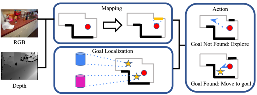
We propose a modular navigation approach, SGoLAM, composed of three components: Mapping module, Goal Localization module, and a Policy module. The overview of our approach is visualized in Figure 1. Given the agent’s pose from a noiseless GPS and Compass sensor, the mapping module creates the map of the environment by back-projecting the 3D coordinates from the current depth observation. The Goal Localization module detects the target objects from the current RGB observation and creates a goal map by back-projecting the aligned goal location from the depth observation. The Policy module takes in the predicted map and the agent pose from the Mapping module and goal locations from the Goal Localization module when the targets are detected. Based on the localization result, the Policy module outputs actions to explore the unseen area or to navigate to the goal locations.
3.1 Task Description
MultiON task extends the ObjectGoal navigation task, where the objective is to find multiple target objects in a given sequential order. We follow the setup from CVPR 2021 MultiON challenge(Wani et al. (2020)) . A set of three target objects are randomly sampled without replacement from 8 cylinders with identical shapes but with different colors: red, green, blue, cyan, magenta, yellow, black, white. The embodied agent is shaped with a cylindrical body of height 1.5m and radius 0.1m and is equipped with an RGB-D camera and a noiseless GPS/Compass sensor. Each episode begins with the agent randomly positioned in an unseen environment. The agent takes one of three navigational actions (Move Forward, Turn Right, and Turn Left) and indicates goal discovery by calling a Found action within 1.5m from its target object. The episode terminates with success when all goals are properly discovered or with failure if the agent incorrectly calls the Found action.
3.2 Mapping
The Mapping module maintains the agent’s position and a global occupancy map . Given a depth image , the module projects the 3D coordinates to an egocentric top-down grid map which indicates the probability of the corresponding location being vacant, occupied or unexplored at each time step. Note that and denote the size of the global and egocentric map. Based on the current agent’s pose and orientation , the egocentric map is transformed to an allocentric top-down grid map . The allocentric top-down map is overlaid on the global occupancy map from the previous time step to generate a new global occupancy map . The global map is further used in the Policy module.
3.3 Goal Localization
Given an RGB image and depth map , the Goal Localization module caches the location of target objects. To prevent redundant exploration, all target objects are localized regardless of whether or not it is the current goal. The module initiates by detecting target objects, namely colored cylinders, from the image . Regions in the image that share a similar color with the target objects are marked and further projected to form a goal map, which is a map that stores the 2D location of localized goals. Specifically, suppose that from cylinders with color , the agent must find cylinders with color . For each , pixel locations in the image that satisfy for a small constant are first marked as putative target objects. As such naive thresholding is prone to false positives, we further apply connected components labeling(Samet and Tamminen (1988)) and remove regions whose component size is below a threshold . The filtered pixel locations are stored in a goal map , instantiated as a top-down grid map, where the location of each pixel within the goal map is determined using the depth image . Note that grid maps are stored in , with each map storing the goal location for a specific target object. The goal map is further used to selecting the appropriate policy for Multi-Object Goal navigation.
3.4 Policy
The agent policy is determined in the Policy module using the occupancy map and goal map . If the current object goal is localized within , the agent plans toward the goal, and otherwise the agent performs exploration. To elaborate, suppose the current object goal is the cylinder with color . The agent first inspects the goal map corresponding to the ith object goal. If there are non-zero pixels within the map, the agent performs actions to move closer to the goal location, which is estimated as the mean pixel location of all non-zero pixels. The specific actions are planned with the D* algorithm(Stentz (1995)), which is a variant of the A* algorithm that is suitable for dynamic environments where the map constantly changes. If the map is left empty, the agent explores the environment with the frontier-based method(Yamauchi (1997)) that leverages information from until the current object goal is found. The frontier-based method is a classical method for robot navigation, where the agent is encouraged to move towards regions in the occupancy map with the largest intersections with the unexplored area. Note that both the mapping and goal localization modules operate simultaneously with the execution of agent policies. This allows SGoLAM to rapidly detect target object goals and minimize redundant exploration.
4 Experimental Results
4.1 Experimental Setup
SGoLAM is mainly implemented using PyTorch(Paszke et al. (2019)), and is accelerated with a single RTX 2080 GPU. All evaluations are performed on the Habitat simulator(Savva et al. (2019)) using the Matterport3D(Chang et al. (2017)) scenes. We set both the goal map and occupancy map size to be . Also, the threshold values used for goal localization is as follows: . We compare SGoLAM against four baselines:
NoMap(RNN): An agent that does not utilize any map information. An RNN encoder keeps track of the agent’s history, and the agent makes actions using the hidden state.
ProjNeuralMap: This agent projects image features onto a top-down grid map, and utilizes this map information for Multi-Object Goal navigation. The image features are obtained by passing RGBD observations through a pre-trained CNN.
AuxTaskMap: This agent shares the same neural network architecture as the ProjNeuralMap agent. However, it further fine-tunes the feature extractor CNN with three auxiliary tasks: goal location estimation, goal visibility estimation, and goal distance estimation. The agent is trained on these tasks in a supervised manner.
VisMemoryMap: This agent utilizes an array of memory vectors to keep track of salient past observations, similar to Memory Networks (Sukhbaatar et al. (2015)). The memory vectors are used to plan trajectories for Multi-Object Goal navigation.
4.2 Metrics
We evaluates the performance of our agent with metrics suggested for object goal navigation task and extended for Multi-Object Goal navigation task in previous work (Anderson et al. (2018a),Wani et al. (2020)).
Success: Binary indicator of success for each episode. The metric is a success if an agent calls {Found} for all target objects within a threshold distance, in a correct sequence, and within the allowed maximum steps for each episode. The episode fails if the agent reaches its maximum step without finding all three objects or incorrectly calls Found.
Progress: The proportion of object goals discovered successfully. In one object goal navigation task, progress evaluates the same metric as success.
SPL: Extended version of ‘Success weighted by Path Length’. (Anderson et al. (2018a)).
| (1) |
is the binary success indicator, is the total number of steps progressed by the agent and , the total geodesic distance from the starting position through each goal location.
PPL: Progress weighted by Path Length.
| (2) |
is a progress. , where l is the number of objects found. and are equally defined as before. The metric prevents unfair high weights on shorter trajectory between goals by weighting overall distance based on progress. PPL for one object goal navigation is equal to SPL.
4.3 Performance Analysis
| Method | Success | Progress | PPL | SPL |
|---|---|---|---|---|
| NoMap (RNN) | 0.05 | 0.19 | 0.13 | 0.03 |
| ProjNeuralMap | 0.12 | 0.29 | 0.16 | 0.06 |
| VisMemoryMap | 0.43 | 0.57 | 0.36 | 0.27 |
| AuxTaskMap | 0.57 | 0.70 | 0.45 | 0.36 |
| SGoLAM | 0.62 | 0.71 | 0.39 | 0.34 |
Quantitative comparisons with the baselines are shown in Table 1. SGoLAM performs competitively against the learning-based approaches, and SGoLAM outperforms all other methods in metrics that evaluate the overall success rate, namely success and progress. However, for metrics that also consider path efficiency (PPL and SPL), the state-of-the-art learning-based method AuxTaskMap outperforms SGoLAM. This could be attributed to the intrinsic limitations of classical planning-based navigation methods. As noted by Mishkin et al. (2019), classical methods for visual navigation tend to show higher success rates than their learning-based counterparts but produce more inefficient paths. Although such conclusions were made for point-goal navigation (Wijmans et al. (2020)), a similar conclusion could be made for Multi-Object Goal navigation. Nonetheless, the performance of SGoLAM is not far behind that of learning-based approaches without the help of training, making it amenable for fast, effective adaptation in novel environments.
5 Conclusion
In this paper, we introduced SGoLAM, a simple and modular model using classic projective geometry for Multi-Object Goal navigation. The proposed method leverages the benefits of classical navigational approaches which is generally strong and easily adaptable to new, unseen environments without any training requirements. However, this is not to say that the classical approach is the only promising direction of research over learning-based methods in navigation tasks. We believe that there is plenty of room for improvement by taking the complementary advantages of classical and learning-based methods.
References
- Abhishek Kadian* et al. [2019] Abhishek Kadian*, Joanne Truong*, A. Gokaslan, A. Clegg, E. Wijmans, S. Lee, M. Savva, S. Chernova, and D. Batra. Are We Making Real Progress in Simulated Environments? Measuring the Sim2Real Gap in Embodied Visual Navigation. In arXiv:1912.06321, 2019.
- Anderson et al. [2018a] P. Anderson, A. Chang, D. S. Chaplot, A. Dosovitskiy, S. Gupta, V. Koltun, J. Kosecka, J. Malik, R. Mottaghi, M. Savva, and A. R. Zamir. On Evaluation of Embodied Navigation Agents. jul 2018a. URL https://arxiv.org/abs/1807.06757.
- Anderson et al. [2018b] P. Anderson, Q. Wu, D. Teney, J. Bruce, M. Johnson, N. Sünderhauf, I. Reid, S. Gould, and A. van den Hengel. Vision-and-language navigation: Interpreting visually-grounded navigation instructions in real environments. In Proceedings of the IEEE Conference on Computer Vision and Pattern Recognition (CVPR), 2018b.
- Anderson et al. [2019] P. Anderson, A. Shrivastava, D. Parikh, D. Batra, and S. Lee. Chasing ghosts: Instruction following as bayesian state tracking, 2019.
- Beeching et al. [2019] E. Beeching, C. Wolf, J. Dibangoye, and O. Simonin. Deep reinforcement learning on a budget: 3d control and reasoning without a supercomputer, 2019.
- Chang et al. [2017] A. Chang, A. Dai, T. Funkhouser, M. Halber, M. Niessner, M. Savva, S. Song, A. Zeng, and Y. Zhang. Matterport3d: Learning from rgb-d data in indoor environments. International Conference on 3D Vision (3DV), 2017.
- Chaplot et al. [2020a] D. S. Chaplot, D. Gandhi, A. Gupta, and R. Salakhutdinov. Object Goal Navigation using Goal-Oriented Semantic Exploration. 2020a. URL https://arxiv.org/abs/2007.00643.
- Chaplot et al. [2020b] D. S. Chaplot, D. Gandhi, S. Gupta, A. Gupta, and R. Salakhutdinov. Learning to explore using active neural slam, 2020b.
- Deng et al. [2020] Z. Deng, K. Narasimhan, and O. Russakovsky. Evolving Graphical Planner: Contextual Global Planning for Vision-and-Language Navigation. jul 2020. URL http://arxiv.org/abs/2007.05655.
- Druon et al. [2020] R. Druon, Y. Yoshiyasu, A. Kanezaki, and A. Watt. Visual object search by learning spatial context. IEEE Robotics and Automation Letters, 5(2):1279–1286, 2020. ISSN 23773766. doi: 10.1109/LRA.2020.2967677.
- Fang et al. [2019] K. Fang, A. Toshev, L. Fei-Fei, and S. Savarese. Scene memory transformer for embodied agents in long-horizon tasks, 2019.
- Gordon et al. [2018] D. Gordon, A. Kembhavi, M. Rastegari, J. Redmon, D. Fox, and A. Farhadi. Iqa: Visual question answering in interactive environments, 2018.
- Henriques and Vedaldi [2018] J. F. Henriques and A. Vedaldi. Mapnet: An allocentric spatial memory for mapping environments. In 2018 IEEE/CVF Conference on Computer Vision and Pattern Recognition, pages 8476–8484, 2018. doi: 10.1109/CVPR.2018.00884.
- Mirowski et al. [2017] P. Mirowski, R. Pascanu, F. Viola, H. Soyer, A. J. Ballard, A. Banino, M. Denil, R. Goroshin, L. Sifre, K. Kavukcuoglu, D. Kumaran, and R. Hadsell. Learning to navigate in complex environments, 2017.
- Mishkin et al. [2019] D. Mishkin, A. Dosovitskiy, and V. Koltun. Benchmarking classic and learned navigation in complex 3d environments. CoRR, abs/1901.10915, 2019. URL http://arxiv.org/abs/1901.10915.
- Mousavian et al. [2019] A. Mousavian, A. Toshev, M. Fiser, J. Kosecka, A. Wahid, and J. Davidson. Visual representations for semantic target driven navigation, 2019.
- Oh et al. [2016] J. Oh, V. Chockalingam, S. Singh, and H. Lee. Control of memory, active perception, and action in minecraft, 2016.
- Paszke et al. [2019] A. Paszke, S. Gross, F. Massa, A. Lerer, J. Bradbury, G. Chanan, T. Killeen, Z. Lin, N. Gimelshein, L. Antiga, A. Desmaison, A. Kopf, E. Yang, Z. DeVito, M. Raison, A. Tejani, S. Chilamkurthy, B. Steiner, L. Fang, J. Bai, and S. Chintala. Pytorch: An imperative style, high-performance deep learning library. In H. Wallach, H. Larochelle, A. Beygelzimer, F. d'Alché-Buc, E. Fox, and R. Garnett, editors, Advances in Neural Information Processing Systems 32, pages 8024–8035. Curran Associates, Inc., 2019. URL http://papers.neurips.cc/paper/9015-pytorch-an-imperative-style-high-performance-deep-learning-library.pdf.
- Qiu et al. [2020] Y. Qiu, A. Pal, and H. I. Christensen. Target driven visual navigation exploiting object relationships. mar 2020. URL http://arxiv.org/abs/2003.06749.
- Ramakrishnan et al. [2020] S. K. Ramakrishnan, Z. Al-Halah, and K. Grauman. Occupancy anticipation for efficient exploration and navigation, 2020.
- Samet and Tamminen [1988] H. Samet and M. Tamminen. Efficient component labeling of images of arbitrary dimension represented by linear bintrees. IEEE Transactions on Pattern Analysis and Machine Intelligence, 10(4):579–586, 1988. doi: 10.1109/34.3918.
- Savinov et al. [2018] N. Savinov, A. Dosovitskiy, and V. Koltun. Semi-parametric topological memory for navigation, 2018.
- Savva et al. [2019] M. Savva, A. Kadian, O. Maksymets, Y. Zhao, E. Wijmans, B. Jain, J. Straub, J. Liu, V. Koltun, J. Malik, D. Parikh, and D. Batra. Habitat: A platform for embodied ai research, 2019.
- Stentz [1995] A. Stentz. The focussed d* algorithm for real-time replanning. In Proceedings of the 14th International Joint Conference on Artificial Intelligence - Volume 2, IJCAI’95, page 1652–1659, San Francisco, CA, USA, 1995. Morgan Kaufmann Publishers Inc. ISBN 1558603638.
- Sukhbaatar et al. [2015] S. Sukhbaatar, a. szlam, J. Weston, and R. Fergus. End-to-end memory networks. In C. Cortes, N. Lawrence, D. Lee, M. Sugiyama, and R. Garnett, editors, Advances in Neural Information Processing Systems, volume 28. Curran Associates, Inc., 2015. URL https://proceedings.neurips.cc/paper/2015/file/8fb21ee7a2207526da55a679f0332de2-Paper.pdf.
- Wani et al. [2020] S. Wani, S. Patel, U. Jain, A. X. Chang, and M. Savva. MultiON: Benchmarking Semantic Map Memory using Multi-Object Navigation. dec 2020. URL http://arxiv.org/abs/2012.03912.
- Wijmans et al. [2020] E. Wijmans, A. Kadian, A. Morcos, S. Lee, I. Essa, D. Parikh, M. Savva, and D. Batra. Dd-ppo: Learning near-perfect pointgoal navigators from 2.5 billion frames, 2020.
- Yamauchi [1997] B. Yamauchi. A frontier-based approach for autonomous exploration. In Proceedings 1997 IEEE International Symposium on Computational Intelligence in Robotics and Automation CIRA’97. ’Towards New Computational Principles for Robotics and Automation’, pages 146–151, 1997. doi: 10.1109/CIRA.1997.613851.
- Zhang et al. [2020] J. Zhang, L. Tai, M. Liu, J. Boedecker, and W. Burgard. Neural slam: Learning to explore with external memory, 2020.
- Zhu et al. [2016] Y. Zhu, R. Mottaghi, E. Kolve, J. J. Lim, A. Gupta, L. Fei-Fei, and A. Farhadi. Target-driven Visual Navigation in Indoor Scenes using Deep Reinforcement Learning. sep 2016. URL http://arxiv.org/abs/1609.05143.