Preprint \SetBgColorgray \SetBgOpacity0.2 \SetBgScale14 \SetBgAngle45
PREPRINT.
This is an author preprint version of the paper.
See the MPM4CPS’21 proceedings for the final version.
On the Need for Multi-Level ADS Scenarios
††thanks: The authors are supported by ERATO HASUO Metamathematics for Systems Design Project (No. JPMJER1603), JST. Funding reference number: 10.13039/501100009024 ERATO. S. Klikovits is also supported by Grant-in-Aid for Research Activity Start-up 20K23334, JSPS.
Abstract
Currently, most existing approaches for the design of automated driving system (ADS) scenarios focus on the description at one particular abstraction level—typically the most detailed one. This practice often removes information at higher levels, such that this data has to be re-synthesized if needed. As the abstraction granularity should be adapted to the task at hand, however, engineers currently have the choice between re-calculating the needed data or operating on the wrong level of abstraction. For instance, the search in a scenario database for a driving scenario with a map of a given road-shape should abstract over the lane markings, adjacent vegetation, or weather situation. Often though, the general road shape has to be synthesized (e.g. interpolated) from the precise GPS information of road boundaries. This paper outlines our vision for multi-level ADS scenario models that facilitate scenario search, generation, and design. Our concept is based on the common modelling philosophy to interact with scenarios at the most appropriate abstraction level. We identify different abstraction levels of ADS scenarios and suggest a template abstraction hierarchy. Our vision enables seamless traversal to such a most suitable granularity level for any given scenario, search and modelling task. We envision that this approach to ADS scenario modelling will have a lasting impact on the way we store, search, design, and generate ADS scenarios, allowing for a more strategic verification of autonomous vehicles in the long run.
Index Terms:
Automated Driving Systems, Scenario Model, Hierarchical ModelingI Introduction
At a time when companies such as Tesla, Baidu and Waymo continuously release newer generations of self-driving vehicles onto public roads, the need for proper verification and validation of automated driving systems (ADSs) is undeniable. As a pure hardware-in-the-loop verification is practically infeasible [1], the de-facto standard is to develop, test and verify the ADS’s decision-making software in simulated environments. Next to typical benefits such as reduced cost, parallelisation and faster-than-reality simulation speeds, such simulation-based verification is of particular interest to test the ADS’ behaviour in situations that in reality only rarely occur [2].
Scenarios, typically captured in some form of scenario description language (SDL) (e.g. CommonRoad [3], OpenSCENARIO [4], GeoScenario [5]), provide the necessary means to capture essential simulation details and describe the following five dimensions [6]: 1. road structure and geometry, 2. traffic interactions, 3. static objects, 4. weather conditions, and 5. occlusions. The SDLs’ difference lies in the supported granularity for the individual dimensions, s.t. some enable a more precise description of vehicle behaviour, while others may focus on detailed description of roads or obstacle interaction. These scenarios, collected in suites, are then used for verification and validation of ADS software.
Typically, we can distinguish three principal ways of obtaining ADS scenarios.
-
•
Harvesting, i.e. retrieving information from the “real world”, e.g. by extracting sensor and camera data or record & replay from real vehicle drives; or by using cartography sources such as Open Street Maps (OSM) to extract road and mapping information.
-
•
Generation, i.e. the creation of artificial maps or scenarios according to certain requirements and constraints.
-
•
Design, i.e. the creation of scenarios by hand using expert knowledge to create specific situations.
Evidently, these techniques can be combined, such that a harvested scenario can be adapted by an engineer by hand. Similarly, automated search-based generation techniques can be applied on a manually designed road situation e.g. to increase the likelihood of crash situations.
Nonetheless, a scenario’s source has a big impact on the abstraction level at which it is captured. For instance, it is easy to automatically harvest and capture detailed information about road shapes, lane markings and boundaries, and other observations from the sensor and camera recordings, or cartography services. When designing scenarios by hand, however, the manual editing process is typically very involved, such that it is easier to start at a higher abstraction level, providing only basic map information. Ideally, semi-automated tools (e.g. Matlab’s RoadRunner111https://www.mathworks.com/products/roadrunner.html) can be used to generate some of the missing information using e.g. existing road geometry standards and conventions, before experts continue to manually edit the scenario, and define more details.
Independent of the source, typical approaches tend to capture scenarios at fine-grained abstraction levels, storing data as detailed as possible. For instance, CommonRoad and GeoScenario both use lanelets [7] to describe the road geometry. These fractured, interconnected road lane-pieces split the driving surface and store information such as exact GPS road boundaries, adjoint and successor lanelets, road markings and signs, etc. allowing an ADS to optimally simulate the situation and realistically plan its trajectory through traffic (see Fig. 1(d)). As the granularity increases, however, oftentimes high-level information is removed or refined away along the way. In our opinion, this is where a problem of this approach lies.
Evidently, the detailed information is ideal for the precise reconstruction and simulation. Nonetheless, as scenario suites and databases grow, their organisation, querying and search become evermore important. High-level information about the scenario such as road shape, number of lanes, number and type of non-ego actors, etc. are removed and need to be re-synthesized. At best, scenario and benchmark databases such as the CommonRoad Benchmarks [8] or the SafetyPool Scenario-Database222https://www.safetypool.ai/ allow for some manual keyword-based tagging or textual description, which is clearly insufficient. We believe that every scenario should include information to dynamically switch to the most appropriate abstraction levels. This means, querying, analysing and editing should be possible on high abstraction levels (e.g. road shape, number of lanes, number of roads leading to crossings), and on low granularity levels (exact position of object and road boundaries) likewise.
In light of this vision, we propose the multi-level scenario model (MLSM), a framework that organises scenario information on different abstraction levels. The rest of this paper, introduces the details of this framework (§ II), relating it to typical scenario design use cases. Next, we take a step back and describe generic modelling activities and their relation to the framework (§ III), before focusing on one specific use case involving different scenario sources within the framework (§ IV). A specific search-based testing (SBT) case study shows the advantages of operating on appropriate abstraction levels. Finally, we share thoughts on a potential implementation (§ V) and our next steps leading to realising the MLSM.
II Multi-Level Scenario Model
In this section we describe our idea for a MLSM, that organises captured scenario information into abstraction levels. Note that due to space constraints, this paper is limited to the scenarios’ map and road structure. Evidently, the other dimensions (traffic interactions, static objects, weather conditions, occlusions) should also be modelled in a similar, consistent and hierarchical fashion. For the same reason, our attention is placed on vehicle road, meaning we may omit description of side walks and similar.
II-A Abstraction Levels
In this paper, we consider five hierarchical abstraction levels, building one upon another, increasingly adding further details and concretisation (see Fig. 2—left).
Road Network level
At the top level, a map’s road system is viewed as an abstract graph, using road crossings as nodes and roads connecting them (see Fig. 1(a)). This viewpoint enables us to pose questions about the style of intersections we might see (3-way / 4-way intersections). Additionally, important annotations such as the type of road (local road, highway), existence of bike lanes, zebra crossings are added.
Geometric level
The next level adds topological information to the graph, such that we can trace the shape of the road network (see Fig. 1(b)). This is the level where information about the number of lanes is added. The level allows us, for instance, to query the general complexity of navigation and evaluate if any lane-changing manoeuvres are potentially required at crossings. We may also introduce additional nodes, e.g. for lane-merging points and similar, if necessary.
Road level
The Road level signifies the switch from a rather abstract to a more concrete view of the road. Here the road shape (Fig. 1(c)) is extended to include specific lane geometries and annotated with road boundary information, pedestrian crossings, etc. In theory, this level could serve as the operation domain for abstract mission, manoeuvre or motion planners that do not require full information.
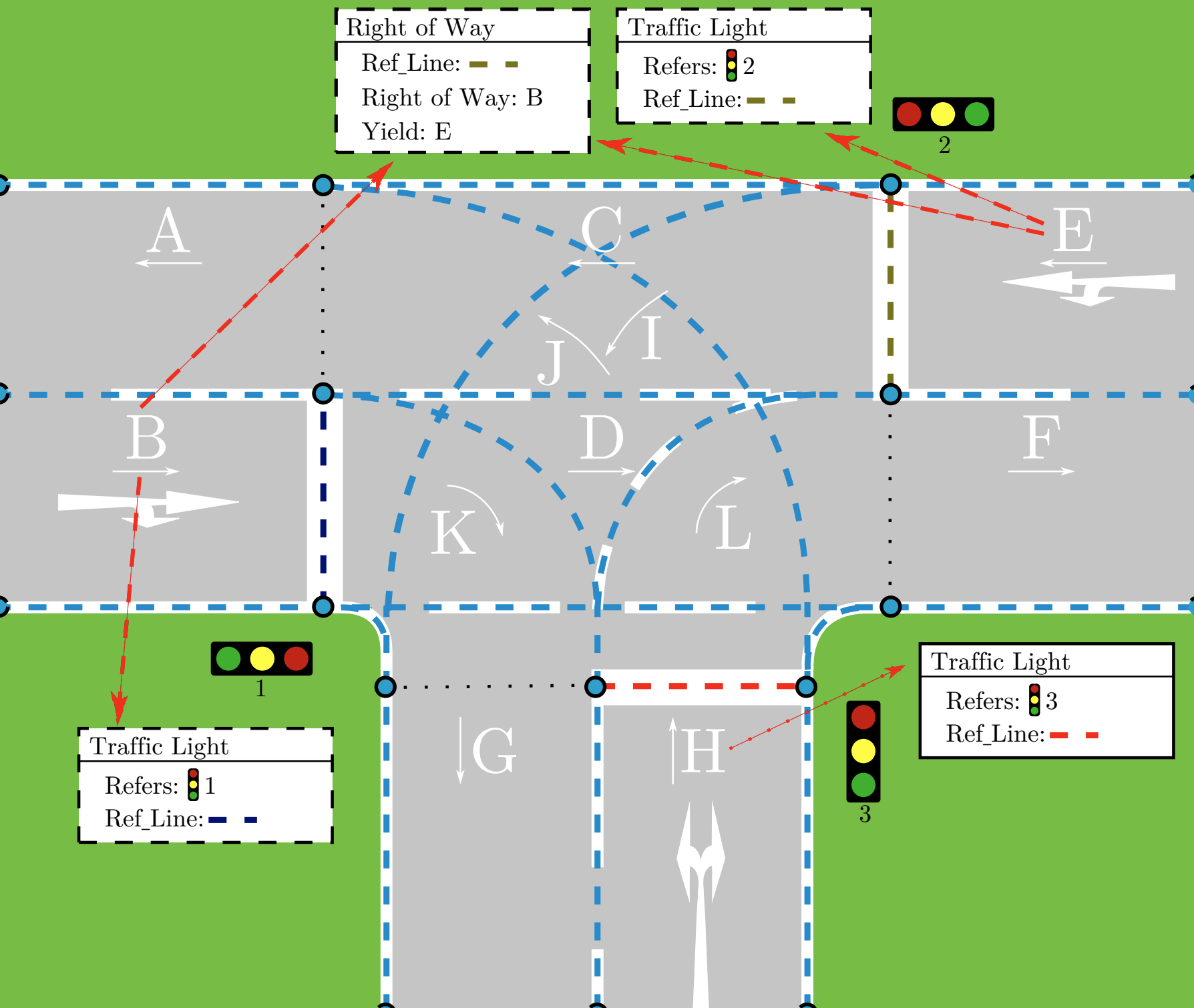
Navigation level
On the Navigation level the model is extended by particular routing and navigation information. For instance, the Lanelet2 [7] library could be used to express where and how a vehicle is allowed to move and switch lanes (see Fig. 1(d)). In the figure, each letter denotes a separate lanelet, which stores its own geometry, reference line, road signs, traffic lights, road markings, etc. Most modern ADS simulators should be able to operate at this level of granularity under the assumption that no optical perception (e.g. image recognition) is required.
Full Detail level
On the Full Detail level the model is extended to include all data for reproduction of a scenario map, including very specific information such as road surface type, road damages or potholes, and similar particularities that are abstracted over on other higher levels. Casually speaking, this is the level at which a video-game-like rendering is possible.
II-B Scenario Modelling Use Cases & MLSM
The existence of and need for different abstraction levels becomes more evident when we relate them to the individual scenario creation methods and modelling activities. Fig. 2 splits these activities by the scenario’s source. Note that the shaded boxes signify the base level at which level the information is initially provided in the source.
For instance, when we use experience harvesting to extract scenario information directly “from the road”, we can often distill very detailed information from cameras, GPS, LIDAR and RADAR sensors, etc. This means the data can be readily used for capture & replay simulations or transformed into a scenario using an SDL. Thus, the data is provided at the Full Detail level. The problem is that despite all the available information, it is rather complex to synthesize general map information from sensors. Furthermore, any data obtained through reasoning / image analysis is usually only temporarily buffered and erased immediately after use. Hence, when stored in a database or file store, it is typically impossible to ask questions about road type, road shape or query lane information. We believe that this data should be accessible (see in Fig. 2) for filtering and analysis.
Similarly, when harvesting a map from online cartography services (e.g. geographic information system (GIS) databases or OSM), information is often provided at the road level. Nonetheless, most ADS require lanelet or other road routing information for the creation of a valid mission and motion plan. In the absence of such data, it has to be either manually added, or automatically generated (see ), using the cartographic data as a source.
Alternatively, we might use search-based approaches to first create a desired road shape, which is then rendered into a lanelet network according to predefined rules (see ). This approach, situated at the Geometric level, was part of one of the 2021 SBST-Competitions333https://sbst21.github.io/tools/, whose goal was to find roads that lead a simulated automated vehicle to drive off the road before reaching the target area. Competitors used SBT methods to generate road shapes that were then enhanced and fed to an ADS simulator.
Use case shows enhancing a scenario at Navigation level to inject realistic sensor information and details such as visual information, road surface and similar for completely realistic simulation and rendering.
Another modelling task we envision is the consistency checking of generated roads. When dealing with generated information, we typically require confirmation that our data is realistic. Thus, for instance, we might compare the generated road shapes to real roads using cartographic information . Given the complexity of this geometric task, it is vital to operate on an as high abstraction level as possible.
Use case displays the complete manual design of a road, starting at the Geometric level or Road level, all the way down to the Full Detail level. The problem is that this process is very time-consuming, and we envision that typically some parts might be generated using tools such as RoadRunner. Generally, it might be easier to rely on some form of automated generation techniques, before manually editing to “smoothen the edges” and making sure the result matches the particular engineer’s expectations and constraints (see ).
III Scenario Modelling Activities
The previous section introduced several use cases and placed them in the schematics of the hierarchical MLSM according to their data source. From our viewpoint, the scenario sources and hierarchical abstraction levels implicitly create a form of grid, such that it should be possible to navigate vertically to the most appropriate abstraction for a given task. Scenarios should be consistent with one another on the same hierarchical level, independent of the data source.
This section aims to reorganise the above use cases and split them into specific scenario modelling activities. Note, that this summary is rather “academic” and we expect that, as shown above, for practical applications several activities will be merged and interwoven.
Scenario Querying
Evidently, MLSM has a significant benefit by allowing refined search queries to the scenario model. Indeed, enabling the filtering of scenarios in a database at the most appropriate level, will lead to more precise search results and enable structured cross-level queries that combine e.g. for number of roads leading to a crossing (Road Network level), general road shape and lane count (Geometric level), roads boundaries and markings, lane widths, traffic signs and regulations (Road level) and specific navigation information (Navigation level).
Scenario Adaptation & Design
The above described search functionality not only avoids unnecessary complicated searches in scenario databases, but also helps scenario designers to efficiently adapt existing scenarios. For instance, one might search a database or online cartography network for maps that are similar to the one we might design, instead of starting from scratch and creating a new one.
Scenario Refinement & Generation
By having a clearly defined hierarchy that defines the scenario granularity at each level, scenario designers can be guided through the process, making sure that the individual steps are followed. Furthermore, generation tools can be developed to tackle a specific abstraction level and provide and extend a scenario by the specific information. For instance, the transition from the Road level to the Navigation level requires the analysis of routing information for vehicles and pedestrians. On the other hand, passing from Road Network level to Geometric level, we might require information such as maximum road curvature, etc. At each level, it is then possible to perform consistency checks to make sure that the created map asserts correct properties. When an inconsistency is detected, it is possible to “step back/up” a level and adapt at a higher abstraction level.
Requirements Engineering
Another activity that could benefit from MLSM is requirements engineering (RE). When discussing about ADS requirements, a key concept is that of Operation Driving Domain (ODD) [9]. An ODD specifies the operating conditions in which the ADS should operate in terms of road characteristics, traffic characteristics, environmental elements, etc. Different ODDs can focus on different aspects and may benefit from different representations. For example, the Operational Road Environment Model (OREM) [9] represents the type of road (e.g. number of lanes) in which the ADS should drive, but does not consider elements such as traffic and environmental conditions; as such, a scenario at an intermediate level of abstraction suffices.
In the RE community, the need for managing requirements at different levels of abstraction is widely recognised [10]. Our proposed MLSM can be a suitable tool to introduce support for RE activities in the ADS domain, including specifying use cases for the different types of requirements, using the abstraction level that best matches the type of requirement.
IV Case study: Search-based testing
The current study has been developed starting from our experience in simulation-based testing of ADS, and from the issues that we faced in that domain. Therefore, we here provide a more extensive example of application of MLSM in this domain. Note that we consider MLSM for all scenario dimensions here, as explained in previous sections. We therefore assume a hierarchical model for describing e.g. other traffic participants’ behaviour, the environment, etc.
In simulation-based testing of ADS, it is known that, in order to thoroughly test some components of the ADS, reusing existing scenarios (e.g. harvested from OSM) is not enough, and that, instead, scenarios should be generated [11]. Search-based testing (SBT)is a popular technique in which the scenario generation is cast as an optimisation problem, and meta-heuristic search is used to drive the optimisation. The goal is to find scenarios exhibiting different ADS behaviours, e.g. the autonomous vehicle (AV) driving off the lane [12], the perception component failing to recognise a pedestrian [13], or the AV colliding with another vehicle [14].
SBT for ADS will greatly benefit from the proposed MLSM. Indeed, in a classical SBT approach, a developer specifies a given search space where to search for scenarios optimising the test goal: this usually consists in selecting a particular map, identifying some traffic participants (other vehicles and pedestrian), and parametrising some elements of these participants (e.g. initial position and speed) that define the search space. It is apparent that the effectiveness of SBT greatly depends on the definition of the search space, that can only be defined at the most detailed scenario level.
We envision that MLSM enables the search to explore more diverse scenarios and thus to cover more ADS behaviours. Indeed, the search space could be defined at the different levels of abstraction provided by MLSM; the search algorithm could take advantage of this representation and navigate, in a Monte Carlo Tree Search fashion, through the different abstraction levels. Let us consider, as an example, the search task of finding a scenario in which the AV drives off the road. The search algorithm could start evaluating different road maps at the higher level of abstraction, to estimate in which ones the AV has the possibility of driving off the lane, e.g. abstract scenarios with a given degree of curvature. Starting from a promising scenario selected at the most abstract level, the search could continue exploring refined scenarios derived from , containing other traffic participants, traffic signals, and so on. In these refined scenarios, the search could find the one in which the AV indeed drives off the road: for example, the search could find a scenario in which the appearance of a preceding vehicle during a turn leads the AV to suddenly break and lose control.
Note that the number of refined search spaces could be even higher. Let us assume that in the scenario found in the last step, the AV does not actually go out of the road, but just gets close to the boundary. The search space could be further refined by adding environmental elements to the search, such as rain or fog. This means, the search would also operate on another scenario dimension’s MLSM, finding that adding some fog to the previous scenario can delay the moment in which the AV recognises the preceding vehicle, so leading to an even sharper evasion manoeuvre that, in this case, leads it off the road.
V Future Work: Towards an Implementation
At the moment, our work on the MLSM framework is of theoretical nature. In collaboration with our colleagues and collaborators from within the ADS domain, we are evaluating the requirements and trying to find inconsistencies and ambiguities. Our next steps, include the finalisation of a more refined version of the framework for all five scenario dimensions. Furthermore, we are evaluating possible implementation technologies that are compatible with currently existing standards, SDLs and scenario description customs.
Our project includes the need to overcome a great deal of diversity in the field, including the different syntax and semantics of SDLs, different scenario description paradigms (descriptive, prescriptive), and the fact that the ADS domain is fast-paced with continuous release of new and change of existing standards and formats.
Currently, we try to explore, exploit and reuse existing techniques by e.g. building a scenario’s map description on well-known GIS-standards. This system already allows the definition of layered information, data import/export and the definition of constraints. Nonetheless, advanced use cases such as constraint checking, need to be efficiently integrated. We hope that our good relations to the modelling community will help us overcome (some of) the complexity and use the experience present in the domain. This includes the evaluation of e.g. domain-specific constraint languages, languages and meta-models for description of vehicle behaviour, and experiences in model serialisation and designing model databases.
VI Conclusion
This paper raises an important issue present in current automated driving system (ADS) scenario modelling, which typically leads to scenarios only being defined at the most fine-grained level of abstraction, using as much detail as possible. In the process of capturing this data, high-level information at higher abstraction levels is either not captured in the first place or removed. While a large amount of detailed information is important for realistic simulation, some tasks such as searching of scenarios in databases (e.g. by road shape) or consistency checking of generated scenarios are rendered unnecessarily complex or even impossible, as the data is at a too low abstraction level. Our work describes the need for a hierarchical multi-level scenario model (MLSM) that enables modelling at the most appropriate level of abstraction, and describes how MLSM can benefit the ADS community.
References
- [1] N. Kalra and S. Paddock, “Driving to safety: How many miles of driving would it take to demonstrate autonomous vehicle reliability?” Transportation Research Part A-policy and Practice, vol. 94, pp. 182–193, 2016.
- [2] A. Sarkar and K. Czarnecki, “A behavior driven approach for sampling rare event situations for autonomous vehicles,” in 2019 IEEE/RSJ International Conference on Intelligent Robots and Systems (IROS). IEEE, 2019, pp. 6407–6414.
- [3] M. Althoff, M. Koschi, and S. Manzinger, “Commonroad: Composable benchmarks for motion planning on roads,” 2017 IEEE Intelligent Vehicles Symposium (IV), pp. 719–726, 2017.
- [4] “Openscenario v2,” Accessed: 2021-07-30. [Online]. Available: https://www.asam.net/project-detail/asam-openscenario-v20-1/
- [5] R. Queiroz, T. Berger, and K. Czarnecki, “GeoScenario: An open DSL for autonomous driving scenario representation,” in 2019 IEEE Intelligent Vehicles Symposium (IV). IEEE, 2019, pp. 287–294.
- [6] Ilievski, Marko, “Wisebench: A motion planning benchmarking framework for autonomous vehicles,” Master’s thesis, 2020. [Online]. Available: http://hdl.handle.net/10012/16422
- [7] F. Poggenhans, J.-H. Pauls, J. Janosovits, S. Orf, M. Naumann, F. Kuhnt, and M. Mayr, “Lanelet2: A high-definition map framework for the future of automated driving,” in Proc. IEEE Intell. Trans. Syst. Conf., Hawaii, USA, November 2018. [Online]. Available: http://www.mrt.kit.edu/z/publ/download/2018/Poggenhans2018Lanelet2.pdf
- [8] M. Althoff, M. Koschi, and S. Manzinger, “Commonroad: Composable benchmarks for motion planning on roads,” in 2017 IEEE Intelligent Vehicles Symposium (IV), 2017, pp. 719–726.
- [9] K. Czarnecki, “Operational design domain for automated driving systems - taxonomy of basic terms,” Waterloo Intelligent Systems Engineering Lab (WISE), University of Waterloo, Tech. Rep., 07 2018.
- [10] S. Buhne, G. Halmans, K. Pohl, M. Weber, H. Kleinwechter, and T. Wierczoch, “Defining requirements at different levels of abstraction,” in Proceedings. 12th IEEE International Requirements Engineering Conference, 2004., 2004, pp. 346–347.
- [11] F. Hauer, A. Pretschner, and B. Holzmüller, “Re-using concrete test scenarios generally is a bad idea,” in 2020 IEEE Intelligent Vehicles Symposium (IV), 2020, pp. 1305–1310.
- [12] E. Castellano, A. Cetinkaya, C. H. Thanh, S. Klikovits, X. Zhang, and P. Arcaini, “Frenetic at the SBST 2021 tool competition,” in 2021 IEEE/ACM 14th International Workshop on Search-Based Software Testing (SBST), 2021, pp. 36–37.
- [13] R. Ben Abdessalem, S. Nejati, L. C. Briand, and T. Stifter, “Testing advanced driver assistance systems using multi-objective search and neural networks,” in Proceedings of the 31st IEEE/ACM International Conference on Automated Software Engineering, ser. ASE 2016. New York, NY, USA: ACM, 2016, pp. 63–74.
- [14] A. Calò, P. Arcaini, S. Ali, F. Hauer, and F. Ishikawa, “Generating avoidable collision scenarios for testing autonomous driving systems,” in 2020 IEEE 13th International Conference on Software Testing, Validation and Verification (ICST), 2020, pp. 375–386.