additions
Networks of UAVs of Low–Complexity for
Time–Critical Localization
Abstract
Future networks of unmanned aerial vehicles will be tasked to carry out ever–increasing complex operations that are time–critical and that require accurate localization performance (e.g., tracking the state of a malicious user). Since there is the need to preserve low UAV complexity while tackling the challenging goals of missions in effective ways, one key aspect is the UAV intelligence (UAV-I). The UAV’s intelligence includes the UAV’s capability to process information and to make decisions, e.g., to decide where to sense and whether to delegate some tasks to other network entities. In this paper, we provide an overview of possible solutions for the design of UAVs of low complexity, showing some of the needs of the UAVs for running efficient localization operations, performed either as a team or individually. Further, we focus on different network configurations, which possibly include assistance with edge computing. We also discuss open problems and future perspectives for these settings.
Index Terms:
Unmanned aerial vehicles, Localization, Policy learning, Inference engine.I Motivations
Robots could be simpler and operate longer if their computational operations, e.g., their “brains”, were delegated to external networks. But it is still an open research problem how much intelligence has to be delegated to external entities when time–critical tasks have to be accomplished. Indeed, UAVs, like robots, usually operate in uncommon situations, including natural disasters or search–and–rescue applications, where they are needed to react quickly, i.e., with the shortest possible delays. There are two major reasons why time plays a critical role for networks of UAVs: (i) the technology: UAVs can fly for a limited amount of time because of their limited battery life; (ii) the considered application: UAVs can be employed in search–and–rescue applications where targets (e.g., victims of a natural disaster) must be detected and localized as quickly as possible. Another example of challenging application is when a dense swarm, or even several swarms, of low-cost, energy constrained, and small UAVs are flown over cities for detecting and tracking non-authorized (malicious) UAVs [1, 2]. The malicious UAVs can compromise the security of the population and can be barely detected using conventional terrestrial radars. All of these examples represent time–critical localization-based applications. Indeed, with this term, we indicate all the situations when a real-time fast optimal deployment of UAVs is vitally important for the successful completion of the mission itself, as in disaster relief settings. Mission-critic applications impose strict limited mission times that should be accounted for when designing the UAV control [3].
In all such events, preserving low latency and low complexity for transmission and data processing becomes an essential requirement to limit the mission time and to make decisions quickly. In particular, the delays of each phase of the UAV mission should be optimized, i.e., during sensing, information processing, navigation, communication with peers or with cellular infrastructure. For example, peer-to-peer communications, involving shorter links between UAVs, are favorable to reduce energy consumption. However, in large swarms, it could be difficult to guarantee a full connectivity, especially when the communication range is shorter [4].
A possible solution is to partially or entirely offload some of the computations to other entities belonging to higher layers of the communication infrastructure, e.g., to the edges. This allows for keeping the complexity of the UAVs low, thus enabling network scalability. On the other hand, it presents challenging demands on the design of the UAV control [5, 2, 3]. In fact, edge-aided solutions ask for a re-design of the communication and collaboration architecture between the UAVs. In this direction, preliminary studies foresee that the sixth generation (6G) wireless networks will integrate the UAV-based flying networks within the cellular infrastructure, facilitating the connection with clouds or edges with high reliability and lower latency [6, 7].
In this paper, we study a network of autonomous UAVs with low-complexity that performs three main functional tasks: sensing, learning, and communication. The UAVs observe some features of the environment (sensing), then estimate their states (e.g., the UAV positions or some features of the surrounding) and learn which actions should be taken through interactions and experience (learning). In this sense, we refer to the UAV-I as the ability to process the information, to collaborate, and to navigate, i.e., to learn a control policy that can maximize some mission-related performance. With sensing we indicate the operation that allows UAVs to collect information from the environment. Sensing can be active, where each UAV interrogates the environment with probing signals, or passive, where the sensors measure some physical parameter. All the collected data are then processed for inferring some useful features for the considered application. For example, the UAVs estimate the positions of the targets by collecting range and angle measurements through on-board low–cost radars [5], or they optimize their positions for reducing the risk of electromagnetic field exposure [8]. The main contributions of this paper can be summarized as follows:
-
•
We discuss about how and when it is better to distribute the on–board UAV-I over high-layer entities of the network. This discussion is also corroborated by an example of complexity analysis;
-
•
We overview architectures and techniques that can be used by UAVs for improving the information processing, the communication scheme, and autonomous navigation in unknown environments, which can be critical in collaborative applications, especially when localization and tracking tasks have to be accomplished, for example, in search–and–rescue scenarios;
-
•
We provide two examples of case study to corroborate our analysis. We first address a target tracking application with a model–based information seeking control. Then, we consider a mapping and target detection application where the UAVs learn the best trajectory through trials–and–errors over episodes (model-free navigation). In both cases, time for completing the tasks is limited.
The rest of the paper is organized as follows. Section II describes the network of UAVs with low–complexity in terms of architectures and communication strategies. Then, the UAV-I for state inference is introduced in Sec. III-A and policy evaluation is presented in Sec. III-B. Finally, case studies are discussed in Sec. IV and conclusions are drawn in Sec. V.
II Networks of Low-Complexity UAVs
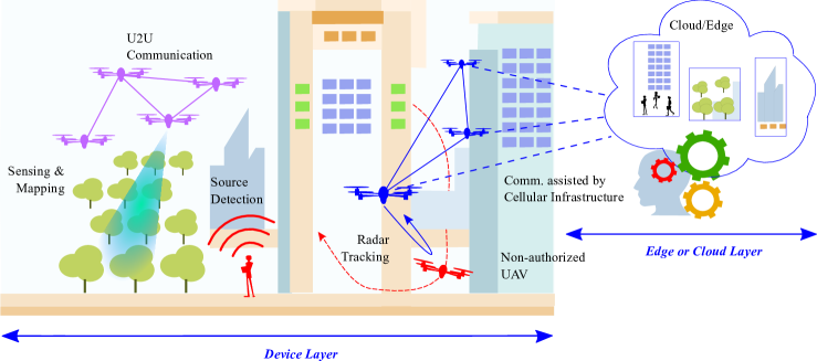
In Fig. 1, we display a couple of examples of localization-based applications. On the left, there is a swarm of UAVs dedicated to sensing and environmental monitoring in remote areas, i.e., areas difficult to reach by ground vehicles and hardly covered by a cellular network. Conversely, on the right, the swarm operates in an urban area to detect and track a non-authorized UAV, and it is assisted by an infrastructure. The network of UAVs with low-complexity, in charge of the mission, is depicted in Fig. 2. There we see the main modules of a UAV (also referred to as an agent in the sequel) with the following functionalities: (i) a Sensing Module consisting of on–board sensors designed for observing the environment; (ii) a UAV-I Module where the sensed data are processed for estimating the state of the environment and for controlling the UAV movements and communications; (iii) a Communication Module for regulating the communications with peers or with the cellular network.
UAV-I refers to the capability of a UAV to process information and to make decisions concerning sensing or delegating some tasks to other network entities. Note also that the UAV-I distribution over the network impacts the choice of the communication strategy to connect either with a peer UAV or with an edge. In fact, communication for networks of UAVs can rely either on ad-hoc device-to-device (D2D) protocols or it can be assisted by cellular networks [7]. Moreover, it can entail the exchange of sensors/measurement data (payload communication) or control and non-payload communication (CNPC) messages (e.g., sense-and-avoid commands) [4]. Payload data, like those coming from sensors, require higher data rates and longer latency to be transmitted because of their informative contents and length, while CNPC needs higher reliability because of its safety-critical contents [4].
In the following, we discuss the impact of D2D (i.e., UAV-to-UAV (U2U)) and infrastructure-based communication schemes on UAV networks. Notably, this choice does not prevent from designing networks where the two solutions are alternated depending on the needs of the considered application.
II-A U2U Network
In this kind of network, each UAV can be considered as a simple and low-complexity agent that can acquire a local knowledge of the environment through observations collected by its sensors and processing engines. When the UAV-I is fully on-UAV and not delegated to external entities, the learning task is performed locally, possibly by exchanging data with other UAVs. Thus, each UAV works with a limited set of data collected by its sensors and U2U exchanges (i.e., messages with sensed or processed data and UAV positioning information).

When working with scarce and limited information (e.g., isolated clusters of UAVs), the inference may not be accurate and the computational complexity might become an issue, especially for low-cost UAVs. On the other hand, decisions can be made much faster, and the network itself can promptly be reconfigured while becoming more fault-tolerant.
In this network scenario, data are directly exchanged among UAVs without routing them towards an infrastructure. Two possible solutions are foreseen [7]: (i) ad-hoc U2U communication that can be either in-band, or out-of-band if they exploit unlicensed bands; (ii) U2U communication with the supervision of 5G and beyond cellular infrastructure. Cellular network generations 4G LTE Release-12 and 5G already support D2D communication, enabling the connection between physically close devices through a side-link [7].
In the first solution, UAVs are not supervised and they can form clusters simply considering the shortest distance among them (e.g., via multi-hops) or according to a social-aware framework that allows them to trust each other (e.g., through advanced social graphs) [9]. In this case, the UAVs are fully responsible for setting up, controlling and coordinating the communications. This solution is important for critical applications, as in natural disasters, where the cellular infrastructure may be temporarily collapsed. In the second configuration, instead, the base stations are used for communication network management and, also, as trusted authorities to create links between the UAVs.
Notably, in both configurations, U2U communication helps in improving spectral efficiency by offloading the cellular network. This becomes of tremendous importance when a massive number of non-UAV users is simultaneously sharing the cellular infrastructure, as expected in beyond fifth generation (5G) and 6G. Moreover, it allows for improving the flexibility and for reducing the latency, when a one-hop is possible, and packet compression schemes are implemented so that the payload size is reduced.
In networks with a large number of UAVs, coverage may require multi-hop communications with the risk of the information becoming aged. In this case, to preserve low latency, some packets may be dropped and, thus, never delivered. As a result, this limits the availability of information at each UAV, which in turn might impact the accuracy of the processing and decision-making. Finally, fully U2U requires that the UAV-I is not delegated to external entities, with all the consequences they pertain to the hardware complexity, cost, and energy constraints that are typical of UAVs.
II-B UAVs Integrated with a Cellular Network
Differently from the previous scenario, here the UAVs are assisted by the existing communication infrastructure (e.g., an edge or a cloud) to offload some of the processing or to access complementary knowledge. As in a “win-win-win” strategy, the collaboration can bring benefits (i) to the communication and sensing network because the UAVs act as distributed sensors enhancing context awareness and the overall accuracy, even though offloading might impose additional load to the communication link; (ii) to UAVs if the infrastructure supports low-latency communications, and (iii) to the society at large as it enables immediate UAV communication with terrestrial users sharing the same network providing an enhanced connectivity.
In this type of architecture, the UAVs can be assisted by a remote central engine trained directly on the cloud or on the edge using data collected by the UAV sensors. This setup enables the deployment of very simple UAVs because the computation and the storage are completely delegated to the cloud/edge or to multi-access edge computing servers whose pervasive presence is fostered by the available 5G/6G BSs. The edge performs customized short-term, low-latency operations, such as local aggregation, storage and caching. Further, the edge can manage some operations which are updated based on UAV incoming messages and whose outputs can be transferred to the cloud where all long-term and longer latency operations can be performed. The UAVs still perform some simple operations: for example, they collect data through their sensors, update models, compress and encrypt model parameters to be sent out, and take some decisions.
| UAV Architectures | Advantages | Disadvantages |
|---|---|---|
| U2U | • Fully on-UAV (increased autonomy); • Enabler for faster decisions (on-board processing and control); • Fault tolerant (higher reliability); • Enabled by ad-hoc D2D or supported by 4G-5G D2D communications; • Flexible and easily reconfigurable; • Reduced latency when one-hop is possible. | • Limited information available at each UAV (local sensing); • Limited context awareness and estimation performance accuracy; • Increased complexity at the UAV side; • Increased energy consumptions; • If multi-hops are present, information can be aged or missed; |
| Integrated with the cellular network | • Enhanced context awareness; • Low latency; • UAV can leverage some processing to the edges and be more simple on-board (less complex); • UAVs are also connected with terrestrial users; • Scalability: appropriate for large swarms; | • Reduced UAV autonomy; • Vulnerability to network failures (lower reliability); • Privacy and security issues; |
| UAV Intelligence | Advantages | Disadvantages |
| Model-based optimization | • Solutions can be derived in a greedy fashion or through closed forms; • Enable quick (real–time) decisions; | • Need accurate models of the environment; • Not suitable for heterogeneous and competing tasks; • Models may not hold for fast changing environments; |
| Model-free learning | • Easy to be reconfigured based on changes of the network or of the mission goals (dynamic environments); • Suitable for heterogeneous and multiple tasks; | • Several episodes might be required (slow convergence); • Tabular methods suffer from the curse of dimensionality; |
If it is convenient to rely on the existing cellular infrastructure, several concerns should be addressed. First, one of the strongest points of the UAV technology lies in their autonomy in making decisions, for example for navigation, and in their ability to reconfigure quickly the network topology in reaction to temporary or unexpected events. If the edge takes the role of a pilot for the swarm of UAVs, the UAVs become less autonomous. Secondly, the continuous exchanges with the cloud/edge might introduce substantial data delays, if the cellular network does not support low-latency communications, which in turn leads to their less responsive control [10]. This aspect, together with the vulnerability to network/communication failures, might be extremely limiting when the UAVs are employed for emergency/surveillance situations. Privacy is yet another concern that arises when data are shared with the edge to carry out part of the computations. To avoid privacy issues, federated learning has been recently proposed as an edge-assisted learning paradigm, where only high-level learning parameters are exchanged [11].
III UAV Intelligence
In this section, we provide more insights on UAV-I and, in particular, on methods that can be used for performing mission tasks, where localization is of primary importance. As depicted in Fig. 2, the local UAV-I consists of three main blocks: (i) an inference engine that fuses the available information and estimates the state of the environment, e.g., the surroundings and the other UAVs [12]; (ii) a policy & control module that allows for learning and updating a policy, i.e., a rule, for taking decisions and actions; (iii) a short-term memory that is an internal repository of knowledge, immediately available for UAV urgent computations, especially useful in full autonomous settings. Such modules perform disjoint operations, but they are strictly intertwined according to the level of UAV autonomy. Next, we briefly describe the modules.
III-A Inference Engine
The inference problem consists of estimating the state of the phenomenon of interest from observations collected by sensors.
When the state parameters are described by a statistical model, the estimation can be performed within the Bayesian framework. In many practical cases, the state-observation pair can be represented by a probabilistic state-space model that includes [13, 14]: (i) a prior model that quantifies the initial knowledge about the state; (ii) a measurement model that relates the state to the measurements by the likelihood of the state; (iii) a transition model that represents the temporal evolution of the state. Given this state-space model, Bayesian filtering produces the predictive probability density function (pdf) of the state based on past collected measurements and, then, updates it to the filtering pdf of the state using new measurements and by applying the Bayes’ rule.
Kalman and particle filters are common methods for solving sequential estimation problems and they can also be used in a distributed manner. Probabilistic mapping is also useful to reconstruct a binary map of the environments [15]. In cooperative scenarios, all these methods can be used in a distributed manner making use of factor graphs, belief propagation or distributed particle filtering (PF) [16, 17].
III-B Policy & Control Engine
The interaction between a UAV and the environment, shown in Fig. 2, can be described under the umbrella of Markov decision processes (MDPs) or as partially observable if the state is unknown. An MDP is defined by a tuple containing the space of possible states/observations, actions and rewards, and the probability of state transition.
Notably, UAVs act as local agents, and the state represents the available knowledge about the environment. Each UAV, then, interacts with the environment through the chosen actions and, in turn, it receives rewards defined by a metric that measures the goodness and the proficiency of a taken action. In this sense, a policy is a function that maps the observations to the actions, and, hence, learning is the process that allows inferring such policy.
In the following, we discriminate between methods that rely on accurate models of the environment, solved using classical optimization techniques, from methods that learn from experience using artificial intelligence/machine learning (AI/ML) tools. Table I provides a summary of the comparison between model-based and model-free methods for policy evaluation.
Model-based methods: Classically, this problem is solved by using model-based optimization, e.g., nonlinear programming, where a single cost function or a limited set of them is minimized either in a greedy fashion or by closed-form solutions, allowing for taking quick decisions.
For example, in [3, 18] the UAV navigation problem is described as the minimization of the posterior covariance matrix on target estimation subject to UAV anti-collision and mobility constraints. In this case, the cost function to be minimized can be analytically derived because observation and transition models are both known and Gaussians. Then, to solve the problem, a projected steepest gradient descent algorithm is used whose major steps are [18]: (i) analytical derivation of the gradient of the cost function with respect to the UAV positions; (ii) computation of an initial solution with the steepest gradient descent of the cost function; (iii) derivation of the projection matrix to constrain the initial solution onto the tangent space of the potentially violated constraints; (iv) corrections to compensate for the nonlinearity effect of the constraints (nonlinearity correction); (v) derivation of the projected control for UAVs.
Unfortunately, when the dynamics of the environment is only partially known, model-based approaches might not be sufficiently accurate. In this context, machine learning (ML) techniques, i.e., model-free methods, become essential for solving a large number of heterogeneous and, sometimes, competing tasks (e.g., mission duration, storage capacity, communication requirements) [10]. However, when empirical methods are not available, ML strategies offer the possibility of inferring a policy in a data-driven way by interacting with the environment through on-board sensors and message (data) exchanges.
Model-free methods: Typical ML approaches are usually distinguished in supervised learning, that learns from a training set of labeled examples, and unsupervised learning, that extracts hidden features from unlabeled datasets. However, they do not usually consider the whole problem of an application-driven agent that interacts with an uncertain environment to maximize a reward. Instead, in reinforcement learning (RL), a third ML paradigm, the learning is carried out through interactions (“trial-and-error”) and actions are selected to maximize the sum of the discounted rewards over the future (“delayed rewards”) [12, 19].
The policy can be estimated through a direct or indirect learning approach. In direct learning, the policy is represented by a neural network with observations as inputs and actions as outputs, so that the policy is directly inferred by approximations (policy search). Thus, learning simply consists of adjusting the parameters of the neural network to find the optimal input/output relationship. Possible algorithms to perform such updates are represented by policy gradient methods [12]. Unfortunately, such methods might have slow convergence and they can be stuck on local maxima.
Differently, indirect learning is a mapping of a state-action pair into a value function, defined as the expected return, i.e., a discounted reward sequence over a certain time horizon. Since the policy should return an action to the UAV, it assesses the values for every possible action and decides either for the optimal action (exploitation) or a random one (exploration).
Implementations of this policy include approaches based on dynamic programming, Monte Carlo methods, and temporal-difference learning [12]. As an example of off-policy temporal-difference (TD) control algorithm, -learning is often used in grid-world environments with a finite set of states and possible actions [12]. The policy is learnt run-time while the UAV is navigating the environment. TD methods use a generalized policy iteration mechanism to alternatively estimate the optimal policy and the optimal -value.
The advantages of using TD methods instead of Monte Carlo or dynamic programming is that there is no need of a model for the environment’s dynamics and an update of the return is made at each time step. For discrete states and actions, the -value can be represented by a -table that, at each time instant, is updated based on the collected rewards. Obviously, the tabular approach is practical when the number of states and actions is discrete and small, while it becomes not feasible for continuous state and action spaces (due to the curse of dimensionality). In high-dimensional problems, deep RL permits to reduce their dimensionality (e.g., complexity) by exploiting the adoption of deep neural networks [12].
IV Case Studies
We now propose two examples of localization-based applications in order to provide a discussion about some of the aspects previously discussed, such as offloading the UAV-I, and the operation under the possible availability of an accurate model of the environment.
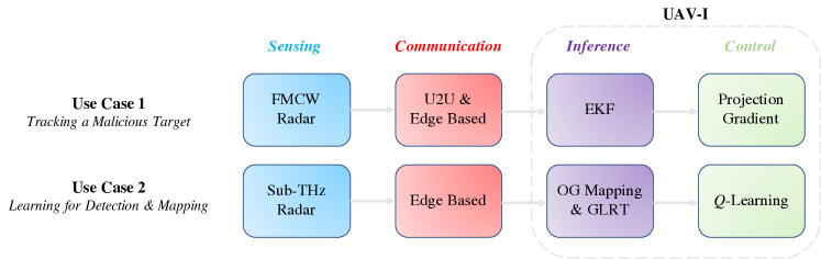
Use Case deals with the problem of tracking a malicious moving target by a swarm of UAVs, whereas, Use Case studies the exploration of an unknown environment together with the detection of a target that can be either collaborative or unintended, e.g., revealed by spectrum-sensing cognitive radio techniques. Note that, in both applications, the mission has to be completed by a given deadline. Fig. 3 depicts the implementations of the main modules at each UAV for the two use cases.
Operations Parameters State Number of Number of Dimension Measurements Constraints State Inference (EKF) Predicted state mean Quadratic - - Predicted cov. matrix Cubic - - Kalman Gain Linear Cubic - State mean Linear Linear - State covariance Quadratic Quadratic - UAV Control (Gradient-based) Nonlinearity correction Linear - Cubic Projection matrix Quadratic - Linear Projected control Quadratic - -
IV-A Use Case 1: Tracking a Malicious Target
According to Fig. 3, each UAV implements the following operations for target tracking and navigation:
-
•
Sensing: Among other sensors, each UAV is equipped with a low-cost millimeter-wave frequency modulated continuous wave (FMCW) radar collecting radar echoes in the form of range measurements. This operation cannot be offloaded to an external entity.
-
•
Communication: Each UAV can decide whether to communicate with other neighboring UAVs of the network or to be assisted by an edge. The payload data consist of the UAV ID, a timestamp, a range measurement, and the UAV position.
-
•
UAV-I: This module consists of:
-
–
Inference Module: the UAV-I runs an extended Kalman filter (EKF) for inferring the state;
-
–
Control Module: the UAV adopts a low-complexity navigation algorithm for minimizing the target localization error accounting for anti-collision constraints. In this sense, we rely on a model-based method solved using a projection steepest gradient descent algorithm.
-
–
IV-A1 Computational Complexity Analysis
We aim here at understanding the complexity for carrying out the various operations required to complete the mission for which the UAVs are responsible. This analysis is essential for deciding how to distribute the UAV-I when a network for localization-based applications is considered. Because the first two operations cannot be delegated off-board, we only focus on the computational analysis of the inference and policy learning modules. The considered EKF algorithm is composed of two major steps, the prediction, with a cubic dependence on the number of states, and the update, which has a cubic dependence on the number of measurements due to the Kalman gain derivation, and a quadratic dependence of both states and measurements in the state covariance matrix derivation (see Table II). The projection gradient algorithm for navigation is derived in closed form to reduce the complexity to only few multiplications that depend on the number of violated constraints [3].

IV-A2 Performance vs. Complexity Offloading
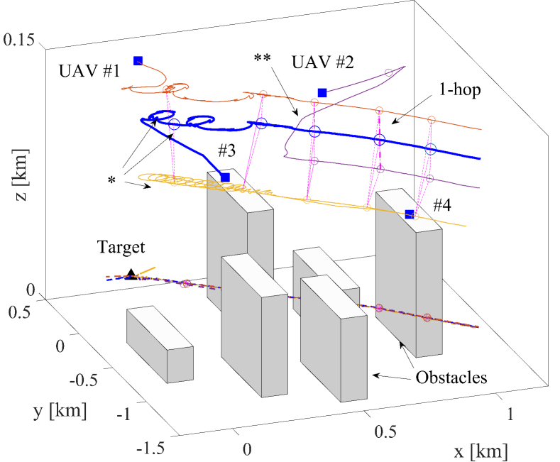
We now consider a scenario as in Figs. 4-5, where a swarm with four UAVs, with initial locations in the blue squares, tracks a target initially located in the black triangle. The actual target trajectory is displayed with a black line and the estimates of the UAVs with colored dashed lines. The same colors are also used to represent the trajectories of the UAVs.
Two different network architectures were investigated. The first was a network with fully autonomous UAVs, communicating through a multi-hop U2U scheme with a maximum communication range of km or km, and up to three hops. In this multi-hop scheme, a packet loss (PL) of was assumed. The second scheme was edge-assisted: all the sensed data were sent to the edge and, for our setting, delayed by -time steps (accounting for edge access/processing delay) and a negligible PL thanks to the high cellular network reliability. The UAV speed was varying by m/step, while the target was moving more slowly along a straight line with random accelerations and with an initial speed of m/step. This critical application required the UAVs to be capable of tracking the “malicious” target position in the shortest possible time. Note that the two adopted communication schemes affected the UAV trajectory. In fact, Fig. 4 shows that, in the U2U configurations, the UAVs followed circled trajectories, indicated with “*”, when the number of available measurements at each UAV was not sufficient to make a proper decision on navigation, and they had to rely only on their own sensed data. Moreover, UAV # was isolated during the first instants of the mission. On the contrary, when the network was fully connected with a one-hop, indicated with two stars, the UAVs flew in a team formation. The same was valid when the communication was assisted by the edge, shown in Fig. 5, where the UAVs were never isolated, and they approached the target more quickly.
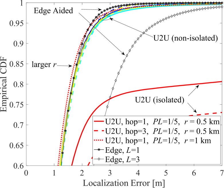
Figure 6 provides the empirical cumulative density function (CDF) defined as the number of times the absolute positioning error is lower than a desired threshold, averaged over Monte Carlo iterations and time. The localization error of the edge-assisted network was below m in almost % of cases if the cellular infrastructure guaranteed low latency (i.e., ). Conversely, with one-hop U2U communication the same accuracy could be achieved if the communication range was large enough (e.g., km). U2U schemes could be more accurate than the edge-assisted schemes if the latter introduced some delay because they processed fresh data with very low latency. However, U2U schemes might suffer from information losses in case some UAV gets isolated because of large distances. Edge-based solutions, on the other hand, can rely on more data and, thus, more information and better coverage, and they can be based on more complex computations. The price is a slower convergence to the desired localization accuracy, if the edge has high latency.
IV-B Use Case 2: Real-time Learning for Environment Mapping & Detection of a Collaborative Target
We now provide a use case for model-free UAV navigation where a swarm of UAVs navigated an unknown indoor environment with the intent to detect a target while reconstructing a map of the surrounding ambient. Such a scenario can represent a search–and–rescue situation of a cooperative target, or the detection of a malicious user that hides behind an obstacle and whose communication with other users is revealed through ad-hoc cognitive radio techniques. Note also that this analysis extends the work in [20], which is valid for only one UAV.
Operations Parameters State Number of Number of Dimension Measurements Actions State Inference (Occupancy Grid) Likelihood computation - Linear - Log-odd update Linear - - UAV Control (-Learning) for each episode Generate a random - - - Evaluation of rewards Linear - - Find the maximum (if greedy) - - Linear Update -table Linear - Linear
The main modules of Fig. 3 at each UAV were:
-
•
Sensing: For mapping purposes, a sub- Terahertz (THz) multi-antenna radar collecting a range-angle (energy) observation matrix was embedded on-board the UAVs.
-
•
Communication: The communication only took place with an edge for sharing some learning parameters and offloading some processing related to decision–making for UAV navigation.
-
•
UAV-I: For this module, we had
-
–
Inference: In the considered example, the UAV-I ran two algorithms: (i) an occupancy grid (OG) for mapping and a generalized likelihood ratio test (GLRT) for target detection [20];
- –
-
–
IV-B1 Computational Complexity Analysis
Table III summarizes the complexity of the inference and control modules of Use Case 2. We assumed that the GLRT is less complex with respect to the implemented occupancy grid in terms of operations (e.g., it can be implemented with a look-up table according to the signal-to-noise ratio (SNR)), and thus we report the complexity in terms of number of measurements and states (i.e., of the number of cells in which the environment is discretized). Further, we assume that the map belief does not account for inter-cell correlations. Finally, the -learning also depends on the number of episodes needed to achieve the final state [21]. Although the main operations have a linear dependence on the state dimension, the number of cells can be huge, even greater than states for large indoor environments. Hence, with low-complexity UAVs, it would not be feasible to perform state estimation or the -table update exclusively on-board.
IV-B2 Performance vs. Learning Time
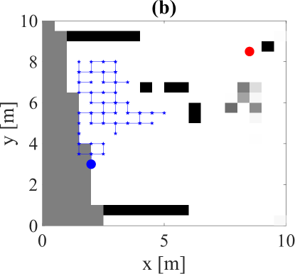
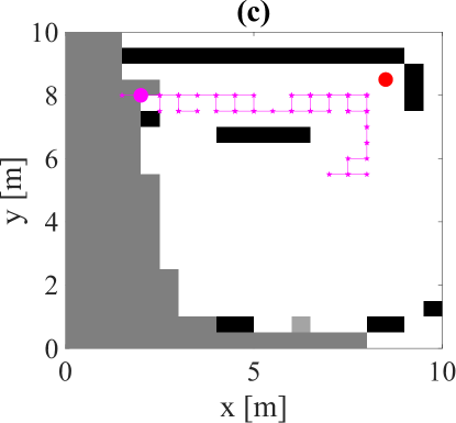
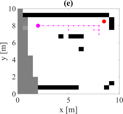
We now describe the mapping and detection performance of a network of two UAVs moving in an environment depicted in Fig. 7-(a). The UAVs were initially assumed to be in positions m and m (blue and magenta markers of Fig. 7-(a)), respectively, and they moved with steps of m, equal to the cell width. The task of the network was to detect the target located on the upper east side of the map, in m, and depicted with a red marker. Mapping of the environment is functional to the realization of this task.
Since each UAV was equipped with a sub–THz radar working at GHz, the observation model accounted for the THz scattering model of [22, 20]. In particular, we set a scattering coefficient to (rough surface), the length of the scattering object to , and the width of the scattering lobe to [22]. We considered an effective isotropic radiated power (EIRP) of dBm, a receiver noise figure of dB, and GHz signal bandwidth. The mapping was performed by a radar equipped with an array of antennas with steering directions for a (semi–plane) scan of the environment. For other mapping parameters, we refer to [20].


For the detection task, we considered an antenna with dBi gain, a reading range of m and a target always present in the environment. A GLRT was used to decide whether the target is present or not with a threshold accounting for a desired false alarm probability of [20]. We fixed the mission time and the number of episodes to and , whereas the discount and learning rates to and , respectively. We adopted a -decay strategy where the probability of taking a random action decreased with time.
In regards to inter–UAV coordination, the problem of multi-agent RL has already been deeply investigated in [12]. Following our analysis on computational complexity, it was evident that the control, i.e., the store and the update of the -table, should be delegated to the edge. In fact, given the high-dimensional representation of the environment and the presence of multiple UAVs with different views of it, the edge served as a leader in fusing the received information, in storing and updating a global -table. Thanks to this centralized approach, both agents had better ambient awareness and they could infer a global policy according to -learning.
Figure 7 shows the UAV trajectories with blue and magenta markers for the two UAVs, and for the first and last episodes. As expected, the UAV named “A”, whose position was closer to the target, got sooner to the destination position but with a scarce map reconstruction. By contrast, the UAV “B” was capable of reconstructing a better copy of the map, and of finding a good trajectory after some training episodes thanks to the aid offered by the other UAV.
Note also that both agents were not efficient during the first episode (Fig. 7-(b,c)). This implies that if the task has to be accomplished only in one episode, the swarm might not correctly accomplish the goal of the mission.
Finally, Fig. 8 shows the behavior of the positive -values (e.g., positive rewards received from the environment) as a function of the number of episodes and averaged over ten simulations. Notably, when multiple UAVs update a common -table, the time needed in terms of episodes to achieve a greater amount of positive rewards (i.e., a better knowledge of the environment) is less than that required by a single agent. This result confirms that the employment of many coordinated UAVs allows to accelerate the learning procedure and, thus, to enable the exploration of large environments. On the other side, when the network is composed of many UAVs, the consequent communication burden with the edge should be accounted for.
V Conclusions & Future Perspectives
It is clear that UAVs present a wide range of requirements: they need to be autonomous, fast, multi-tasking, and intelligent. But, above all, they should preserve a low complexity implementation while accurately accomplishing the mission for which they have been deployed. Consequently, the on-board UAV-I needs to be properly designed and, when necessary, delegated to a higher entity of the network thanks to a communication scheme enabling such distribution. In this sense, even if the performance of the case studies depends on the specific set-up, some general conclusions can be drawn.
V-1 Final Remarks on Communication
In Use Case 1, we compared a case in which UAVs lean on an edge and one with multi-hops. In the edge scenario, the availability of a global view of the environment naturally improves the accuracy of the estimate, but the performance depends on the latency due to access and processing delays. Indeed, the presence of aged measurements might lead to an old view of the state of the system, especially in fast-changing environments.
In the case with multi–hops, the delays are dictated by the connections created at each time instant between the nodes. Therefore, if the network is small and can be connected with a single-hop, it allows for processing of all sensed data, as for an edge-aided network, with the advantage of being less vulnerable. The downside is that some UAVs could be isolated without receiving any information from the other UAVs, creating very high localization errors and inducing higher latency in finding a good flying formation.
V-2 Final Remarks on Navigation
In this paper we have provided two trajectory design schemes for the UAV network, a gradient-based and a learning-based method. The first approach is certainly faster and allows, after a few instants, to obtain the desired UAV formation. By contrast, the second approach requires a longer learning time (e.g., different training episodes). The first approach is good when there is a model of the function that we want to optimize but is subject to modeling errors. For example, based on the chosen communication scheme, the model could be affected by delayed information (e.g., coming from multi-hop measurements) or inaccurate position estimates. The second approach is more robust to model mismatches and can be accelerated thanks to collaboration among the UAVs or with the edge.
V-3 Final Remarks on Complexity
With Use Case 1 we have evidenced that, even for a low-dimensional state, the edge can help in reducing the time required for finding the best swarm formation for getting closer to a target. This aspect can be crucial when the available time is limited and, thus, the off-load of computations might be for low-dimensional states. Note that the application itself drives the design of the UAV-I: for example, relying on edges for mission–critical applications could be fatal due to network vulnerability to external attacks. In fact, if the edge is hacked by an external user, the entire network will not be capable to perform the assigned task in safe conditions. Moreover, if the UAVs are used in post-disaster situations, the edges (e.g., the cellular infrastructure) might not be accessible. Also, to further reduce delays, it is recommended not to delegate anti-collision operations to external nodes.
Similarly, in Use Case 2, we highlighted that dealing with a large –table might be complicated for low-complexity UAVs. Such operations should be delegated to an edge, with consequent privacy and security issues.
V-4 Final Remarks on Network Scalability
Because time is a critical resource, the acceleration of the learning procedure is an intrinsic task for future swarms of UAVs. In this sense, apart from the adoption of more performing learning algorithms, cooperation and coordination techniques for UAVs can be of great help for speeding up the process, especially in scenarios where the rewards are sparse in the environment. On the other side, this implies an increase of hardware complexity and of coordination among UAVs which have to interact between each other and eventually with the edge.
V-5 Future Perspectives
In future autonomous networks, teams of UAVs are expected to be capable to self-evaluate the goodness of their performance through a measure of proficiency. Such metric, together with received environmental feedback, will provide an important assessment to each UAV to optimize the performance and re-assess each time when new observations are acquired.
A step ahead of the self-assessment is represented by situation-awareness, which accounts for information about the context in which the UAVs accomplish their tasks. In this direction, one possibility is to dynamically adapt the communication scheme according to the needs and conditions experienced during the UAV flight time. In this light, future generations of UAV networks will exploit the UAV-I to control the communication scheme by alternating the destinations based on different time-varying requirements (e.g., offloading the computation or preserving low latency).
Finally, in our case study we have experienced that the independent design of sensing and communication might not be flexible enough to simultaneously satisfy the needs of the application because the control dictates the most stringent communication requirements to attain some sensing performance but not vice-versa. From this point of view, a co-design is preferable to jointly maximize a twofold communication and sensing performance, even if it may be particularly challenging as their requirements often contrast with each other. In this sense, further coexistence problems arise when they simultaneously take place in the same frequency bands. For example, ML can be adopted for picking the best UAV trajectories while optimizing the sensing and communication parameters.
References
- [1] J. Wang, Y. Liu, and H. Song, “Counter-unmanned aircraft system(s) (C-UAS): State of the art, challenges, and future trends,” IEEE Aerosp. Electron. Syst. Mag., vol. 36, no. 3, pp. 4–29, 2021.
- [2] I. Guvenc et al., “Detection, tracking, and interdiction for amateur drones,” IEEE Commun. Mag., vol. 56, no. 4, pp. 75–81, 2018.
- [3] A. Guerra, D. Dardari, and P. M. Djurić, “Dynamic radar network of UAVs: A joint navigation and tracking approach,” IEEE Access, vol. 8, pp. 1–1, 2020.
- [4] Y. Zeng, Q. Wu, and R. Zhang, “Accessing from the sky: A tutorial on UAV communications for 5G and beyond,” Proc. IEEE, vol. 107, no. 12, pp. 2327–2375, 2019.
- [5] A. Guerra, D. Dardari, and P. M. Djurić, “Dynamic radar networks of UAVs: A tutorial overview and tracking performance comparison with terrestrial radar networks,” IEEE Veh. Technol. Mag., vol. 15, no. 2, pp. 113–120, 2020.
- [6] W. Saad, M. Bennis, and M. Chen, “A vision of 6G wireless systems: Applications, trends, technologies, and open research problems,” IEEE Netw., pp. 1–9, 2019.
- [7] P. Popovski et al., “Wireless access for ultra-reliable low-latency communication: Principles and building blocks,” IEEE Netw., vol. 32, no. 2, pp. 16–23, 2018.
- [8] Z. Lou, A. Elzanaty, and M.-S. Alouini, “Green tethered UAVs for EMF-aware cellular networks,” arXiv preprint arXiv:2105.14359, 2021.
- [9] N. Saxena, F. H. Kumbhar, and A. Roy, “Exploiting social relationships for trustworthy D2D relay in 5G cellular networks,” IEEE Commun. Mag., vol. 58, no. 2, pp. 48–53, 2020.
- [10] V. Kouhdaragh et al., “On the application of machine learning to the design of UAV-based 5G radio access networks,” Electronics, vol. 9, no. 4, p. 689, 2020.
- [11] F. Yin et al., “FedLoc: Federated learning framework for data-driven cooperative localization and location data processing,” IEEE Open J. Signal Process., 2020.
- [12] D. Lee et al., “Optimization for reinforcement learning: From a single agent to cooperative agents,” IEEE Signal Process. Mag., vol. 37, no. 3, pp. 123–135, 2020.
- [13] F. Gustafsson, “Particle filter theory and practice with positioning applications,” IEEE Aerosp. Electron. Syst Mag., vol. 25, no. 7, pp. 53–82, 2010.
- [14] J. Duník et al., “State estimation methods in navigation: Overview and application,” IEEE Aerosp. Electron. Syst. Mag., vol. 35, no. 12, pp. 16–31, 2020.
- [15] S. Thrun, “Probabilistic robotics,” Commun. ACM, vol. 45, no. 3, pp. 52–57, 2002.
- [16] D. Dardari, P. Closas, and P. M. Djurić, “Indoor tracking: Theory, methods, and technologies,” IEEE Trans. Veh. Technol., vol. 64, no. 4, pp. 1263–1278, 2015.
- [17] M. Z. Win et al., “Network localization and navigation via cooperation,” IEEE Commun. Mag., vol. 49, no. 5, pp. 56–62, 2011.
- [18] S. Zhang et al., “Self-aware swarm navigation in autonomous exploration missions,” Proc. IEEE, vol. 108, no. 7, pp. 1168–1195, 2020.
- [19] A. M. Ahmed et al., “A reinforcement learning based approach for multi-target detection in massive MIMO radar,” IEEE Trans. Aerosp. Electron. Syst., pp. 1–1, 2021.
- [20] A. Guerra et al., “Real-time learning for THz radar mapping and UAV control,” in Proc. IEEE Conf. Autonomous Syst. (ICAS), 2021, pp. 1–5.
- [21] S. Koenig and R. G. Simmons, “Complexity analysis of real-time reinforcement learning,” in AAAI, 1993, pp. 99–107.
- [22] S. Ju et al., “Scattering mechanisms and modeling for terahertz wireless communications,” in Proc. IEEE Int. Conf. Commun., 2019, pp. 1–7.