GeoVectors: A Linked Open Corpus of OpenStreetMap Embeddings on World Scale
Abstract.
OpenStreetMap (OSM) is currently the richest publicly available information source on geographic entities (e.g., buildings and roads) worldwide. However, using OSM entities in machine learning models and other applications is challenging due to the large scale of OSM, the extreme heterogeneity of entity annotations, and a lack of a well-defined ontology to describe entity semantics and properties. This paper presents GeoVectors – a unique, comprehensive world-scale linked open corpus of OSM entity embeddings covering the entire OSM dataset and providing latent representations of over 980 million geographic entities in 180 countries. The GeoVectors corpus captures semantic and geographic dimensions of OSM entities and makes these entities directly accessible to machine learning algorithms and semantic applications. We create a semantic description of the GeoVectors corpus, including identity links to the Wikidata and DBpedia knowledge graphs to supply context information. Furthermore, we provide a SPARQL endpoint – a semantic interface that offers direct access to the semantic and latent representations of geographic entities in OSM.
Resource type: Dataset
Documentation: http://geovectors.l3s.uni-hannover.de
Dataset DOI: https://doi.org/10.5281/zenodo.4339523
1. Introduction
OpenStreetMap (OSM) has evolved as a critical source of openly available volunteered geographic information (Arsanjani et al., 2015). The amount of information available in OpenStreetMap is continuously growing. For instance, the number of geographic entities captured by OSM increased from in March 2020 to in March 2021. Today, OSM data is used in a plethora of machine learning applications such as road traffic analysis (Keller et al., 2020), remote sensing (Vargas et al., 2020), and geographic entity disambiguation (Tempelmeier and Demidova, 2021). Other data-driven OSM applications include map tile generation (Haklay and Weber, 2008) and routing (Huber and Rust, 2016).
OpenStreetMap is a collaborative online project that aims to create a free and editable map and features over 7.6 million contributors as of June 2021. OSM provides information about its entities in the form of key-value pairs, so-called tags. For instance, the tag place=city indicates that an entity represents a city. OSM tags and keys do not follow any well-defined ontology or controlled vocabulary. Instead, OSM encourages its contributors to follow a set of best practices for annotation111https://wiki.openstreetmap.org/wiki/Any_tags_you_like. The number of tags and the level of detail for individual OSM entities is highly heterogeneous (Touya and Reimer, 2015). For instance, as of June 2021, the size of data available for the country of Germany sums up to 3.3 GB, while only 2.5 GB of data is available for the entire South American continent. Ultimately, factors including 1) a varying number of tags and details for specific geographic entities, 2) the lack of a well-defined ontology resulting in numerous tags with unclear semantics, and 3) missing values for any given property, substantially hinder the feature extraction for broader OSM usage in machine learning applications.
A central prerequisite to facilitate the effective and efficient use of geographic data in machine learning models is the availability of suitable representations of geographic entities. Recently, latent representations (embeddings) have been shown to have several advantages in machine learning applications, compared to traditional feature engineering, in a variety of domains (Liu et al., 2018; Xie et al., 2016; Wang and Li, 2017). First, embeddings can capture semantic entity similarity not explicitly represented in the data. Second, embeddings facilitate a compact representation of entity characteristics, overall resulting in a significant reduction of memory consumption (Tempelmeier and Demidova, 2021). Whereas much work has been performed to provide pre-trained embeddings for textual data and knowledge graphs (Wang et al., 2020, 2017a), only a few attempts, such as (Kejriwal and Szekely, 2017), aimed to provide such latent representations for geographic entities and captured selected entities only. From the technical perspective, the creation of OSM embeddings is particularly challenging due to the large scale of OSM (more than 1430 GB of data as of June 2021222https://wiki.openstreetmap.org/wiki/Planet.osm) and the OSM data format (“protocolbuffer binary format”333https://wiki.openstreetmap.org/wiki/PBF_Format), requiring powerful computational infrastructure and dedicated data extraction procedures. Furthermore, the semi-structured data format of OSM tags requires specialized embedding algorithms to capture the semantics of entity descriptions. As a result of these challenges, currently, no datasets that capture latent representations of OSM entities exist.
The GeoVectors corpus of embeddings presented in this paper is a significant step to enable the efficient use of extensive geographic data in OSM by machine learning algorithms. GeoVectors facilitates access to these embeddings using semantic technologies. We utilize established representation learning techniques (word embeddings and geographic representation learning) to capture various aspects of OSM data. We demonstrate the utility of the GeoVectors corpus in two case studies covering the tasks of type assertion and link prediction in knowledge graphs. GeoVectors follows the 5-Star Open Data best practices in data publishing and reuses existing vocabularies to lift OpenStreetMap entities into a semantic representation. We provide a knowledge graph that semantically represents the GeoVectors entities and interlinks them with existing resources such as Wikidata, DBpedia, and Wikipedia. With the provision of pre-computed latent OSM representations, we aim to substantially ease the use of OSM entities for machine learning algorithms and other applications.
To the best of our knowledge, currently, there are no dedicated resources that provide extensive reusable embeddings for geographic entities at a scale comparable to GeoVectors. The absence of comprehensive geographic data following a strict schema makes it particularly challenging to process geographic data in machine learning environments. We address these problems by providing models capable of embedding arbitrary geographic entities in OSM. Moreover, we enable easy reuse by making both models and encoded data publicly available.
The main contributions of this paper are as follows:
-
•
We provide GeoVectors – a world-scale corpus of embeddings covering over 980 million geographic entities in 188 countries using two embedding models and capturing the semantic and the geographic dimensions of OSM entities.
-
•
We introduce an open-source embedding framework for OSM to facilitate the reusable embedding of up-to-date entity representations444https://github.com/NicolasTe/GeoVectors.
-
•
We provide a knowledge graph to enable semantic access to GeoVectors.
The remainder of this paper is organized as follows. In Section 2, we discuss the predicted impact of GeoVectors. Then, in Section 3, we present the embedding generation framework. In Section 4, we present the GeoVectors knowledge graph. Next, we describe the characteristics of the GeoVectors corpus in Section 5. We illustrate the usefulness of GeoVectors in two case studies in Section 6 and discuss availability and utility in Section 7. In Section 8, we discuss related work. Finally, in Section 9, we provide a conclusion.
2. Predicted Impact
GeoVectors is a new resource. This section discusses the predicted impact of GeoVectors regarding the advances of state of the art in geographic embedding datasets, geographic information retrieval, machine learning applications, knowledge graph embeddings and broader adoption of semantic web technologies.
Advances of the state of the art: We advance the state of the art by providing the first large-scale corpus of pre-trained geographic embeddings. We carefully select established representation learning techniques to capture both the semantic dimension (What entity type does the OSM entity represent?) and the spatial dimension (Where is the entity located?) and adapt these techniques to OSM data to create meaningful latent representations. The GeoVectors corpus is the first dataset that captures the entire OpenStreetMap, thus offering the data on the world scale. Therefore, GeoVectors is significantly larger than any existing geographic embedding resources. For instance, the Geonames embedding (Kejriwal and Szekely, 2017) provides a dataset containing less than 358 thousand entities, whereas GeoVectors contains over 980 million entities.
Impact on geographic information retrieval: Geographic information retrieval (GIR) addresses the problems of developing location-aware search systems and addressing geographic information needs (Purves et al., 2018). Recent GIR approaches build on geographic embeddings to address several use cases, including tag recommendation for urban complaint management (Gao et al., 2019), geographic question answering (Contractor et al., 2021), and POI categorization (Tsubouchi et al., 2020). While these approaches demonstrate the utility of geographic embeddings for GIR tasks, the laborious generation process hinders the adaption of geographic embeddings for other GIR tasks such as geographic named entity recognition, next location recommendation, or geographic relevance ranking. In this context, the availability of large-scale and accessible geographic embeddings is a vital prerequisite to stimulate research in the GIR field. The GeoVectors corpus presented in this paper addresses these requirements by providing ready-to-use geographic embeddings of the entire OpenStreetMap.
Impact on machine learning applications: Existing machine learning applications use geographic data to address numerous use cases including location recommendation (Liu et al., 2018; Xie et al., 2016), human mobility prediction (Wang and Li, 2017), and travel time estimation (Wang et al., 2021). The variety of use cases highlights the general importance of geographic information for machine learning models. However, these approaches conduct a costly feature extraction process or learn supervised embeddings of geographic entities on task-specific datasets for specific tasks. In this context, the availability of easy-to-use representations of geographic entities at scale provided by GeoVectors is crucial to enabling and easing the further development of geographic machine learning models and geographic algorithms.
Impact on knowledge graph embeddings: Knowledge graph embeddings generated without the specific focus on geographic entities have shown success in a large variety of knowledge graph inference and enrichment tasks, including type assertions and link prediction (Paulheim, 2017). We envision that GeoVectors can further enhance the quality of embeddings used in the context of these tasks: While geographic entities are part of many popular knowledge graphs such as Wikidata and DBpedia, their specific characteristics are still rarely considered. Existing approaches typically focus on the graph structure, but rarely on the property values assigned to the single nodes (Kristiadi et al., 2019). However, both tags and coordinates of geographic entities bear valuable semantics. Specifically, the geographic interpretation of coordinates may heavily lift the role of coordinates in knowledge graph embeddings. In the future, the GeoVectors embeddings can directly support knowledge graph inference and enrichment and creation of geographically aware embeddings from other sources.
Impact on adoption of semantic web technologies: In the context of the Semantic Web, a variety of models and applications, including link prediction, creation of domain-specific knowledge graphs (Gottschalk and Demidova, 2019) and Question Answering for event-centric questions (Costa et al., 2020) make use of geographic data. Semantic technologies have been applied to a variety of domains that require spatio-temporal data, including crime localization, transport data, and historical maps (Rollo and Po, 2020; Scrocca et al., 2020; Shbita et al., 2020). Furthermore, with the increased availability of mobile devices, location-based algorithms such as next location recommendation or trip planning evolved. Recently, SPARQL extensions for integrated querying of semantic and geographic data have been proposed (Homburg et al., 2020). In this context, the availability of easy-to-use representations of geographic entities at scale is crucial to enable further development of semantic models and geographic algorithms and their adoption in real-world scenarios. Increasing availability of geographic data accessible through semantic technologies, as facilitated by GeoVectors, and seamless integration of this data with other semantic data sources in the Linked Data Cloud can attract interested users from various disciplines and application domains, including geography, mobility, and smart cities.
3. GeoVectors Framework for Embedding Generation
The GeoVectors framework facilitates the generation of OSM embeddings that capture geographical (GV-NLE) and semantic (GV-Tags) similarity of OSM entities. In this section, we first describe the OSM data model. Then, we provide an overview of the GeoVectors embedding generation process and present embedding algorithms that generate the proposed GV-NLE and GV-Tags embeddings.
3.1. OpenStreetMap Data Model
The OSM data model distinguishes three entity types: nodes, ways and relations.
-
•
Nodes represent geographic points. A pair of geographic coordinates gives the point location. Examples of nodes include city centers and mountain peaks.
-
•
Ways represent entities in the form of a line string, e.g., roads. Ways aggregate multiple nodes that describe the pairwise segments of the line string.
-
•
Relations represent all other aggregated geographic entities. Relations consist of a collection of arbitrary OSM entities to form, for instance, a polygon. Examples of relations include country boundaries and train routes.
Each OSM entity can have an arbitrary number of annotations called tags. Tags are key-value pairs that describe entity features. For example, the tag place = city indicates that a particular OSM entity represents a city. More formally, an OSM entity consists of an identifier , a , and a set of tags . An OSM snapshot taken at a time in a region is denoted by , where is a set of OSM entities within the specified region at this time.
3.2. GeoVectors Embedding Generation Overview
The GeoVectors embeddings reflect semantic and geographic relations of OSM entities, where semantic relations capture semantic entity similarity, expressed through shared annotations, and geographic relations capture geographic entity proximity. In general, the relevant relation type is application-dependent. Therefore, we compute two embedding datasets, one capturing geographic and the other semantic similarity of OSM entities:
-
•
(1) GV-NLE is our geographic embedding model based on the Neural Location Embeddings (NLE) (Kejriwal and Szekely, 2017) – an approach to capture the spatial relations of geographic entities.
-
•
(2) GV-Tags is our semantic embedding model based on fastText (Joulin et al., 2017) – a state-of-the-art word embedding model that we apply on the OSM tags.
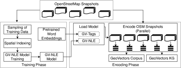
The embedding generation process that takes as input a set of OSM snapshots and generates the GeoVectors corpus and the GeoVectors knowledge graph is illustrated in Figure 1. We divide this process into the training phase in which we train the GV-NLE model and the encoding phase in which we apply embedding models to encode OSM entities.
The training of an embedding model is typically significantly more expensive than the application of the model. Due to the large scale of OpenStreetMap (as of June 2021, OSM contains more than 7 billion entities), the training of embedding models on the entire corpus is not feasible. Therefore, in the training phase, we sample a subset of OSM entities from OSM snapshots to serve as training data. We discuss the sampling process in Section 3.3. Based on the sampled data, we train our embedding models. To generate semantic embeddings, we utilize existing pre-trained word embedding models.
In the encoding phase, we first load the trained embedding model and then pass all individual entities from an OSM snapshot to the model. The application of the model can be parallelized by applying the model to each snapshot separately. The model encodes the OSM entities and stores the generated embedding vectors into an easily processable, tab-separated value file.
We provide an open-source implementation of the embedding framework, including the pre-trained embedding models555https://github.com/NicolasTe/GeoVectors. This framework enables the computation of up-to-date embeddings of individual OpenStreetMap snapshots. We also generate the GeoVectors knowledge graph that enables semantic access to GeoVectors and is described in detail in Section 4.
We performed the entire extraction and embedding process on a server with 6 TB of memory and 80 Intel(R) Xeon(R) Gold 5215M 2.50GHz CPU cores. Our framework required about four days for data extraction, model training, and data encoding.
3.3. Sampling of OSM Training Data for Embedding Algorithms
At the beginning of the training phase, we extract a representative entity subset to use as a training set. To ensure representativeness, we employ the following conditions: First, the training set should have a balanced geographic distribution to avoid biases towards specific geographic regions. Second, the training set should only include meaningful OSM entities. For instance, many OSM nodes do not provide any tags and only represent spatial primitives for composite entities, such as ways and relations. Such nodes do not correspond to real-world entities and, taken isolated, do not convey any meaningful information. Therefore, we exclude nodes without tags from the training data.
| Input: | OpenStreetMap snapshots | |
| Minimum number of training examples | ||
| Output: | Set of training examples |
Algorithm 1 presents the sampling process to obtain training data. The input of the algorithm consists of a minimum number of training samples to be collected and a corpus of OpenStreetMap snapshots (e.g., country-specific snapshots). First, we calculate the total geographic area covered by all snapshots using the function (line 1), where denotes the region of the OSM snapshot . To enforce a uniform geographic distribution, we calculate the number of samples extracted from a single snapshot regarding its geographic size. For each snapshot, we determine the number of samples to be extracted proportionally to the geographic area of the snapshot (line 4). Then, the scan_snapshot function divides the snapshot into linked, tagged and other entities (line 5). Linked entities provide an identity link to external datasets. As identity links typically indicate good data quality, our algorithm includes all linked entities. Tagged entities provide at least one tag. Other entities are entities that neither provide an identity link nor a tag. Next, the algorithm samples all linked entities (even if their number exceeds ) into the result set (line 6). If the size of does not reach , the function sample uniformly selects at maximum random samples from the tagged entities (lines 7-9). If is still not reached, we sample the remaining examples from the other entities (lines 10-12). Finally, the algorithm returns the union of all snapshot-specific training examples (lines 13-15).
3.4. GV-NLE Embedding of OSM Entity Locations
The GV-NLE model builds on the neural location embedding (NLE) model (Kejriwal and Szekely, 2017) that captures the geographic relations of a set of geographic entities in a latent representation. The NLE method is an established method to create reusable geographic embeddings. GV-NLE extends the NLE model with a suitable encoding algorithm to encode previously unseen OSM entities.
Training: GV-NLE first constructs a weighted graph representing OSM entities and their mutual distances. The OSM entities form the nodes of the graph. The edges encode the geographic distance between OSM entities. For each node , GV-NLE constructs edges between and the geographically nearest neighbor nodes. Following (Kejriwal and Szekely, 2017), we set . The edge weights represent the haversine distance between two nodes in meters, which measures the geographic distance of two points while taking the earth’s curvature into account. To facilitate an effective distance computation between OSM entities, we employ a Postgres database that provides spatial indexes. Based on the graph, a weighted DeepWalk algorithm (Perozzi et al., 2014) learns the latent representations of the OSM nodes. GV-NLE computes a damped weight , where denotes the original edge weight, the natural logarithm, and Euler’s number. The use of damped weights further prioritizes short distances between the nodes. The normalized damped weights serve as a probability distribution for the transition probabilities of the random walk within the DeepWalk algorithm.
Encoding: As the original NLE algorithm does not generalize to unseen entities, i.e., entities that are not part of the training set, we extend the NLE model with a suitable encoding algorithm. The idea of the GV-NLE encoding is to infer a representation of an entity from its geographically nearest neighbors. We calculate the weighted average of the latent representation of the geographically nearest entities in the training set.
Here, denotes an OSM entity, denotes the latent representation of an entity according to the NLE algorithm, denotes the set of the geographically nearest OSM entities in the training set. We define the weighting term as
where denotes the geographic distance between and . assigns a higher weight to geographically closer entities. We apply a logarithm function to soften high weights of very close entities.
3.5. GV-Tags Embedding of OSM Entity Tags
To infer the GV-Tags representations, we adopt fastText, a state-of-the-art word embedding model that infers the latent representation of single words individually (Joulin et al., 2017). As the tags of OSM entities do not have any natural order, we chose fastText to embed them.
Training: Pre-trained word vectors are available at the fastText website666https://fastText.cc/. As most of the OSM keys are in English, we chose the 300-dimensional English word vectors trained on the Common Crawl, and Wikipedia (Grave et al., 2018).
Encoding: To encode an OSM entity , we utilize the individual word embeddings of the keys and values that form the entity tags . We map entities without any tags to a vector of zeros.
Here, denotes a 300-dimensional vector of zeros, and denotes the fastText word embedding of .
4. GeoVectors Knowledge Graph
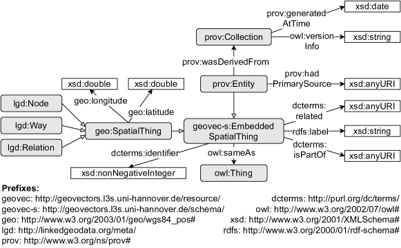
Semantic access to the GeoVectors embeddings is of utmost importance to facilitate the use of the dataset in downstream semantic applications. Therefore, GeoVectors is accompanied by a knowledge graph that models the embedding metadata. This metadata facilitates interlinking of the embeddings with established knowledge graphs such as Wikidata and DBpedia using existing entity links. This way, the GeoVectors embeddings can be used to enrich geographic entities in these knowledge graphs. The GeoVectors knowledge graph includes more than million triples and is made available under a public SPARQL endpoint777http://geovectors.l3s.uni-hannover.de/sparql.
The GeoVectors knowledge graph is based on three established vocabularies. We utilize the LinkedGeoData (Stadler et al., 2012) and the Basic Geo vocabulary888https://www.w3.org/2003/01/geo/wgs84_pos to model the spatial dimension of geographic entities, as well as the PROV Ontology (Lebo et al., 2013) for modeling data provenance, i.e., where the geographic entities were extracted from and what they represent. Figure 2 illustrates the schema of the GeoVectors knowledge graph, including its prefixes and namespaces.
Each geographic entity in the knowledge graph is typed as geovec:EmbeddedSpatialThing, which encapsulates the classes geo:SpatialThing and prov:Entity. We group the relevant properties shown in Figure 2 regarding these three classes:
-
•
geo:SpatialThing: Each geographic entity is either a node, a way or a relation and assigned to the respective LinkedGeoData class. In addition, the GeoVectors knowledge graph provides the entity’s latitude and longitude.
-
•
prov:Entity: For tracking the origins of an embedding, each geographic entity is linked to the dataset it is extracted from (prov:Collection). Through versioning of these datasets, the GeoVectors corpus and the GeoVectors knowledge graph can be extended in future versions.
-
•
geo:EmbeddedSpatialThing: The geographic entities are linked to other resources representing the same (owl:sameAs) or a related resource (dcterms:related) in Wikidata, DBpedia and Wikipedia.
Listing 1 presents the triples describing the geographic entity representing the city of Berlin. These triples provide the geolocation of Berlin, references to its counterparts in Wikidata, DBpedia, Wikipedia and OpenStreetMap, as well as provenance information (the embeddings were extracted from an OSM snapshot from November 2020). Access to the GV-Tags and GV-NLE embedding is enabled through the Zenodo DOIs 10.5281/zenodo.4321406 and 10.5281/zenodo.4957746 pointing to the GV-Tags and GV-NLE embeddings, the entity type (lgd:Node) and its identifier ().
5. GeoVectors Embedding Characteristics
In GeoVectors V1.0, we extracted representations of nodes, ways, and relations from OpenStreetMap snapshots at country-level from October 20201111footnotemark: 11. We capture all OSM entities having at least one tag. Entities without any tags typically represent geometric primitives that isolated carry no semantics. Compound OSM entities such as ways and relations typically subsume such geometric primitives and are better suited for the representation. Table 1 summarizes the number of extracted representations regarding their geographic origin. In addition, Figure 3 provides a visualization of the geographic coverage of the GeoVectors corpus. Overall, we observe high geographic coverage. In total, GeoVectors contains representations of over 980 million OpenStreetMap entities.
The most significant fraction of extracted representations is located in Europe (430 million), followed by North America (240 million) and Asia (150 million). The number of representations per region follows the distribution of available volunteered information in OpenStreetMap, most prominent in the regions mentioned above. Nevertheless, GeoVectors provides a considerable amount of entity representations for the remaining regions, e.g., 97 million entities for Africa. We believe that this amount of data is sufficient for many real-world applications. We expect that the amount of data will further increase in future OSM versions. We will include this data in future GeoVectors releases.
| Continent | No. Nodes | No. Ways | No. | |
|---|---|---|---|---|
| Relations | Total | |||
| Africa | ||||
| Antarctica | ||||
| Asia | ||||
| Australia/Oceania | ||||
| Europe | ||||
| Central-America | ||||
| North-America | ||||
| South-America | ||||
| Total |
6. Case Studies
To illustrate the utility of the GeoVectors embeddings, we have conducted two case studies dealing with the type assertion and link prediction tasks. These case studies were selected to demonstrate how widely adopted machine learning models can benefit from the GeoVectors embeddings based on semantic and geographic entity similarity. Other potential use cases include but are not limited to next trip recommendation, geographic information retrieval, or functional region discovery.
In both case studies, we use the same widely adopted classifiers: The Random Forest model is a standard random forest classifier. We use the implementation provided by the scikit-learn library999https://scikit-learn.org/ with the default parameters. The Multilayer Perceptron model is a simple feed-forward neural network. The hidden network layers have the dimensions [200, 100, 100] and use the ReLu activation function. The classification layer uses the softmax activation function. The network is trained using the Adam optimizer and a categorical cross-entropy loss. We use the default parameters from the Keras API101010https://keras.io/. As the purpose of the case studies is to demonstrate the utility of GeoVectors, rather than achieving the highest possible effectiveness of the models, we adopt the default model hyper-parameters without any further optimization.
6.1. Case Study 1: Type Assertion
The goal of this case study is to assign Wikidata classes to OSM entities, which aligns well with the established task of completing type assertions in knowledge graphs (Paulheim, 2017). We expect that this case study particularly benefits from the semantic dimension of the OSM entities as captured by the GV-Tags embeddings.
Test and training dataset generation: To obtain a set of relevant Wikidata classes, we first extract all OSM entities that possess an identity link to Wikidata. All Wikidata classes that are assigned to at least 10,000 OSM entities are selected for this case study. This way, we obtain 32 Wikidata classes, including “church building”111111https://www.wikidata.org/wiki/Q16970 and “street”121212https://www.wikidata.org/wiki/Q79007, as well as more fine-grained classes such as “village of Poland”131313https://www.wikidata.org/wiki/Q3558970. Finally, we balance the classes by applying random under-sampling and split the data into a training set (80%, 285k examples) and a test set (20%, 71k examples).
Performance: Table 2 presents the classification performance of the Random Forest and Multilayer Perceptron models using GV-Tags and GV-NLE in terms of precision, recall and F1-score.
As expected, we observe that the GV-Tags embeddings achieve a better performance than the GV-NLE embeddings concerning all metrics. In particular, GV-Tags achieves an F1-score of 85.95% and 83.43% accuracy using the Multilayer Perceptron model. The Random Forest model using GV-NLE embeddings reaches an F1-score of 50.17%. This result can be explained by a few classes such as “village of Poland” that are correlated with a location. The results of this case study confirm that the semantic proximity information is appropriately captured by the GV-Tags embeddings.
6.2. Case Study 2: Link Prediction
This case study aims to assign OSM entities to their countries of origin. This task is a typical example of link prediction, where the missing object of an RDF triple is identified (Paulheim, 2017). We expect that this case study particularly benefits from the GV-NLE embeddings based on geographic proximity.
Test and training dataset generation: To obtain a set of countries, we sample OSM entities from the country-specific snapshots141414Country-specific snapshots are available at https://download.geofabrik.de/. as described in Algorithm 1 and preserve the origin information. In analogy to case study 1, we select all countries with at least 10,000 examples and obtain 88 different countries. Again, we balance the examples by applying random under-sampling and split the data into a training set (80%, 687k examples) and a test set (20%, 171k examples).
Performance: Table 3 presents the classification performance of the Random Forest and Multilayer Perceptron models using GV-Tags and GV-NLE in terms of precision, recall, and F1-score. As expected, we observe that GV-NLE achieves a better performance than the GV-Tags embeddings concerning all metrics on this task. In particular, the GV-NLE embeddings achieve an F1-score of 96.03% and 94.80% accuracy using the Multilayer Perceptron classification model. In contrast, the GV-Tags embeddings achieve an F1-score of only 29.91% and 20.20% accuracy on this task because the OSM tags of an OSM entity are rarely related to its country of origin. The results of this case study confirm that the GV-NLE embeddings appropriately capture geographic proximity.
| GV-Tags | GV-NLE | |||||||
|---|---|---|---|---|---|---|---|---|
| Precision | Recall | F1 | Accuracy | Precision | Recall | F1 | Accuracy | |
| Random Forest | 92.80 | 69.07 | 77.37 | 69.06 | 70.97 | 41.53 | 50.17 | 41.53 |
| Multilayer Perceptron | 90.18 | 83.41 | 85.95 | 83.43 | 63.70 | 36.68 | 41.69 | 36.66 |
| GV-Tags | GV-NLE | |||||||
|---|---|---|---|---|---|---|---|---|
| Precision | Recall | F1 | Accuracy | Precision | Recall | F1 | Accuracy | |
| Random Forest | 84.38 | 20.25 | 29.91 | 20.28 | 99.08 | 89.79 | 93.67 | 89.78 |
| Multilayer Perceptron | 86.68 | 17.21 | 25.39 | 17.23 | 96.03 | 94.89 | 95.39 | 94.89 |
7. Availability & Utility
The GeoVectors website151515http://geovectors.l3s.uni-hannover.de/ provides a dataset description, the embedding framework as well as pointers to the following resources:
-
•
GeoVectors embeddings: We provide permanent access to the GeoVectors embeddings and the trained models on Zenodo under the Open Database License161616https://opendatacommons.org/licenses/odbl/. To facilitate efficient reuse, we provide embeddings in a lightweight TSV format.
-
•
The GeoVectors knowledge graph described in Section 4 can be queried through a public SPARQL endpoint that is integrated into the GeoVectors website44footnotemark: 4. In addition, we provide an interface for the label-based search of knowledge graph resources. The resources can be accessed both via HTML pages and via machine-readable formats. A machine-readable VoID description of the dataset is provided and integrated into the knowledge graph. New dataset releases will imply knowledge graph updates, where each release is accompanied by a new instance of prov:Collection.
-
•
The GeoVectors embedding generation framework presented in Section 3 is available as open-source software on GitHub22footnotemark: 2 under the MIT License.
In Section 1, we have presented the benefits of using geographic embeddings in a variety of domains (Liu et al., 2018; Xie et al., 2016; Wang and Li, 2017). With GeoVectors, we aim at providing access to easily reusable embeddings of geographic entities that can directly support tasks in these and other domains. Due to the task-independent nature of our embedding generation framework, we envision high generalizability of GeoVectors in a variety of application scenarios.
For demonstrating the effectiveness of the GeoVectors embeddings in different scenarios, we have conducted two case studies presented in Section 6, which illustrate that the GeoVectors embeddings adequately capture both the semantic and geographic similarity of OSM entities. Therefore, we believe that GeoVectors eases the use of OSM data and is of potential use for many machine learning and semantic applications that rely on geographic data. Finally, the GeoVectors framework can be reused to infer embeddings from arbitrary OSM snapshots.
For sustainability and compliance with up-to-date OSM data, we plan yearly releases of new embeddings versions.
8. Related Work
This section discusses related work in the areas of geographic embeddings, word embeddings, and knowledge graph embeddings.
Geographic Embeddings: Recently, several algorithms for the creation of domain-specific geographic embeddings emerged. Popular application domains include location recommendation (Liu et al., 2018; Xie et al., 2016), human mobility prediction (Wang and Li, 2017), and location-aware image classification (Aodha et al., 2019; Chu et al., 2019). In contrast, we provide a corpus of domain-independent embeddings extracted from OpenStreetMap without the supervision of any specific downstream task. We believe that a wide range of applications can benefit from the GeoVectors embeddings. Mai et al. proposed a location-aware knowledge graph embedding algorithm for question answering (Mai et al., 2020). However, the authors use a planar geographic projection that is only capable of capturing specific regions. In contrast, the GeoVectors corpus covers the whole globe and captures the spherical earth surface.
The neural location embeddings (NLE) (Kejriwal and Szekely, 2017) were initially proposed to encode entities included in the GeoNames knowledge base. We adopt NLE to capture the geographic dimension of OSM data. In our previous work (Tempelmeier and Demidova, 2021), we introduced an embedding algorithm for OSM that learns embeddings of individual entities. However, learning a latent representation for each entity on a world scale is not feasible. Therefore, we chose tag and location-based, effective, and efficient algorithms to infer the GeoVectors representations.
Word Embeddings: A multitude of natural language processing algorithms adopts word embedding models for downstream tasks. (Wang et al., 2020) conducted a recent survey on neural word embeddings algorithms. Recent approaches like BERT (Devlin et al., 2019), and ELMo (Peters et al., 2018) exploit the context information, e.g., the word order in sentences, to infer latent representations. In contrast, the fastText algorithm (Joulin et al., 2017) infers the latent representation of each word individually. As OSM tags describing geographic entities neither have any natural order nor form any sentences, we choose fastText over BERT and ELMo to create embeddings.
Knowledge Graph Embeddings: Knowledge graph embeddings have recently evolved as an important area to facilitate latent representations of entities and their relations (Wang et al., 2017a). General-purpose knowledge graphs like Wikidata (Vrandecic and Krötzsch, 2014), DBpedia (Auer et al., 2007), and YAGO (Tanon et al., 2020), and even specialized KGs like EventKG (Gottschalk and Demidova, 2019) and LinkedGeoData (Stadler et al., 2012) typically only include the most prominent geographic entities. Compared to OpenStreetMap, the number of geographic entities captured in such knowledge graphs is relatively low (Tempelmeier and Demidova, 2021). For instance, as of June 2021, Wikidata contained less than 8.5 million entities with geographic coordinates, while OpenStreetMap contained more than 7 billion entities. The specific geographic entities or entity types, e.g., roads or shops, might not be relevant or prominent enough to be captured by the general-purpose knowledge graphs. Nevertheless, these entities play an essential role for various downstream applications, for instance, for land use classification (Schultz et al., 2017) or in the prediction of mobility behavior (Wang et al., 2017b). Consequently, pre-trained embeddings of popular knowledge graphs, such as Wikidata (Lerer et al., 2019) or DBpedia, lack coverage of geographic entities required by spatio-temporal analytics applications. In contrast, the GeoVectors embeddings proposed in this work specifically target geographic entities and ensure adequate coverage in the resulting dataset.
9. Conclusion
In this paper, we presented GeoVectors – a linked open corpus of OpenStreetMap embeddings. GeoVectors contains embeddings of over 980 million OpenStreetMap entities in 180 countries that capture both their semantic and geographic entity similarity. GeoVectors constitutes a unique resource of geographic entities concerning its scale and its latent representations. The GeoVectors knowledge graph provides a semantic description of the corpus and includes identity links to Wikidata and DBpedia. We further provide an open-source implementation of the proposed GeoVectors embedding framework that enables the dynamic encoding of up-to-date OpenStreetMap snapshots for specific geographic regions.
Acknowledgements
This work was partially funded by DFG, German Research Foundation (“WorldKG”, 424985896), the Federal Ministry of Education and Research (BMBF), Germany (“Simple-ML”, 01IS18054), the Federal Ministry for Economic Affairs and Energy (BMWi), Germany (“d-E-mand”, 01ME19009B), and the European Commission (EU H2020, “smashHit”, grant-ID 871477).
References
- (1)
- Aodha et al. (2019) Oisin Mac Aodha, Elijah Cole, and Pietro Perona. 2019. Presence-Only Geographical Priors for Fine-Grained Image Classification. In Proc. of the ICCV 2019. IEEE, 9595–9605.
- Arsanjani et al. (2015) Jamal Jokar Arsanjani, Alexander Zipf, Peter Mooney, and Marco Helbich. 2015. An Introduction to OpenStreetMap in Geographic Information Science: Experiences, Research, and Applications. Springer, 1–15.
- Auer et al. (2007) Sören Auer, Christian Bizer, Georgi Kobilarov, Jens Lehmann, Richard Cyganiak, and Zachary G. Ives. 2007. DBpedia: A Nucleus for a Web of Open Data. In Proc. of the ISWC 2007 (LNCS, Vol. 4825). Springer, 722–735.
- Chu et al. (2019) Grace Chu, Brian Potetz, Weijun Wang, Andrew Howard, Yang Song, Fernando Brucher, Thomas Leung, and Hartwig Adam. 2019. Geo-Aware Networks for Fine-Grained Recognition. In Proc. of the ICCV Workshops 2019. IEEE, 247–254.
- Contractor et al. (2021) Danish Contractor, Shashank Goel, Mausam, and Parag Singla. 2021. Joint Spatio-Textual Reasoning for Answering Tourism Questions. In Proc. The Web Conference 2021 (WWW ’21). ACM / IW3C2, 1978–1989.
- Costa et al. (2020) Tarcísio Souza Costa, Simon Gottschalk, and Elena Demidova. 2020. Event-QA: A Dataset for Event-Centric Question Answering over Knowledge Graphs. In Proc. of the ACM CIKM 2020. ACM, 3157–3164.
- Devlin et al. (2019) Jacob Devlin, Ming-Wei Chang, Kenton Lee, and Kristina Toutanova. 2019. BERT: Pre-training of Deep Bidirectional Transformers for Language Understanding. In Proc. of the NAACL-HLT 2019. Association for Computational Linguistics, 4171–4186.
- Gao et al. (2019) Jingyue Gao, Yuanduo He, Yasha Wang, Xiting Wang, Jiangtao Wang, Guangju Peng, and Xu Chu. 2019. STAR: Spatio-Temporal Taxonomy-Aware Tag Recommendation for Citizen Complaints. In Proc. of the ACM CIKM 2019. ACM, 1903–1912.
- Gottschalk and Demidova (2019) Simon Gottschalk and Elena Demidova. 2019. EventKG - the hub of event knowledge on the web - and biographical timeline generation. Semantic Web 10, 6 (2019), 1039–1070.
- Grave et al. (2018) Edouard Grave, Piotr Bojanowski, Prakhar Gupta, Armand Joulin, and Tomás Mikolov. 2018. Learning Word Vectors for 157 Languages. In Proc. of the LREC 2018. European Language Resources Association (ELRA).
- Haklay and Weber (2008) Mordechai (Muki) Haklay and Patrick Weber. 2008. OpenStreetMap: User-Generated Street Maps. IEEE Pervasive Comput. 7, 4 (2008), 12–18.
- Homburg et al. (2020) Timo Homburg, Steffen Staab, and Daniel Janke. 2020. GeoSPARQL+: Syntax, Semantics and System for Integrated Querying of Graph, Raster and Vector Data. In Proc. of the ISWC 2020 (LNCS, Vol. 12506). Springer, 258–275.
- Huber and Rust (2016) Stephan Huber and Christoph Rust. 2016. Calculate Travel Time and Distance with OpenStreetMap Data Using the Open Source Routing Machine (OSRM). The Stata Journal (2016).
- Joulin et al. (2017) Armand Joulin, Edouard Grave, Piotr Bojanowski, and Tomás Mikolov. 2017. Bag of Tricks for Efficient Text Classification. In Proc. of the EACL 2017. Association for Computational Linguistics, 427–431.
- Kejriwal and Szekely (2017) Mayank Kejriwal and Pedro A. Szekely. 2017. Neural Embeddings for Populated Geonames Locations. In Proc. of the ISWC 2017, Part II (LNCS, Vol. 10588). Springer, 139–146.
- Keller et al. (2020) Sina Keller, Raoul Gabriel, and Johanna Guth. 2020. Machine Learning Framework for the Estimation of Average Speed in Rural Road Networks with OpenStreetMap Data. ISPRS Int. J. Geo Inf. 9, 11 (2020), 638.
- Kristiadi et al. (2019) Agustinus Kristiadi, Mohammad Asif Khan, Denis Lukovnikov, Jens Lehmann, and Asja Fischer. 2019. Incorporating Literals into Knowledge Graph Embeddings. In Proc. of The ISWC 2019 (LNCS, Vol. 11778). Springer, 347–363.
- Lebo et al. (2013) Timothy Lebo, Satya Sahoo, Deborah McGuinness, Khalid Belhajjame, James Cheney, David Corsar, Daniel Garijo, Stian Soiland-Reyes, Stephan Zednik, and Jun Zhao. 2013. PROV-O: The PROV Ontology. W3C recommendation 30 (2013).
- Lerer et al. (2019) Adam Lerer, Ledell Wu, Jiajun Shen, Timothée Lacroix, Luca Wehrstedt, Abhijit Bose, and Alex Peysakhovich. 2019. Pytorch-BigGraph: A Large Scale Graph Embedding System. In Proc. of MLSys 2019. mlsys.org.
- Liu et al. (2018) Wei Liu, Jing Wang, Arun Kumar Sangaiah, and Jian Yin. 2018. Dynamic metric embedding model for point-of-interest prediction. Future Gener. Comput. Syst. 83 (2018), 183–192.
- Mai et al. (2020) Gengchen Mai, Krzysztof Janowicz, Ling Cai, Rui Zhu, Blake Regalia, Bo Yan, Meilin Shi, and Ni Lao. 2020. SE-KGE : A location-aware Knowledge Graph Embedding model for Geographic Question Answering and Spatial Semantic Lifting. Trans. GIS 24, 3 (2020), 623–655.
- Paulheim (2017) Heiko Paulheim. 2017. Knowledge Graph Refinement: A Survey of Approaches and Evaluation Methods. Semantic Web 8, 3 (2017), 489–508.
- Perozzi et al. (2014) Bryan Perozzi, Rami Al-Rfou, and Steven Skiena. 2014. DeepWalk: Online Learning of Social Representations. In Proc. of the SIGKDD KDD 2014. ACM, 701–710.
- Peters et al. (2018) Matthew E. Peters, Mark Neumann, Mohit Iyyer, Matt Gardner, Christopher Clark, Kenton Lee, and Luke Zettlemoyer. 2018. Deep Contextualized Word Representations. In Proc. of the NAACL-HLT 2018. Association for Computational Linguistics, 2227–2237.
- Purves et al. (2018) Ross S. Purves, Paul Clough, Christopher B. Jones, Mark H. Hall, and Vanessa Murdock. 2018. Geographic Information Retrieval: Progress and Challenges in Spatial Search of Text. Found. Trends Inf. Retr. 12, 2-3 (2018), 164–318.
- Rollo and Po (2020) Federica Rollo and Laura Po. 2020. Crime Event Localization and Deduplication. In Proc. of the ISWC 2020, Part II (LNCS, Vol. 12507). Springer, 361–377.
- Schultz et al. (2017) Michael Schultz, Janek Voss, Michael Auer, Sarah Carter, and Alexander Zipf. 2017. Open land cover from OpenStreetMap and remote sensing. Int. J. Appl. Earth Obs. Geoinformation 63 (2017), 206–213.
- Scrocca et al. (2020) Mario Scrocca, Marco Comerio, Alessio Carenini, and Irene Celino. 2020. Turning Transport Data to Comply with EU Standards While Enabling a Multimodal Transport Knowledge Graph. In Proc. of The ISWC 2020, Part II (LNCS, Vol. 12507). Springer, 411–429.
- Shbita et al. (2020) Basel Shbita, Craig A. Knoblock, Weiwei Duan, Yao-Yi Chiang, Johannes H. Uhl, and Stefan Leyk. 2020. Building Linked Spatio-Temporal Data from Vectorized Historical Maps. In Proc. of The ESWC 2020 (LNCS, Vol. 12123). Springer, 409–426.
- Stadler et al. (2012) Claus Stadler, Jens Lehmann, Konrad Höffner, and Sören Auer. 2012. LinkedGeoData: A core for a web of spatial open data. Semantic Web 3, 4 (2012), 333–354.
- Tanon et al. (2020) Thomas Pellissier Tanon, Gerhard Weikum, and Fabian M. Suchanek. 2020. YAGO 4: A Reason-able Knowledge Base. In Proc. of the ESWC 2020 (LNCS, Vol. 12123). Springer, 583–596.
- Tempelmeier and Demidova (2021) Nicolas Tempelmeier and Elena Demidova. 2021. Linking OpenStreetMap with knowledge graphs - Link discovery for schema-agnostic volunteered geographic information. Future Gener. Comput. Syst. 116 (2021), 349–364.
- Touya and Reimer (2015) Guillaume Touya and Andreas Reimer. 2015. Inferring the Scale of OpenStreetMap Features. In OpenStreetMap in GIScience - Experiences, Research, and Applications. Springer, 81–99.
- Tsubouchi et al. (2020) Kota Tsubouchi, Hayato Kobayashi, and Toru Shimizu. 2020. POI Atmosphere Categorization Using Web Search Session Behavior. In Proc. of the SIGSPATIAL 2020. ACM, 630–639.
- Vargas et al. (2020) John E. Vargas, Shivangi Srivastava, Devis Tuia, and Alexandre X. Falcão. 2020. OpenStreetMap: Challenges and Opportunities in Machine Learning and Remote Sensing. IEEE Geoscience and Remote Sensing Magazine (2020).
- Vrandecic and Krötzsch (2014) Denny Vrandecic and Markus Krötzsch. 2014. Wikidata: a free collaborative knowledgebase. Commun. ACM 57, 10 (2014), 78–85.
- Wang and Li (2017) Hongjian Wang and Zhenhui Li. 2017. Region Representation Learning via Mobility Flow. In Proc. of the ACM CIKM 2017. ACM, 237–246.
- Wang et al. (2021) Meng-xiang Wang, Wang-Chien Lee, Tao-Yang Fu, and Ge Yu. 2021. On Representation Learning for Road Networks. ACM Trans. Intell. Syst. Technol. 12, 1 (2021), 11:1–11:27.
- Wang et al. (2017b) Minjie Wang, Su Yang, Yi Sun, and Jun Gao. 2017b. Human mobility prediction from region functions with taxi trajectories. PLOS ONE 12 (2017), 1–23.
- Wang et al. (2017a) Quan Wang, Zhendong Mao, Bin Wang, and Li Guo. 2017a. Knowledge Graph Embedding: A Survey of Approaches and Applications. IEEE Trans. Knowl. Data Eng. 29, 12 (2017), 2724–2743.
- Wang et al. (2020) Shirui Wang, Wen’an Zhou, and Chao Jiang. 2020. A survey of word embeddings based on deep learning. Computing 102, 3 (2020), 717–740.
- Xie et al. (2016) Min Xie, Hongzhi Yin, Hao Wang, Fanjiang Xu, Weitong Chen, and Sen Wang. 2016. Learning Graph-based POI Embedding for Location-based Recommendation. In Proc. of the ACM CIKM 2016. ACM, 15–24.