Spatio-temporal Parking Behaviour Forecasting and Analysis Before and During COVID-19
Abstract.
Parking demand forecasting and behaviour analysis have received increasing attention in recent years because of their critical role in mitigating traffic congestion and understanding travel behaviours. However, previous studies usually only consider temporal dependence but ignore the spatial correlations among parking lots for parking prediction. This is mainly due to the lack of direct physical connections or observable interactions between them. Thus, how to quantify the spatial correlation remains a significant challenge. To bridge the gap, in this study, we propose a spatial-aware parking prediction framework, which includes two steps, i.e. spatial connection graph construction and spatio-temporal forecasting. A case study in Ningbo, China is conducted using parking data of over one million records before and during COVID-19. The results show that the approach is superior on parking occupancy forecasting than baseline methods, especially for the cases with high temporal irregularity such as during COVID-19. Our work has revealed the impact of the pandemic on parking behaviour and also accentuated the importance of modelling spatial dependence in parking behaviour forecasting, which can benefit future studies on epidemiology and human travel behaviours.
1. Introduction
With the rapid increase of private cars, finding a free parking space in cities becomes increasingly challenging. This lays a heavier burden on road traffic and further contributes to congestion (Yang et al., 2019). Parking demand prediction can help adjust the parking services dynamically to improve the overall efficiency and has the potential to optimise the parking space finding process (Fiez et al., 2018). Therefore, the problem is significantly important and has attracted growing attention.
Owing to the development of information and communication technologies (ICT), we have access to more and more digital parking data, which enable us to probe into the parking behaviour from historical time-series parking records. Based on these available data, previous studies used various methods to predict parking occupancy, including support vector regressions (SVR) (Zheng et al., 2015), clustering (Tamrazian et al., 2015), time series models (Liu et al., 2010), and neural networks (Alajali et al., 2017; Yang et al., 2019). Most of the methods only focused on leveraging temporal features of the historical records, without considering the spatial connections among parking lots.
However, numerous studies have shown that passengers’ travel behaviours have significant spatial correlations (Tu et al., 2018; Gong et al., 2019). For example, studies show that passengers would take up to 500-metre walking to their final destinations (Yue et al., 2012). This suggests that residents may park their own cars in parking lots within tolerable distance of the destination, and walk to the destination after parking. The finding also implies the existence of spatial correlation between parking lots which locates near each other.
Furthermore, only considering temporal features will make the established model vulnerable to unexpected events that suffer from dramatic temporal pattern change, for example, the COVID-19, which first broke out in China and then spread globally in a short time (Organization et al., 2020). During the pandemic, compulsory restrictions were firmly implemented in China to control the respiratory infectious disease, including physical distancing and community containment measures, which significantly reduced public transport use and public gatherings (Zhou et al., 2020). These governmental policies dramatically changed the way people travel and parking. Therefore, the emergencies would pose great challenge for parking behaviour forecasting, in which case historical temporal patterns would not be sufficient.
To address these issues, in this study, unlike previous studies only considering historical time series, we proposed a spatio-temporal parking prediction framework to predict parking occupancy in the next future, accounting for both temporal and spatial correlations. The framework includes two major steps: the first step is to construct a connection graph to model the spatial connections between parking lots, the second step is spatio-temporal parking forecasting using historical time-series parking data and the generated connection graph. We performed a case study in the city of Ningbo, China, using more than one million parking records of 136 parking lots from April 2019 to April 2020 (including parking data before and during the period of COVID-19). The results demonstrate the superiority of our proposed framework in parking forecasting, especially during COVID-19 when the parking behaviours exhibited significantly temporal irregularity than normal days.
The rest of the paper is organised as follows. Section 2 reviews the related works. Section 3 presents the proposed spatial-aware parking forecasting framework. Section 4 introduces the study area and data. Section 5 presents the experimental results and analysis. Finally, Section 6 concludes the paper.
2. Literature Review
Here, we focused on reviewing the related works for parking occupancy prediction. In recent years, quite a few methods are proposed to estimate parking occupancy. These methods can be divided into two categories: first is and methods, the other is (Yang et al., 2019).
The and approaches often use historical parking data to predict short-term parking occupancy (Pullola et al., 2007). The methods include clustering (Tamrazian et al., 2015), Support Vector Regression (SVR) (Zheng et al., 2015), Autoregressive Integrated Moving Average (ARIMA) (Burns and Faurot, 1992), continuous-time Markov Chain model (Klappenecker et al., 2014), etc. With the development of technology, models of deep neural networks are gaining popularity in the area of parking modeling and prediction. Ji et al. (Ji et al., 2014) proposed a three layer wavelet neural network to predict short-term parking availability in off street garages; Vlahogianni et al. (Vlahogianni et al., 2016) approached multi-layer perceptrons (MLPs) in predicting the parking occupancy; Ziat et al. (Ziat et al., 2016) adopted a representation learning method to simultaneously predict traffic state and parking occupancy. These studies largely improved the accuracy of the prediction results compared with the statistical method. They also consider the external factors that influenced the drivers’ parking behaviours, such as parking duration, traffic congestion, weather, etc. However, most previous studies did not consider the location correlations among the parking lots, which would lack knowledge to analyse travel behaviours by private cars, and would make the prediction accuracy lower as well.
Graph convolutional neural network (GCNN) is a machine learning technology that uses the graph spectral theory to filter the signals on localised sub-graphs. The filtered signals are considered as the features for the neural networks. In recent years, GCNN has been used on spatial correlations modelling and prediction. Zhao et al. (Zhao et al., 2020) integrated GCN and GRU for short-term traffic forecasting. Yang et al. combined GCN with RNN to predict real-time on-street parking (Yang et al., 2019). Although this work consider both spatial and temporal correlations, it only consider on-street parking lots, which is directly influenced by the traffic flow. These occupancies could be much easier to predict than general parking lots. Moreover, it use real time traffic flow instead of historical data to make prediction.
Based on the background, in this study, we proposed a new spatial-temporal parking model that can capture the temporal and spatial features from the parking occupancy data, and can be used for parking services prediction based on urban design.
3. Spatio-temporal Parking Behaviour Forecasting
3.1. Problem Formulation
The problem of parking behaviour (measured by parking occupancy in our case) forecasting can be regarded as learning of the mapping function using the locations of parking lots and associated time series observations , and then predicting the parking occupancy in the next time periods, as formulated as follows:
| (1) |
where and are the lengths of the historical and forecasting time series, respectively. , in which and represent longitude and latitude, respectively.
Most previous studies (Burns and Faurot, 1992; Pullola et al., 2007) ignore the location information of parking lots and their associated spatial correlation due to the lack of direct physical connections or observable interactions between them. However, parking lots are not absolutely independent, the state of one parking lot may well impact the others, and usually the nearer ones are more likely to be influenced. The challenge is how to model the spatial correlation among them. To address this problem, we propose a spatial-aware parking prediction framework to leverage both temporal and spatial dependence.
3.2. Methodology
The proposed framework of spatio-temporal parking prediction is presented in Fig. 1. First, we build the connection graph from different locations. Then, we use a temporal graph convolution network to make spatio-temporal forecasting.
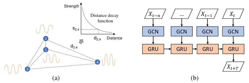
3.2.1. Connection Graph Construction:
To model the spatial dependence of the parking lots, we propose to construct a weighted graph from locations , as illustrated in Fig. 1(a), where is the node set and is the edge set. In the graph, each node denotes a parking lot and each edge represents the connection between node and . The weighted adjacency matrix can be used to indicate the topological links and the associated connection strength between the parking lots, where , with the entry values , and higher value indicates stronger connection.
As we know, it is common that people select another nearby parking lot if their targeted one has no space for parking. Therefore, the closer parking lots usually present similar parking patterns and have stronger spatial correlation. Based on this observation, unlike previous studies only considering connectivity (Zhao et al., 2020), we construct weighted adjacency matrix accounting for both connectivity and connection strength (measured by distance decay effect) to model the spatial dependence among parking lots.
Specifically, the weighted adjacency matrix can be formulated as follows:
| (2) |
where reprsents the connection strength between the -th and -th parking lots, while is the distance between them. is the distance threshold, which reflects people’s tolerance of walking distance between the parking locations and their final destinations. is the distance decay factor. When , the weighted adjacency matrix will reduce to normal binary adjacency matrix.
3.2.2. Spatio-temporal Forecasting:
We use T-GCN (Zhao et al., 2020) as our spatio-temporal forecasting model for parking prediction, which mainly consists of two components: a graph convolutional network (GCN) (Kipf and Welling, 2017) and gated recurrent units (GRU). The structure of T-GCN is presented in Fig. 1(b).
Firstly, for each time , the input feature matrix and the weighted adjacency matrix are fed into a two-layer GCN to learn new features , which have incorporated into spatial dependence from the locations of parking lots:
| (3) |
where , , ; and are the weight matrices of the first and second layer, while and are the activation functions. Then, the new feature matrix series will be fed into GRU repeatedly to learn the temporal features. The updating process can be formulated as follows:
| (4) |
where and are the update and reset gates at time , is the cell state and denotes the output at time . and represent weights and biases.
In the training process, the goal is to minimise the error between the real parking occupancy and the predicted one. Back-propagation algorithm is used to update the parameters of the model. After training, T-GCN can model both the spatial and temporal dependence and learn to predict future parking occupancy. Then, the trained model can be used for parking forecasting.
4. Study Area and Data
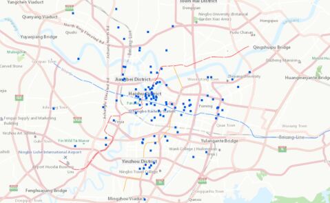
We take Ningbo, China as our study area, which is a major port and industrial hub in the east of China and lies south of Shanghai, with a population of 7.6 million. One-month parking data in 136 parking lots are used before and during COVID-19. The spatial distribution of the parking lots are shown in Fig. 2. As can be seen, the 136 parking lots occupy most of the areas in Ningbo. Concretely, we collect one-week parking data in November 2019 (including 5 working days and 2 non-working days), and 17 days parking data during COVID-19 (including 11 working days and 6 non-working days from February 2020 to April 2020). The data include information of parking lots, such as name, location (longitude and latitude), open time, recording time, and parking occupancy. To guarantee the data quality, we clean the data with two preprocessing steps: (i) for each parking lot, we only retain data once per hour by calculating average occupancy per hour; (ii) we only retain data of 12 hours, from 8 am to 8 pm before COVID-19, and 8 am to 6 pm during COVID-19 due to the data limitation.
4.1. Spatio-temporal Parking Patterns
We analyse the spatio-temporal parking patterns in Ningbo before and during COVID-19 by aggregating the parking volumes from the perspective of time and space, respectively. The results are shown in Fig. 3.
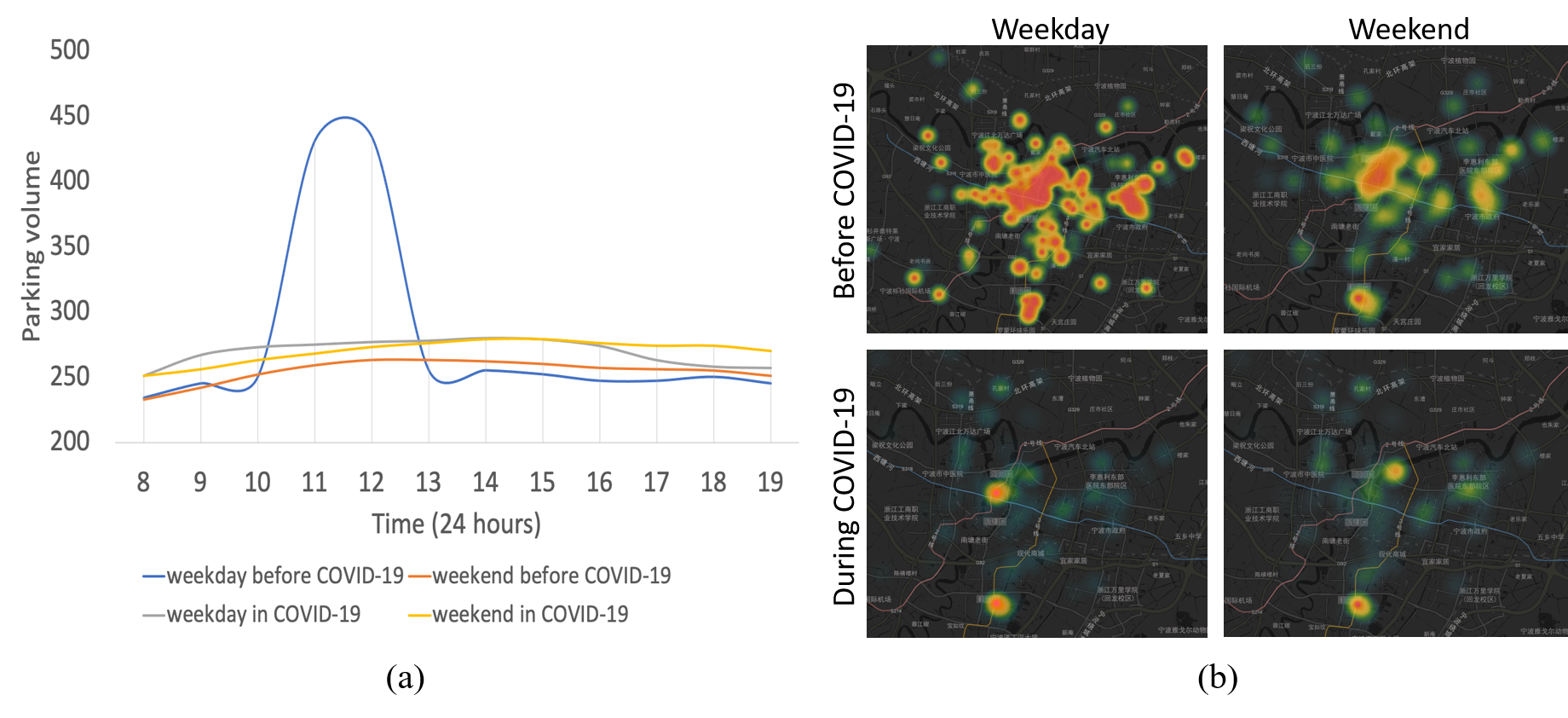
As can be seen in Fig. 3(a), We find that the parking volume in weekdays before COVID-19 has a distinct peak from around 11 am to 12 pm, which is quite unusual compared with other times. This suggests that most people prefer to park their private cars in the parking lots at noon, instead of driving them on the road. The finding is interesting but not surprising, since in most urban cities in China, there often tends to be less traffic at noon. In other times, the parking occupancy volume are relatively stable. The temporal patterns show that the parking behaviours have changed drastically during the COVID-19 period, which also implies that the normal commuting life has been deeply affected by the unexpected event.
Fig. 3(b) shows the heatmap of passengers’ parking distribution at 8 am of weekday and weekend before and during COVID-19. We can see that: (i) Comparing the parking occupancy distribution before (upper row of Fig. 3(b)) and during COVID-19 (bottom row of Fig. 3(b)), we see that passengers’ driving behaviours are much more active and diverse before COVID-19. More specifically, before COVID-19, parking lots in business buildings, schools, and entertainment areas have very high parking occupancy volume in weekdays. While on weekends, private cars are mostly located in city centres, around Tianyi Square for shopping, and the Old Bund for entertainment. (ii) From the bottom row of Fig. 3(b), we see that passengers have very similar parking behaviours in different times during COVID-19. Most passengers’ cars are parked in residential areas in weekday and weekend. In particular, Ronganfu residential community, and Tuyuan residential community in weekday (two hotspots in the bottom-left of Fig. 3(b)), and Ziyutai residential community, and Ronganfu residential community in weekend (two hotspots in the bottom-right of Fig. 3(b)).
5. Experiments and Analysis
5.1. Experiment Setup
To verify our method, we split each dataset (before and during COVID-19) into two subsets. Specifically, we take first 80% of the data for training, and the rest 20% are used to evaluate the results.
To construct the weighted adjacency matrix, we use grid search to find the best decay factor within , which is empirically set to be 1.25. The distance threshold is set to 500 metres (Euclidean distance) in our experiments since previous studies indicate that people would take up to 500-metre walking to their final destination (Yue et al., 2012). We have also compared different thresholds to examine the impact of distance thresholds in the following experiments.
To train our framework, we empirically adjust and set the learning rate to 0.001, the batch size to 64, and the training epoch to 3000. Besides, we also approached four other baseline methods (ARIMA, ANN, SVR, and GRU) for comparisons. Three criteria (RMSE, MAE, MAPE) are used as evaluation metrics. For each criterion, larger value indicates greater error, and vice versa.
| Metric | Weekday | Weekend | ||||||||
|---|---|---|---|---|---|---|---|---|---|---|
| ARIMA | SVR | ANN | GRU | Ours | ARIMA | SVR | ANN | GRU | Ours | |
| RMSE | 0.12 | 0.11 | 0.10 | 0.07 | 0.07 | 0.08 | 0.08 | 0.07 | 0.06 | 0.06 |
| MAE | 0.11 | 0.10 | 0.08 | 0.05 | 0.05 | 0.07 | 0.07 | 0.07 | 0.07 | 0.06 |
| MAPE | 21.50 | 24.52 | 30.55 | 11.12 | 10.74 | 18.52 | 19.23 | 23.46 | 12.77 | 12.62 |
| Metric | Weekday | Weekend | ||||||||
|---|---|---|---|---|---|---|---|---|---|---|
| ARIMA | SVR | ANN | GRU | Ours | ARIMA | SVR | ANN | GRU | Ours | |
| RMSE | 0.10 | 0.25 | 0.10 | 0.13 | 0.09 | 0.89 | 0.62 | 0.60 | 0.29 | 0.28 |
| MAE | 0.08 | 0.06 | 0.09 | 0.11 | 0.06 | 0.89 | 0.73 | 0.59 | 0.14 | 0.11 |
| MAPE | 36.66 | 47.90 | 29.14 | 13.10 | 11.82 | 47.90 | 25.89 | 36.00 | 13.38 | 12.22 |
5.2. Parking Forecasting Results
The overall parking occupancy prediction results using data from before and during COVID-19 are shown in Table 1 and Table 2, respectively. We can see: (i) Our framework achieves the best results with the lowest errors compared with other methods in all the time periods (before and during COVID-19). In particular, our framework has higher prediction accuracy than GRU, which demonstrates the effectiveness of modelling spatial dependence among parking lots and further implies that parking behaviours in nearer parking lots have stronger spatial correlations since . (ii) In general, the parking prediction errors during COVID-19 is higher than that of normal days for both GRU and our framework (e.g. RMSE is 0.09 and 0.28 during the pandemic compared with 0.07 and 0.06 before COVID-19 for our framework). This implies that the parking behaviours are much more irregular during COVID-19 and it is harder for the models to make right predictions. (iii) Our framework improves the prediction performance (over GRU) more significantly during COVID-19, with RMSE decrease of 0.04 and 0.01 during COVID-19 and limited improvement before COVID-19. This suggests that the modelling of spatial dependence contributes more with cases of higher time irregularity.
| Time | Metric | Weekday | Weekend | ||||
|---|---|---|---|---|---|---|---|
| 500 m | 1 km | Infinity | 500 m | 1 km | Infinity | ||
| Before COVID-19 | RMSE | 0.07 | 0.41 | 3.18 | 0.06 | 0.16 | 2.63 |
| MAE | 0.05 | 0.40 | 3.13 | 0.06 | 0.15 | 2.62 | |
| MAPE | 10.74 | 29.18 | 682.50 | 12.62 | 22.37 | 422.57 | |
| During COVID-19 | RMSE | 0.09 | 0.11 | 4.50 | 0.28 | 0.43 | 1.18 |
| MAE | 0.06 | 0.08 | 4.50 | 0.11 | 0.25 | 1.10 | |
| MAPE | 11.82 | 19.73 | 677.60 | 12.22 | 39.30 | 196.64 | |
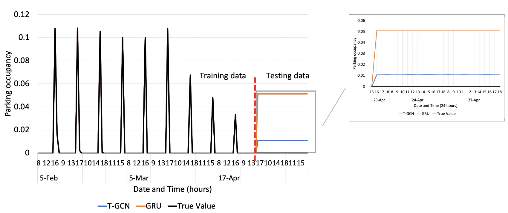
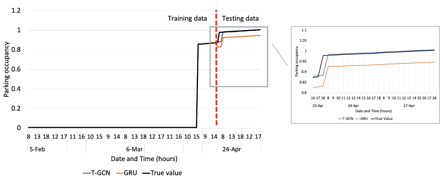
To go deeper, we select two typical parking lots (i.e. Shipu restaurant and Shanjing shopping centre) to investigate into the performance of our framework and baseline GRU during COVID-19. In particular, this two typical parking lots are highly influenced by COVID-19 and have poor time regularities during this time period. The forecasting results are presented in Fig. 4. From the results, we can see that our framework has much better performance than GRU on predicting future parking occupancy during COVID-19. This further reinforce our findings that the incorporation of spatial dependence can help when there is less temporal regularity. We therefore argue the importance of modelling spatial correlations for more accurate and robust parking occupancy prediction, especially during emergencies.
5.3. Impact of Distance Threshold
To evaluate the impact of distance threshold on forecasting accuracy, we compare the results of using different threshold settings, i.e. 500 m, 1 km, and infinity (full connection). The results are presented in Table 3. As can be seen, the threshold of 500 m has the best performance for all the cases. The results imply that parking lots locating within 500 m have strong spatial correlations. This finding is consistent with previous studies in that passengers normally would prefer to walk up to 500 m (Gong et al., 2017; Yue et al., 2012).
5.4. Parking-related Activities Analysis
To further investigate the reason why citizens’ parking behaviours exhibit higher temporal irregularity, we extract passengers’ social activity-related parking patterns between normal days and COVID-19 period. Firstly, we annotate the related activity of each parking lot via Gaode Map (a Chinese online mapping service like Google Maps). Then, for each type of activity, we calculate the average occupancy of all related parking lots in the certain time period. The results are shown in Fig. 5.
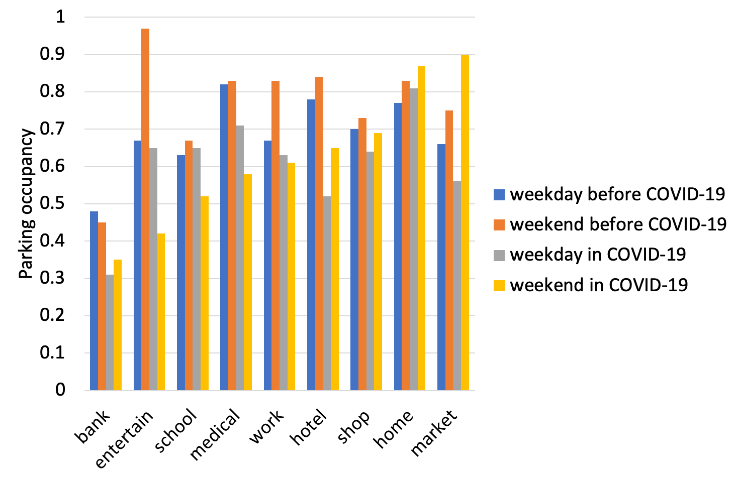
From the results, we can see that: (i) In general, parking occupancy during COVID-19 is lower than normal days, especially for work, hotel, and shopping-related activities. This suggests that people reduce their time for unnecessary activities to avoid infection. One interpretation is, some citizens choose to work at home, and reduce the number of shopping time; (ii) in weekdays, people would spent much more time to bank (48% parking occupancy), medical institutions (82%), taking a trip in different city (hotel-related activity, 78%), or go to market in normal days than in COVID-19. (iii) in weekends, citizens would spent less time especially for entertainment, school, and medical related activities during COVID-19. However, during COVID-19, market-related activities were much higher than normal (90%). This is reasonable and suggests that, during COVID-19, people would spend as much time as they could staying at home to avoid infection, and they would prefer to buy sufficient daily necessities at weekends. (iv) In addition, we find that parking lots which locate near the banks always have lower occupancy compared with other activities. This may be due to several reasons: first, banks reserve some parking space for the safety of cash truck; second, some banks would reserve parking space for their customers, and other cars are not welcomed.
6. Conclusion
In this paper, we have proposed a spatial-aware parking prediction framework leveraging both spatial and temporal correlations among parking lots. A case study in Ningbo, China has been conducted to evaluate the proposed method. Results demonstrate that the framework has higher predictive power than other baseline methods, especially for the case with less time regularities (such as during COVID-19). Our study therefore highlights the importance of spatial correlation, in addition to temporal dependence, in forecasting parking behaviours, particular in unexpected situations with irregular time patterns. Though proposed for parking prediction, our method can also be applied to make spatio-temporal forecasting of other location-related variables such as temperature and air quality from temporal observations of monitoring stations.
In addition, we have also discovered spatio-temporal patterns of parking behaviour before and during COVID-19 in Ningbo, using parking data containing approximately one million parking records over half year time span. The results show that personal cars are used much less during COVID-19 than before, especially for unnecessary activities like entertainment and long-distance travelling. Besides, most of the cars are parked in the residential areas during the pandemic, while passengers prefer to park their car in workplaces and residential areas in weekdays and city centres for entertainment in weekends before COVID-19.
In future, we would like to perform the following extensions: (i) link the parking data with more data sources to enhance the parking behaviour forecasting and analysis, (ii) further improve the forecasting method by improving the integration of the connection graph and spatio-temporal forecasting model.
7. Acknowledgments
This work is supported by the Fundamental Research Funds for the Central Universities (Grant No.590121033), National Natural Science Foundation of China (Grant No.72071116), Natural Science Foundation of Zhejiang Province (Grant No. LR17G010001) and Ningbo Municipal Bureau of Science and Technology (Grant No. 2019B10026 & 2017D10034).
References
- (1)
- Alajali et al. (2017) Walaa Alajali, Sheng Wen, and Wanlei Zhou. 2017. On-street car parking prediction in smart city: a multi-source data analysis in sensor-cloud environment. In International Conference on Security, Privacy and Anonymity in Computation, Communication and Storage. Springer, 641–652.
- Burns and Faurot (1992) Malcolm R Burns and David J Faurot. 1992. An econometric forecasting model of revenues from urban parking facilities. Journal of Economics and Business 44, 2 (1992), 143–150.
- Fiez et al. (2018) Tanner Fiez, Lillian J Ratliff, Chase Dowling, and Baosen Zhang. 2018. Data driven spatio-temporal modeling of parking demand. In 2018 Annual American Control Conference (ACC). IEEE, 2757–2762.
- Gong et al. (2019) Shuhui Gong, John Cartlidge, Ruibin Bai, Yang Yue, Qingquan Li, and Guoping Qiu. 2019. Extracting activity patterns from taxi trajectory data: a two-layer framework using spatio-temporal clustering, Bayesian probability and Monte Carlo simulation. International Journal of Geographical Information Science (2019), 1–25.
- Gong et al. (2017) Shuhui Gong, John Cartlidge, Yang Yue, Guoping Qiu, Qingquan Li, and Jingyu Xin. 2017. Geographical huff model calibration using taxi trajectory data. In Proceedings of the 10th ACM SIGSPATIAL Workshop on Computational Transportation Science. ACM, 30–35.
- Ji et al. (2014) Yanjie Ji, Dounan Tang, Phil Blythe, Weihong Guo, and Wei Wang. 2014. Short-term forecasting of available parking space using wavelet neural network model. IET Intelligent Transport Systems 9, 2 (2014), 202–209.
- Kipf and Welling (2017) Thomas N. Kipf and Max Welling. 2017. Semi-Supervised Classification with Graph Convolutional Networks. In 5th International Conference on Learning Representations, ICLR 2017, Toulon, France, April 24-26, 2017, Conference Track Proceedings.
- Klappenecker et al. (2014) Andreas Klappenecker, Hyunyoung Lee, and Jennifer L Welch. 2014. Finding available parking spaces made easy. Ad Hoc Networks 12 (2014), 243–249.
- Liu et al. (2010) Shixu Liu, Hongzhi Guan, Hai Yan, and Huanhuan Yin. 2010. Unoccupied parking space prediction of chaotic time series. In ICCTP 2010: Integrated Transportation Systems: Green, Intelligent, Reliable. 2122–2131.
- Organization et al. (2020) World Health Organization et al. 2020. Coronavirus disease 2019 (COVID-19): situation report, 54. (2020).
- Pullola et al. (2007) Sherisha Pullola, Pradeep K Atrey, and Abdulmotaleb El Saddik. 2007. Towards an intelligent GPS-based vehicle navigation system for finding street parking lots. In 2007 IEEE International Conference on Signal Processing and Communications. IEEE, 1251–1254.
- Tamrazian et al. (2015) Arbi Tamrazian, Zhen Qian, and Ram Rajagopal. 2015. Where is my parking spot? online and offline prediction of time-varying parking occupancy. Transportation Research Record 2489, 1 (2015), 77–85.
- Tu et al. (2018) Wei Tu, Rui Cao, Yang Yue, Baoding Zhou, Qiuping Li, and Qingquan Li. 2018. Spatial variations in urban public ridership derived from GPS trajectories and smart card data. Journal of Transport Geography 69 (2018), 45–57.
- Vlahogianni et al. (2016) Eleni I Vlahogianni, Konstantinos Kepaptsoglou, Vassileios Tsetsos, and Matthew G Karlaftis. 2016. A real-time parking prediction system for smart cities. Journal of Intelligent Transportation Systems 20, 2 (2016), 192–204.
- Yang et al. (2019) Shuguan Yang, Wei Ma, Xidong Pi, and Sean Qian. 2019. A deep learning approach to real-time parking occupancy prediction in transportation networks incorporating multiple spatio-temporal data sources. Transportation Research Part C: Emerging Technologies 107 (2019), 248–265.
- Yue et al. (2012) Yang Yue, Han-dong Wang, Bo Hu, Qing-quan Li, Yu-guang Li, and Anthony GO Yeh. 2012. Exploratory calibration of a spatial interaction model using taxi GPS trajectories. Computers, Environment and Urban Systems 36, 2 (2012), 140–153.
- Zhao et al. (2020) L. Zhao, Y. Song, C. Zhang, Y. Liu, P. Wang, T. Lin, M. Deng, and H. Li. 2020. T-GCN: A Temporal Graph Convolutional Network for Traffic Prediction. IEEE Transactions on Intelligent Transportation Systems 21, 9 (2020), 3848–3858.
- Zheng et al. (2015) Yanxu Zheng, Sutharshan Rajasegarar, and Christopher Leckie. 2015. Parking availability prediction for sensor-enabled car parks in smart cities. In 2015 IEEE Tenth International Conference on Intelligent Sensors, Sensor Networks and Information Processing (ISSNIP). IEEE, 1–6.
- Zhou et al. (2020) Ying Zhou, Renzhe Xu, Dongsheng Hu, Yang Yue, Qingquan Li, and Jizhe Xia. 2020. Effects of human mobility restrictions on the spread of COVID-19 in Shenzhen, China: a modelling study using mobile phone data. The Lancet Digital Health 2, 8 (2020), e417–e424.
- Ziat et al. (2016) Ali Ziat, Bertrand Leroy, Nicolas Baskiotis, and Ludovic Denoyer. 2016. Joint prediction of road-traffic and parking occupancy over a city with representation learning. In 2016 IEEE 19th International Conference on Intelligent Transportation Systems (ITSC). IEEE, 725–730.