Using transfer learning to study burned area dynamics: A case study of refugee settlements in West Nile, Northern Uganda
Abstract.
With the global refugee crisis at a historic high, there is a growing need to assess the impact of refugee settlements on their hosting countries and surrounding environments. Because fires are an important land management practice in smallholder agriculture in sub-Saharan Africa, burned area (BA) mappings can help provide information about the impacts of land management practices on local environments. However, a lack of BA ground-truth data in much of sub-Saharan Africa limits the use of highly scalable deep learning (DL) techniques for such BA mappings. In this work, we propose a scalable transfer learning approach to study BA dynamics in areas with little to no ground-truth data such as the West Nile region in Northern Uganda. We train a deep learning model on BA ground-truth data in Portugal and propose the application of that model on refugee-hosting districts in West Nile between 2015 and 2020. By comparing the district-level BA dynamic with the wider West Nile region, we aim to add understanding of the land management impacts of refugee settlements on their surrounding environments.
1. Introduction
The global refugee crisis is at a historic high with a staggering 26 million refugees and 79.5 million forcibly displaced people globally, as of end-2019 (for Refugees, 2020a). Uganda hosts the largest refugee population in Africa and the fourth largest in the world. The country has a long history of hosting refugees dating back to the late 1950s and has experienced continuous flows of refugees from Rwanda, Burundi, Ethiopia, the Democratic Republic of the Congo, and South Sudan that are fleeing from persisting violence in their home countries (Mulumba and Namuggala, 2014). Many new refugee settlements have been established in the West Nile region of Northern Uganda, following renewed conflict particularly in South Sudan since 2013 (Ahimbisibwe, 2019). Although refugee movements and impacts on hosting countries have been studied for a long time, there is little understanding of how refugee settlements impact the local environment they are forcibly displaced to and the long-term consequences of this (Nakalembe et al., 2021; Van Den Hoek, 2017). In this regard, the Global Compact on Refugees (GCR) was established to ease the burden of those refugee settlements on hosting countries while emphasizing the importance of better insights into the refugee-environment nexus (Maystadt et al., 2020).
While there is already a lack of understanding of the refugee-environment nexus globally, this is further complicated by the changing dynamics of local environmental conditions through climate change. Generally, refugee settlements are found to be especially vulnerable to climate change impacts through systematic geographic isolation in environmentally vulnerable locations. Furthermore, restrictive local asylum policies are found to reinforce disenfranchisement of refugees and often limit their abilities to cope with changing environmental conditions (Van Den Hoek et al., 2021; Blair et al., 2020). This vulnerability to climate change makes the need to understand refugee-environment relationships even more pressing. In this context, understanding the dynamics between refugee settlement establishments and land management practices such as the use of fire can add further insights into the environmental impacts of refugee settlements. While these insights are required for better planning and management as well as ensuring the sustainability of host and refugee relationships, they could provide an interesting perspective on potential reinforcing cycles of specific climate change vulnerability of refugee settlements and further environmental degradation of their hosting regions.
BA maps represent the spatial extent of an area that experienced fire between two distinct points in time (Giglio et al., 2018). While fires have a historic, often positive, role to play in the long-term health of ecosystems (Food and Agriculture Organization of the United Nations, 2007), they can significantly impact the local environment and negatively influence local climate resilience through post-fire effects such as soil erosion, interruptions of hydrological regimes, changing vegetation compositions and in extreme circumstances loss of life and destruction of property (Szpakowski and Jensen, 2019).
2. Related Work
The advancements of remote sensing data and analysis methods for BA mapping have transformed global research and policy-making communities’ capabilities to assess global and local fire dynamics, trends and outbreaks in a near-real-time manner (Szpakowski and Jensen, 2019). For example, the MODIS-based MCD64A1 collection 6 model is providing global and daily BA assessments for researchers, policy-makers, and fire managers (Giglio et al., 2018). However, the 500m spatial resolution of this model leads to a high detection threshold for BA and thus, small BAs are often omitted in the product(Roteta et al., 2019). Since smallholder agricultural practices (e.g., slash and burn) are the predominant driver of fires and BA in Uganda and much of Sub-Saharan Africa, the high detection threshold of MODIS-based BA models leads to the omission of up to 70% of total BA in Sub-Saharan Africa (Nakalembe et al., 2021; Zubkova et al., 2019; Roteta et al., 2019). Possibly due to these high omission rates and the complexity of fire practices, a recent study of refugee-environmental relationships found no statistical evidence for an increase in the MODIS-based BA Index MCD43A4 in the surroundings of refugee settlements in 49 African countries (Maystadt et al., 2020).
With limited abilities to capture fire dynamics in the surroundings of refugee settlements in Northern Uganda with current state-of-the-art BA models, there is a need to develop automated and scalable BA models with higher spatial resolution and lower BA detection thresholds for these areas (Roteta et al., 2019). While recent advances in the use of supervised deep learning (DL) models have brought significant improvements to BA detection thresholds and provide a growing knowledge base for building efficient and scalable BA models with higher spatial resolution data (e.g. Sentinel-2 remote sensing data) (Pinto et al., 2020; Knopp et al., 2020), the lack of BA ground-truth data in Sub-Saharan Africa remains a limiting factor for using those supervised DL methods in these critical regions.
3. Proposed Methodology and Preliminary Results
To overcome the discussed challenges with existing BA models, we propose to train a DL BA model on a region with ample ground-truth data and subsequently apply that model to a region with little to no ground-truth data through transfer learning. With the high availability and quality of BA ground-truth data in Portugal and a local presence of semi-arid climatic conditions and vegetation cover, we propose to train a DL framework on Portuguese BA data and 20m spatial resolution Sentinel-2 remote sensing data from 2016 (fire-record year in Portugal) and then apply this model to a range of refugee-hosting districts in the West Nile region in Northern Uganda from 2015-2020. See Table 1 for a proposed list of refugee settlements, districts, refugee populations and settlement establishment dates. By obtaining high-resolution BA mappings in those districts we aim to analyze how the establishment of refugee settlements possibly influenced the local fire dynamics.
| Settlement | District | Total refugees | Established |
|---|---|---|---|
| Rhino Camp | Arua | 116,374 | 1980 |
| Imvempi | Arua | 64,486 | 02/2017 |
| Bidi Bidi | Yumbe | 231,395 | 08/2016 |
| Lobule | Koboke | 5,393 | 09/2013 |
| Palorinya | Moyo | 122,238 | 12/2016 |
| Adjumani | Adjumani | 212,710 | 2014-2018 |
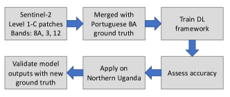
Our approach consists of six key steps, also outlined in Figure 1:
-
(1)
Merge the Near-Infrared (8A), Green (3) and Shortwave-Infrared (12) bands, often used to highlight BA (Riebeek, 2014), from the Sentinel-2 Level-1C data product for Portugal (2016) and the selected West Nile districts (2015-2020).
-
(2)
Extract -pixel patches from the merged false-color images and stack the patches with the Portuguese BA ground-truth labels (available at: (Instituto da Conservação da Natureza e das Florestas (ICNF), 2017)).
-
(3)
Train the DL model on the Portuguese ground-truth data.
-
(4)
Assess the accuracy of the model outputs with Intersection-over-Union (IoU) and Dice scores.
-
(5)
Apply the model for inference on the selected West Nile districts and the West Nile region as a whole (as control).
-
(6)
Evaluate the model outputs with a hand-labeled validation dataset from Northern Uganda using IoU and Dice metrics.
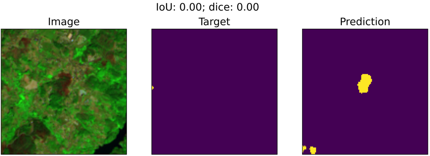
While the proposed steps are work in progress, steps 1 to 4 have been already conducted and step 5 is in experiment. After merging the bands to raster images, we extracted patches that overlapped with BA ground-truth within a 90-day timeframe and thus collected a total of 2,704 128x128 false-color images that were split into 70% training/validation and 30% test images. We used a U-Net (Ronneberger et al., 2015) architecture that includes convolutional layers in an encoder and decoder network. We used ResNet-18, an 18-layer residual neural network for the encoder and a decoding PSPNet (Zhao et al., 2017) for the decoder. We used a batch size of 16 for training. The model output is a pixel-level semantic segmentation map with two classes: burned and not burned.
The accuracy of the predicted segmentation maps was assessed with IoU and Dice scores. We obtained averaged IoU of and Dice score of on the test dataset, as presented in Figure 2.
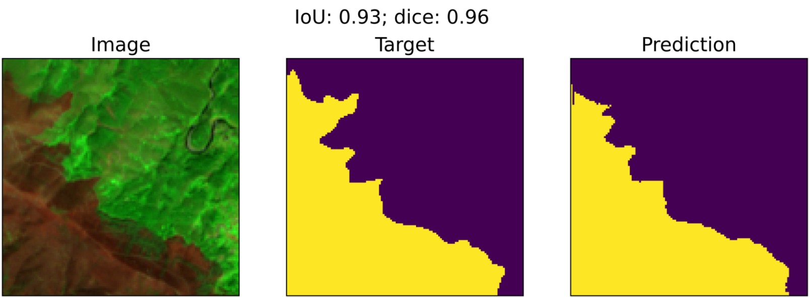
While the BA model showed good performance for most of the Portuguese scenes, we observed several inaccuracies in the ground-truth data that resulted in lower IoU and Dice scores for some samples. Figure 3 shows an example input for which the model correctly predicted the presence of burned area that was not captured in the ground-truth label. This suggests that there might be other label errors in the training set that the model was able to overcome during training. To more accurately assess test performance in future work, we will visually validate test samples to remove samples with potential label errors.
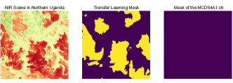
First experimental transfer applications of the trained BA model on Northern Uganda showed a large amount of additionally detected BAs when compared with the MCD64A1 output for the same scene (see figure 4. While a validation with actual ground-truth will be crucial to determine whether detected BA artifacts in the Uganda scene correspond to actual BA, we can already detect a significant difference between our model and the MCD64A1 BA output (which essentially did not detect any BA in the present scene). With a large-scale application of the transfer learning approach to the proposed districts and regions, we will further be able to investigate the challenges that might arise from the significant domain shift between Portugal and Northern Ugandan vegetation. Further biases and accuracy limitations might also be induced by using the atmospherically uncorrected Sentinel-2 Level 1C data product that was used due to the lack of an atmospherically corrected Sentinel-2 product (Level 2) for the year 2016 on the Sentinel HUB.
To ensure reproducibility of the conducted steps and promote future research on BA mapping, we also include our GitHub repository (https://github.com/prhuppertz/Burned_Area_Detection), that includes all processing, training, testing and assessment code with specific reproduction guidance and notes on parameter choices, such as hyperparameters of the DL model.
4. Overall Vision
The goal of this work is to help better estimate the impact of refugee settlement establishments on local fire dynamics and thus deliver new insights on the complex refugee-environment relationships. While the focus of our study is the West Nile region in Northern Uganda, we hope this approach can be applied and further developed by other researchers to study the refugee-BA relationships in other regions, as well. Furthermore, this work will assess the potential to create globally scalable BA models using a DL model trained with data from a region with ample ground-truth data to directly infer BA in an area with little to no ground-truth data.
Acknowledgements.
Authors thank Jevgenij Gamper and the Cervest team for the significant help in building and documenting the data processing and DL training pipeline used and published in this paper.References
- (1)
- Ahimbisibwe (2019) Frank Ahimbisibwe. 2019. Uganda and the refugee problem: challenges and opportunities. African Journal of Political Science and International Relations 13, 5 (2019), 62–72. https://doi.org/10.5897/AJPSIR2018.1101
- Blair et al. (2020) Christopher Blair, Guy Grossman, and Jeremy M. Weinstein. 2020. Forced Displacement and Asylum Policy in the Developing World. SSRN (2020). https://doi.org/10.2139/ssrn.3565557
- Food and Agriculture Organization of the United Nations (2007) Food and Agriculture Organization of the United Nations. 2007. Fire Management Assessment Report - Part 1. http://www.fao.org/3/a0969e/a0969e00.htm
- for Refugees (2020a) United Nations High Commissioner for Refugees. 2020a. Figures at a Glance. Technical Report. UNHCR. https://www.unhcr.org/figures-at-a-glance.html
- for Refugees (2020b) United Nations High Commissioner for Refugees. 2020b. Uganda Fact Sheet. Technical Report. UNHCR. https://reporting.unhcr.org/sites/default/files/UNHCRUgandaFactSheet-January2020{_}0.pdf
- Giglio et al. (2018) Louis Giglio, Luigi Boschetti, David P. Roy, Michael L. Humber, and Christopher O. Justice. 2018. The Collection 6 MODIS burned area mapping algorithm and product. Remote Sensing of Environment 217, March (2018), 72–85. https://doi.org/10.1016/j.rse.2018.08.005
- Instituto da Conservação da Natureza e das Florestas (ICNF) (2017) Instituto da Conservação da Natureza e das Florestas (ICNF). 2017. Areas Ardidas 2016. http://www2.icnf.pt/portal/florestas/dfci/inc/mapas
- Knopp et al. (2020) Lisa Knopp, Marc Wieland, Michael Rättich, and Sandro Martinis. 2020. A Deep Learning Approach for Burned Area Segmentation with Sentinel-2 Data. Remote Sensing 12, 7 (2020). https://doi.org/10.3390/rs12152422
- Maystadt et al. (2020) Jean François Maystadt, Valerie Mueller, Jamon Van Den Hoek, and Stijn Van Weezel. 2020. Vegetation changes attributable to refugees in Africa coincide with agricultural deforestation. Environmental Research Letters 15, 4 (2020). https://doi.org/10.1088/1748-9326/ab6d7c
- Mulumba and Namuggala (2014) Deborah Mulumba and Victoria Flavia Namuggala. 2014. War Experiences and Gendered Responses to Post Conflict Reintegration: The Case of Lira District in Northern Uganda. https://doi.org/10.1007/978-3-319-06001-9_3
- Nakalembe et al. (2021) Catherine Nakalembe, Maria Zubkova, Joanne Vanessa Hall, Fernanda Argueta, and Louis Giglio. 2021. LCLUC and Fire in Bidi Bidi Refugee Settlement, Uganda [unpublished article]. (2021).
- Pinto et al. (2020) Miguel M. Pinto, Renata Libonati, Ricardo M. Trigo, Isabel F. Trigo, and Carlos C. DaCamara. 2020. A deep learning approach for mapping and dating burned areas using temporal sequences of satellite images. ISPRS Journal of Photogrammetry and Remote Sensing 160, January (2020), 260–274. https://doi.org/10.1016/j.isprsjprs.2019.12.014
- Riebeek (2014) Holli Riebeek. 2014. Why is that Forest Red and that Cloud Blue? How to Interpret a False-Color Satellite Image. https://earthobservatory.nasa.gov/features/FalseColor
- Ronneberger et al. (2015) Olaf Ronneberger, Philipp Fischer, and Thomas Brox. 2015. U-Net: Convolutional Networks for Biomedical Image Segmentation. In Lecture Notes in Computer Science. Springer International Publishing, 234–241.
- Roteta et al. (2019) E. Roteta, A. Bastarrika, M. Padilla, T. Storm, and E. Chuvieco. 2019. Development of a Sentinel-2 burned area algorithm: Generation of a small fire database for sub-Saharan Africa. Remote Sensing of Environment 222, December (2019), 1–17. https://doi.org/10.1016/j.rse.2018.12.011
- Szpakowski and Jensen (2019) David M. Szpakowski and Jennifer L.R. Jensen. 2019. A review of the applications of remote sensing in fire ecology. Remote Sensing 11, 22 (2019). https://doi.org/10.3390/rs11222638
- Van Den Hoek (2017) Jamon Van Den Hoek. 2017. Assessing enviro-climatic marginality at 922 refugee camps using Earth Engine. (2017). https://www.conflict-ecology.org/speaking#h.p_gAQRJj4Vm-Zv
- Van Den Hoek et al. (2021) Jamon Van Den Hoek, David Wrathall, and Hannah Friedrich. 2021. A Primer on Refugee-Environment Relationships. PERN Cyberseminar on Refugee and internally displaced populations, environmental impacts and climate risks (2021). https://www.populationenvironmentresearch.org/pern_files/papers/VanDenHoek_et_al_Refugee_Environment_Primer_0.pdf
- Zhao et al. (2017) Hengshuang Zhao, Jianping Shi, Xiaojuan Qi, Xiaogang Wang, and Jiaya Jia. 2017. Pyramid scene parsing network. In Proceedings - 30th IEEE Conference on Computer Vision and Pattern Recognition, CVPR 2017. 6230–6239. https://doi.org/10.1109/CVPR.2017.660
- Zubkova et al. (2019) Maria Zubkova, Luigi Boschetti, John T. Abatzoglou, and Louis Giglio. 2019. Changes in Fire Activity in Africa from 2002 to 2016 and Their Potential Drivers. Geophysical Research Letters (2019). https://doi.org/10.1029/2019GL083469