Wavelet Analysis of Dengue Incidence and its Correlation with Weather and Vegetation Variables in Costa Rica
Abstract
Dengue represents a serious public health problem in tropical and subtropical regions worldwide. The number of dengue cases and its geographical expansion has increased in recent decades, driven mostly after by social and environmental factors. In Costa Rica, it has been endemic since it was first introduced in 1993. In this article, wavelet analyzes (wavelet power spectrum and wavelet coherence) were performed to detect and quantify dengue periodicity and describe patterns of synchrony between dengue incidence and climatic and environmental factors: Normalized Difference Water Index, Enhanced Vegetation Index, Normalized Difference Vegetation Index, Tropical North Atlantic indices, Land Surface Temperature, and El Niño Southern Oscillation indices in 32 different cantons, using dengue surveillance from 2000 to 2019. Results showed that the dengue dominant cycles are in periods of 1, 2, and 3 years. The wavelet coherence analysis showed that the vegetation indices are correlated with dengue incidence in places located in the central and Northern Pacific of the country in the period of 1 year. Climatic variables such as El Niño 3, 3.4, 4, showed a strong correlation with dengue incidence in the period of 3 years and the Tropical North Atlantic is correlated with dengue incidence in the period of 1 year. Land Surface Temperature showed a strong correlation with dengue time series in the 32 cantons.
1 Introduction
Dengue is a mosquito-borne viral infection caused by four antigenically distinct dengue virus serotypes (DENV-1, DENV-2, DENV-3, DENV-4) and is transmitted by the bite of an infected female mosquito Aedes aegypti as the main vector, and which is more common in rural areas, with Aedes albopictus as a secondary vector. Dengue is a flu-like illness that affects individuals of all ages that could cause significant health, economic, and social burden in a population [40]. The clinical profile of patients can range from asymptomatic infection to severe cases.
In recent years, the complex interaction of biological, socioeconomic, environmental, and climatic factors has facilitated the rapid emergence of this viral infection throughout the world, becoming endemic and a relevant public health problem in more than 100 countries [52]. In the last decades, the number of dengue cases reported to the World Health Organization (WHO) has increased from 505,430 cases in 2000 to more than 4.2 million in 2019 [49, 52].
Seasonal case patterns and vector abundance suggest that dengue transmission is sensitive to climatic and environmental factors [29, 26, 11]. Climatic conditions can alter spatial and temporal dynamics of vector ecology, potentially increasing vector ranges, lengthening the duration of vector activity, and increasing the mosquito’s infectious period [29]. Precipitation provides habitats for the aquatic stages of the mosquito life cycle and strongly influences vector distribution [26, 11, 48]. On the other hand, water temperature plays a significant role in mosquito reproduction since this directly affects it survival at all stages of their life cycle [17]. Temperature increases are also linked with a faster rate of viral replication within the vector and with a shorter extrinsic incubation period [29]. Furthermore, higher humidity is associated with an increase in Ae. aegypti feeding activity, which enhances the spread of the diseases.
The complexity of dengue transmission has driven many studies to assess its correlation with meteorological and ecological variables [37, 18, 42, 13, 45, 24, 7, 41, 25]. Most of these works evaluated the effects and correlation between dengue incidence and climate variables [33, 32]. There are other climate factors, like seasonal vegetation dynamics which may also influence the biology of the vector populations at relatively local scales affecting the dengue dynamics [8, 30, 47]. Barrera et al. [2] suggested that dense vegetation can promote Ae. aegypti pupal productivity by contributing organic material to the habitat, and influence water temperature and evaporation by creating shades. All these results show a correlation between dengue incidence and various climatic and environmental variables.
This study focuses on Costa Rica, where, after intense prevention and control campaigns, the mosquito Ae. aegypti was eradicated in 1961. In 1970, the lack of continuity in active surveillance caused the mosquito to be found again on the Pacific coast. By September 1993, the first dengue case was reported in the country, and since then, dengue infections have been documented annually. The patterns and periodicity of transmission are different across the country. Despite the coastal regions being the most affected areas, trends observed over the years show variations in transmission peaks in all affected areas, posing a challenge for public health authorities to allocate and optimize available resources. In 2019, Costa Rica reported three times more cases than the previous year [35]. The number of reported cases in 2019 is the highest in the history of dengue in Latin America [35].
This work aimed to study the incidence patterns of dengue in 32 different municipalities of Costa Rica and its correlation with climatic and vegetation variables using wavelet analysis. This method decomposes a time series in both the time and frequency domains, revealing how different periods change over time into non-stationary signals. Furthermore, wavelet analysis allows conclusions to be drawn about the synchronicity of the series for some periods. First, the wavelet power spectrum is computed to identify the periodicity present in the time series of dengue incidence. Then, using coherence analysis, we quantify associations between monthly dengue cases and local meteorological covariates, and examine the decomposed frequency components to identify possible time delays (phase differences) and significant associations.
Epidemic data is typically noisy, complex, and non-stationary. Changes in the periodicity over time are due to external factors or inherent characteristics of the disease. It is important to understand the mechanistic processes that lead to the spread of dengue and the external factors with which they can relate. Wavelet analysis allow a retrospective study to characterize outbreaks over time, which provides important guidelines for future modeling approaches in which explicit mechanisms can be incorporated.
2 Methods
2.1 Data
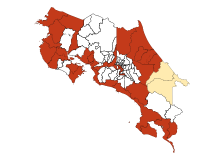
For this study, we used data for 32 different locations, from January 2000 to December 2019. This data corresponds to weekly dengue incidence records provided by the Ministry of Health of Costa Rica. The data is aggregated monthly and is square-root transformed and standardize [7].
Costa Rica is a mountainous country located between the Caribbean Sea and Pacific Ocean. Thus, we use indices related with both ocean anomalies. El Niño Southern Oscillation (ENSO) is a natural phenomenon in the ocean-atmospheric system over the tropical Pacific; it is responsible for some anomalies such as changes in the sea surface temperatures (SST) [23]. For this research, El Niño 1+2, El Niño 3, El Niño 4, and El Niño 3.4 indices [20] were used. Data were accessed at [https://www.cpc.ncep.noaa.gov/data/indices/ersst5.nino.mth.81-10.ascii]. Information related to anomalies in the Atlantic Ocean is measured with the TNA index, abbreviation of Tropical North Atlantic, provides information on sea surface temperatures in the North-Eastern Tropical Atlantic Ocean [34, 50]. Data are available at [https://www.esrl.noaa.gov/psd/data/correlation/tna.data].
Normalized Difference Water Index (NDWI) represents the changes in the liquid water content of the leaves, giving a picture of the water stress of the vegetationr [36, 21, 16]. The time series of the Enhanced Vegetation Index (EVI) and the Normalized Difference Vegetation Index (NDVI) provide spatial and temporal information about vegetation [22]. The NDVI has been widely used for remote sensing of vegetation and has been applied to mosquito studies and vector-borne diseases [47, 19, 27]. EVI responds to canopy structural variations, including leaf area index (LAI), canopy type, plant physiognomy, and canopy architecture, and NDVI is more sensitive to chlorophyll. The two vegetation indices complement each other. [28]. Land Surface Temperature (LST) is defined as a measure of how hot the surface of the Earth would feel to the touch [51]. These last indices where download using the R package MODIS Tools, which extracts the information from MODIS Land Products Subsets [https://modis.ornl.gov/data/modis_webservice.html]. The MOD13Q1 product was used to EVI, NDVI, and NDVI data, and the MOD11A2 product to the night and day LST data.
2.2 Wavelets analysis
Wavelets have been used to study time series with different purposes: to evaluate the main characteristics of non-stationary time series [43, 7, 9, 31, 24, 14, 41], to analyze spatial patterns [7, 45], to study the relationship between population and environmental time series; finding the phase and/or synchrony patterns [9, 24, 7], and to study multiple time series [15, 1]. Here, we used wavelet analysis to study patterns in dengue incidence in Costa Rica and identify its correlation with specific climate and vegetation variables in 32 different locations.
2.2.1 Wavelet power spectra
The wavelet analysis is based on a wavelet transform defined as
| (1) |
where denotes the complex conjugate form and represent a family of functions derived from a single function called the “mother wavelet”. The signal is decomposed in these functions which can be expressed in terms of two parameters, one for the time position , and the other for the scale of the wavelets .
| (2) |
| (3) |
The local amplitude of any periodic component of the time series and how it evolves with time, can be retrieved from the modulus of its wavelet transform [39].
| (4) |
The square of the amplitude has an interpretation as time-frequency (or time-period) called the wavelet power spectrum [3].
| (5) |
2.2.2 Wavelet coherence and phase difference
To quantify the time series synchronization between dengue and the different climate and vegetation variables, we compute the wavelet coherence given by
| (6) |
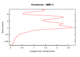
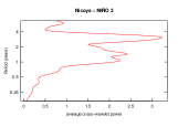
The angle brackets indicate smoothing in both time and frequency, and are the wavelet transform of the series and , respectively. is the cross-wavelet transform [7]. The value of range between 0 and 1, where 1 represent a perfect linear relationship between the time series and . Additional to this analysis, it is possible to compute the phase difference associated to the two signals, which gives information about series synchronization (i.e., in phase or out of phase). The Morlet wavelet is a complex wavelet, so the phase difference can be computed in terms of the real () and the imaginary () part, as shown in (7)
| (7) |
The instantaneous time lag between the time series and is also computed [7].
Furthermore, Torrence and Compo [46] offer a description of wavelet analysis and Cazellez et al. offer a perspective of the use of these techniques in ecological [5, 6] or epidemic scenarios [4].
All of the computations were done by using R version 2.4 (www.R-project.org) [44] and the wavelet time series analyses were done with the algorithms implemented in the R package WaveletComp version 1.1 [39]. All significance levels were based on 1000 bootstrap series and, to test the null hypothesis of non-periodicity, significance is evaluated with simulation algorithms in which surrogate time series are provided with a similar spectrum (AR time series). [39, 38].
3 Results
3.1 Wavelet analysis – dengue periodicity
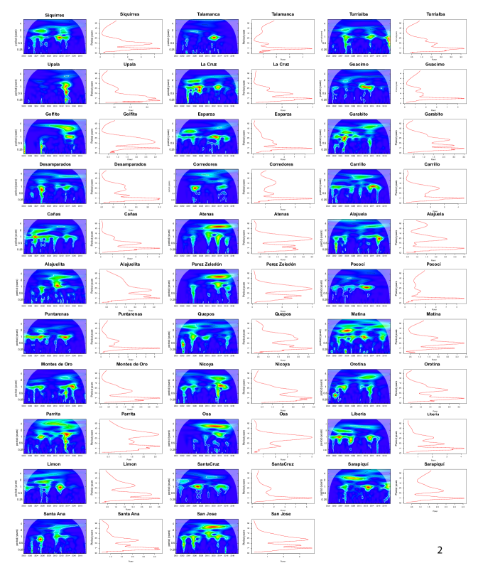
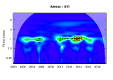
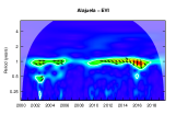
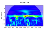
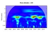
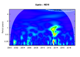
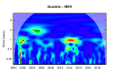
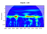
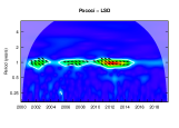
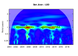
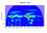
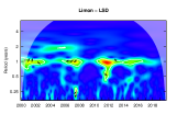
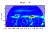
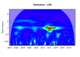
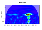
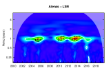
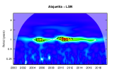
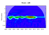
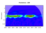
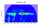
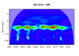
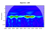
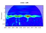
In general, wavelet time series analysis revealed that the dominant periods for the incidence of dengue, in the 32 municipalities, are in the bands of 1, 2, and 3-yr, in accord with the periodicity range of dengue in Vietnam [45], Perú [10] and Thailand [12, 7]. Periods of 4 and 6-yr are observed in Siquirres, Talamanca, Turrialba, Upala, Golfito, Alajuela, Puntarenas, Matina, Osa, Santa Ana, Limón, and Atenas, but this must be interpreted cautiously because of the short length of the time series. These periods are not stationary, they vary over time and space. Before 2008, the cycles of 1 and 2-yr leading in most locations. But, after 2008, the prevalent dengue periodicity change to cycles of 1 and 3-yr (see Figure 2). The years 2008-2010 mark a decrease period in the variability of dengue incidence.


3.2 Coherence and phase analyses – synchrony between dengue incidence, climate and vegetation variables
For each time series, the wavelet power spectrum is first calculated to determine the dominant periods individually and then the coherence between each covariate and the incidence of dengue is calculated.
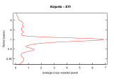
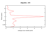
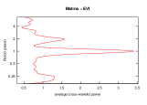
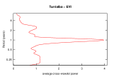
Enhanced Vegetation Index (EVI)
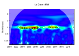
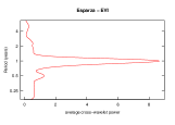
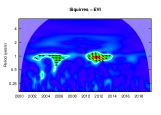
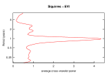
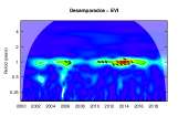
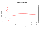
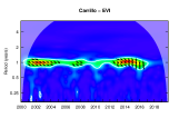
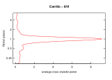
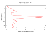
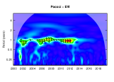
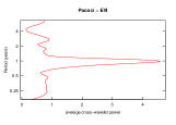
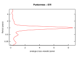
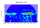
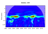
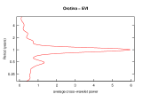
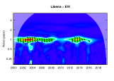
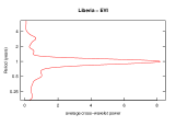
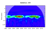
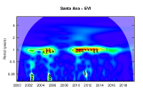
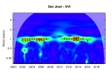
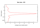
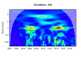
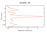
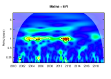
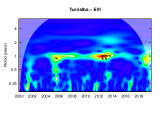
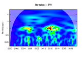
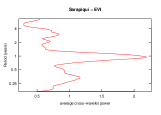
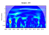
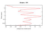
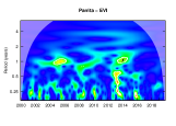
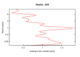
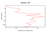
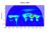
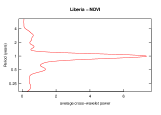
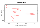
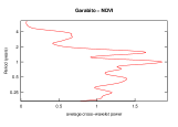
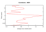
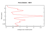
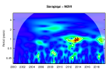
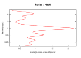
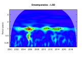
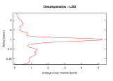
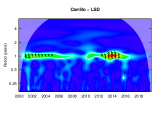
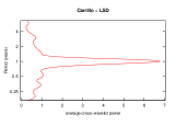
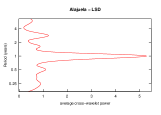
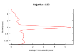
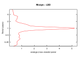
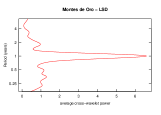
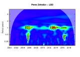
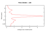
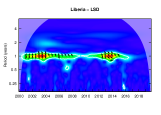
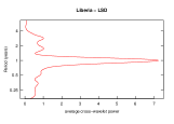
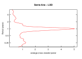
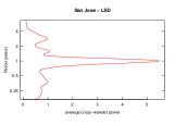
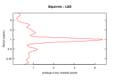
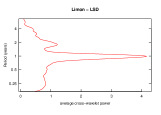
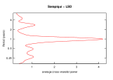
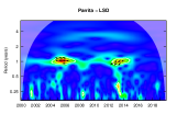
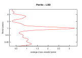
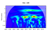
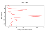
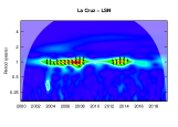
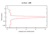
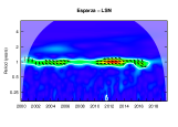
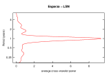
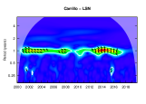
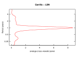
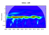
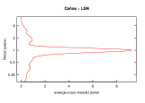
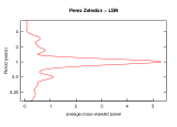
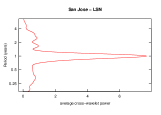
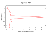
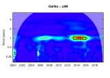
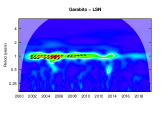
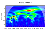
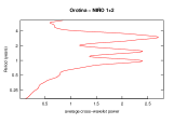
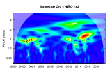
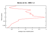
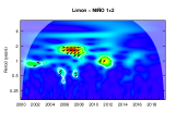
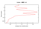
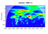
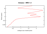
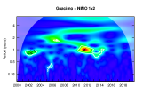
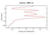
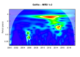
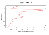
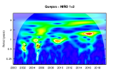
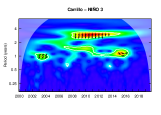
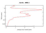
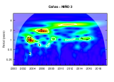
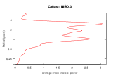
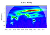
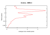
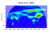
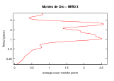
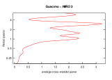
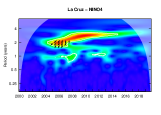
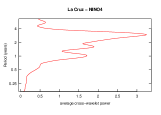
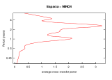
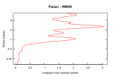
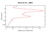
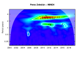
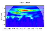
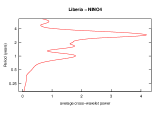
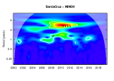
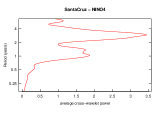
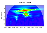
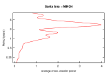
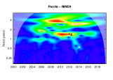
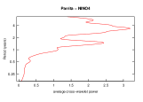
The index of vegetation shows a continues band for the period of 1-yr in the municipalities of La Cruz, Esparza, Santa Cruz, San José, Santa Ana, Perez Zeledón, Puntarenas, Carrillo, Cañas, Atenas, Alajuelita, Alajuela, Nicoya, Orotina, Desamparados, and Liberia. On the other hand, Siquirries, Turrialba, Pococí, Matina, Montes de Oro, Osa, Corredores, Guacimo, Limón have short time interval whit a significant periodicity on the scale of 1-yr. Golfito, Talamanca, Parrita, Upala, Quepos, Garabito, and Sarapiquí do not reach significance in any period when simulations are compared to the null hypothesis.
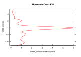
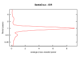
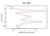
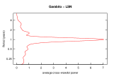
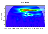
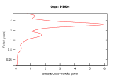
Wavelet coherence analysis shows that EVI is significantly associated with dengue incidence in the 1-yr periodic band, for all municipalities except Quepos, Parrita, Upala, Golfito, and Garabito. For these places where there is no marked annual seasonality for the vegetation indices (Turrialba, Matina, Osa, Corredores, Guacimo, Limón, Talamanca, and Sarapiquí) the correlation with dengue incidence present small areas of high significance (see Figure S1).
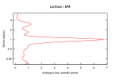
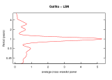
Phase differences (see supplementary material) suggest that the annual wave of dengue and EVI are in phase in all localities with an approximate lag of 3 months. Something to highlight is that in Osa, a continuous band for the vegetation index is recorded in the period of 1-yr after 2011, and one year later, a band period with the same scale for the incidence of dengue is shown with a strong correlation with EVI from 2012 to 2017.
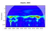
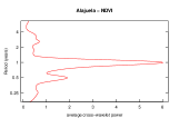
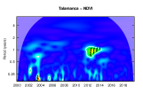
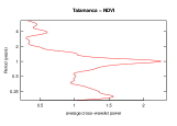
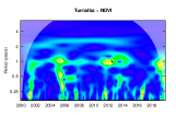
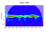
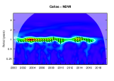
Normalized Difference Vegetation Index (NDVI)
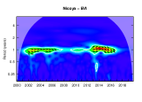
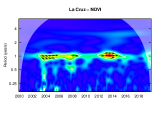
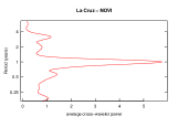
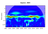
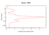
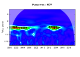
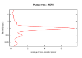
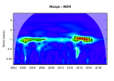
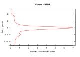
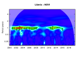
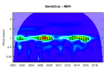
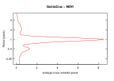
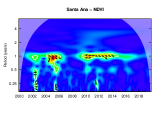
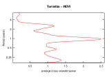
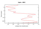
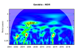
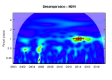
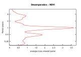
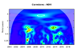
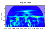
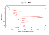
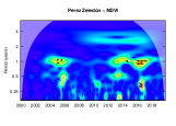
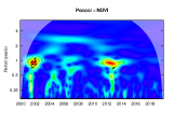
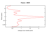
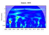
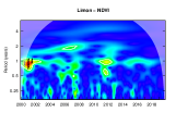
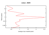
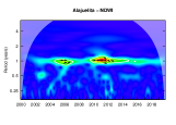
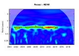
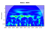
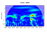
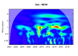
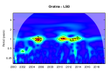
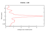
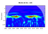
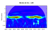
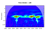
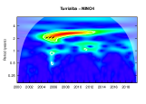
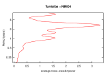
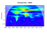
For NDVI, the wavelet analysis shows a marked and significant annual periodicity over time in the municipalities of La Cruz, Esparza, Santa Cruz, Santa Ana, Carrillo, Cañas, Alajuela, Nicoya, Libera, Puntarenas, Atenas, and Orotina. For the rest of the localities, there is no correlation or the significant area is present in short periods throughout the time.
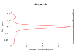
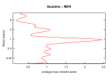
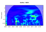
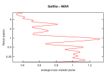
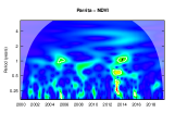
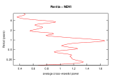
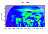
Analyzing the direct association between the incidence of dengue and the NDVI, a significant local coherence is observed in the 1-yr band for all municipalities listed above, where the annual periodicity of the NDVI is relevant. The correlation between dengue cases and DNVI for Siquirres, Desamparados, Peréz Zeledón, Pococí, Montes de Oro, Corredores, Sarapiquí, Guacimo, Talamanca, and Upala happen only in small interval of time. For Alajuenlita, Matina, Turrialba, Osa, Quepos, Parrita, Limón, Golfito, and Garabito there is not correlation (see Figure S2).
The phase difference (see supplementary material) reveals that the time series are in-phase. With total sync or an approximate delay of 3 months in Alajuela, Atenas, Cañas, Carrillo, Desamparados, Esparza, La Cruz, Liberia, Nicoya, Puntarenas, Santa Ana, and Santa Cruz, where an increase in the vegetation index is followed by a rise in dengue cases.
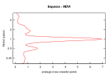
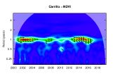
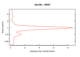
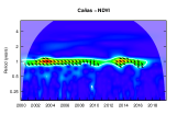
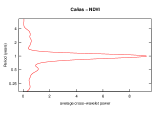
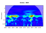
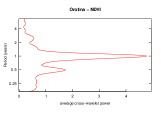
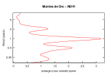
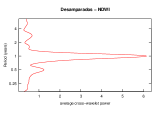
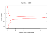
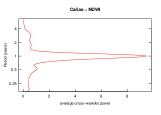
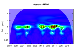
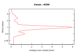
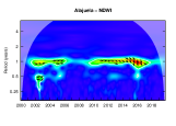
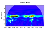
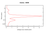
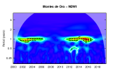
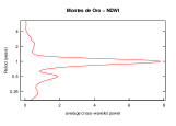
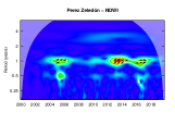
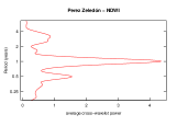
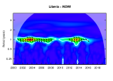
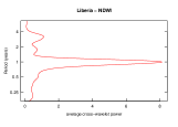
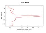
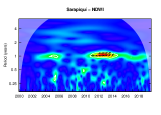
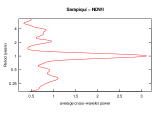
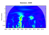
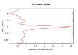
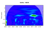
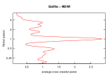
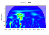
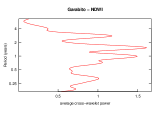
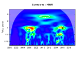
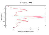
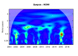
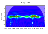
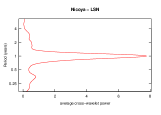
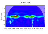
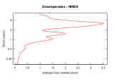
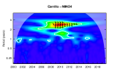
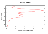
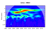
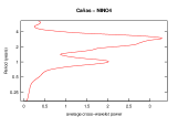
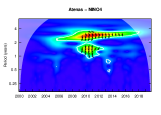
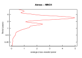
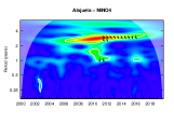
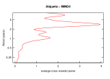
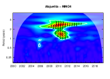
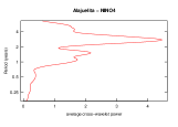
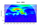
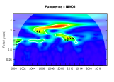
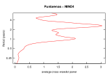
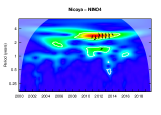
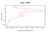
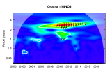
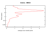
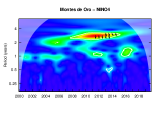
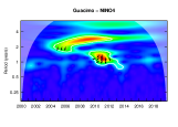
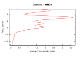
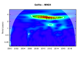
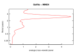
Normalized Difference Water Index (NDWI)
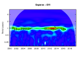
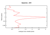
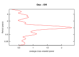
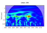
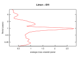
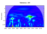
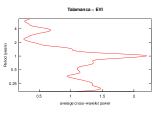
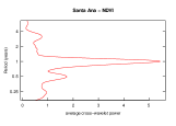
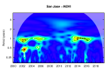
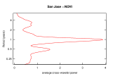
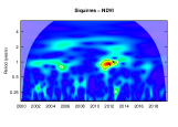
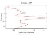
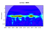
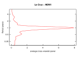
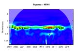
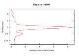
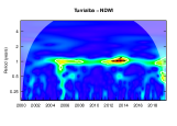
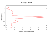
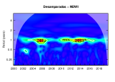
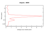
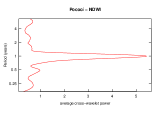
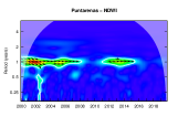
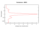
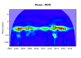
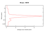
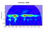
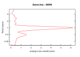
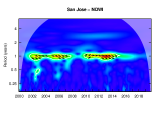
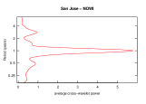
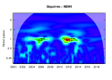
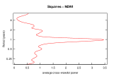
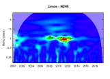
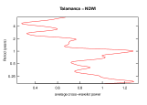
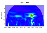
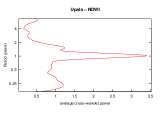
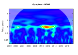
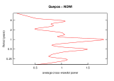
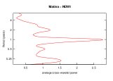
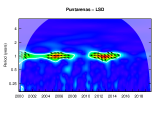
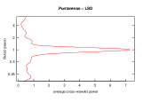
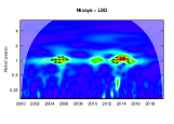
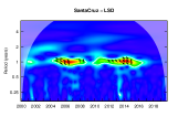
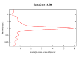
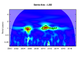
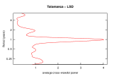
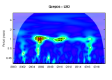
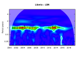
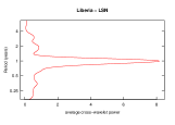
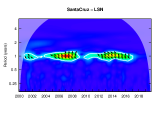
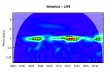
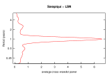
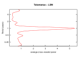
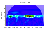
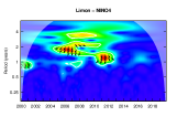
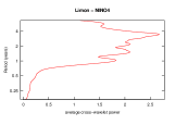
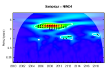
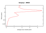
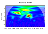
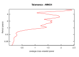
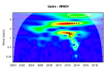
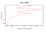
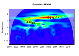
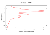
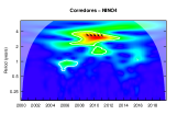
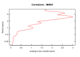
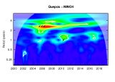
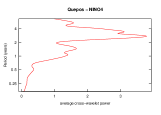
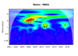
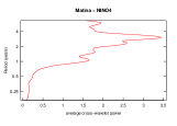
Similar to the results for EVI and NDVI, the wavelet coherence analysis for NDWI shows a high and significant coherence for the 1-yr periodic mode with the places located in the center and the North Pacific of the country (La Cruz, Esparza, Desamparados, Carrillo, Cañas, Atenas, Alajuela, Alajuelita, Pococí, Puntarenas, Montes de Oro, Nicoya, Orotina, Liberia, Santa Cruz, Santa Ana, and San José). For those places, the wavelet analysis of the NDWI time series shows a continuous high significant area in the period of one year throughout time. A weaker correlation is observed with the municipalities of Siquirres, Turrialba, Parrita, Corredores, Golfito, Sarapiquí, Matina, Limón, and Upala. There is not correlation in the municipalities of Talamanca, Guacimo, Garabito, and Quepos (see Figure S3).
The two-time series are in phase with a delay time of zero (full synchronization) at three months. NDWI is the leading time series in cities located in the North Pacific and Central Regions. While the leading series is not clearly defined in most of the municipalities of the Atlantic and the South Pacific.
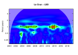
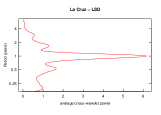
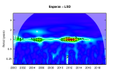
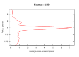
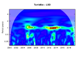
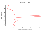
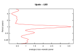
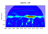
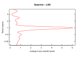
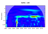
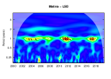
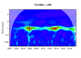
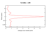
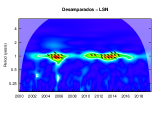
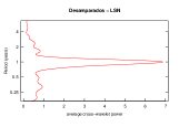
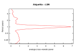
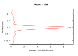
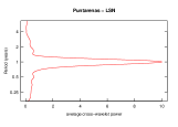
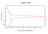
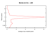
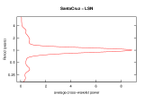
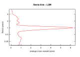
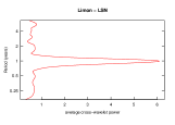
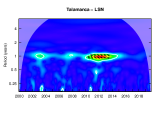
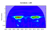
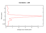
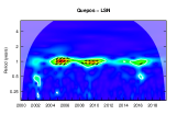
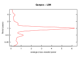
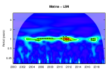
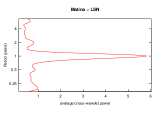
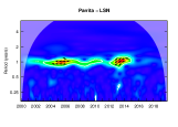
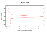
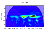
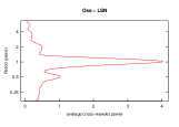
Land Surface Temperature (LST)
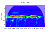
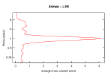
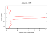
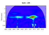
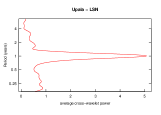
Wavelet power spectrum analysis shows a strong annual component for LSN and LSD in all municipalities. For LSN, a continuous band in the 1-yr is present in all cantons, while for LSD only a continuous band is observed for La Cruz, Esparza, Desamparados, Carrillo, Liberia, Osa, and Pococí and a non-stationary behavior, in the same scale, for the rest of localities.
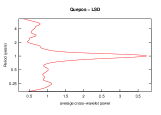
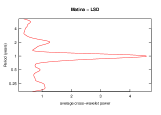
Wavelet coherence evinces a significant association of dengue incidence with seasonal temperature in the dominant wave of 1-yr. The lapse of time over which these patterns are correlated and are statistically significant varied across the time and geographic locations (see Figures S4-S5).
The phase difference for the 1-yr band indicates that land surface temperature and dengue incidence signal are out of phase. The positive peak of dengue lags behind the negative peak of the land surface temperature with a difference of 3 (in-phase) to 6 (completely mirror images of each other) months. This pattern is regular in all municipalities over time, except for Limón, Corredores, Cañas, Atenas, Perez Zeledón, Quepos, Parrita, Garabito, and Upala, where the incidence of dengue leads over LSD, LSN or both (supplementary material).
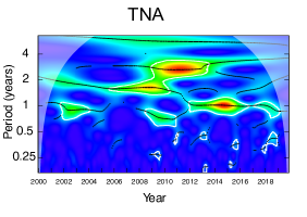
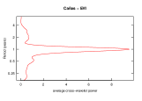
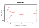
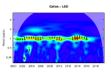
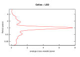
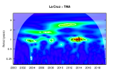
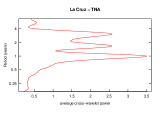
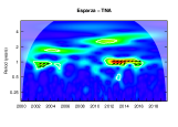
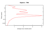
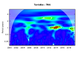
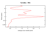
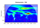
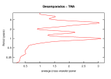
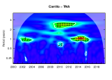
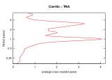
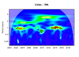
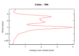
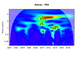
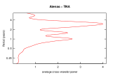
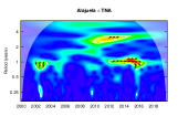
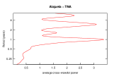
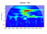
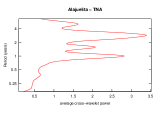
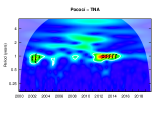
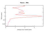
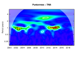
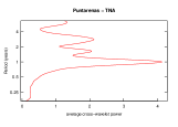
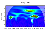
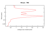
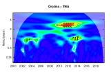
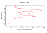
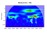
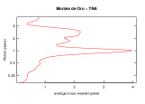
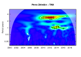
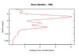
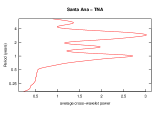
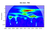
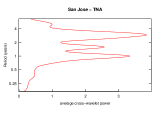
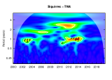
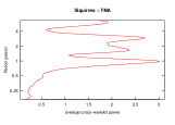
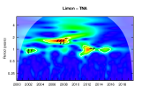
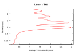
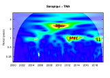
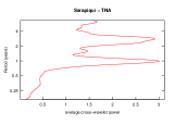
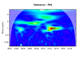
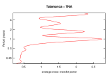
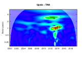
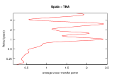
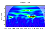
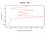
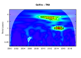
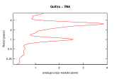
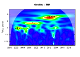
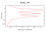
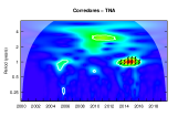
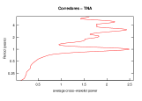
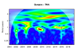
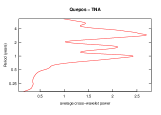
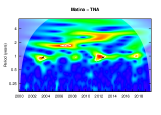
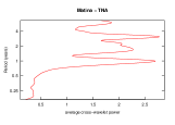
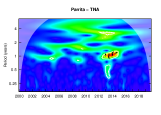
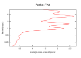
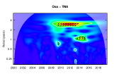
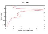
Tropical North Atlantic (TNA)
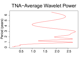
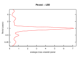
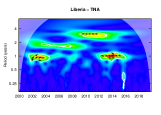
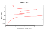
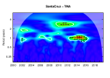
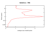
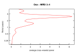
The wavelet power spectrum for the TNA data shows a dominant period in the 1-yr, 18-month (1.5-yr), 3-yr, and 6-yr range (see Figure 4). The period of 6-yr should be taken carefully due to the series length.
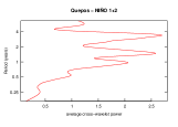
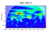
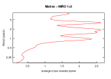
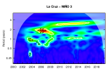
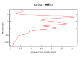
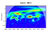
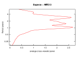
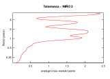
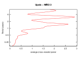
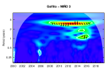
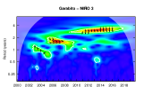
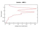
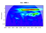
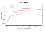
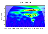
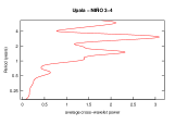
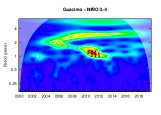
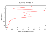
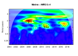
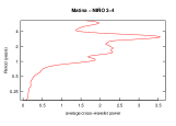
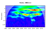
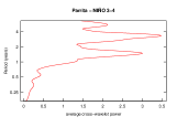
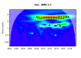
The wavelet coherence analysis shows a significant correlation between the TNA index and the incidence of dengue in all municipalities (except for Matina and Quepos), especially in the band corresponding to the periods of 1 and 3-ys (see Figure S6). After 2011, there is a significant correlation between the time series in the one-year band for all localities except Alajuelita and Garabito.
For Desamparados, Santa Cruz, San José, Santa Ana, Pérez Zeledón, Carrillo, Atenas, Alajuelita, Alajuela, Nicoya, Orotina, Osa, Montes de Oro, Golfito, Upala, Garabito, and Sarapiquí, the phase difference reveals that the dengue wave is in perfect synchronization with the TNA wave in the 3-yr band from 2009 to 2014, approximately. For all locations, TNA and dengue incidence signals are in phase, but the lagging and leading wave changes with geographic location and over time (see supplementary material).
Sea surface temperatures (ENSO SST)
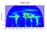
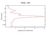
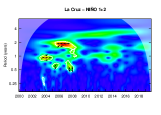
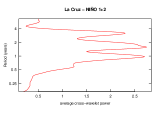
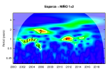
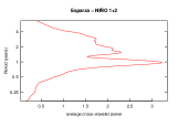
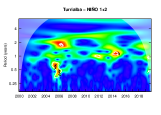
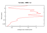
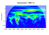
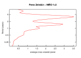
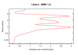
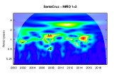
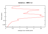
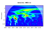
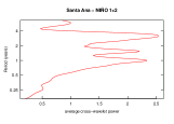
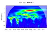
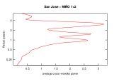
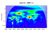
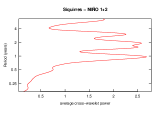
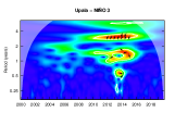
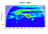
The wavelet power spectrum was performed for the four different Niño indices: Niño 1 + 2, Niño 3, Niño 3.4, Niño 4 (see Figure 5). The results show that the dominant non-stationary peaks, for the four indices, are in the 1-yr, 1.5-yr, and 3-yr bands (see Figure 5).
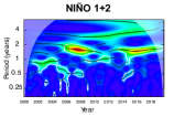
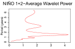
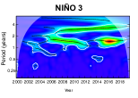
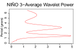
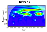
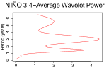
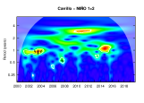
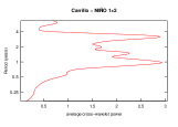
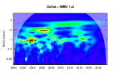
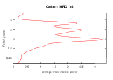
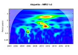
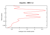
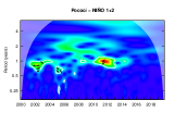
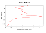
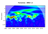
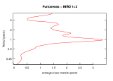
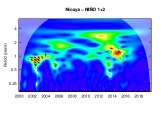
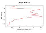
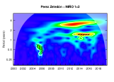
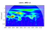
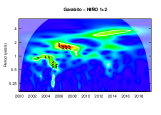
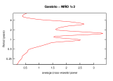
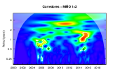
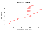
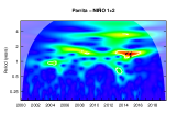
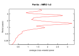
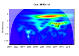
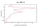
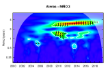
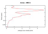
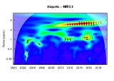
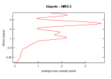
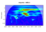
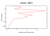
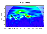
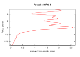
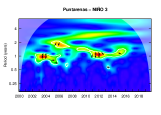
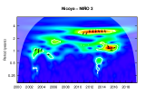
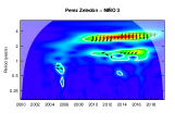
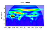
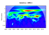
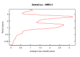
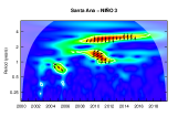
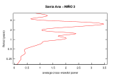
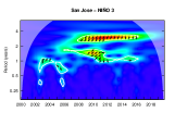
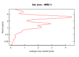
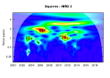
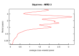
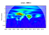
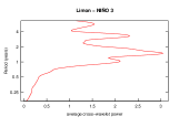
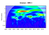
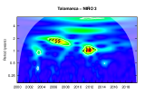
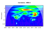
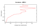
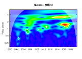
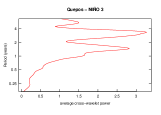
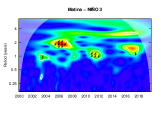
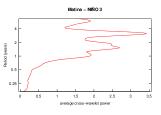
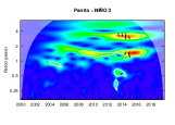
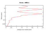
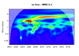
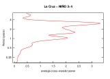
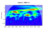
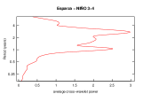
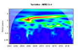
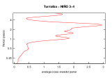
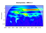
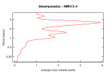
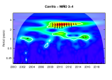
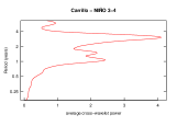
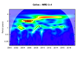
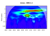
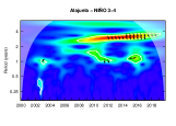
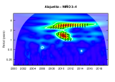
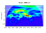
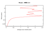
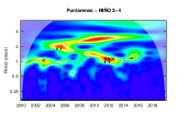
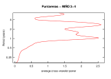
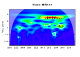
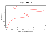
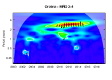
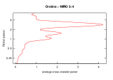
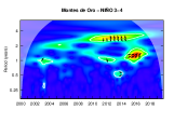
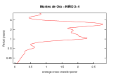
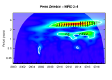
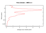
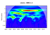
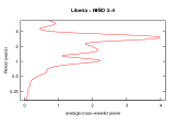
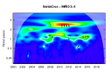
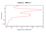
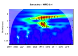
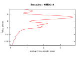
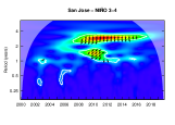
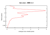
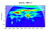
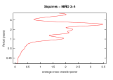
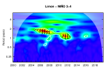
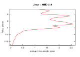
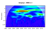
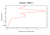
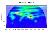
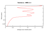
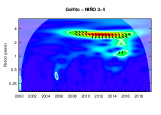
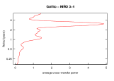
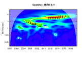
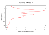
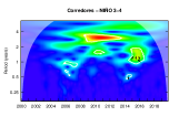
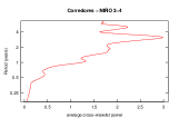
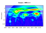
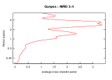
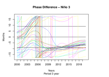
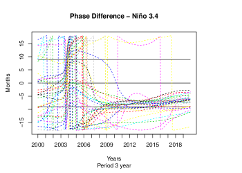
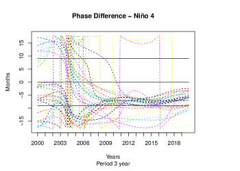
The coherence between the incidence of dengue and the Niño 1 + 2 index is not clear. There is possible to identify small areas of significance between this and the dengue incidence in some places in the Pacific (Liberia, Puntarenas, Esparza, Garabito, Montes de Oro, Nicoya, Orotina and Carrillo) and the Atlantic (Matina, Siquirris, Pococí, and Limón) in the band of 1 year, from 2001 to 2007 approximately. On the other hand, Niño 3, 3.4, and 4 are correlated with dengue incidence in the period of 1, 1.5, 2, and 3-yr. The correlation is non-stationary and vary over time and geographically. However, there is a strong correlation between those indices and dengue incidence in most of the localities in the period of 3-yr (see Figure 6).
Canton EVI NDVI NDWI LSD LSN TNA NIÑO 3 NIÑO 34 NIÑO 4 La Cruz x x x x x P1 P3 P3 P3 Esparza x x x x x P1 – P3 P3 Puntarenas x x x x x P1 – P3 P3 Carrillo x x x x x P1 P3 P3 P3 Cañas x x x x x P1 – P3 P3 Atenas x x x x x P1 P3 P3 P3 Alajuela x x x x x P1 P3 P3 P3 Nicoya x x x x x P1 P3 P3 P3 Orotina x x x x x P1 P3 P3 P3 Liberia x x x x x P1 P3 P3 P3 Santa Cruz x x x x x P1 P3 P3 P3 Santa Ana x x x x x P1 P3 P3 P3 San José x 2001/2007-2013/2017 x x x P1 P3 P3 P3 Alajuelita x x x x – P3 P3 P3 Matina 2010/2013 x x – – P3 Turrialba 2010/2014 2004/2008-2011/2015 x x P1 – P3 P3 Siquirres x 2011/2013 2003/2008-2010/2014 x x P1 – P3 P3 Desamparados x 2012/2017 x x x P1 P3 P3 P3 Perez Zeledón x 2004/2006-2013/2018 x x x P1 P3 P3 P3 Pococí x 2001/2003-2011/2014 x x x P1 – – P3 Montes de oro x 2000/2003-2013/2017 x x x P1 – P3 P3 Corredores 2005/2007 - 2013/2017 2013/2015 2005/2008-2015/2017 x x P1 P3 – P3 Limón 2010/2013 2007/2013 x x P1 – – – Talamanca 2011/2014 2011/2014 x x P1 P1 – – Sarapiquí 2011/2014 2012/2015 2011/2015 x x P1 – – P3 Guacimo 2010/2015 2002-2011/2014 2010/2014 x x P1 – – P3 Osa 2012/2017 2013/2016 x x P1 P3 P3 P3 Quepos x x – – P3 Parrita 2013/2014 x x P1 P3 P3 P3 Upala 2013 2012/2015 x x P1 P3 P3 P3 Golfito 2013/2017 x x P1 P3 P3 P3 Garabito x x – P3 P3 P3
Index Period and Phase Lag EVI NDVI NDWI Vegetation indices showed a strong correlation with dengue incidence in the 1-yr period. The time series move in-phase. The lag is approximately 3 months, however, there are periods when both signals are in sync. LST (LSN-LSD) LSN and LSD are correlated with dengue indices in the period of 1-yr. Time series move out of phase. 3-6 Months TNA The TNA series has dominant periods of 1, 1.5, and 3 years. It is in phase with the time series of dengue cases and there is a strong correlation with those in the periods of 1-yr and 3-yrs. 3 Months in the band of 1-yr 6 Months in the band of 3-yr ENSO SST Non-stationary period in the band of 1-yr and 3 yr. Lag in the period of 1-yr. Lag in the period of 3-yr. Niño 3 3 Months 15 Months Niño 4 3-6 Months 15 Months
4 Discussion
Wavelet analysis was performed over monthly time series of dengue incidence and six different satellite climate and vegetation variables in Costa Rica (i) to detect and quantify dengue periodicity in 32 different cantons and (ii) to associate the relationship between dengue incidence, climate and vegetation variables in those places.
Wavelet power spectra showed that the dominant periods of dengue in the 32 locations in Costa Rica are in the 1, 2, and 3-yr bands. These periods are not stationary; they vary over time and space. After 2008, a high area of significance in the period of 3-yr appears in most places which, according to the wavelet coherence analysis, dengue incidence correlates with the Niño 3, 3.4, 4, and TNA index in the same period.
The wavelet coherence analysis shows a strong correlation between the vegetation indices (EVI, NDVI, and NDWI) and the incidence of dengue in cantons located mainly in the center or North Pacific of the country. For cantons in the Atlantic or the South Pacific, the areas of significance are small or do not exist. The time series are in phase with a lag of 3 months, but there are some periods where the two series are in sync. The LSN and LSD indices are strongly correlated with the incidence of dengue in all municipalities. The time series are out-phase with a lag ranging from 3 to 6 months. The TNA is correlated with dengue cases in the periods of 1-yr and 3-ys. After 2011, there is a marked correlation in the 1-year band for all places except Matina, Quepos, Alajuelita, and Garabito. Niño 3, 3.4, and 4 show a significant correlation in different band periods, but the correlation in the 3-yr band is dominant in most localities. On the other hand, the correlation between the Niño 1 + 2 index and the incidence of dengue is less clear.
Weather and climate influence disease ecology on many levels creating complex dynamics. Although it is known that dengue dynamics can be affected by various climatic and vegetation variables, not all of them must be present for successful spread. Human factors, such as behavior, immunity, and socioeconomic factors, could also contribute to dengue spread and complexity. This analysis showed that even in the same country, the variables correlated with dengue cases could change, highlighting the importance of analyzing a localized way.
As far as we know, this is the first study for Costa Rica that incorporates a wide variety of climatic variables and considers the cantons of interest to the health authorities. This type of analysis provides a better understanding of the local dynamics of diseases, which allows for improved prediction models and health interventions at specific sites. It can be enriched with the incorporation of new socioeconomic variables and with a cluster approach, which allows characterizing the regions and identifying the conditions and characteristics shared by the different cantons.
References
- [1] Saeed Aghabozorgi, Ali Seyed Shirkhorshidi, and Teh Ying Wah. Time-series clustering–a decade review. Information Systems, 53:16–38, 2015.
- [2] Roberto Barrera, Manuel Amador, and Gary G Clark. Ecological factors influencing aedes aegypti (diptera: Culicidae) productivity in artificial containers in Salinas, Puerto Rico. Journal of medical entomology, 43(3):484–492, 2006.
- [3] René Carmona, Wen-Liang Hwang, and Bruno Torresani. Practical Time-Frequency Analysis: Gabor and wavelet transforms, with an implementation in S. Academic Press, 1998.
- [4] Bernard Cazelles, Kévin Cazelles, and Mario Chavez. Wavelet analysis in ecology and epidemiology: impact of statistical tests. Journal of the Royal Society Interface, 11(91):20130585, 2014.
- [5] Bernard Cazelles, Mario Chavez, Dominique Berteaux, Frédéric Ménard, Jon Olav Vik, Stéphanie Jenouvrier, and Nils C Stenseth. Wavelet analysis of ecological time series. Oecologia, 156(2):287–304, 2008.
- [6] Bernard Cazelles, Mario Chavez, Guillaume Constantin de Magny, Jean-Francois Guégan, and Simon Hales. Time-dependent spectral analysis of epidemiological time-series with wavelets. Journal of the Royal Society Interface, 4(15):625–636, 2007.
- [7] Bernard Cazelles, Mario Chavez, Anthony J McMichael, and Simon Hales. Nonstationary influence of el nino on the synchronous dengue epidemics in thailand. PLoS medicine, 2(4), 2005.
- [8] Luis Fernando Chaves, José Angel Valerín Cordero, Gabriela Delgado, Carlos Aguilar-Avendaño, Ezequías Maynes, José Manuel Gutiérrez Alvarado, Melissa Ramírez Rojas, Luis Mario Romero, and Rodrigo Marín Rodríguez. Modeling the association between aedes aegypti ovitrap egg counts, multi-scale remotely sensed environmental data and arboviral cases at puntarenas, costa rica (2017–2018). Current Research in Parasitology and Vector-Borne Diseases, 1:100014, 2021.
- [9] Luis Fernando Chaves and Mercedes Pascual. Climate cycles and forecasts of cutaneous leishmaniasis, a nonstationary vector-borne disease. PLoS medicine, 3(8), 2006.
- [10] Gerardo Chowell, Bernard Cazelles, Helene Broutin, and Cesar V Munayco. The influence of geographic and climate factors on the timing of dengue epidemics in perú, 1994-2008. BMC infectious diseases, 11(1):164, 2011.
- [11] Sir SR Christophrs et al. Aëdes aegyptì (l.) the yellow fever mosquito; its life history, bionomics and structure. Aëdes aegyptì (L.) the yellow fever mosquito; its life history, bionomics and structure., 1960.
- [12] Derek AT Cummings, Rafael A Irizarry, Norden E Huang, Timothy P Endy, Ananda Nisalak, Kumnuan Ungchusak, and Donald S Burke. Travelling waves in the occurrence of dengue haemorrhagic fever in thailand. Nature, 427(6972):344–347, 2004.
- [13] Hoang Quoc Cuong, Nguyen Tran Hien, Tran Nhu Duong, Tran Vu Phong, Nguyen Nhat Cam, Jeremy Farrar, Vu Sinh Nam, Thai TD Khoa, and Peter Horby. Quantifying the emergence of dengue in hanoi, vietnam: 1998–2000. PLoS Negl Trop Dis, 9(5), 2016.
- [14] Hoang Quoc Cuong, Nguyen Thanh Vu, Bernard Cazelles, Maciej F Boni, Khoa TD Thai, Maia A Rabaa, Luong Chan Quang, Cameron P Simmons, Tran Ngoc Huu, and Katherine L Anders. Spatiotemporal dynamics of dengue epidemics, southern vietnam. Emerging infectious diseases, 19(6):945, 2013.
- [15] Pierpaolo D’Urso and Elizabeth Ann Maharaj. Wavelets-based clustering of multivariate time series. Fuzzy Sets and Systems, 193:33–61, 2012.
- [16] Earth Observing System. Ndvi. https://eos.com/ndwi/.
- [17] Kristie L Ebi and Joshua Nealon. Dengue in a changing climate. Environmental research, 151:115–123, 2016.
- [18] NDB Ehelepola, Kusalika Ariyaratne, WMNP Buddhadasa, Sunil Ratnayake, and Malani Wickramasinghe. A study of the correlation between dengue and weather in kandy city, sri lanka (2003-2012) and lessons learned. Infectious diseases of poverty, 4(1):1–15, 2015.
- [19] Elizabet Lilia Estallo, Francisco Felipe Luduena-Almeida, Andrés Mario Visintin, Carlos Marcelo Scavuzzo, Mario Alberto Lamfri, María Virginia Introini, Mario Zaidenberg, and Walter Ricardo Almirón. Effectiveness of normalized difference water index in modelling aedes aegypti house index. International journal of remote sensing, 33(13):4254–4265, 2012.
- [20] National Center for Atmospheric Research. Climate Data Guide. https://climatedataguide.ucar.edu/climate-data/nino-sst-indices-nino-12-3-34-4-oni-and-tni.
- [21] Bo-Cai Gao. Ndwi—a normalized difference water index for remote sensing of vegetation liquid water from space. Remote sensing of environment, 58(3):257–266, 1996.
- [22] GISGeography. What is NDVI (Normalized Difference Vegetation index? https://gisgeography.com/ndvi-normalized-difference-vegetation-index/, febrary 2018.
- [23] Deborah E Hanley, Mark A Bourassa, James J O’Brien, Shawn R Smith, and Elizabeth R Spade. A quantitative evaluation of enso indices. Journal of Climate, 16(8):1249–1258, 2003.
- [24] Michael A Johansson, Derek AT Cummings, and Gregory E Glass. Multiyear climate variability and dengue—el nino southern oscillation, weather, and dengue incidence in puerto rico, mexico, and thailand: a longitudinal data analysis. PLoS medicine, 6(11), 2009.
- [25] Mark R Jury. Climate influence on dengue epidemics in puerto rico. International journal of environmental health research, 18(5):323–334, 2008.
- [26] Korine N Kolivras. Changes in dengue risk potential in hawaii, usa, due to climate variability and change. Climate Research, 42(1):1–11, 2010.
- [27] JP Lacaux, YM Tourre, Cecile Vignolles, JA Ndione, and M Lafaye. Classification of ponds from high-spatial resolution remote sensing: Application to rift valley fever epidemics in senegal. Remote Sensing of Environment, 106(1):66–74, 2007.
- [28] Bunkei Matsushita, Wei Yang, Jin Chen, Yuyichi Onda, and Guoyu Qiu. Sensitivity of the enhanced vegetation index (evi) and normalized difference vegetation index (ndvi) to topographic effects: a case study in high-density cypress forest. Sensors, 7(11):2636–2651, 2007.
- [29] Cory W Morin, Andrew C Comrie, and Kacey Ernst. Climate and dengue transmission: evidence and implications. Environmental health perspectives, 121(11-12):1264–1272, 2013.
- [30] Oladimeji Mudele, Alejandro C Frery, Lucas FR Zanandrez, Alvaro E Eiras, and Paolo Gamba. Modeling dengue vector population with earth observation data and a generalized linear model. Acta Tropica, 215:105809, 2021.
- [31] Yoshiro Nagao and Katia Koelle. Decreases in dengue transmission may act to increase the incidence of dengue hemorrhagic fever. Proceedings of the National Academy of Sciences, 105(6):2238–2243, 2008.
- [32] Kanchana Nakhapakorn, Warisara Sancharoen, Auemphorn Mutchimwong, Supet Jirakajohnkool, Rattapon Onchang, Chawarat Rotejanaprasert, Kraichat Tantrakarnapa, and Richard Paul. Assessment of urban land surface temperature and vertical city associated with dengue incidences. Remote Sensing, 12(22):3802, 2020.
- [33] Narong Nitatpattana, Pratap Singhasivanon, Honda Kiyoshi, Haja Andrianasolo, Sutee Yoksan, J Gonzalez, and Philippe Barbazan. Potential association of dengue hemorrhagic fever incidence and remote senses land surface temperature, thailand, 1998. Southeast Asian journal of tropical medicine and public health, 38(3):427, 2007.
- [34] The State of the Ocean Climate. Tropical northern atlantic index (tna). https://stateoftheocean.osmc.noaa.gov/sur/atl/tna.php.
- [35] Pan-American Health Organization. Epidemiological update: Dengue - 7 february 2020 - paho/who — pan american health organization. https://www.paho.org/en/documents/epidemiological-update-dengue-7-february-2020. (Accessed on 03/27/2021).
- [36] Elisavet Parselia, Charalampos Kontoes, Alexia Tsouni, Christos Hadjichristodoulou, Ioannis Kioutsioukis, Gkikas Magiorkinis, and Nikolaos I Stilianakis. Satellite earth observation data in epidemiological modeling of malaria, dengue and west nile virus: A scoping review. Remote Sensing, 11(16):1862, 2019.
- [37] RA Ranga Prabodanie, Sergei Schreider, Bernard Cazelles, and Lewi Stone. Coherence of dengue incidence and climate in the wet and dry zones of sri lanka. Science of The Total Environment, 724:138269, 2020.
- [38] Angi Roesch, Harald Schmidbauer, and Maintainer Angi Roesch. Package ‘waveletcomp’. The Comprehensive R Archive Network 2014, 2014.
- [39] Angi Rösch and Harald Schmidbauer. Waveletcomp 1.1: A guided tour through the r package. URL: http://www. hsstat. com/projects/WaveletComp/WaveletComp_guided_tour. pdf, 2016.
- [40] Donald S Shepard, Laurent Coudeville, Yara A Halasa, Betzana Zambrano, and Gustavo H Dayan. Economic impact of dengue illness in the americas. The American journal of tropical medicine and hygiene, 84(2):200–207, 2011.
- [41] Taynana C Simoes, Claudia T Codeço, Aline A Nobre, and Alvaro E Eiras. Modeling the non-stationary climate dependent temporal dynamics of aedes aegypti. PLoS One, 8(8), 2013.
- [42] Anna M Stewart-Ibarra, Ángel G Muñoz, Sadie J Ryan, Efraín Beltrán Ayala, Mercy J Borbor-Cordova, Julia L Finkelstein, Raúl Mejía, Tania Ordoñez, G Cristina Recalde-Coronel, and Keytia Rivero. Spatiotemporal clustering, climate periodicity, and social-ecological risk factors for dengue during an outbreak in machala, ecuador, in 2010. BMC infectious diseases, 14(1):1–16, 2014.
- [43] Thiyanga Talagala and Ravindra Lokupitiya. Wavelet analysis of dengue transmission pattern in sri lanka. Int J Mosquito Res, 2(4):13–18, 2015.
- [44] R Core Team et al. R: A language and environment for statistical computing. URL:http://www.R-project.org/, 2013.
- [45] Khoa TD Thai, Bernard Cazelles, Nam Van Nguyen, Long Thi Vo, Maciej F Boni, Jeremy Farrar, Cameron P Simmons, H Rogier van Doorn, and Peter J de Vries. Dengue dynamics in binh thuan province, southern vietnam: periodicity, synchronicity and climate variability. PLoS neglected tropical diseases, 4(7), 2010.
- [46] Christopher Torrence and Gilbert P Compo. A practical guide to wavelet analysis. Bulletin of the American Meteorological society, 79(1):61–78, 1998.
- [47] Adriana Troyo, Douglas O Fuller, Olger Calderón-Arguedas, Mayra E Solano, and John C Beier. Urban structure and dengue incidence in puntarenas, costa rica. Singapore journal of tropical geography, 30(2):265–282, 2009.
- [48] W Tun-Lin, TR Burkot, and BH Kay. Effects of temperature and larval diet on development 476 rates and survival of the dengue vector aedes aegypti in north queensland, australia. Med, 477:31–37, 2000.
- [49] WHO. Dengue and severe dengue. https://www.who.int/news-room/fact-sheets/detail/dengue-and-severe-dengue. (Accessed on 03/22/2021).
- [50] Lixin Wu and Zhengyu Liu. Is tropical atlantic variability driven by the north atlantic oscillation? Geophysical research letters, 29(13):31–1, 2002.
- [51] Y Yu, Y Liu, and P Yu. Land surface temperature product development for jpss and goes-r missions. ”in comprenhesive remote sensing”. Earth’s Energy Budget, 5, 2018.
- [52] Zhilin Zeng, Juan Zhan, Liyuan Chen, Huilong Chen, and Sheng Cheng. Global, regional, and national dengue burden from 1990 to 2017: A systematic analysis based on the global burden of disease study 2017. EClinicalMedicine, 32:100712, 2021.
Supplementary Material: Wavelet Analysis of Dengue Incidence and its Correlation with Weather and Vegetation Variables in Costa Rica
Yury E. García, Luis A. Barboza, Fabio Sanchez,
Paola Vásquez, Juan G. Calvo.
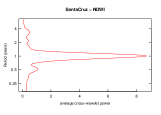
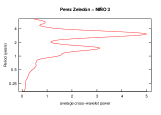
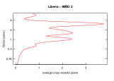
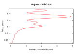
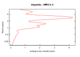
Wavelet coherence and average cross-wavelet power between dengue incidence and EVI


Wavelet coherence and average cross-wavelet power between dengue incidence and NDVI
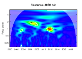
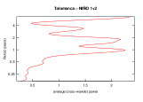
Wavelet coherence and average cross-wavelet power between dengue incidence and NDWI


Wavelet coherence and average cross-wavelet power between dengue incidence and LSD


Wavelet coherence and average cross-wavelet power between dengue incidence and LSN


Wavelet coherence and average cross-wavelet power between dengue incidence and TNA

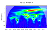
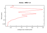
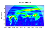
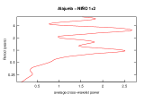
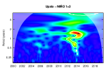
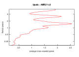
Wavelet coherence and average cross-wavelet power between dengue incidence and Niño 1+2

Wavelet coherence and average cross-wavelet power between dengue incidence and Niño 3


Wavelet coherence and average cross-wavelet power between dengue incidence and Niño 3.4
//
Wavelet coherence and average cross-wavelet power between dengue incidence and Niño 4


Phase difference
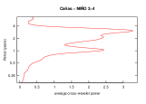
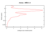
Phase difference provides information about time series synchronization [39]. An absolute value less (larger) than or the equivalent period (days, weeks, months, or years) indicates that the two series move in phase (anti-phase, respectively). The sign of the phase difference shows which series is the leading one in this relationship. In the figures below, the horizontal lines indicate the points corresponding to and .
The left panels in Figures S11, S12, S13 show that the incidence of dengue and the time series for EVI, NDVI, and NDWI are in phase. However, the leading and lagging series change over time. When the difference is negative, the climate and vegetation index is the leading series, if it is positive, the incidence of dengue is the leading one. The lag range between 0 to 3 months. On the other hand, the panels on the right present the series without consistent behavior over time.
Figure S14 show that the LSD and LSN are out-phase with dengue incidence. Positive values indicate that LSD and LSN are the lagging series with a lag period from 3 to 6 months.
Figures S15 and S16 shows that most of the cantons are in phase with the Niño 3, Niño 3.4, and Niño 4 in the last years.
Canton NDVI NDVI NDWI LSD LSN TNA NIÑO 3 NIÑO 34 NIÑO 4 La Cruz x x x x x P1-P1.5-P3 ¡P1-P1.5-P3 P1-P1.5-P3 P3 Esparza x x x x x P1-P1.5-P3 P1-P1.5-P3 P1-P3 P1-P3 Puntarenas x x x x x P1-P3 P1 P1-P3 P1-P3 Carrillo x x x x x P1-P3 P1-P3 P1-P1.5-P3 P3 canas x x x x x P1 P1-P2-P3 P1-P3 P1-P3 Atenas x x x x x P1-P3 P3 P1.5-P3 P1-P3 Alajuela x x x x x P1-P3 P3 P1-P1.5-P3 P3 Nicoya x x x x x P1-P3 P1-P3 P3 P3 Orotina x x x x x P1-P3 P3 P3 P3 Liberia x x x x x P1-P2-P3 P1-P2-P3 P1-P2-P3 P1-P3 Santa Cruz x x x x x P1-P3 P1-P3 P1-P3 P1-P3 Santa Ana x x x x x P1-P3 P1-P3 P1-P3-P1.5 P1.5-P3 San José x x x x x P1-P3 P1-P1.5-P3 P1-P1.5-P3 P1.5-P3 Alajuelita x x x x P1-P1.5-P3 P3 P1.5-P3 P1.5-P3 Matina x x x P1-P2 P1-P2-P3 P3 Turrialba x x x x P1-P3 P1.5 P3 P3 Siquirres x 2011/2013 2003/2008-2010/2014 x x P1-P3 P1-P1.5-P3 P1-P2-P3 P1-P3 Desamparados x 2012/2017 x x x P1-P3 P3 P3 P1.5-P3 Perez Zeledón x 2004/2006-2013/2018 x 2004/2006-2013/2018 x P1-P3 P1-P3 P1.5-P3 P1-P3 Pococí x 2001/2003-2011/2014 x x x P1 P1 P1-P2 P1-P3 Montes de Oro x 2000/2003-2013/2017 x x x P1-P3 P1-P3 P1-P3 P1-P3 Corredores 2005/2007 - 2013/2017 2013/2015 2005/2008-2015/2017 2004/2008-2013/2017 2004/2008-2013/2017 P1 P1.5-P3 P3 P3 Limón 2010/2013 2007/2013 x x P1-P1.5 P1-P1.5 P1-P1.5 P1-P1.5-P3 Talamanca 2011/2014 2011/2014 2010/2015 2010/2015 P1 P1-P2 P1-P1.5-P3 P1-P1.5-P3 Sarapiquí 2011/2014 2012/2015 2011/2015 x x P1-P3 P1-P2 P1-P3 P1-P3 Guacimo 2010/2015 2002-2011/2014 2010/2014 2010/2015 x P1 P1 P1-P1.5-P3 P1-P1.5-P3 Osa 2012/2017 2013/2016 2008/2011 - 2013/2015 2008/2011-2013/2018 P1-P3 P3 P1.5-P3 P3 Quepos 2004/2007 - 2009/2011 x P1-P3 P1.5-P3 P3 Parrita 2013/2014 2004/2007 - 2013/2015 x P1 P1.5-P3 P1.5-P3 P1.5-P3 Upala 2013 2012/2015 2012/2016 2012/2016 P1-P3 P3 P1.5-P3 P1.4-P3 Golfito 2013/2017 2012/2017 2012/2017 P1-P3 P3 P3 P3 Garabito 2003/2007 x P1.5-P2-P3 P1-P2-P3 P1.5-P3 P1.5-P3