A Lightweight ReLU-Based Feature Fusion for Aerial Scene Classification
Abstract
In this paper, we propose a transfer-learning based model construction technique for the aerial scene classification problem. The core of our technique is a layer selection strategy, named ReLU-Based Feature Fusion (RBFF), that extracts feature maps from a pretrained CNN-based single-object image classification model, namely MobileNetV2, and constructs a model for the aerial scene classification task. RBFF stacks features extracted from the batch normalization layer of a few selected blocks of MobileNetV2, where the candidate blocks are selected based on the characteristics of the ReLU activation layers present in those blocks. The feature vector is then compressed into a low-dimensional feature space using dimension reduction algorithms on which we train a low-cost SVM classifier for the classification of the aerial images. We validate our choice of selected features based on the significance of the extracted features with respect to our classification pipeline. RBFF remarkably does not involve any training of the base CNN model except for a few parameters for the classifier, which makes the technique very cost-effective for practical deployments. The constructed model despite being lightweight outperforms several recently proposed models in terms of accuracy for a number of aerial scene datasets.
Index Terms— Layer selection, Aerial image analysis, Transfer learning, Feature fusion, Image classification
1 Introduction
Aerial image classification involves categorizing aerial images into an exhaustive set of known classes based on the contents of the images. In recent years, several research works have been conducted to classify remote sensing images because of its application in the military and civil tasks such as disaster management [kyrkou2019deep], traffic supervision [koga2018cnn], environmental monitoring [wang2019accurate] and urban mapping [wu2020deepdualmapper]. The earliest efforts towards aerial image classification employed pixel-level and object-level analysis approaches [cheng2015effective]. In the recent years, deep learning models such as Convolutional Neural Networks (CNN) have emerged as one of the best tools for computer vision tasks like image classification and face recognition. Consequently, CNN models have been applied for aerial image classification also, leading to better classification performance compared to the prior approaches.
Most of the research works that employ CNN based approaches for the task of remote scene classification train the CNN model from scratch on the pertinent dataset [zhang2020multi, bi2020multiple, bi2020radc]. The training phase involved in these approaches is computationally very expensive.
In the current work, we propose a transfer learning-based methodology for the same task (i.e., remote scene classification) that does not require training of any CNN model.
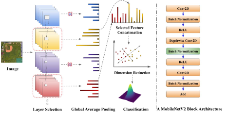
Our proposed approach, ReLU-Based Feature Fusion (RBFF), involves stacking features extracted from batch normalization layers of a few selected blocks based on a layer significance value from the lightweight MobileNetV2 [sandler2018mobilenetv2] model pretrained on ImageNet [imagenet_cvpr09] dataset. A block of MobileNetV2 with the proposed pipeline is depicted in Figure 1.
Before concatenating the extracted features, we use the global context of the features which helps reducing the dimension of the feature maps without eliminating the global context of the features. We further compress the features using dimension reduction techniques such as Principal Component Analysis (PCA) [wold1987principal] and Linear Discriminant Analysis (LDA) [lachenbruch1979discriminant] so that we get a more compact low-dimensional feature space without major loss of information. Finally, we use a one-vs-rest support vector machine (SVM) model on the compressed feature space for classification of the aerial images. The cost-effectiveness of our proposed model is two-fold. The model is space-efficient as its size is very small compared to the deep learning models that have been proposed so far for the task of remote scene classification ( MB). Furthermore, we investigate the accuracy vs model size trade-off issue as our technique employs two dimension reduction techniques in the pipeline, which comes with additional overhead in terms of the overall model size.
2 Background and Motivation
We have used pretrained lightweight MobilenetV2 model to extract the deep features through a layer selection strategy (RBFF), Whereas in [cao2020self], a nonparametric self-attention layer is proposed to get the more discriminative features from the pretrained CNN model (VGG-VD16 [krizhevsky2012imagenet] and AlexNet [simonyan2014very]). In [cheng2018deep], novel loss function was proposed so that the feature space of the deep learning model learned on the objective would discern between images representing separate classes, so that features of the images belonging to the same class would be mapped closer in the learned feature space and vice-versa for images belonging to different classes. Meanwhile, in [anwer2018binary], texture information of images obtained using Local Binary Pattern (LBP) was used in addition to traditional RGB images for training deep learning models. On the contrary, in [bi2020radc], a novel network architecture was proposed for aerial image classification, that consisted of dense blocks with addition and modification of residual attention layers and a classification layer. The network was designed to contain fewer parameters than the traditional models. Traditional VGGNet architecture was modified in [guo2019global] to incorporate local and global attention layers in order to capture the corresponding information from aerial images, along with subsidiary objectives added to the loss function for additional supervision.
Contrary to all these approaches, our proposed method is free from the huge overhead of deep learning model training. To classify aerial images, we follow a layer selection based transfer learning based approach where we apply a novel technique to select the most informative layers from a pretrained model.
3 Methods
3.1 ReLU-Based Feature Fusion
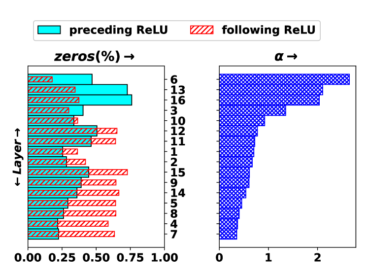
The most trivial approach can be the extraction of features from each layer which will result in accumulating a large number of features for a single image. Hence, rather than extracting features from each layer, we intuitively choose a subset of layers from the MobileNetV2 architecture for feature extraction. In MobileNetV2 [sandler2018mobilenetv2], each block architecture is of ReLU Conv BN ReLU like fashion. There are of such blocks in MobileNetV2. One such block is depicted in Figure 1. The BN layer within a block is surrounded by two ReLU layers in the same block, which are referred to as preceding and following ReLU layers respectively with respect to that BN layer. The ReLU layers are activation layers that replace its input to . The ratio of the fraction of zeros in the preceding and following ReLU layers around a BN layer designates the degree of significance of the BN layer in a given block. We denote this significance by for each block. More formally, the layer significance, , per block is defined as:
where and denote the average zero volume percentage of the preceding and the following ReLU layers of a BN layer, respectively. By zero volume, we mean how many zero elements exist in the output after a ReLU layer. If i.e. , the corresponding BN layer is more informative and vice versa. For an output tensor of ReLU layer, , where , , and refers to height, width, and channels of the feature map, we compute positive volume percentage of layer for each input image being fed to the network. So, is the zero volume percentage of a layer. To ensure minimal training, we randomly take images from each class, calculate of the layer for each image, and average them to get the general view of the layer. In this way, we compute the for a given layer. The average positive volume of a layer is reciprocal to the average percent of zeros in a layer in terms of . Conceptually, measures the importance of a batch normalization layer of each block. The higher the value of is, the more important the batch normalization layer is in terms of its suitability to be included in the feature extraction. Consequently, we stack features from top BN layers that have higher values. Figure 2 shows the significance of BN layers for all blocks of MobilenetV2 for AID dataset. The layers are sorted with respect to higher value of . We observe from the figure that, the top discriminative blocks are , , , and (the blocks with higher values for their respective BN layers).
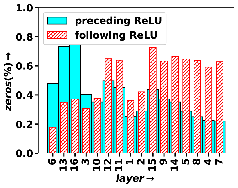
Similar characteristic is also identified for NWPU and UCM dataset in Figure 3.
Based on the values, we stack features from the BN layers of blocks 3, 6, 13, and 16 of MobileNetV2 (these are the blocks that have the largest values). To extract the global context information of the features from the selected layers, we apply the global attention based feature extraction.

The global average pooling (GAP) [lin2013network] is used to achieve this. For a channel of layer feature map, the global average pooling will be,
| (1) |
For each channel the 2-D feature map is converted to one value. Thus, global average pooling captures the global information of each channel of a layer output by converting 3-D tensor to a series of vector. By this way, a global attention based feature map is achieved.
3.2 Batch Normalization Layer in the Context of LDA
Batch normalization repeatedly enforces the activations to have zero mean and unit standard deviation [bjorck2018understanding], leading to faster and optimal convergence of the neural network training. In our approach, we use this fact to our advantage. Prior to the SVM classification, we use LDA for dimension reduction. Since LDA works best for normally distributed data, our choice of using the feature maps from the BN layers leads to the optimal performance of LDA and hence the optimal classification of the aerial images.
4 Results
4.1 Datasets
Dataset Number of Classes Number of Samples per Class UCM 21 100 AID 30 220-400 NWPU 45 700
In this paper, we have used three widely used aerial scene datasets, namely UCM [yang2012geographic], AID [xia2017aid], NWPU [cheng2017remote] The description of these datasets in terms of the number of classes and the number of samples per class is listed in Table 1.