Certifying Emergency Landing for Safe Urban UAV
††thanks: Our work has benefited from the AI Interdisciplinary Institute ANITI. ANITI is funded by the French ”Investing for the Future – PIA3” program under the Grant agreement n°ANR-19-PI3A-0004.
Abstract
Unmanned Aerial Vehicles (UAVs) have the potential to be used for many applications in urban environments. However, allowing UAVs to fly above densely populated areas raises concerns regarding safety. One of the main safety issues is the possibility for a failure to cause the loss of navigation capabilities, which can result in the UAV falling/landing in hazardous areas such as busy roads, where it can cause fatal accidents. Current standards, such as the SORA published in 2019, do not consider applicable mitigation techniques to handle this kind of hazardous situations. Consequently, certifying UAV urban operations implies to demonstrate very high levels of integrity, which results in prohibitive development costs. To address this issue, this paper explores the concept of Emergency Landing (EL). A safety analysis is conducted on an urban UAV case study, and requirements are proposed to enable the integration of EL as an acceptable mitigation mean in the SORA. Based on these requirements, an EL implementation was developed, together with a runtime monitoring architecture to enhance confidence in the system. Preliminary qualitative results are presented and the monitor seem to be able to detect errors of the EL system effectively.
Index Terms:
UAV Emergency Landing; Certification; Runtime Monitoring; Semantic Segmentation; SafetyI Introduction
The range of usage of Unmanned Aerial Vehicles (UAV) is growing rapidly and includes many application domains with positive impact for society such as agriculture, construction, structures visual inspection, live events filming, or delivery of medical equipment [1, 2]. However, their use in urban environment is still limited by technical and operational challenges related to societal acceptance and safety. As explained in [1], the primary risks for UAVs in urban environments are collision with other flying systems operating at low altitudes (air risk) and impact with third party below and adjacent to the area of operation (ground risk).
In most developed countries, an operation conducted by UAV can only be authorized when it is approved by a regulatory administration (e.g., EASA [3], FAA [4]). In particular, the Joint Authorities for Rulemaking of Unmanned Systems (JARUS) recently released a document called Specific Operations Risk Assessment (SORA) [5] to present official guidelines for the development of UAV operations that can be authorized by competent authorities. The SORA presents a detailed procedure to evaluate the risks of a specific UAV operation, as well as potential actions to mitigate these risks and precise conditions under which the operation can be authorized. The guidelines for certification are usually to keep the UAV far from people, properties and surrounding aircraft traffic to reduce risk if a critical failure occurs. For urban environments, this separation cannot be achieved and intensive risk analysis must be conducted to demonstrate that the UAV flight safety is acceptable for such high risk environment. In practice, this process is very demanding and most civil UAV urban operations cannot be authorized.
Regarding the ground risk, several Emergency Landing (EL) methods have been proposed to reduce the risk to people, infrastructures and the UAV itself [6, 7, 8]. As a general definition, EL aims at leveraging available information (on-board sensors, external databases) to select an area where the UAV can land safely, and to reach this landing zone in a potentially degraded control mode. Nevertheless, to this day, despite the noteworthy advances in this field of research, the precise requirements for EL are still unclear and no consensus is emerging about safety objectives. Because of this lack of well defined requirements, EL is still not considered as a valid mitigation to lower the ground risk in the SORA, and thus cannot be leveraged to ease the certification process of UAV urban operations.
The first contribution of this work consists in studying a specific use case called MediDelivery, to show that the current state of the SORA has limitations when applied to urban operations. The second contribution is to propose a set of safety requirements for EL, which could be used within the SORA to evaluate an EL module as a valid mitigation, thus easing the certification process of urban operations. Finally, we show that successful EL implementations must rely on complex computer vision functions, often based on deep learning, on which it is difficult to obtain safety guarantees. Hence, to comply with the proposed mitigation requirements, new advanced runtime monitoring techniques must be developed to ensure safety. The final contribution of this work is to propose such an implementation of EL, using semantic segmentation to identify landing zones and Bayesian neural network theory to monitor the predictions of the EL system at runtime. Primary qualitative results on the proposed solution are presented and show that our approach is promising and is worth further investigations.
II Background
II-A Certifying UAV operations
As for manned aviation, a European regulation (namely the EU 2019/947 and 2019/945 [9]) has been published by the European Union Aviation Agency (EASA) for UAVs. This regulation provides an implementation of rules and procedures to which applicant must demonstrate its compliance to obtain a flight authorization. Due to the variety of drones (ranging from toys to aircraft-like drones) and operations (e.g. infrastructure monitoring v.s. crowd surveillance) the severity of the possible outcomes of a UAV failure may be drastically different. This is why the regulation considers three categories of UAV operations:
- Open
-
light UAVs operating at a safe distance from people. These operations are not subject to any prior flight authorization due to minor severity of their failure.
- Specific
-
heavier UAVs operating nearby populated areas. These operations are subject to prior flight authorization and conduct of a Specific Operation Risk Assessment (SORA) [5].
- Certified
-
heaviest UAVs operating over assemblies of people or transporting people or dangerous goods. These operations are subject to manned aircraft like certification rules.
An important part of operations involving medium endurance drone, typically used for short-range delivery, falls into the specific category. The certification objectives for these operations are identified by applying the SORA. This document can be seen as a tailoring guide used by the applicant to identify:
-
1.
The level of on-ground and mid-air collision risks of the operation, called ground risk class (denoted GRC) ranging from 1 (low risk) to 8 (high risk) and air risk class (denoted ARC) ranging from A (low risk) to D (high risk). The computation of the intrinsic GRC and initial ARC are based on the UAV specifications, the operational scenario and the characteristics of the airspace.
-
2.
The suitable mitigation means and an estimation of their risk reduction. The implementation of appropriate mitigation strategies can be used to decrease the GRC and ARC. For GRC, three mitigation types are identified by the SORA:
-
•
M1 - Strategic mitigation: intends to reduce the number of people at risk on the ground by ensuring that the UAV remains far from high risk areas. It is achieved through preliminary studies to show that few people are present in a predefined ground safety buffer throughout the trajectory.
-
•
M2 - Reduction of ground impact effects: intends to reduce the effect of the UAV impact dynamics (i.e., area, energy, impulse, transfer energy, etc.). One example would be to open a parachute.
-
•
M3 - Emergency Response Plan (ERP): should be defined in the event of loss of control of the operation.
-
•
-
3.
The final level of safety required for the operation with respect to the final GRC/ARC. In the SORA, this level is called the Specific Assurance and Integrity Level (SAIL).
-
4.
The applicable operational safety requirements (called OSOs) and the expected level of compliance demonstration (called Robustness) commensurate to the SAIL.
With the current version of the SORA, it is very hard to certify UAV urban operations, mostly because the proposed mitigation strategies do not apply in densely populated environments (see Section III). For such highly complex environments, new active and intelligent mitigation means are required. A promising approach to reduce the number of people at risk on the ground is to select actively appropriate areas for landing, this kind of methods are called Emergency Landing (EL).
II-B Emergency Landing (EL)
Several recent research have studied the problem of EL, most of which focus specifically on Landing Zone Selection (LZS). The existing methods to LZS can be divided into three main categories:
II-B1 LZS from public databases
Interesting works have proposed to leverage knowledge from both static and dynamic external databases to select EL sites without infrastructures and with few people at risk. The model proposed in [10] uses publicly available maps to minimize the risk to humans (far from buildings), to properties (far from power lines and transportation ways) as well as to the UAV itself (terrain slope and roughness, water). In [6], the risk associated to EL is refined using dynamic cellphone usage data and takes the time of the day into consideration.
II-B2 LZS from on-board camera at high altitude
The second kind of approaches to LZS consists in using images from on-board camera at high altitude. The method presented in [11], applies a Canny edge detector on images recorded at high altitude and selects areas with lower concentration of edges for landing. This approach is improved in [12] by applying a Support Vector Machine (SVM) to classify the selected landing zones into building, bitumen, trees, grass or water. In [8], a Convolutional Neural Network (CNN) is trained to estimate depth from RGB images while simultaneously selecting a flat surface for safe landing. In practice, the LZ selected often ends up being flat roof-tops, roads or grass areas. Another common practice for recognizing different landing surfaces is to split the entire image into small tiles, which are classified into different categories. In [13], tiles are classified into one of water, trees, grass, bitumen or building categories, while in [14], small image patches are manually labeled as safe, not recommended or unsafe and a CNN is trained to predict the suitability of regions in the image for landing.
II-B3 LZS from on-board camera at low altitude
Finally, the last family of methods uses images recorded on-board at low altitude. In [15], a method using a SVM classifier on Gabor features is presented to distinguish between grass/soil, tree and inland water from UAV images. Regarding LZS, the authors claim that grass should be preferred for landing to avoid damaging or losing the UAV. In [16], information from lidar and binocular camera is fused to identify flat and safe ground areas for landing. Similarly, the method proposed in [17], simultaneously detects a landmark and evaluate its eligibility for landing if there is no obstacles. As the detections from these two papers are conducted from low altitude, they can evaluate the real-time availability of landing spots, and select the right time for landing. Finally, the algorithm proposed in [18] evaluates terrain flatness, steepness, depth accuracy and energy consumption to select a landing spot from low altitude.
II-B4 Limitations of current approaches
This literature review reveals the lack of unified goals definition for EL. Although the general objective is to avoid hurting people, infrastructures and the UAV, the precise way to achieve it differs among different works. Indeed, while some studies consider flat areas, such as roads, as safe for landing [8, 19], others specifically try to avoid transportation infrastructures [10]. One of the objectives of this paper is to propose unified objectives and requirements for EL algorithms, grounded on extensive safety considerations.
III Certifying UAV urban operations
In this section, the process proposed in the current version of the SORA [5] is applied to a specific use case to demonstrate the difficulty to certify UAV urban operations.
III-A The MediDelivery case study
The use case considered in this paper is called MediDelivery. It consists in using a UAV to deliver small automatic emergency equipment (e.g., defibrillator). It aims to shorten the intervention delay in cities. The UAV evolves in a complex airspace that may contain static obstacles (buildings, power lines, etc) and moving obstacles (other aircrafts).
MediDelivery is a rotary wing UAV with a span of around one meter. It flies at a height around 120 meters, leading to a typical ballistic vertical speed of . Combining this with a Maximum Take-Off Weight (MTOW) of yields a kinetic energy of . MediDelivery flies above populated areas and goes Beyond Visual Line Of Sight (BVLOS).
III-B Preliminary hazard analysis
In [20], Belcastro et al. proposed a comprehensive hazard analysis for generic civilian UAV operations. They study past accidents and conduct hazard analysis on various use cases to come up with fourteen main hazard categories such as loss of control, fly-away, lost communication, etc. The potential outcomes of these hazards can be divided into the two main risk categories proposed in the SORA: ground risks (GRC) and air risks (ARC). In this section, the hazard analysis from [20] is extended by conducting a severity analysis of hazardous outcomes related to ground risk. For each of the potential hazardous outcomes, we define severity levels (Table I). Due to space limitations the whole analysis is not presented, but the different outcomes and their associated severity are reported in Table II.
| Rating | Description |
|---|---|
| 1 | Negligible - No effect |
| 2 | Minor - Slight injury or damage to the drone |
| 3 | Serious - Important injury or damage to critical infrastructures, environment |
| 4 | Major - Single fatal injury |
| 5 | Catastrophic - Multiple fatal injuries |
| ID | Hazardous outcomes | Severity |
|---|---|---|
| R1 | UAV causes accident involving ground vehicles | 5 |
| R2 | UAV injures people on ground | 4 |
| R3 | Post-crash fire that threatens wildlife and environment | 3 |
| R4 | UAV collides with infrastructure (Building, bridge, power lines / sub-station, etc.) | 3 |
| R5 | UAV crashes into parked ground vehicle | 2 |
III-C Intended safety architecture
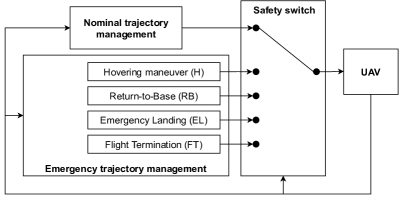
Following the hazard analysis, an architecture of the internal functions of the UAV is proposed in Figure 1. It has been designed as a continuous monitoring loop analyzing acquisition data to trigger the suitable emergency procedure when a critical anomaly is detected. The safety strategy can be described in more details as follows:
-
•
If the UAV faces a temporary unavailability of external services, an Hovering maneuver (H) is applied.
-
•
If the UAV faces a permanent unavailability of communication services or on-board failures still allowing proper navigability, a Return-to-Base (RB) maneuver is applied.
-
•
If the UAV faces a loss of navigation capabilities still allowing proper trajectory control (mainly localization and communication loss), an autonomous Emergency Landing maneuver (EL) is applied.
-
•
If the UAV cannot ensure flight continuation or safe EL, then a Flight Termination maneuver (FT) is applied. In practice, it stops the engines and opens a parachute.
III-D Application of the SORA
We apply the SORA to MediDelivery in order to evaluate the risks (GRC and ARC) and to identify the required safety counter-measures (see Section II-A).
III-D1 Initial risks identification
The determination of the GRC is based on the span, the typical kinetic collision energy of the UAV and the population density of the evolution and emergency areas. Based on the elements presented in Section III-A, the resulting intrinsic GRC is 6. The determination of the ARC is based on the characteristics of the aeronautic space. Since the maximum flight level is below 500 ft in a populated area, the resulting initial ARC is ARC-c.
III-D2 Mitigation
We consider that MediDelivery is evolving within a dedicated corridor segregated from other UAV or manned aircraft airspace. Thus the mid-air collision avoidance is tied to the assurance of remaining inside this predefined corridor. In the remaining of this paper we do not consider specific Detect and Avoid mechanisms, hence the final ARC remains ARC-c.
Regarding ground risk, among the emergency procedures presented in Section III-C (Figure 1), H and RB are degraded control modes that should not lead to ground collision, and cannot be used as GRC mitigation strategies. The remaining of this section discusses the possibility to use one of the three predefined GRC mitigation types (see Section II-A) within MediDelivery.
- M1 - Strategic mitigation
-
For urban UAVs like MediDelivery, M1 mitigation, based on a low density ground buffer throughout the drone trajectory, cannot apply as the operation is not likely to be conducted entirely in low density area (busy roads, crowded areas).
- M2 - Reduction of ground impact effects
-
If we consider the hazardous situations presented in Table I, this strategy can reduce widely the risk to injure people directly (risk R2), decreasing the severity of an impact from 4 to 2. However, applying such M2 mitigation will not reduce the impact of the most severe outcomes, since a landing on a busy road (risk R1) could still cause fatal accidents. Hence, M2 cannot be considered sufficient to decrease the GRC for MediDelivery.
- M3 - Emergency Response Plan (ERP)
-
An ERP can be designed for the MediDelivery use case, however, to be able to decrease the GRC the ERP needs to significantly reduce the number of people at risk. As the major risk is almost immediate in case of an unwanted landing on a busy road, it is not possible to argue such a GRC lowering.
Hence, none of the mitigation solutions proposed in the current version of the SORA applies directly to MediDelivery. The final GRC is at least 6 (7 if no M3 with medium robustness is proposed).
III-D3 Final safety objectives for MediDelivery
By combining the residual ground and air risk classes, the final SAIL allocated to MediDelivery is 5 (6 if no M3 is proposed). Knowing that the SAIL ranges from 1 to 7, one can consider that MediDelivery is a high risk operation among the specific category. Thus all the OSOs are requested and most of them at a high level of integrity and assurance. As is, the safety objectives require a high integrity and availability of the overall system from the drone to the pilot. Demonstrating a conformance to these objectives may lead to prohibitive validation and verification costs. This illustration of the SORA application motivates the need to propose alternative mitigation means such as EL along with a rigorous demonstration of its risk reduction and assurance enabling the applicant to alleviate the objectives over the whole UAV.
IV Emergency Landing as a SORA mitigation
The objective of this section is to introduce safety requirements for EL, so that it could be used straightforwardly as a SORA mitigation. In the SORA, a mitigation mean comes with a robustness level, which is actually the combination of the severity reduction induced by the mitigation (called integrity in SORA) and the confidence in this reduction (called assurance in SORA). Hence to be able to include EL in the SORA, we need to define in which SORA mitigation category EL is falling, and which requirements can be expressed to determine integrity and assurance levels.
When a crash is imminent, the mitigation can lower the collision risk as follows: M1 mitigation reduces the number of people at risk by ensuring that the drone will remain in a sparsely populated area, M2 mitigation limits the outcomes of the collision, and M3 mitigation reduces the people at risk by signaling the crash (e.g., evacuation of the area). Among the three mitigation categories, EL is closest to M1 as it intends to reduce the number of people at risks by identifying a safe landing zone. However, the SORA does not consider that safe landing zones can be actively identified from live data. Hence, we propose an adaptation of the M1 requirements for active-M1 mitigation techniques like EL.
IV-A SORA integrity level for EL
| Level | Existing SORA criteria for M1 (Annex B of [5]) | Proposed new criteria for EL (active-M1) |
|---|---|---|
| Low | 1. A ground risk buffer with at least a 1 to 1 rule. 2. The applicant evaluates the area of operations by means of on-site inspections/appraisals to justify lowering the density of people at risk. | 1. The selected landing zones do not contain high risk areas111Certain high risk areas (e.g., occupied by people) can be used if a provably efficient mitigation is in place for the hazards involved (e.g., parachute). (As defined in Table I). 2. The method is effective under the conditions of the operation (specific city, flight altitude, time of the day, season, etc.). |
| Medium | 1. Ground risk buffer takes into account: • Improbable single malfunctions or failures, • Meteorological conditions (e.g., wind), • UAV latencies, behavior and performance. • UAV behavior when activating measure, • UAV performance. 2. The applicant uses authoritative density data relevant for the area and time of operation. | 1. Landing zone selection takes into account222Selected landing zone should be far enough from hazardous areas to guarantee that adverse conditions will not lead the UAV to hazardous situations.: • Improbable single malfunctions or failures, • Meteorological conditions (e.g., wind), • UAV latencies, behavior and performance. • UAV behavior when activating measure, • UAV performance. |
| High | Same as Medium | Same as Medium |
In Table II, we have identified that the most severe potential outcome of a UAV urban landing is to land on a busy road. Indeed, for all types of landing (parachute, controlled landing, crash), a UAV reaching the ground on a busy road can always result in an accident with multiple fatalities. The second outcome that can cause death is when the UAV lands on people. However, this risk can be mitigated using an effective M2 mitigation to reduce the effects of the impact.
Hence, to claim any severity reduction, i.e., a low integrity in the SORA parlance, an EL module should avoid roads at all costs, and should prevent the UAV from landing on populated areas without an efficient mechanism to reduce the kinetic energy of the UAV. Additionally to claim a minimal integrity, the geometry of the selected landing zone should take into account the conditions of operation that may influence the deviation during the landing maneuver (potentially performed by a parachute). For example, if the UAV lands with parachute opened at a given altitude, the buffer from roads must take into account the typical parachute drift in nominal conditions.
As proposed for the initial M1, any higher integrity level can be achieved by taking into account adversary conditions and failures in the landing zone definition. The proposed integrity requirements for EL are summarized in Table III. For comparison, the corresponding criteria for M1 mitigation are also reported.
IV-B SORA assurance level for EL
| Level | Existing SORA criteria for M1 (Annex B of [5]) | Proposed new criteria for EL (active-M1) |
|---|---|---|
| Low | 1. The applicant declares that the required level of integrity is achieved. | 1. The applicant declares that the required level of integrity is achieved. |
| Medium | 1. Supporting evidence to claim the required level of integrity has been achieved (testing, analysis, simulation, inspection, design review, experience). 2. The density data used is an average density map for the date/time of the operation from a static sourcing (verified by applicable authority). | 1. Supporting evidence to claim the required level of integrity has been achieved (testing on public datasets, testing in context333To ensure safety, real world tests can be realized by conducting pre-flights with a small UAV, containing the same camera as the real system.). 2. The video data used for in-context testing are recorded and verified by applicable authority. 3. Safety monitoring techniques are in place to ensure proper behavior of any function relying on complex computer vision or machine learning. |
| High | 1. The claimed level of integrity is validated by a competent third party. 2. The density data used is a near-real time density map from a dynamic sourcing and applicable for the date/time of the operation. | 1. The claimed level of integrity is validated by a competent third party. 2. The method was extensively validated under a wide range of external conditions (lighting, weather). |
The assurance requirement of the Table IV explains how the confidence in a mitigation is commensurate to the conducted validation and verification activities.
As for M1, the minimal level of assurance is achieved by a simple declaration of the applicant. As shown in Section II-B, LZS relies on complex computer vision functions, on which it is difficult to provide a rigorous specification of the expected behavior of the learned model. This way, traditional safety assurance practices conducted during the design process are not sufficient to ensure safe behavior of the EL system [21]. Hence to claim a higher level of assurance, the applicant must justify that safety monitoring techniques checking the outputs of the LZS model at runtime has been designed. Moreover the applicant must guarantee that both the main system and the monitor are working as expected, tests must be conducted in the specific context of the operation. The applicant should also validate his approach under different external conditions in order to know the validity domain of the proposed algorithm. Finally, for high assurance, all tests should be designed and validated jointly with a competent third party.
V EL implementation proposal
To comply with the EL integrity requirements from Table III, a possible two step implementation of EL is:
-
1.
Select an area far from busy roads.
-
2.
Go to this area and open a parachute.
Indeed, from what was seen above (Table I), if this algorithm is implemented successfully with good assurance, no fatality should occur. In this section, we focus on the landing zone selection module, and a Busy Road Detection (BRD) system is presented. To comply with the assurance requirements of the Table IV, we also propose a new approach to monitor the behavior of the BRD model at runtime in order to increase confidence in its predictions, as well as the associated safety architecture for integration.
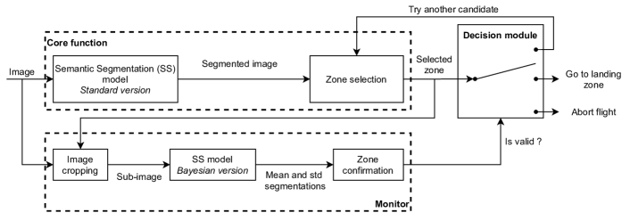
V-A Landing zone selection architecture
The general architecture proposed for landing zone selection is shown in Figure 2 is derived from the typical Computer/Monitor safety pattern. It is composed of the core function, which selects a landing zone candidate from an input image, and the monitor, verifying that this candidate is safe. Then, the Decision Module (DM) is in charge of deciding what actions to take. If the monitor confirms the proposed zone, then the DM will trigger landing execution. If the zone is rejected by the monitor, the DM will either request a new trial or abort the flight if an additional trial cannot be safely performed. The core function intends to address Low and Medium Integrity requirements (Table III), whereas the monitor deals with the Medium-3 assurance requirement (Table IV).
V-B Implementation details
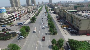
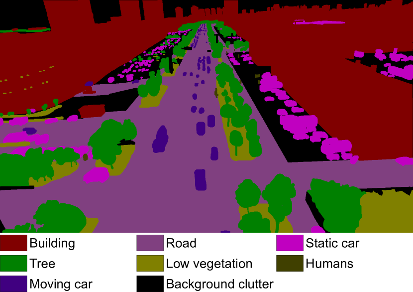
The core function is based on semantic segmentation, which consists in assigning a label from a set of predefined categories to each pixel of an image [23]. In particular, here we aim at building a semantic segmentation model able to determine if a given pixel is part of a busy road or not. To do this, we use a model called Multi-Scale-Dilation net (MSDnet), proposed in [22]. It was trained on the UAVid dataset, which is composed of 300 high-resolution images captured from a UAV, in slanted views. UAVid images are densely labeled for semantic segmentation with 8 classes (Figure 3). From this dataset, we cannot explicitly detect busy roads, instead we consider that all pixel corresponding to road and cars should be avoided. Then, for a given on-board image, the EL system can use the predicted segmentation to identify areas far from busy roads, to which the UAV can navigate and terminate the flight by opening its parachute. However, as most successful semantic segmentation models, MSDnet was trained using machine learning, and it is hard to obtain strong guarantees about its robustness. For instance, it tends to make mistakes on out-of-distribution data, as illustrated by the left image in Figure 4(b). This image was extracted from a drone footage that does not belong to the UAVid dataset, and which presents challenging lighting conditions as it was taken at sunset. To address this issue, we propose to monitor the predictions using the model’s self uncertainty.
However, like most deep learning models, MSDnet produces point-estimates as outputs and knowledge about the confidence of the model in its predictions is unknown [24]. In other words, for an image , a given pixel and a given category , the score obtained after the softmax layer of the model does not represent the confidence of the network that belongs to . Basically, from a standard neural network, the only relevant information that can be extracted from the final softmax scores is the predicted class :
| (1) |
A possible solution to compute uncertainty in the predictions of MSDnet is to use a Bayesian version of the same model [25]. In practice, we use the Monte Carlo dropout method to convert the standard MSDnet model into a Bayesian one (BMSDnet) [25]. It consists in maintaining the dropout layers active at inference time444In practice, we use a dropout rate of 0.5 for all relevant MSDnet layers, which can be shown to be mathematically equivalent to an approximation to the probabilistic deep Gaussian process [26]. To obtain uncertainty from this simple Bayesian MSDnet, the input image must be processed several times. As different neurons are dropped each time, each inference results in different predictions. Then, for each pixel and each category , we can compute both the empirical mean and standard deviation of the different values of predicted by BMSDnet. The standard deviation is a good proxy for MSDnet uncertainty regarding the fact that belongs to class . The intuition behind this approach is that a neural network trained with dropouts has redundant connections for its highly certain predictions, making them less impacted by the removal of some neurons.
Finally, EL is intended to serve as a critical safety function, thus classifying a busy road to another category can lead to catastrophic outcomes. Hence, the monitor is designed to be conservative by over-approximating the road category. To do so, once we have access to the probability distribution for a given pixel, the 99.7% confidence interval of the predictions can be computed and tested against a small decision threshold . Hence, is considered safe (i.e., it does not belong to the road category) if and only if it verifies
| (2) |
We note that in Equation 2, the index related to category was dropped as we only consider the busy road category. As UAVid is composed of 8 categories, we choose in order to make sure that the road score is lower than a random guess. In practice, Equation 2 must be verified for the three UAVid categories that make up the busy road category.
In practice, running Bayesian inference with MSDnet on such large images (3840x2160) is prohibitively slow as it requires to run the model several times. Indeed, EL is a critical function that must run fast in case of an emergency. In addition, the embedded computing power for medium size UAVs is often limited. This important constraint justify the selected monitoring architecture presented in Figure 2, where a candidate landing zones is pre-selected using the standard MSDnet, and only smaller sub-images are passed to the monitor in order to verify the proposals before triggering landing execution. Our first experiments using a Nvidia Quadro P5000 GPU showed that if prediction statistics are computed on 10 samples, the monitor verifies a 1024x1024 image in less than 5 seconds, whereas it takes over a minute for the full image.
V-C First results
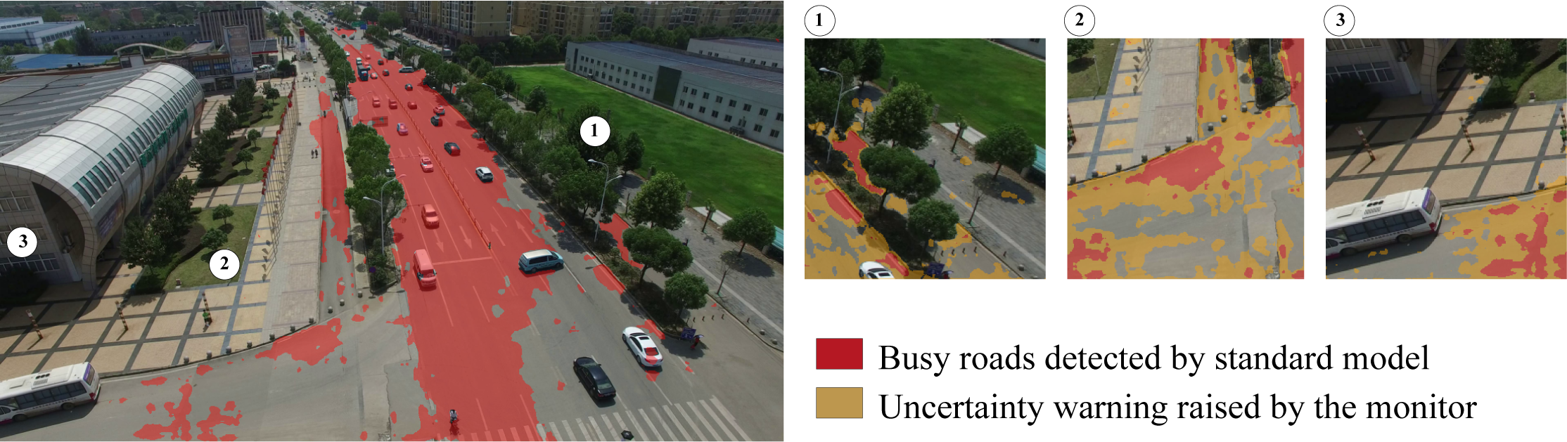
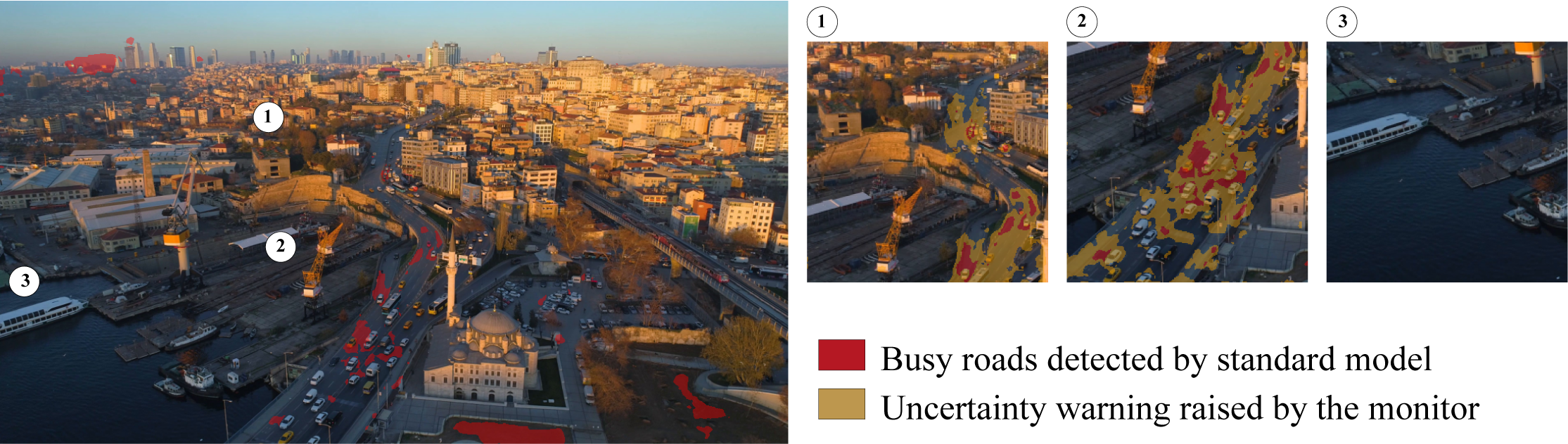
Preliminary experiments were conducted to evaluate qualitatively the proposed approach for road detection and runtime monitoring. Two example images can be seen in Figures 4. In Figure 4(a), an image from the test set of UAVid was segmented using MSDnet (left), this image should be part of the test set to comply with requirements Medium-1, from the Assurance table (Table IV). Then, three sub-images containing areas with and without roads were selected manually to illustrate the behavior of the monitor. They are shown on the right and their top left corners are localized on the main image for ease of readability. The second image tested (Figure 4(b) was collected online and does not belong to UAVid, it could be used for proving the High-2 Assurance item. It represents very harsh conditions for our approach as the altitude of the drone is different from UAVid images and the image was taken at sunset, involving complex lighting conditions.
The proposed MSDnet seems to perform reasonably well on the image from UAVid, but it clearly fails on the out-of-distribution image. However, the monitor seems to be able to trigger an uncertainty warnings for a large part of the road areas that was not covered by the core model. We also note that no warning is raised for Figure 4(b)-3, as expected.
VI Conclusion
In this work, we demonstrated through a case study that it is currently very hard to certify UAV operations in densely populated areas due to the lack of acceptable mitigation means in the SORA. Emergency landing, which selects landing zones actively using data from on-board cameras, appears to be a promising research direction to help solve this problem. Hence, a second contribution was to define a set of requirements consistent with SORA, so that EL could be considered as an applicable mitigation mean. Finally, we proposed an implementation of landing zone selection based on semantic segmentation, as well as a safety architecture to monitor machine learning components at runtime to comply with the proposed requirements. The first results illustrate the monitor capability to discard large road areas unseen by the model.
In future work, the preliminary results presented here should be complemented by a formal quantitative study to ensure compliance with the identified Assurance requirements. In addition, many regions containing roads are missed by the monitor. Hence, it will be worth investigating other segmentation models, including lightweight ones in order to be able to run on on-board GPUs. Training on other datasets and using other uncertainty estimation techniques could also be investigated in future research. Finally, hybrid methods combining learning-based techniques with using public databases could be envisioned to improve emergency landing.
References
- [1] S. Watkins, J. Burry, A. Mohamed, M. Marino, S. Prudden, A. Fisher, N. Kloet, T. Jakobi, and R. Clothier, “Ten questions concerning the use of drones in urban environments,” Building and Environment, vol. 167, p. 106458, 2020.
- [2] S. Bhattarai, K. Poudel, N. Bhatta, S. Mahat, S. Bhattarai, and K. S. Thapa Magar, “Modeling and development of baseline guidance navigation and control system for medical delivery UAV,” in 2018 AIAA Information Systems-AIAA Infotech@ Aerospace, 2018, p. 0508.
- [3] European Aviation Safety Agency (EASA), “Introduction of a regulatory framework for the operation of unmanned aircraft systems in the “open” and “specific” categories,” European Aviation Safety Agency (EASA), Opinion N0 01/2018, 2018.
- [4] Federal Aviation Administration (FAA), “Part 107 — small unmanned aircraft systems,” Federal Aviation Administration (FAA), Rules and guidelines, 2016.
- [5] Joint Authorities for Rulemaking of Unmanned Systems (JARUS), “JARUS guidelines on Specific Operations Risk Assessment (SORA) v2.0,” Guidelines, 2019.
- [6] P. F. Di Donato and E. M. Atkins, “Evaluating risk to people and property for aircraft emergency landing planning,” Journal of Aerospace Information Systems, vol. 14, no. 5, pp. 259–278, 2017.
- [7] L. Mejias, D. L. Fitzgerald, P. C. Eng, and L. Xi, “Forced landing technologies for unmanned aerial vehicles: towards safer operations,” Aerial vehicles, vol. 1, pp. 415–442, 2009.
- [8] A. Marcu, D. Costea, V. Licaret, M. Pîrvu, E. Slusanschi, and M. Leordeanu, “SafeUAV: Learning to estimate depth and safe landing areas for uavs from synthetic data,” in Proceedings of the European Conference on Computer Vision (ECCV) Workshops, 2018, pp. 0–0.
- [9] European Union Aviation Safety Agency (EASA), “Easy access rules for unmanned aircraft systems (regulations (eu) 2019/947 and (eu) 19/945),” European Union Aviation Safety Agency (EASA), Regulation, 2020.
- [10] M. Bleier, F. Settele, M. Krauss, A. Knoll, and K. Schilling, “Risk assessment of flight paths for automatic emergency parachute deployment in UAVs,” IFAC-PapersOnLine, vol. 48, no. 9, pp. 180–185, 2015.
- [11] L. Mejias and D. Fitzgerald, “A multi-layered approach for site detection in UAS emergency landing scenarios using geometry-based image segmentation,” in 2013 International Conference on Unmanned Aircraft Systems (ICUAS). IEEE, 2013, pp. 366–372.
- [12] L. Mejias, “Classifying natural aerial scenery for autonomous aircraft emergency landing,” in 2014 International Conference on Unmanned Aircraft Systems (ICUAS). IEEE, 2014, pp. 1236–1242.
- [13] K. P. Lai, “A deep learning model for automatic image texture classification: Application to vision-based automatic aircraft landing,” Ph.D. dissertation, Queensland University of Technology, 2016.
- [14] I. Funahashi, Y. Umeki, T. Yoshida, and M. Iwahashi, “Safety-level estimation of aerial images based on convolutional neural network for emergency landing of unmanned aerial vehicle,” in 2018 Asia-Pacific Signal and Information Processing Association Annual Summit and Conference (APSIPA ASC). IEEE, 2018, pp. 886–890.
- [15] B. Ayhan and C. Kwan, “A comparative study of two approaches for UAV emergency landing site surface type estimation,” in IECON 2018-44th Annual Conference of the IEEE Industrial Electronics Society. IEEE, 2018, pp. 5589–5593.
- [16] L. Chen, X. Yuan, Y. Xiao, Y. Zhang, and J. Zhu, “Robust autonomous landing of UAV in non-cooperative environments based on dynamic time camera-LiDAR fusion,” arXiv preprint arXiv:2011.13761, 2020.
- [17] M.-F. R. Lee, A. Nugroho, T.-T. Le, S. N. Bastida et al., “Landing area recognition using deep learning for unammaned aerial vehicles,” in 2020 International Conference on Advanced Robotics and Intelligent Systems (ARIS). IEEE, 2020, pp. 1–6.
- [18] M. Mittal, R. Mohan, W. Burgard, and A. Valada, “Vision-based autonomous UAV navigation and landing for urban search and rescue,” arXiv preprint arXiv:1906.01304, 2019.
- [19] P. F. Di Donato and E. M. Atkins, “An off-runway emergency landing aid for a small aircraft experiencing loss of thrust,” in AIAA Infotech@ Aerospace, 2015, p. 1798.
- [20] C. M. Belcastro, R. L. Newman, J. Evans, D. H. Klyde, L. C. Barr, and E. Ancel, “Hazards identification and analysis for unmanned aircraft system operations,” in 17th AIAA Aviation Technology, Integration, and Operations Conference, 2017, p. 3269.
- [21] J. M. Faria, “Machine learning safety: An overview,” in Proceedings of the 26th Safety-Critical Systems Symposium, York, UK, 2018, pp. 6–8.
- [22] Y. Lyu, G. Vosselman, G.-S. Xia, A. Yilmaz, and M. Y. Yang, “Uavid: A semantic segmentation dataset for uav imagery,” ISPRS Journal of Photogrammetry and Remote Sensing, vol. 165, pp. 108–119, 2020.
- [23] S. Hao, Y. Zhou, and Y. Guo, “A brief survey on semantic segmentation with deep learning,” Neurocomputing, vol. 406, pp. 302–321, 2020.
- [24] E. Goan and C. Fookes, “Bayesian neural networks: An introduction and survey,” in Case Studies in Applied Bayesian Data Science. Springer, 2020, pp. 45–87.
- [25] J. Mukhoti and Y. Gal, “Evaluating bayesian deep learning methods for semantic segmentation,” arXiv preprint arXiv:1811.12709, 2018.
- [26] Y. Gal and Z. Ghahramani, “Dropout as a bayesian approximation: Representing model uncertainty in deep learning,” in international conference on machine learning. PMLR, 2016, pp. 1050–1059.