Omni-swarm: A Decentralized Omnidirectional Visual-Inertial-UWB State Estimation System for Aerial Swarms
Abstract
Decentralized state estimation is one of the most fundamental components of autonomous aerial swarm systems in GPS-denied areas yet it still remains a highly challenging research topic. Omni-swarm, a decentralized omnidirectional visual-inertial-UWB state estimation system for aerial swarms, is proposed in this paper to address this research niche. To solve the issues of observability, complicated initialization, insufficient accuracy, and lack of global consistency, we introduce an omnidirectional perception front-end in Omni-swarm. It consists of stereo wide-FoV cameras and ultra-wideband sensors, visual-inertial odometry, multi-drone map-based localization, and visual drone tracking algorithms. The measurements from the front-end are fused with graph-based optimization in the back-end. The proposed method achieves centimeter-level relative state estimation accuracy while guaranteeing global consistency in the aerial swarm, as evidenced by the experimental results. Moreover, supported by Omni-swarm, inter-drone collision avoidance can be accomplished without any external devices, demonstrating the potential of Omni-swarm as the foundation of autonomous aerial swarms.
Index Terms:
Swarms, aerial systems: perception and autonomy, multi-robot systems, sensor fusionI Introduction
For any aerial robotics system, the estimation of states, including positions and attitudes, is crucial. The estimation system lays a solid foundations for higher-level functions, such as path planning [zhou2019robust] and mapping [wang2019surfel]. The state estimation problems for single-drone systems are currently well-addressed through approaches such as visual-inertial odometry (VIO) [qin2018vins, murORB2, Geneva2020ICRA] and LiDAR odometry[zhang2014loam, lin2020loam]. However, when we look beyond a single-drone to multiple drones working as an aerial swarm, the problem becomes much more complicated. In a swarm, each drone needs to estimate its ego state and also obtain the relative poses of other drones.
To date, the vast majority of aerial swarm researchers have adopted external devices, such as motion capture systems [preiss2017crazyswarm], ultra-wideband (UWB) systems with anchors[ledergerber2015robot] and GPS [jaimes2008approach], and RTK-GPS[moon2016outdoor] systems, to provide state estimations, which significantly limits the application of aerial swarms in the real world. Although motion capture systems and UWB modules with anchors can work in indoor environments with decent accuracy, they are centralized systems and require bulky external devices, meaning that they are susceptible to losing the central devices and are challenging to deploy. A requirement of a practical swarm application is simple deployment, which such approaches typically fail to meet.
The decentralized scheme of swarm robots is becoming popular in swarm robotics research [petravcek2021large, smith2018distributed, petravcek2021large, zhu2021cooperative, zhu2021distributed, choudhary2017distributed, lajoie2020door] because of its significant advantages. A robot swarm with this scheme does not require all robots to have stable communication with a central computer, which makes it more flexible in real-world environments where communication is limited. Additionally, each robot can act largely independently from the remainder of the team, making the whole system more fault-tolerant to single-point failure. To build a fully autonomous decentralized multi-robot system (multi-aerial-robot swarm, also known as an aerial swarm), a key problem is how to achieve relative state estimation in a decentralized fashion. The primary motivation of this paper is to solve this fundamental problem with additional global consistency of the estimated states, laying a solid foundation for a decentralized aerial swarm.
Recently, researchers have started to develop approaches to perform decentralized relative state estimation on aerial swarms. One of the most straightforward ideas is to utilize visual object detection to detect the drones in the aerial swarm to estimate the relative state [xu2020decentralized, guo2017ultra, guo2019ultra, ziegler2021distributed]. Fusing distance measurements from the UWB and odometry (usually VIO) [xu2020decentralized, walter2019uvdar, nguyen2019vision, guo2017ultra, guo2019ultra, ziegler2021distributed] is another viable approach, along with estimating relative states from common environment features captured by the drones [piasco2016collaborative, achtelik2011collaborative] or extracting relative states from sparse maps built by the aerial swarms [cunningham2010ddf, cunningham2013ddf, choudhary2017distributed, lajoie2020door].
However, the practicability of these methods is limited by some serious issues, as follows,
-
1.
Observability issue caused by a restricted field of view (FoV). For visual-drone-detection-based methods[walter2019uvdar, nguyen2019vision, xu2020decentralized], the relative states are observable only when others drones are in the drone’s FoV.
-
2.
Complicated initialization. UWB-odometry fusion methods [guo2017ultra, guo2019ultra, xu2020decentralized, ziegler2021distributed] require large motions to initialize the system. The complex initialization procedure may cause severe safety issues and even crashes.
-
3.
Insufficient accuracy. The estimated position errors in previous works [guo2017ultra, guo2019ultra, ziegler2021distributed] are generally around 20 cm–50 cm, meaning that these swarm systems can scarcely be adopted for use in confined indoor spaces or close formation scenarios.
-
4.
Lack of global consistency. For all the current relative state estimation methods, the estimated poses drift and the ego state estimation cause consistency issues. Global consistency becomes especially important when we expect to build global maps based on state estimation.
To address the challenges, in this paper, we extend our previous method[xu2020decentralized] and propose Omni-swarm: a decentralized omnidirectional visual-inertial-UWB state estimation system for aerial swarms, which combines the advantages of the UWB-odometry fusion method[xu2020decentralized, walter2019uvdar, nguyen2019vision, guo2017ultra, guo2019ultra, ziegler2021distributed], visual-object-detection-based methods[walter2019uvdar, nguyen2019vision, xu2020decentralized], and map-based methods [piasco2016collaborative, achtelik2011collaborative, luqi2018collaborative, michael2014collaborative, choudhary2017distributed, lajoie2020door].
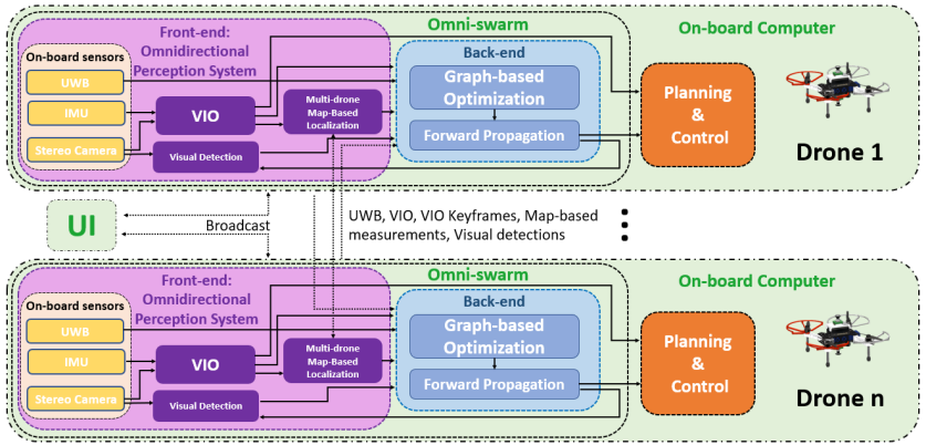
The most important contribution to address the aforementioned issues is the introduction of an omnidirectional perception front-end. The front-end includes the hardware capturing omnidirectional visual information and the algorithms processing this information. Specifically, we use two fisheye cameras with a wide-FoV (up to ) to achieve omnidirectional observation of the surrounding area. We develop VINS-Fisheye as the ego-motion estimator of the front-end, which is a VIO state estimator using the measurements from stereo wide-FoV fisheye cameras for ego-motion estimation. Multi-drone map-based localization (MDML) based on real-time-generated sparse maps is further introduced to ensure the global consistency of state estimation and to achieve fast initialization. Finally, a visual drone tracking module detects and tracks the other drones to provide accurate relative pose estimation of the tracked targets. In addition to omnidirectional visual information, we also use UWB sensors to measure the relative distance between drones. This measurement can also be considered as omnidirectional.
As the back-end of the state estimation, we adopt the graph-based optimization method, which fuses the measurements from the front-end in real-time to estimate the states of the swarm with high accuracy. In the back-end, we adopt the state-of-the-art outlier rejection method to reduce the errors from the front-end to achieve high-accuracy and robustness.
Omni-swarm is designed to be decentralized, it runs on each drone’s onboard computer individually instead of using a central server. Differing from previous work on relative-state estimation, which only work in a line-of-sight situation[xu2020decentralized, walter2019uvdar, guo2017ultra, guo2019ultra, ziegler2021distributed], Omni-swarm can estimate the state of the swarm when another drone is in non-line-of-sight if the same place has been visited. This capability is given by MDML. Another advantage over previous works [xu2020decentralized, walter2019uvdar, guo2017ultra, guo2019ultra, ziegler2021distributed] that MDML brings the global consistency; the long-term drifting of the ego state is eliminated by the map-based localization and thus guarantee global consistency of the estimation results. Omni-swarm also inherits the high accuracy of our previous work[xu2020decentralized], which has a high relative localization accuracy compared to other related works[walter2019uvdar, guo2017ultra, guo2019ultra, ziegler2021distributed].
In addition, the complex initialization problem is solved in Omni-swarm by introducing various system initialization methods, including map-based initialization and visual drone detection tracking initialization. Another Omni-swarm improvement that helps with practical applications is its plug-and-play feature, based on our newly introduced initialization methods, Omni-swarm allows the temporary joining or exiting of drones. Finally, Omni-swarm has redundancy in the information shared among the swarm and computations performed by the drones, which brings robustness to possible temporary signal loss and partial sensor failures.
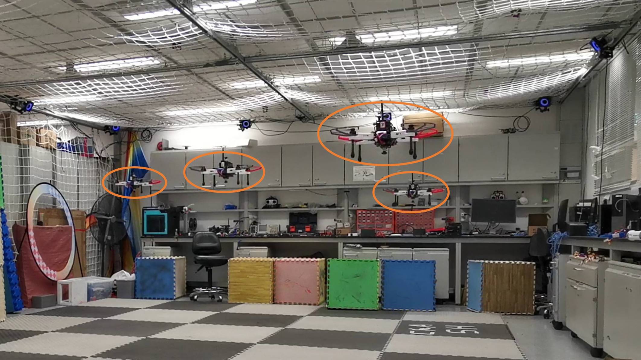
To verify the above features of Omni-swarm, we perform comprehensive experiments in simulation and real-world experiments. Moreover, we design an inter-drone collision avoidance experiment to verify Omni-swarm under realistic conditions. The main contributions of this paper are:
-
1.
Omni-swarm, a decentralized omnidirectional visual-inertial-UWB swarm state estimation system. Extensive experiments are conducted to validate Omni-swarm.
-
2.
Open-source releases of the software and the custom datasets have been made public111https://github.com/HKUST-Aerial-Robotics/Omni-swarm.
In our previous work [xu2020decentralized], we proposed a two-stage visual-inertial-UWB fusion method for relative state estimation. The method has the advantages of both visual-object-detection-based relative state estimation[walter2019uvdar, nguyen2019vision] and UWB-odometry fusion relative state estimation [guo2017ultra, guo2019ultra]. However, global consistency is absent. Also, the method still suffers from the same complicated initialization issue and the observability issue caused by the restricted FoV, as with other related methods. Although the previous method works in a non-line-of-sight case, the relative estimation accuracy will deteriorate. In extreme situations, the relative state can become unobservable. For example, drones fly parallelly side-by-side. In this paper, the initialization and global consistency issues are addressed by introducing multi-drone map-based localization, and the observability is fixed by using omnidirectional cameras.
In this paper, related works are discussed in Sect. II. Omni-swarm is briefly introduced in Sect. III, and a clear definition of the state estimation problem is defined in Sect.LABEL:subsec:def. The front-end of Omni-swarm is presented in Sect. LABEL:sect:front-end, while the back-end is introduced in Sect. LABEL:sect:back-end. Experimental results are discussed in Sect. LABEL:sect:experiment. Finally, we conclude the paper in Sect. LABEL:sect:con and introduce potential future works.
II Related Works
II-A Visual inertial odometry on Aerial Swarm
In order to overcome the state estimation issues in multiple environments, including GPS-denied areas, visual-inertial simultaneous localization and mapping (visual-inertial SLAM) [campos2021orb, mur2017visual, usenko2019visual] and visual-inertial odometry (VIO) [qin2018vins, Geneva2020ICRA, qin2019a, bloesch2015robust] are widely adopted on single drone systems. These visual inertial systems fuse the visual images and the inertial measurement unit (IMU) data together to estimate ego-motion without requiring external devices. Although VIO systems can be effortlessly adopted in various environments without cumbersome external devices and they are directly utilized by researchers on swarms for formation flights [weinstein2018visual, lusk2020distributed], the state estimations suffer from severe drift, which can be detrimental to multi-drone systems. Specifically, the different drifts of individual drones in an aerial swarm induce distinct position estimations at the same location, possibly causing fatal crashes in collaborative missions in the absence of other correction methods.
II-B Relative Swarm State Estimation
One of the most effective methods to compensate for the drift of VIO in aerial swarms is to incorporate the relative state estimation between the drones. The existing relative state estimation methods can generally be divided into the following three categories: 1) UWB-odometry fusion relative state estimation methods [guo2017ultra, guo2019ultra, xu2020decentralized, nguyen2019persistently, ziegler2021distributed], 2) visual-object-detection-based relative state estimation methods [walter2019uvdar, nguyen2019vision, xu2020decentralized], and 3) environment-feature-based relative state estimation methods [piasco2016collaborative, achtelik2011collaborative].
However, all of these methods have drawbacks in real application scenarios. The previous UWB-odometry based methods[guo2017ultra, guo2019ultra, ziegler2021distributed] fuse the ego-motion estimated by VIO and UWB distance measurements to achieve relative state estimation. These methods can only estimate relative localization in line-of-sight situations and provide merely a meter to decimeter level of accuracy. Even in line-of-sight situations, the relative localization can become unobservable in some cases, e.g., parallel flight tasks [nguyen2019distance]. Furthermore, the initialization requires a certain amount of motion, usually several meters. Both of these drawbacks substantially limit the practicability of the UWB-visual fusion methods in feature-rich narrow environments. A viable idea to address observability issue was proposed by Nguyen et al. [nguyen2019distance]. Briefly, a drone in the swarm keeps an irregular motion to guarantee observability of the relative state estimation, which may present safety issues and limit the aerial swarm’s cooperation. In Omni-swarm, the observability issue can be solved by visual drone tracking and map-based localization while the formation is flying. In addition, by introducing map-based localization, we can achieve fast initialization without motion.
Visual-object-detection-based methods [walter2019uvdar, nguyen2019vision, xu2020decentralized] are capable of delivering centimeter-level accuracy. However, the accuracy of these methods in a swarm of drones is highly dependent on the distance the drones are from each other. Data association from the detection results to the corresponding drone ID is also an issue when all the drones appear identical. A coupled-probabilistic-data-association-filter (CPDAF)-based approach is proposed in [nguyen2019vision] to associate the detection result and estimate the relative state. Nevertheless, the visibility requirement between the drones and the limited FoV of their cameras restrict the swarm formation and the distance between drones for stable state estimation. In this paper, the FoV issue is addressed by introducing an omnidirectional front-end. Due to the UWB measurements, the proposed method can still estimate the relative state when the distances between the drones are too far for them to detect each other.
Finally, all the aforementioned methods are limited to relative localization, and global consistency of the estimated states cannot be guaranteed. In this paper, global consistency is guaranteed by introducing map-based localization. This will also help us with global mapping in our future work.
II-C Environmental-Features-based Method and Collaborative Simultaneous Localization and Mapping
Environment-feature-based methods [piasco2016collaborative, achtelik2011collaborative] rely on multiple drones’ common environmental texture features to estimate the relative poses. The methods require sufficient overlapped features between the view of the drones, limiting the swarm formation and heading, while only working in feature-rich environments.
Collaborative simultaneous localization and mapping (CSLAM) methods [luqi2018collaborative, michael2014collaborative, cunningham2010ddf, cunningham2013ddf, choudhary2017distributed, lajoie2020door, zhu2021distributed, zhu2021cooperative] focus on sparse and dense mapping utilizing the sensors on the multi-robot system, and can estimate the states of aerial swarms. DDF-SAM [cunningham2010ddf, cunningham2013ddf] presents a landmark-based back-end implementation without providing the front-end and data association between features among the swarm. Choudhary et al. [choudhary2017distributed] utilized objects as landmarks, requiring known objects and their 3D models in the scene, which limits the method’s real-world practicability. DOOR-SLAM [lajoie2020door, luqi2018collaborative, michael2014collaborative] achieves localization of robots using VIO incorporating loop closure detection (also known as map-based localization in this paper). [luqi2018collaborative, michael2014collaborative, lajoie2020door, choudhary2017distributed] estimate the state with the pose graph optimization (PGO). However, the accuracy of relative localization is crucial for cooperation inside the aerial swarm, and this has not been featured in these papers. Generally speaking, the PGO methods are not accurate because they do not directly use the features for relative localization. Zhu et. al. [zhu2021distributed] propose a distributed visual-inertial fusion for cooperative localization and reach centimeter-level accuracy. In [zhu2021distributed] the environmental features are tightly coupled in the cooperative localization.
Due to the nature of map-based localization, the above CSLAM methods are limited to feature-rich environments and are also limited by the camera FoV. In this paper, with an omnidirectional front-end and UWB measurements, Omni-swarm will not be limited by the FoV and can still estimate relative state without rich common environmental features.
II-D Visual-inertial-UWB Fusion with Global Consistency
Some of the works mentioned as being UWB-odometry fusion [guo2019ultra, xu2020decentralized, ziegler2021distributed] can be considered to be visual-inertial-UWB fusion (also known as visual-inertial-range fusion, or VIR fusion). However, global consistency is absent in these works. Unlike these relative localization methods, a class of works [guo2019ultra, xu2020decentralized, ziegler2021distributed] uses VIR fusion to achieve global localization by placing a fixed UWB anchor in the environment. With the help of this anchor, these methods can effectively eliminate the drift of odometry. The drawback of these methods is that they require additional infrastructure to be placed on the ground and they maintain global consistency only when drones are in the line of the sight of the anchors, limiting their real-world practical value. In this paper, the proposed Omni-swarm guarantees global consistency without any external infrastructure, which is more flexible in real-world applications.
III SYSTEM OVERVIEW
III-A Notation
To aid understanding of the proposed system, the notations are defined below.