Supplementary material: Templates of generic geographic information for answering where-questions
This is a supplementary material for “Templates of generic geographic information for answering where-questions”. In this document, first details of the implementation are presented. Next,distribution and frequent patterns of type, scale and prominence in the questions and their answers are presented and discussed. Finally, four examples are provided to demonstrate deriving the specific form of the answers (toponyms) from their generic forms (e.g., type-sequence).
1 Implementation
1.1 Scale Encoding
In scale encoding, the scale values of OpenStreetMap (OSM) are mapped into the proposed scale schema. The mapping is shown in Table 1.
| Scale level (proposed schema) | OSM scale levels | Description |
|---|---|---|
| 1 | value 27 | buildings and houses |
| 2 | 22 value 27 | airports, roads and streets |
| 3 | 18 value 22 | suburbs and districts |
| 4 | 16 value 18 | cities, islands and villages |
| 5 | 12 value 16 | counties |
| 6 | 8 value 12 | states and regions |
| 7 | 4 value 8 | countries |
| 8 | value 4 | oceans, seas and continents |
1.2 Prominence Encoding
To derive prominence levels from OSM importance values, we have used ‘natural breaks’ classification. First, all the importance values are collected, then based on the histogram the natural break method calculates the boundaries of each prominence level. Figure 1 shows the histogram and the derived boundaries for the prominence levels.

2 Comparing Simple-Where Questions and Detailed Where-Questions
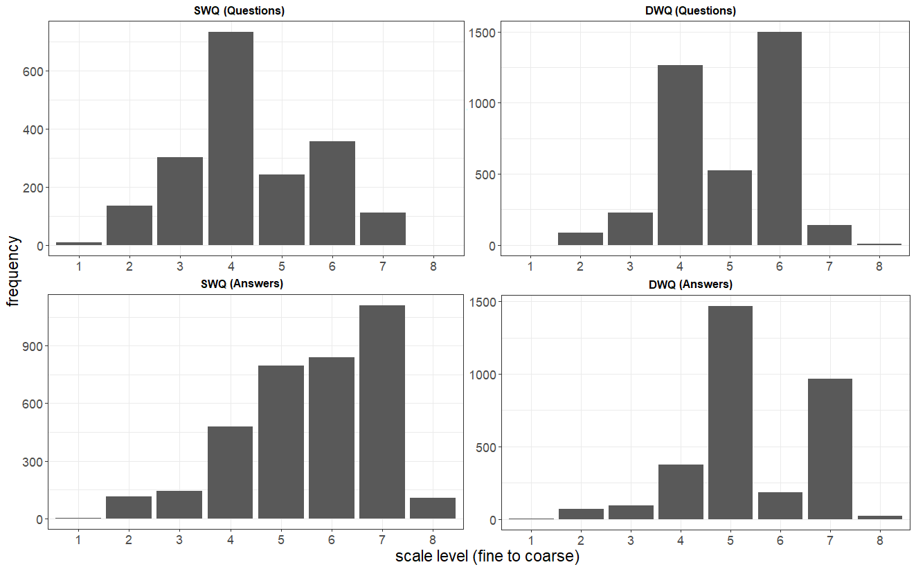
Figure 2 shows the distributions of place types in SWQs and DWQs. In DWQs, administrative divisions are almost twice as frequent as in SWQs. The extra detail (additional toponyms) included in the content of DWQs dominantly refers to administrative divisions. For example, Where in California is Disneyland? can be viewed as a SWQ, Where is Disneyland?, with extra details that shows what the inquirer already knows about its coarse location (in California). Hence, the differences between the two distributions illustrate where the additional detail is included.

Answers to SWQs (Figure 3) have a linearly incremental distribution (except for the coarsest level of scale). The figure shows the answers are generated with toponyms that belong to coarser levels of scale compared to places mentioned in the SWQs. The distribution of scale in the answers to DWQs shows a dominance of references to places of scale between the two mean values of the questions’ bi-modal distribution. Thus, people tend to generate responses at a level of scale greater than that of the place that is asked for, and lower than the scale of the places mentioned as additional details. This is because places at a same or coarser level of scale than the places in questions would lead to obvious, and hence irrelevant, answers. The clear distinction of the difference in answering SWQs and DWQs are shown in Table 2, enabling the comparison of the levels of scale of places identified in the questions and their answers.
| Level of scale in answers | Lower than | Equal (Between) | Greater than |
| SWQ | |||
| each value | 17.0% | 13.1% | 69.9% |
| min value | 25.8% | 16.0% | 58.2% |
| median value | 14.5% | 14.9% | 70.6% |
| max value | 10.6% | 5.9% | 83.5% |
| DWQ | |||
| each value | 7.2% | 59.6% | 33.2% |
| min value | 10.5% | 77.7% | 11.8% |
| median value | 6.7% | 77.3% | 16.0% |
| max value | 3.9% | 40.8% | 55.3% |
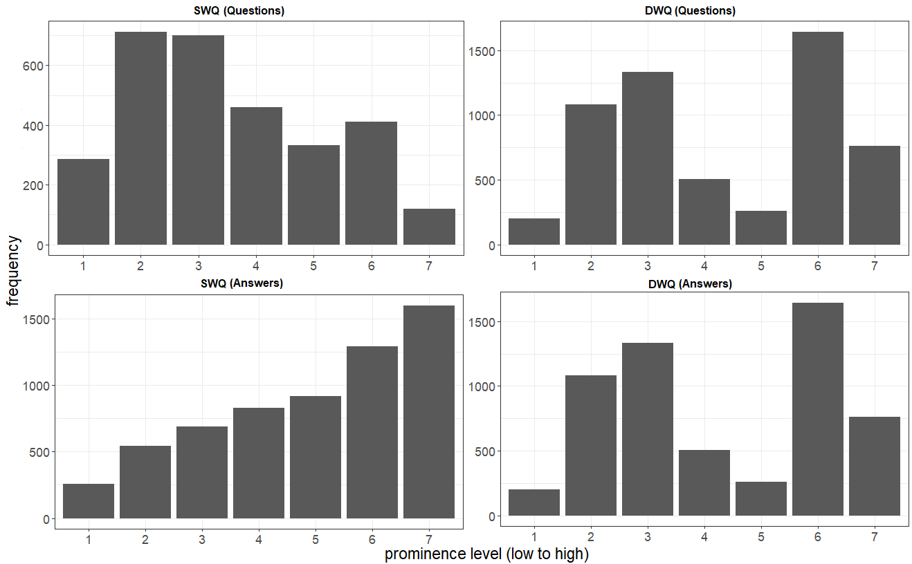
Figure 4 shows the distribution of prominence in SWQs, DWQs, and their answers. We observe that people ask about less-known places and answer referring to well-known ones. In DWQs, both less-known and well-known places are frequently observed. The well-known places in DWQs are the details presented in the content of the questions. In DWQs, inquirer’s state of knowledge can be estimated better, because the question contains what they already know and what they want to find out. Similar to the pattern observed based on scale, prominence levels of places in the answers to DWQs are mostly between the levels of prominence of the toponyms mentioned in their corresponding questions (Table 3).
| Prominence level in answers | Lower than | Equal (Between) | Greater than |
| SWQ | |||
| each value | 19.8% | 12.5% | 67.7% |
| min value | 30.7% | 14.7% | 54.6% |
| median value | 19.4% | 9.5% | 71.1% |
| max value | 9.7% | 7.9% | 82.4% |
| DWQ | |||
| each value | 8.7% | 68.4% | 22.9% |
| min value | 13.0% | 77.9% | 9.1% |
| median value | 6.8% | 79.7% | 13.5% |
| max value | 3.5% | 55.6% | 40.9% |
3 Sequence Distributions and Frequent Patterns
3.1 Sequence Distributions
Sequence distributions capture not only the content of sequences, but the way that the content is generated in the sequence (i.e., style). The length of sequences can be further investigated using sequence distributions. Figure 5 shows the sequence distributions of type, scale and prominence in the questions and answers. Here, we visualize only the first five positions of answer-sequences. While this long-tailed distribution contains answers up to a length of 13, the vast majority (95.84%) of answers have less than five toponyms. Most of the questions have only one or two toponyms, and the answers are mostly short as well (usually with less than three toponyms in their content). In Figure 5, only the top ten types are visualized, with the rest grouped as OTHER.
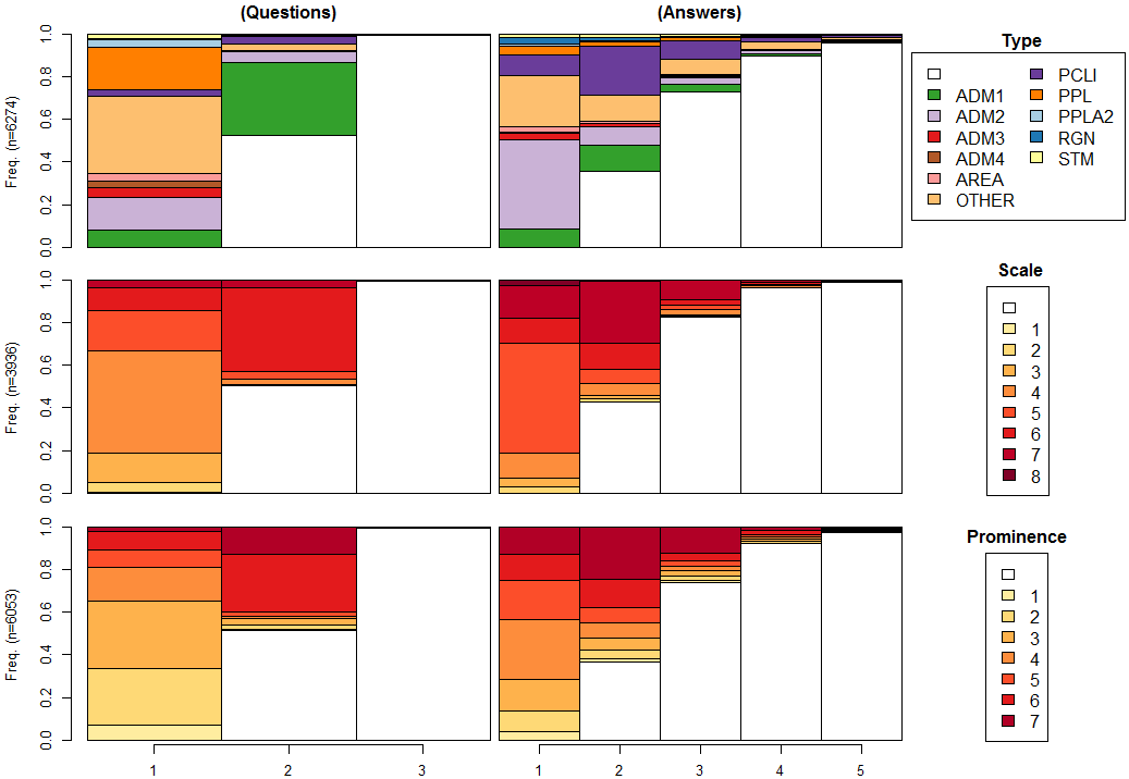
Based on the distributions of type, scale and prominence in the questions, the details in DWQs are likely to be found as the second toponym. In Figure 5, one can observe that these details usually belong to the type of ADM1111The codes for place types are described in Section 5. (first-order administrative divisions – i.e., states) or PCLI (independent political entities – i.e., countries). Similar patterns can be observed using scale and prominence – i.e., the second elements in questions belong to well-known places which are in coarse levels of scale.
Figure 5 shows the strong role of administrative places in the human-generated answers in this corpus. The answers are generated with mid-levels to coarse-levels of scale and presented starting with mid-levels followed by coarse levels in most cases. Similar patterns can be observed in terms of prominence; however, places in lowest and highest prominence levels can be found in the answers. When comparing the questions and answers based on type, we observe that while the questions ask about a diverse range of place types, the answers are mostly generated using the top ten types (i.e., the less frequent types labelled as OTHER are almost twice as frequent in the questions compared to answers).
3.2 Frequent Patterns
Frequent patterns describe the generalized patterns in human answering behavior. Stronger patterns of a generic class (e.g., scale) show the usefulness of the generic information to describe the human-generated answers. Figures 6, 7 and 8 illustrate the top ten patterns based on type, scale and prominence, respectively. These patterns are shown for all answers, answers to SWQs, and answers to DWQs.
Figure 6 shows that the top ten patterns in the answers are mostly generated with first and second orders administrative divisions and independent political entities. In the generic class, type, almost 60% of all answers are described through only ten sequence patterns. Ten patterns also cover 70% and 50% of the answers to DWQs and SWQs, respectively. The differences shows that answers to DWQs are more describable based on place type than the responses to SWQs. This is because in DWQs, some details are provided and people can therefore infer the inquirers’ information needs better. In SWQs, due to lack of context leads to more ambiguity and likely requires more subjective judgments in responses.
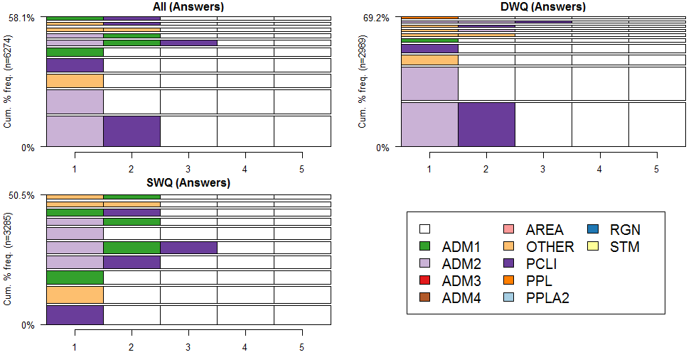
Figure 7 illustrates the top ten patterns based on scale. The coarse levels of scale constitute most of the frequent patterns. Answers covered by these patterns show that scale is an important generic information characterizing well human-generated answers. The comparison of the answers to DWQs and SWQs shows similar results to types. More than 80% of the answers to DWQs can be described using ten patterns based on scale. The style of these patterns shows that the answers are hierarchically presented (starting from finer levels followed by coarser levels of scale).
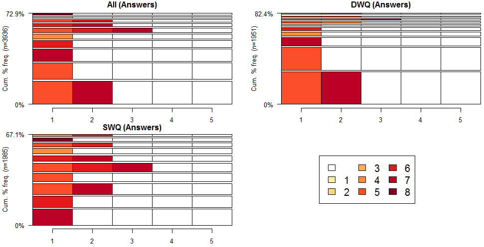
Figure 8 shows the ten most frequent patterns based on prominence levels. Most of the patterns are constructed with high levels of prominence. Similar to scale, a strong pattern in the style of answers can be observed – i.e., starting with less-known places followed by well-known ones. The patterns based on prominence have, however, less support in the data compared to the patterns derived from scale or type sequences. This observation can be explained by prominence being more tightly related to the specific context of the questions, compared to scale or type. For example, finding a highly prominent place reference may not be always possibleas prominent places are not uniformly distributed in the world.

4 Demonstration Examples
In this section, four examples are provided to demonstrate how generic form of answers (e.g., type-sequence) can be translated into their specific form (toponym-sequence).
Example 1: Where is Nagasaki? In Japan. The specific form and TSP encoding of this question-answer pair are shown below:
-
•
specific representation (question): [Nagasaki];
-
•
TSP encoding (question): type-sequence [ADM1], scale-sequence [6], prominence-sequence [4];
-
•
TSP encoding (answer): type-sequence [PCLI], scale-sequence [7], prominence-sequence [7];
-
•
specific representation (answer): [Japan]
Queries 1 and 2 show the SPARQL queries to derive the specific form of the answer using the information available in DBPedia and Geonames, respectively. The result of both queries is the unified resource identifier (URI) of Japan which is the correct specific representation of the answer. The query results are shown in Table 4.
| Knowledge Base | Q1 | A1 |
|---|---|---|
| DBPedia | Nagasaki | Japan |
| Geonames | Nagasaki | Japan |
Example 2: Where in Illinois is Cahokia? In St. Clair County, Illinois, United States:
-
•
specific representation (question): [Illinois, Cahokia];
-
•
TSP encoding (question): type-sequence [ADM1, PPL], scale-sequence [6, 4], prominence-sequence [6, 3];
-
•
TSP encoding (answer): type-sequence [ADM2, PCLI], scale-sequence [5, 7], prominence-sequence [3, 7];
-
•
specific representation (answer): [St. Clair County, United States]
Based on the SPARQL template, two queries (Queries 7 and 8) are used to translate the generic form of the answer to a specific form using DBPedia and Geonames. The results of the queries are shown in Table 7. Using DBPedia, the correct answer is among one of the three retrieved responses {[Collinsville, United States], [Illinois, United States], [St. Clair County, United States]}. The second response in the results can be easily filtered due to repetitive content (i.e., Illinois) considering the content of the question. However, the first one which is not mentioned in the human-generated answer cannot be avoided using only the type-sequence of the answer. Consequently, by considering the predicted scale-sequence of the answer, the correct response [St. Clair County, United State] can be derived (Table 7).
| Knowledge Base | Q1 | Q2 | A1 | A2 |
|---|---|---|---|---|
| DBPedia | Cahokia | Illinois | Collinsville | United States |
| Illinois | United States | |||
| St. Clair County | United States | |||
| Geonames | Cahokia | Illinois | St. Clair County | United States |
Example 3: Where is the Danube River, Europe? It originates in Germany’s Black Forest, and flows in a southeasterly direction through central and eastern Europe to the Black Sea:
-
•
specific representation (question): [Danube River, Europe];
-
•
TSP encoding (question): type-sequence [STM, CONT], scale-sequence [4, 8], prominence-sequence [6, 7];
-
•
TSP encoding (answer): type-sequence [PCLI, MTS, SEA], scale-sequence [7, 3, 7], prominence-sequence [7, 4, 5];
-
•
specific representation (answer): [Germany, Black Forest, Black Sea]
The SPARQL queries for finding the specific forms of answers of Example 2 are presented in Queries 5 and 6. The results of these queries are shown in Table 6. Using DBPedia, the results for the mountain range and the sea that are related to the Danube are the Black Forest and the Black Sea, while the country is not unique and ten countries (including the right one, Germany, based on the human-generated answer) are found in relation to the river. Here, we have only used the type-sequence of the answer, and using prominence we could limit the country lists to Germany (the only country in Level 7 of prominence in the results). Interestingly, the results using Geonames are incorrect. In Geonames, the river is stored as a coordinate point, which belongs to one country. Moreover, the relationships between Black Forest (originates) and Black Sea (flows to) to the river are not stored in Geonames due to its limited list of supported spatial relations – i.e., Geonames supports only containment.
| Knowledge Base | Q1 | A1 | A2 | A3 |
|---|---|---|---|---|
| DBPedia | Danube | Moldova | Black Forest | Black Sea |
| Ukraine | Black Forest | Black Sea | ||
| Germany | Black Forest | Black Sea | ||
| Romania | Black Forest | Black Sea | ||
| Croatia | Black Forest | Black Sea | ||
| Serbia | Black Forest | Black Sea | ||
| Austria | Black Forest | Black Sea | ||
| Bulgaria | Black Forest | Black Sea | ||
| Hungary | Black Forest | Black Sea | ||
| Slovakia | Black Forest | Black Sea | ||
| Geonames | Danube River | Romania | – | – |
Example 4: Where is Golden Gate Bridge? It is located between San Francisco and Marin County, in the U.S. state of California.:
-
•
specific representation (question): [Golden Gate Bridge];
-
•
TSP encoding (question): type-sequence [BDG], scale-sequence [5], prominence-sequence [4];
-
•
TSP encoding (answer): type-sequence [ADM2, ADM2, ADM1], scale-sequence [5, 5, 7], prominence-sequence [4, 4, 7];
-
•
specific representation (answer): [San Francisco, Marin County, U.S. state of California]
| Knowledge Base | Q1 | A1 | A2 | A3 |
|---|---|---|---|---|
| DBPedia | Golden Gate Bridge | San Francisco | Marin County | California |
| Geonames | Golden Gate Bridge | San Francisco | – | California |
5 Feature Codes
Table 8 shows the types which are mentioned in this paper. The complete list can be found in the Geonames website.
| Code | Description | Example |
|---|---|---|
| ADM1 | first-order administrative division (states, and provinces) | Oklahoma |
| ADM2 | second-order administrative division (counties) | Brevard County |
| ADM3 | third-order administrative division (cities) | City of Alhambra |
| ADM4 | fourth-order administrative division (towns) | Newburgh |
| AREA | a part of land without homogeneous character/boundaries | Theresienwiese |
| BDG | a bridge | Putney Bridge |
| FRM | a part of land dedicated to agricultural purposes | Branksome |
| HTL | hotels | The Carriage House |
| MT | mountains | Eagles Nest |
| PCLI | independent political entity | Paraguay |
| PPL | diverse type of populated places (e.g., cities, and villages) | El Granada |
| PPLA2 | seat of a second-order administrative division | Lake City |
| PRK | parks and recreational places | Franklin Square Park |
| RGN | an area with particular cultural character | Central Africa |
| SCH | schools and universities | Stuyvesant High School |
| STM | streams | Withlacoochee River |