Developing High Quality Training Samples for Deep Learning Based Local Climate Zone Classification in Korea
Abstract
Two out of three people will be living in urban areas by 2050, as projected by the United Nations, emphasizing the need for sustainable urban development and monitoring. Common urban footprint data provide high-resolution city extents but lack essential information on the distribution, pattern, and characteristics. The Local Climate Zone (LCZ) offers an efficient and standardized framework that can delineate the internal structure and characteristics of urban areas. Global-scale LCZ mapping has been explored, but are limited by low accuracy, variable labeling quality, or domain adaptation challenges. Instead, this study developed a custom LCZ data to map key Korean cities using a multi-scale convolutional neural network. Results demonstrated that using a novel, custom LCZ data with deep learning can generate more accurate LCZ map results compared to conventional community-based LCZ mapping with machine learning as well as transfer learning of the global So2Sat dataset.
1 Introduction
The Local Climate Zone (LCZ) classification framework was introduced as a climate-based classification of urban-rural areas for temperature studies [1]. The LCZ scheme (see Appendix, Figure 5) is composed of 17 urban and natural classes based on regions of uniform surface cover, structure, material, and anthropogenic activity [2]. In general, LCZs are culturally-neutral and are characterized by screen-height temperature apparent over dry surfaces on calm, clear nights in areas of simple relief [1]. Based on this concept, the integration of remote sensing data and data-driven methods have enabled global LCZ classification at 100 m spatial resolution [3].
1.1 Global Trends in LCZ Classification
The World Urban Database and Access Portal Tools (WUDAPT) is a community-based project which provided an automated LCZ classification protocol to produce LCZ maps of global cities using the random forest (RF) classifier. [3, 4]. Recent studies have extended LCZ mapping to national and continental scales, such as the United States [2], Europe [5], Hong Kong [6], and major cities in China [7]. Another approach in literature was improving the classification accuracy when employing deep learning over conventional machine learning algorithms [8, 9, 10, 11]. Furthermore, Zhu et al. (2019) introduced the large-scale So2Sat dataset which is comprised of Sentinel-1 and 2 image patches with corresponding LCZ labels for 42 global cities. The dataset has been tested and benchmarked using sophisticated deep learning models, demonstrating superior classification accuracy results over conventional methods [12, 13]. However, the WUDPAT protocol is limited to low classification accuracy and poor generalization ability [8, 12, 14], while the So2Sat dataset requires advanced domain adaptation techniques to fully harness its potential.
1.2 Deep Learning Based LCZ Mapping for Korea
This study aims to develop LCZ mapping for the Korean peninsula by developing LCZ training samples of major Korean cities and classifying using a multi-scale convolutional neural network (MSCNN). The major contributions of this study can be summarized by the following points:
(1) High-quality LCZ training samples for Korea: Adopted sampling method [3, 12] for scene classification via deep learning [8, 10, 11] to produce fundamental training samples for Korea.
(2) Assessment of classification accuracy: Evaluated classification accuracy using RF and MSCNN models with the custom LCZ training samples and transfer learning of the state-of-the-art So2Sat dataset [12], thereby investigating the effectiveness of custom and global LCZ datasets
2 Data and Methods
2.1 Input Data
The sampling phase requires a basemap, natural cover, and built-up cover layers. The specifications of each data type is displayed in Table 1. Sentinel-2 images were used as the main basemap and were acquired using the Copernicus Open Hub. Google Earth Engine cloud-free mosaics can also be used [15]. The Normalized Difference Vegetation Index (NDVI) is applied as the natural cover layer and the master building information (MBI) dataset, provided by the Electronic Architectural Administration Information System (EAIS), is used as the built-up cover. The MBI dataset includes building information of each major city in Korea such as building height, number of floors, area, and location. These input layers can be combined to help label sampling (see Appendix, Figure 6).
| Data | Main Function | Source |
|---|---|---|
| Sentinel-2 | Basemap and input (Bands 1 - 10) | Copernicus Open Hub |
| NDVI | Natural cover (LCZ A - LCZ G) | Sentinel-2 Bands 3 and 4 |
| MBI Building height | Built-up cover (LCZ 1 - LCZ 6) | EAIS |
2.2 Sampling Workflow
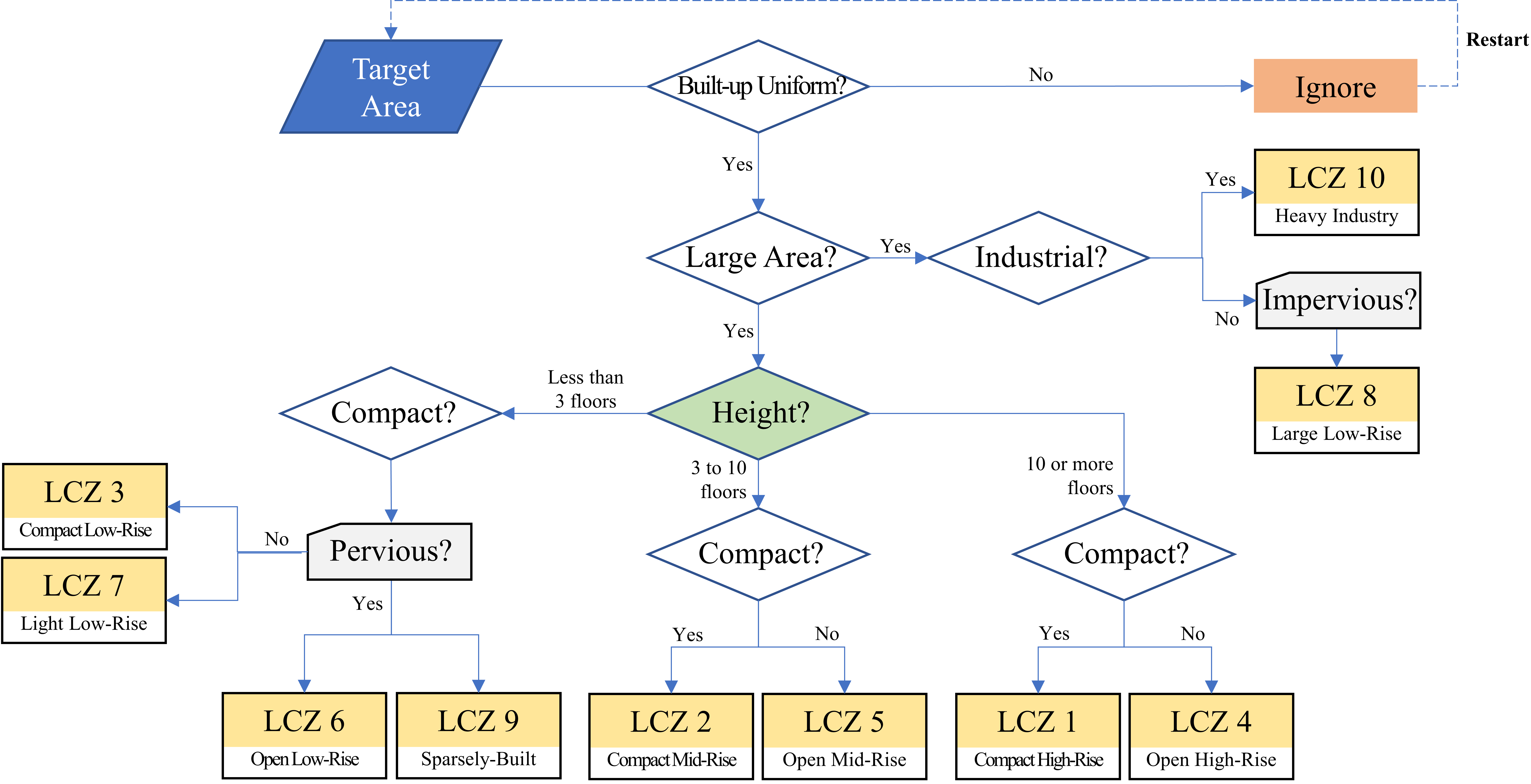
This study adopted a scene classification approach to create 32 by 32 pixel patches based on Liu et al. (2020) and to match the So2Sat’s patch size. The entire labeling workflow (see Appendix, Figure 7) is based on the workflow in Zhu et al. (2019). In this study, the LCZ labels are sampled as points which act as the patch’s centroid [10, 11, 12]. Larger image patches tend to improve classification accuracy due to local information [8, 10, 11]. Second, the LCZ labels are guided using MBI and reviewed with Google Earth and Google Street View to ensure correctness and completeness [12]. Finally, once a sufficient volume of training samples is accumulated, data augmentation is processed to modify class weights to alleviate the effect of imbalanced classes.
2.3 Assessment of Classification Accuracy
First, the RF is used to represent the WUDAPT method. Second, MSCNN is built with a multi-scale layer which uses three convolution layers with different kernel sizes (3, 5, 7 pixels), followed by five convolution layer blocks in order of convolution (CONV), batch normalization, ReLU activation function, and max pooling layers. A dropout out of 25% was added after the first fully-connected (FC) layer. MSCNN used the adam optimizer [16], batch size of 96, learning rate of 0.002, decay factor of 0.004, and early stop of 15. Third, the So2Sat dataset uses the benchmark ResNet for training [12]. The original layers are frozen, while two fully-connected dense layers are added to the end of the model for transfer learning [17].

3 Results and Discussion
3.1 Contribution 1: High-quality LCZ training samples for Korea
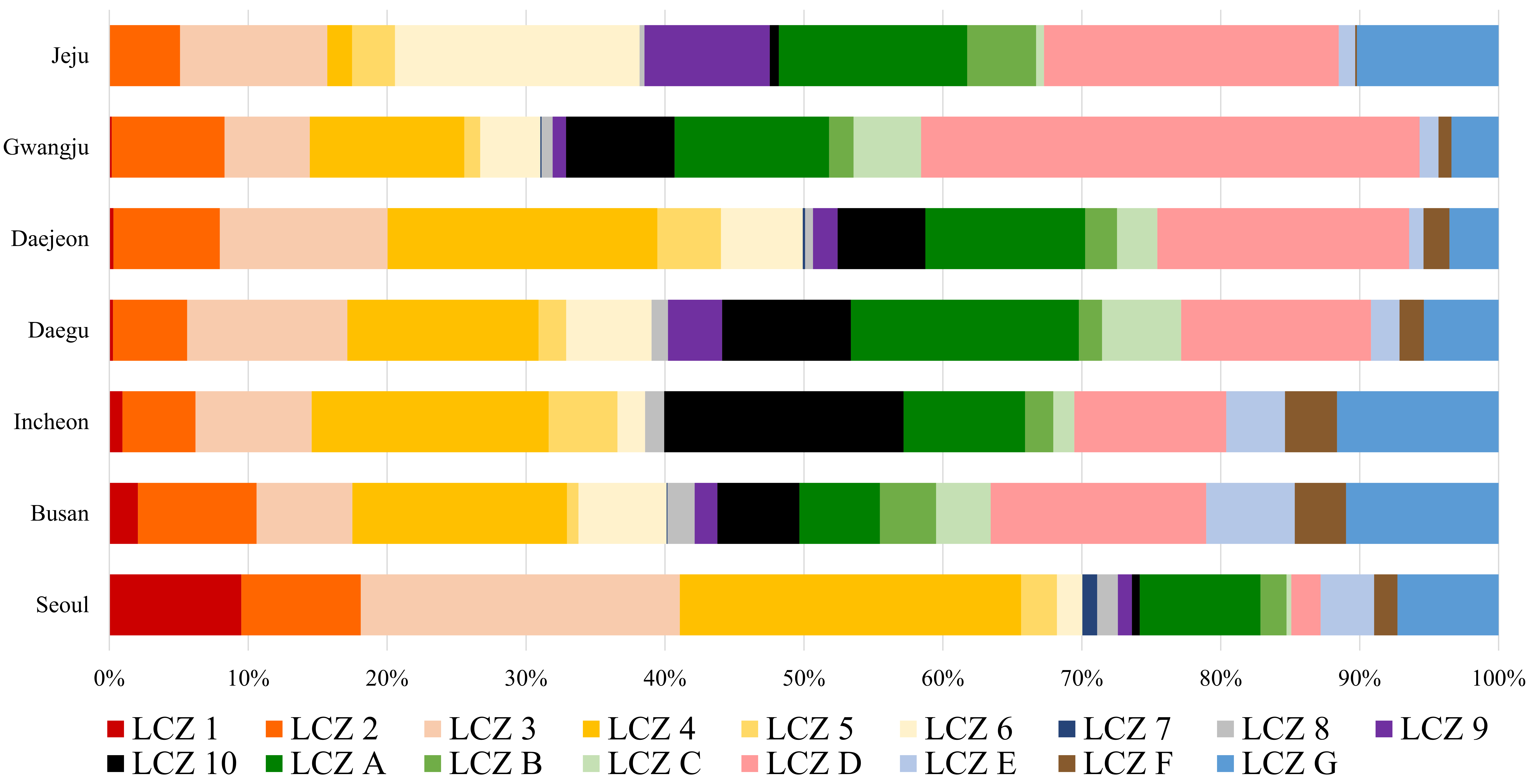
The distribution of training samples for major Korean cities are provided in Figure 2 with respect to each LCZ class. The different class proportions offer a glimpse of each city’s urban form and structure. This list is not exhaustive and we plan to continue increasing data volume and labeling quality. These training samples can then be used as the fundamental training sample dataset to generate a nation-level LCZ map of Korea.

3.2 Contribution 2: Classification Accuracy
LCZ classification was conducted for Seoul to produce 100 m resolution LCZ maps using the three models mentioned in Section 2.3. As organized in Table 2, MSCNN using the custom LCZ data outperformed all other methods with a superior overall accuracy of 83.88%. Compared to RF when using the custom data (74.27%), MSCNN demonstrates that deep learning is significant to improve accuracy, while the low accuracy of So2Sat (54.42%) implies that using MSCNN with the custom data is more effective than transfer learning a global dataset, in spite of the large-scale data volume.
| Model | Overall | Kappa |
|---|---|---|
| So2Sat | 54.42% | 48.60% |
| RF | 74.27% | 41.00% |
| MSCNN | 83.88% | 64.99% |

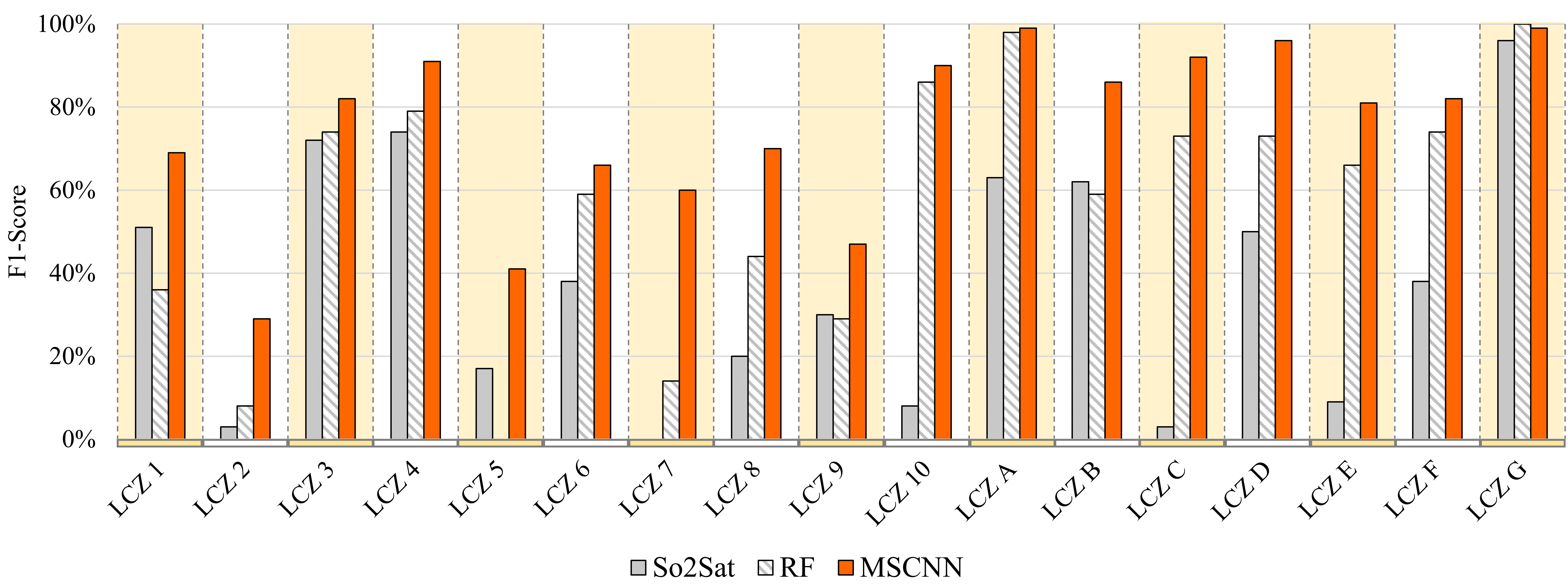
The F1-score results shown in Figure 3 indicate that MSCNN classified the highly heterogeneous features more effectively compared to RF and the So2Sat method. For instance, the built-up LCZ classes, such as LCZ 1 or LCZ 4 were more defined using MSCNN, especially in densely compact urban areas and even suburban and rural communities. The So2Sat method was able to classify built-up areas like LCZ 1, but transfer learning of the global dataset introduced confusion of natural cover in densely vegetated areas. This result can be attributed to the difference in crop fields and covers between global cities and Korea, which is particularly prevalent by seasonal variations. All of the models struggled to classify similar LCZ classes (below 50% F1-score), such as LCZ 2 and 3 as well as for LCZ 5 and 6 [9]. Future studies can integrate DSMs or building height information from GIS layers such as OpenStreetMap and the EAIS dataset.

4 Outlook and Future Work
Deep learning based LCZ classification methods are required to effectively monitor urban areas and to produce high quality LCZ maps that delineate the heterogeneous urban features effectively. Based on the progress of generating global-scale LCZ maps and datasets in recent studies, this study developed fundamental, custom data for LCZ mapping in Korea. The study’s results using MSCNN confirm that deep learning outperforms the shallow RF classifier used by WUDAPT, and that creating a novel, yet optimized labelled training sample data can be more efficient compared to transfer learning the large-scale So2Sat dataset. Future works will focus on increasing data volume and enhancing label quality, while exploring ways to integrate global datasets such as So2Sat more effectively. City-by-city comparisons of LCZ classification will also be conducted to investigate the generalization ability of the models and training sample data.
References
- [1] Ian D Stewart and Tim R Oke. Local climate zones for urban temperature studies. Bulletin of the American Meteorological Society, 93(12):1879–1900, 2012.
- [2] Matthias Demuzere, Steve Hankey, Gerald Mills, Wenwen Zhang, Tianjun Lu, and Benjamin Bechtel. Combining expert and crowd-sourced training data to map urban form and functions for the continental us. Scientific data, 7(1):1–13, 2020.
- [3] Benjamin Bechtel, Paul J Alexander, Jürgen Böhner, Jason Ching, Olaf Conrad, Johannes Feddema, Gerald Mills, Linda See, and Iain Stewart. Mapping local climate zones for a worldwide database of the form and function of cities. ISPRS International Journal of Geo-Information, 4(1):199–219, 2015.
- [4] Benjamin Bechtel, Paul J Alexander, Christoph Beck, Jürgen Böhner, Oscar Brousse, Jason Ching, Matthias Demuzere, Cidália Fonte, Tamás Gál, Julia Hidalgo, et al. Generating wudapt level 0 data–current status of production and evaluation. Urban climate, 27:24–45, 2019.
- [5] Matthias Demuzere, Benjamin Bechtel, Ariane Middel, and Gerald Mills. Mapping europe into local climate zones. PloS one, 14(4):e0214474, 2019.
- [6] Ran Wang, Chao Ren, Yong Xu, Kevin Ka-Lun Lau, and Yuan Shi. Mapping the local climate zones of urban areas by gis-based and wudapt methods: A case study of hong kong. Urban climate, 24:567–576, 2018.
- [7] Chao Ren, Meng Cai, Xinwei Li, Lei Zhang, Ran Wang, Yong Xu, and Edward Ng. Assessment of local climate zone classification maps of cities in china and feasible refinements. Scientific reports, 9(1):1–11, 2019.
- [8] Cheolhee Yoo, Daehyeon Han, Jungho Im, and Benjamin Bechtel. Comparison between convolutional neural networks and random forest for local climate zone classification in mega urban areas using landsat images. ISPRS Journal of Photogrammetry and Remote Sensing, 157:155–170, 2019.
- [9] Chunping Qiu, Michael Schmitt, Lichao Mou, Pedram Ghamisi, and Xiao Xiang Zhu. Feature importance analysis for local climate zone classification using a residual convolutional neural network with multi-source datasets. Remote Sensing, 10(10):1572, 2018.
- [10] Shengjie Liu and Qian Shi. Local climate zone mapping as remote sensing scene classification using deep learning: A case study of metropolitan china. ISPRS Journal of Photogrammetry and Remote Sensing, 164:229–242, 2020.
- [11] Johannes Rosentreter, Ron Hagensieker, and Björn Waske. Towards large-scale mapping of local climate zones using multitemporal sentinel 2 data and convolutional neural networks. Remote Sensing of Environment, 237:111472, 2020.
- [12] Xiao Xiang Zhu, Jingliang Hu, Chunping Qiu, Yilei Shi, Jian Kang, Lichao Mou, Hossein Bagheri, Matthias Häberle, Yuansheng Hua, Rong Huang, et al. So2sat lcz42: A benchmark dataset for global local climate zones classification. arXiv preprint arXiv:1912.12171, 2019.
- [13] Chunping Qiu, Xiaochong Tong, Michael Schmitt, Benjamin Bechtel, and Xiao Xiang Zhu. Multi-level feature fusion-based cnn for local climate zone classification from sentinel-2 images: Benchmark results on the so2sat lcz42 dataset. arXiv preprint arXiv:2005.07983, 2020.
- [14] Benjamin Bechtel, Matthias Demuzere, Panagiotis Sismanidis, Daniel Fenner, Oscar Brousse, Christoph Beck, Frieke Van Coillie, Olaf Conrad, Iphigenia Keramitsoglou, Ariane Middel, et al. Quality of crowdsourced data on urban morphology—the human influence experiment (huminex). Urban Science, 1(2):15, 2017.
- [15] Michael Schmitt, Lloyd H Hughes, Chunping Qiu, and Xiao Xiang Zhu. Aggregating cloud-free sentinel-2 images with google earth engine. ISPRS Annals of Photogrammetry, Remote Sensing & Spatial Information Sciences, 4, 2019.
- [16] Diederik P Kingma and Jimmy Ba. Adam: A method for stochastic optimization. arXiv preprint arXiv:1412.6980, 2014.
- [17] Bei Zhao, Bo Huang, and Yanfei Zhong. Transfer learning with fully pretrained deep convolution networks for land-use classification. IEEE Geoscience and Remote Sensing Letters, 14(9):1436–1440, 2017.
5 Appendix
The following figures are included to help users understand and replicate our sampling and classification procedure. Despite the difficulty of manually labeling training samples, we believe that optimizing and enhancing the input data is essential to ensure high quality LCZ maps.


