Demo Abstract: Indoor Positioning System in Visually-Degraded Environments with Millimetre-Wave Radar and Inertial Sensors
Abstract.
Positional estimation is of great importance in the public safety sector. Emergency responders such as fire fighters, medical rescue teams, and the police will all benefit from a resilient positioning system to deliver safe and effective emergency services. Unfortunately, satellite navigation (e.g., GPS) offers limited coverage in indoor environments. It is also not possible to rely on infrastructure based solutions. To this end, wearable sensor-aided navigation techniques, such as those based on camera and Inertial Measurement Units (IMU), have recently emerged recently as an accurate, infrastructure-free solution. Together with an increase in the computational capabilities of mobile devices, motion estimation can be performed in real-time. In this demonstration, we present a real-time indoor positioning system which fuses millimetre-wave (mmWave) radar and IMU data via deep sensor fusion. We employ mmWave radar rather than an RGB camera as it provides better robustness to visual degradation (e.g., smoke, darkness, etc.) while at the same time requiring lower computational resources to enable runtime computation. We implemented the sensor system on a handheld device and a mobile computer running at 10 FPS to track a user inside an apartment. Good accuracy and resilience were exhibited even in poorly illuminated scenes.
CCS CONCEPTS
• Computer systems organization → Real-time systems; • Human-centered computing → Ubiquitous and mobile computing; • Computing methodologies → Artificial intelligence; Machine learning.
keywords
Millimeter-wave sensor, IMU, Deep Learning, Indoor Positioning.
ACM Reference Format
Zhuangzhuang Dai, Muhamad Risqi U. Saputra, Chris Xiaoxuan Lu, Niki Trigoni, and Andrew Markham. 2020. Demo Abstract: Real-Time Positioning System in Visually-Degraded Environments with Millimetre-Wave Radar and Inertial Sensors. In Proceedings of The 18th ACM International Conference on Embedded Networked Sensor Systems (SenSys), Nov 16-19, 2020, Virtual Event, Japan.
1. Introduction
There is a long-standing and unsolved need to be able to locate emergency responders in indoor environments. Since satellite and radio positioning techniques perform poorly indoors, sensor-aided navigation such as that based on Visual-Inertial Odometry (VIO) has been increasingly adopted. State-of-the-art VIO algorithms have seen great success in tracking humans and robots (Leutenegger et al., 2015; Chen et al., 2019). However, the performance of camera sensors (Saputra et al., 2020) is impacted by visual degradation such as from glare, darkness, or smoke. Although an IMU is characterized as being egocentric and environment-agnostic sensor, it cannot perform reliable tracking on its own due noise and intrinsic bias (Chen et al., 2018).
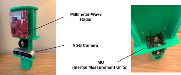
In this work, we propose to use mmWave radar, a low-cost, low-power, and lightweight sensor, in conjunction with the IMU to track first-responders in visually-degraded environments. The hypothesis is that the egocentric motions estimated by IMU can be significantly improved with sparse scene sensing from mmWave radar. The mmWave radar emits FMCW chirps measures the time-of-flight of reflected signals. The 3-by-4 antennas array exploits the phase difference to determine the angle of arrival. We convert the radar measurements into depth images for two-view odometry analysis. Note that these depth images are far sparser than RGB due to the limited sensor resolution. Given consecutive mmWave depth images and IMU sequences, a DNN (Lu et al., 2020) extracts optical flow-like features from the sensors and uses them to estimate the camera ego motion. We 3D printed a handheld device to hold the mmWave radar and the IMU as shown in Figure 1. A thermal camera and an RGB camera are also installed for trajectory visualization but are not used in the calculations. Thanks to the low data-rate of the mmWave sensor (in the order of 1000 points/second), poses of the handheld device can be calculated at a high output rate.
2. MMWave-Inertial Odometry
The point clouds obtained from mmWave radar are highly noisy due to diffuse scattering. Since the angular resolution of the antenna array is limited, the point cloud images can also be very sparse (Zhao et al., 2019). In order to combat the irregularities from mmWave radar, we overlay three consecutive point clouds and project them into one panoramic-view image before normalizing the values. A CNN feature extractor is used to capture mmWave features which are further fused with inertial features obtained from IONET (Chen et al., 2020). A mixed attention mechanism (Lu et al., 2020) is then employed to selectively fuse the most important features for ego motion estimation. On receiving the fused mmWave-inertial features, an RNN is used to model the long-term motion dynamics. Finally, three fully connected (FC) layers are introduced to regress relative motion transformation.
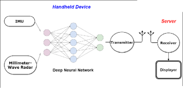
There is a practical challenge to run the model at runtime. The DNN model has 33.9 million parameters which takes 187 MB of storage. It takes a 4th generation Raspberry Pi 0.5s to generate a single inference. Instead, we use NVIDIA Jetson AGX Xavier instead to prototype a capable mobile computer which supports GPU and Deep Learning Accelerating engines in an embedded module under 30 W. The Xavier delivers an average inference latency of 0.034s, i.e., over 20 FPS processing rate. We use Robot Operating System (ROS) for sensor synchronization and data collection. ROS is a de-facto standard in robotics which allows easy system integration. Figure 2 exhibits a decomposition of the runtime sensor fusion and data processing system.
3. Demonstration
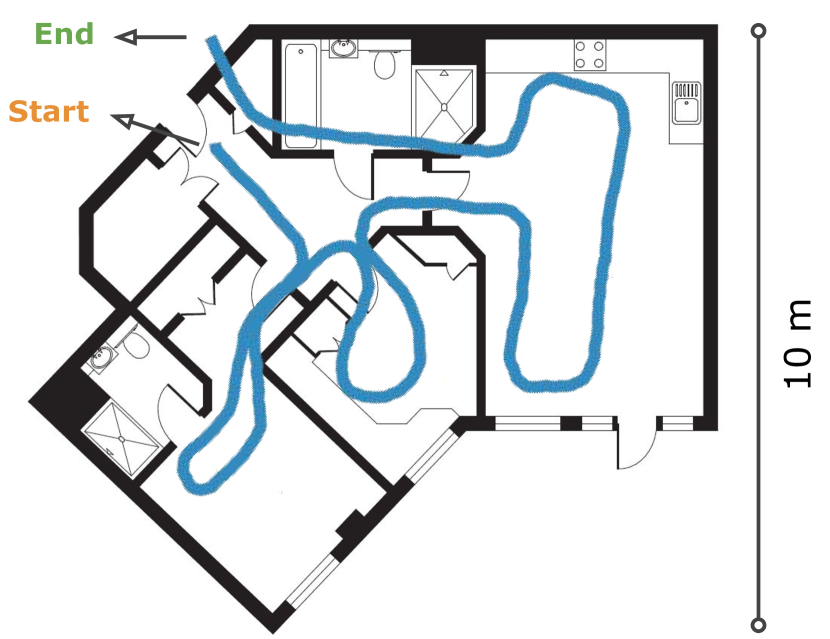
In this demonstration, we present the performance of the positioning systems for indoor tracking. The demonstration shows a person performing search procedures (used by firefighters in UK) throughout an apartment including a dark bedroom. Trajectory of a completed search is illustrated in Figure 3. The user is taking a battery-powered handheld device comprised of an NVIDIA Jetson AGX Xavier developer kit, a mmWave radar, and an IMU to deliver runtime computation and recording. Presented screens include the calculated poses from sensors, the ground-truth path generated by a Velodyne LiDAR, and a panoramic view of the point clouds from the mmWave radar. Excellent accuracy and reliability are seen even in poorly illuminated scenes.
Acknowledgement
This research has been financially supported by the National Institute of Standards and Technology (NIST) via the grant Pervasive, Accurate, and Reliable Location-based Services for Emergency Responders (Federal Grant: 70NANB17H185).
References
- (1)
- Chen et al. (2018) C. Chen, X. Lu, A. Markham, and N. Trigoni. 2018. IONet: Learning to Curethe Curse of Drift in Inertial Odometry. In Association for the Advancement of Artificial Intelligence.
- Chen et al. (2019) C. Chen, S. Rosa, Y. Miao, C. X. Lu, W. Wu, A. Markham, and N. Trigoni. 2019. Selective sensor fusion for neural visual-inertial odometry. In Proceedings of IEEE Conference on Computer Vision and Pattern Recognition.
- Chen et al. (2020) C. Chen, P. Zhao, C. X. Lu, W. Wang, A. Markham, and N. Trigoni. 2020. Deep Learning based Pedestrian Inertial Navigation: Methods, Dataset and On-Device Inference. In IEEE Internet of Things Journal.
- Leutenegger et al. (2015) S. Leutenegger, S. Lynen, M. Bosse, R. Siegwart, and P. Furgale. 2015. Keyframe-based visual–inertial odometry using nonlinear optimization. In The International Journal of Robotics Research 34, 3 (2015), 314–334.
- Lu et al. (2020) C. X. Lu, M. R. U Saputra, P. Zhao, Y. Almalioglu, P. P. B. de Gusmao, C. Chen, K. Sun, N. Trigoni, and A. Markham. 2020. milliEgo: Single-chip mmWave Radar Aided Egomotion Estimation via Deep Sensor Fusion. In ACM Conference on Embedded Networked Sensor Systems (SenSys).
- Saputra et al. (2020) M. R. U. Saputra, P. P. B. de Gusmao, C. X. Lu, Y. Almalioglu, S. Rosa, C. Chen, J. Wahlström, W. Wang, A. Markham, and N. Trigoni. 2020. Deeptio: A deep thermal-inertial odometry with visual hallucination. IEEE Robotics and Automation Letters 5, 2 (2020), 1672–1679.
- Zhao et al. (2019) P. Zhao, C. X. Lu, J. Wang, C. Chen, W. Wang, N. Trigoni, and A. Markham. 2019. mID: Tracking and Identifying People with Millimeter WaveRadar. In 15th International Conference on Distributed Computing in SensorSystems (DCOSS).