Lifelong update of semantic maps in dynamic environments
Abstract
A robot understands its world through the raw information it senses from its surroundings. This raw information is not suitable as a shared representation between the robot and its user. A semantic map, containing high-level information that both the robot and user understand, is better suited to be a shared representation. We use the semantic map as the user-facing interface on our fleet of floor-cleaning robots. Jitter in the robot’s sensed raw map, dynamic objects in the environment, and exploration of new space by the robot are common challenges for robots. Solving these challenges effectively in the context of semantic maps is key to enabling semantic maps for lifelong mapping. First, as a robot senses new changes and alters its raw map in successive runs, the semantics must be updated appropriately. We update the map using a spatial transfer of semantics. Second, it is important to keep semantics and their relative constraints consistent even in the presence of dynamic objects. Inconsistencies are automatically determined and resolved through the introduction of a map layer of meta-semantics. Finally, a discovery phase allows the semantic map to be updated with new semantics whenever the robot uncovers new information. Deployed commercially on thousands of floor-cleaning robots in real homes, our user-facing semantic maps provide a intuitive user experience through a lifelong mapping robot.
I Introduction
The raw information map where a robot saves a representation of its sensed information is essential to the robot’s tasks such as planning, navigation, and obstacle avoidance. However, because it consists of low-level information which is difficult for humans to comprehend, it is not a suitable representation to use for a shared understanding of the world with the user. A semantic map on the other hand is a richer representation of the environment that can be understood by both the robot and the user. It is better suited to be a common frame of reference and a user-facing representation.
We employ semantic maps in our fleet of floor-cleaning robots where users use them extensively to interact with their robots. Our robots use a visual SLAM (vSLAM [5]) localization system to generate and maintain a lifelong map [2] of its environment. Our semantic map which consists of walls, doors, and rooms of the home is generated through algorithms [9] and user annotations. The semantic map is central to the user’s interactions with the robot. It enables intuitive experiences such as cleaning a specific room through an app or voice command.
Deploying semantic maps on a large fleet of robots exposed several common challenges in robot mapping that needed to be addressed in the context of semantic mapping. Noise in the sensing, dynamic objects in the environment, and the robot uncovering new space that it had not previously explored are three such problems that occur regularly in practical robots. We present solutions for these specific problems through a framework that is general enough to handle other similar problems.
In real-world situations, under noisy sensing and dynamic environments, the low-level information may be sensed differently between different robot runs, whereas the high-level semantics of the environment are not expected to change significantly. As a user-facing representation, it is desirable that the semantic map is stable across slight perturbations of the underlying raw map, but flexible to account for significant and semantically meaningful changes in the environment.
The semantics, once established, are the common frame of reference for the robot and user. For instance, the user can intuitively communicate to the robot to clean a particular room and the robot would know exactly what to do. It is essential that once semantics have been exchanged between the user and the robot, they remain valid for the lifetime of the robot. Semantic maps have been discussed extensively in the literature [10, 11, 17, 20, 8]. They can result in better understanding of indoor maps [21, 18, 25] and outdoor spaces [12, 23], and can be useful in tasks such as planning [7]. While several works address the challenges in semantic maps in a single robot run, relatively fewer have focused on multiple sequential runs [15, 6], which is a requisite for lifelong mapping.
When a lifelong mapping robot performs a new run (called mission), it is normal to update its raw map using recent information from its sensors. Every raw map update must be accompanied by an update of the semantic map. The advantage of updating the raw and semantic map every mission is that the robot maintains the most recent belief of its environment. For lifelong mapping, localization in dynamic environments [22], efficient management and update of maps [3, 19], and map summarization [4, 16] have been studied previously. The challenges in ensuring valid semantics for lifelong robots have not been not addressed.
Semantic constraints [13, 8], particular dynamic ones [1] are an important aspect of maps. Semantics are often constrained by how they relate to each other and to the raw map. An example constraint in our system is that doors must be attached to a wall. Unsuccessful update of semantics implies that there are inconsistencies (or conflicts) in the constraints. For instance, a door which previously separated two rooms may be inconsistent by appearing between two different rooms after an unsuccessful update. When semantics are updated incorrectly, the assumption that the robot and user share a common understanding of the environment is violated. We use algorithms to detect conflicts and resolve them. For conflict resolution, we propose the use of an additional map layer called map-meta layer with some additional meta-semantics. Use of multiple-layered maps is not new in the literature. For instance, Zender et al. [24] use multiple layers, with each layer representing a different level of abstraction. We use the additional map layers for explicitly handling the inevitable inconsistencies over sequential map updates.
If the semantic map update is not successful despite the meta-layer based resolution, the map update may be discarded and the map reverted to the valid state from the previous mission.
Apart from maintaining previously established semantics, when the robot senses significant changes in the environment, there is potential for discovering new semantics. A discovery step enables computation of these semantics and their annotation on the map.
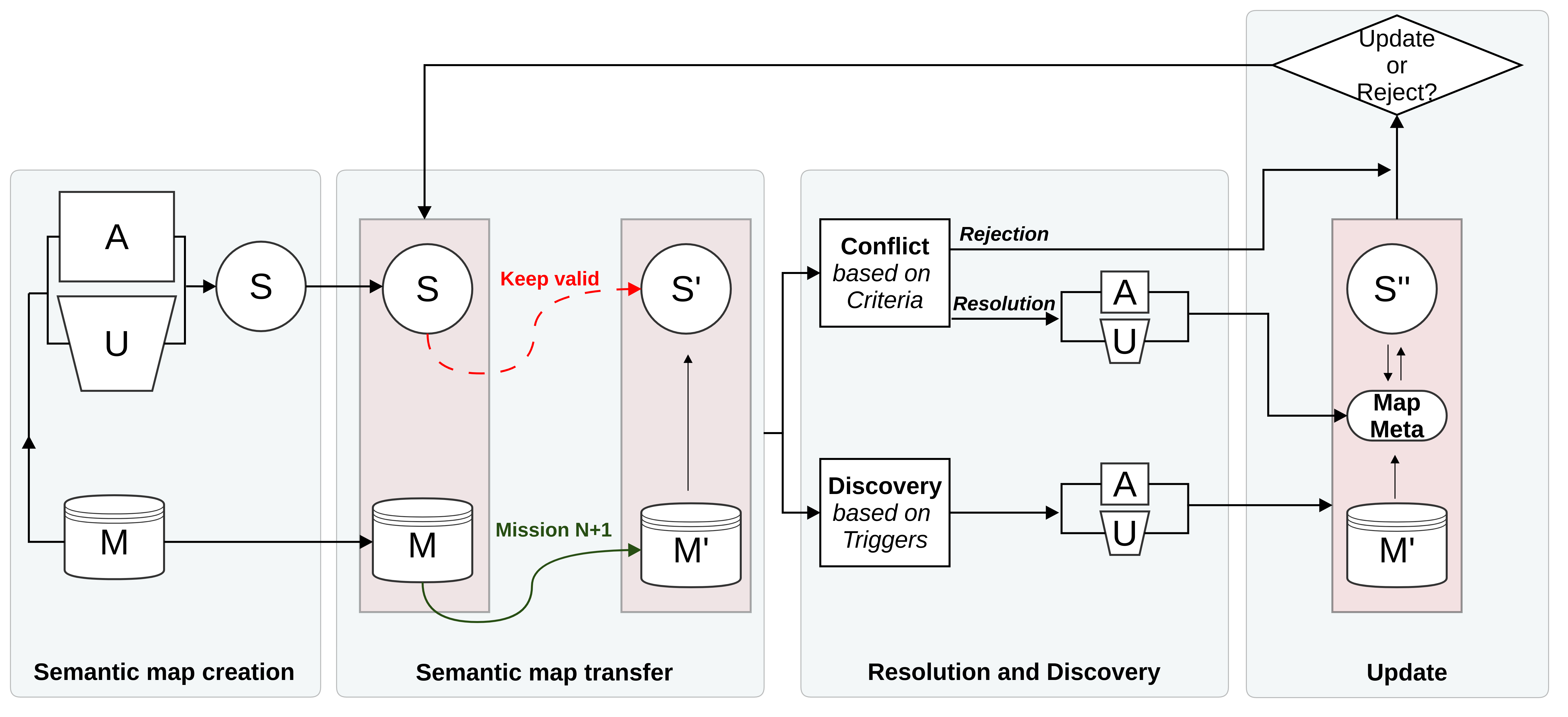
Figure 1 shows a block diagram of our system that consistently updates the semantic map across multiple missions while allowing for the robot to learn and incorporate environment changes into the semantic map. We motivate and illustrate the semantic map system through our use-case of floor-cleaning robots. Our semantics are derived on simple 2D floorplan maps, but we believe the building blocks and principles described in this paper are useful for other complex maps that involve semantics and constraints. The internal algorithms for the building blocks are explained at a high level with less emphasis on the details because the exact algorithms will vary greatly depending on the robot’s type and its purpose.
The paper is organized as follows. Section II describes our robot’s localization and mapping system, semantics and constraints, and the various modules of the semantic map update system. The problem of jitter in robot’s sensed map is addressed by our algorithm to transfer semantics from mission to mission in Section III. Dynamic objects can lead to different types of semantic conflicts. Conflicts, their automatic detection, and resolution using meta-semantics are explained in Section IV. Section V handles discovery of new space and finally Section VI recaps the update step of the semantic map system. Quantitative results in Section VII show our system’s efficacy on hundreds of real home maps.
II Semantic map system overview
II-A SLAM to Semantic map
Our robots use a visual SLAM [5] (vSLAM) algorithm that tracks visual landmarks and integrates various sensor modalities to generate a map of the house. Once generated, the vSLAM map is updated for the lifetime of the robot across hundreds of missions using efficient techniques for managing the complexity while retaining its efficacy [2].
The vSLAM map is crucial for the robot to localize itself accurately at different locations and times in the home. Another important map in the system is the Occupancy map that represents a top-down view of the home where white represents free areas, black represents occupied areas where walls or objects were sensed (called obstacles), and grey represents unexplored regions. This map is saved internally through a set of sub-grids that are inter-connected through pose constraints and are allowed to move across each other[14]. The pose constraints come from the vSLAM algorithm and hence there is a tight coupling between the occupancy map and the vSLAM localization system. Figure 2 shows an example of our two-dimensional occupancy map.
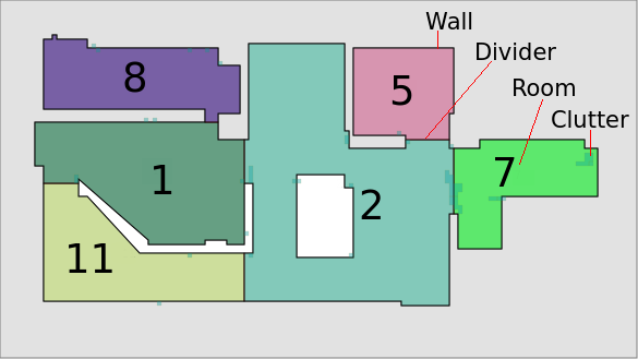
Because the obstacles are detected by a bump sensor of a limited resolution and due to uncertainty in a robot’s estimate of its own pose, the occupancy map can be noisy and difficult for a user to comprehend. Extraction of walls, dynamic objects (called clutter), rooms, and dividers from the occupancy map yields a semantic map of Figure 3, which is much easier to understand. Shown as Semantic map creation module in Figure 1, the semantics are both estimated automatically [9] and annotated directly by the user through an app interface.


II-B Multiple missions and the Semantic map
After the semantic map has been created, in subsequent missions, the robot may sense its world differently because of changes in the world or uncertainty in the robot’s representation of the world. Further the vSLAM system constantly updates the robot’s position and improves its belief about its world as it observes visual information. Hence even pixels representing static objects may move slightly in the occupancy map to reflect this belief. For instance, Figure 4 shows the occupancy map of the same space as Figure 2, but at the end of a different mission. The red and blue ovals show the key changes sensed by the robot. The red ovals show previously connected obstacles now disconnected either due to moved objects or sensing errors. The blue oval shows a previously open path closed. Here, the robot sensed obstacles where the previous doorway was and decided that it can not enter the room.
Although the underlying raw map varies slightly with each mission, the user is generally not interested in these perturbations because semantic concepts tend to be stable in a home. We would hence like to show the user a stable semantic map by transferring the semantics correctly from the previous map to the new one.
Figure 1 shows that as a robot performs a new mission, it updates its internal map (). The requirement for the Semantic map transfer block is that the semantics are updated () while remaining valid. Successful transfer of semantics is shown in Figure 5. All the rooms and dividers are reproduced correctly in the transferred map. An unsuccessful transfer attempt shown in Figure 6 is undesirable because some rooms have been lost and others have changed their shape significantly.
| Semantic | Physical meaning | Constraint | Motivation for constraint |
|---|---|---|---|
| Occupancy pixels | Occupied regions in map | Must be sensed by robot | Used as cost map in planning, constraint |
| helps use robot’s best estimates for occupied pixels | |||
| Clutter | Temporary/dynamic objects | Lies on occupancy pixels | Yields accurate visualization on semantic map |
| Wall | Shape of environment | Within a distance of occupied pixels | Yields accurate representation of rooms |
| Divider | Boundary between rooms | Ends on wall or another divider | Enclosed rooms are well-defined |
| Annotated by user | User is final authority on segmentation of the space | ||
| Room | Spaces in the environment | Defined by wall sections and dividers | Room polygon tightly corresponds to physical space, |
| hence robot can cover space satisfactorily |
II-C Semantic constraints
The semantic map for our floor-cleaning robot is designed with several constraints. While some constraints reflect practical limitations of the robot’s application, others ensure consistency in the semantic map’s visualization. Table I lists the semantics and their constraints in our semantic map. To emphasize the significance of constraints, let us consider the constraint enforced on the room semantic. A room is an enclosed space in the home, defined by walls and dividers. Walls are constrained to lie within a threshold distance of a sensed occupancy pixel and dividers must end on a wall or on another divider. This means that the room polygon thus described tightly fits the physical walls of the home as sensed by the robot.
II-D Conflict resolution and discovery
Each semantic map update must be guaranteed to maintain all the defined constraints. If semantics become invalid because of a constraint violation, this is automatically determined as a Conflict using various criteria in Figure 1. Conflict resolution is done either through algorithms or requesting user input.
To aid conflict resolution, we add an additional layer called Map Meta to the semantic map. The role of the meta-semantics layer is to add or remove relevant pieces of information that make the semantics valid while keeping the raw map unaltered. When valid resolution is not possible, the map update is rejected and the semantic map reverts to the earlier state. When user input is requested for conflict resolution, the user can either provide additional information to fix the map or reject the update.
At the end of each mission, the robot also determines if the map has changed significantly and if there is a possibility of annotating new semantics. This Discovery phase in Figure 1 enables new semantics to be added through algorithms or user input.
Next, the general solutions for the three common problems of jitter, dynamic objects, and new space are described.
III Transfer of map semantics
The first key problem in dynamic environments is to keep the semantic map stable even though the underlying raw map may jitter. The problem can be viewed as one of transferring the semantics from the previous raw map to the current raw map. Note that our robots already have a very strong vSLAM framework for tracking visual landmarks in the home across missions. Further, our semantics have a spatial component by virtue of being represented on a 2D map. A natural solution is to leverage the vSLAM framework with modifications to track the spatial components of the desired semantics. At the beginning of a robot’s mission, we integrate the vertices of the rooms and the dividers into the vSLAM system as explicit spatial points to track. As the robot moves and updates its location and map, the locations of the rooms and dividers get tracked by the vSLAM system. The room vertices and dividers move according to the motion estimated by the underlying vSLAM system. At the end of the mission, vSLAM returns motion estimates for the rooms and dividers. It is not sufficient to use these estimates as the final result since the current shape of the rooms or walls may have changed due to removal and adding of clutter objects to the wall, opening and closing of doors, or moving of large pieces of furniture. Further, the semantic constraints we defined in table I for walls required them to be within a threshold distance of sensed occupied pixels. Similarly, rooms boundaries were constrained to consist of wall sections and dividers. In order to guarantee these constraints, we first estimate the new walls from the occupancy map, associate the previously tracked divider end-points to the new walls, and then reconstruct the room shape from the new walls and dividers. Figure 7 shows the tracked boundaries and dividers visualized underneath the final boundaries and dividers in an example map. It shows the inaccuracy in the tracked room shape and dividers - they do not line up exactly with the walls in the new map. Divider end-point association and room reconstruction are hence essential for maintaining the specified constraints.

It is also important to keep wall and clutter semantics consistent across maps. We achieve this by using the tracked room shapes again. Obstacles in the new occupancy map that are within a threshold distance of the tracked room boundaries are labelled as wall obstacles. Obstacles that lie in the interior of previously tracked room boundaries are labelled as clutter obstacles. Wall estimation is done on the new map after this wall and clutter classification of obstacles. The result is that walls and clutter are consistent between the previous and new maps.
IV Semantic map conflicts
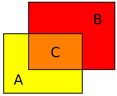
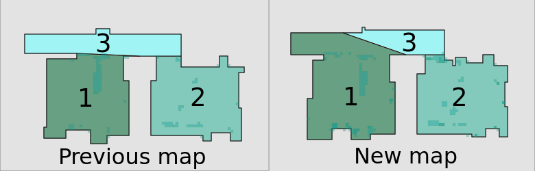
The transfer algorithm 1 can result in a semantic map with conflicts. We use precision and recall of rooms to determine when the transfer is successful. Figure 8 illustrates the precision and recall for a single room. We compute the precision and recall for each individual room in the map. Semantics transfer for a given mission is deemed successful, if all the rooms in the previous map have been transferred to the new map with precision and recall higher than a threshold. Several other criteria may be used, such as failure to transfer all dividers, large unexpected change in room shape, and change in connectivity between rooms.
Successful semantics transfer is shown in Figure 9 where all rooms from the previous map on the left have a high precision and recall in the transferred new map. Figures 10 and 11 show examples of failures.

IV-A Conflict resolution and the need for meta-semantics
The second key problem is of dynamic objects in the home. As objects move around in between missions, they can cause significant changes in the occupancy map. The constraints defined for walls and room boundaries mean that when the sensed occupancy pixels differ greatly between missions, it may not be possible to satisfy all constraints. One solution is to alter the robot’s raw map so that the semantics may be recovered. However this is not desirable because the raw map has implications for low-level robot behavior and planning.
We propose introducing an additional layer of meta semantics for conflict resolution. Represented as Map Meta in Figure 1, it enables the recovery of semantics while keeping the raw map unaltered. Following are some examples of common sources of conflict and recovery.
IV-A1 Disconnected walls
The previous map’s walls may be broken up into disjoint sections in the new map. When this happens, despite correct placement of the previous dividers, the new rooms cannot be reconstructed correctly from the walls and dividers. To solve this problem, we take the difference between the tracked room boundaries from algorithm 1 and the newly estimated walls. The difference is processed to obtain sections that were wall in the previous map and are not wall in the new map. Adding back these connected components to our wall estimation algorithm makes the wall connections reappear in the new map. The proposed corrections are biased towards relying on information from the previous map.
Figure 12 shows the previous map and the result of semantic transfer. The walls that got disconnected (highlighted in red) cause the room shapes to not be reconstructed correctly. The underlying cause of the disconnections is apparent in the corresponding raw occupancy maps shown in Figure 13.
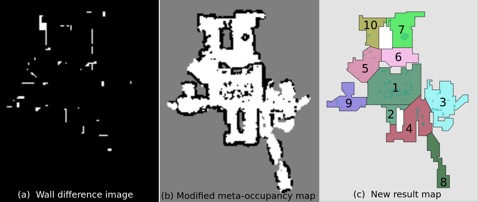
By adding back the wall difference image shown on the left in Figure 14 at appropriate sections, we recover a connected occupancy map shown in the center. Only difference sections that adjoin failed rooms are added back. Performing wall estimation and semantics transfer on this corrected occupancy map results in the correct result on the right.
IV-A2 Newly connected walls
This is the converse problem to disconnected walls - two wall sections that were disconnected in the previous map appear to be connected in the new map. The solution is the converse - we take the difference image between the free space within the tracked room boundaries and the free space within the new walls. The connected components from this difference image represent sections that are free in the previous map but wall in the new map. Adding back these free sections to the occupancy map yields the original openings between walls.
The corrected occupancy map and difference sections are not saved directly in the robot’s occupancy pixels, but as meta-occupancy pixels in the Map Meta layer. Note that adding back all the wall and free difference sections estimated between the previous and new map will result in a corrected occupancy map that is identical to the previous occupancy map. This would mean that the robot disregards any newly sensed information from the environment and is not desirable. We avoid this by only adding difference sections that adjoin rooms that failed to transfer and only if the difference sections are smaller than a pre-determined threshold. Thus, relatively small corrections are made to the map. Large changes sensed by the robot are always kept as is.
IV-A3 Additional dividers
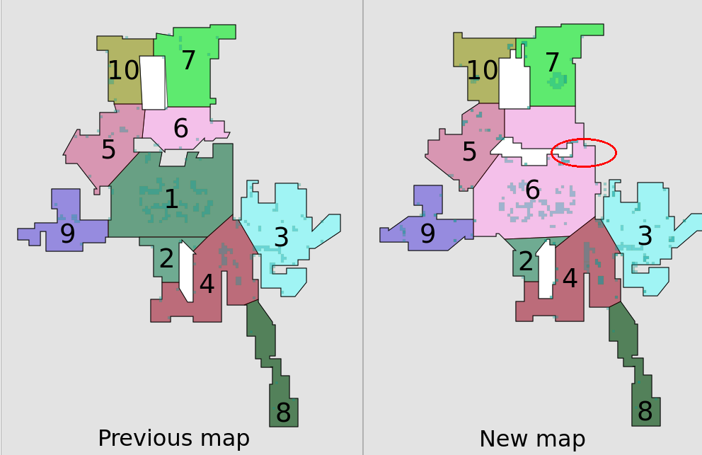
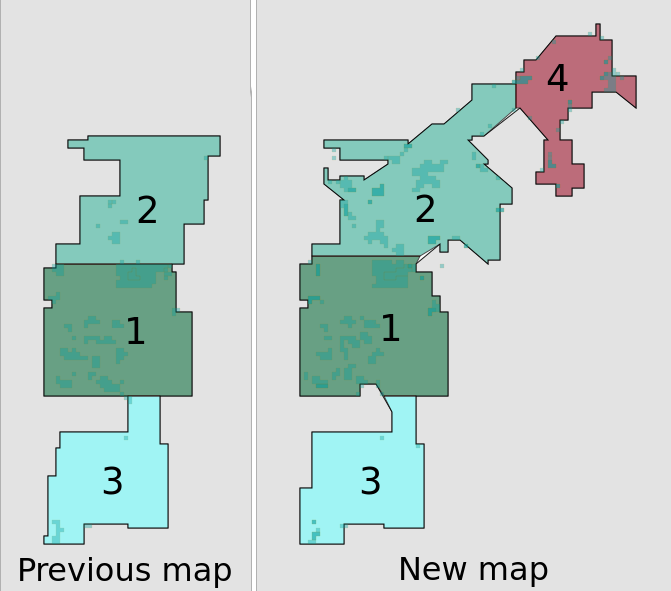
The third key problem mentioned earlier was that of new space being explored by the robot. Sometimes it becomes necessary to add additional dividers to keep the previous and new map’s room boundaries consistent. For example, imagine that a new passage connects previously disconnected rooms in a home. An example of this is shown in Figure 15. In a new mission, the robot explored and found a connecting space between previous rooms. Since this region was unexplored in the previous map, the difference information of Sections IV-A1 and IV-A2 does not help. The new connection between the previous rooms causes ambiguity for the robot. This conflict can be detected automatically and can be solved either through user input or by automatically placing additional meta-dividers. Meta-dividers are placed by determining which rooms were lost and adding back all the tracked boundary segments of the lost room. The meta-divider based room recovery shown in the bottom of Figure 15 shows successful recovery of all the previous room shapes and inference of a new room.

| Meta-semantic | Relaxed constraint | Corresponding semantic (and constraint) |
|---|---|---|
| Meta-occupancy pixels | Need not be sensed by robot | Occ. pixels ( Must be sensed by robot) |
| Meta-divider | Ends on wall or meta-divider | Divider (Ends on wall or divider, |
| Not annotated by user | must be annotated by user) |
IV-B Map Meta layer
Meta-semantics added to the map meta layer help re-establish the original set of semantics. They hence have a form that is similar to the original semantics. However, since they need to explain an underlying conflict, the constraints on them have to be relaxed.
For example, we added meta-occupancy and meta-divider semantics to the Map Meta layer. The meta-occupancy pixels are a version of the occupancy pixels, but the requirement that the occupied regions represent real obstacles is not met. A meta-divider is like a divider. But unlike a divider which has to have been annotated beforehand at specified regions of the map, it can be drawn anywhere as required. The relaxation in the constraints of the Map Meta layer semantics allows flexibility in the system to resolve conflicts and guarantee the constraints of the original semantics. Table II summarizes our meta-semantics and their relaxed constraints.
V Discovery
The third key problem in life-long mapping is exploration for previously unseen space by the robot. We have seen an example of this problem when it yields conflicts in Section IV-A3. In general, for a robot that constantly updates its map across missions, a mechanism to discover new semantics is essential. The robot must have the ability to process the change in its map and determine if there are potentially new semantics to be discovered. When pre-determined conditions are triggered, our system launches a discovery phase to gather new semantics from the raw map. Discovery of new rooms in the home is one such example.
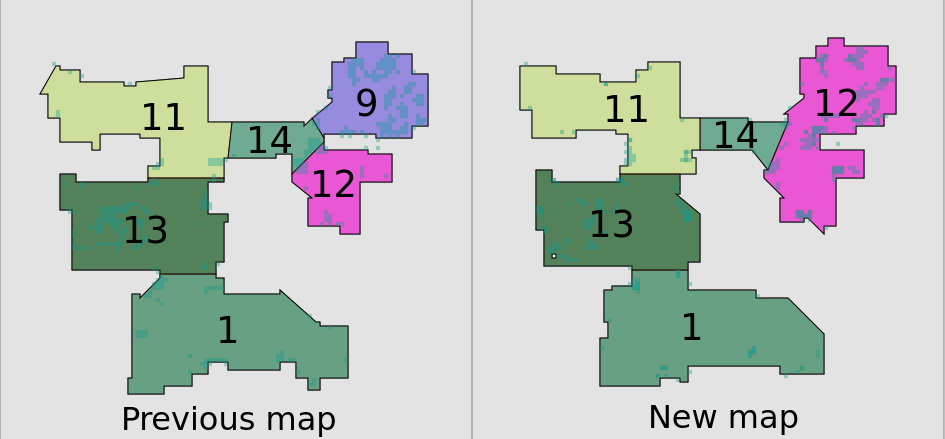
When any previous room appears to grow larger than a given threshold in the new map, we trigger discovery of new rooms in the map by running an automatic divider estimation algorithm in the grown region. Figure 16 shows an example. The map at the end of a new mission shows the previous rooms correctly transferred and a new room added in the newly explored section of the home. Once the new semantics are discovered, they become available for the robot’s use and are subsequently maintained by the semantic map system.
VI Update
Updating the semantic map with new information allows the robot to use the information for future missions. The consequences of updating the robot’s semantic map with an invalid one are unexpected robot behavior and poor user experience. To avoid these, the validity of the semantics and their mutual constraints are verified automatically at the end of the semantics transfer, conflict resolution, and discovery phases. Only when deemed valid, the new semantic map is set as the robot’s map for future missions. If found invalid, the robot reverts to the previous map at the cost of losing information from the new mission.
VII Results
The successful use of our semantic maps by thousands of real users is the most significant result of this work. We also benchmark our system on a large internal data set from real homes with cleaning missions performed under no explicit user instructions. The data set hence represents realistic usage of a consumer robot. For quantitative evaluation in this paper, we present results on a small randomly chosen set of robots and missions from our internal data set.
We use the precision-recall based criterion described earlier to determine when a semantic map is successfully updated. Table III shows the error rate - the fraction of all missions where the semantic map update failed. Running the semantic map transfer algorithm 1 as a baseline results in an error rate of . Including the meta-occupancy semantic and re-estimating walls and clutter based on the meta occupancy grid reduces the error to . Including the meta-divider semantic along with the meta-occupancy results in an error rate of . We thus have a highly accurate system for consistent update of semantics across the multiple missions.
| Condition | Error rate |
|---|---|
| Semantic map transfer (baseline) | |
| Transfer + Meta-occupancy | |
| Transfer + Meta-occ + Meta-dividers |
VIII Conclusions
We have described principles for enabling a lifelong mapping robot that learns and maintains a semantic map of its world. Through deployment on a fleet of real robots, we uncovered key challenges in semantic maps and their maintenance over time in dynamic environments. Spatial transfer of semantics, automatic conflict detection, use of meta-semantics for conflict resolution, and discovery of new semantics form the building blocks of an intuitive user-facing semantic map system that remains stable despite the perturbations in the raw map. Our semantic map update system addresses the specific key challenges and serves as a framework for addressing future ones.
References
- [1] M. Asada and Y. Shirai. Building a world model for a mobile robot using dynamic semantic constraints. In Proc. 11 th International Joint Conference on Artificial Intelligence, pages 1629–1634, 1989.
- [2] N. Banerjee, R. C. Connolly, D. Lisin, J. Briggs, M. Narayana, and M. E. Munich. View management for lifelong visual maps. In 2019 IEEE/RSJ International Conference on Intelligent Robots and Systems (IROS), pages 7871–7878, Nov 2019.
- [3] M. Bürki, M. Dymczyk, I. Gilitschenski, C. Cadena, R. Siegwart, and J. I. Nieto. Map management for efficient long-term visual localization in outdoor environments. 2018 IEEE Intelligent Vehicles Symposium (IV), pages 682–688, 2018.
- [4] M. Dymczyk, I. Gilitschenski, R. Siegwart, and E. Stumm. Map summarization for tractable lifelong mapping. RSS Workshop, 2016.
- [5] E. Eade, P. Fong, and M. E. Munich. Monocular graph slam with complexity reduction. In 2010 IEEE/RSJ International Conference on Intelligent Robots and Systems, pages 3017–3024, Oct 2010.
- [6] C. Galindo, J. Fernandez-Madrigal, J. Gonzalez, A. Saffiotti, and P. Buschka. Life-long optimization of the symbolic model of indoor environments for a mobile robot. IEEE Transactions on Systems, Man, and Cybernetics, Part B (Cybernetics), 37(5):1290–1304, Oct 2007.
- [7] C. Galindo, J. Fernández-Madrigal, J. González, and A. Saffiotti. Robot task planning using semantic maps. Robotics and Autonomous Systems, 56(11):955 – 966, 2008. Semantic Knowledge in Robotics.
- [8] C. Galindo, A. Saffiotti, S. Coradeschi, P. Buschka, J. A. Fernandez-Madrigal, and J. Gonzalez. Multi-hierarchical semantic maps for mobile robotics. In 2005 IEEE/RSJ International Conference on Intelligent Robots and Systems, pages 2278–2283, Aug 2005.
- [9] A. Kleiner, R. Baravalle, A. Kolling, P. Pilotti, and M. Munich. A solution to room-by-room coverage for autonomous cleaning robots. In 2017 IEEE/RSJ International Conference on Intelligent Robots and Systems (IROS), pages 5346–5352, Sep. 2017.
- [10] Ioannis Kostavelis and Antonios Gasteratos. Semantic mapping for mobile robotics tasks: A survey. Robotics and Autonomous Systems, 66:86 – 103, 2015.
- [11] C. Landsiedel, V. Rieser, M. Walter, and D. Wollherr. A review of spatial reasoning and interaction for real-world robotics. Advanced Robotics, 31:222–242, 2017.
- [12] D. Lang, S. Friedmann, M. Häselich, and D. Paulus. Definition of semantic maps for outdoor robotic tasks. In 2014 IEEE International Conference on Robotics and Biomimetics (ROBIO 2014), pages 2547–2552, Dec 2014.
- [13] B. Limketkai, L. Liao, and D. Fox. Relational object maps for mobile robots. In Proceedings of the 19th International Joint Conference on Artificial Intelligence, IJCAI’05, page 1471–1476, San Francisco, CA, USA, 2005. Morgan Kaufmann Publishers Inc.
- [14] M. Llofriu, P. Fong, V. Karapetyan, and M. Munich. Mapping under changing trajectory estimates. In 2017 IEEE/RSJ International Conference on Intelligent Robots and Systems (IROS), pages 1403–1410, Sep. 2017.
- [15] J. Mason and B. Marthi. An object-based semantic world model for long-term change detection and semantic querying. In 2012 IEEE/RSJ International Conference on Intelligent Robots and Systems, pages 3851–3858, Oct 2012.
- [16] P. Mühlfellner, M. Bürki, M. Bosse, W. Derendarz, R. Philippsen, and P. Furgale. Summary maps for lifelong visual localization. Journal of Field Robotics, 33(5):561–590, 2016.
- [17] A. Nuchter and J. Hertzberg. Towards semantic maps for mobile robots. Robotics and Autonomous Systems, 56:915–926, 11 2008.
- [18] D. Pangercic, B. Pitzer, M. Tenorth, and M. Beetz. Semantic object maps for robotic housework - representation, acquisition and use. In 2012 IEEE/RSJ International Conference on Intelligent Robots and Systems, pages 4644–4651, Oct 2012.
- [19] F. Pomerleau, P. Krüsi, F. Colas, P. T. Furgale, and R. Siegwart. Long-term 3d map maintenance in dynamic environments. 2014 IEEE International Conference on Robotics and Automation (ICRA), pages 3712–3719, 2014.
- [20] J. Ruiz-Sarmiento, C. Galindo, and J. Gonzalez-Jimenez. Building multiversal semantic maps for mobile robot operation. Knowledge-Based Systems, 119:257 – 272, 2017.
- [21] R. B. Rusu, Z. C. Marton, N. Blodow, A. Holzbach, and M. Beetz. Model-based and learned semantic object labeling in 3d point cloud maps of kitchen environments. In 2009 IEEE/RSJ International Conference on Intelligent Robots and Systems, pages 3601–3608, Oct 2009.
- [22] G. D. Tipaldi, D. Meyer-Delius, and W. Burgard. Lifelong localization in changing environments. The International Journal of Robotics Research, 32(14):1662–1678, 2013.
- [23] D. F. Wolf and G. S. Sukhatme. Semantic mapping using mobile robots. IEEE Transactions on Robotics, 24(2):245–258, April 2008.
- [24] H. Zender, P. Jensfelt, O. M. Mozos, G. M. Kruijff, and W. Burgard. An integrated robotic system for spatial understanding and situated interaction in indoor environments. In Proceedings of the 22nd National Conference on Artificial Intelligence - Volume 2, AAAI’07, page 1584–1589. AAAI Press, 2007.
- [25] H. Zender, O. Martínez Mozos, P. Jensfelt, G.-J.M. Kruijff, and W. Burgard. Conceptual spatial representations for indoor mobile robots. Robotics and Autonomous Systems, 56(6):493 – 502, 2008. From Sensors to Human Spatial Concepts.