Performance issues in content dissemination to metropolitan mobile users
Abstract
In this paper we consider a set of heterogeneous terminals in a urban area that are interested in collecting the information originated from several sources. This set includes mobile nodes (pedestrian and vehicles) and fixed terminals. In particular, each terminal aims at retrieving the data items in a limited region of interest (ROI) centered around the node position. Since data items may change over time all nodes must strive for having access to the latest version.
The goal of the paper is to evaluate the amount of information each node is able to gather (coverage) resorting to simple distributed data collection and sharing through local broadcast communications.
We study the diffusion of information updates in the whole area, evaluate the impact of energy saving policies in the protocol version run by pedestrian devices, and the impact of contextual awareness about location and motion of nodes in the forwarding policies.
The study we present in this paper has been carried out through simulation. To this end we develop a discrete event simulator working on top of mobility and radio propagation traces obtained from the UDelModels tools that allow to obtain realistic traces of mobility and radio propagation.
Keywords: opportunistic networking, urban mobility, data gathering, content dissemination
1 Introduction
The development of sophisticated distributed applications for spreading informational and environmental data to metropolitan mobile users has become more feasible thanks to the widespread use of battery-operated smart terminals equipped with powerful multi-core processors, large random access memories, and wireless communication capabilities. Data collection and distribution lie at the heart of such applications: these two abstractions are implemented using protocols whose performance are influenced by numerous factors. To name a few:
-
•
physical characteristics of the environment where the application is run: the ability of a terminal to communicate data to others within radio range is dependent on the presence of obstacles, e.g., terminals within buildings in a urban scenario may not receive data transmitted by terminals moving along the adjacent streets outside or residing on different floors of the same building.
-
•
terminals heterogeneity: terminals with different transmission powers (hence different radio ranges) can communicate with a number of other terminals that depend on it. Or, terminals moving at different speeds and following different mobility patterns can count on a different neighborhood for communication.
-
•
information dynamics: if data to be disseminated is time-dependent then special storage and forwarding policies have to be designed.
To make the design of these applications even more complex, performance must be traded-off against energy consumption since mobile terminals are battery-operated. This very short and incomplete list of factors shows that performance evaluation of protocols to support distributed applications for content dissemination to metropolitan mobile users in realistic scenarios is absolutely essential.
Our contribution
In this paper we analyze the performance of a simple data exchange protocol among mobile nodes (operated by pedestrians and vehicles) and fixed terminals in a urban scenario. The area under investigation is ideally partitioned into a grid where each subregion is the source of one data item (e.g., autonomous sensing of environmental signals, reading from active sensors, passive information conveyed by RFID tags, commercial advertisements or traffic data). Nodes are placed in the environment and aim at retrieving the data items in a limited region of interest (ROI). A ROI can be centered around the current node position or detached from it and fixed for a given amount of time. In the latter case, the association between nodes and ROIs can be one to one or many to one, i.e. some nodes may share the same ROI. Clearly, for mobile nodes ROI is a time varying concept due to the dynamic behavior of pedestrians and vehicles. Since data items may change over time all nodes must strive for having access to the latest version; we characterized the protocol performance by an index we call coverage that is defined as the fraction of updated data items collected by a node with respect to the total amount of accessible data items within its ROI at a specific time.
Data collection is possible through acquisition and local broadcast of data items. Each mobile node can acquire the data item in a specific location as soon as its current position falls within the subregion. Nodes also transmit (broadcast to nearby nodes) data items in a range that depends on their radio coverage. Nodes are able to store data items but their memory size depends on the type of terminal: hand-held computing devices operated by pedestrians are assumed to reserve a small memory to the data collection application while terminals mounted on fixed terminals and vehicles are assumed to use a larger memory. Furthermore, mobile nodes whose computing device is battery operated (pedestrians are assumed to use this kind of terminals) are required to cautiously transmit their data items in order to preserve energy and prolong the device operating time.
We study the diffusion of information updates in the whole area, and evaluate the impact of energy saving policies in the protocol version run by pedestrian devices. In addition we estimate the impact of contextual awareness about location and motion of nodes in the forwarding policies. One of the results we find is that most of the transmissions of these terminals are redundant and do not help in increasing the coverage of ROIs of neighbor nodes. Therefore we consider the performance of nodes when nodes operated by pedestrians transmit at a much lower rate. We show that huge saving in overall number of transmissions (and hence in energy consumption) can be achieved at the cost of a reasonable reduction of the coverage of all nodes types. We also show that users within buildings may have poor performance due to difficult spreading of information inside a building because their of limited radio coverage. We evaluate the impact of of the introduction of a very simple form of communication infrastructure represented by relaying nodes placed in the elevators of buildings.
All results we present are obtained from a simulator developed in C++ on top of the UDelModels tools [18, 32]. These tools are used to define three-dimensional maps of urban areas and to obtain traces of mobility and radio propagation. The mobility characteristics of the nodes are based on statistical studies of population and traffic dynamics. Mobility traces generated by UDelModels are very detailed: for instance, pedestrians exhibit a motion that is representative of people in an urban scenario, with different mobility distributions for outdoor and indoor walking, respectively. Moreover, a typical daily human activity cycle is taken into account. Cars mobility patterns take into account speed limits and traffic lights. The UDelModels propagation simulator is used to estimate the point to point channel loss between each pair of nodes in the three-dimensional space, taking into account the urban three-dimensional profile. The usage of such a detailed multi-dimensional mobility and propagation model for the analysis of content dissemination policies represents the major novelty of our work, allowing us to identify critical features that may remain hidden when working with a simplified flat world with random mobility.
The paper is organized as follows: Section 2 describes related works, Section 3 presents the system model, Section 4 describes the simulator we developed and the tools we used, and Section 5 discusses the results we obtained. Finally, Section 6 outlines conclusions and future perspectives of the current work.
2 Related works
Efficient information diffusion in wireless ad-hoc networks is a challenging goal that has received considerable attention in many recent studies.
Many researchers in the field of wireless sensor networks have tackled this issue. In [15] a three tiers architecture called MULE was proposed. MULE leverages light sensors of limited memory capacity carried by people, animals, and vehicles to buffer and forward data gathered by a set of sensors to some access points. The nodes mobility is exploited to propagate the information while saving sensor energy. The MULE architecture encompasses sensors able to read environmental data and mobile nodes aiming at forwarding the sensed information to a set of sinks represented by fixed nodes. The paper shows that one can leverage node mobility to achieve significant energy savings with respect to a more classical ad hoc network. Compared to [15], our work presents a generalized scenario with the introduction of dynamic ROIs, as opposed to static sink nodes collecting the information. ZebraNet [16] and SWIM [31] are other examples of data collection by fixed sinks by means of exploiting mobility in the framework of wild life data tracking.
Similar approaches have been extended to the wider area of delay tolerant networks (DTN). The PROPHET [21] routing protocol exploits the fact that human and vehicular mobility is not purely random: nodes that meet frequently in the recent past are likely to do so in the next future. PROPHET aims at improving the routing mechanism based on the knowledge of the nodes encounters history. PROPHET+ [12] further builds on the same concept taking into account energy consumption and memory requirements. A distributed technique to collect data in a given area of interest is proposed in [24]. To this end the memory of the nodes is managed so as to maximize the mutual geographical distance among the stored data in order to maximize the covered area. In [24] each node aims at collecting all data items by querying few neighbors and energy saving is obtained by limiting the usage of multi hop routing.
A sophisticated scheduling strategy and a cache dropping policy based on local history statistics are used in [34] and [13]. The aim of [13] is to improve a mix of delivery, delay and overhead. However, with limited size buffer, the recent sophisticated cache strategies in [13] outperform many simpler cache management strategies of no more than 35%.
In [23] an information theoretical approach is presented to optimize the caching mechanism used by mobile devices; in this case every node is assumed to query for the information in a given point in space, assuming a certain probability distribution for the location of the queries. In [1] the problem of efficiently answering real-time geo-centric ad-hoc queries is considered. In this proposal a storage node is elected dynamically (achieving load-balancing) and a point-to-point routing scheme is used to deliver the sensed items to the corresponding storage node. [20] uses occasional contacts among people, i.e. group of student in their simulations, to distribute a digital content pushed by few fixed nodes. They show how contacts among different group of students are crucial in the dissemination process. In [29] the authors study the packet delivery rate in DTN for different routing protocol and degrees of node cooperation and they find that also a modest level of cooperation increases network delivery rate significantly. A similar observation is made in [17]. The work [10] aims at maximizing the hit ratio of queries issued by mobile nodes searching for content cached by other nodes. In this case every nodes caches content for a period of time that depends on the distance, measured in number of hops, between source and destination. In [26] and [27] percolation-driven and Bayesan resource discovery policies are studied; these are two service discovery policies in infrastructure-less networks supported by parallel random walk-based searchs and Bayesan decision criterion.
In [5, 25, 33] spatial correlation between the data and the origin of the data is exploited. In [35] opportunistic coverage metric is proposed for performance evaluation of people centric sensing applications.
Theoretical bounds on gossip performance and information diffusion speed in mobile systems have been obtained in [30, 28] and [14], respectively. The capacity of ad hoc wireless networks is evaluated under general mobility conditions in [11]. Other approaches for the modeling and exploitation of nodes mobility in wireless networks are presented in [19] and [3], where random graph theory is employed.
3 System description
In this section the characteristics of the system under analysis are presented. We analyze the performance of data exchange protocols among mobile nodes (operated by pedestrians and vehicles) and fixed terminals in a urban area. Each communication node is characterized by its mobility characteristics, radio coverage and amount of memory devoted to the data exchange protocol. For the sake of our analysis a node is able to communicate a message in area covered by its radio using broadcast transmissions. In this paper we consider the following classes of nodes:
-
•
fixed (F) nodes, i.e., wireless relay nodes or access points, that are placed at road intersections and inside buildings.
-
•
pedestrians (P) nodes, that carry portable devices with limited power and memory capacities. Clearly, P nodes move along streets at walking speed, typically concentrating inside buildings;
-
•
vehicular (V) nodes that move faster along trajectories constrained by roads; moreover, we assume that this class of nodes has no strict limitations in terms of power and memory since they represent car-installed hardware.
In our experiments we noted that the dissemination of information between different levels of a building can be very critical, due to the limited radio propagation between adjacent floors. To overcome this problem a new class of semi-fixed nodes has been introduced in the system. In particular, we assume to equip some elevators with a wireless relay able to exploit the vertical mobility pattern to disseminate information among different floors of a building. We call these nodes: elevator nodes (E) nodes.
The nodes are placed in a three-dimensional space where roads and buildings with multiple levels are modeled as described in Section 4. A piece of information is associated with every square tiles of meters. In particular we denote as the information carried by tile at location and time-stamp . This abstraction is used to model the presence of pieces of information associated to the location. As an example we can think about information of social utility, e.g., traffic and mobility management, public services and events advertising, etc. Another potential source of local information is the presence of a grid of smart objects and/or sensors that can provide useful information associated to their position according to the Internet of Things paradigm [2]. The information can be composed by a set of environmental measurements taken autonomously by the mobile nodes or communicated by an infrastructure of active sensors, passive information conveyed by RFID tag, commercial advertisements or traffic data, etc.
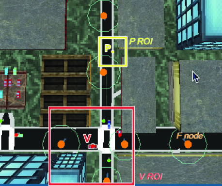
The aim of each node is to collect information associated to a given set of tiles that determine its Region of Interest (ROI). For the sake of simplicity a ROI is identified with a square centered around a given target location. ROIs positions may be static or dynamic in both space and time. In Figure 1 two ROIs are shown as squares of different dimensions centered around a pedestrian and a car, respectively.
Each node aims at maximizing the knowledge of the information associated with its ROI, constrained by the size of the memory (that we denote as ) that has been allocated to the purpose. To allow complete coverage of the ROI we must assume that .
3.1 Data exchange strategies
Every node can complete its task, i.e. to collect the maximum amount of information associated with the ROI, either by directly reading an interesting item from the environment, or by overhearing the same piece of information from the broadcast transmissions of other nodes. The former case occurs when a node hits an interesting location thanks to its mobility. The latter case is more interesting to model and investigate, being dependent on the mobility of all nodes in the system and the policies they adopt to collect, share, and broadcast the information stored in their memory.
In our analysis we assume that the time is slotted. In each time slot a node acquires the information corresponding to its current position (if it is not already contained in ). Moreover, each node can use a simple and random broadcasting policy to propagate its own information to its neighborhood. In particular, a node can randomly selects information items stored in its local memory and propagate them. The nodes adopt broadcasting policies aiming at limiting power consumption and at the same time avoiding to clutter the shared radio spectrum. To this end, broadcasting is activated only once every time slots; moreover, we investigate context aware approaches, e.g., a mobile node starts broadcasting only when it enters a new area, trying to maximize the information diffusion.
Different buffer management strategies have been considered. The basic policy is based on First In First Out (FIFO) buffer management. With this strategy each received piece of information is buffered with a FIFO policy if no information about the position has been included yet; on the contrary, if is stored in the node buffer with then, the corresponding record is updated. The basic configuration is compared with two simple improvements, referred in the following as selective dropping (SD) and selective insertion (SI), that aim at prioritizing the storage of those information items that are likely to fall within the ROI. According to SD the items can be popped out of memory only if they refer to a location outside the node’s ROI. Similarly, the SI prevents from storing any data outside the node ROI. In [7] we found that SI buffer management strategy was better than SD.
The performance index we are interested in is represented by the percentage of ROI covered by the items stored in the local buffer of each node. In the following we will refer to such percentage as coverage (). The value of the coverage clearly varies from node to node and it is time dependent. Furthermore, some subareas of the urban scenario are not accessible to nodes, e.g., due to some physical obstacle, therefore is computed as the number of items in the local buffer over the total number of accessible elements in the node ROI. Finally, if the environmental information changes with time only the most up-to-date elements are used for the computation of the ROI coverage.
4 Simulation methodology
In our investigation we evaluate the impact of a realistic 3D environment where pedestrian and cars co-exist in a typical urban scenario; to this end, we adopt the precise mobility simulator UDelModels [18]. UDelModels are a set of tools developed to model urban mesh networks that emulates both the mobility and the radio signal attenuation between any two nodes. UDelModels simulate the mobility of P and V nodes in a 3D space exploiting statistical studies of population and traffic dynamics. In UdelModels the number of nodes in the different classes and the statistical parameters of the mobility model can be properly configured. Pedestrians exhibit a motion that is representative of people in an urban scenario, with different mobility distributions for outside and inside walking, respectively. Moreover, a typical daily human activity cycle is taken into account. Cars mobility patterns take into account speed limits and traffic lights.
The UDelModels propagation [32] simulator is used to estimate the point to point attenuation between each pair of nodes in the 3D space. The channel loss is used to model the radio contacts among the communicating nodes. Any two nodes are assumed to be able to communicate to each other if the channel loss is below a threshold (in all our experiments was fixed to dB ).
The UDelModels results are used as input to a C++ simulator we developed whose major functionalities are:
-
•
to simulate the radio contacts among the nodes as far as the channel loss is below a threshold ;
-
•
to implement the management of the nodes buffer;
-
•
to simulate broadcast;
-
•
to implement different strategies for energy saving based on transmission delays and context awareness;
-
•
to simulate the E nodes;
-
•
to estimate the system performance in terms of the coverage of the nodes ROI.
4.1 Modeling assumption
In our simulation we do not explicitly consider collisions among concurrent transmissions of nearby nodes. We argue that this approximation is acceptable based on the following reasoning: assume that transmitters share a wireless channel whose capacity is b/s. Each transmitter has bits to transmit in one transmission that may occur at any point in time in an interval of seconds. Transmission of bits requires seconds to complete. Clearly, the probability of two colliding transmissions is equal to . A more accurate expression can be obtained by considering border effects that show up if transmissions of either nodes start within the first or the last seconds in the time interval of length : in this case we obtain . We can now derive the probability that transmitters do not collide as . In our settings, we assume that the relevant information regarding node coordinates and time stamps (which can be extracted from GPS records) plus the size of the data items requires 30 bytes to be stored. Since we consider transmissions of data items we obtain bits to be broadcast once every seconds (see Table 1). We observed that the average number of potentially colliding nodes in all our simulations has been . If we assume a Mb/s channel we obtain which is rather high and confirms that neglecting collision phenomena represents an acceptable approximations.
5 Results
In this section we evaluate the performance of content dissemination to metropolitan mobile users under several scenarios. First of all Section 5.1 describes the system settings that are common to all experiments. In Section 5.2 we evaluate the impact of policies aimed at reducing the overall number of transmissions for energy-saving purposes when information is dynamic, in Section 5.3 we analyze how performance is improved for indoor users when elevators are equipped with terminals able to relay data items. Finally, in Section 5.4 we analyze coverage for several models of ROI.
5.1 System settings
We consider a metropolitan area whose size is 550 m 500 m, representing 9 blocks of Chicago111The map data are available at http://udelmodels.eecis.udel.edu/. The 3D world is partitioned into flat square tiles whose side is m and each tile is associated to a piece of information. The size of the ROI depends on the node class, with and m for F, V and P nodes, respectively. In practice we assume that V nodes are interested in a larger area with respect to P nodes because of their larger speed. F nodes have the largest ROI since we assume that there are no strict constraints on the memory of the fixed infrastructure.
The memory constraint of each node is equal to the overall number of pieces of information in the node ROI, i.e. . Following the results obtained in [7] the memory policy is SI/SD for both information sensing and communication. The duration of one time slot is equal to 0.2 second and each node transmits once every seconds. Each transmission involves the fully random selection of data items in its buffer.
The fixed wireless infrastructure comprises F nodes placed at road intersections and building entrances; the population we consider comprises P nodes and V nodes. The mobility of V and P nodes is simulated with UDelModels with the speed of V nodes in the range km/h whereas the speed of P nodes is in the range km/h. Furthemore, the number of people and vehicles effectively present in the simulated area at different times of the simulation is determined by UDelModels. The channel loss is used to model the radio contacts among the communicating nodes; any two nodes are assumed to be able to communicate with each other if the channel loss is below a threshold that in all our experiments was fixed to dB.
The simulations are worked out in the time interval between 7 and 10 a.m. and the initial minutes are always considered as transient and therefore excluded from the computation of the average coverage . All the common system settings are summarized in Table 1.
| Parameter | Value | ||
|---|---|---|---|
| Simulated area | 550 m 500 m | ||
| 25 m | |||
| 5 | |||
| 0.2 s | |||
| -30 dB | |||
| Simulated time | from 7 to 10 a.m | ||
| Confidence interval | 0.95 | ||
| F nodes | V nodes | P nodes | |
| (in m) | 400 | 200 | 100 |
| population | 54 | 50 | 200 |
| speed (in Km/h) | 0 | ||
| communication | sensing | ||
| Memory policy | SI/SD | SI/SD | |
5.2 Information dynamics and energy savings
The simplest policy that can be devised for reducing the overall number of transmissions (hence the overall energy consumption) is to increase the time between successive transmissions of each P node. To this end we consider increasing delays between transmissions; namely we analyze the average coverage for seconds. The value represents the extreme case when P nodes never transmit, i.e. they do not participate to the spreading of information; it represents a lower bound on the achievable performance. The analysis is carried out when information does not vary in time (the scenario is called static) as well as when one randomly chosen information item is updated once every seconds. Some simulations based on this simple policy are already exploited in the static scenario in [8].
Figure 2 shows the average coverage for different values of and for increasing delays between successive transmissions of pedestrians. Frequent information updates negatively impact on the average coverage of both pedestrians and vehicles. Pedestrians are able to sustain 1 update every 30 seconds with an acceptable performance reduction. Vehicles are much more resilient to information change and are able to efficiently cope with updates that occur once every 10 seconds. In Table 2 we have reported the overall number of transmissions for P nodes as a function of (first row). It can be noted that for seconds there is one order of magnitude less transmissions and for seconds the savings is two orders of magnitude.


We also devised more complex transmission policies. In particular, we leveraged the UDel Models capabilities of tracking the status of a node in the mobility traces; an attribute (called floor) is assigned to each node to classify its current position. The floor attribute for a P node can be set to a code to represent any of the following cases:
-
•
inside, the floor number a node is on;
-
•
outside simulated area;
-
•
walking outside;
-
•
driving in car;
-
•
in parking lot;
-
•
in subway station.
In practical deployments this context information can be obtained by the ever growing number of sensors being embedded in modern mobile phones, e.g., pressure, gyroscope, along with localization services provided by GPS, wifi and mobile networks. This context information can be exploited to improve the information diffusion, taking into account the fact that it is very unlikely to get a radio contact between two terminals separated by a building element, e.g. one node walking outside and one sitting inside a building, or two nodes laying in separate floors of the same building. According to this rationale it comes in useful to force a node to spread the collected information as soon as its context changes, i.e. it is moving outside, inside or changing the floor, since it is very likely to contact novel nodes (unreachable in its previous context) increasing the probability to exchange fresh data. As a consequence we have devised the following context aware transmission policies:
-
•
floor(): whenever a P node changes the value of the floor attribute the device wakes up for seconds and transmits once every seconds;
-
•
walk(): whenever a P node leaves or enters the walking outside state, e.g. whether it exits/enters a building or stops driving, it wakes up for seconds and transmits once every seconds;
In the following experiment context awareness has been used in conjunction with previous approach based limiting the transmission opportunity. In Figure 3 we show the average coverage for P and V nodes when P nodes are allowed to transmit according to floor(), with s and s respectively, and at least once every s. It can be noted that, as we predict, there is an improvement of the average coverage for both P and V nodes for both static and dynamic information due to a better exploitation of P nodes mobility. In Table 2 the overall number of P nodes transmissions (per simulated scenario) is shown along with the additional number of transmissions performed according to the context aware policies; it can be noted that walk(1) requires the lowest number of additional transmissions. On the other hand, Figure 3 shows that floor(1) achieves the best coverage.
Finally, Figure 4 shows the comparison between floor(1) and walk(1) policies; although results in Table 2 clearly prove that the walk(1) policy can achieve a very small amount of transmissions for P nodes the gain in the average value of the coverage is negligible with respect to simply delaying successive transmissions.
| T=0.2 | T=10 | T=60 | T=600 | T= | |
| Reference scenario | 7000000 | 140000 | 23000 | 2300 | 0 |
| Additional transmissions | |||||
| floor(1) | 6700 | ||||
| floor(0.2) | 1340 | ||||
| walk(1) | 260 | ||||


5.3 Enhancing the building infrastructure
As we noted in the previous section, context awareness (implemented as additional transmission of P nodes based on the floor(w) and walk(w) policies) proved to be beneficial: there is an improvement of the average coverage for both P and V nodes for both static and dynamic information due to a better exploitation of P nodes mobility. These two policies rely on spontaneous nodes movements and context changing without the need of an extra infrastructure.
Nevertheless, we could improve the coverage of nodes by devising a simple solution based on elevators equipped with terminals able to relay data items. These terminals can be thought of as semi-fixed since their mobility is constrained to a vertical movement. We model the elevator mobility by means of two parameters: the average stopping time at a floor (60 seconds in our experiments) and the elevator speed (one floor per second). Every time an elevator moves it changes floor by choosing a destination uniformly at random among all floors of the building. Furthermore, their channel loss threshold was fixed to dB.
In Table 3 we show the average coverage of P and V nodes for dynamic information () in the reference scenario. We also show the case of delayed transmissions () with and without the use of the floor(1) policy. It can be noted that E nodes allow the average coverage of both node types to increase in all cases. Indeed, when E nodes hold on at the lower floors of a building are able to collect information carried by V and P nodes passing close to the outer walls. These nodes hold data items that belong to the ROI of P nodes inside the building and vice-versa; in this case, E nodes act as trait d’union among P nodes inside the building and the surrounding external environment. Additionally, E nodes spread this information to all P nodes laying in upper floors as soon as they move up and down. In this case, E nodes act as trait d’union among P nodes laying at different floors of the same building. The key role of E nodes is further highlighted in Table 3 where it is shown that short average waiting times at a floor translate into higher average coverage of P and V nodes.
| no E nodes | =180 | =120 | =60 | =15 | =5 | |
| P nodes | ||||||
| delayed | 0.40 | 0.50 | 0.51 | 0.55 | 0.61 | 0.63 |
| delayed + floor(1) | 0.44 | 0.54 | 0.55 | 0.58 | 0.63 | 0.66 |
| reference scenario | 0.48 | 0.59 | 0.60 | 0.64 | 0.70 | 0.73 |
| V nodes | ||||||
| delayed | 0.53 | 0.64 | 0.64 | 0.66 | 0.67 | 0.68 |
| delayed + floor(1) | 0.56 | 0.67 | 0.67 | 0.68 | 0.70 | 0.71 |
| reference scenario | 0.61 | 0.72 | 0.72 | 0.75 | 0.77 | 0.78 |
5.4 ROI dynamics
In all previous analysis we assume that every node is interested in retrieving the information located around its own position. As a consequence, the ROI has been linked with node position. In the following, this constraint will be removed letting the nodes pick up a random ROI according to several models. Table 4 compares the coverage obtained by P and V nodes in several scenarios varying the ROI model, the caching policies and transmission frequency. In particular, the results obtained in the reference scenario with a linked ROI are compared with those worked out when nodes let their ROIs floating according to the following model: every 10 minutes a node selects the ROI corresponding to its instantaneous position, then the node moves according to the mobility model without updating the ROI location. The first two sets of experiments in Table 4 investigate the effects of the selective insert (SI) policy in the static scenario (). In particular, we investigate the effect of using SI when reading a piece of information from the environment, i.e. associated to the node position. It can be noted that using SI when the ROI location does not coincide with the node position can be very critical, because it represents an egoistic behavior where data items that are not useful (in terms of ROI) for a node are not acquired and shared in the opportunistic network. This conjecture is confirmed by the simulations, where we notice a slight improvements in terms of coverage for the floating ROI in the case not using SI for environment sensing. As a consequence, SI is not used in all the remaining results of Table 4, where we analyze the performance when the information is updated with s, delayed transmissions () and when elevators are used to help spreading the data. The simulation results show that the proposed approaches are effective also for the floating ROIs. In particular, for P nodes we report very limited differences with respect to the case of linked ROIs. This is due to the fact that P nodes mobility within 10 minute is limited, thus the linked and floating ROI models are quite similar in practice. On the other hand, V nodes significantly improve their coverage in the case of floating ROI. Indeed, fixing the ROI for 10 minutes, makes it easier for faster V nodes to collect the items of interest because these are kept constant for a certain period.
| scenario | C for P nodes | C for V nodes | ||||
|---|---|---|---|---|---|---|
| l-ROI | f-ROI | l-ROI | f-ROI | |||
| , with SI | 200 | 50 | 0.62 | 0.62 | 0.71 | 0.73 |
| 500 | 0 | 0.62 | 0.62 | - | - | |
| , no SI | 200 | 50 | 0.62 | 0.66 | 0.71 | 0.81 |
| 500 | 0 | 0.62 | 0.66 | - | - | |
| s, no SI | 200 | 50 | 0.49 | 0.47 | 0.62 | 0.72 |
| 500 | 0 | 0.51 | 0.48 | - | - | |
| , no SI, delayed | 200 | 50 | 0.54 | 0.59 | 0.62 | 0.73 |
| 500 | 0 | 0.53 | 0.57 | - | - | |
| s, no SI, delayed | 200 | 50 | 0.41 | 0.40 | 0.53 | 0.65 |
| 500 | 0 | 0.40 | 0.39 | - | - | |
| , no SI, E nodes | 200 | 50 | 0.80 | 0.84 | 0.86 | 0.91 |
| 500 | 0 | 0.79 | 0.81 | - | - | |
| s, no SI, E nodes | 200 | 50 | 0.64 | 0.60 | 0.74 | 0.81 |
| 500 | 0 | 0.65 | 0.61 | - | - | |
Finally, a static ROI model has been simulated, where all nodes randomly select one out of static ROIs, with a given time frequency. In Table 5 the coverage obtained in the limit case of , i.e. same area of interest for all nodes, is shown. In particular, we show the sensitiveness of with respect to the position of the ROI inside and outside the buildings, respectively. It can be noted that P nodes are more effective in collecting information inside buildings, where the density of P nodes is higher. On the contrary, the V nodes coverage improves when the area of interest is located outside.
| C for P nodes | C for V nodes | |||
|---|---|---|---|---|
| out | in | out | in | |
| reference | 0.55 | 0.70 | 0.89 | 0.55 |
| with E nodes | 0.65 | 0.87 | 0.92 | 0.86 |
In presence of ROI dynamics it is very interesting to analyze the temporal behavior of the coverage. To this end, we define the performance index that represents the fraction of nodes of class having at time . In Figure 5 we show , i.e. the percentage of P nodes with as a function of . This plots allow one to appreciate the distribution of the values of of the P nodes. Figure 5 refers to the the reference scenario with static information (). The top-left figure is worked out in the case of a single ROI being updated randomly every 1 hour, synchronously by all nodes. The synchronous update is used as a limit case where all nodes change their interests at the same time and allow us to appreciate the worst case delays in the propagation of the information. As a consequence, in the plot the three transient behaviors due to the synchronous updates turns to be evident. The top-right figure refers to the same synchronous ROI update experiment when increasing the number of ROIs to ; it can be observed that nodes coverage reduces when increases. The positive effects yielded by the exploitation of nodes is shown in the third figure (bottom-left), where the coverage distribution is highly improved in the case . Finally, in the bottom-right part of Figure 5 we show the coverage distribution when all nodes randomly updates their ROIs every hour in an asynchronous fashion. In this latter case, every node picks up a random ROI and keeps it fixed for a random period uniformly distributed between 50 and 70 minutes.


6 Conclusions
We analyzed the performance of the system by defining the node coverage, i.e., the percentage of the ROI covered by the updated items stored in the memory of each node. We carried on a simulative study to investigate the detailed mobility and radio propagation traces generated by the UDelModels tools to estimate this performance index for all nodes types. The main findings are:
-
•
lowering the transmission rate of devices operated by pedestrians is an effective strategy for energy savings without significant coverage reduction even under information dynamics;
-
•
adding context awareness strategies further improves the results;
-
•
coverage of all nodes types can be increased by providing buildings with an infrastructure of relaying nodes mounted on elevators;
-
•
coverage of nodes increases when nodes share the same (few) ROIs that remain fixed for longer periods of time.
The current work may be extended in several ways: we are considering the impact of coding techniques [22] on the coverage of nodes as well as the use of compressive sensing [9, 4] concepts for sparsely defined information items. Finally, we are currently exploring the research area on spatio-temporal databases [6] to import ideas and techniques to improve our work.
Acknowledgement
I would like to thank Professors Gaeta Rossano, Grangetto Marco and Sereno Matteo for their expert advice and all the Computer Science Department of the University of Turin for their invaluable support.
References
- [1] M. Aly, A. Gopalan, J. Zhao, and A. Youssef. STDCS: A spatio-temporal data-centric storage scheme for real-time sensornet applications. SECON, pages 377–385, June 2008.
- [2] L. Atzori, A. Iera, and G. Morabito. The Internet of Things: A survey. Computer Networks, 54(15):2787 – 2805, 2010.
- [3] C. Avin, Y. Lando, and Z. Lotker. Simple random walks on radio networks (simple random walks on hyper-graphs). Arxiv preprint arXiv:0907.1678, 2009.
- [4] E. Candes and T. Tao. Near-optimal signal recovery from random projections: Universal encoding strategies? IEEE Transactions on Information Theory, 52(12):5406–5425, 2006.
- [5] A. A. V. Castro, G. D. M. Serugendo, and D. Konstantas. Hovering information–self-organizing information that finds its own storage. In Autonomic Communication, pages 111–145. Springer, 2009.
- [6] Y.-J. Choi and C.-W. Chung. Selectivity estimation for spatio-temporal queries to moving objects. In Proceedings of the ACM international conference on Management of data, SIGMOD, pages 440–451, 2002.
- [7] G. Corrente, R. Gaeta, M. Grangetto, and M. Sereno. Local data gathering using opportunistic networking in a urban scenario. In Proceedings of the 8th ACM PE-WASUN, 2011.
- [8] G. Corrente, R. Gaeta, M. Grangetto, and M. Sereno. Collaborative data retrieval using opportunistic networking. In 2012 9th Annual Conference on Wireless On-Demand Network Systems and Services (WONS), pages 139–142, 2012.
- [9] D. Donoho. Compressed sensing. Information Theory, IEEE Transactions on, 52(4):1289–1306, 2006.
- [10] M. Fiore, F. Mininni, C. Casetti, and C. Chiasserini. To cache or not to cache? In IEEE INFOCOM, pages 235–243, 2009.
- [11] M. Garetto, P. Giaccone, and E. Leonardi. On the capacity of ad hoc wireless networks under general node mobility. In INFOCOM . 26th IEEE International Conference on Computer Communications, pages 357–365, 2007.
- [12] T.-K. Huang, C.-K. Lee, and L.-J. Chen. Prophet+: An adaptive prophet-based routing protocol for opportunistic network. In Advanced Information Networking and Applications (AINA), 2010 24th IEEE International Conference on, pages 112 –119, 2010.
- [13] S. Iranmanesh. A novel queue management policy for delay-tolerant networks. EURASIP Journal on Wireless Communications and Networking, 2016(1):1, 2016.
- [14] P. Jacquet, B. Mans, and G. Rodolakis. Information propagation speed in mobile and delay tolerant networks. Information Theory, IEEE Transactions on, 56(10):5001–5015, 2010.
- [15] S. Jain, R. C. Shah, W. Brunette, G. Borriello, and S. Roy. Exploiting mobility for energy efficient data collection in wireless sensor networks. Mobile Network and Applications, 11(3):327–339, 2006.
- [16] P. Juang, H. Oki, Y. Wang, M. Martonosi, L. S. Peh, and D. Rubenstein. Energy-efficient computing for wildlife tracking: design tradeoffs and early experiences with zebranet. SIGOPS Oper. Syst. Rev., 36(5):96–107, 2002.
- [17] A. Keranen, M. Pitkanen, M. Vuori, and J. Ott. Effect of non-cooperative nodes in mobile dtns. In World of Wireless, Mobile and Multimedia Networks (WoWMoM), 2011 IEEE International Symposium on a, pages 1 –7, 2011.
- [18] J. Kim, V. Sridhara, and S. Bohacek. Realistic Mobility simulation of urban mesh network. Ad Hoc Networks, 7(2):411–430, 2009.
- [19] F. Kuhn and R. Oshman. Dynamic networks: models and algorithms. ACM SIGACT News, 42(1):82–96, 2011.
- [20] J. Leguay, A. Lindgren, J. Scott, T. Friedman, and J. Crowcroft. Opportunistic content distribution in an urban setting. In Proceedings of the 2006 SIGCOMM workshop on Challenged networks, pages 205–212, 2006.
- [21] A. Lindgren, A. Doria, and O. Schelen. Probabilistic routing in intermittently connected networks. In SIGMOBILE Mobile Computing and Communication Review, 2004.
- [22] M. Luby, M. Mitzenmacher, M. Shokrollahi, and D. Spielman. Efficient erasure correcting codes. Information Theory, IEEE Transactions on, 47(2):569–584, 2001.
- [23] H. Morcos, G. Atia, A. Bestavros, and I. Matta. An information-theoretic framework for field monitoring using autonomously mobile sensors. Ad Hoc Networks, 9(6):1049 – 1058, 2011.
- [24] H. Morcos, A. Bestavros, and I. Matta. Amorphous placement and informed diffusion for timely field monitoring by autonomous, resource-constrained, mobile sensors. In 5th Annual IEEE Communications Society Conference on Sensor, Mesh and Ad Hoc Communications and Networks, pages 469–477, 2008.
- [25] J. Ott, E. Hyytia, P. Lassila, T. Vaegs, and J. Kangasharju. Floating content: Information sharing in urban areas. In Pervasive Computing and Communications (PerCom), 2011 IEEE International Conference on, pages 136–146. IEEE, 2011.
- [26] F. Palmieri. Scalable service discovery in ubiquitous and pervasive computing architectures: A percolation-driven approach. Future Generation Computer Systems, 29(3):693–703, 2013.
- [27] F. Palmieri. Bayesian resource discovery in infrastructure-less networks. Information Sciences, 376:95–109, 2017.
- [28] A. Pettarin, A. Pietracaprina, G. Pucci, and E. Upfal. Tight bounds on information dissemination in sparse mobile networks. In 30th Annual ACM SIGACT-SIGOPS Symposium on Principles of Distributed Computing, 2011.
- [29] G. Resta and P. Santi. The effects of node cooperation level on routing performance in delay tolerant networks. In IEEE SECON, pages 413–421, 2009.
- [30] A. Sarwate and A. Dimakis. The impact of mobility on gossip algorithms. In IEEE INFOCOM, pages 2088–2096, 2009.
- [31] T. Small and Z. J. Haas. The shared wireless infostation model: a new ad hoc networking paradigm (or where there is a whale, there is a way). In Proceedings of the 4th ACM international symposium on Mobile ad hoc networking & computing, MobiHoc ’03, pages 233–244. ACM, 2003.
- [32] V. Sridhara and S. Bohacek. Realistic propagation simulation of urban mesh networks. Computer Networks: The International Journal of Computer and Telecommunications Networking, 51(12):3392–3412, 2007.
- [33] N. Thompson, R. Crepaldi, and R. Kravets. Locus: A location-based data overlay for disruption-tolerant networks. In Proceedings of the 5th ACM workshop on Challenged networks, pages 47–54. ACM, 2010.
- [34] E. Wang, Y. Yang, and J. Wu. A knapsack-based buffer management strategy for delay-tolerant networks. Journal of Parallel and Distributed Computing, 86:1–15, 2015.
- [35] D. Zhao, H. Ma, and L. Liu. Energy-efficient opportunistic coverage for people-centric urban sensing. Wireless Networks, pages 1–16, 2014.