Heterogeneous impact of a lockdown on inter-municipality mobility
Abstract
Without a vaccine, the fight against the spreading of the coronavirus has focused on maintaining physical distance. To study the impact of such measures on inter-municipality traffic, we analyze a mobile dataset with the daily flow of people in Portugal in March and April 2020. We find that the reduction in inter-municipality traffic depends strongly on its initial outflow. In municipalities where the mobility is low, the outflow reduced by and this decrease was independent of the population size. Whereas, for municipalities of high mobility, the reduction was a monotonic increasing function of the population size and it even exceeded for the largest municipalities. As a consequence of such heterogeneities, there were significant structural changes on the most probable paths for the spreading of the virus, which must be considered when modeling the impact of control measures.
I Introduction
In response to the coronavirus pandemics, many governments have imposed lockdowns, closing several public places, such as, schools, restaurants, sport centers, and shopping malls Hale et al. (2020). Companies and public services have opted for giving employees the choice to work from home Brynjolfsson et al. (2020). These non-pharmacological interventions are believed to be responsible for a significant slowdown of the spreading in different countries Maier and Brockmann (2020); Zhang et al. (2020); Kraemer et al. (2020); Buckee et al. (2020); Remuzzi and Remuzzi (2020); Giordano et al. (2020); Tian et al. (2020); Salje et al. (2020). However, one still lacks an understanding on how the mobility patterns have changed and how such changes affect the most probable pathways for the spread of the virus.
With digitalization and advancements in global data collection, the public expectations for knowledge-based strategies to control the spreading of the coronavirus have been high. Daily, the public is swamped with statistics about new infections, deaths, and recoveries around the world Dong et al. (2020); Times . Models and metrics are being proposed and further developed to turn data into actionable insights y Piontti et al. (2018). But, statistics of demographic variations of the impact of a virus are not enough. An extensive body of research on recent public health threats, such as the 2013 MERS-CoV, 2014 Ebola, and 2016 Zika viruses, has shown that to estimate the spread and implement efficient actions for controlling it, one needs to rigorously investigate the mobility patterns Halloran et al. (2014); Wesolowski et al. (2014); Poletto et al. (2014); Bogoch et al. (2016). Depending on the level of granularity, mobility data might be obtained from civil aviation statistics Woolley-Meza et al. (2011); Barbosa et al. (2018), national censuses Barbosa et al. (2018); Gonzalez et al. (2008), public transit ridership Ponte et al. (2018); Caminha et al. (2017); Verma et al. (2020), or mobile phone tracking Tizzoni et al. (2014); Gonzalez et al. (2008). By May 2020, there were more than k travel restrictions issued around the world to control inter- and intra-country travelling DTM . The mobility patterns today are very different from the ones in February 2020 and these publicly available data sets are no longer representative.
Epidemic spreading is a network-driven process Pastor-Satorras et al. (2015); Gómez-Gardenes et al. (2018); Meloni et al. (2011); Tizzoni et al. (2014). To understand the complex spatiotemporal spreading dynamics, one needs to replace the traditional view based on geographical distance by a probabilistically motivated effective distance computed from the flux of people Brockmann and Helbing (2013). With such a change of paradigm, one can identify the set of most probable paths for the spreading of the virus and the relative arrival times of an epidemics, which are both independent of the epidemic parameters. Thus, the role of a municipality on the global dynamics depends on its daily flow and effective distance to other municipalities.
Here, we study this impact by analyzing mobile phone data for the inter-municipality daily flow of people in Portugal in March and April 2020. The first confirmed case of COVID-19 in Portugal was reported on March 2, 2020. Ten days later, the total number of cases added up to 78 and the government announced a first set of control measures, which included school closures from March 14 onward. With a total of 642 identified cases, on March 19, the government decided to declare the state of emergency to impose more drastic measures of mobility restriction and social distance. We show that, the impact of the different measures was neither instantaneous nor homogeneous throughout the country. It extended over several days and the relative impact was strongly dependent on the population size of the municipality. We also analyze how the changes in mobility impacted on the distances. We show that the effective distances changed differently for each municipality. The structure of the set of most probable paths and relative arrival times also changed, with a significant impact on the spreading dynamics.

II Results
We analyze a national-scale mobile dataset provided by NOS, a Portuguese telecommunication company. This dataset contains the daily number of people that moved within and between municipalities in Portugal in March and April 2020, obtained from the mobile recurrent usage of residents and non-residents (see Materials and Methods for further details). The non-residents are defined as users with a SIM card from a foreign mobile network. A user is registered in the dataset if they stay for, at least, 60 minutes within the boundaries of a municipality (see Materials and Methods for further details).
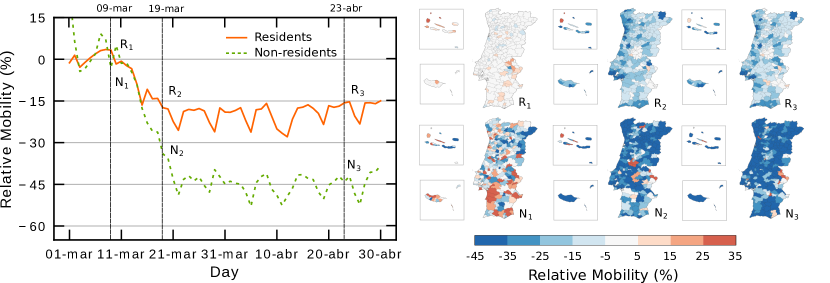
To quantify the inter-municipality mobility, we measure the daily number of users moving within and between municipalities and define relative mobility as this number rescaled by the average mobility from March 2 to 6 (baseline), which is a period before any control measure. In Fig. 1, we show the time dependence of the relative mobility averaged over all municipalities for residents and non–resident users. Even before the declaration of the state of emergency (March 18), with the first set of control measures (March 12), the mobility started to decrease. However, this change in mobility was not instantaneous, it occurred over several days and only reached a steady level after March 21, with a decrease of about for residents and for non–residents. The periodic structure observed in the steady regime corresponds to the expected weekday (Monday to Friday) and weekend (Saturday to Sunday) differences, with a clear decrease in mobility during the weekends. In the same figure, we show also the spatial distribution of the relative mobility for three different days (March 9, March 19, and April 23). One sees that, the impact of the control measures was heterogeneous throughout the country. To characterize these heterogeneities, in what follows, we analyze the inter–municipality mobility. Since only of the users are non-residents, for simplicity, we consider only the resident one.
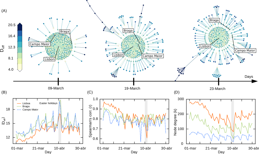
The origin–destination matrix (OD) is defined such that each element is the fraction of users that, in day , stayed for more than minutes in both municipalities and (see Materials and Methods). From the OD matrix, we obtain the mobility network, which is a weighted directed graph, where the nodes are the municipalities and the weight of the link is . Note that, in general, , as the total number of users in each municipality is different (see Materials and Methods for further details). The mobility network sets the stage for the propagation to other municipalities. As shown in Ref. Brockmann and Helbing (2013), further insight into the propagation dynamics is obtained from the mobility network if we compute the effective distance between nodes, defined as follows. For each pair of nodes and , we defined the length of the link as . Thus, the most probable path between two nodes is the shortest path between the two, defined as the one that minimizes the sum of all along the path. The effective distance is then the value of such sum Brockmann and Helbing (2013). For every municipality , we can obtain the shortest–path tree, consisting of the set of the most probable paths to all the other municipalities, where the central node is the origin . In Fig. 2, we show three examples of the shortest–path trees, for (A) Lisbon, (B) Braga, and (C) Campo Maior, using an OD matrix obtained from the average mobility from March 2 to 6. All nodes are placed at a distance from the central node proportional to their effective distance to it. For the sake of comparison, the color of a node is given by the geographic distance from the central node. The size of the node is given by the value of the betweenness centrality, which is defined as the number of shortest paths that go from the central node to any other node on the tree through that node. In the figure, below each tree, we also show a color map displaying the spatial distribution of effective distances from each center. It is clear that, some municipalities can be geographically far from the central municipality, but have a small value of effective distance, indicating that the relation between effective distances and geographic distances are non-trivial.
Since the change in mobility was heterogeneous throughout the country, as shown in Fig. 1, it is expected that both the effective distances and structure of the shortest–path trees have changed. To illustrate such changes, we show in Fig. 3(A) the time evolution of the shortest–path tree for Lisbon. We discover a change from a star-like structure to a more branched structure. Figure 3(B) shows the time evolution of the average effective distance to all other municipalities for Lisbon, Braga, and Campo Maior. With the lockdown, increased, consistent with a much slower propagation dynamics. The maximum on the Easter holidays (gray region) is reflective of a set of additional measures imposed by the Portuguese government for those days to avoid the traditional family gatherings, which included severe restrictions to the inter-municipality mobility. For each day , we calculated the Spearman’s correlation between the effective distance and the initial effective distance , obtained from the average mobility network from March 2 to 6 (before the lockdown). The Spearman’s correlation for the entire set of municipalities is defined as
| (1) |
where is the rank of , is the rank of , is the covariance of the rank, and is the standard deviation. An means that the rank of effective distances has not changed, while corresponds to a new rank that is uncorrelated from the original one. The daily evolution of is shown in Fig. 3(C). For the three municipalities, decreased with the lockdown. This result suggests that the hierarchical organization of municipalities in a spreading process was affected significantly by the lockdown.
Figure 3(D) depicts the evolution of the degree of the central node (Lisbon, Braga, and Campo Maior), corresponding to the number of municipalities that are directly connected to the central node in the shortest–path tree. Before the lockdown, Lisbon was connected by a single edge to of the municipalities. With the lockdown, Lisbon, in average, became only connected directly to of the municipalities. This is in line with a change from a star-like to a branched structure, as observed in Fig. 3(A). We see a similar behavior for Braga, starting with the fraction of municipalities connected directly, decreasing from to , and for Campo Maior, where the drop is from to .
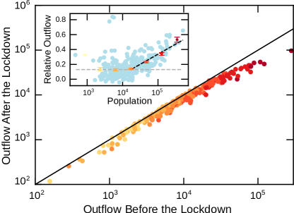
In Fig. 4, we compare the outflow before and after the lockdown. The outflow is defined as the total number of resident users of a municipality that were also identified in a different municipality during the day (see Materials and Methods). The values before the lockdown are averages from March 2 to 6 and after the lockdown from April 13 to 17. We find that, although the control measures were the same for the entire country, their impact on the outflow strongly depends on the initial value of the outflow. For municipalities with low values of outflow, we observe a linear relation between the outflows before and after, which suggests that the relative impact is the same. However, for the municipalities with higher values of the outflow, we observe a sublinear relation between the two. The larger the initial value of the outflow the stronger is the impact of the control measures. Since the outflow of a municipality correlates strongly with the population size Simini et al. (2012), in the inset of Fig. 4, we plot the relative decrease in outflow as a function of the population size. For municipalities with less than users, the outflow decreased by , without a clear dependence on the population size. Whereas, for larger municipalities, the relative decrease in the outflow scales logarithmically with the population size (dashed line) and it exceeds for the largest municipality (Lisbon).
III Conclusions
Human mobility sets the stage for global spreading phenomena Gómez-Gardenes et al. (2018); Guimera et al. (2005); Lee et al. (2017); Barbosa et al. (2018); Brockmann and Helbing (2013). Across the world, the most relevant non-pharmacological interventions to contain the spreading of the coronavirus have been related to closing borders and restricting the intra- and inter-country mobility, which has affected the mobility patterns Tian et al. (2020). Here, we studied the impact of such mobility restrictions in the inter-municipality flow of people in Portugal, in March and April of 2020. From a large dataset of mobile phone users, we obtained the origin–destination matrix and the shortest–path trees from all municipalities. These trees represent the most probable paths for the spreading of the virus, when starting from a given municipality Tizzoni et al. (2014); Brockmann and Helbing (2013); Piontti et al. (2014). We find that the relative decrease in mobility correlates with the population size of a municipality. For small municipalities, with less than mobile users, the outflow is decreased by about , regardless the size of the municipality. However, for larger municipalities, the relative decrease in the outflow depend strongly on the population size and it even exceeds for the largest municipalities. Such a heterogeneous change in mobility affects deeply the structure of the shortest–path trees and, therefore, the relative effective distance between municipalities.
To circumvent the absence of accurate data for mobility, models have been developed to artificially generate them, as for example the gravity and radiation models de Dios Ortúzar and Willumsen (2011); Simini et al. (2012), or to account for mobility restrictions in the models Arenas et al. (2020); Costa et al. (2020); Meloni et al. (2011). From our findings, it is now possible to extend these models to account for the dependence on the size and mobility of a municipality. This heterogeneous response is an important ingredient to consider in epidemic models, such as the ones developed in Refs. Arenas et al. (2020); Costa et al. (2020); Meloni et al. (2011); Wang and Li (2014); Hollingsworth et al. (2006); Cooper et al. (2006); Bajardi et al. (2011); Ferguson et al. (2006); Colizza et al. (2007); Wang et al. (2012), so that governments can respond to the spread more accurately.
IV Materials and Methods
IV.1 Mobility matrix from mobile phones records
The mobile data was obtained from NOS cellular network and its volume goes up to about 8 Terabytes of events, collected from the network interfaces in March and April 2020. Each record in the dataset refers to a unique subscriber id, General Data Protection Regulation (GDPR) compliant regarding Personal Identifiable Information (PII) GDP , and it includes the date/timestamp of each respective event and the geographic coordinates of the respective network cell coverage centroid where each event occurred. Such dataset can thus provide an abstraction of subscriber physical displacements over time.
The process to compute the mobility matrices is composed of several steps: from data event aggregation and location estimation to trip count aggregation. Within the data event aggregation part, the events are aggregated in a minutes sliding window with detection counts for each subscriber id performed by cell. The location for each subscriber id is estimated based on the most frequent cell algorithm. Once the location trips are extracted, the process to derive origin–destination flows between geographic areas is the following: i. The geographic area under analysis is divided into municipalities; ii. Origin and destination municipalities, together with starting time are extracted for each subscriber id. iii. Trips with the same origin, destination, and time frame are grouped together. The result is a matrix whose element represents the number of trips from origin to destination , starting within the time frame. Here, we used the municipal areas in Portugal for the regions and the time frame of 6 am and 8 pm.
From the mobility matrix, the extrapolation process is carried out to represent the whole universe of the population in study. The extrapolation algorithm takes into consideration local as well as international market shares, besides wholesale agreements between parties. After extrapolation, the transformation process takes place to extract features from residents and non–residents, segmenting the data between flows from region to , and the ones that do not move within that time window, which is the same as saying that is equal to . At the end, compliance with the data privacy rules (GDPR) are applied and trips with counts under 6 are omitted.
IV.2 Shortest–path trees
For the network analysis, we only considered the movement of residents, i.e., in the mobility matrix F(d), is the number of resident users who were identified at both municipality and within the day . In order to measure the combined number of individuals from to , we considered the undirected mobility network using the standard symmetrization operation , where is the transposed matrix of F Brockmann and Helbing (2013).
Each element of the origin–destination matrix P is calculated as , where the sum is over all municipalities, and quantifies the mobility network, where the nodes are the municipalities and the edges between and have a weight . If we define the distance for each edge, the most probable paths are the ones that minimize the total sum of Brockmann and Helbing (2013). For each node, one can define a shortest–path tree (see Fig. 2) and the effective distance from a node to as the length of the shortest path between these two nodes.
Acknowledgements.
We acknowledge financial support from the Portuguese Foundation for Science and Technology (FCT) under Contracts no. PTDC/FIS-MAC/28146/2017 (LISBOA-01-0145-FEDER-028146), UIDB/00618/2020 and UIDP/00618/2020, and from NOS SGPS S.A. for providing the mobile data.References
- Hale et al. (2020) T. Hale, A. Petherick, T. Phillips, and S. Webster, “Variation in government responses to covid-19,” Blavatnik school of government working paper BSG-WP-2020/032 (2020).
- Brynjolfsson et al. (2020) E. Brynjolfsson, J. J. Horton, A. Ozimek, D. Rock, G. Sharma, and H. TuYe, Covid-19 and remote work: An early look at us data, Tech. Rep. (National Bureau of Economic Research, 2020).
- Maier and Brockmann (2020) B. .F Maier and D. Brockmann, “Effective containment explains subexponential growth in recent confirmed covid-19 cases in china,” Science 368, 742–746 (2020).
- Zhang et al. (2020) J. Zhang, M. Litvinova, Y. Liang, Y. Wang, W. Wang, S. Zhao, Q. Wu, S. Merler, C. Viboud, A. Vespignani, et al., “Changes in contact patterns shape the dynamics of the covid-19 outbreak in china,” Science (2020).
- Kraemer et al. (2020) M. U. G. Kraemer, C. Yang, B. Gutierrez, C. Wu, B. Klein, D. M. Pigott, L. Du Plessis, N. R. Faria, R. Li, W. P. Hanage, et al., “The effect of human mobility and control measures on the covid-19 epidemic in china,” Science 368, 493–497 (2020).
- Buckee et al. (2020) C. O. Buckee, S. Balsari, J. Chan, M. Crosas, F. Dominici, U. Gasser, Y. H. Grad, B. Grenfell, M. E. Halloran, M. U. G. Kraemer, et al., “Aggregated mobility data could help fight covid-19.” Science 368, 145 (2020).
- Remuzzi and Remuzzi (2020) A. Remuzzi and G. Remuzzi, “Covid-19 and italy: what next?” The Lancet 395, 1225 – 1228 (2020).
- Giordano et al. (2020) G. Giordano, F. Blanchini, R. Bruno, P. Colaneri, A. Di Filippo, A. Di Matteo, and M. Colaneri, “Modelling the covid-19 epidemic and implementation of population-wide interventions in italy,” Nature Medicine , 1–6 (2020).
- Tian et al. (2020) H. Tian, Y. Liu, Y. Li, C. Wu, B. Chen, M. U. G. Kraemer, B. Li, J. Cai, B. Xu, Q. Yang, et al., “An investigation of transmission control measures during the first 50 days of the covid-19 epidemic in china,” Science 368, 638–642 (2020).
- Salje et al. (2020) H. Salje, C. Tran Kiem, N. Lefrancq, N. Courtejoie, P. Bosetti, J. Paireau, A. Andronico, N. Hozé, J. Richet, C. Dubost, et al., “Estimating the burden of sars-cov-2 in france,” Science (2020).
- Dong et al. (2020) E. Dong, H. Du, and L. Gardner, “An interactive web-based dashboard to track covid-19 in real time,” The Lancet infectious diseases 20, 533–534 (2020).
- (12) Financial Times, “Coronavirus tracked: the latest figures as countries fight to contain the pandemic, from: https://www.ft.com/content/a26fbf7e-48f8-11ea-aeb3-955839e06441. date of access 22 jun 2020.” .
- y Piontti et al. (2018) A. P. y Piontti, N. Perra, L. Rossi, N. Samay, and A. Vespignani, Charting the Next Pandemic: Modeling Infectious Disease Spreading in the Data Science Age (Springer, 2018).
- Halloran et al. (2014) M. E. Halloran, A. Vespignani, N. Bharti, L. R. Feldstein, K. A. Alexander, M. Ferrari, J. Shaman, J. M. Drake, T. Porco, J. N. S. Eisenberg, et al., “Ebola: mobility data,” Science 346, 433–433 (2014).
- Wesolowski et al. (2014) A. Wesolowski, C. O. Buckee, L. Bengtsson, E. Wetter, X. Lu, and A. J. Tatem, “Commentary: containing the ebola outbreak-the potential and challenge of mobile network data,” PLoS Currents 6 (2014).
- Poletto et al. (2014) C. Poletto, C. Pelat, D. Levy-Bruhl, Y. Yazdanpanah, P. Y. Boelle, and V. Colizza, “Assessment of the middle east respiratory syndrome coronavirus (mers-cov) epidemic in the middle east and risk of international spread using a novel maximum likelihood analysis approach,” Eurosurveillance, European Centre for Disease Prevention and Control 19, 3 (2014).
- Bogoch et al. (2016) I. I. Bogoch, O. J. Brady, M. U. G. Kraemer, M. German, M. I. Creatore, M. A. Kulkarni, J. S. Brownstein, S. R. Mekaru, S. I. Hay, E. Groot, et al., “Anticipating the international spread of zika virus from brazil,” The Lancet 387, 335–336 (2016).
- Woolley-Meza et al. (2011) O. Woolley-Meza, C. Thiemann, D. Grady, J. J. Lee, H. Seebens, B. Blasius, and D. Brockmann, “Complexity in human transportation networks: a comparative analysis of worldwide air transportation and global cargo-ship movements,” The European Physical Journal B 84, 589–600 (2011).
- Barbosa et al. (2018) H. Barbosa, M. Barthelemy, G. Ghoshal, C. R. James, M. Lenormand, T. Louail, R. Menezes, J. J. Ramasco, F. Simini, and M. Tomasini, “Human mobility: Models and applications,” Physics Reports 734, 1–74 (2018).
- Gonzalez et al. (2008) M. C. Gonzalez, C. A. Hidalgo, and A. Barabasi, “Understanding individual human mobility patterns,” Nature 453, 779–782 (2008).
- Ponte et al. (2018) C. Ponte, H. P. M. Melo, C. Caminha, J. S. Andrade, and V. Furtado, “Traveling heterogeneity in public transportation,” EPJ Data Science 7, 42 (2018).
- Caminha et al. (2017) C. Caminha, V. Furtado, T. H. C. Pequeno, C. Ponte, H. P. M. Melo, E. A. Oliveira, and J. S. Andrade, “Human mobility in large cities as a proxy for crime,” PloS One 12 (2017).
- Verma et al. (2020) T. Verma, M. Sirenko, I. Kornecki, S. Cunningham, and N. A. M. Araújo, “Extracting spatiotemporal demand for public transit from mobility data,” arXiv preprint arXiv:2006.03351 (2020).
- Tizzoni et al. (2014) M. Tizzoni, P. Bajardi, A. Decuyper, G. K. K. King, C. M. Schneider, V. Blondel, Z. Smoreda, M. C. González, and V. Colizza, “On the use of human mobility proxies for modeling epidemics,” PLoS Computational Biology 10 (2014).
- (25) The UN Migration Agency, DTM (COVID-19) Global Mobility Restriction Overview, 07 May 2020, https://dtm.iom.int/reports.
- Pastor-Satorras et al. (2015) R. Pastor-Satorras, C. Castellano, P. Van Mieghem, and A. Vespignani, “Epidemic processes in complex networks,” Reviews of modern physics 87, 925 (2015).
- Gómez-Gardenes et al. (2018) J. Gómez-Gardenes, D. Soriano-Panos, and A. Arenas, “Critical regimes driven by recurrent mobility patterns of reaction–diffusion processes in networks,” Nature Physics 14, 391–395 (2018).
- Meloni et al. (2011) S. Meloni, N. Perra, A. Arenas, S. Gómez, Y. Moreno, and A. Vespignani, “Modeling human mobility responses to the large-scale spreading of infectious diseases,” Scientific Reports 1, 62 (2011).
- Brockmann and Helbing (2013) D. Brockmann and D. Helbing, “The hidden geometry of complex, network-driven contagion phenomena,” Science 342, 1337–1342 (2013).
- Hu (2005) Y. Hu, “Efficient, high-quality force-directed graph drawing,” Mathematica Journal 10, 37–71 (2005).
- (31) Data set for the population of each municipality in Portugal in 2018, from https://www.pordata.pt/Tema/Municipios.
- Simini et al. (2012) F. Simini, M. C. González, A. Maritan, and A. Barabási, “A universal model for mobility and migration patterns,” Nature 484, 96–100 (2012).
- Guimera et al. (2005) R. Guimera, S. Mossa, A. Turtschi, and L. A. N. Amaral, “The worldwide air transportation network: Anomalous centrality, community structure, and cities’ global roles,” Proceedings of the National Academy of Sciences 102, 7794–7799 (2005).
- Lee et al. (2017) M. Lee, H. Barbosa, H. Youn, P. Holme, and G. Ghoshal, “Morphology of travel routes and the organization of cities,” Nature Communications 8, 1–10 (2017).
- Piontti et al. (2014) A. P. Y. Piontti, M. F. C. Gomes, N. Samay, N. Perra, and A. Vespignani, “The infection tree of global epidemics,” Network Science 2, 132–137 (2014).
- de Dios Ortúzar and Willumsen (2011) J. de Dios Ortúzar and L. G. Willumsen, Modelling transport (John wiley & sons, 2011).
- Arenas et al. (2020) A. Arenas, W. Cota, J. Gómez-Gardenes, S. Gómez, C. Granell, J. T. Matamalas, D. Soriano-Panos, and B. Steinegger, “A mathematical model for the spatiotemporal epidemic spreading of covid19,” medRxiv (2020).
- Costa et al. (2020) G. S Costa, W. Cota, and Silvio C. Ferreira, “Metapopulation modeling of covid-19 advancing into the countryside: an analysis of mitigation strategies for brazil,” medRxiv (2020).
- Wang and Li (2014) L. Wang and X. Li, “Spatial epidemiology of networked metapopulation: An overview,” Chinese Science Bulletin 59, 3511–3522 (2014).
- Hollingsworth et al. (2006) T. D. Hollingsworth, N. M. Ferguson, and R. M. Anderson, “Will travel restrictions control the international spread of pandemic influenza?” Nature medicine 12, 497–499 (2006).
- Cooper et al. (2006) B. S. Cooper, R. J. Pitman, W. J. Edmunds, and N. J. Gay, “Delaying the international spread of pandemic influenza,” PLoS Medicine 3 (2006).
- Bajardi et al. (2011) P. Bajardi, C. Poletto, J. J. Ramasco, M. Tizzoni, V. Colizza, and A. Vespignani, “Human mobility networks, travel restrictions, and the global spread of 2009 h1n1 pandemic,” PloS One 6 (2011).
- Ferguson et al. (2006) N. M. Ferguson, D. A. T. Cummings, C. Fraser, J. C. Cajka, P. C. Cooley, and D. S. Burke, “Strategies for mitigating an influenza pandemic,” Nature 442, 448–452 (2006).
- Colizza et al. (2007) V. Colizza, A. Barrat, M. Barthelemy, A. Valleron, and A. Vespignani, “Modeling the worldwide spread of pandemic influenza: baseline case and containment interventions,” PLoS Medicine 4 (2007).
- Wang et al. (2012) L. Wang, Y. Zhang, T. Huang, and X. Li, “Estimating the value of containment strategies in delaying the arrival time of an influenza pandemic: A case study of travel restriction and patient isolation,” Physical Review E 86, 032901 (2012).
- (46) EU General Data Protection Regulation (GDPR): Regulation (EU) 2016/679 of the European Parliament and of the Council of 27 April 2016 on the protection of natural persons with regard to the processing of personal data and on the free movement of such data, and repealing Directive 95/46/EC (General Data Protection Regulation), OJ 2016 L 119/1.