On the Potential of Smarter Multi-layer Maps
Abstract
The most common way for robots to handle environmental information is by using maps. At present, each kind of data is hosted on a separate map, which complicates planning because a robot attempting to perform a task needs to access and process information from many different maps. Also, most often correlation among the information contained in maps obtained from different sources is not evaluated or exploited.
In this paper, we argue that in robotics a shift from single-source maps to a multi-layer mapping formalism has the potential to revolutionize the way robots interact with knowledge about their environment. This observation stems from the raise in metric-semantic mapping research, but expands to include in its formulation also layers containing other information sources, e.g., people flow, room semantic, or environment topology. Such multi-layer maps, here named hypermaps, not only can ease processing spatial data information but they can bring added benefits arising from the interaction between maps. We imagine that a new research direction grounded in such multi-layer mapping formalism for robots can use artificial intelligence to process the information it stores to present to the robot task-specific information simplifying planning and bringing us one step closer to high-level reasoning in robots.
I Introduction
Environmental awareness is a crucial skill for robotic systems intended to autonomously navigate and interact with their surroundings. For indoor robots, 2D occupancy grid maps are often used as internal representation of the environment where a robot is navigating. These maps represent the world by using a grid of cells each containing the belief of the system over the occupancy of the area of the world corresponding to each cell. These maps are usually built automatically by using 2D laser scanners (lidars) mounted on the robot and are used for localization and path planning in the environment [1]. However, these maps suffer from many limitations, e.g., 2D lidars are not able to detect transparent obstacles such as glass, and are limited to measuring occupancy at a single height, incapable of inferring the true occupancy of complex objects such as tables [2]. These limitations can partially be addressed by moving to 3D maps, where a representation of the environment is built using 3D lidars or RGB-D cameras and maintained either as a mesh, point-cloud, or voxel grid [3]. However, while both these representations are able to effectively record the static components of an environment, their ability to represent its dynamic aspects is limited, e.g., representing the possibility of a door being either open or closed, objects changing position or people movement [4]. Also, these maps contain enough information for a robot to be able to navigate, but are insufficient for tasks requiring information other than environment traversability. For example, they do not host any semantic information about the environment, i.e., what the object and rooms in the environment are [5].
In the past few years, advances in computer vision and machine learning have increased the ability of autonomous agents to understand the world around them. In particular, semantic interpretation of sensor output is bringing improved reasoning capabilities and safety in applications like autonomous vehicles and indoor service robots [6, 7]. Consequentely, the number of techniques proposing to create maps that fuse this growing amount of richer information on metric maps is increasing [8, 9].
The ability for service robots to exploit these advancements is crucial for their widespread adoption, as their ability to have a deeper understanding of their environment will be required for them to solve everyday tasks, from interacting naturally with the user, to fetching objects in the environment.
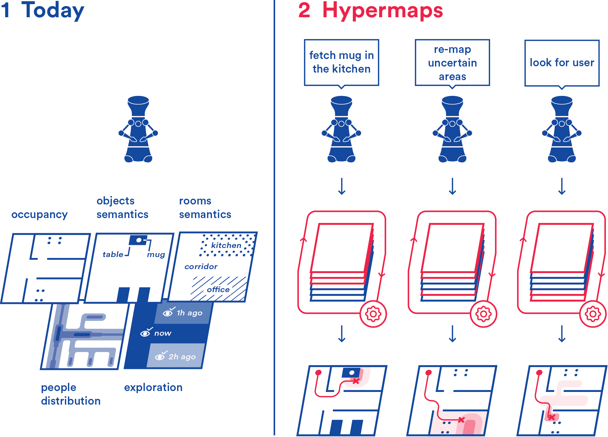
At the current state of technology, however, any new piece of information the robot needs to record about the environment is often stored in a separate map: an occupancy map for navigation, a semantic map for object localization, a map tracking people movement, and so on.
An example of these more high-level tasks is autonomous semantic exploration, where a robot’s task is to label objects in the environment it is in while autonomously navigating in it. To solve this task, the inteligent agent guiding the robot needs to maintain at least an occupancy map of the environment for navigation, an exploration map keeping track of which areas have already been visited, and a semantic map where locations and labels of objects in the environment are recorded.
Each of these maps usually has different implementations and is handled by the agent independently from the others. This approach has several shortcomings:
-
•
The agent needs to interact with the different map implementations, which as the number of maps required for advanced applications grows, can become a burden. This is particularly challenging for learning agents, for which richer and diverse inputs might complicate architecture design and training.
-
•
The automatic map generation algorithms used for populating these maps are prone to errors. This is most critical when maps are populated by state-of-the-art deep learning algorithms as most of the times these techniques provide point estimates and are unable to measure the confidence of their prediction.
-
•
Treating each map independently is suboptimal, as additional information could be extracted by observing the interaction and correlation amongst different maps.
Recent works are starting to combine semantic and metric information in single maps, by assigning a semantic label to each metric location in the environment [8, 9]. However, in this paper we argue that to address these shortcomings and exploit all the information maps provide, we need to go beyond semantic-metric maps. We argue that a paradigm shift from single-source maps to a multi-layer mapping formalization—which we will call an hypermap—is necessary. In such a framework, each different kind of map information is maintained in relationship with each other and, moreover, AI techniques could be used to extract additional knowledge arising from the layer’s relationships as well as to simplify the high-level agent’s interaction with the data stored in the maps. A graphical example of these interactions is shown in Fig. 1. In the rest of this article, we will discuss the benefits such a paradigm shift could bring to robot autonomy as well as possible interesting research directions that it would enable.
II Related works
While a literature on multi-layer mapping exists, it has so far mostly focused on hierarchical conceptual abstractions, where each layer captures properties of the environment at a different granularity: starting from metric, they extract connectivity graphs and environment topology, to finally construct a spatial ontology [11, 12]. However, the architectures proposed in those works rarely include multiple maps capturing the environment as seen by different sensor modalities but rather abstract the content of the metric map to facilitate reasoning and human-robot interaction [13]. While these are certainly caractheristics that should be preserved while building hypermaps, we argue that they are not suffient and that the modern advancements in computer vision and machine learning enable us to map a more varied array of properties of the environment, which might be obtained both from direct sensor reading and virtual AI-based sensors.
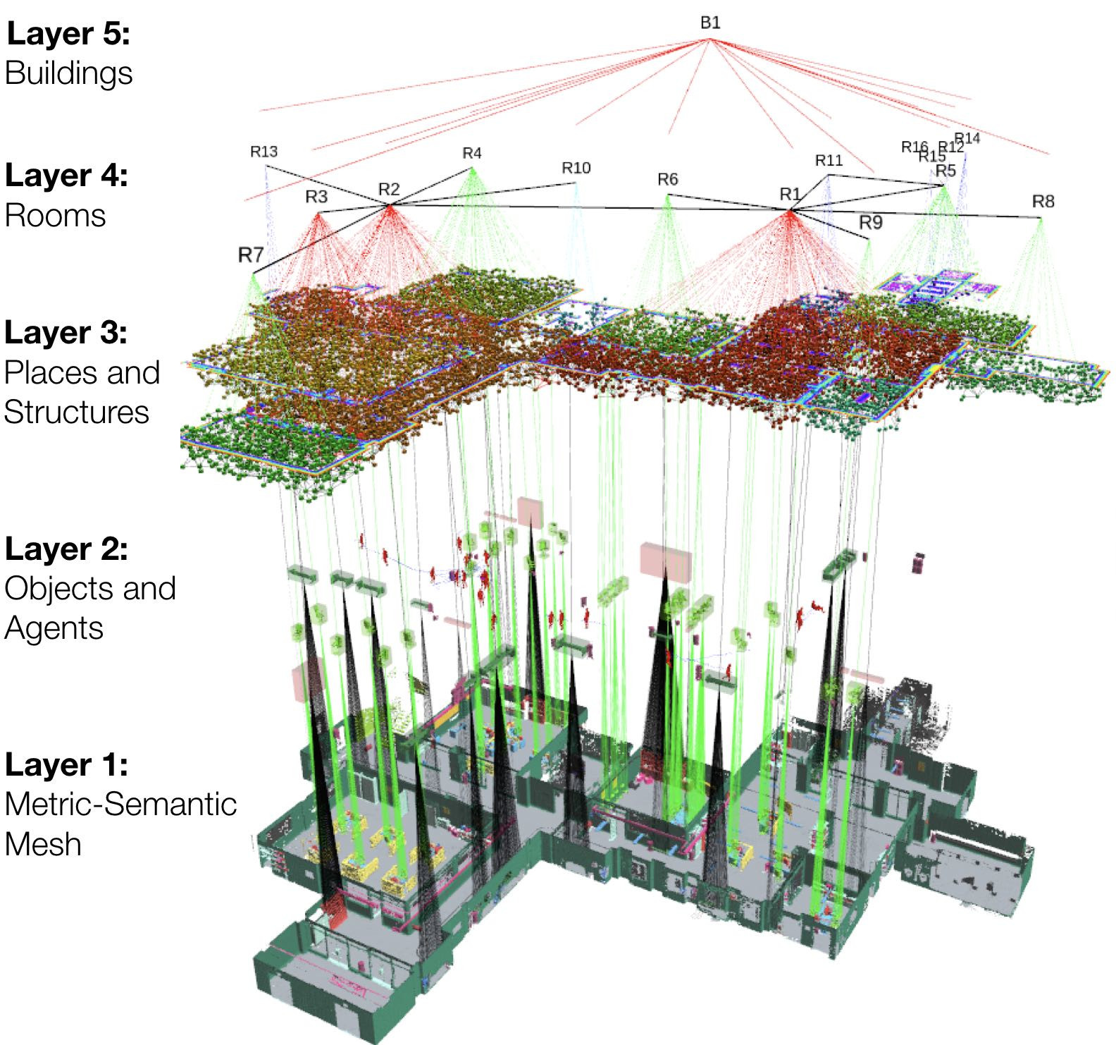
Recently, a couple of multi-layer mapping formalisms have been proposed that looked at including different sensor modalities. We proposed an early idea for 2D hypermaps in [14], where we present a multi-layer framework composed of a metric, semantic, and exploration layers, and demonstrate its application in the context of autonomous semantic exploration. Moreover, the very recent 3D multi-layer graph mapping approach proposed by Rosinol et al. [10], fits very well under the hypermap formalism. In that work, the authors develop a hierarchical graph (shown in Fig. 2) connecting the different map abstractions in each layer and demonstrate the ability of such a system to be used to simulate realistic dynamic environments. That map comprises 3D metric and semantic layers, an object layer where a mesh of each individual semantic entity is maintained in relationship to its position in the environment, as well as environment abstractions like topological and connectivity graphs.
III Proposed research directions
At its core, an hypermap centrilizes all the spatial knowledge available to the robot and maintains a network of relationships between different abstractions and representations of the environment. Once such a framework is in place, many interesting possibilities open. By maintaining a network of interactions between different layers, it is possible to correlate information obtained from different sources. To give some examples, this could enable us to study the following:
-
•
Anomaly detection and correction: errors in one layer could be noticed and corrected by looking at the interaction with other layers. Once anomalies are detected, an active strategy can be employed to re-map that portion of the environment to eventually correct the anomaly.
-
•
Multi-map knowledge extraction: many kinds of reasoning could benefit from being able to easily access information on multiple layers. As an example, occupancy of an area of the environment could be considered uncertain after a certain time if the area is marked on the semantic layer as a chair, as chairs tend to move. This semantics-based environment dynamics could be used to perform safer path planning by avoiding areas of high uncertainty.
-
•
Content estimation: when only a part of the environment has been mapped in a specific map, information from the other layers about the rest of the environment could be used to estimate what the map content is for the unexplored areas, exploiting correlation of the available part of the map.
-
•
Virtual planning layers: Aside for the layers populated by sensors (e.g., occupancy, temperature) and machine learning (e.g., semantic, people movement), new virtual layers could be populated combining information from different layers. These layers could be developed in such a way to be the ideal planning map for a specific task. As an example, to avoid glass walls, a layer combining information from the occupancy layer and people movement could be used for a robot to navigate in areas where humans navigate, assuming that, even if the robot does not see any obstacle, if no human has ever moved through that opening, it is probably impassable.
Some of these problems have parallels in other disciplines, so to tackle these open research directions, literature from these disciplines can be leveraged and bridged with the mapping literature. This includes for example, the literatures on anomaly detection in hyperspectral images [15, 16] and graph signal processing [17, 18].
IV Effects on high-level reasoning
At present, high-level planning involving robot mobility is often posed as a reinforcement learning (RL) problem where the robot learns a policy to perform a course of action that leads to the desired goal. The goal is usually tied to the completion of a task involving some degree of human understanding and environment navigation. RL-based solutions to these tasks frequently work without employing any map [19, 20] but rather they embed all environmental knowledge inside the policy. This has a few drawbacks however, namely the difficulty for these policies to generalize to different environments or tasks, and the inability to guarantee long-term task completion, since the action selection usually happens on a planning horizon shorter than the one required for the full task.
For global long-term task completion, the use of reinforcement learning is rarer, and more traditional techniques, like A* or rapidly exploring random tree (RRT), are usually employed. This has the limit that while these methods can provide good solutions to simple navigation tasks, they are often insuffient for higher-level planning, involving a richer understanding of the environment.
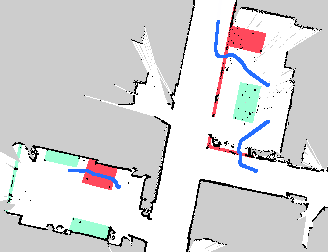
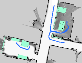
We argue that one underobserved aspect that could improve planning performance is processing the maps themself. In the previous section, we already hinted at how hypermaps could be used to generate task-specific maps to simplify planning. As an early example of that, in [21], we presented how planning on virtual layers can enable the robot to perform safer path-planning: we showed a robot avoiding obstacles—normally invisible on a 2D occupancy map—by planning with a very simple D* policy on a virtual map including deep network uncertainty over obstacle distances (Fig. 3).
Some recent work showed how the integration of traditional sampling-based path planning with a deep RL planner could effectively improve high-level task completion in different scenarios [22]. In that work, the map used was a simple metric map and the task constraints were encoded in the RL planner, but we imagine that similar approaches on task-specific maps built by combining information coming from multiple layers could enable to transfer policies between different environments and tasks more easily by changing the underlying map.
V Conclusions
In this paper we argue that in robotics there is the need to move from single-source maps to multi-layer ones—which we named hypermaps—built by combining information coming from different sensors and AI-based sources and maintaining their inter-layer relationships and correlations. Recent methods performing semantic-metric mapping are a first step in that direction, but more layers should be added, and we point out some of the recent attempts at hypermaps.
We propose that the main advantage arising from such a shift comes from the ability to use artificial intelligence to process the information in the hypermap to extract knowledge otherwise not available to the robot. This opens interesting research opportunities both when considering how to perform this knowledge extraction itself and for the benefit this formulation could bring to high-level task planning.
References
- [1] R. Siegwart, I. R. Nourbakhsh, D. Scaramuzza, and R. C. Arkin, Introduction to Autonomous Mobile Robots. USA: MIT Press, 2011.
- [2] J. Lundell, F. Verdoja, and V. Kyrki, “Hallucinating robots: Inferring Obstacle Distances from Partial Laser Measurements,” in 2018 IEEE/RSJ International Conference on Intelligent Robots and Systems (IROS). Madrid, Spain: IEEE, Oct. 2018, pp. 4781–4787.
- [3] M. Hsiao, E. Westman, G. Zhang, and M. Kaess, “Keyframe-based dense planar SLAM,” in 2017 IEEE International Conference on Robotics and Automation (ICRA), May 2017, pp. 5110–5117.
- [4] T. Krajník, T. Vintr, S. Molina, J. P. Fentanes, G. Cielniak, O. M. Mozos, G. Broughton, and T. Duckett, “Warped Hypertime Representations for Long-Term Autonomy of Mobile Robots,” IEEE Robotics and Automation Letters, vol. 4, no. 4, pp. 3310–3317, Oct. 2019.
- [5] M. Missura, D. D. Lee, and M. Bennewitz, “Minimal Construct: Efficient Shortest Path Finding for Mobile Robots in Polygonal Maps,” in 2018 IEEE/RSJ International Conference on Intelligent Robots and Systems (IROS), Madrid, Spain, Oct. 2018, pp. 7918–7923.
- [6] O. M. Mozos, H. Mizutani, R. Kurazume, and T. Hasegawa, “Categorization of Indoor Places Using the Kinect Sensor,” Sensors, vol. 12, no. 5, pp. 6695–6711, May 2012.
- [7] M. Bojarski, D. Del Testa, D. Dworakowski, B. Firner, B. Flepp, P. Goyal, L. D. Jackel, M. Monfort, U. Muller, J. Zhang, X. Zhang, J. Zhao, and K. Zieba, “End to End Learning for Self-Driving Cars,” arXiv:1604.07316 [cs], Apr. 2016.
- [8] F. Xia, A. R. Zamir, Z. He, A. Sax, J. Malik, and S. Savarese, “Gibson Env: Real-World Perception for Embodied Agents,” in 2018 IEEE/CVF Conference on Computer Vision and Pattern Recognition. Salt Lake City, UT: IEEE, Jun. 2018, pp. 9068–9079.
- [9] A. Rosinol, M. Abate, Y. Chang, and L. Carlone, “Kimera: An Open-Source Library for Real-Time Metric-Semantic Localization and Mapping,” arXiv:1910.02490 [cs], Mar. 2020.
- [10] A. Rosinol, A. Gupta, M. Abate, J. Shi, and L. Carlone, “3D Dynamic Scene Graphs: Actionable Spatial Perception with Places, Objects, and Humans,” arXiv:2002.06289 [cs], Feb. 2020.
- [11] H. Zender and G.-J. M. Kruijff, “Multi-Layered Conceptual Spatial Mapping for Autonomous Mobile Robots.” in AAAI Spring Symposium: Control Mechanisms for Spatial Knowledge Processing in Cognitive/Intelligent Systems, 2007.
- [12] H. Zender, O. Martínez Mozos, P. Jensfelt, G. J. M. Kruijff, and W. Burgard, “Conceptual spatial representations for indoor mobile robots,” Robotics and Autonomous Systems, vol. 56, no. 6, Jun. 2008.
- [13] J. Crespo, R. Barber, and O. M. Mozos, “Relational Model for Robotic Semantic Navigation in Indoor Environments,” Journal of Intelligent & Robotic Systems, vol. 86, no. 3, pp. 617–639, Jun. 2017.
- [14] T. Zaenker, F. Verdoja, and V. Kyrki, “Hypermap Mapping Framework and its Application to Autonomous Semantic Exploration,” arXiv:1909.09526 [cs], Sep. 2019.
- [15] C.-I. Chang and S.-S. Chiang, “Anomaly detection and classification for hyperspectral imagery,” IEEE Transactions on Geoscience and Remote Sensing, vol. 40, no. 6, pp. 1314–1325, Jun. 2002.
- [16] F. Verdoja and M. Grangetto, “Graph Laplacian for image anomaly detection,” Machine Vision and Applications, vol. 31, no. 1, Feb. 2020.
- [17] S. K. Narang, A. Gadde, and A. Ortega, “Signal processing techniques for interpolation in graph structured data,” in Acoustics, Speech and Signal Processing (ICASSP), 2013 IEEE International Conference On. IEEE, 2013, pp. 5445–5449.
- [18] G. Cheung, E. Magli, Y. Tanaka, and M. K. Ng, “Graph Spectral Image Processing,” Proceedings of the IEEE, vol. 106, no. 5, pp. 907–930, May 2018.
- [19] Y. Zhu, R. Mottaghi, E. Kolve, J. J. Lim, A. Gupta, L. Fei-Fei, and A. Farhadi, “Target-driven visual navigation in indoor scenes using deep reinforcement learning,” in 2017 IEEE International Conference on Robotics and Automation (ICRA), May 2017, pp. 3357–3364.
- [20] H.-T. L. Chiang, A. Faust, M. Fiser, and A. Francis, “Learning Navigation Behaviors End-to-End With AutoRL,” IEEE Robotics and Automation Letters, vol. 4, no. 2, pp. 2007–2014, Apr. 2019.
- [21] F. Verdoja, J. Lundell, and V. Kyrki, “Deep Network Uncertainty Maps for Indoor Navigation,” in 2019 IEEE-RAS International Conference on Humanoid Robots (Humanoids), Toronto, Canada, Oct. 2019.
- [22] A. Faust, K. Oslund, O. Ramirez, A. Francis, L. Tapia, M. Fiser, and J. Davidson, “PRM-RL: Long-range Robotic Navigation Tasks by Combining Reinforcement Learning and Sampling-Based Planning,” in 2018 IEEE International Conference on Robotics and Automation (ICRA), May 2018, pp. 5113–5120.