Location-Enabled IoT (LE-IoT): A Survey of Positioning Techniques, Error Sources, and Mitigation ††thanks:
Abstract
The Internet of Things (IoT) has started to empower the future of many industrial and mass-market applications. Localization techniques are becoming key to add location context to IoT data without human perception and intervention. Meanwhile, the newly-emerged Low-Power Wide-Area Network (LPWAN) technologies have advantages such as long range, low power consumption, low cost, massive connections, and the capability for communication in both indoor and outdoor areas. These features make LPWAN signals strong candidates for mass-market localization applications. However, there are various error sources that have limited the localization performance by using such IoT signals. This paper reviews the IoT localization system through the following sequence: IoT localization system review - localization data sources - localization algorithms - localization error sources and mitigation - localization performance evaluation. Compared to the related surveys, this paper has a more comprehensive and state-of-the-art review on IoT localization methods, an original review on IoT localization error sources and mitigation, an original review on IoT localization performance evaluation, and a more comprehensive review of IoT localization applications, opportunities, and challenges. Thus, this survey provides comprehensive guidance for peers who are interested in enabling localization ability in the existing IoT systems, using IoT systems for localization, or integrating IoT signals with the existing localization sensors.
Index Terms:
Low-Power Wide-Area Networks; indoor navigation; LoRa; NB-IoT; Sigfox; LTE-M; 5G; machine learning; artificial intelligence; neural networks; vehicle positioning; wireless communication; geo-spatial information; location data fusion; multi-sensor integration.I Introduction
The Internet of Things (IoT) is shaping the future of many industrial and mass-market applications [1]. As a core technology to acquire spatial IoT data, localization techniques are both an important application scenario and a distinguished feature for the next-generation IoT [2]. In particular, Location-Enabled IoT (LE-IoT) is becoming key to add location context to IoT data without human perception and intervention.
This section answers three questions: (1) why is it necessary to review localization techniques for IoT systems; (2) what are the advantages and challenges for IoT-signal-based localization; and (3) what are the differences between this survey and the previous ones. Table I illustrates the notations and symbols that will be used in this survey.
I-A Localization Technologies and Applications
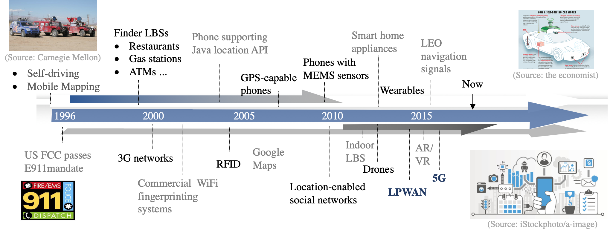
As a military-to-civilian application, localization has been intensively researched and successfully commercialized in outdoor areas. Figure 1 demonstrates the timeline of location-based services (LBS). The devices used in these applications are actually “things” in the IoT. The main technologies for these use cases are Global Navigation Satellite Systems (GNSS) and Inertial Navigation Systems (INS) [3]. In contrast, robust localization in indoor and urban areas is still an open challenge [4]. The development of indoor localization technologies has two directions: professional and mass-market applications. Professional applications (e.g., underground construction and machine industry) are commonly implemented in small areas, require high (e.g., decimeter or centimeter level) location accuracy; thus, they need specific network infrastructure, devices, and manpower. Furthermore, many professional applications also require intellisense techniques for environment sensing.
In contrast, mass-market applications commonly do not need high localization accuracy. Meter-level accuracy is already within the human sensing range. However, mass-market applications are usually implemented in wide areas with varying environments; meanwhile, these applications are not affordable for specific devices or manpower. In particular, for mass-market IoT applications, power consumption is new key factor that should be considered. In general, mass-market IoT localization is more challenging due to the following factors:
-
•
Many IoT nodes (including user end-devices) cannot afford GNSS receivers due to their high power consumption and cost.
- •
-
•
The necessity of using low-cost sensors which have significant sensor errors. The sensor errors also change over time and are susceptible to environmental factors (e.g., temperature [10]).
- •
There are various types of localization technologies. Their advantages and disadvantages are
-
•
GNSS. Because of its capability to provide global weather-independent positioning solutions, GNSS has been commercialized successfully. However, its performance can be degraded by signal outages, degradations, and multipath in indoor and urban environments [3].
-
•
Wireless localization. Localization using wireless signals can provide long-term location accuracy. However, its performance is highly dependent on signal availability and geometry [13]; meanwhile, its accuracy can be degraded by signal fluctuations and interferences due to NLoS conditions [5], reflections [14], and multipath [6], and the outage [15] and time variance [11] of radio maps.
-
•
Environmental signals (e.g., magnetic, air pressure, light, and sound intensity). Database matching (DB-M) is one main technique for localization using environmental signals. The challenges include the dependency on features in environmental signals [16], the low signal dimension [11], and the time variance and outage [17] of environmental signal feature maps.
-
•
Dead-reckoning (DR). Motion sensor (e.g., inertial sensor, magnetometer, and odometer) based DR can provide autonomous outdoor/indoor localization solutions [18]. Nevertheless, it is challenging to obtain long-term accurate DR solutions with low-cost sensors because of the existence of sensor errors [10], the misalignment angles between vehicle (e.g., human body and land vehicles) and device [20], and the requirement for position and heading initialization.
-
•
Vision localization. Vision sensors (e.g., cameras and Light Detection and Ranging (LiDAR)) can provide high location accuracy when loop closures have been correctly detected [21]. Meanwhile, some previous issues, such as a large computational load, are being eliminated by modern processors and wireless transmission technologies. However, the performance of vision localization systems is highly dependent on whether the measured features are distinct in space and stable over time. It is difficult to maintain accuracy in environments with indistinct or reduplicative features (e.g., areas with glass or solid-color walls) [22].
In general, the existing technologies have their own advantages and limitations [23]. Thus, it is difficult to generate low-cost but high-performance localization solutions through the use of a stand-alone technology. Due to the complementary characteristics of various technologies, multi-sensor integration has become a trend to achieve reliable, continuous, and accurate outdoor/indoor seamless localization.
The Low-Power Wide-Area Network (LPWAN) and 5G technologies have been used for communication in pilot sites. However, their localization capability has not been fully developed. Many of the existing IoT systems still rely on location solutions from the existing localization technologies such as GNSS [24] and Wireless Fidelity (WiFi) [25]. There are two reasons for this phenomenon. First, the deployment density (i.e., the number within a given area) of current IoT Base Stations (BS) are not high enough for accurate localization. Second, there are several error sources and challenges in IoT localization uses. For the second factor, this survey provides detailed investigation and guidance.
| Abbreviation | Definition | Abbreviation | Definition | ||
| 2D/3D | Two/Three-Dimensional | LoRaWAN | Long Range Wide-Area Network | ||
| 3GPP | 3rd Generation Partnership Project | LoS | Line-of-Sight | ||
| 5G | 5th Generation cellular network | LPWAN | Low-Power Wide-Area Network | ||
| A3C | Asynchronous Advantage Actor-Critic | LSTM | Long Short-Term Memory | ||
| AHRS | Attitude and Heading Reference System | LTE-M | Long Term Evolution for Machines | ||
| AI | Artificial Intelligence | MAC | Media Access Control | ||
| ANN | Artificial Neural Network | MIMO | Multiple-Input and Multiple-Output | ||
| AoA | Angle of Arrival | ML | Machine Learning | ||
| AR | Augmented Reality | MLP | Multi-Layer Perceptron | ||
| BLE | Bluetooth Low Energy | NB-IoT | Narrowband Internet of Things | ||
| BS | Base Station | NHC | Non-Holonomic Constraint | ||
| CNN | Convolution Neural Network | NLoS | Non-Line-of-Sight | ||
| CRLB | Cramér-Rao Lower Bound | PF | Particle Filter | ||
| CSI | Channel State Information | PHY | Physical layer | ||
| D2D | Device-to-Device | PLM | Path-Loss Model | ||
| DB-M | Database Matching | PLM-P | Path-Loss Model Parameter | ||
| DOP | Dilution of Precision | PoA | Phase-of-Arrival | ||
| DQN | Deep Q-Networks | RBF | Radial Basis Function | ||
| DR | Dead-Reckoning | RFID | Radio-Frequency IDentification | ||
| DRL | Deep Reinforcement Learning | RNN | Recurrent Neural Network | ||
| DRSS | Differential RSS | RP | Reference Points | ||
| DTM | Digital Terrain Model | RPMA | Random Phase Multiple Access | ||
| EKF | Extended Kalman Filter | RSS | Received Signal Strength | ||
| eMBB | Enhanced Mobile BroadBand | RTT | Round-Trip Time | ||
| ETSI | European Telecommunications Standards Institute | SLAM | Simultaneous Localization And Mapping | ||
| GNSS | Global Navigation Satellite Systems | SNR | Signal-to-Noise Ratio | ||
| GP | Gaussian Processes | SVM | Support Vector Machine | ||
| GSM | Global System for Mobile Communications | TDoA | Time Difference of Arrival | ||
| HMM | Hidden Markov Model | ToA | Time of Arrival | ||
| IEEE | Institute of Electrical and Electronics Engineers | UKF | Unscented Kalman Filter | ||
| IETF | Internet Engineering Task Force | UNB | Ultra NarrowBand | ||
| INS | Inertial Navigation Systems | UNREAL | UNsupervised REinforcement and Auxiliary Learning | ||
| IoT | Internet of Things | URLLC | Ultra-Reliable and Low Latency Communication | ||
| IPv6 | Internet Protocol version 6 | UWB | Ultra-Wide Band | ||
| ITU-R | International Telecommunication Union Radiocommunication Sector | VLP | Visible Light Positioning | ||
| KF | Kalman Filter | VR | Virtual Reality | ||
| LBS | Location-Based Services | Weightless-SIG | Weightless Special Interest Group | ||
| LE-IoT | Location-Enabled IoT | WiFi | Wireless Fidelity | ||
| LE-LPWAN | Location-Enabled Low-Power Wide-Area Network | ZARU | Zero Angular Rate Updates | ||
| LEO | Low Earth Orbits | ZUPT | Zero velocity UPdaTes | ||
| LF | Localization Feature | ||||
| LiDAR | Light Detection And Ranging | ||||
| LoRa | Long Range |
I-B Advantages and Challenges of IoT Signals for Localization
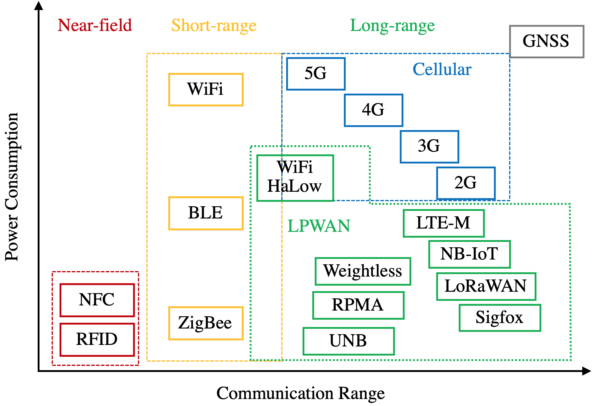
The latest communication infrastructure is beginning to support the research on IoT signal based localization because: (1) IoT signals have been supported by mainstream IoT devices and are expected to be supported by more intelligent consumer devices. (2) IoT systems can already provide various localization-signal measurements such as Received Signal Strength (RSS), Time Difference of Arrival (TDoA), and Channel State Information (CSI). (3) The popularization of IoT/5G small BSs and the possibility to enable the communication capability of smart home appliances (e.g., lamps, routers, speakers, and outlets) are increasing the density of localization BSs. This survey focuses on LPWAN signals but also covers other IoT technologies such as cellular networks (e.g., 5G) and local wireless networks (e.g., WiFi, Bluetooth Low Energy (BLE), Zigbee, and Radio-Frequency IDentification (RFID)). Figure 2 demonstrates the coverage ranges and power consumption of the main IoT signals. As a type of newly-emerged IoT signals, LPWAN has the following advantages:
-
•
Communication capability. LPWAN nodes do not require extra costly communication modules.
-
•
Long range. Theoretically, 5 to 40 kilometers in rural areas and 1 to 5 kilometers in urban areas can be achieved [26].
- •
-
•
Low cost. The cost of a LPWAN radio chipset are being reduced to within 2 dollars, while the operation cost of each node can reach 1 dollar per year [29].
-
•
Massive connections. It is expected to support millions of nodes per BS (or gateway) per square kilometers [29].
-
•
The capability to work both outdoors and indoors [30].
The research paper [29] has reviewed the physical structures, techniques, and parameters for LPWAN, as well as the specific techniques for meeting the requirements such as long range, low power consumption, and low cost.
On the other hand, the emergence of LPWAN has brought new challenges for localization techniques. Such challenges include the existence of wide-area scenarios, the high requirement for power consumption, the necessity of using low-data-rate and low-cost nodes, the high density of nodes, and the existence of complex node motions. Section IV reviews the IoT localization error sources and their mitigation in detail.
I-C Related Surveys and Tutorials
The survey paper [26] describes the development and technical differences among three main LPWAN technologies: Sigfox, NarrowBand IoT (NB-IoT), and Long-Range Wide-Area Network (LoRaWAN). Meanwhile, it describes several key IoT parameters, such as quality of service, scalability, latency, network coverage, battery life, payload length, cost, and deployment model. Also, it discusses the potential IoT applications, such as electric metering, manufacturing automation, smart building, and smart farming.
The review paper [29] investigates the LPWAN physical principles and techniques, such as band selection, modulation, narrowband, and spread spectrum techniques to meet long range requirements; topology, duty cycling, lightweight medium access control, and offloading complexity techniques to meet low-power-consumption requirements; hardware complexity reduction, minimum infrastructure, and license-free bands to meet low-cost requirements; and diversification, densification, and channel and data rate adaptive selection techniques for scalability. Moreover, the IoT standardizations from main standards organizations, such as the 3rd Generation Partnership Project (3GPP), the LoRa Alliance, the Institute of Electrical and Electronics Engineers (IEEE), the European Telecommunications Standards Institute (ETSI), the Internet Engineering Task Force (IETF), the Weightless Special Interest Group (Weightless-SIG), and the Dash7 Alliance, are described.
The paper [2] reviews the existing indoor localization technologies and methods. Specifically, localization signals, such as RSS, Time of Arrival (ToA), TDoA, Angle of Arrival (AoA), CSI, and fingerprints, are described, followed by the sensors that provide these measurements. The sensors include WiFi, BLE, ZigBee, RFID, Ultra-Wide Band (UWB), Visible Light Positioning (VLP), ultrasound, and acoustic ones. Furthermore, the paper illustrates several key indoor localization evaluation indicators, including availability, cost, accuracy, scalability, coverage range, latency, and energy efficiency. These evaluation indicators are also suitable for IoT localization. For LPWAN, the paper describes the principles, design parameters, and possibility for localization.
The review paper [32] surveys the hardware design and applications of LoRaWAN. Specifically, tools and methodologies such as system-level simulators, testbed deployments, physical layer (PHY) performance evaluation (e.g., coverage and interference impact), and Media Access Control (MAC) layer performance evaluation (e.g., network models, power usage, and security) are investigated. Meanwhile, the paper provides methods for enhancing LPWAN communication. The methods include network scalability assessment and improvement, scheduling and synchronization, new MAC design, Internet Protocol version 6 (IPv6) networks, multihop networks, and multi-modal networks. Furthermore, the strengths, weaknesses, opportunities, and threats analysis for LoRaWAN has been provided.
The paper [33] reviews the development of cellular communication technologies (i.e., 1G to 5G). It also reviews the cellular localization methods, such as proximity, scene analysis, trilateration, and hybrid localization. In particular, it predicts the impact of several 5G features on localization. These 5G features include mmWave massive Multiple-Input and Multiple-Output (MIMO), multipath-assisted localization, and Device-to-Device (D2D) communication. The localization application aspects, such as indoor positioning, heterogeneity, synchronization, interference, power consumption, device-centric and network-centric, network planning, and commercial exploitation, are covered as well.
| Features | [26] | [29] | [2] | [32] | [33] | [34] | [35] | [37] | [41] | [4] | This |
| System Principle and Architecture | S* | S | M | M | M | S | S | S | M | M | M |
| Network Structure | M | S | M | S | S | S | S | S | M | W | W |
| Hardware Technique | M | S | W | S | S | M | M | M | S | W | W |
| MAC Layer | S | S | W | S | S | S | S | S | M | W | W |
| PHY | S | S | W | S | S | S | S | S | M | W | W |
| Standardization | S | S | W | M | M | S | S | S | M | W | W |
| Existing System | M | S | S | W | M | M | S | S | W | W | S |
| Localization Signal Source | W | W | S | W | M | M | W | M | M | M | S |
| Localization Algorithm | W | W | M | W | M | M | W | W | M | S | S |
| Localization Error Source and Mitigation | W | W | W | W | W | M | W | W | W | W | S |
| Localization Performance Evaluation | W | W | W | W | M | M | W | W | W | W | S |
| Localization Application | W | W | S | M | M | S | W | M | M | S | S |
| New Localization Opportunity | W | W | M | M | M | S | W | M | S | M | S |
-
*
* S-Strong; M-Medium; W-Weak
The whitepaper [34] has systematically introduced the 5G and IoT standards, new features, applications, and limitations. Meanwhile, it points out several localization challenges, such as heterogeneity, multipath propagation, Line-of-Sight (LoS) availability, time synchronization, hardware complexity in large antenna array systems, power consumption and computational burden, and MAC latency and bandwidth usage. Also, the theoretical accuracy limitation for 5G ToA and AoA localization methods are derived.
The review paper [35] surveys the characteristics of various LPWAN technologies, including Sigfox, LoRaWAN, NB-IoT, Long Term Evolution for Machines (LTE-M), Random Phase Multiple Access (RPMA), and WavIoT. The investigated characteristics include network model and methodology, link budget and its impact on the implication, signal propagation, and network performance analysis (e.g., coverage, sensitivity analysis and network optimization, transmission delay, and energy consumption).
The paper [37] focuses on LPWAN PHY features (e.g., link layer and network architecture) and the analysis of LoRaWAN performance, such as the Doppler effect, node data rate, scalability, and network capacity. Localization scenario factors such as angular/linear velocity and outdoor coverage are considered in experiments.
The survey paper [41] reviews the 5G system principles, channel models and improvements, channel-parameter estimation, and localization. The channel-parameter estimation approaches involve subspace methods, compressed sensing, and distributed sources. The localization methods include LoS/NLoS localization, non-cooperative/cooperative localization, and indirect/direct localization. Furthermore, the paper analyzes 5G-localization opportunities and challenges, including efficient channel parameter estimation, accurate mmWave propagation modeling, cooperative localization, and the use of Artificial Intelligence (AI) techniques.
The survey paper [4] reviews the IoT localization and path-planning approaches. The localization techniques include multilateration, multiangulation, centroid, energy attenuation, region overlapping, bionics, verification, landmark design, clustering, and historical-information based methods. Furthermore, it summarizes the motion models, such as those for random walk, random waypoint, group mobility, self-organizing, and probability distribution. Meanwhile, it introduces the estimation approaches, such as multidimensional scaling, least squares, semi-definite programming, maximum likelihood estimation, Bayesian estimation, and Monte Carlo estimation. This paper provides the most systematical survey on IoT localization and estimation approaches.
In general, the existing surveys (e.g., [26][29][34]) and numerous on-line resources have introduced the LPWAN and 5G principles, developments, technologies, and applications. Most of these resources focus on their communication capability. For localization purposes, the papers [2][4][34][41] already have a systematical review on localization sensors and approaches. However, none of these papers has reviewed localization error sources and mitigation, which are key to design, use, and improve an LE-IoT system. This survey fills this gap. Table II compares this paper with the related surveys.
I-D Main Contributions and Structure
This paper reviews the IoT localization system in the following order: IoT localization system review - localization data sources - localization algorithms - localization error sources and mitigation - localization performance evaluation. Thus, it provides a comprehensive guidance for peers who are interested in enabling localization ability in the existing IoT systems, using IoT systems for localization, or integrating IoT signals with the existing localization sensors. In particular, this paper is the first survey on IoT localization error-source analysis, error mitigation, and performance evaluation. Compared to the related surveys, this paper has
-
•
A more comprehensive and state-of-the-art review on IoT localization methods.
-
•
The first review on IoT localization error sources.
-
•
The first review on IoT localization error mitigation.
-
•
The first review on IoT localization performance analysis and evaluation.
-
•
A more comprehensive review of IoT localization applications, opportunities, and challenges.
Table III illustrates the paper structure and the questions that are answered in each section. This survey is organized as follows
| Section | Subsection | Questions Answered |
| I. Introduction | • I-A. Localization Technologies and Applications • I-B. Advantages and Challenges of IoT Signals for Localization • I-C. Related Surveys and Tutorials • I-D. Main Contributions and Structure | • Why is it necessary to review localization techniques for IoT systems • What are the advantages and challenges for IoT-signal-based localization • What are the differences between this survey and the previous ones |
| II. Overview | • II-A. LPWAN Technologies • II-B. IoT Localization Applications • II-C. IoT Localization System Architecture • II-D. IoT Localization Signal Measurements | • How to select a LPWAN technology from the perspective of localization system designers • What can a LE-IoT system be used for • Which types of localization signals can be used |
| III. IoT Localization Methods | • III-A. DB-M Localization Methods • III-B. Geometrical Localization Methods | • What are the state-of-the-art localization approaches • What are the advantages and challenges for each type of localization method |
| IV. IoT Localization Error Sources and Mitigation | • IV-A. End-Device-Related Errors • IV-B. Environment-Related Errors • IV-C. Base-Station-Related Errors • IV-D. Data-Related Errors | • Which types of localization error sources should be considered when designing a LE-IoT system • How to mitigate the effect of each type of localization error source |
| V. IoT Localization-Performance Evaluation Methods | • V-A. Theoretical Analysis • V-B. Simulation Analysis • V-C. In-the-lab Testing • V-E. Field Testing • V-D. Signal Grafting | • What are the existing localization-performance evaluation methods • What are the advantages and limitations of these localization-performance evaluation methods |
| VI. Localization Opportunities From LPWAN and 5G | • VI-A. Cooperative Localization • VI-B. Machine Learning / Artificial Intelligence • VI-C. Multi-Sensor Integration • VI-G. Fog/Edge Computing • VI-H. Blockchain • VI-E. Airborne-Land Integrated Localization • VI-F. Multipath-Assisted Localization | • What are the new opportunities for localization due to the emergence of LPWAN and 5G signals |
Section II overviews the existing IoT technologies, followed by IoT localization applications, system architecture, and signal measurements.
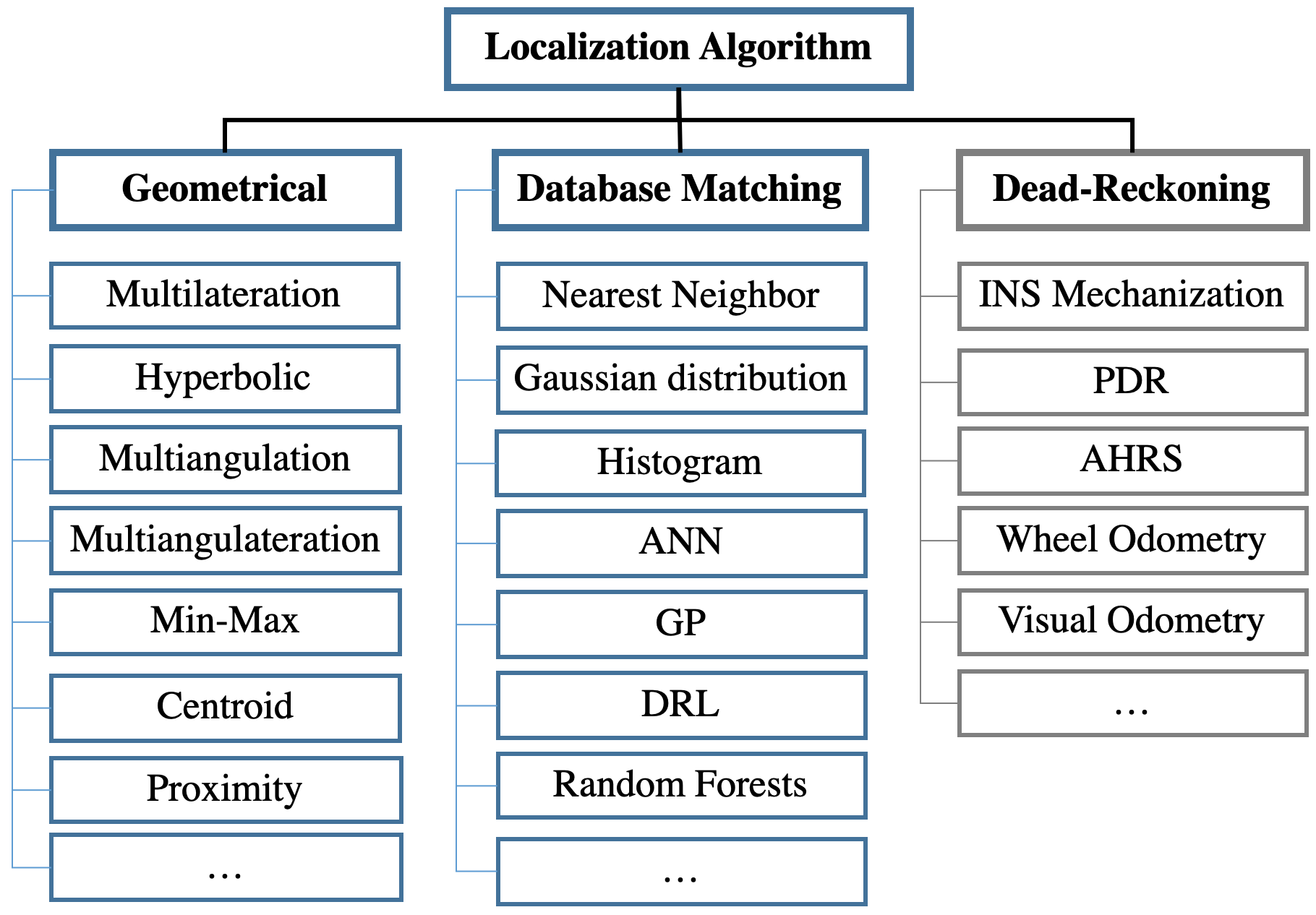
Section III demonstrates the state-of-the-art IoT localization methods, including DB-M and geometrical localization. Specifically, DB-M approaches include deterministic DB-M methods such as nearest neighbors, stochastic DB-M methods such as Gaussian-distribution and histogram-based ones, and Machine-Learning (ML)-based DB-M methods such as Artificial Neural Network (ANN), random forests, Gaussian Processes (GP), and Deep Reinforcement Learning (DRL). Meanwhile, geometrical methods involve multilateration, hyperbolic positioning, multiangulation, multiangulateration, min-max, centroid, and proximity.
Afterwards, Section IV systematically reviews IoT localization error sources and mitigation. The location errors are divided into four parts: (1) end-device-related errors (e.g., device diversity, motion/attitude diversity, low response rate/low sampling rate/data loss/data latency, and channel diversity), (2) environment-related errors (e.g., multipath, NLoS, wide-area effects, multi-floor effects, human-body effects, weather effects, and signal variations), (3) BS-related errors (e.g., number of BSs, BS geometry, BS location uncertainty, BS Path-Loss Model Parameter (PLM-P) uncertainty, and BS time synchronization errors), and (4) data-related errors (e.g., database timeliness/training cost, Reference Point (RP) location uncertainty, database outage, data and computational loads, and localization integrity).
Then, Section V illustrates the localization performance evaluation methods, including theoretical analysis, simulation analysis, in-the-lab testing, field testing, and signal grafting.
Finally, Section VI shows the new localization opportunities, such as cooperative localization, AI, multi-sensor integration, motion constraints, fog/edge computing, blockchain, airborne-land integration, and multipath-assisted localization.
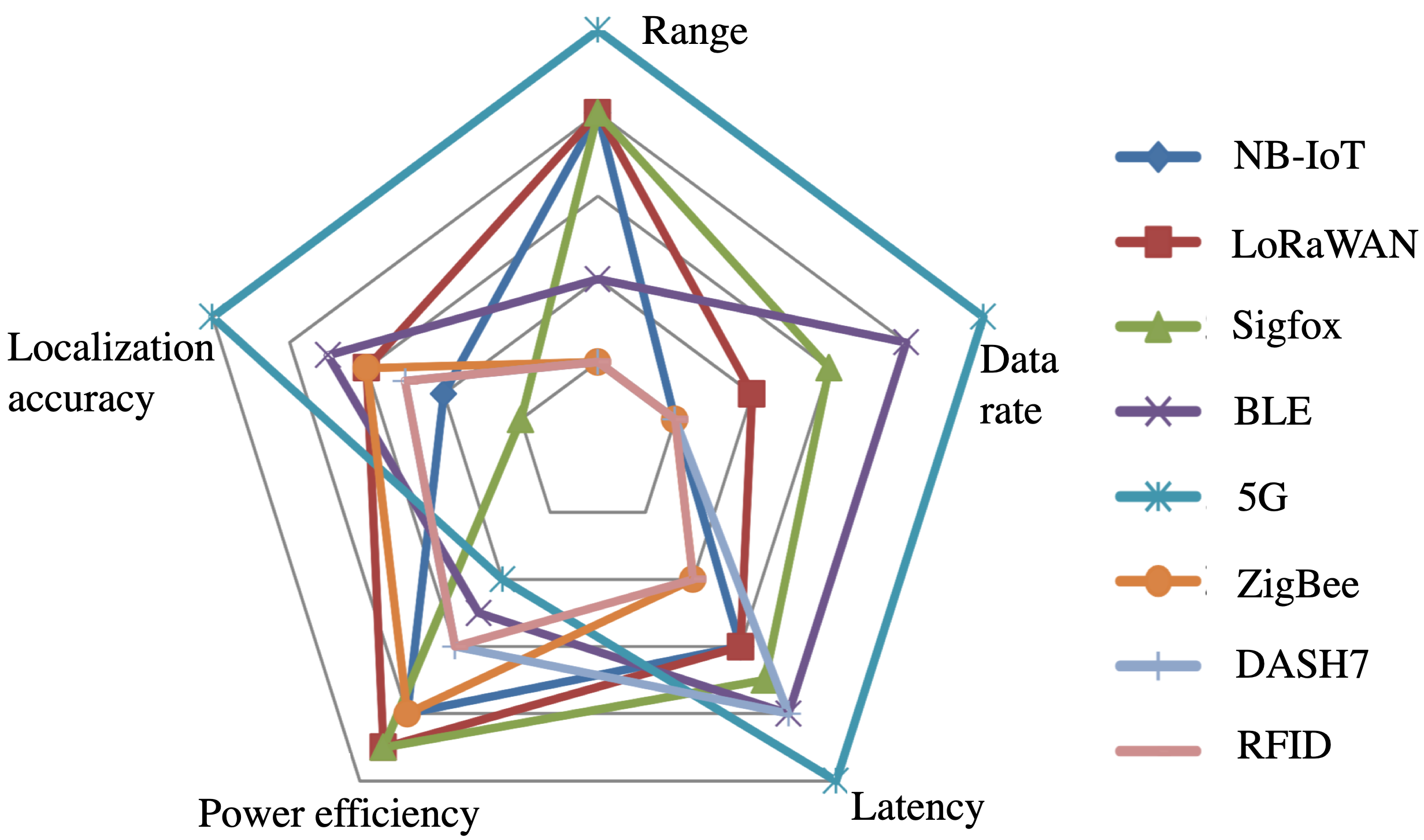
| Features | NB-IoT | LoRa | Sigfox | LTE-M | Weightless-N | RPMA | HaLow | 5G |
| Standardization | 3GPP | LoRa-Alliance | Sigfox and ETSI | 3GPP | Weightless SIG | Ingenu | IEEE | 3GPP |
| Licensed | Yes | No | No | Yes | No | No | No | Yes |
| Frequency | In band LTE | 868/915/433 MHz ISM | 862-928 MHz ISM | In band LTE | Sub-1Ghz ISM | 2.4 GHz ISM | 900 MHz | Low/Mid/ mmWave bands |
| Bandwidth | 200 kHz | 250/125 kHz | 100 Hz | 1.4 MHz | 12.5 kHz | 80 MHz | 1/2/4/8/16MHz | 100/400 MHz |
| Range | 1/10 km in urban/rural | 5/20 km in urban/rural | 10/40 km in urban/rural | 0.7/7 km in urban/rural | 3 km in rural | 5 km in rural | 1 km | Few hundreds of meters |
| Peak data rate | 250 kbps | 3-50 kbps | 600 bps | 1 mbps | 30-100kbps | 8bps-8 kbps | 347 mbps | Gbps level |
| Messages per day | Limited | Unlimited | 140/4 | Unlimited | Unlimited | Undisclosed | Unlimited | Unlimited |
| Peak payload length | 1600 bytes | 243 bytes | 12/8 bytes | 100 byte level | 20 bytes | 10 kb | Very large | Very large |
| Cellular network | Yes | No | No | Yes | No | No | No | Yes |
| Network type | Nationwide | Nationwide/ Private | Nationwide | Nationwide | Nationwide/ Private | Nationwide/ Private | Private | Nationwide |
| Authentication & Encryption | LTE encryption | AES 128b | Not supported | LTE encryption | AES 128b | AES 256b | IEEE 802.11 high-level | LTE encryption |
| Capacity of Nodes | 50 k/BS | 200 k/ gateway | 1 m/gateway | 50 k/BS | Undisclosed | 100 k/BS level | 8 k/BS | 1m/km2 |
| Power Consumption | Low | Low | Low | Medium, band dependent | Low | Low | Medium | Medium |
| Time latency | 5 sec | 1-10 sec | 1-30 sec | 100 ms | 5-10 s | over 25 sec | ms level | ms level |
| BS Cost | $15k/BS | $100/gateway, $3k/BS | $4k/BS | $15k/BS | $3k/BS | Undisclosed | $100 level/gateway | $10k/BS |
| Node Cost | $5-15 | $3-10 | $3-10 | $10-20 | $3-10 | $5-10 | $10-15 | Higher |
| Topology | Star | Star of stars | Star | Star, mesh | Star of stars | Star | Star | Star, mesh |
II Overview
This section first compares the existing LPWAN systems from the perspective of localization-system users, followed by the application scenarios of IoT localization. Afterwards, the IoT localization system architecture and the types of localization signal measurements are described. This section answers the following questions: (1) how to choose a LPWAN system for localization purposes; (2) what are the potential application scenarios for LE-IoT systems; and (3) what are the possible measurements that can be used for localization. Table IV compares the features of the main LPWAN techniques.
II-A LPWAN Technologies
IoT, which was started as embedded internet or pervasive computing in 1970s and was termed in 1999, has a history of decades. The early-state IoT systems mainly used local communication technologies (e.g., RFID, WiFi, BLE, and Zigbee) and GNSS localization until LPWAN systems became available in around 2013 [26]. Afterwards, over ten LPWAN technologies, licensed or license-free, were presented. Among them, LoRaWAN [42] and Sigfox [43], which use license-free bands, and NB-IoT [44] and LTE-M [44], which use licensed bands, are most widely used. Meanwhile, there are other LPWAN technologies, such as WiFi HaLow [45], Weightless [46], Ingenu RPMA [47], Telensa [48], and Qowisio [49]. The papers [26][29][32][35] have detailed descriptions on these LPWAN technologies. Figure 3 illustrates the comparative aspects of several IoT technologies. The following subsections describe the characteristics and applications of the main LPWAN systems.
II-A1 LoRaWAN
LoRa was developed by the startup company Cycleo and was acquired by Semtech in 2012. Afterwards, the LoRa Alliance was founded in 2015. Until July 2019, the LoRa Alliance already has over 500 members and has deployed 76 LoRa public networks in 142 countries [42]. Thus, LoRa is one of the LPWAN technologies that have attracted extensive attention.
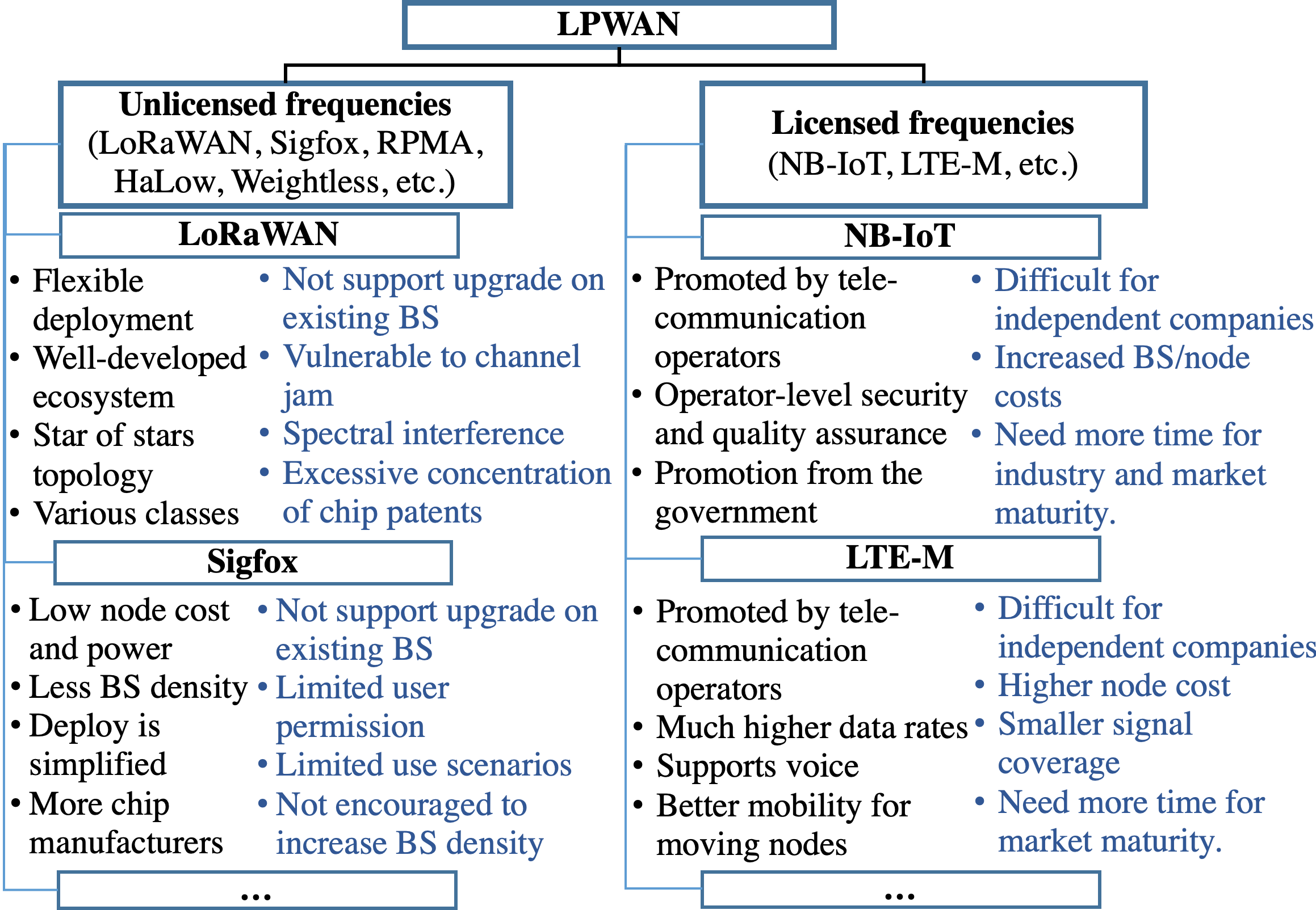
LoRaWAN has the following advantages: (1) its deployment is flexible. The user can deploy either a public or private network without the license from telecommunication operators. Thus, it is suitable for independent areas, such as communities, campuses, farms, and industrial parks, especially those in indoor or underground areas where the telecommunication signals are degraded. In these areas, localization is usually needed. (2) LoRaWAN has a well-developed ecosystem. A complete chain of LoRa chipsets - sensors and modules - BSs and gateways - network services - application services has already been set up. The standardization from the LoRa Alliance assures the interoperability among LoRaWAN in different countries. (3) In contrast to most of LPWAN systems which use a star topology, LoRaWAN uses a star of stars topology. That is, gateways are introduced to bridge nodes and BSs. The use of gateways, which have a lower cost and are more flexible to deploy, may enhance network coverage and localization performance in urban and indoor areas. (4) LoRaWAN support various classes (i.e., A, B, and C) for applications with various power and latency requirements.
There are two types of challenges for LoRaWAN. The first type is the challenges for all LPWAN systems that use license-free bands: (1) it does not support upgrade using existing telecommunication BSs. That is, it always needs specific network deployment. (2) it is vulnerable to attacks due to its license-free bands and open standards. Although LoRaWAN has a relatively strong security standard, attackers may use LoRa nodes to jam the signal channel. (3) Spectral interference may occur with the increase of LoRaWAN operators. The second type of challenges only exists in LoRaWAN: (4) LoRa chipsets have been patented by Semtech. The excessive concentration of chip patents is not conducive to industrial growth.
II-A2 Sigfox
Sigfox was developed by the startup Sigfox and then has experienced rapid development in the recent years. Until July 2019, Sigfox has already deployed networks in over 60 countries and regions [43]. It has generally completed the coverage of western Europe and is promoting to Asia and America. Although Sigfox and LoRaWAN use license-free bands, they have different operation modes. A main difference is that the Sigfox company itself acts as the global network operator.
The main advantages of Sigfox include: (1) it has a low node hardware cost and power consumption. To reduce cost, Sigfox uses the Ultra NarrowBand (UNB) technology and limits the data rate (100 bit/s/node level), message length (12 bytes) and the number of messages (140 message/day/node). Such a low data rate can reduce the node cost because even low-cost Binary Phase Shift Keying (BPSK) modules can meet the requirement [26]. (2) Due to the use of UNB and short messages, a Sigfox network can be deployed by using a smaller number of long-range BSs. (3) It is straightforward to deploy a Sigfox network. The Sigfox company, which acts as the global operator, helps the users to deploy networks. Meanwhile, Sigfox is a global network, which does not need roaming between countries. (4) In contrast to LoRaWAN, Sigfox allows users to select chipsets from various chip manufacturers.
The challenges for Sigfox include: (1) having the Sigfox company as a global operator has limited user permission and application flexibility. The users need to register and pay to the Sigfox company for services. Furthermore, the data has to be stored on the Sigfox server. (2) Both the UNB technology and the narrow downlink (i.e., the link from BS to node) have strongly limited the application scenarios. It is not cost-effective to use a Sigfox network for low-data-rate applications and use another LPWAN network for other applications. (3) From the localization perspective, having high-density BSs is generally beneficial. However, increasing the density of BSs contradict Sigfox’s advantage of a lower BS density.
II-A3 NB-IoT
Both NB-IoT and LTE-M started later than LoRaWAN and Sigfox. The 3GPP released the R13 NB-IoT standardization in 2016. However, the NB-IoT community is growing quickly. Until March 2019, it already has 140 operators in 69 countries [50].
NB-IoT is mainly promoted by telecommunication operators. The main advantages of NB-IoT include: (1) it is highly valued by telecommunication operators. First, it supports upgrade on existing telecommunication BSs. Second, it can increase the number of users and bring extra service fees to the operators. (2) NB-IoT is based on licensed bands, which has an operator-level security and quality assurance. (3) The promotion from the government. For example, the China Ministry of Industry and Information Technology has released a policy to promote the development of NB-IoT in June 2017. On the other hand, NB-IoT has met the following challenges: (1) it is difficult for independent companies, which are not cooperating with telecommunication operators, to participate. (2) The use of licensed bands increases the costs of both BSs and nodes. (3) NB-IoT started later than LoRa and Sigfox and thus may need time to achieve the same industry and market maturity.
II-A4 LTE-M
LTE-M, which includes enhanced Machine Type Communication (eMTC), was released in the 3GPP R13 standardization. This is similar to NB-IoT. Meanwhile, LTE-M is also designed for low-bandwidth cellular communications for the internet devices that transmit small amounts of data and have lower costs but higher battery life. Until March 2019, it has 60 operators in 35 countries [50]. Generally, LTE-M is relatively more supported by telecommunication operators in North America, while NB-IoT is more popular in China and Europe.
Compared to NB-IoT, LoRa, and Sigfox, LTE-M has its own advantages: (1) LTE-M has much higher (i.e., up to 1 Mbps) data speeds. (2) It supports voice communication. (3) It has better mobility for devices in movement. Thus, LTE-M is suitable for applications such as vehicle networks, transportation, and security cameras.
The challenges for LTE-M include: (1) its nodes have a higher complexity and cost. LTE-M has a higher bandwidth (1.4 MHz) than NB-IoT (200 KHz); thus, both front end and digital processing are more complex for LTE-M. (2) LTE-M has a smaller signal coverage compared to other LPWAN technologies.
II-A5 Summary and Insight on LPWAN Technologies
Figure 4 illustrates the advantages and challenges of NB-IoT, LTE-M, LoRaWAN, and Sigfox. Although they have attracted most interests, there are various other LPWAN systems that have their own advantages. Therefore, it is expected that the users can select LPWAN technologies according to their requirements and integrate multiple LPWAN signals for better communication and localization performances.
II-A6 Relation Between LPWAN and 5G
In addition to LPWAN, the development of 5G (i.e., the fifth-generation cellular network) technology has brought opportunities for both communication and localization. Thus, it is worthwhile to introduce the relation between LPWAN and 5G.
5G has been well-known for its high speed, massive connection, high reliability, and low latency in communication. Compared to 4G, 5G has innovatively designed various standards and solutions for different application scenarios. The International Telecommunication Union Radiocommunication Sector (ITU-R) has defined three 5G application categories: Ultra-Reliable and Low Latency Communication (URLLC), Enhanced Mobile BroadBand (eMBB), and massive Machine-Type Communication (mMTC) [51]. Specifically, URLLC has the advantages of high reliability (e.g., 99.999 % reliable under 500 km/h high-speed motion) and low-latency (e.g., millisecond level); thus, it is suitable for applications such as vehicle networks, industrial control, and telemedicine. By contrast, eMBB has an extremely high data rate (e.g., Gbps level, with a peak of 10 Gbps) and strong mobility; thus, it is suitable for video, Augmented Reality (AR), Virtual Reality (VR), and remote officing applications. In contrast, mMTC is designed for application scenarios that have massive nodes which have a low cost, low power consumption, and low data rate, and are not sensitive to latency. Examples of these applications include Intelligent agriculture, logistics, home, city, and environment monitoring.
Therefore, LPWAN can aid 5G as follows: (1) LPWAN provides an important application direction for 5G, especially mMTC, applications. (2) Besides NB-IoT and LTE-M, which are within the 5G standardization group, there are various LPWAN networks and systems. They can provide complementary supports to 5G techniques and applications.
On the other hand, 5G can help the development of LPWAN: (1) 5G is expected to build the fundamental infrastructure for communication services. In particular, the coverage range for 5G BSs may shrunk from kilometers to hundreds of meters or even under 100 m [52]. The existence of such small BSs can help LPWAN communication and localization. (2) 5G features (e.g., mmWave MIMO, large-scale antenna, beamforming, and D2D communication) may enhance the LPWAN performance and experience. (3) 5G has a stronger connection with the new-generation information technologies (e.g., big data, cloud/edge computing, and AI) and thus can extend the application space of LPWAN.
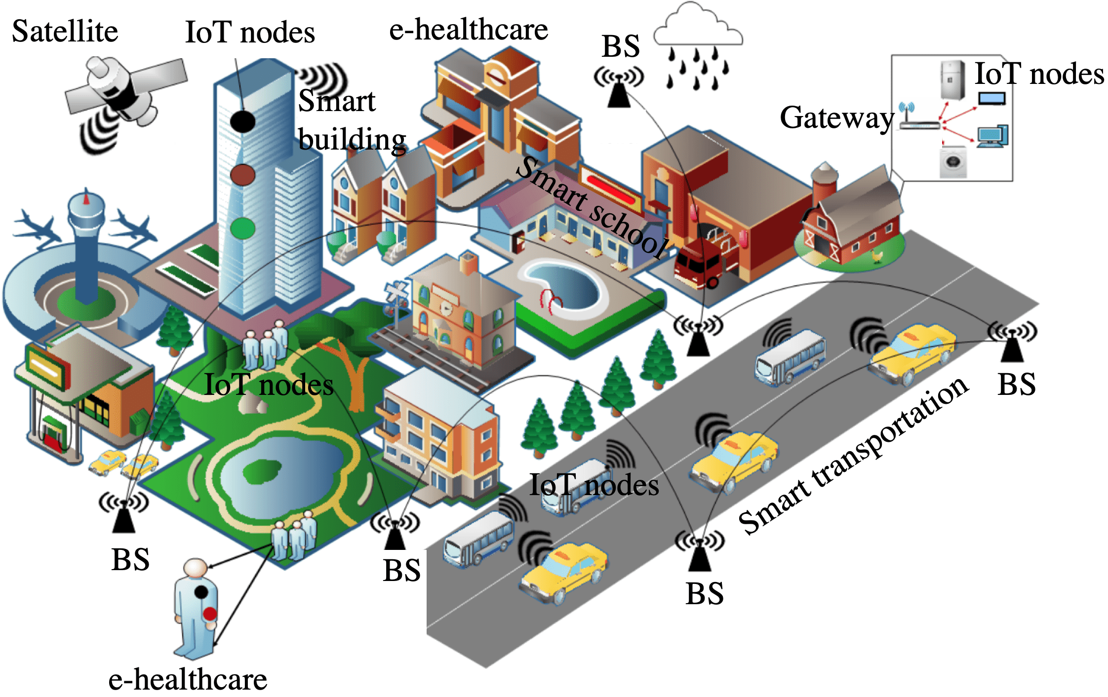
II-B IoT Localization Applications
According the above analysis, IoT systems are especially suitable for applications that have massive connection, low data rate, low power consumption, and are not sensitive to latency. Many of such applications have a strong requirement for localization. Examples of these applications include
-
•
Emergency service: determining people location is a feature of increasing importance for emergency systems such as the Enhanced 911 (E-911) in North America [53] and the E-112 in Europe [54]. The current E-911 system uses cellular signals and has a typical localization accuracy of 80 % for an error of 50 m. To enhance location accuracy in urban and indoor areas, other localization signals, including IoT signals, are needed.
-
•
Smart community: through the deployed IoT BSs and nodes around a community, it is possible to localize and track the residents as well as obtain their surrounding facilities (e.g., security alarms, fire alarms, lamps, air conditioners, and surveillance cameras).
-
•
Shopping mall: LE-IoT can be used for wide-area product positioning and management. Meanwhile, the data pertinent to people and products can be used for big-data analysis and service optimization. LE-IoT can provide the localization and management of public infrastructure such as vending machines, point-of-sale terminals, and advertising light boxes.
-
•
Intelligent transportation: LE-IoT nodes or chips in vehicles (e.g., cars or bikes) can be used for positioning and information tracking. The vehicle and related infrastructure (e.g., charging piles and parking spaces) locations can be used for traffic monitoring and parking guidance.
-
•
Smart logistics: LE-IoT can provide city-level wide-area product tracking and management.
-
•
Environmental monitoring: LE-IoT can be used for localizing environmental hazards such as debris flows, sewer abnormities, and hazardous wastes.
-
•
Smart animal husbandry: LE-IoT can be used to track livestock locations and motions and thus provide services such as diet monitoring and meat traceability.
-
•
Animal tracking: LE-IoT can be used for wildlife tracking, pet monitoring, and animal movement data analysis.
-
•
Smart agriculture: LE-IoT nodes around farms can be used to localize fertilization devices and monitoring environmental factors (e.g., temperature and humidity).
-
•
Smart home: LE-IoT nodes in smart home appliances (e.g., smart speakers, lamps, and outlets) and those on the human body can provide personalized services such as automatic temperature adjustment and light control.
-
•
Health care: LE-IoT can localize patients and medical devices and then provide services such as remote monitoring, fall detection, and motion analysis.
Figure 5 demonstrates some of the LE-IoT applications. Many of the current LE-IoT nodes use existing localization sensors (e.g., GNSS, inertial sensors, WiFi, and RFID) and an extra communication module (e.g., LTE). Thus, these nodes have relatively high cost and high power consumption, which have limited their applications. With the advent of LPWAN, some costly communication modules can be replaced by LPWAN based modules. For example, the configuration of LPWAN plus GNSS have been used for applications such as bus tracking [56], highway tracking [57], and patient-motion monitoring [58]. Also, it is feasible to use LPWAN to send GNSS raw measurements to a server for processing [24], or using WiFi instead of GNSS for localization [25]. In these applications, the node hardware cost has been significantly reduced. Furthermore, if the LPWAN localization capability can be explored, it will be possible to remove all or parts of other localization sensors and thus further reduce node cost and power consumption.
II-C IoT Localization System Architecture
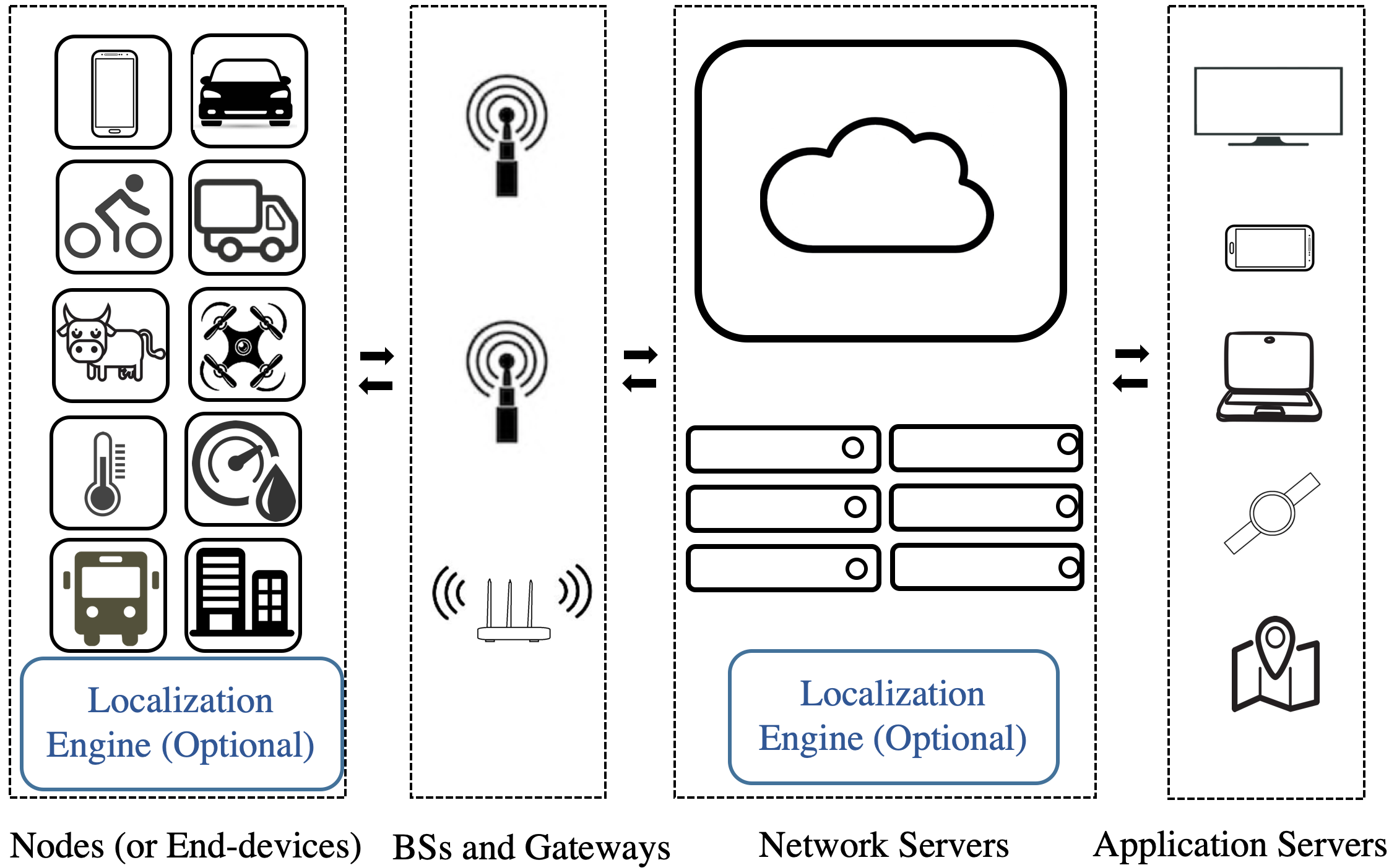
A LE-IoT system is comprised of four components: nodes (including end-devices), BSs (including gateways or anchors), network servers, and application servers [29]. Figure 6 shows an LE-IoT system architecture. The LE-IoT system has an extra localization engine compared to an ordinary IoT system. The localization module may be located at either nodes or network servers, depending on user requirements on factors such as node computational load, communication load, and data security. The main functionalities of its components are as follows.
II-C1 Nodes
A node contains a transponder, which transmits signals, and optionally a micro-controller with on-board memory. Meanwhile, the node optionally has application sensors such as a GNSS receiver for precise positioning, inertial sensors for motion tracking, and environmental sensors for monitoring temperature, humidity, smoke, gas, light, magnetic, and sound. The sensors may be connected to or integrated within the transponder chip. Also, the nodes may be fixed for static monitoring, mounted on dynamic objects (e.g., products, vehicles, and animals) as tags, or put on human body as user devices. In some IoT applications, the nodes only broadcast signals frequently, instead of processing data, to save energy. There are also applications in which motion-tracking or localization data processing is implemented on nodes to reduce communication load. Meanwhile, some applications may use ToA localization, which requires precise timing on nodes. This requirement can only be met in relatively high-end IoT applications.
II-C2 BSs
The main communication function of BSs is to route the data between nodes and network servers. The BSs may connect to network servers via the standard user datagram protocol / internet protocol and transmit the data from node sensors to network servers and vice versa. BSs usually have fixed and known locations as well as globally unique IDentities (IDs, e.g., MAC addresses). For LE-IoT, BSs also need to measure localization signals, such as node ID, BS ID, the data reception time, channel, RSS, payload, and Signal-to-Noise Ratio (SNR). Furthermore, BS time synchronization may be required for TDoA or ToA based localization [59]. Meanwhile, multi-array antennae and phase detection may be needed for AoA localization [60].
II-C3 Network servers
A network server is responsible for decoding data from BSs, recording data into databases, optionally implementing localization computation, and transmitting processed data to application servers. Network servers can be used for both sensor-to-application and application-to-sensor communication. For TDoA based localization, it is important that the packets from different BSs arrive at a network server. Furthermore, for localization applications, there are extra localization-signal databases on network servers. Meanwhile, motion-tracking and localization data-processing engines are located at network servers for many LPWAN applications. Network servers may be either cloud or edge servers.
II-C4 Application servers
Their main functions are to obtain data from network servers, parse it, and process it for further applications.
II-D IoT Localization Signal Measurements
Compared to IoT, LE-IoT systems measure localization signals and process them to estimate motion states such as location, velocity, attitude, and motion modes. This subsection illustrates the commonly used localization signals.
II-D1 RSS
RSS is measured when a BS or node receives the data packet from the other side. The advantages of using RSS include: (1) RSS can be straightforwardly collected without extra hardware on either nodes or BSs. (2) RSS can be flexibly used for various localization algorithms, such as proximity, region-determination, multilateration, and DB-M. On the other hand, the challenges for using RSS include: (1) it is difficult to determine the PLM-P accurately in wide-area [61], urban [62], and indoor [63] scenarios, where many IoT applications take place. (3) The RSS-ranging resolution degrades over node-BS distance. Specifically, an RSS change of one dBm may lead to distance differences of meters in small areas but hundreds of meters in wide areas. Meanwhile, RSS measurements vary significantly when the node-BS distance changes within a certain range but less significantly when the node-BS distance becomes far [30]. (4) RSS variations and interference due to environmental factors are issues inherent to wireless signals.
II-D2 ToA
ToA is obtained by measuring the time interval between signal transmission and reception. The advantages of using ToA include: (1) theoretically, ToA measurements can be linearly converted to node-BS distances without any known PLM-P. (2) Take UWB [64] and ultrasonic [65] as examples, ToA ranging can achieve high accuracy (e.g., decimeter or even centimeter level) in light-of-sight (LoS) environments. (3) ToA localization has a well-researched theoretical-derivation and accuracy-assessment mechanism [66]. The challenges for ToA localization include: (1) ToA measurements require precise timing on both nodes and BSs, or precise time synchronization between them. A ten-nanosecond-level timing accuracy is required to achieve meter-level ranging. Such timing accuracy is not affordable for many IoT nodes. Thus, TDoA operating across multiple BSs is commonly used in IoT localization to eliminate the requirement for precise timing on nodes. (2) A high accuracy is commonly expected when ToA is used. In this case, the degradations from environmental factors (e.g., NLoS and multipath) are relatively more significant.
II-D3 TDoA
TDoA is measured by computing the signal arrival time differences among multiple BSs. TDoA localization has the following advantages: (1) it does not need precise timing on nodes or precise time synchronization between nodes and BSs. Instead, it only requires precise BS time synchronization, which is affordable for many IoT systems such as LoRa, Sigfox, and NB-IoT [59]. (2) The impact of node diversity can be mitigated through the use of differential measurements between BSs. (3) TDoA localization methods, such as hyperbolic localization, have a well-researched theoretical-derivation and accuracy-assessment mechanism [67]. On the other hand, the challenges for TDoA localization include: (1) the requirement of precise time synchronization increases the BS cost. (2) The use of differential measurements enhances the impact of noise in localization signals.
II-D4 AoA
AoA systems provide the node position by measuring BS-node angles [68]. The advantages of AoA positioning include: (1) typical AoA localization systems (e.g., the HAIP system [69]) can provide high-accuracy (e.g., decimeter or centimeter level) locations. (2) AoA requires less BSs than ToA and TDoA. It is feasible to use two BS-node angle measurements, or one BS-node angle and one BS-node distance, for two-dimensional (2D) localization. By fixing the AoA BS on the ceiling with known height, it is even possible to provide accurate localization with one BS [69]. (3) AoA localization approaches, such as multiangulation, have a well-researched theoretical-derivation and accuracy-assessment mechanism [70]. The challenges for AoA localization include: (1) AoA systems need specific hardware such as multi-array antennae and phase detection [60]. The high node cost has limited the use of AoA in low-cost IoT applications. (2) Although there are low-cost RSS-based AoA systems [71], the accuracy of both angular-measuring and positioning degrade significantly when the BS-node distance increases. Thus, a high-density BS network is still needed for wide-area applications.
II-D5 Round-Trip Time (RTT)
RTT can be collected by measuring the round-trip signal propagation time to estimate the distance between nodes and BSs [72]. The use of RTT has advantages such as: (1) compared to ToA, RTT needs less accurate clock synchronization between BSs and nodes [2]. (2) RTT can be collected from the MAC layer, instead of the PHY [73]. (3) It is straightforward to use ToA-localization methods for RTT localization. The challenges for RTT localization include: (1) Modification on nodes is not affordable for many low-cost IoT applications. (2) The response delay between signal reception and transmission, which is difficult to eliminate, directly leads to ranging errors [2]. (3) RTT-estimation accuracy is degraded by the same error sources as ToA.
II-D6 CSI
It is becoming possible to collect CSI between IoT nodes and BSs [74]. The advantages of using CSI include (1) CSI localization can achieve a high accuracy (e.g., decimeter level or higher) [75]. (2) CSI measurements have more features than RSS [76]. (3) CSI is more robust to multipath and indoor noise [2]. (4) Many existing localization approaches, such as DB-M and multilateration, can be used for CSI localization. The challenges for CSI localization include: (1) CSI may not be available on off-the-shelf Network Interface Controllers (NICs). (2) The CSI measurements may suffer from deviations because of factors such as limitations in channel parameter estimation [76]. (3) It is challenging to assure the CSI-based ToA measurement accuracy due to the limited IoT signal bandwidth [76]. To mitigate this issue, techniques such as frequency hopping may be needed [77].
II-D7 Phase-of-Arrival (PoA)
PoA is obtained by measuring the phase or phase difference of carrier signals between nodes and BSs. PoA measurements can be converted to BS-node distances [78]. The advantages for PoA localization include: (1) PoA measurements can achieve high (e.g., centimeter-level or higher) ranging accuracy [79]. (2) The existing ToA and TDoA algorithms can be directly used for PoA localization. The challenges for PoA localization include: (1) Extra node and BS hardware are needed to measure PoA [78]. Meanwhile, accurate PoA-ranging requires a relative high data rate, which is not suitable for many IoT applications. (2) A high accuracy is commonly expected when PoA is used. In this case, the degradations from environmental factors (e.g., NLoS and multipath) are relatively more significant [78]. (3) PoA measurements may suffer from the integer-ambiguity issue [80] and cycle slips [81].
II-D8 Summary and Insight on IoT Localization-Signal Measurements
-
•
Similar to other engineering problems, the selection of IoT localization signals is a tradeoff between performance and cost. Some measurements (e.g., ToA, AoA, RTT, and PoA) can be used to achieve high localization accuracy but require extra hardware or modifications on nodes, which are not affordable for many low-cost IoT applications. In contrast, measurements such as RSS can be collected without any change on hardware; however, their localization accuracy is lower, especially for wide-area applications. Another types of measurements (e.g., TDoA and CSI) may be realized by adding extra hardware or modifications on the BS side, which is affordable for some IoT applications. Besides performance and cost, other factors should be considered when selecting localization signals. Example of these factors include environment size, outdoors or indoors, node motion modes, and the number of nodes.
-
•
Because each type of localization measurement has advantages and limitations, it is common to combine various types of measurements (e.g., TDoA/RSS [82] and AoA/TDoA [83]) for a higher localization performance. Furthermore, data from other sensors (e.g., inertial sensors, magnetometers, barometers, and maps) can be introduced to enhance localization solutions by mitigating the impact of error sources that are inherent to wireless signals.
-
•
Moreover, all the localization signals suffer from both deterministic and stochastic measurement errors. The impact of deterministic errors (e.g., sensor biases, scale factor errors, and thermal drifts) may be mitigated through calibration [84] or on-line estimation. In contrast, it is difficult to compensate for stochastic measurement errors. These errors can be modeled as stochastic processes [85]. The statistical parameters for stochastic models may be estimated through methods such as correlation, power spectral density analysis, Allan variance [86], and multisignal wavelet variance [87].
III IoT Localization Methods
This section will answer the following questions: (1) what are the state-of-the-art localization approaches; and (2) what are the advantages and challenges for each type of localization method. The existing surveys (e.g., [2], [4], and [36]) already have detailed reviews on localization approaches. Most of these surveys classify the existing methods by sensor types or localization signal types. With the development of ML techniques and the diversification of modern localization scenarios, new localization methods have emerged. Specifically, over one decade ago, the majority of localization methods were geometrical ones, which are realized on geometric measurements such as distances and angles. By contrast, DB-M methods, which are data-driven, have been well developed during this decade. As a result, the IoT localization approaches can be divided into two categories: DB-M and geometrical localization. Meanwhile, there are DR methods which use sensors such as inertial, odometer, and vision ones. Figure 7 demonstrates part of the main localization algorithms.
III-A Database-Matching Localization Methods
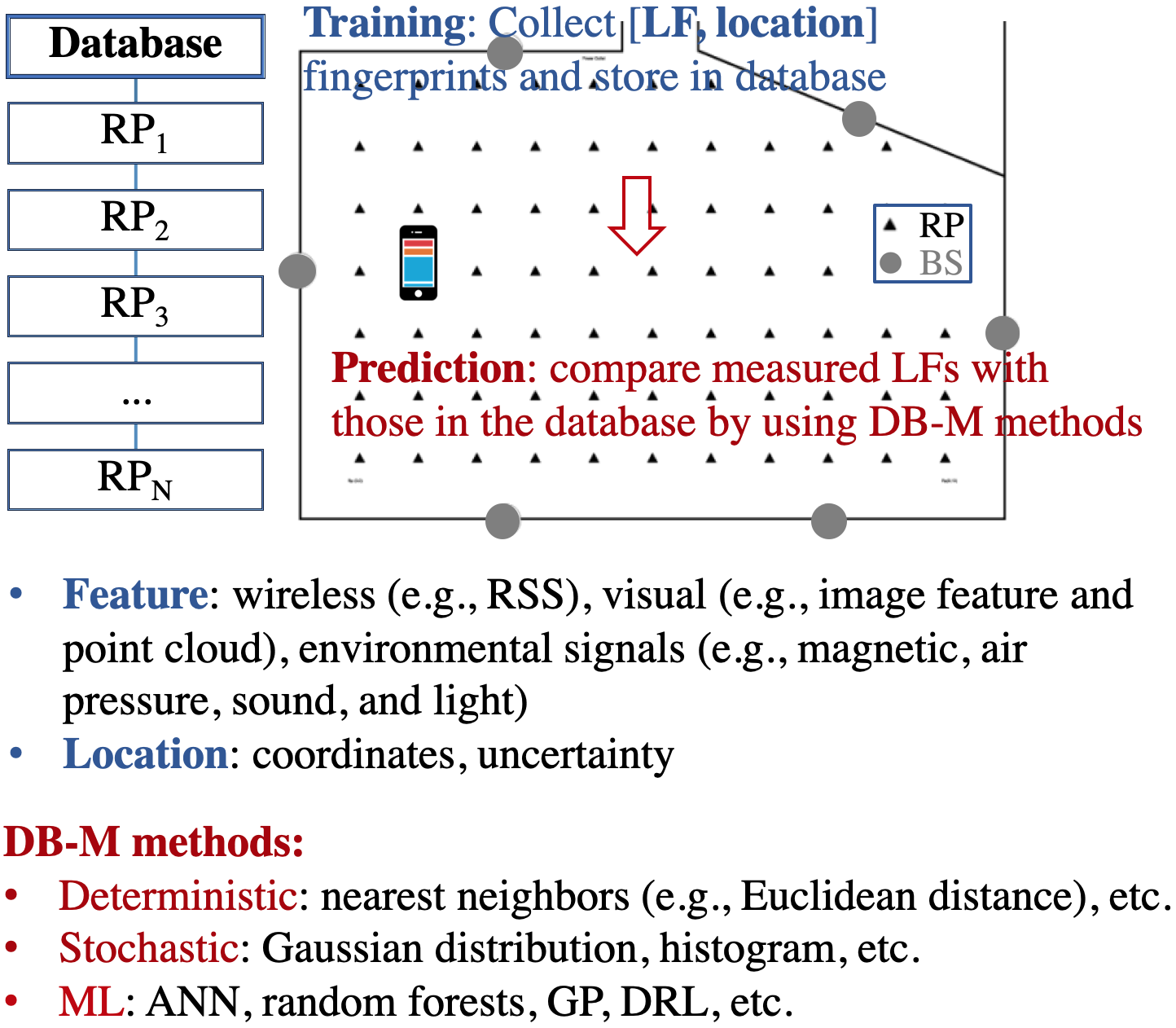
Although different localization technologies have various physical measurements and principles, they can generally be used for localization through DB-M. The basic principle for DB-M localization is to compute the difference between the measured fingerprints and the reference fingerprints in the database, and find the closest match. The DB-M process consists of three steps: (1) Localization feature (LF) extraction, (2) database training (or learning or mapping), and (3) prediction. Figure 8 demonstrates the principle of the training and prediction steps. The details of the steps are as follows.
-
•
In LF extraction, valuable LFs are extracted from raw localization signals. A valuable LF should be stable over time and distinct over space. Examples of the LFs include RSS/CSI for wireless localization, magnetic intensity for magnetic matching, and visual features for vision localization. The extracted LFs are recorded and used for training and prediction.
-
•
At the database-training step, [LF, location] fingerprints at multiple RPs are used to generate or update a database, which can also be regarded as a type of map. The database may be a data structure that stores the LFs at multiple RPs, or be the coefficients of parametric models.
-
•
At the prediction step, the real-time measured LFs are compared with the database to locate the node. The likelihood (or weight) for each RP can be computed through (a) deterministic (e.g., nearest neighbors [88]), (b) stochastic (e.g., Gaussian distribution [89] and histogram [90]), and (c) ML (e.g., ANNs [91], random forests [92], GP [93], and DRL [94]) methods. These methods are described separately in the following subsections.
III-A1 Deterministic DB-M
In these methods, only deterministic values (e.g., the mean value) of each LF at each RP are stored in the database. Thus, the LF values at each RP construct a vector, while the reference LF values at multiple RPs build a matrix. Each column vector in the matrix is the reference LF vector at one RP. At the prediction step, the similarity between the measured LF vector and each reference LF vector in the matrix is calculated by computing the vector distance. The RPs that have the highest similarity values are the nearest neighbors. To compute the similarity, the Euclidean distance [88] is widely used. Meanwhile, there are other types of vector distances, such as Manhattan distance [95], Minkowski distance [96], Spearman distance [97], and information entropy [96].
The deterministic DB-M methods have advantages of small database size and computational load. On the other hand, a main limitation is that the stochastic LFs, which may be caused by various factors in real-world practices, have not been involved.
III-A2 Stochastic DB-M
Compared to the deterministic methods, stochastic DB-M approaches introduce stochastic LFs at each RP through various methods, such as the Gaussian-distribution [89] and histogram [90] methods. Meanwhile, likelihood [99] between measured LFs and the reference ones in database is used to replace vector distance as the weight of similarity.
It is notable that the majority of related works assume that various LFs (e.g., RSS values with different BSs) are independent with one another, so as to simplify the likelihood computation to the product (or summation) of the likelihood values for all LF components. Then, the likelihood-computation problem becomes how to estimate the likelihood value for each LF component. If the Gaussian-distribution method is used, the likelihood value for a LF can be estimated by applying Gaussian-distribution model [89].
Although the Gaussian-distribution model is one of the most widely used models for stochastic errors in localization applications, there may be systematic LF measurement errors due to environmental factors. The existence of systematic errors theoretically breaks the Gaussian-distribution assumption. However, the Gaussian distribution is still widely used in engineering practices because real-world environmental factors is difficult to predict and model. One approach for reducing the degradation from systematic errors is to set relative larger variance values in localization filters to absorb the impact of such errors.
Moreover, WiFi [98] and LoRa [30] RSS values may have not only symmetric histograms but also asymmetric ones, such as left-skewed, bimodal, and other irregular histograms. Such asymmetric measurement distributions may be caused by environmental factors. An approach for mitigating the impact of asymmetric measurement distributions is to use histograms [90] or advanced stochastic models, such as those discussed in [87].
The histogram method can obtain likelihood values without assumption on signal distributions. The histograms for all LF components at all RPs are calculated in the training step. In the prediction step, the measured fingerprint is compared with the corresponding histogram to find the likelihood. However, since it determines likelihood values through histogram matching, instead of using a parametric model, it may suffer from a large database size and overfitting.
III-A3 ML-based DB-M
In recent years, ML has started to bring empowerment to numerous applications because of the increased data volume, the increased computing power, and the enhanced ML algorithms. This subsection reviews the typical ML algorithms that have been utilized for localization.
- ANN: ANN is a type of framework for using ML methods to process complex (e.g., nonlinear and non-Gaussian) data. ANN consists of one input layer, at least one hidden layer, and one output layer. Each layer contains at least one neuron. The neurons are connected via weights and biases, which are trained and stored. There are numerous publications (e.g., [100]) on the principle of ANN. Also, there are various types of ANN, such as the recurrent neural network (RNN) [101], convolutional neural network (CNN) [102], radial basis function neural network (RBF) [103], and multi-layer perceptron (MLP) [104].
As an example, MLP is used to illustrate the mechanism within ANN. MLP is a supervised-learning approach that is based on the error back-propagation algorithm, which optimizes the parameters (i.e., weights and biases) by minimizing the cost function (e.g., the sum of squared errors) of the neurons at the output layer. Specifically, the back-propagation algorithm can be divided into five steps [105]: input, feed-forward, output error computation, error back-propagation, and output. Four standard back-propagation equations [106] can be used to calculate the errors at the output layer and then back-propagate these errors to update the weights and biases based on a learning rate.
ANN techniques have been used for localization over a decade ago [107]; however, it has not been widely adopted until recent years. RSS (e.g., RSS from WiFi [108], BLE [109], ZigBee [110], RFID [111], cellular [104], and photodiode [102]), RSS features (e.g., 2D RSS map [112], differential RSS (DRSS) [103], and RSS statistics [113]), CSI [101], and AoA [114] have been used. The majority of these works directly output node locations, while the others also generate the identification of floors [113], rooms [108], and regions [115], NLoS [101], similarity of fingerprints [116], localization success rate [117], and localization accuracy prediction [91].
ANN has several advantages: (1) the algorithm has been well-developed and successfully in various fields (e.g., speech recognition [118] and image processing [119]). (2) The current ANN platforms and toolboxes are open and straightforward to use. On the other hand, the shortcomings of ANN include: (1) an ANN model is similar to a black box for most users. It is difficult to determine an explicit model representation of how the ANN works. (2) It is difficult to understand and adjust the internal algorithms. For example, although the majority of localization works above use one to three hidden layers, they set the numbers of hidden layers and neurons through brute-force data processing, instead of following a theoretical guide. Such specifically-tuned ANN parameters may be not suitable for varying localization environments.
- GP: GP is a supervised ML method for regression and probabilistic classification [120]. A GP is a set of random variables which have joint Gaussian distributions. Therefore, for localization applications, GP can involve the correlation among all RPs. This characteristic makes GP different from many other localization methods which treat each RP separately. Another characteristic for GP is that it can be uniquely determined by a mean function and a kernel function (i.e., covariance function). In the localization area, the mean function may be set by using geometrical LF models [121]; meanwhile, a zero mean function is used in some scenarios [93]. In contrast, there are various types of covariance functions, such as the constant, linear, squared exponential, Matérn, and periodic ones [120]. The geometrical LF models have not been involved in covariance functions in the existing works. The research in [123] has presented a hyperparameter estimation model for learning the GP model parameters.
The use of GP for RSS localization has been proposed in [122] for cellular networks. The paper [123] extends the work by introducing a Bayesian filter that builds on a graphed space representation. Afterwards, GP has been used in processing data from various localization sensors, such as magnetometers [17] and RFID [124]. Furthermore, GP has become one of the main techniques for localization-database prediction (or interpolation), that is, to predict LFs at unvisited or out-of-date RPs based on training data at other RPs. Reference [125] compares the performance of DB prediction by using GP and geometrical (e.g., linear, cubic, thin plate, and quintic polynomial) interpolation methods.
GP has advantages such as: (1) it has a physical meaning and an explicit model representation, compared to many other ML methods. (2) GP captures both the predicted solution and its uncertainty. The latter is not provided in ANN. (3) GP has a small number of parameters; thus, its engineering implementation is straightforward. The challenges for GP include: (1) it is based on a Gaussian-process assumption, which may be degraded in challenging localization scenarios. Integrating GP with geometrical localization models may be a possible method to mitigate this degradation [121]. (2) GP has a small number of parameters. Thus, in localization scenarios that have complex environments and massive data, GP may not be able to exploit the potential of complex databases as well as other ML methods (e.g., ANN).
- Random forests: The random forests algorithm is an ensemble classifier that uses a set of decision trees (i.e., classification and regression trees) for supervised classification [126]. The paper [127] has a detailed description on its principle and theoretical formulae. Random forests can be implemented through three steps: subsampling, decision-tree training, and prediction. In the subsampling step, the algorithm randomly selects a subsample that contains a fixed number of randomly-selected features from the original dataset. The subsample is trained with a decision in the decision-tree training step. The training process creates the if-then rules of the tree. One typical method for this process is Gini impurity [128], which is a measure of how often a randomly selected element will be incorrectly labeled if the element is randomly labeled according to the label distribution in the subset.
When splitting a branch in the tree, all possible conditions are considered and the condition with the lowest Gini impurity is chosen as the new node of the decision tree. If the split is perfect, the Gini impurity of that branch would be zero. There are other criteria (e.g., information gain [129]). For prediction, each tree in the ensemble gives a prediction result. Based on the votes from all trees, a probabilistic result can be generated.
In the localization area, the random-forest approach has been applied for RSS fingerprinting [92], CSI fingerprinting [132], vision localization [130], NLoS condition identification [5], loop-closure detection [131], and VLP [133]. The advantages of random forests include [134]: (1) compared to other decision-tree based methods, it is less sensitive to outliers in training data. (2) The random-forest parameters can be set easily. (3) Random forests can generate variable importance and accuracy together with prediction solutions. The shortcomings of random forests include: (1) it is not efficient in computational load. A large number of trees are needed for an accurate vote. This phenomenon leads to large databases and computational loads. (2) It may be over-fitted. Also, it is sensitive to noise [135].
- DRL: DRL, which is the core algorithm for AlphaGo, has attracted intensive attention. It combines deep learning and reinforcement learning. The former provides a learning mechanism, while the later provides goals for learning [136]. In general, DRL allows the agent to observe states and act to collect long-term rewards. The states are mapped to an action through a policy [94].
The DRL algorithm has experienced stages such as Deep Q-Networks (DQN), Asynchronous Advantage Actor-Critic (A3C), and UNsupervised REinforcement and Auxiliary Learning (UNREAL). Specifically, DQN [137] introduces value networks to represent the critic module, and constructs value networks according to specific applications by using ANNs (e.g., Long Short-Term Memory (LSTM) networks and CNN). Then, A3C [138] applies the actor-critic framework and asynchronous learning. The basic idea of actor-critic is to evaluate the output action and tune the possibility of actions based on evaluation results. Compared to A3C, the UNREAL algorithm is closer to the human-learning mode. Specifically, UNREAL enhances the actor-critic mechanism through multiple auxiliary tasks. The research in [139] has pointed out three components for a DRL solution: basis/core (e.g., state definition, action definition, and reward definition), basic units (e.g., Q-network, action selection, replay memory, and target network), and state reformulation (i.e., the method for state-awareness data processing).
DRL has been used for navigation in Atari games [137], mazes [140], and the real world [141]. Meanwhile, DRL has been applied for navigation using data from monocular camera [141], 360-degree camera [142], LiDAR [143], magnetic sensor [144], wireless sensor [145], and Google street view [146]. Many of the recent DRL research works focus on navigation without a map [143], in new environments [147], and with varying targets [148]. However, most of these methods are designed for navigation, instead of localization. Navigation and localization both use data from wireless, environmental, and vision sensors as inputs, they have different principles. Navigation is the issue of finding the optimal motion path between the node and a target location; in contrast, a localization module outputs the node location. It is straightforward to model a navigation process as a Markov decision process; thus, it can be processed by DRL. By contrast, localization is closer to a deep learning problem.
The advantages of DRL include: (1) it can obtain not only the optimal solution at the current moment, but also the long-term reward. (2) DRL can reduce the computational complexity caused by re-optimization due to factors such as environment changes [139]. The challenges of DRL include: (1) the set of reward definition is key to the DRL performance. However, it is challenging to determine a theoretical model for reward definition. (2) The DRL algorithm itself has met several challenges [149], such as hyperparameter sensitivity, sample efficiency, off-policy learning, and imitation learning. (3) The future DRL algorithms may need supports from ML chips due to their large computational loads.
There are also other ML methods for enhancing localization. For example, the Hidden Markov Model (HMM) approach has been used for RSS fingerprinting [150], trajectory modeling [151], and room recognition [152]. Also, the Support Vector Machine (SVM) method has been applied for CSI localization [153], RSS localization [154], and wide-area localization [155]. Meanwhile, the fuzzy-logic method has been used for smartphone localization [156] and VLP [157]. Various ML methods have different advantages and thus are suitable for different localization use cases.
III-B Geometrical Localization Methods
Geometrical localization methods have been researched for decades. To use such methods, BS locations are commonly known or can be estimated. The main measurements are BS-node distances and angles. The main localization methods include multilateration, hyperbolic localization, multiangulation, multiangulateration, and other simplified methods such as min-max, centroid, and proximity. Previous survey papers [2] and [36] already have detailed descriptions on these methods. Thus, this survey only summarizes their main characteristics. Figure 9 illustrates the principle of several geometrical localization methods.
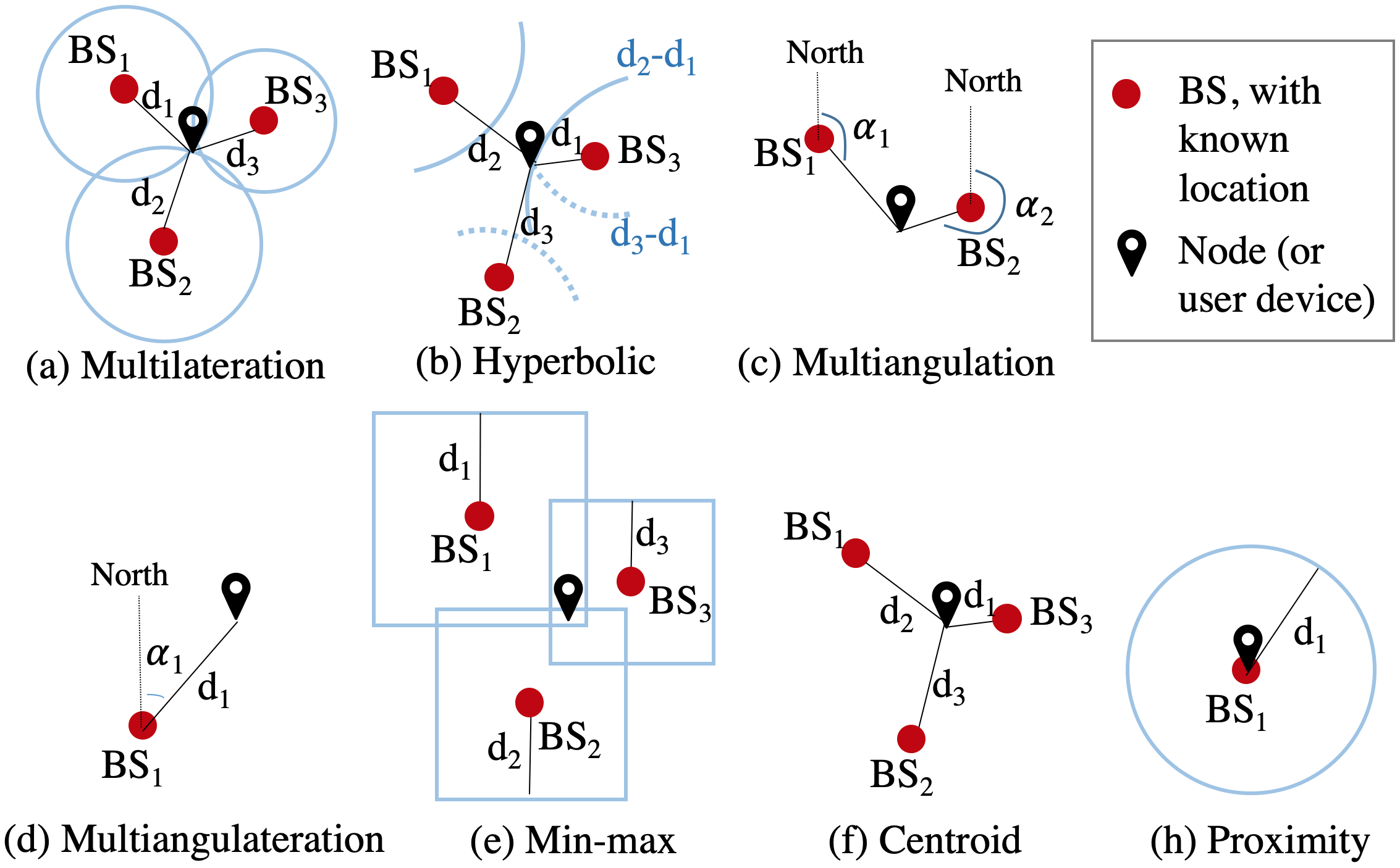
III-B1 Multilateration
Multilateration can be used to estimate node location by using locations of at least three BSs and their distances to the node. Its basic principle is to estimate the intersection between spheres (for 3D localization) and circles (for 2D localization). This method has been widely used in GNSS and wireless Ad Hoc network node [158] or BS [159] location estimation. The common estimation techniques are least squares and Kalman filter (KF). The multilateration performance may be enhanced through improving ranging accuracy by mitigating the impact of environment-related and receiver errors [160]. There are also well-developed blunder-detection and accuracy-evaluation mechanisms [161] as well as geometry indicators such as the Dilution of Precision (DOP) [163].
III-B2 Hyperbolic Localization
Hyperbolic localization, which was developed for Loran navigation [165], is the main method for TDoA localization. It is based on the distance differences between the node and various BSs. Because hyperbolic localization has eliminated the requirement for precise timing on nodes, it has strong potential for LPWAN localization. There is also accuracy analysis [67] for this method.
III-B3 Multiangulation
Multiangularation can be implemented by measuring the angles between the node and at least two BSs [68]. Theoretically, two BS-node angles can determine a 2D point. When considering angle-measurement errors, a quadrangle can be determined. The multiangulation method has been used in wireless Ad Hoc networks to reduce the requirement on BS (or anchor) locations [166]. The performance analysis of multiangulation has also been provided [70].
III-B4 Multiangulateration
Multiangulateration localizes a node by at least one BS-node angle and one BS-node distance. This method has been widely used in traverse networks in engineering surveying [167]. For indoor localization, it is feasible to use one AoA (e.g., VLP [36] and BLE [69]) BS on the ceiling with known height for localization.
III-B5 Min-Max
Min-max is a variant of multilateration. Its geometrical principle is to calculate the intersection between cubes (for 3D localization) and squares (2D localization), instead of spheres and circles. The benefit for using cubes and squares is that their intersections can be directly computed through deterministic equations [168], which have significantly lighter computational loads than least squares. The limitation of min-max is that it has not considered the stochastic measurements. Meanwhile, compared to spheres, cubes deviate from spatial distribution with a certain BS-node distance. The min-max method can be used to generate coarse localization solutions [169], which provide initial positions for fine-localization approaches such as multilateration.
III-B6 Centroid
Centroid is a simplification of multilateration. It estimates the node location by weighted average of the locations of various BSs. The weights for BS locations are commonly determined by BS-node distances [170]. Similar to min-max, the centroid has a low computational load but has not considered stochastic measurements. Furthermore, the centroid result will be limited within the region that has a boundary formed by BS locations. Similar to min-max, the centroid is commonly used for coarse localization.
III-B7 Proximity
Proximity can be regarded as a further simplification of the centroid approach. The possible location region is determined by using the location of one BS as the circle center and using the BS-node distance as the radius. Proximity is commonly used in RFID [171] and cell-identification [172] localization. The method has the lowest computational load, the lowest number of BS, but the largest location uncertainty. Thus, it is commonly used for near-field localization, coarse localization, or for bridging the outages when the other localization methods do not have sufficient BSs.
III-C Summary and Insight on Database-Matching and Geometrical Localization Methods
DB-M and geometrical localization methods have several similarities, such as
-
•
Both methods have the training and prediction steps. In DB-M methods, a [LF, location] database is generated through training; in contrast, in geometrical methods, the coefficients for parametric models are estimated and stored at the training step.
-
•
They have some common error sources, such as device diversity, orientation diversity, and human-body effects.
On the other hand, these methods have differences (or complementary characteristics), such as
-
•
Geometrical methods are more suitable for scenarios (e.g., outdoor and indoor open environments) that can be explicitly modeled and parameterized. In contrast, DB-M approaches are more suitable for complex scenarios (e.g., wide-area urban and indoor areas) that are difficult to be parameterized.
-
•
For geometrical methods, environmental factors such as NLoS and multipath conditions are error sources that need to be modeled and mitigated. By contrast, DB-M methods may use the measurements of these factors as fingerprints to enhance localization.
-
•
Geometrical methods are based on parametric models; thus, the databases contain only model parameter values and thus are relatively small. On the other hand, it is difficult to describe complex scenarios by using parametric models with limited numbers of parameters. In contrast, DB-M methods directly describe localization scenarios by using data at all points in the space; thus, both database and computational loads are large, especially for wide-area applications. However, DB-M approaches have more potential to provide higher resolution and more details on complex localization scenarios.
-
•
Progresses in ML algorithms have brought great potential to localization methods, especially for the applications that have complex scenarios that are difficult to model, parameters that are difficult to determine and tune, and have nonlinear, non-parametrical, correlated measurements that are caused by environmental and motion factors. Although ML methods are classified into the DB-M group in this survey according to the existing works, ML can also be used to enhance geometrical localization, such as training of parametric models and their parameters.
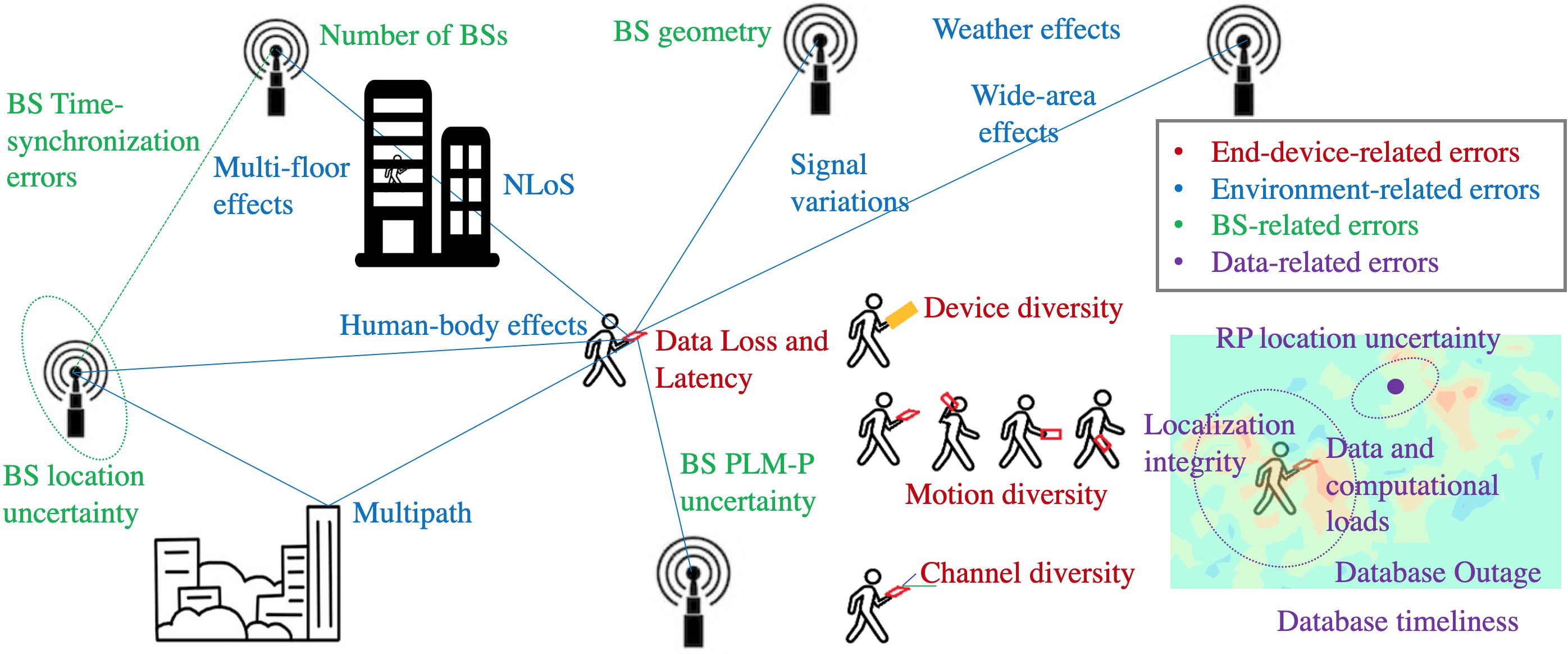
Due to their complementary characteristics, geometrical and DB-M methods can be integrated. For example, geometrical methods can be used to reduce the computational load of DB-M [176], to aid database prediction [121], and to provide localization uncertainty prediction [99]. It is also feasible to directly integrate geometrical and DB-M methods for more robust localization solutions [177].
IV IoT Localization Error Sources and Mitigation
This section describes the main IoT-localization error sources and their mitigation. These two topics are key components in a LE-IoT system. This section answers two questions: (1) what are the error sources for IoT localization; and (2) how to mitigate or eliminate the impact of these error sources. The localization error sources are classified into four groups as
-
•
End-device-related errors: device diversity, motion/attitude diversity, data loss and latency, and channel diversity.
-
•
Environment-related errors: multipath, NLoS, wide-area effects, multi-floor effects, human-body effects, weather effects, and signal variations.
-
•
Base-station-related errors: the number of BSs, BS geometry, BS location uncertainty, BS PLM-P uncertainty, and BS time synchronization errors.
-
•
Data-related errors: database timeliness/training cost, RP location uncertainty, database outage, intensive data, data and computational loads, and localization integrity.
Figure 10 shows the main IoT-localization error sources. The details for the listed error sources are provided in the following subsections.
IV-A End-Device-Related Errors
This subsection introduces the error sources on the node side. The error sources include device diversity, motion/attitude diversity, data loss and latency, and channel diversity.
IV-A1 Node (Device) Diversity
A large numbers of low-cost MEMS sensors are used in IoT nodes. Such low-cost sensors may have diversity when measuring the same physical variable. For example, the RSS diversity for the same-brand BLE nodes may reach 20 dBm [178]. Such node diversity directly leads to localization errors [178].
To alleviate the impact of node diversity, there are calibration-based methods that fit data from multiple nodes through the use of histograms [179], least squares [180], ANNs [181], multi-dimensional scaling [183], and motion states from DR [182]. Reference [84] provides details about several node-diversity calibration methods, such as nonlinear adjustment, sensitivity threshold correction, and interdependence across BSs.
Meanwhile, there are calibration-free differential-measurement-based approaches. Examples of such methods include the differential approach that subtracts the data from a selected datum BS from those from the other BSs [184], takes the differences between data from all BS couples [185], uses the average data from all BSs [186] or selected BSs [187] as the datum, and adopts the advanced datum-selection method [188]. Additionally, differential measurements are used in multilateration [189] and other geometrical [190] methods. There are two challenges for using differential signals: (1) it is challenging to switch the datum for differential computation in a wide-area IoT application. (2) The differential computation increases the noise levels in measurements.
IV-A2 Motion/Attitude Diversity
IoT nodes may experience various motion modes, such as being held horizontally, dangling in the hand, mounted on chest, and stored in pockets or bags. This phenomenon leads to changes in node attitude (or orientation). Meanwhile, movements of nodes also lead to changes in the relative attitude angles between node- and BS-antenna directions. Such attitude changes lead to localization errors [178].
To reduce the impact of motion/attitude diversity, the research in [195] proposes a compass-aided method by using attitude-matched databases; furthermore, the paper [196] extends the method to dynamic localization scenarios. Meanwhile, the papers [193] and [194] present a heading-aided methods that add the node attitude into fingerprints and decision trees, respectively. Moreover, reference [197] uses histogram equalization for orientation-effect compensation, while the research in [178] presents an orientation-compensation model to compensate for orientation diversity.
The orientation angles of BS antennae are commonly constant, while the node attitude angles are dynamic and can be estimated in real time through the Attitude and Heading Reference System (AHRS) algorithm [198]. In such an algorithm, gyro measurements are used to construct the system model, while accelerometer and magnetometer data provide measurement updates. Meanwhile, autonomous gyro calibration is important to enhance attitude estimation [19].
IV-A3 Data Loss and Latency
Response rate is a practical factor in wireless localization. Data from some BSs may be wrongly missed in the scanning duration [199]. Also, the response rate may vary across BSs and are related with the level of signals [199]. BSs with lower RSS values tend to have lower response rates. The response rate can also be used as fingerprint information [200].
Meanwhile, to meet the requirement of low power consumption, IoT nodes commonly have low sampling rates. Furthermore, the existence of massive numbers of nodes may lead to data collision, loss [62], and latency [201]. Both data loss and latency may directly lead to localization errors. In particular, the loss or delay of data from an important BS (e.g., a BS that is geographically close to the node) [202] may lead to significant degradation on localization performance.
A possible method to mitigate this issue is to predict localization signals by using approaches such as time-series analysis [203] and ML [204]. Furthermore, data from other localization sensors or vehicle-motion constraints may be used to construct node-motion models, which can be used for localization-signal prediction.
IV-A4 Channel Diversity
In IoT applications, especially those with a high node density (e.g., in animal-husbandry applications), multi-channel mechanisms may be utilized to reduce data collision [204]. The difference between training and prediction data channels may lead to localization errors. To alleviate such errors, one method is to calibrate channel diversity through parametric models [205] or ML [204]. Meanwhile, data from multiple channels may be combined [206] or treated as data from various BSs [207] to enhance localization.
IV-B Environment-Related Errors
This subsection describes the environment-related localization error sources, including multipath, NLoS, wide-area effects, multi-floor effects, human-body effects, weather effects, and signal variations.
IV-B1 Multipath
Multipath is a common issue when using wireless signals, especially in indoor and urban areas. It is difficult to discriminate between multipath propagations and the direct path. There are papers that evaluate the impact of multipath in localization. For example, the paper [208] compares the impact of multipath on AoA and PoA methods with a photodiode and found that AoA localization was affected by an order of magnitude lower than PoA. Meanwhile, the research [209] has investigated the impact of multipath on RSS and CSI localization and found that CSI localization suffered from less degradation. In the localization area, the research on multipath are mainly on two aspects: mitigating its degradation on localization solutions and using it to enhance localization.
There are various methods for mitigating the degradation from multipath. Some research reduce multipath errors by using specific node design, such as adopting antenna arrays [210], beamforming [212], frequency-hopping [212], a modified delay locked loop [213], and multi-channel signals [206]. Meanwhile, there are approaches for distinguishing the direct path from multipath reflections [214] and extracting individual multipath propagation delays [215]. Using 3D city models to assist multipath detection, which is a combination of localization and mobile mapping, has also been researched [216] in recent years. Furthermore, some papers focus on modeling the multipath components by using different Path-Loss Models (PLMs) for direct-path and multipath signals [217], involving multipath components in PLMs [218], and estimating multipath parameters in real time by using SLAM [219] and Extended KF (EKF) [220] algorithms.
Moreover, due to the new features such as MIMO, dense minimized BS, and mmWave systems in 5G, using multipath signals to enhance localization is attracting research interest. The research in [221] describes the principle and methodology for multipath-assisted localization. Meanwhile, reference [6] has derived the statistical performance bounds and evaluation models, while the paper [222] derives the Cramér-Rao lower bound (CRLB) for multipath-assisted localization. Multipath-assisted localization has been utilized in outdoor [223] and indoor [224] single-BS systems. Moreover, the research in [225] treats multipath components as signals emitted from virtual transmitters and uses them to assist localization within a SLAM algorithm, while the paper [226] improves the accuracy of RSS fingerprinting by introducing multipath-sensitive signal features. Furthermore, there are approaches that directly use multipath signals for DB-M [227] and multilateration [228] computation.
IV-B2 NLoS
Similar to the multipath effect, the NLoS effect is an important error source for wireless localization. Actually, NLoS is one factor that will cause multipath propagation. This subsection focuses on other effects of NLoS. It has been revealed that NLoS environments may significantly reduce the coverage range of IoT signals [229] and change their PLM-P values [62]. The paper [230] investigates the effect of NLoS signals on RSS localization and attempts to quantify the relation between localization errors and NLoS, while the research in [231] derives the NLoS-based CRLB. In general, the research on NLoS can be classified into three groups: identification, modeling, and mitigation.
To identify NLoS signals, algorithms such as ANN [232], random forests [5], SVM [233], the Dempster-Shafer evidence theory [234], and the Neyman-Pearson test [235] have been applied. There is also a method that detects NLoS by comparing the difference between signals in multiple frequency bands [236].
Examples of NLoS-modeling approaches include that use advanced PLMs involving walls [238] and building floors [63]. Furthermore, there are research that have considered the thickness of obstacles and intersection angles between obstacles and the direct path [239] as well as the wall and interaction loss factors [160].
To mitigate the NLoS effect, there are methods that use various estimation techniques, including Monte-Carlo Gaussian smoothing [240], residual analysis [241], least trimmed squares [242], and improved filtering techniques, such as the cubature KF [243], skew-t variational Bayes filter [244], Particle Filter (PF) [245], Unscented KF (UKF) [246], finite impulse response filter [247], and biased KF [248]. Advanced models (e.g., the radial extreme value distribution model [249]) have also been used. Furthermore, it is feasible to realize NLoS mitigation by introducing external localization sensors, such as vision [250] and inertial [251] sensors.
IV-B3 Wide-Area Effects
Wide-area localization is more challenging than local localization due to factors such as lower RSS, SNR, and response rate values [30], and stronger multipath and fading effects [252]. Moreover, it is challenging to obtain wide-area PLM-P values because they change significantly with factors such as environment type (e.g., highway, rural, and urban) [253], terrain category (e.g., hilly, flat, with light/moderate/heavy tree densities, and on water/ground) [254], and even BS-node distances and BS antenna heights [7].
Advanced PLMs have been used to enhance wide-area localization. Example of these PLMs include the multi-slope PLM for BS-node distances from meters to hundreds of meters [255], the higher-order PLM [61], and the height-dependent PLM [256]. ML methods (e.g., ANN) have been used to determine the PLM-P values [257]. Meanwhile, there are other improved wide-area localization algorithms, such as the BS-identity [252] and minimum-mean-square-error [258] ones. Considering the popularization of small BSs, it may become a trend to use wide-area IoT signals for coarse positioning and use local IoT signals for fine localization.
IV-B4 Multi-Floor Effects
Most of the existing works are focusing on 2D localization. However, in the IoT era, nodes may be used in 3D scenarios. A practical 3D-localization approach is to find the floor at which the node is located and then localize the node in the floor. Thus, robust floor detection is required. For this purpose, researchers have used data from various sensors, such as wireless sensors [113], a barometer [259], inertial sensors [261], a floor plan [260], and a user-activity probability map [262]. There are also various estimation techniques, such as KF [259], PF [260], and ANNs [113]. The impact of multi-floor effects on PLM-P values has also been researched [63].
IV-B5 Human-Body Effects
It is necessary to consider the human-body effect in some IoT-localization applications, especially when the nodes are placed on the human body. There are four types of research on the human-body effect: evaluation, modeling, mitigation, and utilization.
There are papers that evaluate the impact of the human body on multilateration [263], centroid [264], and several other localization algorithms [265]. It has been found that the human body may cause degradation on localization; also, the degradation is more significant when the node is carried on human body, compared to the use case when a human blocks the BS-node LoS [264]. Meanwhile, the research [9] has revealed that influence of the human-body effect varies with the node position and orientation. Also, the tests in [226] show that the human body leads to short-term RSS fluctuations, instead of long-term signal shifts.
There are approaches for modeling the human-body effect. For example, the literature [267] models the impacts on both ToA ranging and localization. Also, the paper [9] presents a compensation model for the human-body effect by introducing the user orientation toward fixed infrastructure. For modern localization applications, it may be feasible to use other sensors, such as vision, to detect the human body and compensate for its effect.
Moreover, to mitigate the human-body effect, the research in [266] treats it as a NLoS signal and mitigates its effect by using NLoS-mitigation methods. Also, the paper [9] combines the data from multiple nodes at different places on a human body to control the human-body effect.
Furthermore, human-body effects have been utilized for device-free localization [268]. Signals such as range [269], RSS [270], CSI [271], and AoA [272] are used. Moreover, there are other works that use the human-body effect for activity recognition [273], fall detection [274], and people counting [275].
IV-B6 Weather Effects
Researchers have studied the weather effect on wireless signal propagation. Theoretically, large-wavelength wireless signals are not susceptible to external factors, such as precipitation and vegetation [276]. Meanwhile, the research in [226] indicates that FM RSS has a weak correlation with temperature, relative humidity, air pressure, wind speed, and aviation-specific runway visibility. The research has not considered weather-dependent environment changes such as movements of trees and power-line wires as well as changes of ground conductivity and the multipath effects.
However, on-site experimental results in [277] show that variations in rain conditions and wind speeds significantly degraded accuracy in distance estimation using Global System for Mobile communication (GSM) RSS. Meanwhile, reference [254] shows that LoRa RSS measurements suffer from significant noise and drifts when operating near lakes. Thus, whether the weather change has a significant impact on a certain type of IoT signal need specific evaluation. Meanwhile, integrating IoT signals with self-contained localization technologies, such as INS, may reduce the weather impact on positioning solutions.
IV-B7 Signal Variations
Fluctuations is an issue inherent to wireless signals, especially for those in indoor and urban areas. The LoRa RSS variation can reach several dBm and over 10 dBm under static and dynamic motions, respectively [30]. Although signal variations cannot be eliminated, their effects can be mitigated through denoising methods such as averaging [278], autoregressive [279], wavelet [280], KF [281], and ANN [282].
Many denoising methods assume the noise follows a Gaussian distribution. However, both LoRa [30] and WiFi [98] RSS variations can follow either symmetric or asymmetric distributions. To model an irregular distribution, stochastic-signal analysis methods such as Allan variance [86] and multisignal wavelet variance [87] can be used.
IV-C Base-Station-Related Errors
Examples of localization error sources on the BS side include insufficient number of BSs, poor geometry, BS location uncertainty, BS PLM-P uncertainty, and BS time synchronization errors.
IV-C1 Number of BSs
Public telecommunication and IoT BSs are mainly deployed for communication, instead of localization. Communication uses require signals from at least one BS, while localization needs signals from multiple BSs. Thus, the dependence on the number of BSs is a challenge for telecommunication- and IoT-signal based localization. To alleviate this issue, there are several approaches, such as using single-BS localization techniques, adding motion constraints, choosing localization algorithms that need fewer BSs, and integration with other sensors.
Single-BS localization techniques can be conducted by using various measurements, such as ToA, AoA, and RSS. Similar to multi-BS localization, ToA [283] and AoA [284] based localization may provide high-accuracy locations but require professional nodes for distance and angle measurements, respectively. RSS-based single-BS localization can also be implemented through either DB-M [285] or parametric-model-based methods [71]. Compared to multi-BS localization methods, single-BS localization has great potential to be used in existing telecommunication systems but face new challenges, such as the difficulty to detect outliers in its results [71].
To mitigate this issue, other approaches are needed. First, adding motion constraints can reduce the requirement for localization-signal measurements. For example, adding a constant-height constraint can reduce one state to be estimated [161]. Meanwhile, coarse-localization algorithms (e.g., min-max, centroid, and proximity) require localization signals from less BSs. Furthermore, it is feasible to fuse wireless signal measurements with data from other sensors (e.g., inertial and vision sensors) for tightly-coupled localization [162].
IV-C2 BS Geometry
The wireless-localization performance is directly correlated with BS geometry. The research in [286] and [160] investigate BS location optimization from the indoor communication and multi-floor signal coverage perspective, respectively. In the localization field, poor BS geometry may lead to the problem of location ambiguity [199]. The relation between BS geometry and localization performance has been investigated through simulation [287] and field testing [288]. Furthermore, there are indicators, such as DOP [163], to quantify the geometry. DOP can be used to predict the multilateration accuracy given BS locations. A small DOP value is a necessary condition for accurate multilateration.
On the other hand, a small DOP value is not a sufficient condition for accurate localization because DOP can reflect only the geometrical BS-node relation, instead of many other error sources, such as NLoS, multipath, and stochastic errors. Therefore, other approaches for BS location optimization have been presented. For example, the research in [289] combines DOP and a floor plan to address the problem. Meanwhile, there are methods for BS-geometry evaluation and optimization through CRLB analysis [290] and the Genetic algorithm [291]. The research in [292] analyzes the influence of BS geometry on indoor localization and has involved the impact of obstacles. According to the existing works, it is worthwhile to evaluate the BS geometry in advance and optimize it based on the actual localization environment.
In the future, more BSs will become available for localization due to the popularization of small IoT BSs. The existence of more BSs is generally beneficial for localization; however, too many BSs may increase the complexity of location estimation. For example, if several BSs are located in close proximity, a location ambiguity problem may occur around the region in which these BSs are located. Thus, it is also necessary to use BSs selectively based on their importance. The research in [202] quantifies the importance of each BS by the signal discrimination between distinct locations. Meanwhile, the paper [293] examines several BS-selection criteria, such as the Kullback-Leibler divergence, dissimilarity, maximum value, and entropy. The literature [294] adds more criteria, including the number of RPs, the average, and variance values. Moreover, there are BS-selection approaches through the use of theoretical-error analysis [295], adaptive cluster splitting [296], and strong-signal detection [297]. Meanwhile, the research in [298] investigates optimal BS selection through a tradeoff btween localization accuracy and energy consumption.
IV-C3 BS Location Uncertainty
Geometrical localization methods commonly need known BS locations, a requirement which cannot be met in many IoT applications. To solve this issue, BS-localization approaches have been researched. The literature [159] reflects the idea of estimating the locations of BSs by using their distances to multiple RPs that has known locations. The research in [299] improves the accuracy of BS localization by using RSS gradient. Meanwhile, there are improved BS-localization methods by using particle-swarm optimization [300], Fresnel-zone identification [301], and recursive partition [302]. The BS-localization methods have been applied in 5G mmWave systems [303], Ad-Hoc networks [166], and cooperative-localization systems [304]. Meanwhile, the literature [305] estimates BS PLM-P values before BS-location determination.
Another challenge is that the locations of IoT BSs may change, which cause localization errors. Thus, SLAM (e.g., Foot-SLAM [306] and Fast-SLAM [307]) and crowdsourcing-based methods (e.g., [199]) have been applied to estimate node and BS locations simultaneously. Meanwhile, there is research that involves the changes of BS locations in node localization [308].
IV-C4 BS Path-Loss Model Parameter Uncertainty
To achieve accurate RSS-based ranging and geometrical localization, BS PLM-P values are commonly estimated. The SLAM [307] and crowdsourcing [199] methods estimate PLM-P values simultaneously with BS locations. Meanwhile, there are other PLM-P estimation methods, such as those based on geometrical probability [309], the finite-difference time-domain technique [310], and the Cayley-Menger determinant [311]. Also, there are improved estimation techniques such as the closed-form weighted total least squares [312] and PF [313]. The papers [314] and [315] have derived the CRLB and hybrid CRLB models for PLM-P estimation errors, respectively.
Meanwhile, to enhance the ranging and localization performance, researchers have applied advanced PLMs, such as the third-order polynomial long-distance PLM [316], its combination with Gaussian models [317], and the models that involve signal degradation by walls, floors, and topological features [318]. Furthermore, specific localization signals are introduced to improve PLM-P estimation. For example, the research in [319] introduces the measurements of the Doppler effect, while [302] adds extra directional detection hardware. Moreover, the research in [320] implements dynamic PLM-P estimation in cooperative localization, while the literature [321] performs BS selection simultaneously with PLM-P estimation.
IV-C5 BS Time-Synchronization Errors
The BS timing-synchronization error is a practical and important error source for time (e.g., ToA, TDoA, and RTT) based localization methods. The research in [59] investigates multiple wired and wireless time-synchronization approaches and the relation between BS time-synchronization errors and localization errors, while the research in [322] evaluates several wireless time-synchronization approaches for indoor devices. Also, the literature [323] examines the degradation in localization accuracy caused by time-synchronization errors through the CRLB analysis under Gaussian noise, while the paper [324] derives the CRLB for TDoA localization when multiple BSs subject to the same time-synchronization error.
IV-D Data-Related Errors
IoT localization systems also meet challenges at the data level. Examples of such challenges include those for database timeliness and training cost, RP location uncertainty, database outage, intensive data, data and computational loads, and the degradation of localization integrity in challenging environments.
IV-D1 Database Timeliness/Training Cost
To maintain localization accuracy in public areas, periodical database update is required. The most widely used database-training method is to collect data at every RP. Such a method can improve database reliability by averaging LFs at each RP [325]. However, the static data-collection process becomes extremely time-consuming and labor-intensive when dense RPs are needed to cover a large area [326]. To reduce time and manpower costs, dynamic-survey methods have been applied through the use of landmarks (e.g., corners and intersections with known positions and corridors with known orientations) on floor plans and a constant-speed assumption [327] or DR solutions [336]. To further reduce user intervention, there are other types of database-update methods based on crowdsourcing [328] or SLAM [329]. The research in [330] divides crowdsourcing approaches to active and passive ones. The former allows users to participate in the database-updating process, while the latter is an unsupervised method which completes data uploading and processing automatically without user participation. A challenge for crowdsourcing is to obtain robust RP positions, which is discussed in the next subsection.
IV-D2 RP Location Uncertainty
The uncertainty in RP locations will lead to drifts in localization databases. In particular, for dynamic-survey or crowdsourcing based localization database training, it is difficult to assure the reliability of RP locations. DR can provide autonomous localization solutions [18]; however, it is challenging to obtain long-term accurate DR solutions with low-cost sensors because of the existence of sensor errors [19], the requirement for position and heading initialization, and the misalignment angles between the vehicle (e.g., the human body) and the node [20]. Thus, constraints are needed to correct for DR errors. Vehicle-motion constraints, such as Zero velocity UPdaTes (ZUPT), Zero Angular Rate Updates (ZARU), and Non-Holonomic Constraints (NHC) [23], are typically adopted. However, these motion constraints are relative constraints, which can only mitigate the drifts of DR errors, instead of eliminating them. Absolute constraints, such as GNSS position [99] and user activity constraint [328] updates, can be used to ensure the quality of DR solutions in the long term. However, such position updates are not always available in indoor environments.
From the perspective of geo-spatial big data, only a small part of crowdsourced data is robust enough for updating databases. Thus, the challenge becomes how to select the crowdsourced data that have the most reliable DR solutions. Reference [330] presents a general framework for assessing sensor-data quality. This framework contains the impact of multiple factors, such as indoor localization time, user motion, and sensor bias. The research in [99] enhances this framework and introduces stricter quality-assessment criteria.
IV-D3 Database Outage
To obtain a reliable database, sufficient training data are required for all accessible areas. However, such a requirement is difficult to meet in wide-area applications [331]. If there is an outage of databases in certain areas, it will be impossible to locate the user correctly with traditional DB-M methods. To mitigate the database-outage issue, geometrical interpolation (e.g., mean interpolation [15], inversed distance weighted interpolation [332], bilinear interpolation [333], and Kriging interpolation [334]) and ML methods (e.g., GP [123] and support vector regression [335]) have been presented for DB prediction, that is, predicting LFs at arbitrary locations based on training data at other locations. The research in [125] compares the performance of DB prediction by using GP and geometrical interpolation methods such as linear, cubic, and thin plate interpolation. Furthermore, as demonstrated in [121], the combination of geometrical and ML-based methods may provide database-prediction solutions with higher accuracy and resolution.
IV-D4 Data and Computational Loads
The localization database becomes large in wide-area loT applications. This phenomenon brings three challenges: large data load, large computational load, and potentially large mismatch (i.e., the node is localized to a place that is far from its actual position) rate. Therefore, for wide-area IoT localization, a coarse-to-fine localization strategy can be used. The coarse-localization solutions from algorithms such as min-max, centroid, and proximity may be used to limit the search region for fine localization. A practical strategy is to use LPWAN or cellular signals for coarse localization and use local wireless (e.g., WiFi, BLE, and RFID) signals for fine localization. Meanwhile, there are other methods that use wireless signals for coarse localization and use magnetic measurements for fine localization [336].
Furthermore, region-based algorithms can be applied to reduce the search space within the database. Examples of these algorithms include region division [337], correlation-database filtering [338], genetic algorithms [338], and timing advanced-based algorithms [339]. Region-based algorithms can effectively reduce the data and computational loads. On the other hand, correct region detection and handover between adjacent regions are key for region-based methods.
IV-D5 Localization Integrity
The integrity of localization solutions, which describes the consistency between actual localization errors and the estimated localization uncertainty, is even more important than the localization accuracy. To be specific, it may be difficult to provide accurate localization solutions due to the limitation of physical environment. At this time, the localization system should be able to output an accurate indicator of the location uncertainty, which makes it possible to reduce the weight of an inaccurate localization result.
However, most of the widely-used DB-M approaches do not have an indicator for the uncertainty of location outputs. Also, DB-M methods such as random forests and GP can only provide an indicator for relative probability (i.e., the probability of the selected RPs compared to other RPs), instead of the absolute location uncertainty. In contrast, geometrical methods have theoretical location-accuracy prediction indicators such as DOP [163], CRLB [164], and observability [341]. However, these indicators have not involved many real-world error sources, such as the environment-related and motion-related errors. This phenomenon leads to poor localization integrity. For example, smartphones may provide over-estimated GNSS location accuracy when a user stands at indoor window areas. The reason for this phenomenon is that the device can actually receive an enough number of wireless signal measurements but has not detected the presence of environment-related errors such as multipath.
Thus, assuring location integrity for IoT systems is challenging but important. In particular, the future IoT systems will have a higher requirement on scalable localization, which is less dependent on the human perception and intervention. Thus, the existing localization solutions, which do not have an accuracy metric, will limit the promotion of localization techniques in IoT.
To predict the uncertainty of localization solutions, both field-test [342] and simulation [343] methods are utilized to localize the node and compare with its reference locations. Meanwhile, since IoT signals are susceptible to environmental factors, data from other localization sensors (e.g., inertial sensors) can be used to detect unreliable wireless signal measurements through adaptive KFs based on variables such as residuals [345] and innovations [344]. Furthermore, to enhance localization-uncertainty prediction for wireless localization, mathematical model [99] and ML [91] based methods can be used. However, it is still a challenge to assure localization integrity in indoor and urban areas due to the complexity and unpredictability of localization environments.
| End-device-related errors | |
| Node (Device) Diversity | • Calibration-based methods: least squares [180], histograms [179], ANN [181], multi-dimensional scaling [183], integration with DR [182], nonlinear adjustment, and sensitivity-threshold correction [84]. • Calibration-free methods #1: real-time estimation through crowdsourcing [191] and SLAM [192]. • Calibration-free methods #2: use differential measurements such as pairwise difference [185], signal strength difference [184], mean difference [186]; use advanced datum BS selection [188], and averaged measurements from selected BSs [187]; use differential measurements in multilateration [189] and other geometrical [190] methods. |
| Motion/Attitude Diversity | • DB-M based approaches: attitude-appended fingerprints [193] and decision trees [194], magnetometer-aided databases[195], and dynamic AHRS-aided databases [196]. • Combination of DB-M and parametric models: attitude compensation through histogram equalization [197]. • Parametric model based methods: orientation-compensation model [178]. |
| Data Loss and Latency | • Predict localization signals: time-series analysis [203], multi-channel mechanisms [204], and ML [204]. • Evaluate and control impact of data loss [62], lagency [201], response rate [199][200], especially those for important BSs [202]. |
| Channel Diversity | • Calibrate channel diversity through parametric models [205] and ML [204]. • Data from multiple channels may be combined [206] or treated as data from various BSs [207]. |
| Environment-related errors | |
| Multipath | • Multipath detection: direct-path and multipath separation [214], multipath-delay extraction [215], and 3D city model assisting [216]. • Multipath modeling: different PLMs for direct-path and multipath signals [217], multipath components in PLMs [218], and real-time multipath-parameter estimation by using SLAM [219] and EKF [220]. • Multipath-effect mitigation: antenna arrays [210], beamforming [212], frequency-hopping [212], a modified delay locked loop [213], and multi-channel signals [206]. • Multipath-assisted localization: principle and methodology [221], statistical performance bounds and evaluation models [6], CRLB [222], and uses in outdoor [223] and indoor [224] signal-BS systems; SLAM that treats multipath components as signals emitted from virtual BSs [225]; the use of multipath-sensitive signal features [226]; methods that use multipath signals for localization computation, such as DB-M [227] and multilateration [228]. |
| NLoS | • NLoS identifiction: algorithms such as ANN [232], random forests [5], SVM [233], the Dempster-Shafer evidence theory [234], and Neyman-Pearson test [235]; use multi-channel data [236]; relation between NLoS and location errors [230]; NLoS-based CRLB [231]. • NLoS modeling: advanced PLMs that involve walls [237][238], building floors [63], factors such as thickness of obstacles and intersection angles between obstacles and direct path [239], and losses of walls and interactions [160]. • NLoS-effect mitigation: estimation techniques such as Monte-Carlo Gaussian smoothing [240], residual analysis [241], Least Trimmed Squares [242], and improved filtering techniques, such as the cubature KF [243], skew-t variational Bayes filter [244], PF[245], UKF [246], finite impulse response filter [247], and biased KF [248]; advanced models such as radial extreme value distribution [249]; integration with external sensors (e.g., vision [250] and inertial [251] sensors). |
| Wide-Area Effects | • Evaluate wide-area PLM changes with factors such as environment type (e.g., highway, rural, and urban) [253], terrain category (e.g., hilly, flat, with light/moderate/heavy tree densities, and on water/ground) [7][254], and BS antenna heights [7]. • Use advanced wide-area PLMs: the multi-slope PLM [255], the higher-order PLM [61], and the height-dependent PLM [256]; ML methods for determining the PLM-P values [257]. • Improved wide-area localization algorithms such as BS identity [252] and minimum-mean-square-error [258]; use wide-area and local IoT signals for coarse and fine localization, respectively. |
| Multi-Floor Effects | • Floor detection using data from wireless sensors [113], a barometer [259], inertial sensors [261], a floor plan [260], and a user-position probability map [262]; use estimation techniques such as KF [259], PF [260], and ANN [113]. • Evaluate the impact of multi-floor effects on PLMs [63]. |
| Human-Body Effects | • Evaluate the human-body impact on multilateration [263], centroid [264], and other localization algorithms [265]; evaluate the human-body effect when the node is carried on the human body and when a human is close to a BS [264]; evaluate the influence when the node is located at various places and with different orientations on human body [9], and short-term and long-term human-body effects [226]. • Human-body effect modeling: model it on ToA ranging and localization [267]; model its relation with node orientation toward fixed BSs [9]; may use other sensors (e.g., vision) to detect human bodies and aid the modeling of their effects. • Human-body effect mitigation: treat it as a NLoS signal and use NLoS-mitigation methods [266]; combine data from multiple nodes on different human body locations [9]. • Use human-body effects for device-free localization [268] by using signals such as ranges [269], RSS [270], CSI [271], and AoA [272]; use human-body effects for activity recognition [273], fall detection [274], and people counting [275]. |
| Weather effects | • Evaluate the relation between ranging/localization performance and factors such as temperature, relative humidity, air pressure, aviation-specific runway visibility [226], rain condition and wind speed [277], and water [254]. • Integrate IoT signals with self-contained localization technologies (e.g., INS) to reduce weather effects. |
| Signal Variations | • Model stochastic signals by using methods such as Allan variance [86] and multisignal wavelet variance [87]. • Mitigation through denoising methods such as averaging [278], autoregressive [279], wavelet [280], KF [281], and ANN [282]. |
| Base-station-related errors | |
| Number of BSs | • Single-BS localization techniques: ToA [77][283], AoA [69][284], and RSS DB-M [285] and parameter-model [71] based ones. • Motion constraints, such as the uniform-motion assumption, height constraint [161], ZUPT, ZARU, and NHC [23] constraints. • Use coarse-localization algorithms, such as min-max [168], centroid [170], and proximity [172]. • Fuse wireless signal measurements with data from other sensors (e.g., inertial and vision sensors) for tightly-coupled localization [162]. |
| BS geometry | • BS-geometry evaluation and optimization: DOP [163], CRLB analysis [290], location ambiguity analysis [199], and Genetic algorithms [291]; involve the impact of the obstacles [292]; investigate the relation between BS geometry and localization performance through simulation [287] and field testing [288]. • BS selection: BS importance evaluation[202]; BS-selection criteria (e.g., Kullback-Leibler divergence, dissimilarity, maximum value, entropy [293], mean value, variance, and the number of RPs [294]); theoretical-error analysis [295], adaptive cluster splitting [296], strong-signal detection [297], and tradeoff between localization accuracy and energy consumption [298]. |
| BS Location Uncertainty | • BS localization: wide-area war-driving [159], RSS gradient [299], particle-swarm optimization [300], Fresnel-zone identification [301], and recursive partition [302]; applied in 5G mmWave systems [303], Ad-Hoc networks [166], and cooperative-localization systems [304]. • SLAM (e.g., Foot-SLAM [306] and Fast-SLAM [307]) and crowdsourcing [199] methods that estimate node and BS locations simultaneously; consider changes of BS locations [308]. |
| BS PLM-P Uncertainty | • PLM-P estimation: geometrical probability [309], finite-difference time-domain [310], Cayley-Menger determinant [311], and estimation techniques such as closed-form weighted total least squares [312] and PF [313]; derive CRLB [314] and hybrid CRLB [315] models. • Advanced PLMs: third-order polynomial long-distance PLM [316], its combination with Gaussian models [317], and models that involve walls, floors, and topological features [318]; introduce specific localization signals such as Doppler [319] and directional detection [302]; dynamic PLM-P estimation in cooperative localization [320] or simultaneously with BS selection [321]. |
| BS Time-Synchronization Error | • Evaluate relation between BS time-synchronization errors and localization errors [59], relation between localization accuracy and time-synchronization errors through CRLB analysis under Gaussian noise [323], and CRLB for TDoA localization when multiple BSs subject to the same time-synchronization error [322]. • Investigate multiple wired [59] and wireless [59][322] BS time-synchronization approaches. |
| Data-related errors | |
| Database Timeliness/ Training Cost | • Static survey: [325], which is time-consuming and labor-intensive [326]. • Dynamic survey: use of landmarks, floor plans, and the constant-speed assumption [327] or short-term DR trajectories [327][336]. • Crowdsourcing [328] and SLAM [329] based database-updating; active and passive crowdsourcing approaches [330]. |
| RP Location Uncertainty | • Enhanced DR: autonomous sensor calibration [19], misalignment estimation [20], motion constraints (e.g., ZUPT, ZARU, and NHC) [23], position-fixing constraints [99], and user-activity constraints [328]. • Sensor data quality control: crowdsourced data quality-assessment framework [330] and improved quality-assessment criteria [99]. |
| Database Outage | • Geometrical database prediction: mean interpolation [15], inversed distance weighted interpolation [332], bilinear interpolation [333], and Kriging interpolation [334]. • ML-based database prediction: GP [123], SVM [335], and their comparison [125]; combination of ML and geometrical methods [121]. |
| Data and Computational Load | • Coarse-to-fine localization: use coarse locations from algorithms (e.g., min-max, centroid, and proximity) and sensors (e.g., LPWAN and cellular) to limit search regions for fine localization; use wireless signals for coarse localization and use magnetic measurements for fine localization [336]. • Region-based algorithms: region division [337], correlation-database filtering [338], genetic algorithms [338], and timing advanced-based algorithms [339]. |
| Localization Integrity | • Theoretical location-performance prediction indicators such as DOP [163], CRLB [340], and observability [341]. • Localization uncertainty prediction: field testing [342], simulation [343], use KF residuals [345] and innovations [344], mathematical models [99], and ML [91]. |
IV-E Summary and Insight on IoT Error Sources and Mitigation
-
•
Different IoT applications may suffer from various degrees of localization errors. For example, professional IoT use cases commonly have limited application areas, which make it more straightforward to model and mitigate environment-related errors; also, the use of high-end sensors and in-the-lab sensor calibration can effectively reduce many end-device-related errors; meanwhile, the availability of specifically designed and deployed BSs can control BS-related errors; finally, the availability of powerful communication and computation hardware can alleviate the data-related errors. Therefore, it is more straightforward to promote localization techniques in professional IoT applications. By contrast, it is commonly not affordable for mass-market IoT applications to add specific node or BS hardware or implement in-the-lab sensor calibration; meanwhile, the mass-market localization environment varies significantly; finally, only low-cost localization, communication, and processing sensors can be used. Thus, it is necessary to involve more error sources when designing localization algorithms for mass-market IoT applications.
-
•
In real-world localization scenarios, especially those for dynamic applications, the actual localization error is a combination of multiple error sources. Each error source may change in real time. The complexity and diversification of actual IoT application scenarios have greatly increased the challenge to mitigate some errors (e.g., many environment-related errors). Thus, although the reviewed approaches can effectively reduce or eliminate the influence of some errors in some scenarios, it is challenging to mitigate other errors due to the physical environment limitations. To mitigate this issue, integrating IoT signals with data from other sensors such as inertial sensors is a feasible approach. IoT signals may provide long-term and wide-area absolute location solutions, while DR solutions from inertial sensors can provide short-term reliable and smooth relative location solutions. Also, DR solutions can bridge short-term outages and resist outliers in IoT signals.
-
•
Some error sources occur in both DB-M and geometrical localization methods. These error sources include the majority of end-device-related errors (e.g., device diversity, motion/attitude diversity, data loss/latency, and channel diversity), the minority of environment-related errors (e.g., wide-area effects, weather effects, and signal variations), the minority of BS-related errors (e.g., the number of BSs and geometry), and the minority of data-related errors (e.g., RP location uncertainty and localization integrity issues). By contrast, there are error sources that mainly exist in geometrical methods. These error sources include several main environment-related errors (e.g., multipath, NLoS, multi-floor effects, and human-body effects) and the majority of BS-related errors (e.g., BS location uncertainty, BS PLM-P uncertainty, and BS time-synchronization errors). The error sources that mainly exist in DB-M approaches include the majority of data-related errors (e.g., database timeliness/training cost, database outage, intensive data, and data and computational loads). Thus, in-depth knowledge of localization error sources is vital for selecting localization sensors and algorithms.
-
•
Although some factors (e.g., multipath, NLoS, and human-body effects) have been listed as localization error sources, they can also be used as valuable measurements to enhance localization. Furthermore, these factors can even be used as the key component for new localization approaches, such as device-free localization. This phenomenon can also partly explain why DB-M methods are commonly more suitable for complex environments (e.g., indoor environments). A main reason is that the existence of these factors is beneficial to DB-M.
V IoT Localization-Performance Evaluation
This section describes the existing localization-performance evaluation approaches, including theoretical analysis, simulation analysis, in-the-lab testing, field testing, and signal grafting. These methods are important for evaluating and predicting the localization performance of LE-IoT systems. Meanwhile, these approaches reflect the tradeoff between performance and cost. In general, this section answers the following questions: (1) what are the existing localization-performance evaluation methods; and (2) what are the advantages and limitations of these methods.
V-A Theoretical analysis
There are various theoretical-analysis methods, including DOP, CRLB, and observability analysis. The existing research on DOP have been described in Subsection IV-C2. The CRLB analysis methods have been applied on various localization applications, such as those for multilateration [66], hyperbolic positioning [67], multiangulation [70], DB-M [346], generic 3D localization [340], and the combination of multiple localization methods such as multilateration and multiangulation [340]. The influence of other factors, such as SNR [347], has also been investigated.
Besides DOP and CRLB, observability describes the ability in correctly estimating the states in a system [348]. With better observability, it is more straightforward to estimating a state in the localization filter. By contrast, an unobservable state cannot be estimated correctly even when the system does not have measurement noise [349]. Observability-analysis methods are commonly applied in inertial sensor-based localization [350] and have also been used in wireless positioning [341].
Theoretical-analysis methods have advantages such as: (1) they have a rigorous theoretical derivation. (2) They can be used to analyze not only a certain error source, but also the relation between multiple error sources. (3) They have a low hardware complexity and algorithm computational load. (4) They can be directly transposed to other localization methods. On the other hand, the limitations of theoretical-analysis methods include: (1) it is difficult to involve actual localization error sources in theoretical analysis. Thus, theoretical-analysis methods can only provide the necessary conditions and a lower bound on performance. (2) Real-world localization scenarios such as the environmental and motion factors are difficult to model and derive.
V-B Simulation Analysis
Simulation analysis is also a widely used localization-performance evaluation approach, especially for frontier applications (e.g., LPWAN and 5G) in which field-test data is difficult to obtain. Simulation analysis can be implemented in advance and its outputs can guide the design of subsequent tests such as in-the-lab and field testing. The simulation may be conducted based on localization software [351] or specific simulation platforms [352].
There are several advantages for simulation analysis: (1) it has a low hardware cost. (2) It can analyze the impact of a certain error source (e.g., BS geometry, BS-node range, motion mode, and noise level) [353] as well as the relation between multiple error sources [351]. (3) It is straightforward to set and tune parameter values and assess performance trends. On the other hand, the limitations of simulation analysis include: (1) most of the existing simulation-analysis models are relying on simplified models and have not reflected complex environmental and motion factors. (2) It is difficult to reflect actual localization situation through simulation.
V-C In-The-Lab Testing
In-the-lab testing is a localization-performance evaluation method between simulation analysis and field testing. Compared to simulation, in-the-lab testing uses real hardware and sensors for data collection. Compared to real-field testing, in-the-lab testing is implemented in a controlled environment and is commonly affordable to use specific calibration and testing equipment such as a turntable [354] or shake table [355].
The advantages of in-the-lab testing include: (1) the localization sensor data are real. (2) It is feasible to test a certain type of error source (e.g., antenna radiation pattern [354] and obstructions [237]) in lab environment. However, in-the-lab testing methods have limitations such as (1) it may be difficult to reflect some error sources in lab environments due to the limitation of available equipment. Thus, it is still challenging to reflect real localization scenarios by in-the-lab testing. (2) In-the-lab tests may require specific equipment, which is not affordable for many low-cost IoT applications.
V-D Signal Grafting
The signal-grafting method is a tradeoff between field testing and in-the-lab testing [358]. The idea of signal grafting is to add data from low-cost sensors to the data obtained from higher-end sensors, so as to mimic low-cost sensor data. Specifically, real localization data are collected by taking high-end sensors and moving under real scenarios. Thus, both the localization environmental and motion factors are real; also, the data from aiding sensors (e.g., GNSS, magnetometers, and odometers) are real. Meanwhile, the data of low-cost sensors are collected in the lab and grafted into the field-tested high-end sensor data.
The advantages of signal grafting include: (1) it is significantly more cost-effective than field testing. In particular, it is not necessary to conduct specific field test for each low-cost node. Only typical high-end sensor data in real localization scenarios and low-cost sensor data in the lab are needed. (2) It has real localization environment, movement, and aiding information. Thus, it is closer to real localization situation than in-the-lab testing. On the other hand, its challenges include: (1) it is difficult to reflect the sensor errors that are correlated with real localization scenarios. (2) This method has not yet been applied in published IoT-signal-based localization studies.
V-E Field Testing
The field-testing method has been widely used in IoT positioning applications, such as Sigfox and LoRaWAN DB-M [356], TDoA [357], and RSS localization [30]. Figure 11 demonstrates an example wide-area LoRaWAN and Sigfox data. In field testing, the whole process from sensor selection to data processing is real. However, a main challenge for field testing is the high cost, especially for wide-area applications. Meanwhile, for low-cost wide-area IoT applications, it is not affordable to carry out a field test that may cost much more than the actual IoT nodes.
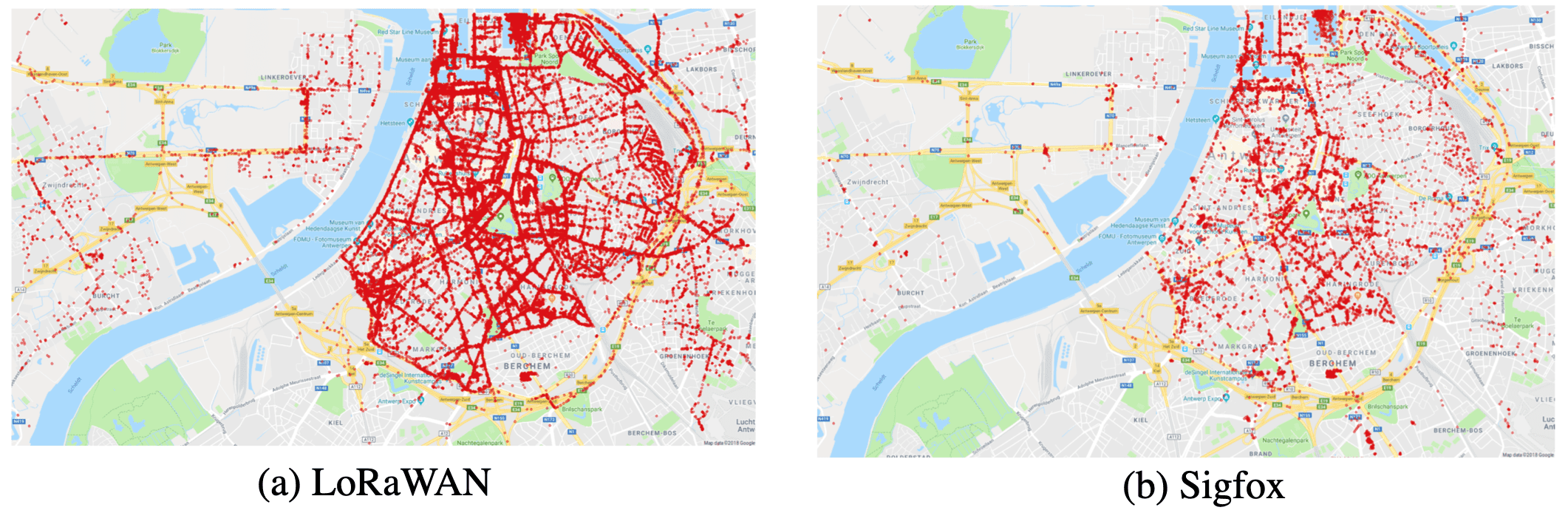
V-F Summary and Insight on Localization-Performance Evaluation Methods
The evaluation of localization performance is a tradeoff between performance and cost. For example, from the perspective of reflecting real localization scenarios, the order of the methods from the best to the worst is field testing, signal grafting, in-the-lab testing, simulation analysis, and theoretical analysis. In contrast, from the cost-effectivity perspective, the opposite order prevails. In LE-IoT applications, especially the low-cost ones, it is preferred to implement localization-performance evaluation through the methods in the order of theoretical analysis, simulation analysis, in-the-lab testing, signal grafting, and finally field testing.
An important factor for in-the-lab, signal-grafting, and field-testing methods is the acquirement of location references. When higher-accuracy external position-fixing techniques (e.g., GNSS Real-time kinematic, optical tracking, vision localization, UWB, ultrasonic, and RFID) are available, their positioning results can be used as location references. Otherwise, manually selected landmark points may be used for evaluating the localization solutions when the node has passed these points. Meanwhile, the constant-speed assumption [327] or short-term DR solutions [336] may be used to bridge the gap between landmark points. In this case, it is important to assure the accuracy of landmark positions and motion-assumption/DR solutions. Compared with the handheld and wearable modes, foot-mounted DR [365] provide significantly more robust location solutions. Thus, it is feasible to combine foot-mounted DR and external landmark and position-fixing data to generate location references.
VI Localization Opportunities From LPWAN and 5G
The newly-emerged LPWAN and 5G signals are bringing changes into the localization field. For example, they are expected to bring new technologies [52][359] such as smaller BSs, smarter devices, mmWave, MIMO, the support for D2D communications, and device-centric architectures. These new technologies may bring opportunities and changes to IoT localization.
VI-A Cooperative Localization
The research of cooperative localization mainly covers two topics. First, there are cooperative-localization methods that use the connection between multiple nodes and localization sensors on each node [360]. Meanwhile, there may be master nodes, which are equipped with higher-end sensors, and slave nodes, which have lower-end sensors [361]. The theoretical model and accuracy bounds of non-cooperative [362] and cooperative [362][363] localization systems have been researched. Meanwhile, the research in [364] provides theoretical and simulation analysis of vehicle cooperative localization through vehicle-to-vehicle and vehicle-to-infrastructure communications.
Meanwhile, there are cooperative-localization approaches that use multiple sets of nodes (e.g., smartphone, smart watch, and smart glasses) at various places on the human body [366]. The research in [367] has a detailed description on the soft and hard constraints as well as the state-constrained KF for localization using multiple devices on the same human body.
In the coming years, the characteristics of dense BSs and D2D communication capability may make it possible to provide accurate cooperative localization. The research in [359] has reviewed 5G cooperative localization and pointed out that cooperative localization can be an important feature for 5G networks.
VI-B Machine Learning / Artificial Intelligence
Subsection III-A3 has demonstrated the use of ML methods in IoT localization. Furthermore, the papers [368] and [369] have illustrated some challenges for using ML in sensor networks and location-based services. Examples of these challenges include how to improve ML effectiveness under localization scenario changes and how to collect, transfer, and store massive localization data. It is expected that ML will be more widely and deeply used in IoT localization applications due to factors such as the popularization of IoT BSs and nodes, the emergence of geo-spatial big data, and the further development of ML platforms and algorithms. How to combine the existing geometrical and DB-M localization methods with the state-of-the-art ML techniques will be a significant direction for IoT localization.
VI-C Multi-Sensor Integration
Multi-sensor integration is becoming a mainstream technique for enhanced IoT localization. Technologies such as LPWAN, 5G, GNSS, WiFi, and BLE can provide long-term location updates [99]. Meanwhile, inertial sensors and magnetometers can be used to provide attitude updates [370], which can be used for compensating for orientation diversity in IoT signals [178]. Moreover, it is possible to obtain a DR solution by fusing data from inertial sensors, odometers [371], air-flow sensors [372], and vision sensors [373]. Furthermore, to enhance localization performance, barometers [8] and Digital Terrain Models (DTMs) [374] can provide height or floor constraints, while road networks [375] and floor plans [376] can provide map constraints. Observability analysis [350] can be applied to indicate the unobservable or weakly-observable states in the localization system; then, it becomes possible to determine which types of sensors can be added to enhance localization.
VI-D Motion Constraints
For many low-cost IoT applications, it is not affordable to enhance localization through adding extra sensor hardware. Therefore, the use of motion constraints within the algorithm has a great potential. The typical constraints including vehicle kinematic constraints (e.g., NHC, ZUPT, and ZARU) [377], vehicle dynamic models (e.g., steering constraints [378], accelerating/braking constraints [379], multi-device constraints [367], aerodynamic forces [380], air-flow constraints [372], and path information [374]), and control inputs (e.g., [381]). It is also possible to evaluate the contribution of algorithm constraints through methods such as observability [350] and CRLB [340] analyses.
VI-E Airborne-Land Integrated Localization
With the development of small satellite and Low Earth Orbits (LEO) communication technologies, it has become possible to extend IoT-signal coverage by using LEOs [387]. The research in [388] introduces the optimization of LEO signals, while the paper [389] characterizes the performance of localization signals from LEOs.
Besides LEOs, enhancing localization signals from airborne platforms may also become a trend. For example, the research in [256] uses UAVs as BSs for IoT localization. There is great academic and industrial potential to integrate airborne- and land-based signals for enhanced IoT localization.
VI-F Multipath-Assisted Localization
Due to new features such as MIMO, dense miniaturized BS, and mmWave systems in 5G, using multipath signals to enhance localization, instead of reducing the multipath effect is attracting research interest. The research in [221] describes the principle and methodology for multipath-assisted localization, which has shown its potential to provide high-accuracy localization solutions.
VI-G Fog/Edge Computing
Fog and edge computing are being intensively researched in the IoT field. The papers [382] and [383] have described in detail the relation between IoT and fog/edge computing. However, the influence of fog/edge computing on localization has not been investigated. The research in [384] points out that there is a trend to use fog computing technology to achieve low-latency localization and location awareness solutions. On the other hand, an accurate IoT localization solution may contribute to the use of fog/edge computing. Therefore, the integration of IoT localization and fog/edge computing needs further investigation.
VI-H Blockchain
Blockchain is another newly-emerged technology that has gained wide attentions in numerous fields. The paper [385] has reviewed the relation between blockchain and IoT but has not involved IoT localization. For localization, the research in [386] presents a blockchain-based geofencing and localization strategy. In general, the combination of blockchain and IoT localization is still at an early stage and thus requires further investigation.
VII Conclusion
This paper reviews the IoT localization system through the sequence of IoT localization system review, localization data sources, localization algorithms, localization error sources and mitigation, localization performance evaluation, and new localization opportunities. Specifically,
Section II overviews the existing IoT technologies, followed by IoT localization applications, system architecture, and signal measurements.
Section III demonstrates the state-of-the-art IoT localization methods, including DB-M (e.g., deterministic, stochastic, and ML based DB-M) and geometrical (e.g., multilateration, hyperbolic positioning, multiangulation, and multiangulateration) localization.
Afterwards, Section IV systematically reviews IoT localization error sources and mitigation. The localization errors are divided into four parts: (1) end-device-based errors (e.g., device diversity, motion/attitude diversity, data loss/latency, and channel diversity), (2) propagation errors (e.g., multipath, NLoS, wide-area effects, multi-floor effects, human-body effects, weather effects, and signal variations), (3) base-station-based errors (e.g., number of BSs, BS geometry, BS location uncertainty, BS PLM-P uncertainty, and BS time synchronization errors), and (4) data-based errors (e.g., database timeliness/training cost, RP location uncertainty, database outage, data and computational loads, and localization integrity).
Then, Section V illustrates IoT localization performance evaluation methods, including theoretical analysis, simulation analysis, in-the-lab testing, signal grafting, and field testing.
Finally, Section VI shows the possible localization opportunities, such as cooperative localization, AI, multi-sensor integration, motion constraints, fog/edge computing, blockchain, airborne-land integration, and multipath-assisted localization.
In general, the emergence of LPWAN and 5G technologies have brought not only great advantages but also new challenges to localization applications. These technologies have attractive features such as long-range, low-power, and low-cost IoT signals, massive node connections, small and high-density BSs, the communication capacity. Therefore, it is definitely worthwhile to conduct further research on exploring localization functionality for future LE-IoT systems.
References
- [1] A. Zanella, N. Bui, A. Castellani, L. Vangelista and M. Zorzi, “Internet of Things for Smart Cities,” IEEE Internet Things J, vol. 1, no. 1, pp. 22-32, Feb. 2014.
- [2] F. Zafari, A. Gkelias and K. K. Leung, “A Survey of Indoor Localization Systems and Technologies,” IEEE Commun Surv Tut, doi: 10.1109/COMST.2019.2911558, Apr. 2019.
- [3] Z. Gao, Y. Li, Y. Zhuang, H. Yang, Y. Pan, H. Zhang, “Robust Kalman Filter Aided GEO/IGSO/GPS Raw-PPP/INS Tight Integration”. Sensors, vol. 2019, no. 19, pp. 1-17, Jan. 2019.
- [4] R. Shit, S. Sharma, D. Puthal and A. Zomaya, “Location of Things (LoT): A Review and Taxonomy of Sensors Localization in IoT Infrastructure,” IEEE Commun Surv Tut, vol. 20, no. 3, pp. 2028-2061, thirdquarter 2018.
- [5] M. Ramadan, V. Sark, J. Gutierrez and E. Grass, “NLoS Identification for Indoor Localization using Random Forest Algorithm,” in Int ITG Worksh Smart Ante, Bochum, Germany, 14-16 Mar. 2018.
- [6] P. Meissner, “Multipath-assisted Indoor Positioning”, Ph.D. Thesis, Graz University of Technology, Austria, Oct. 2014.
- [7] V. Erceg, L. Greenstein, S. Tjandra, R. Bianchi, et. al., “An empirically based path loss model for wireless channels in suburban environments,” IEEE J Sel Areas Commun, vol. 17, no. 7, pp. 1205-1211, Jul. 1999.
- [8] Y. Li, Z. Gao, Z. He, P. Zhang, R. Chen and N. El-Sheimy, “Multi-Sensor Multi-Floor 3D Localization With Robust Floor Detection,” IEEE Access, vol. 6, pp. 76689-76699, Nov. 2018.
- [9] J. Trogh, D. Plets, A. Thielens, L. Martens and W. Joseph, “Enhanced Indoor Location Tracking Through Body Shadowing Compensation,” IEEE Sens J, vol. 16, no. 7, pp. 2105-2114, Apr. 2016.
- [10] X. Niu, Y. Li, H. Zhang, Q. Wang, and Y. Ban, “Fast Thermal Calibration of Low-Grade Inertial Sensors and Inertial Measurement Units”, Sensors, vol. 13, no. 9, pp. 12192-12217, Sept. 2013.
- [11] Y. Li, Y. Zhuang, P. Zhang, H. Lan, X. Niu, and N. El-Sheimy, “An improved inertial/wifi/magnetic fusion structure for indoor navigation,” Inform Fusion, vol. 2017, no. 34, pp. 101-119, Mar. 2017.
- [12] S. Saeedi, “Context-Aware Personal Navigation Services Using Multi-level Sensor Fusion Algorithms”, Ph.D. Thesis, University of Calgary, Canada, Oct. 2013.
- [13] Y. Cheng, X. Wang, M. Morelande, and B. Moran, “Information geometry of target tracking sensor networks,” Inform Fusion, vol. 14, no. 3, pp. 311-326, Jul. 2013.
- [14] J. Torres-Solis, T. H. Falk, and T. Chau, “A review of indoor localization technologies: towards navigational assistance for topographical disorientation,” Ambient Intelligence, IntechOpen, London, UK, pp. 51-84, Mar. 2010.
- [15] J. Talvitie, M. Renfors and E. S. Lohan, “Distance-Based Interpolation and Extrapolation Methods for RSS-Based Localization With Indoor Wireless Signals,” IEEE T Veh Technol, vol. 64, no. 4, pp. 1340-1353, Apr. 2015.
- [16] Y. Li, Y. Zhuang, H. Lan, P. Zhang, X. Niu, and N. El-Sheimy, “Self-Contained Indoor Pedestrian Navigation Using Smartphone Sensors and Magnetic Features,” IEEE Sens J, vol. 16, no. 19, pp. 7173-7182, Oct. 2016.
- [17] A. Solin, M. Kok, N. Wahlström, T. B. Schön and S. Särkkä, “Modeling and Interpolation of the Ambient Magnetic Field by Gaussian Processes,” IEEE T Robot, vol. 34, no. 4, pp. 1112-1127, Aug. 2018.
- [18] N. Yu, X. Zhan, S. Zhao, Y. Wu, and R. Feng, “A Precise Dead Reckoning Algorithm Based on Bluetooth and Multiple Sensors,” IEEE Internet Things J, vol. 5, no. 1, pp. 336-351, Feb. 2018.
- [19] Y. Li, J. Georgy, X. Niu, Q. Li, and N. El-Sheimy, “Autonomous Calibration of MEMS Gyros in Consumer Portable Devices,” IEEE Sens J, vol. 15, no. 7, pp. 4062-72, Jul. 2015.
- [20] L. Pei, D. Liu, D. Zou, R. Choy, Y. Chen, and Z. He, “Optimal Heading Estimation Based Multidimensional Particle Filter for Pedestrian Indoor Positioning,” IEEE Access, vol. 6, pp. 49705-49720, Sept. 2018.
- [21] T. Lee, C. Kim and D. Cho, “A Monocular Vision Sensor-Based Efficient SLAM Method for Indoor Service Robots,” IEEE T Ind Elec, vol. 66, no. 1, pp. 318-328, Jan. 2019.
- [22] R. Mur-Artal, J. M. M. Montiel and J. D. Tardós, “ORB-SLAM: A Versatile and Accurate Monocular SLAM System,” IEEE T Robot, vol. 31, no. 5, pp. 1147-1163, Oct. 2015.
- [23] Y. Li, “Integration of MEMS Sensors, WiFi, and Magnetic Features for Indoor Pedestrian Navigation with Consumer Portable Devices”, Ph.D. Thesis, University of Calgary, Canada, Jan. 2016.
- [24] M. Wang, H. Qin, T. Jin, “Massive terminal positioning system with snapshot positioning technique”, GPS Solutions, vol. 23, no. 31, pp. 1-14, Apr. 2019.
- [25] T. Janssen, M. Weyn, R. Berkvens, “Localization in Low Power Wide Area Networks using Wi-Fi Fingerprints”, Applied Science, vol. 7, no. 936, pp. 1-16, Sept. 2017.
- [26] K. Mekki, E. Bajic, F. Chaxel, and F. Meyer, “A Comparative Study of LPWAN Technologies for Large-scale IoT Deployment”, ICT Express, vol. 5, no. 1, pp. 1-7, Mar. 2019.
- [27] N. Podevijn, D. Plets,J. Trogh, L. Martens, P. Suanet, K. Hendrikse, and W. Joseph, “TDoA-Based Outdoor Positioning with Tracking Algorithm in a Public LoRa Network”, Wirel Commun Mob Comput, vol. 2018, no. 1, pp. 1-9, May 2018.
- [28] Semtech, “LoRa Low Energy Consumption Design”, https://www.semtech.com/uploads/documents/LoraLowEnergyDesign_STD.pdf, Retrieved 21 Aug. 2019.
- [29] U. Raza, P. Kulkarni and M. Sooriyabandara, “Low Power Wide Area Networks: An Overview,” IEEE Commun Surv Tut, vol. 19, no. 2, pp. 855-873, Secondquarter 2017.
- [30] Y. Li, Z. He, Y. Li, H. Xu, L. Pei, and Y. Zhang, “Towards Location Enhanced IoT: Characterization of LoRa Signal For Wide Area Localization”, in Conf Ubiq Position In Nav Location Based Serv, Wuhan, China, 22-23 Mar. 2018.
- [31] S. Thielemans, M. Bezunartea and K. Steenhaut, “Establishing transparent IPv6 communication on LoRa based low power wide area networks (LPWANS),” in Wirel TeleCommun Sym, Chicago, IL, USA, pp. 1-6, 26-28 Apr. 2017.
- [32] J. Haxhibeqiri, E. Poorter, I. Moerman, and J. Hoebeke, “A Survey of LoRaWAN for IoT: From Technology to Application”, Sensors, vol. 18, no. 11, pp. 1-38, Nov. 2018.
- [33] J. Peral-Rosado, R. Raulefs, J. López-Salcedo, and G. Seco-Granados, “Survey of Cellular Mobile Radio Localization Methods: From 1G to 5G,” IEEE Commun Surv Tut, vol. 20, no. 2, pp. 1124-1148, Secondquarter 2018.
- [34] COST Action CA15104, “Whitepaper on New Localization Methods for 5G Wireless Systems and the Internet-of-Things”, http://www.iracon.org/wp-content/uploads/2018/03/IRACON-WP2.pdf, Retrieved 21 Aug. 2019.
- [35] A. Ikpehai, B. Adebisi, K. Rabie, K. Anoh, R. Ande, M. Hammoudeh, H. Gacanin, and U. Mbanaso, “Low-Power Wide Area Network Technologies for Internet-of-Things: A Comparative Review,” IEEE Internet Things J, vol. 6, no. 2, pp. 2225-2240, Apr. 2019.
- [36] Y. Zhuang, L. Hua, L. Qi, J. Yang, P. Cao, Y. Cao, Y. Wu, J. Thompson and H. Haas, ”A Survey of Positioning Systems Using Visible LED Lights,” IEEE Commun Surv Tut, vol. 20, no. 3, pp. 1963-1988, thirdquarter 2018.
- [37] J. Petäjäjärvi, K. Mikhaylov, M. Pettissalo, J. Janhunen, and J. Iinatti, “Performance of a Low-Power Wide-Area Network based on LoRa Technology: Doppler Robustness, Scalability, and Coverage”, Int J Dist Sens Net, vol. 13, no. 3, pp. 1-16, Feb. 2017.
- [38] I. De Almeida, L. Mendes, J. Rodrigues and M. Da Cruz, “5G Waveforms for IoT Applications,” IEEE Commun Surv Tut, vol. 21, no. 3, pp. 2554-2567, thirdquarter 2019.
- [39] Actility, “Whitepaper - LoraWAN and Cellular IoT (NB-IoT, LTE-M): How do they complement each other”, https://www.slideshare.net/Actility/whitepaper-lorawan-and-cellular-iot-nbiot-ltem-how-do-they-complement-each-other, Retrieved 21 Aug. 2019.
- [40] M. Rewers,“5G-IoT-LPWAN: What is the Relationship?”, https://www.linkedin.com/pulse/5g-iot-lpwan-what-relationship-mark-rewers/, Retrieved 21 Aug. 2019.
- [41] F. Wen, H Wymeersch, B. Peng, W. Tay, H. So, and D. Yang, “A Survey on 5G Massive MIMO Localization”, Digital Signal Proces, in press, pp. 1-8, May 2019.
- [42] LoRa Alliance,“LoRaWAN”, https://lora-alliance.org/, Retrieved 21 Aug. 2019.
- [43] Sigfox,“Sigfox”, https://www.sigfox.com/en, Retrieved 21 Aug. 2019.
- [44] 3GPP,“3GPP Release-13”, https://www.3gpp.org/release-13, Retrieved 21 Aug. 2019.
- [45] WiFi Alliance, “WiFi HaLow”, https://www.wi-fi.org/discover-wi-fi/wi-fi-halow, Retrieved 21 Aug. 2019.
- [46] Weightless, “Weightless Specification”, http://www.weightless.org/about/weightless-specification, Retrieved 21 Aug. 2019.
- [47] Ingenu, “RPMA Technology”, https://www.ingenu.com/technology/rpma/, Retrieved 21 Aug. 2019.
- [48] Telensa, “Telensa: Making Brighter Cities”, https://www.ingenu.com/technology/rpma/, Retrieved 21 Aug. 2019.
- [49] Qowisio, “Qowisio, IoT Project Accelerator”, https://www.qowisio.com/en/qowisio-english/, Retrieved 21 Aug. 2019.
- [50] Global mobile Suppliers Association, “Global Narrowband IoT - LTE-M networks - March 2019”, https://gsacom.com/paper/global-narrowband-iot-lte-m-networks-march-2019/, Retrieved 21 Aug. 2019.
- [51] J. Restrepo, “World Radio 5G Roadmap: Challenges and Opportunities Ahead”, https://www.itu.int/en/ITU-R/seminars/rrs/RRS-17-Americas/Documents/Forum/1_ITU%20Joaquin%20Restrepo.pdf, Retrieved 21 Aug. 2019.
- [52] J. Andrews, S. Buzzi, W. Choi, S. Hanly, A. Lozano, A. Soong, and J. Zhang, ”What Will 5G Be?,” IEEE J Sel Areas Commun, vol. 32, no. 6, pp. 1065-1082, Jun. 2014.
- [53] Federal Communications Commission, “FCC 15-9”, https://ecfsapi.fcc.gov/file/60001025925.pdf, Retrieved 21 Aug. 2019.
- [54] I. Chochliouros, A. Spiliopoulou-Chochliourou and G. Lalopoulos, “Emergency call (eCall) services based on approved E-112 regulations and infrastructures”, J Commun Networks, vol. 4, no. 3, pp. 76-84, Apr. 2005.
- [55] Y. Mehmood, F. Ahmad, I. Yaqoob, A. Adnane, M. Imran and S. Guizani, “Internet-of-Things-Based Smart Cities: Recent Advances and Challenges,” IEEE Commun Mag, vol. 55, no. 9, pp. 16-24, Sept. 2017.
- [56] P. Guan, Z. Zhang, L. Wei and Y. Zhao, “A Real-Time Bus Positioning System Based on LoRa Technology,” in Int Conf Smart Grid Smart Cities, Kuala Lumpur, pp. 45-48, 12-14 Aug. 2018.
- [57] W. Da Silva, L. Oliveira, N. Kumar, R. Rabêlo, C. Marins, and J. Rodrigues, “An Internet of Things Tracking System Approach Based on LoRa Protocol,” in IEEE Global Commun Conf, Abu Dhabi, United Arab Emirates, pp. 1-7, 9-13 Dec. 2018.
- [58] A. Nugraha, R. Wibowo, M. Suryanegara, and N. Hayati, “An IoT-LoRa System for Tracking a Patient with a Mental Disorder: Correlation between Battery Capacity and Speed of Movement,” in Int Conf Comput Commu Engineer, Kuala Lumpur, pp. 198-201, 19-20 Sept. 2018.
- [59] S. Leugner, M. Pelka and H. Hellbrück, “Comparison of wired and wireless synchronization with clock drift compensation suited for U-TDoA localization,” in Worksh Position Nav Commun, Bremen, pp. 1-4, 19-20 Oct. 2016.
- [60] A. Badawy, T. Khattab, D. Trinchero, T. Elfouly and A. Mohamed, “A Simple AoA Estimation Scheme”, CoRR, vol. abs/1409.5744, pp. 1-7, Sept. 2014.
- [61] H. Sallouha, A. Chiumento and S. Pollin, “Localization in long-range ultra narrow band IoT networks using RSSI,” in IEEE Int Conf Commun, Paris, pp. 1-6, 21-25 May 2017.
- [62] M. Bor, U. Roedig, T. Voigt, and J. Alonso, “Do LoRa Low-Power Wide-Area Networks Scale?”, in ACM Int Conf on Modeling, Analysis and Simulation of Wirel and Mobile Systems, Malta, Malta, 13-17 Nov. 2016.
- [63] S. Seidel and T. Rappaport, “914 MHz path loss prediction models for indoor wireless communications in multifloored buildings,” IEEE T Ant Propag, vol. 40, no. 2, pp. 207-217, Feb. 1992.
- [64] D. Dardari, A. Conti, U. Ferner, A. Giorgetti, and M. Win, “Ranging With Ultrawide Bandwidth Signals in Multipath Environments,” Proc IEEE, vol. 97, no. 2, pp. 404-426, Feb. 2009.
- [65] Marvelmind, “Marvelmind Indoor Navigation System Operating manual”, https://marvelmind.com/pics/marvelmind_navigation_system_manual.pdf, Retrieved 21 Aug. 2019.
- [66] J. Shen, A. F. Molisch and J. Salmi, “Accurate Passive Location Estimation Using TOA Measurements,” IEEE T Wirel Commun, vol. 11, no. 6, pp. 2182-2192, Jun. 2012.
- [67] R. Kaune, J. Hörst and W. Koch, “Accuracy analysis for TDOA localization in sensor networks,” in Int Conf Inform Fusion, Chicago, IL, 2011, pp. 1-8, 5-8 Jul. 2011.
- [68] L. Bai, C. Peng and S. Biswas, “Association of DOA Estimation From Two ULAs,” IEEE T Inst Meas, vol. 57, no. 6, pp. 1094-1101, Jun. 2008.
- [69] Quuppa, “Product and Technology”, http://quuppa.com/technology/, Retrieved 01 Oct. 2018.
- [70] Y. Wang and K. Ho, “An Asymptotically Efficient Estimator in Closed-Form for 3-D AOA Localization Using a Sensor Network,” IEEE T Wirel Commun, vol. 14, no. 12, pp. 6524-6535, Dec. 2015.
- [71] Y. Li, K. Yan, Z. He, Y. Li, Z. Gao, L. Pei, R. Chen, and N. El-Sheimy, “Cost-Effective Localization Using RSS from Single Wireless Access Point,” IEEE T Inst Meas, doi: 10.1109/TIM.2019.2922752, Jun. 2019.
- [72] M. Ciurana, F. Barcelo-Arroyo and F. Izquierdo, “A ranging system with IEEE 802.11 data frames,” in IEEE Radio and Wirel Sym, Long Beach, CA, pp. 133-136, 9-11 Jan. 2007.
- [73] A. Günther and C. Hoene, “Measuring Round Trip Times to Determine the Distance Between WLAN Nodes”, Lect Note Comput Sci, vol. 3462, no. 1, pp. 768-779, May. 2005.
- [74] D. Halperin, W. Hu, A. Sheth, and D. Wetherall, “Tool Release: Gathering 802.11n Traces with Channel State Information”, ACM SIGCOMM Computer Commu Review, vol. 41, no. 1, Jan. 2011.
- [75] K. Wu, J. Xiao, Y. Yi, D. Chen, X. Luo, and L. Ni, “CSI-Based Indoor Localization,” IEEE T Parallel Dist Sys, vol. 24, no. 7, pp. 1300-1309, Jul. 2013.
- [76] R. Chen and F. Ye, “An Overview of Indoor Positioning Technology Based on Wi-Fi Channel State Information”, Geomatics Inform Sci Wuhan Univ, vol. 43, no. 12, pp. 2064-2070, May 2018.
- [77] D. Vasisht, S. Kumar, and D. Katabi, “Decimeter-Level Localization with a Single WiFi Access Point,” in Proc Sym Net Sys Design Implem, vol. 1, no. 1, pp. 1-14, Santa Clara, CA, 16-18 Mar. 2016.
- [78] C. Gu, L. Jiang, R. Tan, “LoRa-Based Localization: Opportunities and Challenges”, in Worksh Low Power Wide Area Net Internet Thing, Sentosa, Singapore, 11-13 Dec. 2018.
- [79] M. Scherhäufl, M. Pichler, D. Müller, A. Ziroff and A. Stelzer, “Phase-of-arrival-based localization of passive UHF RFID tags,” in IEEE MTT-S Int Microwave Sym Digest, Seattle, WA, pp. 1-3, 2-7 Jun. 2013.
- [80] J. Geng, X. Meng, A. Dodson, M. Ge, and F. Teferle, “Rapid re-convergences to ambiguity-fixed solutions in precise point positioning”, J Geodesy, vol. 84, no. 12, pp. 705-714, Dec. 2010.
- [81] W. Jiang, Y. Li, C. Rizos, B. Cai, and W. Shangguan, “Seamless Indoor-Outdoor Navigation based on GNSS, INS and Terrestrial Ranging Techniques”, J Nav, vol. 70, no. 6, pp. 1183-1204, Nov. 2017.
- [82] E. Kazikli and S. Gezici, “Hybrid TDOA/RSS based localization for visible light systems”, Digital Signal Proces, vol. 86, no. 1, pp. 19-28, Mar. 2019.
- [83] J. Yin, Q. Wan, S. Yang and K. C. Ho, “A Simple and Accurate TDOA-AOA Localization Method Using Two Stations,” IEEE Signal Proces Le, vol. 23, no. 1, pp. 144-148, Jan. 2016.
- [84] C. Figuera, J. L. Rojo-Alvarez, I. Mora-Jimenez, A. Guerrero-Curieses, M. Wilby, and J. Ramos-Lopez, “Time-Space Sampling and Mobile Device Calibration for WiFi Indoor Location Systems,” IEEE T Mob Comput, vol. 10, no. 7, pp. 913-926, Jul. 2011.
- [85] P. Maybeck, “Stochastic Models, Estimation, and Control”, Academic Press, New York, 1982.
- [86] C. Luo, P. Casaseca-de-la-Higuera, S. McClean, G. Parr and P. Ren, ”Characterization of Received Signal Strength Perturbations Using Allan Variance,” IEEE T Aero Elec Sys, vol. 54, no. 2, pp. 873-889, Apr. 2018.
- [87] A. Radi, G. Bakalli, S. Guerrier, N. El-Sheimy, A. B. Sesay and R. Molinari, ”A Multisignal Wavelet Variance-Based Framework for Inertial Sensor Stochastic Error Modeling,” IEEE T Inst Meas, doi: 10.1109/TIM.2019.2899535, pp. 1-13, Mar. 2019.
- [88] H. Lim, L. Kung, J. Hou and H. Luo, “Zero-Configuration, Robust Indoor Localization: Theory and Experimentation,” Proc IEEE Int Conf Comput Commun, Barcelona, pp. 1-12, 23-29 Apr. 2006.
- [89] A. Haeberlen, E. Flannery, A. M. Ladd, A. Rudys, D. S. Wallach, and L. E. Kavraki, “Practical robust localization over large-scale 802.11 wireless networks,” in Proc annu Int Conf Mob comput net, pp. 70-84, Philadelphia, PA, 26 Sept. - 01 Oct. 2004.
- [90] C. Laoudias, R. Piche, and C. Panayiotou, “Device self-calibration in location systems using signal strength histograms”, J Location Based Services, vol. 7, no. 3, pp. 165-181, May 2013.
- [91] Y. Li, Z. Gao, Z. He, Y. Zhuang, A. Radi, R. Chen, N. El-Sheimy, “Wireless Fingerprinting Uncertainty Prediction Based on Machine Learning.” Sensors, vol. 19, no. 2, Jan. 2019.
- [92] X. Guo, N. Ansari, L. Li and H. Li, “Indoor Localization by Fusing a Group of Fingerprints Based on Random Forests,” IEEE Internet Things J, doi: 10.1109/JIOT.2018.2810601, Feb. 2018.
- [93] Z. He, Y. Li, L. Pei and K. O’Keefe, “Enhanced Gaussian Process-Based Localization using a Low Power Wide Area Network,” IEEE Commun Le, doi: 10.1109/LCOMM.2018.2878704, Oct. 2018.
- [94] B. Peng, G. Seco-Granados, E. Steinmetz, M. Fröhle and H. Wymeersch, “Decentralized Scheduling for Cooperative Localization With Deep Reinforcement Learning,” IEEE T Veh Technol, vol. 68, no. 5, pp. 4295-4305, May 2019.
- [95] J. Niu, B. Wang, L. Shu, T. Q. Duong and Y. Chen, “ZIL: An Energy-Efficient Indoor Localization System Using ZigBee Radio to Detect WiFi Fingerprints,” IEEE J Sel Areas Commun, vol. 33, no. 7, pp. 1431-1442, Jul. 2015.
- [96] J. Torres-Sospedra, R. Montoliu, S. Trilles, Ó. Belmonte, and J. Huerta, “Comprehensive analysis of distance and similarity measures for Wi-Fi fingerprinting indoor positioning systems,” Expert Sys Appl, vol. 42, no. 23, pp. 9263-9278, Dec. 2015.
- [97] Y. Xie, Y. Wang, A. Nallanathan and L. Wang, ”An Improved K-Nearest-Neighbor Indoor Localization Method Based on Spearman Distance,” IEEE Signal Proces Le, vol. 23, no. 3, pp. 351-355, Mar. 2016.
- [98] K. Kaemarungsia and P. Krishnamurthy, “Analysis of WLAN’s received signal strength indication for indoor location fingerprinting”, Pervasive Mob Comput, vol. 8, no. 2, pp. 292-316, Apr. 2012.
- [99] Y. Li, Z. He, Z. Gao, Y. Zhuang, C. Shi and N. El-Sheimy, “Toward Robust Crowdsourcing-Based Localization: A Fingerprinting Accuracy Indicator Enhanced Wireless/Magnetic/Inertial Integration Approach,” IEEE Internet Things J, vol. 6, no. 2, pp. 3585-3600, Apr. 2019.
- [100] K. Gurney, “An Introduction to Neural Networks”, CRC Press, London, 1997.
- [101] J. Choi, W. Lee, J. Lee, J. Lee and S. Kim, “Deep Learning Based NLoS Identification With Commodity WLAN Devices,” IEEE T Veh Technol, vol. 67, no. 4, pp. 3295-3303, Apr. 2018.
- [102] D. Konings, B. Parr, F. Alam and E. Lai, “Falcon: Fused Application of Light Based Positioning Coupled With Onboard Network Localization,” IEEE Access, vol. 6, pp. 36155-36167, 2018.
- [103] Z. Li, G. He, M. Li, L. Ma, Q. Chen, J. Huang, J. Cao, S. Feng, H. Gao and S. Wang, “RBF neural network based RFID indoor localization method using artificial immune system,” in Chinese Control Decision Conf, Shenyang, pp. 2837-2842, 9-11 Jun. 2018.
- [104] A. Abdallah, S. Saab and Z. Kassas, “A machine learning approach for localization in cellular environments,” in IEEE/ION Position Location Nav Sym, Monterey, CA, pp. 1223-1227, 23-26 Apr. 2018.
- [105] I. Goodfellow, Y. Bengio, and A. Courville, “Deep Learning”, MIT Press, 2016.
- [106] M. T. Hagan and M. B. Menhaj, “Training feedforward networks with the Marquardt algorithm,” IEEE T Neural Net, vol. 5, no. 6, pp. 989-993, Nov. 1994.
- [107] K. Chiang, A. Noureldin and N. El-Sheimy, “A new weight updating method for INS/GPS integration architectures based on neural networks”, Meas Sci Tech, vol. 15, no. 10, pp. 2053-2061, 2004.
- [108] B. Akram, A. Akbar and O. Shafiq, “HybLoc: Hybrid Indoor Wi-Fi Localization Using Soft Clustering-Based Random Decision Forest Ensembles,” IEEE Access, vol. 6, pp. 38251-38272, 2018.
- [109] J. Li, Y. Wei, M. Wang, J. Luo and Y. Hu, “Two indoor location algorithms based on sparse fingerprint library,” in Chinese Control Decision Conf, Shenyang, pp. 6753-6758, 9-11 Jun. 2018.
- [110] S. Gharghan, R. Nordin, A. Jawad, H. Jawad and M. Ismail, “Adaptive Neural Fuzzy Inference System for Accurate Localization of Wireless Sensor Network in Outdoor and Indoor Cycling Applications,” IEEE Access, vol. 6, pp. 38475-38489, 2018.
- [111] E. L. Berz, D. A. Tesch and F. P. Hessel, “Machine-learning-based system for multi-sensor 3D localisation of stationary objects,” IET Cyber-Physical Sys Theory & Appl, vol. 3, no. 2, pp. 81-88, 2018.
- [112] J. Jang and S. Hong, “Indoor Localization with WiFi Fingerprinting Using Convolutional Neural Network,” in Int Conf Ubiq Future Net, Prague, pp. 753-758, 2018.
- [113] R. Elbakly, H. Aly and M. Youssef, “TrueStory: Accurate and Robust RF-Based Floor Estimation for Challenging Indoor Environments,” IEEE Sens J, vol. 18, no. 24, pp. 10115-10124, Dec. 2018.
- [114] X. Wang, X. Wang and S. Mao, “Deep Convolutional Neural Networks for Indoor Localization with CSI Images,” IEEE T Network Sci Engineering, doi: 10.1109/TNSE.2018.2871165, Sept. 2018.
- [115] X. Zhang, H. Sun, S. Wang and J. Xu, “A New Regional Localization Method for Indoor Sound Source Based on Convolutional Neural Networks,” IEEE Access, vol. 6, pp. 72073-72082, 2018.
- [116] B. Dong, T. Burgess, H. Neuner and S. Fercher, “Neural Network Based Radio Fingerprint Similarity Measure,” in Int Conf In Position In Nav, Nantes, France, pp. 1-8, 2018.
- [117] N. Akail, L. Y. Moralesl and H. Murase, “Reliability Estimation of Vehicle Localization Result,” in IEEE Intell Veh Sym, Changshu, pp. 740-747, 2018.
- [118] Alex Graves A. Mohamed and G. Hinton, “Speech Recognition with Deep Recurrent Neural Networks”, in IEEE Int Conf Acoustics Speech Signal Proces, Vancouver, Canada, 26-31, May 2013.
- [119] K. Gregor, I. Danihelka, A. Graves, D. Rezende, D. Wierstra, “DRAW: A Recurrent Neural Network For Image Generation”, Proc Int Conf Mach Learn, Lille, France, 2015.
- [120] C. Rasmussen and C. Williams, “Gaussian Processes for Machine Learning”, MIT Press, Cambridge, MA, 2006.
- [121] Y. Li, Z. He, Y. Zhuang, Z. Gao, G. Tsai, and L. Pei, “Robust Localization through Integration of Crowdsourcing and Machine Learning”, in Int Conf Mob Map Tech, Shenzhen, China, 6-8, May 2019.
- [122] S. Anton, M. Grigoras, V. Tresp and C. Hoffmann, “GPPS: A Gaussian Process Positioning System for Cellular Networks”, Adv Neural Inform Proces Sys, MIT Pres, Cambridge, MA, pp. 579-586, 2004.
- [123] B. Ferris, D. Hähnel and D. Fox. “Gaussian Processes for Signal Strength-Based Location Estimation”, in Robot Sci Sys, Philadelphia, PA, USA, 16-19, Aug. 2006.
- [124] F. Seco, C. Plagemann, A. R. Jiménez and W. Burgard, ”Improving RFID-based indoor positioning accuracy using Gaussian processes,” in Int Conf In Position In Nav, Zurich, pp. 1-8, 15-17 Sept. 2010.
- [125] W. Choi, Y. Chang, Y. Jung and J. Song, “Low-Power LoRa Signal-Based Outdoor Positioning Using Fingerprint Algorithm”, ISPRS J Geo-Inf, vol. 7, no. 11, pp. 1-15, Nov. 2018.
- [126] F. Pedregosa, G. Varoquaux, A. Gramfort, V. Michel, B. Thirion, et al., “Scikit-learn: Machine Learning in Python”, J Mach Learn Res, vol. 12, no. 1, pp.2825-2830, Oct. 2011.
- [127] J. Rodriguez, L. Kuncheva and C. Alonso, “Rotation Forest: A New Classifier Ensemble Method,” IEEE T Pattern Anal Mach Intell, vol. 28, no. 10, pp. 1619-1630, Oct. 2006.
- [128] B. Menze, M. Kelm, R. Masuch, U. Himmelreich, P. Bachert, W. Petrich and F. Hamprecht, “A comparison of random forest and its Gini importance with standard chemometric methods for the feature selection and classification of spectral data”, BMC Bioinform, vol. 10, no. 213, pp. 1-16, Jul. 2009.
- [129] J. Quinlan, “Induction of Decision Trees”, Machine Learning, vol. 1, no. 1, pp. 81-106, Mar. 1986.
- [130] D. Massiceti, A. Krull, E. Brachmann, C. Rother and P. Torr, “Random Forests versus Neural Networks - What’s Best for Camera Localization?”, in IEEE Int Conf Robot Auto, Marina Bay Sands, Singapore, May 29 - Jun 3, 2017.
- [131] J. Kua, N. Corso and A. Zakhor, “Automatic loop closure detection using multiple cameras for 3D indoor localization”, in Proc Int Society Optic Engineering, California, USA, 10 Feb. 2012.
- [132] Y. Wang, C. Xiu, C. Zhang, D. Yang, “WiFi Indoor Localization with CSI Fingerprinting-Based Random Forest”, Sensors, vol. 18, no. 9, pp. 1-23, Aug. 2018.
- [133] X. Guo, S. Shao, N. Ansari and A. Khreishah, “Indoor Localization Using Visible Light Via Fusion of Multiple Classifiers,” IEEE Photonics J, vol. 9, no. 6, pp. 1-16, Dec. 2017.
- [134] N. Horning, “Introduction to decision trees and random forests”, http://whrc.org/wp-content/uploads/2016/02/Horning_DecisionTrees_RandomForest.pdf, Retrieved 21 Aug. 2019.
- [135] G. Briem, J. Benediktsson and J. Sveinsson, “Multiple classifiers applied to multisource remote sensing data,” IEEE T Geoscience Remote S, vol. 40, no. 10, pp. 2291-2299, Oct. 2002.
- [136] M. Hessel, J. Modayil, H. Hasselt, T. Schaul, G. Ostrovski, W. Dabney, D. Horgan, B. Piot, M. Azar, D. Silver, “Rainbow: Combining Improvements in Deep Reinforcement Learning”, in AAAI Conf Artif Intell, New Orleans, USA, 2-7 Feb. 2018.
- [137] V. Mnih, K. Kavukcuoglu, D. Silver, A. Rusu, D. Hassabis, et. al, “Human-level control through deep reinforcement learning”, Nature, vol. 518, no. 1, pp. 529-533, Feb. 2015.
- [138] V. Mnih, A. Badia1, M. Mirza, A. Graves, K. Kavukcuoglu, et. al., “Asynchronous Methods for Deep Reinforcement Learning”, Proc Int Conf Mach Learn New York, NY, USA, 19-24, Jun. 2016.
- [139] X. Hu, S. Liu, R. Chen, W. Wang and C. Wang, “A Deep Reinforcement Learning-Based Framework for Dynamic Resource Allocation in Multibeam Satellite Systems,” IEEE Commun Le, vol. 22, no. 8, pp. 1612-1615, Aug. 2018.
- [140] V. Dhiman, S. Banerjee, B. Griffin, J. Siskind, J. Corso, “A Critical Investigation of Deep Reinforcement Learning for Navigation”, ArXiv, arXiv:1802.02274v2, Jan. 2019.
- [141] J. Zhang, J. Springenberg, J. Boedecker, W. Burgard, “Deep reinforcement learning with successor features for navigation across similar environments,” IEEE/RSJ Int Conf Intell Robot Sys, Vancouver, BC, Canada, pp. 2371-2378, 24-28 Sept. 2017.
- [142] J. Bruce, N. Sünderhauf,P. Mirowski, R. Hadsell, M. Milford, “One-Shot Reinforcement Learning for Robot Navigation with Interactive Replay”, in Conf Neural Inform Proces Sys, Long Beach, CA, USA, 4-9 Dec. 2017.
- [143] L. Tai, G. Paolo and M. Liu, “Virtual-to-real deep reinforcement learning: Continuous control of mobile robots for mapless navigation,” in IEEE/RSJ Int Conf Intell Robot Sys, Vancouver, BC, Canada, pp. 2371-2378, 24-28 Sept. 2017.
- [144] E. Bejar and A. Moran, “Deep reinforcement learning based neuro-control for a two-dimensional magnetic positioning system,” Int Conf Control Auto Robot, Auckland, pp. 268-273, 20-23 Apr. 2018.
- [145] M. Mohammadi, A. Al-Fuqaha, M. Guizani and J. Oh, “Semisupervised Deep Reinforcement Learning in Support of IoT and Smart City Services,” IEEE Internet Things J, vol. 5, no. 2, pp. 624-635, Apr. 2018.
- [146] P. Mirowski, M. Grimes, M. Malinowski, et al., “Learning to Navigate in Cities Without a Map”, ArXiv, arXiv:1804.00168, Mar. 2018.
- [147] O. Zhelo, J. Zhang, L. Tai, M. Liu, W. Burgard, “Curiosity-driven Exploration for Mapless Navigation with Deep Reinforcement Learning”, ArXiv, arXiv:1804.00456, May 2018.
- [148] Y. Zhu, R. Mottaghi, E. Kolve, et al., “Target-driven visual navigation in indoor scenes using deep reinforcement learning,” in IEEE Int Conf Robot Auto, Singapore, 2017, pp. 3357-3364, 29 May-3 Jun. 2017.
- [149] J. Scholz, “Deep Reinforcement Learning Tutorial”, http://www.robot-manipulation.uk/jon_scholz_deep_reinforcement_learning_tutorial.pdf, Retrieved 21 Aug. 2019.
- [150] S. Sun, Y. Li, W. S. T. Rowe, X. Wang, A. Kealy and B. Moran, “Practical evaluation of a crowdsourcing indoor localization system using hidden Markov models,” IEEE Sens J, doi: 10.1109/JSEN.2019.2925457, Jun. 2019.
- [151] A. Jitta and A. Klami, “Partially hidden Markov models for privacy-preserving modeling of indoor trajectories”,Neurocomputing, vol. 266, no. 1, pp. 196-205, Nov. 2017.
- [152] J. Carrera, Z. Zhao and T. Braun, “Room Recognition Using Discriminative Ensemble Learning with Hidden Markov Models for Smartphones”, in IEEE Annu Int Sym Personal In Mob Radio Commun, Bologna, Italy, 9-12, Sept. 2018.
- [153] T. Sanam and H. Godrich, “An Improved CSI Based Device Free Indoor Localization Using Machine Learning Based Classification Approach,” Europ Signal Proces Conf, Rome, Italy, pp. 2390-2394, 3-7, Sept. 2018.
- [154] H. Ahmadi and R. Bouallegue, “Exploiting machine learning strategies and RSSI for localization in wireless sensor networks: A survey,” in Int Wirel Commun Mob Comput Conf, Valencia, pp. 1150-1154, 26-30 Jun. 2017.
- [155] R. Timoteo, L. Silva, D. Cunha, G. Cavalcanti, “An approach using support vector regression for mobile location in cellular networks”, Comput Network, vol. 95, no. 1, pp. 51-61, Feb. 2016.
- [156] F. Orujov, R. Maskeliūnas, R. Damaševičius, W. Wei, Y. Li, “Smartphone based intelligent indoor positioning using fuzzy logic”, Future Generation Computer Sys, vol. 89, no. 1, pp. 335-348, Dec. 2018.
- [157] G. Pau, M. Collotta, V. Maniscalco, K. Choo, “A fuzzy-PSO system for indoor localization based on visible light communications”, Soft Comput, vol. 23, no. 14, pp. 5547-5557, Jul. 2019.
- [158] I. Guvenc and C. Chong, “A Survey on TOA Based Wireless Localization and NLoS Mitigation Techniques,” IEEE Commun Surv Tut, vol. 11, no. 3, pp. 107-124, 3rd Quarter 2009.
- [159] Y. Cheng, Y. Chawathe, A. LaMarca and J. Krumm, “Accuracy Characterization for Metropolitan-scale Wi-Fi Localization”, in Proc Int Conf Mob Sys Appl Services, pp. 233-245, Seattle, USA, June 6-8, 2005.
- [160] D. Plets, W. Joseph, K. Vanhecke, E. Tanghe, L. Martens, “Coverage prediction and optimization algorithms for indoor environments”, EURASIP J Wirel Commun Net, vol. 2012, no. 123, pp. 1-23, Mar. 2012.
- [161] M. Petovello, “Real-Time Integration of a Tactical-Grade IMU and GPS for High-Accuracy Positioning and Navigation”, Ph.D. Thesis, University of Calgary, Canada, Apr. 2003.
- [162] Y. Zhuang, J. Yang, L. Qi, Y. Li, Y. Cao and N. El-Sheimy, “A Pervasive Integration Platform of Low-Cost MEMS Sensors and Wireless Signals for Indoor Localization,” IEEE Internet Things J, doi: 10.1109/JIOT.2017.2785338, Dec. 2017.
- [163] R. Langley, “Dilution of precision”, GPS world, May 1999.
- [164] B. Zhou, Q. Chen and P. Xiao, “The Error Propagation Analysis of the Received Signal Strength-Based Simultaneous Localization and Tracking in Wireless Sensor Networks,” IEEE T Inform Theory, vol. 63, no. 6, pp. 3983-4007, Jun. 2017.
- [165] G. Hefley, “The Development of Loran-C Navigation and Timing”, NBS Monograph 129, Boulder, CO: U.S. National Bureau of Standards, 1972.
- [166] D. Niculescu and Badri Nath, “Ad hoc positioning system (APS) using AOA,” Annu Joint Conf IEEE Comput Commun Societies, San Francisco, CA, pp. 1734-1743, 30 Mar.-3 Apr. 2003.
- [167] W. Schofield, “Engineering Surveying: Theory and Examination Problems for Students”, Butterworth-Heinemann, 2001.
- [168] H. Will, T. Hillebrandt, Y. Yuan, Z. Yubin and M. Kyas, “The Membership Degree Min-Max localization algorithm,” in Ubiq Position In Nav Location Based Service, Helsinki, pp. 1-10., 3-4 Oct. 2012.
- [169] A. Savvidesm, H. Park, M. Srivastava, “The bits and flops of the N-hop multilateration primitive for node localization problems”, in ACM Int Worksh Wirel Sens Net Appl, Atlanta, Georgia, USA, 28, Sept. 2002.
- [170] P. Pivato, L. Palopoli and D. Petri, “Accuracy of RSS-Based Centroid Localization Algorithms in an Indoor Environment,” IEEE T Inst Meas, vol. 60, no. 10, pp. 3451-3460, Oct. 2011.
- [171] M. Bouet and A. Santos, “RFID tags: Positioning principles and localization techniques,” in IFIP Wirel Days, Dubai, United Arab Emirates, pp. 1-5, 24-27 Nov. 2008.
- [172] M. Bshara, U. Orguner, F. Gustafsson and L. Van Biesen, “Robust Tracking in Cellular Networks Using HMM Filters and Cell-ID Measurements,” IEEE T Veh Technol, vol. 60, no. 3, pp. 1016-1024, Mar. 2011.
- [173] Y. Wu, Y. Chen and S. Sheu, “Indoor location estimation using virtual fingerprint construction and zone-based remedy algorithm,” in Int Conf Commu Prob Solv, Taipei, China, pp. 1-3, 7-9 Sept. 2016.
- [174] F. Kirsch, M. Gottinger, Y. Dobrev and M. Vossiek, “Advanced Wireless Local Positioning via Compressed Sensing,” IEEE Access, vol. 6, pp. 25110-25120, Apr. 2018.
- [175] A. Lagias, T. Lagkas and J. Zhang, “New RSSI-Based Tracking for Following Mobile Targets Using the Law of Cosines,” IEEE Wirel Commun Le, vol. 7, no. 3, pp. 392-395, Jun. 2018.
- [176] J. Zhang, G. Han, N. Sun and L. Shu, “Path-Loss-Based Fingerprint Localization Approach for Location-Based Services in Indoor Environments,” IEEE Access, vol. 5, no. 1, pp. 13756-13769, Jul. 2017.
- [177] N. Kodippili and D. Dias, “Integration of fingerprinting and trilateration techniques for improved indoor localization,” in Int Conf Wirel Opti Commun Net, Colombo, Sri Lanka, pp. 1-6, 6-8 Sept. 2010.
- [178] Y. Li, Z. He, Y. Li, Z. Gao, R. Chen and N. El-Sheimy, “Enhanced Wireless Localization Based on Orientation-Compensation Model and Differential Received Signal Strength,” IEEE Sens J, vol. 19, no. 11, pp. 4201-4210, Jun. 2019.
- [179] C. Laoudias, R. Piche and C. Panayiotou, “Device signal strength self-calibration using histograms,” in Int Conf In Position In Nav, Sydney, NSW, 2012, pp. 1-8, Nov. 2012.
- [180] S. Lee, B. Cho, B. Koo, S. Ryu, J. Choi, and S. Kim, “Kalman Filter-Based Indoor Position Tracking with Self-Calibration for RSS Variation Mitigation,” Int J Dist Sens Net, vol. 11, no. 8, pp. 1-10, Jan. 2015.
- [181] A. Tsui, Y. Chuang and H. Chu, “Unsupervised Learning for Solving RSS Hardware Variance Problem in WiFi Localization”, Mobile Netw Appl, vol. 14, no. 5, pp. 677-691, Jan. 2009.
- [182] S. He, S. Chan, L. Yu, and N. Liu, “SLAC: Calibration-Free Pedometer-Fingerprint Fusion for Indoor Localization,” IEEE T Mob Comput, vol. 17, no. 5, pp. 1176-1189, May 2018.
- [183] L. Ma, M. Jin, Y. Zhang, Y. Xu, “RSRP difference elimination and motion state classification for fingerprint-based cellular network positioning system”, TeleCommu Sys, vol. 71, no. 2, pp. 191-203, Jun. 2019.
- [184] A. Hossain, Y. Jin, W. Soh and H. N. Van, “SSD: A Robust RF Location Fingerprint Addressing Mobile Devices’ Heterogeneity,” IEEE T Mob Comput, vol. 12, no. 1, pp. 65-77, Jan. 2013.
- [185] F. Dong, Y. Chen, J. Liu, Q Ning, and S. Piao, “A Calibration-Free Localization Solution for Handling Signal Strength Variance”, in Int Worksh Mob Entity Local Track GPS Environ, pp 79-90, Sept. 2009.
- [186] C. Laoudias, P. Kolios and C. Panayiotou, “Differential signal strength fingerprinting revisited,” in Int Conf In Position In Nav, Busan, pp. 30-37, Oct. 2014.
- [187] S. Yang, P. Dessai, M. Verma and M. Gerla, “FreeLoc: Calibration-free crowdsourced indoor localization,” in Proc IEEE INFOCOM, Turin, pp. 2481-2489, Apr. 2013.
- [188] A. Ye, J. Sao, and Q. Jian, “A robust location fingerprint based on differential signal strength and dynamic linear interpolation,” Security Comm Networks, vol. 9, no. 1, pp. 3618-3626, Jul. 2016.
- [189] L. Lin, H. So, and Y. Chan, “Accurate and simple source localization using differential received signal strength,” Digital Signal Proces, vol. 23, no. 3, pp. 736-743, May 2013.
- [190] J. Lee and R. Buehrer, “Location Estimation Using Differential RSS with Spatially Correlated Shadowing,” in IEEE Global TeleCommun Conf, Honolulu, HI, pp. 1-6, Dec. 2009.
- [191] W. Zhao, S. Han, R. Q. Hu, W. Meng and Z. Jia, “Crowdsourcing and Multisource Fusion-Based Fingerprint Sensing in Smartphone Localization,” IEEE Sens J, vol. 18, no. 8, pp. 3236-3247, Apr. 2018.
- [192] X. Zhang, A. K. Wong, C. Lea and R. S. Cheng, “Unambiguous Association of Crowd-Sourced Radio Maps to Floor Plans for Indoor Localization,” IEEE T Mob Comput, vol. 17, no. 2, pp. 488-502, Feb. 2018.
- [193] A. Papapostolou and H. Chaouchi, “Orientation-based radio map extensions for improving positioning system accuracy,” in Proc Int Conf Wirel Commun Mob Comput, pp. 947-951, Jun. 2009.
- [194] D. Sanchez, J. M. Quinteiro, P. Hernandez-Morera and E. Martel-Jordan, “Using data mining and fingerprinting extension with device orientation information for WLAN efficient indoor location estimation,” in IEEE Int Conf Wirel Mob Comput Net Commun, Barcelona, pp. 77-83, Oct. 2012.
- [195] T. King, S. Kopf, T. Haenselmann, C. Lubberger, and W. Effelsberg, “COMPASS: A probabilistic indoor positioning system based on 802.11 and digital compasses,” in Proc. WiNTECH, pp. 34-40, Sept. 2006.
- [196] Z. Deng, Z. Qu, C. Hou, W. Si, and C. Zhang, “WiFi Positioning Based on User Orientation Estimation and Smartphone Carrying Position Recognition,” in Wirel Commun Mob Comput, vol. 2018, no. 1, pp. 1-11, Sept. 2018.
- [197] S. Fang, C. Wang and Y. Tsao, “Compensating for Orientation Mismatch in Robust Wi-Fi Localization Using Histogram Equalization,” IEEE T Veh Technol, vol. 64, no. 11, pp. 5210-5220, Nov. 2015.
- [198] H. Dai, S. Song, C. Hu, B. Sun and Z. Lin, “A Novel 6-D Tracking Method by Fusion of 5-D Magnetic Tracking and 3-D Inertial Sensing,” IEEE Sens J, vol. 18, no. 23, pp. 9640-9648, Dec. 2018.
- [199] Y. Zhuang, Z. Syed, Y. Li and N. El-Sheimy, “Evaluation of Two WiFi Positioning Systems Based on Autonomous Crowdsourcing of Handheld Devices for Indoor Navigation,” IEEE T Mob Comput, vol. 15, no. 8, pp. 1982-1995, Aug. 2016.
- [200] J. Ledlie, J. Park, D. Curtis, A. Cavalcante, L. Camara, A. Costa, R. Vieira, “Mole: A scalable, user-generated WiFi positioning engine,” in Int Conf In Position In Nav, Guimaraes, Portugal, pp. 1-10, 21-23 Sept. 2011.
- [201] L. Oliveira “Performance Assessment of LoRa and Sigfox Protocols in Mobility Scenarios”, MSc. Thesis, National Institute of TeleCommun, Dec. 2018.
- [202] S. Fang and T. Lin, “Accurate Indoor Location Estimation by Incorporating the Importance of Access Points in Wireless Local Area Networks,” IEEE Global TeleCommun Conf, pp. 1-5, Miami, FL, USA, 6-10 Dec. 2010.
- [203] J. Hamilton, Time Series Anal, Princeton University Press, 1994.
- [204] Z. He, Y. Li, L. Pei, R. Chen and N. El-Sheimy, “Calibrating Multi-Channel RSS Observations for Localization Using Gaussian Process,” IEEE Wirel Commun Le, vol. 8, no. 4, pp. 1116-1119, Aug. 2019.
- [205] T. Choi, Y. Chon, Y. Kim, D. Kim and H. Cha, “Enhancing WiFi-fingerprinting accuracy using RSS calibration in dual-band environments,” Pervasive Mob Comput, vol. 30, no. 1, pp. 45-57, Aug. 2016.
- [206] A. Zanella and A. Bardella, “RSS-Based Ranging by Multichannel RSS Averaging,” IEEE Wirel Commun Le, vol. 3, no. 1, pp. 10-13, Feb. 2014.
- [207] Y. Zhuang, J. Yang, Y. Li, L. Qi, and N. El-Sheimy, “Smartphone-Based Indoor Localization with Bluetooth Low Energy Beacons,” Sensors, vol. 16, no. 5, pp. 1-20, 2016.
- [208] A. De-La-Llana-Calvo, J. Lázaro-Galilea, A. Gardel-Vicente, D. Rodríguez-Navarro, I. Bravo-Muñoz and F. Espinosa-Zapata, “Characterization of Multipath Effects in Indoor Positioning Systems by AoA and PoA Based on Optical Signals”, Sensors, vol. 19, no. 4, pp. 1-20, Feb. 2016.
- [209] Z. Yang, Z. Zhou and Y. Liu, “From RSSI to CSI: Indoor localization via channel response”, ACM Comput Surveys, vol. 46, no. 2, pp. 1-15, Nov. 2013.
- [210] K. Saman, “Novel Methodologies to Mitigate Multipath for Indoor Localization”, Ph.D. Thesis, University of California Irvine, 2019.
- [211] C. Tao and B. Zhou, “Indoor Localization with Smart Antenna System: Multipath Mitigation with MIMO Beamforming Scheme,” in IEEE Int Conf Mob Ad Hoc Sens Sys, Orlando, FL, pp. 303-307, 22-25 Oct. 2017.
- [212] J. del Peral-Rosado, J. López-Salcedo and G. Seco-Granados, “Impact of frequency-hopping NB-IoT positioning in 4G and future 5G networks,” IEEE Int Conf Commun Worksh, Paris, France, pp. 815-820, 21-25 May 2017.
- [213] A. Van Dierendonck, P. Fenton and T. Ford, “Theory and Performance of Narrow Correlator Spacing in a GPS Receiver”, Navigation, vol. 39, no. 3, pp. 265-283, Fall 1992.
- [214] S. Sen, J. Lee, K. Kim and P. Congdon, “Avoiding multipath to revive inbuilding WiFi localization”, in Proc Annu Int Conf Mob Sys Appl Serv, Taipei, China, 25-28 Jun. 2013.
- [215] A. Zayets and E. Steinbach, “Robust WiFi-based indoor localization using multipath component analysis,” in Int Conf In Position In Nav, pp. 1-8, 18-21 Sept. 2017.
- [216] R. Kumar, “3D Building Model-Assisted Snapshot GNSS Positioning Method”, Ph.D. Thesis, University of Calgary, Mar. 2017.
- [217] T. Deyle, C. Kemp and M. Reynolds, “Probabilistic UHF RFID tag pose estimation with multiple antennas and a multipath RF propagation model,” in IEEE/RSJ Int Conf Intell Robot Sys, Nice, pp. 1379-1384, 22-26 Sept. 2008.
- [218] J. Shen, B. Huang, Y. Tian and L. Zhao, “On the Reliable Localization of WiFi Access Points,” IEEE Access, vol. 7, no. 1, pp. 90931-90940, Jul. 2019.
- [219] M. Vanderveen, A. Van der Veen and A. Paulraj, “Estimation of multipath parameters in wireless communications,” IEEE T Signal Proces, vol. 46, no. 3, pp. 682-690, Mar. 1998.
- [220] M. Zhu, J. Vieira, Y. Kuang, K. Åström, A. F. Molisch and F. Tufvesson, “Tracking and positioning using phase information from estimated multi-path components,” IEEE Int Conf Commu Worksh, London, pp. 712-717, 8-12 Jun. 2015.
- [221] K. Witrisal, P. Meissner, E. Leitinger, M. Win, et. al., “High-Accuracy Localization for Assisted Living: 5G systems will turn multipath channels from foe to friend,” IEEE Signal Proces Mag, vol. 33, no. 2, pp. 59-70, Mar. 2016.
- [222] E. Leitinger, P. Meissner, C. Rüdisser, G. Dumphart and K. Witrisal, “Evaluation of Position-Related Information in Multipath Components for Indoor Positioning,” IEEE J Sel Areas Commun, vol. 33, no. 11, pp. 2313-2328, Nov. 2015.
- [223] E. Ljungzell, “Multipath-assisted Single-anchor Outdoor Positioning in Urban Environments”, MSc. Thesis, Linköping University, 2018.
- [224] B. Groswindhager, M. Rath, J. Kulmer, M. Bakr, K. Romer, et. al., “SALMA: UWB-based Single-Anchor Localization System Using Multipath Assistance”, Proc of ACM Conf Embedded Net Sens Sys, Shenzhen, China, pp. 132-144, 4-7, Nov. 2018.
- [225] C. Gentner, T. Jost, W. Wang, S. Zhang, A. Dammann and U. Fiebig, “Multipath Assisted Positioning with Simultaneous Localization and Mapping,” IEEE T Wirel Commun, vol. 15, no. 9, pp. 6104-6117, Sept. 2016.
- [226] A. Popleteev, “Improving ambient FM indoor localization using multipath-induced amplitude modulation effect: A year-long experiment,” Pervasive Mob Comput, vol. 58, no. 1, Aug. 2019.
- [227] E. Kupershtein, M. Wax and I. Cohen, “Single-Site Emitter Localization via Multipath Fingerprinting,” IEEE T Signal Proces, vol. 61, no. 1, pp. 10-21, Jan. 2013.
- [228] E Soltanaghaei, A Kalyanaraman and K Whitehouse, “Multipath triangulation: Decimeter-level wifi localization and orientation with a single unaided receiver”, in Proc Annu Int Conf Mob Sys Appl Ser, pp. 376-388, Munich, Germany, 10-15, Jun. 2018.
- [229] M. Bor, J. Vidler and U. Roedig, “LoRa for the Internet of Things”, in Proc Int Conf Embedded Wirel Sys Net, pp. 361-366, Graz, Austria, 15-17, Feb. 2016.
- [230] G. Shi, Y. Li, W. Cheng, L. Dong, J. Yang and W. Zhang, “Accuracy analysis of indoor visible light communication localization system based on received signal strength in non-line-of-sight environments by using least squares method”, Optical Engineering, vol. 58, no. 5, pp. 1-11, May 2019.
- [231] B. Zhou, A. Liu and V. Lau, “Performance Limits of Visible Light-Based User Position and Orientation Estimation Using Received Signal Strength Under NLOS Propagation,” IEEE T Wirel Commun, doi: 10.1109/TWC.2019.2934689.
- [232] M. Heidari, N. Alsindi and K. Pahlavan, “UDP identification and error mitigation in toa-based indoor localization systems using neural network architecture,” IEEE T Wirel Commun, vol. 8, no. 7, pp. 3597-3607, Jul. 2009.
- [233] S. Marano, W. Gifford, H. Wymeersch and M. Win, “Nonparametric Obstruction Detection for UWB Localization,” in Global TeleCommun Conf, Honolulu, HI, USA, pp. 1-6, 30 Nov.-4 Dec. 2009.
- [234] S. Li, Z. Meng and C. Own, “The Indoor NLoS Identification on Dempster-shafer Evidence Theory”, in Proc Int Conf Commu Inform Proces, pp. 238–243, Singapore, Singapore, Nov. 2016.
- [235] Z. Xiao, H. Wen, A. Markham, N. Trigoni, P. Blunsom, and J. Frolik, “Non-Line-of-Sight Identification and Mitigation Using Received Signal Strength,” IEEE T Wirel Commun, vol. 14, no. 3, pp. 1689-1702, Mar. 2015.
- [236] H. Jo and S. Kim, “Indoor Smartphone Localization Based on LOS and NLoS Identification”, Sensors, vol. 18, no. 11, pp. 1-14, Nov. 2018.
- [237] A. Durantini and D. Cassioli, “A multi-wall path loss model for indoor UWB propagation,” in IEEE Veh Technol Conf, Stockholm, Sweden, pp. 30-34, 30 May-1 Jun. 2005.
- [238] F. Lemic, V. Handziski, G. Caso, L. De Nardis and A. Wolisz, “Enriched Training Database for improving the WiFi RSSI-based indoor fingerprinting performance,” in IEEE Annu Consumer Commun & Net Conf, Las Vegas, NV, USA, pp. 875-881, 9-12 Jan. 2016.
- [239] Q. Ngo, P. Roussel, B. Denby and G. Dreyfus, “Correcting non-line-of-sight path length estimation for ultra-wideband indoor localization,” in Int Conf Local GNSS, Gothenburg, Sweden, pp. 1-6, 22-24 Jun. 2015.
- [240] J. Vilà-Valls and P. Closas, “NLoS mitigation in indoor localization by marginalized Monte Carlo Gaussian smoothing”, EURASIP J Adv Signal Proces, vol. 2017, no. 1, pp. 1-11, Aug. 2017.
- [241] Y. Wang, X. Wu and L. Cheng, “A Novel Non-Line-of-Sight Indoor Localization Method for Wireless Sensor Networks,” J Sensors, vol. 2018, no. 1, pp. 1-10, Sept. 2018.
- [242] J. Khodjaev, S. Tedesco and B. O’Flynn, “Improved NLoS Error Mitigation Based on LTS Algorithm,” Progress Electromagnetics Research Le, vol. 58, no. 1, pp. 133-139, Feb. 2016.
- [243] W. Li, Y. Jia, J. Du and J. Zhang, “Distributed Multiple-Model Estimation for Simultaneous Localization and Tracking With NLoS Mitigation,” IEEE T Veh Technol, vol. 62, no. 6, pp. 2824-2830, Jul. 2013.
- [244] H. Nurminen, T. Ardeshiri, R. Piché and F. Gustafsson, “A NLoS-robust TOA positioning filter based on a skew-t measurement noise model,” in Int Conf In Position In Nav, Banff, Canada, pp. 1-7, 13-16 Oct. 2015.
- [245] M. Boccadoro, G. De Angelis and P. Valigi, “TDOA positioning in NLoS scenarios by particle filtering”, Wirel Networks, vol. 18, no. 1, pp. 579-589, Jul. 2012.
- [246] J. Huerta, J. Vidal, A. Giremus and J. Tourneret, “Joint Particle Filter and UKF Position Tracking in Severe Non-Line-of-Sight Situations,” IEEE J Sel Topics Signal Proces, vol. 3, no. 5, pp. 874-888, Oct. 2009.
- [247] J. Pak, C. Ahn, P. Shi, Y. Shmaliy and M. Lim, “Distributed Hybrid Particle/FIR Filtering for Mitigating NLoS Effects in TOA-Based Localization Using Wireless Sensor Networks,” IEEE T Ind Elec, vol. 64, no. 6, pp. 5182-5191, Jun. 2017.
- [248] C. Röhrig and M. Müller, “Indoor location tracking in non-line-of-sight environments using a IEEE 802.15.4a wireless network,” in IEEE/RSJ Int Conf Intell Robot Sys, St. Louis, MO, USA, pp. 552-557, 10-15 Oct. 2009.
- [249] K. Okusa and T. Kamakura, “Statistical indoor location estimation for the NLoS environment using radial extreme value weibull distribution”, in Proc World Cong on Engine, pp. 555-560, London, UK, Jan. 2017.
- [250] Z. Su, “Position Estimation in Indoor Localization with Trilateration”, Ph.D. Thesis, Oregon State University, May 2017.
- [251] Mohammadreza Yavari, “Indoor Real-Time Positioning Using Ultra-Wideband Technology”, MSc. Thesis, University of New Brunswick, Aug. 2015.
- [252] M. Bshara, U. Orguner, F. Gustafsson and L. Van Biesen, “Fingerprinting Localization in Wireless Networks Based on Received-Signal-Strength Measurements: A Case Study on WiMAX Networks,” IEEE T Veh Technol, vol. 59, no. 1, pp. 283-294, Jan. 2010.
- [253] J. Karedal, N. Czink, A. Paier, F. Tufvesson and A. F. Molisch, “Path Loss Modeling for Vehicle-to-Vehicle Communications,” IEEE T Veh Technol, vol. 60, no. 1, pp. 323-328, Jan. 2011.
- [254] J. Petajajarvi, K. Mikhaylov, A. Roivainen, T. Hanninen and M. Pettissalo, “On the coverage of LPWANs: range evaluation and channel attenuation model for LoRa technology,” Int Conf ITS TeleCommun, Copenhagen, Denmark, pp. 55-59, 2-4 Dec. 2015.
- [255] A. Hrovat, G. Kandus and T. Javornik, “Four-slope channel model for path loss prediction in tunnels at 400 MHz,” IET Microw Ante & Propag, vol. 4, no. 5, pp. 571-582, May 2010.
- [256] H. Sallouha, M. M. Azari, A. Chiumento and S. Pollin, “Aerial Anchors Positioning for Reliable RSS-Based Outdoor Localization in Urban Environments,” IEEE Wirel Commun Le, vol. 7, no. 3, pp. 376-379, Jun. 2018.
- [257] S. Hosseinzadeh, M. Almoathen, H. Larijani and K. Curtis, “A Neural Network Propagation Model for LoRaWAN and Critical Analysis with Real-World Measurements”, Big Data Cogn Comput, vol. 1, no. 7. pp. 1-10, Dec. 2017.
- [258] L. Xiao, L. Greenstein and N. Mandayam, ”Sensor-assisted localization in cellular systems,” IEEE T Wirel Commun, vol. 6, no. 12, pp. 4244-4248, Dec. 2007.
- [259] F. Haque, V. Dehghanian, A. Fapojuwo and J. Nielsen, “Wi-Fi RSS and MEMS Barometer Sensor Fusion Framework for Floor Localization,” IEEE Sens J, vol. 19, no. 2, pp. 623-631, Jan. 2019.
- [260] C. Lo, T. Chiang, T. Lee, L. Chen and Y. Tseng, “Wireless location tracking by a sensor-assisted particle filter and floor plans in a 2.5-D space,” in IEEE Wirel Commun Net Conf, Barcelona, Spain, pp. 1-6, 15-18 April 2018.
- [261] K. Ramana, N. Jianwei, M. Aziz and M. Umair, “A robust multi-cue blending-based approach for floor detection,” in Int Bhurban Conf App Sci Tech, Islamabad, pp. 647-653, Jan. 2016.
- [262] J. Herrera, P. Ploger, A. Hinkenjann, J. Maiero, M. Flores and A. Ramos, “Pedestrian indoor positioning using smartphone multi-sensing, radio beacons, user positions probability map and IndoorOSM floor plan representation,” in Int Conf In Position In Nav, Busan, pp. 636-645, Oct. 2014.
- [263] Y. Kiliç, A. J. Ali, A. Meijerink, M. J. Bentum and W. G. Scanlon, “The effect of human-body shadowing on indoor UWB TOA-based ranging systems,” in Worksh Position Nav Commu, Dresden, Germany, 2012, pp. 126-130, 15-16 Mar. 2012.
- [264] N. Pathanawongthum and P. Cherntanomwong, “Empirical evaluation of RFID-based indoor localization with human body effect,” in Asia-Pacific Conf Commun, Shanghai, China, pp. 479-482, 8-10 Oct. 2009.
- [265] S. Schmitt, S. Adler and M. Kyas, “The effects of human body shadowing in RF-based indoor localization,” in Int Conf In Position In Nav, Busan, Korea, pp. 307-313, 27-30 Oct. 2014.
- [266] W. Cully, S. Cotton, W. Scanlon and J. McQuiston, “Body shadowing mitigation using differentiated LOS / NLoS channel models for RSSI-based Monte Carlo personnel localization,” in IEEE Wirel Commun Net Conf, Shanghai, China, pp. 694-698, 1-4 Apr. 2012.
- [267] Y. Geng, Jie he, Haokun Deng and Kaveh, “Modeling the effect of human body on TOA ranging for indoor human tracking with wrist mounted sensor,” in Int Sym Wirel Personal Multimedia Commun, Atlantic City, NJ, USA, pp. 1-6, 24-27 Jun. 2013.
- [268] F. Adib, Z. Kabelac, D. Katabi and R. Miller, “3D Tracking via Body Radio Reflections”, in Proc USENIX Conf Net Sys Des and Implem, Seattle, WA, USA, pp. 317-329, 02-04, Apr. 2014.
- [269] Y. Kilic, H. Wymeersch, A. Meijerink, M. J. Bentum and W. G. Scanlon, “Device-Free Person Detection and Ranging in UWB Networks,” IEEE J Sel Topics Signal Proces, vol. 8, no. 1, pp. 43-54, Feb. 2014.
- [270] A. Saeed, A. Kosba and M. Youssef, “Ichnaea: A Low-Overhead Robust WLAN Device-Free Passive Localization System,” IEEE J Sel Topics Signal Proces, vol. 8, no. 1, pp. 5-15, Feb. 2014.
- [271] Q. Gao, J. Wang, X. Ma, X. Feng and H. Wang, “CSI-Based Device-Free Wireless Localization and Activity Recognition Using Radio Image Features,” IEEE T Veh Technol, vol. 66, no. 11, pp. 10346-10356, Nov. 2017.
- [272] L. Zhang, Q. Gao, X. Ma, J. Wang, T. Yang and H. Wang, “DeFi: Robust Training-Free Device-Free Wireless Localization With WiFi,” IEEE T Veh Technol, vol. 67, no. 9, pp. 8822-8831, Sept. 2018.
- [273] J. Wang, X. Zhang, Q. Gao, H. Yue and H. Wang, “Device-Free Wireless Localization and Activity Recognition: A Deep Learning Approach,” IEEE T Veh Technol, vol. 66, no. 7, pp. 6258-6267, Jul. 2017.
- [274] Y. Wang, K. Wu and L. M. Ni, “WiFall: Device-Free Fall Detection by Wireless Networks,” IEEE T Mob Comput, vol. 16, no. 2, pp. 581-594, Feb. 2017.
- [275] C. Xu, B. Firner, R. Moore, Y. Zhang, et. al., “SCPL: Indoor device-free multi-subject counting and localization using radio signal strength,” in ACM/IEEE Int Conf Inform Proces Sens Net, Philadelphia, PA, 2013, pp. 79-90, 8-11 Apr. 2013.
- [276] ITU-R, “P.620: Propagation data required for the evaluation of coordination distances in the frequency range 100 MHz to 105 GHz”, https://www.itu.int/rec/R-REC-P.620-7-201706-I/en, Retrieved 21 Aug. 2019.
- [277] S. Fang and Y. S. Yang, “The Impact of Weather Condition on Radio-Based Distance Estimation: A Case Study in GSM Networks With Mobile Measurements,” IEEE T Veh Technol, vol. 65, no. 8, pp. 6444-6453, Aug. 2016.
- [278] J. Small, A. Smailagic and D. Siewiorek, “Determining User Location For Context Aware Computing Through the Use of a Wireless LAN Infrastructure”, https://pdfs.semanticscholar.org/bc90/2fc0ff01ebe11908dc9ab7f80228950b3abe.pdf, 2000.
- [279] S. Nassar, K-P. Schwarz, N. El-Sheimy and A. Noureldin, “Modeling Inertial Sensor Errors Using Autoregressive (AR) Models”, in Proc Nat Tech Meet Inst Nav, Anaheim, CA, USA, pp. 116-125, 22-24, Jan. 2003.
- [280] S. Chang, B. Yu and M. Vetterli, “Adaptive wavelet thresholding for image denoising and compression,” IEEE T Image Proces, vol. 9, no. 9, pp. 1532-1546, Sept. 2000.
- [281] R. Peesapati, S. Sabat, K. Karthik, J. Nayak, and N. Giribabu, “Efficient hybrid Kalman filter for denoising fiber optic gyroscope signal”, Optik, vol. 124, no. 20, pp. 4549-4556, Oct. 2013.
- [282] J. Xie, L. Xu and E. Chen, “Image Denoising and Inpainting with Deep Neural Networks”, in Annu Conf Neural Inform Proces Sys, pp. 341-349, Lake Tahoe, USA, 3-8 Dec. 2012.
- [283] Y. Xie, Z. Li and M. Li, “Precise Power Delay Profiling with Commodity Wi-Fi,” IEEE T Mob Comput, doi: 10.1109/TMC.2018.2860991, Jul. 2018.
- [284] A. Guerra, F. Guidi and D. Dardari, “Single-Anchor Localization and Orientation Performance Limits Using Massive Arrays: MIMO vs Beamforming,” IEEE Trans Wirel Commun, vol. 17, no. 8, pp. 5241-5255, Aug. 2018.
- [285] M. Rzymowski, P. Woznica and L. Kulas, “Single-Anchor Indoor Localization Using ESPAR Antenna,” IEEE Antenn Wirel Pr, vol. 15, no. 1, pp. 1183-1186, Nov. 2015.
- [286] M. Abdulwahid, S. Al-Ani, M. Mosleh and R. Abd-Alhmeed, “Optimal Access Point Location Algorithm Based Real Measurement for Indoor Communication”, in Proc Int Conf Inform Commu Technol, Baghdad, Iraq, 15-16 Apr. 2019.
- [287] M. Kihara, “Study of a GPS satellite selection policy to improve positioning accuracy,” in Proc IEEE Position Location Nav Sym, Las Vegas, NV, USA, 1994, pp. 267-273, 11-15 Apr. 1994.
- [288] X. Meng, G. Roberts, A. Dodson, E. Cosser, J. Barnes and C. Rizos, “Impact of GPS satellite and pseudolite geometry on structural deformation monitoring: analytical and empirical studies”, J Geodesy, vol. 77, no. 12, pp. 809-822, Jun. 2004.
- [289] N. Rajagopal, S. Chayapathy, B. Sinopoli and A. Rowe, “Beacon placement for range-based indoor localization,” in Int Conf In Position In Nav, Alcala de Henares, Spain, pp. 1-8, 4-7 Oct. 2016.
- [290] E. Laitinen and E. Lohan, “Access Point topology evaluation and optimization based on Cramér-Rao Lower Bound for WLAN indoor positioning”, in Int Conf Local GNSS, doi: 10.1109/ICL-GNSS.2016.7533850, Jun. 2016.
- [291] R. Campos and L. Lovisolo, “Genetic algorithm-based cellular network optimisation considering positioning applications,” IET Commun, vol. 13, no. 7, pp. 879-891, Apr. 2019.
- [292] O. Baala, Y. Zheng and A. Caminada, “The Impact of AP Placement in WLAN-Based Indoor Positioning System,” in Int Conf Networks, Gosier, Guadeloupe, 2009, pp. 12-17, 1-6 Mar. 2009.
- [293] E. Laitinen and E. Lohan, “Are all the access points necessary in WLAN-based indoor positioning?,” in Int Conf Local GNSS, Gothenburg, Sweden, pp. 1-6, 22-24 Jun. 2015.
- [294] E. Laitinen, E. Lohan, J. Talvitie and S. Shrestha, “Access point significance measures in WLAN-based location,” in Worksh Position, Nav and Commu, Dresden, Germany, pp. 24-29, 15-16 Mar. 2012.
- [295] B. Jia, B. Huang, H. Gao, W. Li and L. Hao, “Selecting Critical WiFi APs for Indoor Localization Based on a Theoretical Error Analysis,” IEEE Access, vol. 7, pp. 36312-36321, 2019.
- [296] D. Liang, Z. Zhang and M. Peng, “Access Point Reselection and Adaptive Cluster Splitting-Based Indoor Localization in Wireless Local Area Networks,” IEEE Internet Things J, vol. 2, no. 6, pp. 573-585, Dec. 2015.
- [297] P. Jiang, Y. Zhang, W. Fu, H. Liu and X. Su, “Indoor Mobile Localization Based on Wi-Fi Fingerprint’s Important Access Point”, Int J Dist Sens Net, vol. 2015, no. 1, pp. 1-8, Mar. 2015.
- [298] A. Bel, J. Vicario and G. Seco-Granados, “Node selection for cooperative localization: Efficient energy vs. accuracy trade-off,” IEEE Int Sym on Wirel Pervasive Computing, Modena, Italy, pp. 307-312, 5-7 May 2010.
- [299] D. Han, D. Andersen, M. Kaminsky, K. Papagiannaki, S. Seshan, “Access Point Localization Using Local Signal Strength Gradient”, Passive and Active Network Meas, Springer Berlin Heidelberg, pp. 99-108, 2009.
- [300] F. Awad, M. Al-Refai and A. Al-Qerem, “Rogue access point localization using particle swarm optimization,” in Int Conf Inform Commu Sys, Irbid, Jordan, pp. 282-286, 4-6 Apr. 2017.
- [301] Y. Chen, X. Wang, D. Yu, Y. Yang and J. Chen, “Localizing Access Point Through Simple Gesture,” IEEE Access, vol. 6, pp. 38870-38880, 2018.
- [302] W. Liu, X. Luo, Qing Mu, Y. Liu and F. Liu, “An indoor Wi-Fi access points localization algorithm based on improved path loss model parameter calculation method and recursive partition”, Int J Dist Sens Networks, vol. 15, no. 5, pp. 1-13, Apr. 2019.
- [303] A. Landström and J. van de Beek, “Transmitter localization for 5G mmWave REMs by stochastic generalized triangulation,” in Int Conf TeleCommun, Thessaloniki, Greece, pp. 1-5, 16-18 May 2016.
- [304] F. Awad, M. Naserllah, A. Omar, A. Abu-Hantash and A. Al-Taj, “Collaborative Indoor Access Point Localization Using Autonomous Mobile Robot Swarm”, Sensors, vol. 18, no. 2, pp. 1-21, Feb. 2018.
- [305] J. Yu, T. Venkataramani, X. Zhao, Z. Jia, “Bootstrapped Learning of WiFi Access Point in Hybrid Positioning System,” in Proc Int Tech Meet of Satellite Division Inst Nav, Nashville, TN, pp. 960-966, Nashville, TN, USA, 17-21 Sept. 2012.
- [306] L. Bruno and P. Robertson, “WiSLAM: Improving FootSLAM with WiFi,” in Int Conf In Position In Nav, Guimaraes, Portugal, pp. 1-10, 21-23 Sept. 2011.
- [307] F. Seco and A. Jiménez, “Autocalibration of a wireless positioning network with a FastSLAM algorithm,” in Int Conf Position In Nav, Sapporo, Japan, pp. 1-8, 18-21 Sept. 2017.
- [308] S. He, W. Lin and S. Chan, “Indoor Localization and Automatic Fingerprint Update with Altered AP Signals,” IEEE T Mob Comput, vol. 16, no. 7, pp. 1897-1910, Jul. 2017.
- [309] M. Hassan-Ali and K. Pahlavan, ”A new statistical model for site-specific indoor radio propagation prediction based on geometric optics and geometric probability,” IEEE T Wirel Commun, vol. 1, no. 1, pp. 112-124, Jan. 2002.
- [310] Y. Wu, M. Lin and I. Wassell, “Path loss estimation in 3D environments using a modified 2D Finite-Difference Time-Domain technique,” IET Int Conf Comput Electromag, Brighton, UK, pp. 98-99, 7-10 Apr. 2008.
- [311] G. Mao, B. Anderson and B. Fidan, “Path loss exponent estimation for wireless sensor network localization”, Computer Networks, vol. 51, no. 10, pp. 2467-2483, Jul. 2007.
- [312] Y. Hu and G. Leus, “Self-Estimation of Path-Loss Exponent in Wireless Networks and Applications,” IEEE T Veh Technol, vol. 64, no. 11, pp. 5091-5102, Nov. 2015.
- [313] J. Rodas and C. Escudero, “Dynamic path-loss estimation using a particle filter”, Int J Comput Sci Issue, vol. 7, no. 3, pp. 1-5, May 2010.
- [314] X. Li, ”RSS-Based Location Estimation with Unknown Pathloss Model,” IEEE T Wirel Commun, vol. 5, no. 12, pp. 3626-3633, Dec. 2006.
- [315] N. Salman, M. Ghogho and A. H. Kemp, “On the Joint Estimation of the RSS-Based Location and Path-loss Exponent,” IEEE Wirel Commun Le, vol. 1, no. 1, pp. 34-37, Feb. 2012.
- [316] Y. Tian, Z. Tang and Y. Yu, “Third-Order Channel Propagation Model-Based Indoor Adaptive Localization Algorithm for Wireless Sensor Networks,” IEEE Ant Wirel Propagation Le, vol. 12, pp. 1578-1581, Dec. 2013.
- [317] J. Vallet, O. Kaltiokallio, M. Myrsky, J. Saarinen and M. Bocca, “Simultaneous RSS-based Localization and Model Calibration in Wireless Networks With a Mobile Robot”, Procedia Comput Sci, vol. 10, no. 1, pp. 1106-1113, Oct. 2012.
- [318] H. Ahmadi, A. Polo, T. Moriyama, M. Salucci and F. Viani, “Semantic wireless localization of WiFi terminals in smart buildings,” Radio Sci, vol. 51, no. 6, pp. 876-892, Jun. 2016.
- [319] N. Alam, A. Balaie and A. Dempster, “Dynamic Path Loss Exponent and Distance Estimation in a Vehicular Network Using Doppler Effect and Received Signal Strength,” in IEEE Veh Technol Conf, Ottawa, ON, Canada, pp. 1-5, 6-9 Sept. 2010.
- [320] C. Liang and F. Wen, “Received Signal Strength-Based Robust Cooperative Localization With Dynamic Path Loss Model,” IEEE Sens J, vol. 16, no. 5, pp. 1265-1270, Mar. 2016.
- [321] A. Bel, J. Vicario, G. Seco-Granados, “Localization Algorithm with On-line Path Loss Estimation and Node Selection”, Sensors, vol. 11, no. 7, pp. 1-21, Jul. 2011.
- [322] C. McElroy, D. Neirynck and M. McLaughlin, “Comparison of wireless clock synchronization algorithms for indoor location systems,” in IEEE Int Conf Commun Worksh, Sydney, NSW, Australia, pp. 157-162, 10-14 Jun. 2014.
- [323] Y. Wang and K. C. Ho, “TDOA Source Localization in the Presence of Synchronization Clock Bias and Sensor Position Errors,” IEEE T Signal Proces, vol. 61, no. 18, pp. 4532-4544, Sept. 2013.
- [324] X. Chen, D. Wang, J. Yin and Y. Wu, “Performance Analysis and Dimension-Reduction Taylor Series Algorithms for Locating Multiple Disjoint Sources Based on TDOA Under Synchronization Clock Bias,”, IEEE Access, vol. 6, pp. 48489-48509, Aug. 2018.
- [325] J. Cheng, L. Yang, Y. Li, and W. Zhang, “Seamless outdoor/indoor navigation with WIFI/GPS aided low cost Inertial Navigation System”, Physical Commu, vol. 13, no. A, pp. 31-43, Dec. 2014.
- [326] P. Bolliger, “Redpin-adaptive, zero-configuration indoor localization through user collaboration”, in Proc of ACM Int Worksh Mob entity Local and track GPS-less environ, pp. 55-60, Sept. 2008.
- [327] L. Nguyen and J. Zhang, “Wi-Fi fingerprinting through active learning using smartphones”, in Proc of ACM Conf on Pervasive and ubiquitous computing adjunct publication, pp. 969-976, Sept. 2013.
- [328] B. Zhou, Q. Li, Q. Mao, W. Tu, X. Zhang, and L. Chen, “ALIMC: Activity Landmark-based Indoor Mapping via Crowdsourcing”, IEEE Trans Intell Transp, vol. 16, no. 5, pp.2774-2785, May 2015.
- [329] M. Kok and A. Solin, “Scalable Magnetic Field SLAM in 3D Using Gaussian Process Maps,” in Int Conf Inform Fusion, Cambridge, pp. 1353-1360, Jul. 2018.
- [330] P. Zhang, R. Chen, Y. Li, X. Niu, L. Wang, and Y. Pan , “A Localization Database Establishment Method based on Crowdsourcing Inertial Sensor Data and Quality Assessment Criteria,” IEEE Internet Things, vol. 1, pp. 2327-4662, Mar. 2018.
- [331] H. Shin, Y. Chon, Y. Kim and H. Cha, “MRI: Model-Based Radio Interpolation for Indoor War-Walking,” IEEE T Mob Comput, vol. 14, no. 6, pp. 1231-1244, Jun. 2015.
- [332] D. Denkovski, V. Atanasovski, L. Gavrilovska, J. Riihijarvi and P. Mahonen, “Reliability of a radio environment Map: Case of spatial interpolation techniques,” in Int Conf Cognitive Radio Oriented Wirel Networks and Commun, Stockholm, pp. 248-253, 2012.
- [333] Y. Tao, L. Zhao, Q. Zhang and Z. Chen, “Wi-Fi Fingerprint Database Refinement Method and Performance Analysis,” in Ubiq Position Ind Nav Location Serv, pp. 1-6, 2018.
- [334] S. Jan, S. Yeh and Y. Liu, “Received Signal Strength Database Interpolation by Kriging for a Wi-Fi Indoor Positioning System”, Sensors, vol. 15, no. 9, pp. 21377-21393, Aug. 2015.
- [335] Y. Jia and J. Ma, “What can machine learning do for seismic data processing? An interpolation application”, Geophysics, vol. 82, no. 3, pp. 163-177, May 2017.
- [336] Y. Li, Y. Zhuang, H. Lan, P. Zhang, X. Niu, N. El-Sheimy, “WiFi-Aided Magnetic Matching for Indoor Navigation with Consumer Portable Devices”, Micromachines, vol. 6, no. 6, pp. 747-764, Jun. 2015.
- [337] F. Shang, Y. Jiang, A. Xiong, W. Su and L. He, “A Node Localization Algorithm Based on Multi-Granularity Regional Division and the Lagrange Multiplier Method in Wireless Sensor Networks”, Sensors, vol. 16, no. 11, Nov. 2016.
- [338] R. Zekavat and M. Buehrer, “Handbook of Position Location: Theory, Practice, and Advances”, Wiley-IEEE Press, Oct. 2011.
- [339] L. Klozar and J. Prokopec, “Wireless Network Localization: Optimization Processing”, Int Conf on Digital TeleCommun, Mont Blanc, France, 29 Apr.-4 May, 2012.
- [340] Z. Abu-Shaban, X. Zhou, T. Abhayapala, G. Seco-Granados and H. Wymeersch, “Error Bounds for Uplink and Downlink 3D Localization in 5G Millimeter Wave Systems,” IEEE T Wirel Commun, vol. 17, no. 8, pp. 4939-4954, Aug. 2018.
- [341] P. Lourenco, P. Batista, P. Oliveira, C. Silvestre and P. Chen, “A received signal strength indication-based localization system,” in Mediterranean Conf Cont Auto, Chania, pp. 1242-1247, Jun. 2013.
- [342] S. Yiu and K. Yang, “Gaussian Process Assisted Fingerprinting Localization,” IEEE Internet Things J, vol. 3, no. 5, pp. 683-690, Oct. 2016.
- [343] C. Nguyen, O. Georgiou, Y. Yonezawa and Y. Doi, “The Wireless Localization Matching Problem,” IEEE Internet Things J, vol. 4, no. 5, pp. 1312-1326, Oct. 2017.
- [344] F. Aghili and C. Su, “Robust Relative Navigation by Integration of ICP and Adaptive Kalman Filter Using Laser Scanner and IMU,” IEEE/ASME T Mechatronics, vol. 21, no. 4, pp. 2015-2026, Aug. 2016.
- [345] M. Yu, “INS/GPS Integration System using Adaptive Filter for Estimating Measurement Noise Variance,” IEEE T Aero Elec Sys, vol. 48, no. 2, pp. 1786-1792, Apr. 2012.
- [346] A. Nikitin, C. Laoudias, G. Chatzimilioudis, P. Karras and D. Zeinalipour-Yazti, “Indoor Localization Accuracy Estimation from Fingerprint Data,” in IEEE Int Conf Mob Data Manage, Daejeon, Korea, pp. 196-205, 29 May-1 Jun. 2017
- [347] J. Peral-Rosado, J. López-Salcedo, S. Kim and G. Seco-Granados, “Feasibility study of 5G-based localization for assisted driving,” in Int Conf Local GNSS, Barcelona, Spain, pp. 1-6, 28-30 Jun. 2016.
- [348] F. Ham and R. Brown, “Observability, Eigenvalues, and Kalman Filtering,” IEEE T Aero Elec Sys, vol. 19, no. 2, pp. 269-273, Mar. 1983.
- [349] D. Goshen-Meskin and I. Bar-Itzhack, “Observability analysis of piece-wise constant systems. II. Application to inertial navigation in-flight alignment (military applications),” IEEE T Aero Elec Sys, vol. 28, no. 4, pp. 1068-1075, Oct. 1992.
- [350] Y. Li, X. Niu, Q. Zhang, Y. Cheng, C. Shi, “Observability Analysis of Non-Holonomic Constraints for Land-Vehicle Navigation Systems,” Proc Int Tech Meet Satellite Division Inst Nav, Nashville, TN, USA, pp. 1521-1529, 17-21 Sept. 2012.
- [351] Y. Li, Q. Chen, X. Niu, C. Shi, “Simulation Analysis for the Influences of Vehicle Maneuvers to the Attitude Estimations of GNSS/INS Navigation Systems”, in China Satellite Nav Conf, Guangzhou, China, 15-19 May, 2012.
- [352] K. Baik, S. Lee and B. Jang, “Hybrid RSSI-AoA Positioning System with Single Time-Modulated Array Receiver for LoRa IoT”, in European Microwave Conf, Madrid, Spain, 23-27 Sept. 2018.
- [353] K. Langendoen and N. Reijers, “Distributed localization in wireless sensor networks: a quantitative comparison”, Comput Networks, vol. 43, no. 4, pp. 499-518, Nov. 2003.
- [354] E. Coca and V. Popa, “Antenna Radiation Pattern Influence on the Localization Accuracy in Wireless Sensor Networks,” Adv Elec Comput Engineer, vol.13, no.2, pp.43-46, Feb. 2013.
- [355] P. Xu, C. Shi, R. Fang, J. Liu, X. Niu, Q. Zhang and T. Yanagidani, “High-rate precise point positioning (PPP) to measure seismic wave motions: an experimental comparison of GPS PPP with inertial measurement units”, J Geodesy, vol. 87, no. 4, pp. 361-372, Apr. 2013.
- [356] M. Aernouts, R. Berkvens, K. Vlaenderen and M. Weyn, “Sigfox and LoRaWAN Datasets for Fingerprint Localization in Large Urban and Rural Areas”, Data, vol. 3, no. 2, pp. 1-13, Apr. 2018.
- [357] D. Plets, N. Podevijn, J. Trogh, L. Martens, W. Joseph, “Experimental performance evaluation of outdoor TDoA and RSS positioning in a public LoRa network”, in Int ConfIn Position In Nav, Nantes, France, pp. 1-8, 2018.
- [358] X. Niu, Q. Wang, Y. Li, Q. Zhang and P. Jiang, “An IMU Evaluation Method Using a Signal Grafting Scheme,” Sensors, vol. 16, no. 6, pp. 1-21, Jun. 2016.
- [359] P. Zhang, J. Lu, Y. Wang and Q. Wang, “Cooperative localization in 5G networks: A survey”, ICT Exp, vol. 3, no. 1, pp. 27-32, Mar. 2017.
- [360] S. Li, M. Hedley and I. Collings, “New Efficient Indoor Cooperative Localization Algorithm With Empirical Ranging Error Model,” IEEE J Sel Areas Commun, vol. 33, no. 7, pp. 1407-1417, Jul. 2015.
- [361] J. Lee, D. Grejner-Brzezinska and C. Toth, “Network-based Collaborative Navigation in GPS-Denied Environment”, J Nav, vol. 65, no. 3, pp. 445-457, Mar. 2012.
- [362] R. Ouyang, A. Wong and C. Lea, “Received Signal Strength-Based Wireless Localization via Semidefinite Programming: Noncooperative and Cooperative Schemes,” IEEE T Veh Technol, vol. 59, no. 3, pp. 1307-1318, Mar. 2010.
- [363] B. Zhou and Q. Chen, “On the Particle-assisted Stochastic Search Mechanism in Wireless Cooperative Localization”, IEEE T Wirel Commun, vol.15, no.7, pp.4765-4777, Jul. 2016.
- [364] H. Kim, S. H. Lee and S. Kim, “Cooperative localization with distributed ADMM over 5G-based VANETs,” in IEEE Wirel Commun and Networking Conf, Barcelona, Spain, pp. 1-5, 15-18 Apr. 2018.
- [365] X. Niu, Y. Li, J. Kuang and P. Zhang, “Data Fusion of Dual Foot-Mounted IMU for Pedestrian Navigation,” IEEE Sens J, vol. 19, no. 12, pp. 4577-4584, Jun. 2019.
- [366] M. Omr, J. Georgy, W. Abdelfatah, D. Auld and Z. Shen, “T-PN ME: An Enhanced Real-Time Indoor/Outdoor Navigation System Using Multiple Portable/Wearable Devices”, Proc of Int Tech Meet Satellite Division of Inst Nav, Tampa, FL, USA, 8-12 Sept. 2014.
- [367] H. Lan, “Multiple Systems Integration for Pedestrian Indoor Navigation”, Ph.D. Thesis, University of Calgary, Jul. 2016.
- [368] M. Alsheikh, S. Lin, D. Niyato and H. Tan, “Machine Learning in Wireless Sensor Networks: Algorithms, Strategies, and Applications,” IEEE Commun Surv Tut, vol. 16, no. 4, pp. 1996-2018, Fourthquarter 2014.
- [369] Z. Li, K. Xu, H. Wang, Y. Zhao, X. Wang and M. Shen, “Machine-Learning-Based Positioning: A Survey and Future Directions,” IEEE Network, vol. 33, no. 3, pp. 96-101, Jun. 2019.
- [370] M. Wang, W. Wu, J. Wang and X. Pan, ”High-order attitude compensation in coning and rotation coexisting environment,” IEEE T Aero Elec Sys, vol. 51, no. 2, pp. 1178-1190, Apr. 2015.
- [371] Y. Wu, M. Wu, X. Hu and D. Hu, “Self-Calibration for Land Navigation Using Inertial Sensors and Odometer: Observability Analysis”, in AIAA Guid, Nav, and Con Conf, Chicago, Illinois, USA, 10-13 Aug. 2009.
- [372] Y. Li, S. Zahran, Y. Zhuang, Z. Gao, Y Luo, Z. He, L. Pei, R. Chen, and N. El-Sheimy, “IMU/Magnetometer/Barometer/Mass-Flow Sensor Integrated Indoor Quadrotor UAV Localization with Robust Velocity Updates”, Remote S, vol. 11, no. 7, pp. 838-860, Apr. 2019.
- [373] D. Nister, O. Naroditsky and J. Bergen, “Visual odometry,” in Proc of IEEE Computer Society Conf on Computer Vision and Pattern Recognition, Washington, DC, USA, 27 Jun.-2 Jul. 2004.
- [374] A. Nowak, “Dynamic GNSS Mission Planning Using DTM for Precise Navigation of Autonomous Vehicles”, J Nav, vol. 70, no. 3, pp. 483-504, May 2017.
- [375] M. Quddus, W. Ochieng, L. Zhao and R. Noland, “A general map matching algorithm for transport telematics applications”, vol. 7, no. 3, pp. 157-167, Dec. 2003.
- [376] J. Link, P. Smith, N. Viol and K. Wehrle, “FootPath: Accurate map-based indoor navigation using smartphones,” Int Conf on In Position In Nav, Guimaraes, Portugal, pp. 1-8, 21-23 Sept. 2011.
- [377] E. Shin, “Estimation Techniques for Low-Cost Inertial Navigation”, Ph.D. Thesis, University of Calgary, May 2005.
- [378] X. Niu, H. Zhang, K. Chiang, “Using land-vehicle steering constraint to improve the heading estimation of mems GPS/ins georeferencing systems”, in Int Archives of the Photogrammetry, Remote S and Spat Inform Sci, 2010.
- [379] H. Ahmed and M. Tahir, “Accurate Attitude Estimation of a Moving Land Vehicle Using Low-Cost MEMS IMU Sensors,” IEEE T Intell Transp Sys, vol. 18, no. 7, pp. 1723-1739, Jul. 2017.
- [380] S. Keshmiri, M. Mirmirani and R. Colgren, “Six-DOF Modeling and Simulation of a Generic Hypersonic Vehicle for Conceptual Design Studies”, in AIAA Model and Simul Tech Conf Exhibit, Providence, Rhode Island, 16-19 Aug. 2004.
- [381] M. Blösch, S. Weiss, D. Scaramuzza and R. Siegwart, “Vision based MAV navigation in unknown and unstructured environments,” in IEEE Int Conf on Robot and Auto, Anchorage, AK, USA, pp. 21-28, 3-7 May 2010.
- [382] S. Oteafy and H. Hassanein, “IoT in the Fog: A Roadmap for Data-Centric IoT Development,” IEEE Commun Mag, vol. 56, no. 3, pp. 157-163, Mar. 2018.
- [383] W. Shi, J. Cao, Q. Zhang, Y. Li and L. Xu, “Edge Computing: Vision and Challenges,” IEEE Internet Things J, vol. 3, no. 5, pp. 637-646, Oct. 2016.
- [384] F. Tong, Y. Sun and S. He, “On Positioning Performance for the Narrow-Band Internet of Things: How Participating eNBs Impact?,” IEEE T Ind Inform, vol. 15, no. 1, pp. 423-433, Jan. 2019.
- [385] O. Novo, “Blockchain Meets IoT: An Architecture for Scalable Access Management in IoT,” IEEE Internet Things J, vol. 5, no. 2, pp. 1184-1195, Apr. 2018.
- [386] F. Victor and S. Zickau, “Geofences on the Blockchain: Enabling Decentralized Location-based Services”, in Worksh Blockchain and Sharing Economy Appl, Singapore, 17 Nov. 2018.
- [387] S. Cluzel, L. Franck, J. Radzik, et. al., “3GPP NB-IOT Coverage Extension Using LEO Satellites,” in IEEE Veh Technol Conf, Porto, Portugal, pp. 1-5, 3-6 Jun. 2018.
- [388] S. Liu, X. Hu, Y. Wang, G. Cui and W. Wang, “Distributed Caching Based on Matching Game in LEO Satellite Constellation Networks,” IEEE Commun Le, vol. 22, no. 2, pp. 300-303, Feb. 2018.
-
[389]
L. Wang, R. Chen, D. Li, et. al., “Initial Assessment of the LEO Based Navigation Signal Augmentation System from Luojia-1A Satellite”, Sensors, vol. 18, no. 11, pp. 1-20, Nov. 2018.
![[Uncaptioned image]](/html/2004.03738/assets/fig-bio/You_Li.png) |
You Li (M’16) received Ph.D. degrees with the University of Calgary and Wuhan University in 2016. He is a Senior Researcher at the University of Calgary, and has been the R&D Lead at Appropolis Inc., the Lead Scientist of EZRoad Ltd, the Algorithm Designer at Trusted Positioning Inc. (acquired by InvenSense Inc.). His research interests include location, motion, and related problems. He has co-authored 70 academic papers and has over 20 patents filed or pending. Also, he has been the winner of the IEEE EvAAL indoor localization competition and four best paper awards from IEEE, ISPRS or ION conferences. He serves as an Associate Editor of the IEEE Sensors Journal and the TPC of the International Conference on Mobile Mapping Technology (MMT). |
![[Uncaptioned image]](/html/2004.03738/assets/fig-bio/Yuan_Zhuang.png) |
Yuan Zhuang (M’16) received the bachelor degree in information engineering from Southeast University, Nanjing, China, in 2008, the master degree in microelectronics and solid-state electronics from Southeast University, Nanjing, China, in 2011, and the Ph.D. degree in geomatics engineering from the University of Calgary, Canada, in 2015. Since 2015, He is a lead scientist in Bluvision Inc. (acquired by HID Global), Fort Lauderdale, FL, USA. His current research interests include real-time location system, personal navigation system, wireless positioning, multi-sensors integration, Internet of Things (IoT), and machine learning for navigation applications. To date, he has co-authored over 50 academic papers and 11 patents and has received over 10 academic awards. He is an associate editor of IEEE Access, the guest editor of the IEEE Internet of Things Journal and IEEE Access, and a reviewer of over 10 IEEE journals. |
![[Uncaptioned image]](/html/2004.03738/assets/fig-bio/Xin_Hu.png) |
Xin Hu (M’16-SM’19) received the Ph.D. degree from the Institute of Electrics, Chinese Academy of Sciences, in 2012. He is currently an Associate Professor with the Information and Electronics Technology Lab, Beijing University of Posts and Telecommunications. He has been a visit scholar at the Department of Electrical and Computer Engineering, University of Calgary. His research interests include smart signal processing, space and ground information integration, aerospace electronic information synthesis, and communication/navigation integration. |
![[Uncaptioned image]](/html/2004.03738/assets/fig-bio/Zhouzheng_Gao.png) |
Zhouzheng Gao received his bachelor degree and master degree from China University of Geosciences Beijing, China in 2008 and 2012, and he received the PhD degree in school of Geodesy and Geomatics at Wuhan University in 2016. During 2014 and 2017, He worked in German Research Center for Geosciences (GFZ) in Potsdam, Germany as a visiting scholar (2014-2016) and post-Doctor (2016-2017), respectively. Currently he is a researcher in School of Land Science and Technology at China University of Geosciences Beijing. To date, he has one authorized software copyright and publishes 30 papers. Currently, his research interest focusses on GNSS precise positioning algorithms (PPP and RTK), GNSS/INS integration, multi-sensor integration, multi-constellation GNSS real-time positioning, and the application of multi-GNSS/multi-sensor integration. |
![[Uncaptioned image]](/html/2004.03738/assets/fig-bio/Jia_Hu.png) |
Jia Hu is a Lecturer of computer science with the University of Exeter, Exeter, U.K. His research has been supported by the U.K. EPSRC, EU, China NSFC, and industry such as Huawei. His current research interests include performance evaluation, next generation networking, resource allocation and optimization, and network security. He has authored or co-authored over 50 research papers in the above areas in prestigious international journals and at reputable international conferences. Dr. Hu was a recipient of the Best Paper Award of IEEE SOSE’16 and IUCC’14. He serves on Editorial Boards and has guest-edited many special issues in major international journals. He has served as the chair/co-chair of many international conferences. |
![[Uncaptioned image]](/html/2004.03738/assets/fig-bio/Long_Chen.png) |
Long Chen (M’14-SM’19) received the B.Sc. degree in communication engineering and the Ph.D. degree in signal and information processing from Wuhan University, Wuhan, China, in 2007 and 2013, respectively. From 2010 to 2012, he was a co-trained Ph.D. Student with the National University of Singapore. He is currently an Associate Professor with the School of Data and Computer Science, Sun Yat-sen University, Guangzhou, China. His areas of interest include autonomous driving, robotics, artificial intelligence, where he has contributed more than 70 publications. He received the IEEE Vehicular Technology Society 2018 Best Land Transportation Paper Award, the IEEE Intelligent Vehicle Symposium 2018 Best Student Paper Award, and the Best Workshop Paper Award. He serves as an Associate Editor for the IEEE Transactions on Intelligent Transportation Systems and the IEEE Technical Committee on Cyber-Physical Systems newsletter. He serves as the Guest Editor for the IEEE Transactions on Intelligent Vehicles and the IEEE Internet of Things Journal. |
![[Uncaptioned image]](/html/2004.03738/assets/fig-bio/Zhe_He.png) |
Zhe He (M’16) received his B.S. and M.S. degrees in Shanghai Jiao Tong University, majoring in Navigation Guidance and Control, and Ph.D. degree in Geomatics Engineering in University of Calgary in Canada. He worked as a post-doctoral fellow in the Position, Location And Navigation (PLAN) Group in the Department of Geomatics Engineering at the University of Calgary and is with a IoT company in Calgary. His research interests are statistical estimation theory applied to GNSS, inertial and integrated navigation systems, low power wide area networks LBS systems. |
![[Uncaptioned image]](/html/2004.03738/assets/fig-bio/Ling_Pei.png) |
Ling Pei (M’13) received the Ph.D. degree from South- east University, Nanjing, China, in 2007. From 2007 to 2013, he was a Specialist Research Scientist with the Finnish Geospatial Research Institute. He is currently an Associate Professor with the School of Electronic Information and Electrical Engineering, Shanghai Jiao Tong University. He has authored or co-authored over 90 scientific papers. He holds 24 patents and pending patents. His main research is in the areas of indoor/outdoor seamless positioning, ubiquitous computing, wireless positioning, bio-inspired navigation, context-aware applications, location-based services, and navigation of unmanned systems. He was a recipient of the Shanghai Pujiang Talent in 2014. |
![[Uncaptioned image]](/html/2004.03738/assets/fig-bio/Kejie_Chen.png) |
Kejie Chen is now an assistant professor of the Department of Earth and Space Sciences, Southern University of Science and Technology, China, and the focus of his current mainly lies in precise GNSS data processing and its geophysical application. Dr. Chen received his PhD degree from University of Potsdam, Germany in 2016. From May 2016 to May 2018, he worked as a postdoc at National Aeronautics and Space Administration’s Jet Propulsion Laboratory, where he had employed real-time GNSS data to build an operational tsunami early warning system. From May 2018 to September 2019, he was an assistant research scientist in Seismological Laboratory, California Institute of Technology, where he extended his knowledge from geodetic to geophysical field. |
![[Uncaptioned image]](/html/2004.03738/assets/fig-bio/Maosong_Wang.png) |
Maosong Wang received the B.S. degree from Harbin Engineering University in 2012, and the M.S. and Ph.D. degrees from National University of Defense Technology in 2014 and 2018, respectively. From September 2016 to March 2018, he was a Visiting Student Researcher at the University of Calgary, Canada. Currently, he is a lecturer at the National University of Defense Technology. His research interests include inertial navigation algorithm, and multi-sensor integrated navigation theory and application. |
![[Uncaptioned image]](/html/2004.03738/assets/fig-bio/Xiaoji_Niu.png) |
Xiaoji Niu is currently a Professor with the GNSS Research Center, Wuhan University, China. He received the Bachelor’s and Ph.D. degrees from the Department of Precision Instruments, Tsinghua University, in 1997 and 2002, respectively. He did his Postdoctoral Research with the University of Calgary. He was a Senior Scientist with SiRF Technology Inc. He has published more than 100 academic papers and own 28 patents. He leads the Multi-Sensor Navigation Group, which focuses on GNSS/INS integrations, low-cost navigation sensor fusion, and its new applications. |
![[Uncaptioned image]](/html/2004.03738/assets/fig-bio/Ruizhi_Chen.png) |
Ruizhi Chen is the Director of the State Key Laboratory of Information Engineering in Surveying, Mapping and Remote Sensing, Wuhan University. He has been an Endowed Chair and Professor in Texas A & M University Corpus Christ, U.S. and Head & Professor of the Department of Navigation and Positioning at the Finnish Geodetic Institute, Finland. He has co-authored two books, 5 book chapters, and over 200 scientific papers. Dr. Chen is the general chair of the IEEE conferences “Ubiquitous Positioning, Indoor Navigation and Location-based Services”, Editor-in-Chief the J Global Positioning Systems and associate editor of the J Navigation. He was the President of the International Association of Chinese Professionals in Global Positioning Systems (2008) and board member of the Nordic Institute of Navigation (2009-2012). His research interests include smartphone positioning indoors/outdoors, context awareness and satellite navigation. |
![[Uncaptioned image]](/html/2004.03738/assets/fig-bio/John_Thompson.png) |
John Thompson (M’94-SM’13-F’16) is currently the Personal Chair in Signal Processing and Communications with the University of Edinburgh,U.K. His main research interests are in wireless communications, sensor signal processing and energy efficient communications networks, and smart grids. He has published around 300 papers in these topics. He was a recipient of the Highly Cited Researcher Award from Thomson Reuters in 2015 and 2016. He also currently leads the European Marie Curie Training Network ADVANTAGE, which trains 13 Ph.D. students in smart grids. He was a Distinguished Lecturer on green topics for ComSoc in 2014 and 2015. He is also currently an Editor of the Green Series of IEEE Communications Magazine and an Associate Editor for the IEEE TRANSACTIONS ON GREEN COMMUNICATIONS ANDNETWORKS. |
![[Uncaptioned image]](/html/2004.03738/assets/fig-bio/Fadhel_Ghannouchi.jpg) |
Fadhel M. Ghannouchi (S’84-M’88-SM’93-F’07) is a Professor, a Fellow of several institutions, including the Institution of Electrical and Electronics Engineers (IEEE), the Royal Society of Canada (RSC), the Engineering Institute of Canada (EIC), the Canadian Academy of Engineering (CAE), and the Institution of Engineering and Technology (IET), a Canada Research Chair of Green Radio Systems, and the Director of the iRadio Laboratory with the Department of Electrical and Computer Engineering, University of Calgary, Canada. He has experience in wireless communication, positioning, and navigation for over thirty years and have authored or co-authored over 700 refereed publications and 25 U.S. patents (5 pending), 6 books, and 3 spun-off companies in these fields. |
![[Uncaptioned image]](/html/2004.03738/assets/fig-bio/Naser_ElSheimy.png) |
Naser El-Sheimy is a Professor at the Department of Geomatics Engineering, the University of Calgary. He is a Fellow of the Canadian Academy of Engineering and the US Institute of Navigation, and a Tier-I Canada Research Chair in Geomatics Multi-sensor Systems. His research expertise includes Geomatics multi-sensor systems, GPS/INS integration, and mobile mapping systems. He is also the founder and CEO of Profound Positioning Inc. He published two books, 6 book chapters and over 450 papers in academic journals, conference and workshop proceedings, in which he has received over 30 paper awards. He supervised and graduated over 60 Masters and PhD students. He is the recipient of many national and international awards including the ASTech “Leadership in Alberta Technology” Award, and the Association of Professional Engineers, Geologists, and Geophysicists of Alberta (APEGGA) Educational Excellence Award. |