[acronym]long-short \glssetcategoryattributeacronymnohyperfirsttrue
Plug-and-Play SLAM: A Unified
SLAM Architecture for
Modularity and Ease of Use
Abstract
Nowadays, \glsxtrprotectlinksSLAM is considered by the Robotics community to be a mature field. Currently, there are many open-source systems that are able to deliver fast and accurate estimation in typical real-world scenarios. Still, all these systems often provide an ad-hoc implementation that entailed to predefined sensor configurations. In this work, we tackle this issue, proposing a novel \glsxtrprotectlinksSLAM architecture specifically designed to address heterogeneous sensor arrangement and to standardize \glsxtrprotectlinksSLAM architecture. Thanks to its modularity and to specific design patterns, the presented framework is easy to extend, enhancing code reuse and efficiency. Finally, adopting our solution, we conducted comparative experiments for a variety of sensor configurations, showing competitive results that confirms state-of-the-art performance.
I Introduction
\glsxtrprotectlinksSLAM has become a mature research field with many applications areas, ranging from autonomous vehicles to augmented reality. While there are robust solutions for well posed use-cases - e.g. laser-based localization of wheeled robots in planar environments [grisetti2007improved, hess2016real] - there are scenarios in which either the robot, the environment or the requirements are so challenging that a large amount of further fundamental research is needed, as pointed out by Cadena et al. [cadena2016past].
In this context, multi-modal \glsxtrprotectlinksSLAM can help to enhance the robustness of the system, providing redundant information about the environment. This could improve the system performances in challenging scenarios or when a sensor is not suitable to provide a specific feature - e.g. extracting colors from LiDAR data. Multi-cues \glsxtrprotectlinksSLAM has been explored over time by the research community and many state-of-the-art systems support two or more sensors at the same time - e.g. \glsxtrprotectlinksVisual-LiDAR Odometry (VLO) or \glsxtrprotectlinksVisual-Inertial Odometry (VIO). Still, the majority of these systems are meant to be used with a predefined combination of sensors. In this sense, they result difficult to extend or to combine with other systems.
In this paper, we propose a custom \glsxtrprotectlinksSLAM architecture that natively supports heterogeneous sensors and aims at standardizing multi-modal \glsxtrprotectlinksSLAM. The architecture allows to mix-up different cues in a plug-and-play fashion thanks to the isolation of the core \glsxtrprotectlinksSLAM modules and, hence, enhances code reuse and efficiency. In addition, exploiting specific \glsxtrprotectlinksSLAM-driven design patterns, our approach allows to embed new cues even by simply editing a configuration file. The entire architecture is oper-source and coded in modern C++111Source code: http://srrg.gitlab.io/srrg2.html.
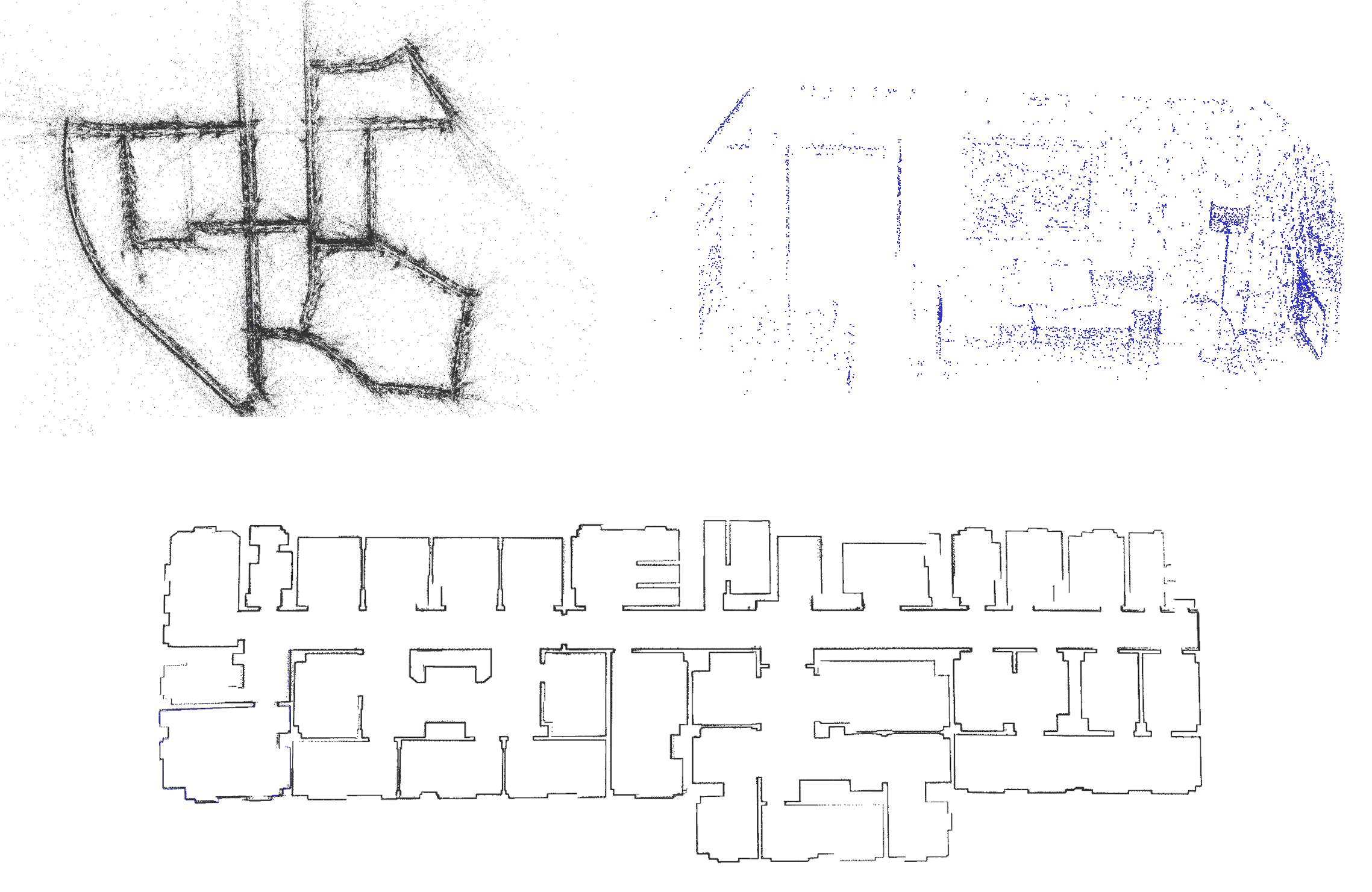
We validated our architecture using multiple 2D-LiDARs (in combination also with wheel odometry), stereo and RGB-D cameras, resulting in outcomes similar to ad-hoc state-of-the-art systems in all scenarios - as illustrated in Fig. 1.
The remainder of this paper is organized as follows: Sec. II presents a brief overview synopsis of multi-modal \glsxtrprotectlinksSLAM systems; in Sec. III, instead, we propose an overview of the generic building block of a \glsxtrprotectlinksSLAM system; in Sec. LABEL:sec:approach, we show the multi-sensor our architecture; finally, in Sec. LABEL:sec:experiments we report the results obtained with such an architecture with different sensors configuration.
II Related Work
In the context of \glsxtrprotectlinksSLAM, sensor fusion indicates the capability of a system of processing multiple cues at the same time. Multi-modal \glsxtrprotectlinksSLAM could dramatically improve the system performances in various scenarios, especially when those are highly dynamic. In the past years the community addressed this topic, investigating ways of integrating multiple cues in the same system. A possible way of exploiting multiple cues, is to have a main sensor and a supplementary one. The latter is supports the system initialization or provides specific cues such as the scale. In the context of Visual-\glsxtrprotectlinksSLAM this scenario is very common nowadays. Many state-of-the-art system combine the use of a monocular camera and an \glsxtrprotectlinksInertial Measurement Unit (IMU) to perform \glsxtrprotectlinksSLAM [lynen2013robust, martinelli2014closed, mur2017visual, qin2018vins]. In this sense, the \glsxtrprotectlinksIMU data is integrated over time [forster2015imu] to produce a coarse estimate of the relative motion between two frames and to infer the scale of the state. Similarly, in the work of Pire et al. [pire2017sptam], the wheel odometry computed from encoder readings, might be used to provide a prior in the registration of two frames when using stereo cameras. Lately, Rosinol et al. [rosinol2019kimera] developed Kimera, a \glsxtrprotectlinksSLAM framework which combines camera images (either from a monocular or stereo setup) together with \glsxtrprotectlinksIMU data to construct 3D metric-semantic maps. In the context of LiDAR-based \glsxtrprotectlinksSLAM, Zhang et al. [zhang2015visual] proposed to integrate range measurement and RGB data to estimate the sensor motion. More specifically, the system initially computes the ego-motion through \glsxtrprotectlinksVisual Odometry (VO) (high frequency but low fidelity) and then refines it exploiting scan-matching based \glsxtrprotectlinksLiDAR Odometry (LO) (low frequency, high fidelity). Newman et al. [newman2006outdoor], instead, used the additional cue coming from RGB camera to compute loop-closure trough feature-based \glsxtrprotectlinksVisual Place Recognition (VPR).
In recent years, given the maturity of the \glsxtrprotectlinksSLAM problem, the research community started exploring the standardization and modularization of \glsxtrprotectlinksSLAM systems. In this sense, closed-box architecture that can deal with specific sensors in a pre-determined way leave room to dynamic multi-cues systems. Our work investigates along this research direction. In this context, Schneider et al. [schneider2018maplab] proposed maplab, a framework to manage \glsxtrprotectlinksVIO in every aspect. Therefore, maplab is a Visual-Inertial Mapping and Localization framework which unifies state-of-the-art \glsxtrprotectlinksVIO implementations and map management or localization routines, allowing multi-missions sessions. The authors offer various off-the-shelf implementations of state-of-the-art algorithms and provide an architecture that allows the user to integrate his own package in the framework. In particular, maplab allows to create a single open-loop map for every mission in \glsxtrprotectlinksVIO mode, then stores the map and performs its refinement using efficient off-line algorithms. As in our case, the user can interact with maplab through a console and provide it’s own configuration. Still, this framework is not intended to deal with multiple sensors other than a camera and \glsxtrprotectlinksIMU.
More recently, Blanco-Claraco proposed MOLA [blanco19mola], a modular, flexible and fully extensible \glsxtrprotectlinksSLAM architecture. MOLA combines in a single system multi-sensor capabilities and large map management, while being completely customizable by the user. Examples of configuration parameters can be the type of variable that represents the system state or the back-end in charge of performing global optimization. MOLA has different types of independent sub-modules, each of which has a specific role. In this sense, input modules process raw sensor readings, and act as data sources for front-end modules. The latter exploit standard \glsxtrprotectlinksSLAM algorithm to create nodes and edges of the factor graph, while the back-end creates a unified interface to the underlying global optimization framework - that can be chosen arbitrarily. Finally, map-storage modules are in charge of storing and managing the map. These modules can also dynamically serialize part of the total map to reduce memory usage. MOLA gives the freedom to the user to completely define the front-end module, who must implement some virtual functions for keyframe and factor creation. In our work, instead, we detected some “atomic” modules and their connections to generate expected behaviors, resulting in a more structured architecture that encourages the reuse of sub-modules.
Similarly, Labbé et al. [labbe2019rtab] proposed a multi-sensor graph \glsxtrprotectlinksSLAM system called RTAB-Map. The modularity is intrinsically granted by the use of \glsxtrprotectlinksRobot Operating System (ROS), by which every processing module runs over a \glsxtrprotectlinksROS node. RTAB-Map was originally designed to be an appearance-based loop closure detection approach [labbe2013appearance], that was focused on memory management to deal with long-term mapping sessions. Subsequently, RTAB-Map has been highly expanded, resulting now in a Visual/Lidar \glsxtrprotectlinksSLAM open-source library. RTAB-Map can be used in two modalities. The first one, consists in a “passive” map manager, that takes as input odometry measurement - generated by some external system - along with raw visual information. In this case, the system maintains the map, detects loop closures and provides highly efficient memory management. In the ”active” modality, RTAB-Map is able to generate itself the odometry information, processing LiDAR or Visual data. In this sense, a great variety of cues can be digested at the same time in a single framework. Still, to extend the system, one has to completely develop a processing modules that given raw sensor reading provides ego-motion estimation.
Most of the concept we adopt and extend have been previously explored in the work of Colosi et al. [colosi2019better]. Here the authors defined a taxonomy of a generic graph-based \glsxtrprotectlinksSLAM system. In this definition, each presented component is responsible for a single task, clearly defined by its input, outputs and mission. Though, the authors focused single sensor scenarios.
The partition of a \glsxtrprotectlinksSLAM system in components is also investigated in the survey on Younes et al. [younes2017keyframe]. In this work, the authors design a generic \glsxtrprotectlinksSLAM flowchart made by several building blocks. Furthermore, they explain for each of them the expected functionalities and the current state-of-the-art implementations available. Even though, this work is only restricted to monocular camera systems. Still, the idea behind the architecture is reasonably general and might be extended to more generic graph-based \glsxtrprotectlinksSLAM system, as we do in our work.
III Taxonomy of a Graph-Based SLAM System


