Driving Datasets Literature Review
for
BRITE: Bus RapId Transit systEm
Summer Internship 2019
![]()
Student: Charles-Éric Noël Laflamme
Supervisor: Philippe Giguère philippe.giguere@ift.ulaval.ca
Cosupervisor: François Pomerleau francois.pomerleau@ift.ulaval.ca
Laval University
Québec City, Canada
August , 2019
Introduction
For the last decade, the progress made in the autonomous driving scientific community and industry has been exceptional. With the rise of deep-learning and better hardware, algorithms embodying the different aspects of driving, such as lane following, obstacle detection, semantic segmentation, tracking, and motion estimation have reached unprecedented performance. Although there are still no SAE Level-4 self-driving vehicles as of yet, recent developments in robotics and machine learning could soon make this aspiration a reality.
The availability of training data is a critical factor to the growth and success of autonomous driving. Although more powerful than traditional machine learning techniques, deep learning algorithms require a particularly massive amount of data for training and testing purposes. Moreover, in order to assimilate the entire driving process complexity and be reasonably safe, algorithms need to account for all possible real world scenarios, thus demanding highly dynamic and diverse datasets. Finally, it is often dangerous, costly and time-consuming to test driving algorithms on real vehicles.
This present document is a survey of the different autonomous driving datasets which have been published up to date. The first section introduces the many sensor types used in autonomous driving datasets. The second section investigates the calibration and synchronization procedure required to generate accurate data. The third section describes the diverse driving tasks explored by the datasets. Finally, the fourth section provides comprehensive lists of datasets, mainly in the form of tables.
1 Sensors & Hardware
In order to achieve reliability and robustness, a wide variety of sensors are usually employed in autonomous vehicles. The diversity of sensing modalities also help mitigating difficult conditions, as their failure modes will be somewhat uncorrelated. These sensors can be categorized into two main groups, namely exteroceptive and proprioceptive sensors.
1.1 Exteroceptive Sensors
Exteroceptive sensors are used to observe the environment, which in the case of autonomous vehicles means roads, buildings, cars, pedestrians, etc. The most common exteroceptive sensors for autonomous vehicles are cameras and range-sensing sensors.
1.1.1 Cameras
Cameras come in a variety of types and models. They are passive sensors meaning that they do not need to emit a signal to capture information, thereby limiting possible interference with other sensors. However, they are impacted negatively by illumination and weather conditions, due to their passive nature.
The most common type of camera is the monocular color camera. Being accessible, low-cost and straight-forward to use, monocular cameras have benefited from the majority of computer vision work of the last decades. Thus, most object detection, segmentation and tracking algorithms have been developed for these monocular cameras.
While driving, humans make use of their stereoscopic vision and focal distance information in order to judge depth and, for example, perform object avoidance. Human vision has also better resolution and a far wider field of view than most monocular cameras. In order to bridge the gap between 2D and 3D object detection and to gain more spatial information, monocular cameras are often used in stereo or multi-view systems. These setups are usually preferred because they present additional depth information, offer redundancy and provide a broader field of view. In order to be precise, these systems need to be calibrated methodically. A more detailed description of the calibration procedure can be found in Section 2. Some manufacturers also offer precalibrated stereo camera systems, which can save time.
An alternative to arrays of cameras are omnidirectional cameras. These offer panoramic 360 degrees images, and are consequently often used to gain maximum information about a surrounding area. This can be highly beneficial for tasks such as localization and mapping. However, they tend to suffer heavily from lens distortion, which can affect the accuracy of a given task. Fish eye lens are also used in a similar fashion.
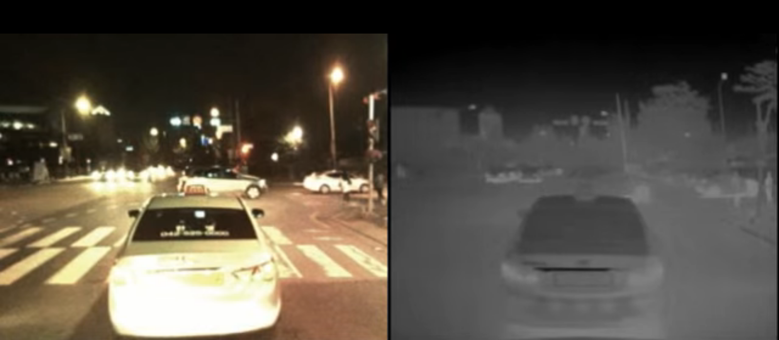
Other types of specialized cameras have been used in the past. For instance, to make up for the poor camera performance at night, thermal cameras and infrared cameras have been used for tasks such as pedestrian detection [43].
Another type of cameras gaining interest are event cameras, which output pixel-level brightness changes instead of standard intensity frames. They offer an excellent dynamic range and very low latency (in the order of s), which can be quite useful in the case of highly-dynamic scenes. However, most already-developed vision algorithms cannot be readily applied to these cameras, as they output a sequence of asynchronous events rather than traditional intensity images. Nevertheless, some autonomous vehicle datasets with event cameras have now been published [11].
Finally, polarized sensors such as the Sony Pregius 5.0 MP IMX250 sensor have also recently reached better performance, which could potentially offer a higher level of detail. Polarization channels are often less affected by illumination changes and weather. They are also quite sensitive to a surface roughness, which could help with the detection of vehicles [34]. However, no public autonomous driving datasets employing a polarization camera have been released, as of yet.
1.1.2 Range-sensing devices
LiDARs, which stands for Light Detection and Ranging, detect objects and map their distances with great spatial coverage, in all lightning conditions. As such, they have been a sensor of choice for autonomous driving applications.
The technology works by illuminating a target with an optical pulse, and measuring the characteristics of the reflected signal return in the same way a radar would detect reflected radio waves. They are much more accurate than radars, but their performance deteriorates from weather conditions such fog, rain or snow. They can also sometimes have trouble with detecting objects at close range.
LiDARs also come in a variety of formats, which can be split into two main families: i) mechanically spinning LiDARs and ii) solid-state LiDARs. While solid-state LiDARs are significantly cheaper, they suffer from a limited field-of-view compared to mechanical LiDARs. Solid-state LiDARs also tend to have a higher noise-to-signal ratio. They have also appeared much more recently than mechanical LiDARS. For all these reasons, most LiDARs used in autonomous datasets have been using either 2D or 3D mechanical LiDARs with often 360 degrees field-of-view. However, recent developments in solid state LiDARs are promising and they are slowly closing the performance gap.
It should be noted that LiDARs can scan a large amount of points at a very high rate, which can be a challenge for any algorithm run time.
In order to mitigate LiDAR limitations when it comes to adverse weather or close-range sensing, radars are also used as a range-sensing technology. Being a more mature sensor than LiDARs, radars are often much cheaper and lightweight, while also being able to determine the speed of its target. Nevertheless, they suffer from very poor spatial resolution, the difficulty of interpreting the received signals, and a much worse accuracy than LiDARs.
Finally, sonars are also used in the industry. While also cheap, sonars have very limited range and precision in addition to being susceptible to weather conditions. They are mainly used for nearby obstacle detection.
1.2 Proprioceptive Sensors
Proprioceptive sensors measure values internally to a given system. In the case of an autonomous vehicle, these measurements include linear and angular positions, speed and acceleration. Most modern cars are already equipped with a plethora of proprioceptive sensors. Wheel encoders are used for odometry, tachometers are used for speed, and IMUs can monitor acceleration changes. These sensors are often accessible through the vehicle’s CAN bus.
However, the accuracy of sensors from car manufacturers are typically too low for autonomous vehicles applications, especially in the case of IMUs. For mapping purposes, the IMU measurements and odometry provide a point-matching algorithms such as Iterative Closest Point (ICP) [10] with an initial transformation guess, which is crucial to the algorithm performance (both in terms of speed and robustness). In order to reach a higher level of precision, most autonomous vehicle datasets use a navigation-grade IMU along with a GPS. Autonomous datasets dedicated to mapping and localization also often use an RTK GPS, which can provide centimeter-level accuracy, in order to compare the localization algorithms to a ground truth.
2 Calibration & Synchronization
In order to achieve coherent data alignment, every sensor needs to be calibrated and synchronized. Below we describe both spatial alignment (calibration) and temporal alignment (synchronization).
2.1 Calibration
Calibration usually refers to a spatial-referencing process by which the relative coordinate frames of all sensors are established. For cameras, the calibration is essential to accurately measure object and distances on a scene for stereo camera setups. Camera calibration or camera resectioning is often split into intrinsic and extrinsic parameters retrieval. Intrinsic parameters refer to the camera’s inherent parameters such as focal length, principal point coordinates and distortion coefficients, to be used in image rectification. On the other hand, extrinsic parameters denote the coordinate system transformations from 3D world coordinates to 3D camera coordinates. These parameters are retrieved using referenced calibration points, called fiducial markers, usually with a checker board target with known dimensions [119].
Once camera-to-camera calibration is achieved, stereoscopic depth reconstruction can be performed for all overlapping pixels. The additional depth channel can then be exploited by various machine learning algorithms to seize additional object features which can lead to better results.
The depth channel derived from stereoscopic reconstruction can be as dense as the camera, depending on the texture in the scene. However, it can be strongly affected by the level of illumination in the environment. It is also far less precise at longer ranges, with the distance accuracy decreasing in . Range sensors, such as LiDARs, are often far more precise and reliable at estimating object distances, but their measurements significantly less dense than cameras.
In a similar fashion, camera-to-range calibration can be achieved using reference plane surfaces [37]. However, the LiDAR-camera measurements fusion is not as straight-forward as stereoscopic reconstruction, because LiDAR data is a lot sparser than camera images. In order to create a depth mask, a LiDAR point cloud needs to be projected on the image plane and then upsampled. It is also possible to instead project the RGB channels onto the LiDAR point cloud to generate a colored point cloud. This approach is generally used by mapping and localization tasks, by providing extra information to a point-matching algorithm.
Finally, motion-sensing devices are also calibrated with each sensor using hand-eye calibration [41] in order to reference the measurements to the inertial navigation system (INS). This is particularly important for localization and mapping tasks such as SLAM, where the inertial and odometry measurements are used as a first estimate for the new position and orientation, which is critical to these algorithms’ performance.
2.2 Synchronization
While calibration addresses the spatial alignment of sensors, synchronization temporally matches measurements together. Driving is a highly-dynamic process within a rapidly-changing environment, making the synchronization process critical for data temporal alignment. In order to synchronize these different measurements, sensors are often triggered externally. The measurements of each sensor are also timestamped with a system clock. When sensors have different acquisition rates, and thus different timestamps, the measurements can either be interpolated or the closest measurement can be selected, depending on the use case.
The exposure time of a camera is nearly instantaneous and should not yield bad data alignment. However, most rotatory LiDARs execute a full rotation in about 0.1 . This scanning speed is considerably slower than the car speed, which can introduce distortions in the point clouds. Techniques have been developed in order to account for the vehicle’s motion within a LiDAR scan [65].
3 Tasks
Most autonomous driving approaches up to date have tried to deconstruct the complex driving process into different smaller and simpler sub-tasks. With this modular approach in mind, each dataset generated for the autonomous vehicle community have more often than not revolved around one or many of these specific tasks. Below, we enumerate the most popular ones.
3.1 Stereo Vision
As mentioned before, driving algorithms can benefit from having additional depth information. One of the simplest ways to acquire such 3D information is through stereo vision. Stereo vision is the task in which the depth of a scene is triangulated by identifying common features in two images taken from cameras mounted next to each other. In the case of driving, challenges for stereo vision include reflective and shiny surfaces such as car bodies. Repetitive structures like fences and transparent surfaces (glass) are other common failure cases.
Datasets dedicated to 3D reconstruction usually offer pixel-wise depth maps as a ground truth. Often, they have been generated by interpolating 3D LiDAR point clouds and by fitting 3D CAD models onto individual objects.
It should be noted that with the rise of recent improvements in deep learning, monocular depth evaluation has also taken interest. In this case, the depth map is estimated using contextual information from a single image [55]. Readers are referred to [33] for a complete survey on stereo vision and other 3D reconstruction algorithms.
3.2 Motion Estimation
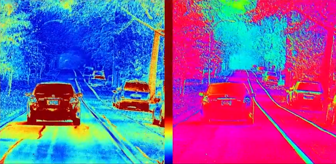
Because driving involves multiple objects moving at high speed, capturing the motion of objects in an image might yield desirable information. Optical flow, defined as finding the motion at each image location between consecutive frames, is one way of representing motion in a dense manner. Optical flow thus extracts additional motion information, which can be of particular importance for other tasks such as localization, ego-motion and tracking.
Optical flow is restricted to monocular 2D images, which makes the retrieval of 3D motion challenging. Scene flow is therefore defined as a generalized version of optical flow, where frames of stereo or multi-camera setups are used to establish motion.
Datasets dedicated to optical and scene flow usually offer optical flow fields, where a vector describing the motion for each pixel in the next or previous frame is provided. Retrieving ground truth for both optical flow and scene flow is a time-consuming and tedious process and is often done by matching the image objects to 3D LiDAR maps.
An extensive survey on the state-of-the-art algorithms for optical and scene flow can be consulted in [113].
3.3 Object Detection
One of the first and foremost aspects of driving is the awareness of its surrounding. Whether it be pedestrians, other vehicles, traffic signs or obstacles, the detection and recognition of different objects in a scene is crucial to the safety and smooth functioning of an autonomous vehicle. Object detection addresses this task by determining the presence and localization of different predefined classes of objects in a scene.
Being an important and well-defined task, object detection has benefited from a considerable amount of attention in the computer vision and autonomous vehicle community. However, object detection still faces challenges. This is notably because of the wide variety of objects, weather conditions and illumination in a driving scene, along with heavy occlusion and truncation of objects [72].
Object detection itself can be split into subcategories depending which modality is used to detect object, or what object itself is to be detected.
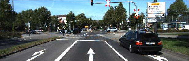
Most object detection is done strictly on 2D images, hence the name 2D object detection. Each object is localized within the image, in pixel coordinates, as illustrated in Figure 3.3. However, it should be noted that recent approaches have tried to include 3D features from either point cloud data [20] or stereo reconstruction [19] in order to generate a more robust detection. Moreover, it is also possible to localize objects relative to the vehicle position in 3D space. This is commonly referred as 3D object detection, and is depicted in Figure 3.4.
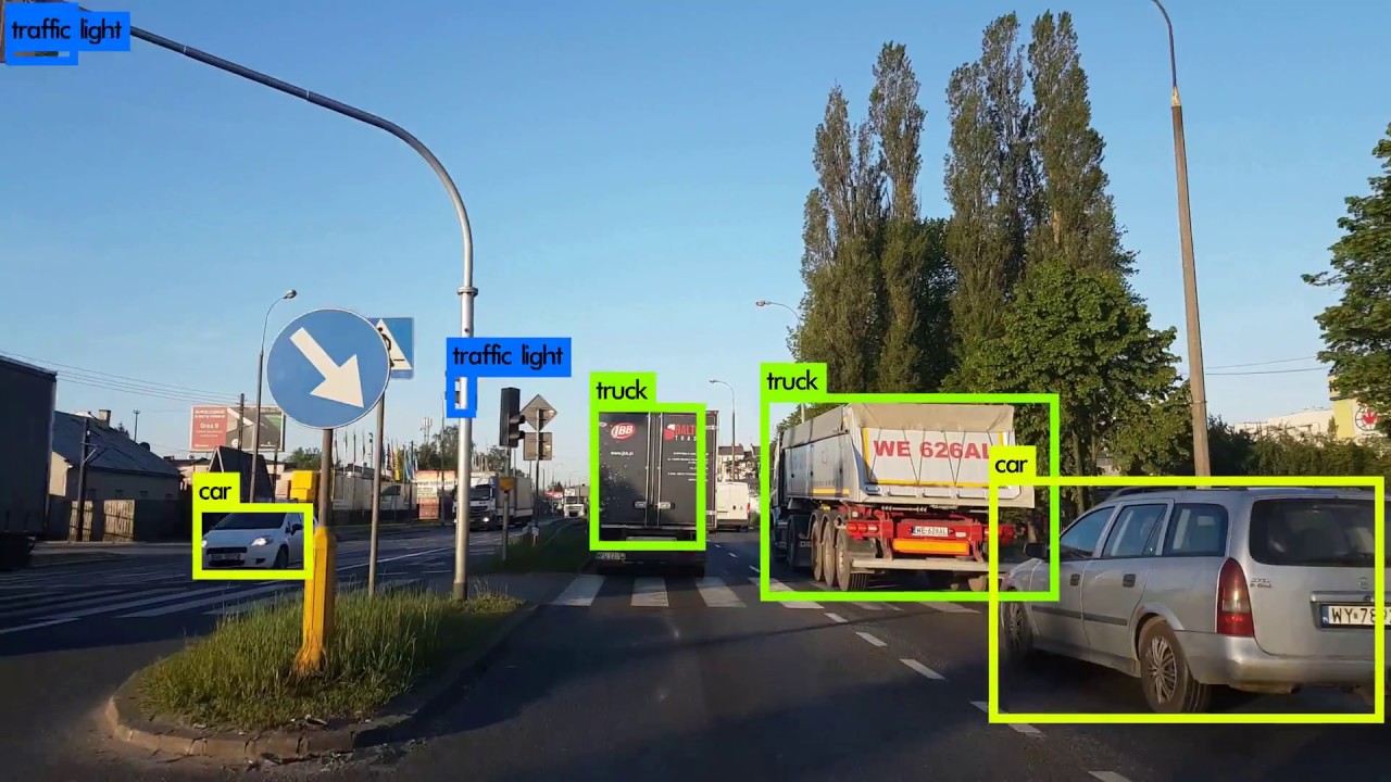
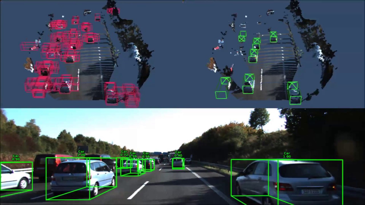
Datasets dedicated to object detection usually contain annotated data frames with 2D or 3D bounding boxes, which encloses the different objects, as ground truth.
3.4 Tracking
Driving is a dynamic process with high-speed moving objects. Therefore, object detection is often insufficient in order to avoid collisions during path planning. Driving algorithms should not only predict the location of objects in a scene, but also their velocity and acceleration. In order to do so, tracking algorithms are used, which try to predict future positions of multiple moving objects based on the history of the individual positions.
A popular and intuitive approach to tracking is tracking-by-detection. An object-detection algorithm is first used to detect targets in each frame, which then need to be associated with each other over multiple frames. While efficient, this approach however suffers from detection errors and from the inherent difficulties of performing data-association. Tracking can also suffer if objects are momentarily occluded, as illustrated in Figure 3.5. It should be noted that pedestrian tracking is of particular interest, as they are the most vulnerable users of the road [28].
In order to predict a target trajectory in 3D, range information is most certainly needed for tracking. As mentioned before, such information can be obtained either by 3D reconstruction from cameras or from LiDAR point clouds, alone or through some sensor fusion process.
Just like object detection, tracking datasets usually contain annotations of data frames in the form of bounding boxes and labels, which are coherent over multiple frames, as a ground truth.
A thorough review on state-of-the-art tracking techniques is available in [27].
3.5 Semantic Segmentation
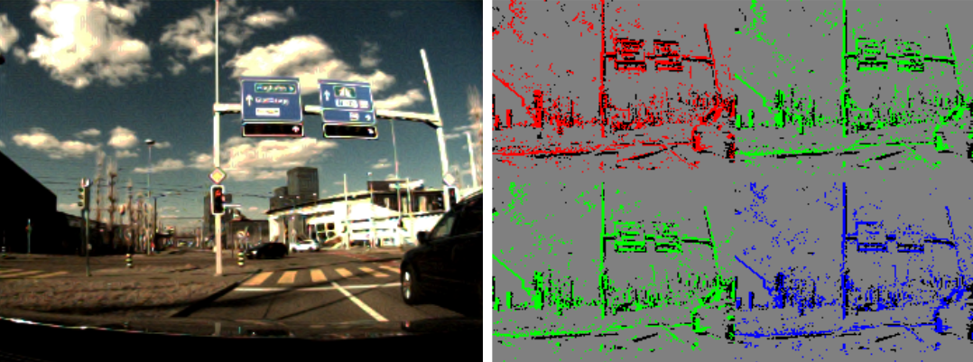
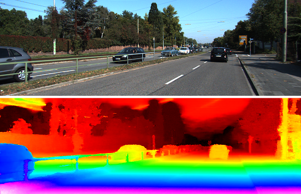
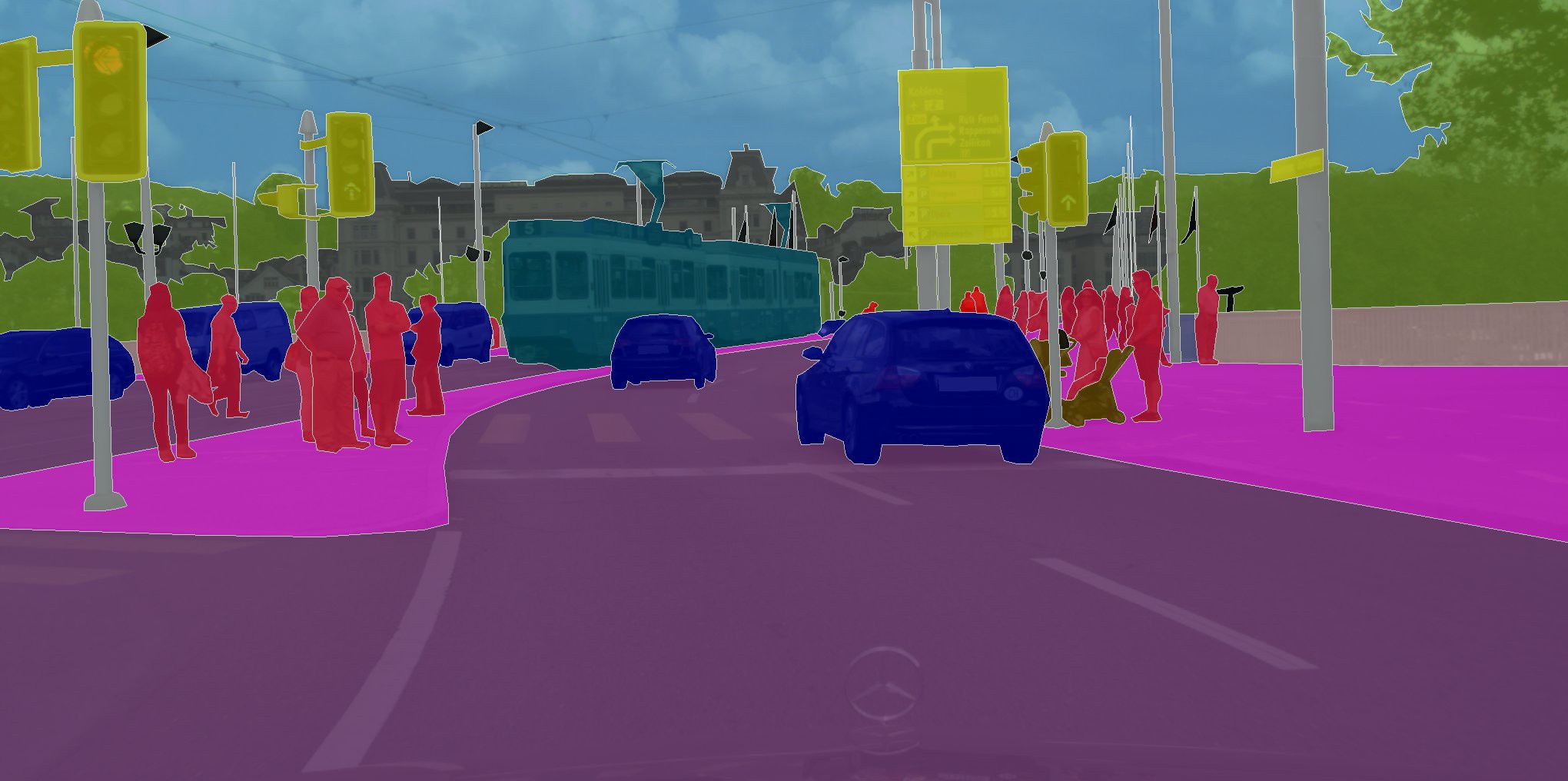
Some objects such as roads, sidewalks and traffic lines are not well-defined by bounding boxes. Consequently, they need a more flexible representation, often down at the pixel-level. This problem is referred to as semantic segmentation.
Semantic segmentation is indeed similar to object detection in the way that it tries to locate different predefined classes of objects in a scene. However, instead of using bounding boxes to localize objects, each pixel of an image is assigned to a class, as seen in Figure 3.6. The segmentation mask therefore offers a more dense and complex classification and localization, which can provide a better understanding of the scene. Semantic segmentation faces the same challenges as object detection such as occlusion, truncation and shadows, but also requires more complex computation. However, with model compression, pruning and hardware acceleration, it can reach real-time execution [91].
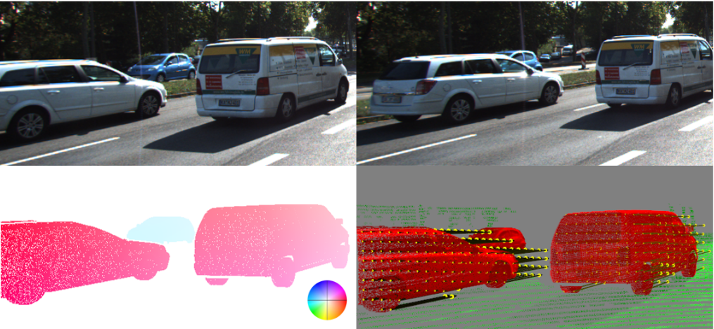
A more refined version of semantic segmentation is instance segmentation, which not only classifies each pixel in a class, but also separates instances of the same class. Unlike semantic segmentation, instance segmentation thus provides information about each instance such as shape and position. Instance segmentation is particularly important to assess the trajectory of individual objects, for example vehicles, cyclists or pedestrians.
It should also be noted that in the case of driving, algorithms usually have access to multiple time frames of data. Methods which impose algorithms to be temporally coherent can improve segmentation accuracy and robustness.
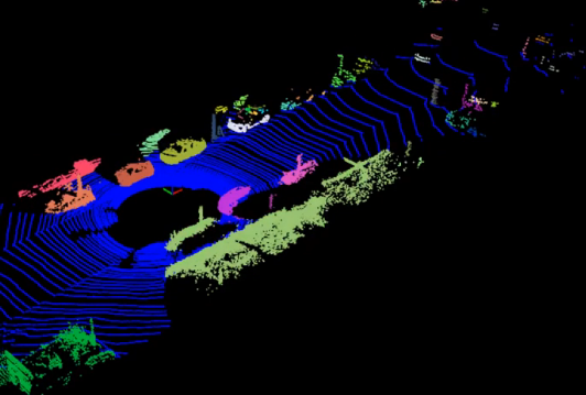
Just like object detection, most of the previous work dedicated to segmentation has been done strictly on 2D images. However, shape and size are important features which cannot be exploited in the 2D space.To capture such information, LIDARs can of course be used.
It it also possible to train semantic segmentation models strictly on point cloud data. However, generating accurate point cloud labels, such as the one displayed in Figure 3.7, is a tedious and time consuming task.
Given the importance of identifying drivable spaces, road and lane segmentation is of particular interest for autonomous vehicles. Along with spatially segmenting the road and lane itself, some algorithms also try to establish the host and neighbor lanes along with their direction. This information is particularly useful for tasks such as lane keeping, merging and turning.
Datasets dedicated to semantic segmentation usually annotate data frames with pixel-wise segmentation masks as ground truth, or in the case of 3D segmentation, voxel-wise masks.
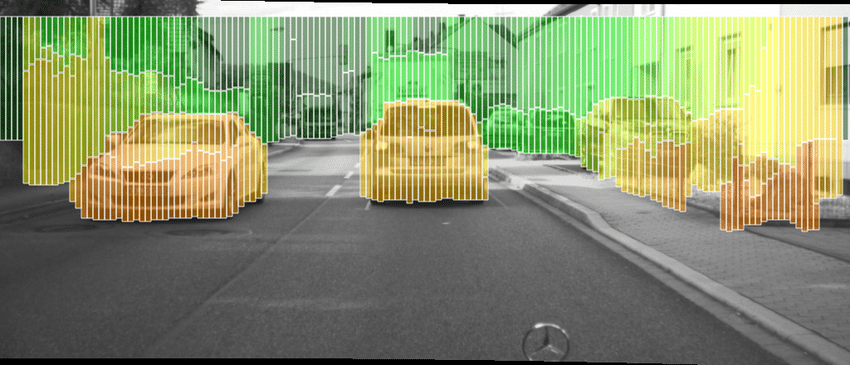
In order to alleviate computational burden of semantic segmentation, the stixel representation has been suggested [24]. Stixels create a medium-level model of the environment, compressing pixel-wise information into vertical strips. An example of a stixel segmentation can be seen in Figure 3.8.
3.6 Localization
Localization is a task critical to any mobile robot. In order to lay the appropriate path planning, a vehicle needs to know where it is exactly regarding its environment. Different approaches have been used in the past for localization.
The most straightforward one is the use of GPS and IMU sensors. While this combination of sensors is the most accessible and low-cost approach, it lacks the requirements needed for autonomous driving. Even with dead reckoning estimation from the IMU, commercial-grade GPS are simply too inaccurate. While RTK technology offers the precision needed for autonomous driving, the accuracy of the signal is highly dependant on the environment, urban setting with high buildings being particularly prone to errors from interference.
Simultaneous localization and mapping (SLAM) is another popular approach. It tries to generate a map on the fly using a vehicle’s sensors, while estimating at the same time the position of the vehicle in the constructed map. It has the advantage of not needing any prior information about the environment, meaning this approach can work in any setting. However, SLAM still faces challenges as it is computationally heavy and needs to handle large-scale environments in real-time. Moreover, SLAM is prone to diverge in difficult environments. RTKs positioning is often used as ground truth for SLAM, given an appropriate signal reception.
Using pre-constructed maps is an alternative to SLAM that alleviates the problem on generating a map on the fly. Using a point-matching algorithm or visual landmark searches approach, a priori map-based localization algorithms can be highly accurate. However, a major weakness of these approaches is the fact that roads themselves are not completely static, and therefore the maps used for localization have to be updated for construction work or weather changes.
For further details, a complete survey on state-of-the-art techniques for localization can be found in [53].
3.7 Behaviour Analysis
If driving vehicles are one day a reality, they will most likely have to interact with humans. Whether it be infering a pedestrian’s intention to cross a street, identifying a driver’s intent to perform a certain action or spotting potentially reckless maneuvers, autonomous vehicles need to have a high-level understanding of surrounding human behavior. The assessment of human behavior is therefore paramount for any autonomous driving applications.
While the task of behavior assessment is not as bounded as previously described tasks, recent datasets have tried to capture such human behavior. For instance, some datasets [45, 78, 79] have tried annotating each of the driver’s actions. Such data can be used to develop action-predicting algorithms, which can then be used to assess if a driver’s maneuver is completely safe or not.
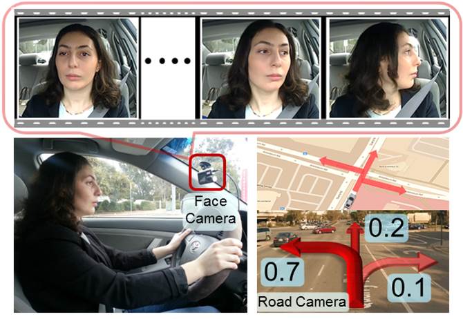
Driver face monitoring is also a modality often used in order to predict maneuvers or visual focus, as shown in Figure 3.9. Some datasets even project the driver’s gaze onto the road image, in order to know exactly on what the driver is focusing [73]. Such information can be used to established the driver’s attention level for a safer driving experience.
Another important behavior assessment task is driving style recognition. Driving style can be defined in various ways including fuel consumption, brake-use, distance-keeping and aggressiveness. Establishing a driver’s style can be used to adjust driving strategy, such as lane merging or alert the driver if he is being reckless [9].
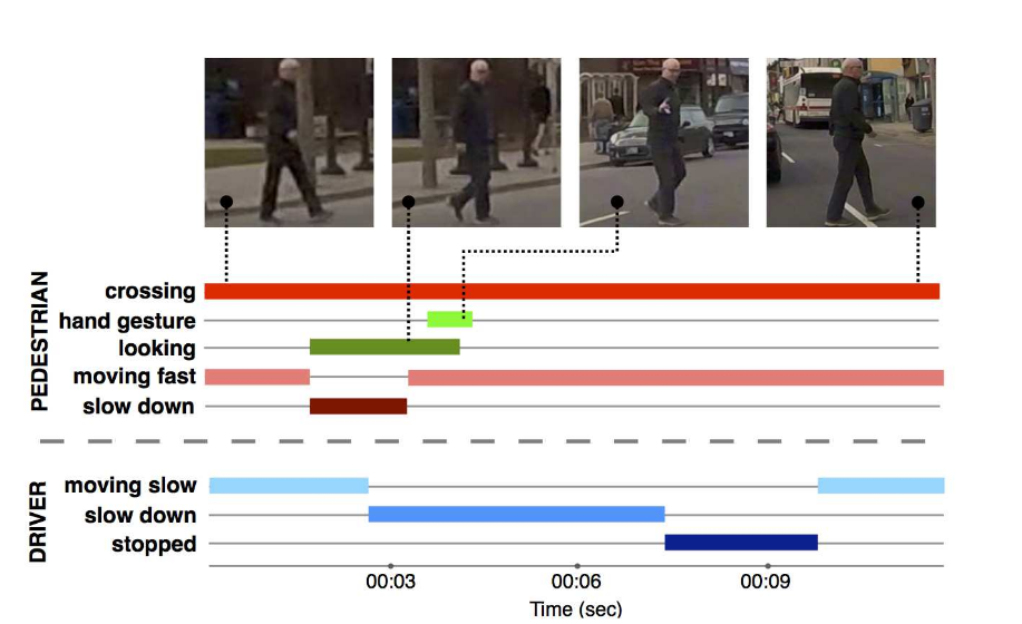
Finally, some datasets [52] have also collected data regarding pedestrian intention, as displayed in Figure 3.10. Algorithms can then be trained to recognize whether a pedestrian wants to cross a street or not, and help prevent collisions.
4 Datasets
The following section presents the available open driving datasets, sorted by their respective task. It should be noted that only datasets which are in a real-driving context were selected. Therefore, synthetic datasets are not presented. Moreover, datasets acquired from terrestrial vehicles which are not cars, such as Segways or another robotic platform are also ignored. Finally, stationary-acquired datasets are also ignored.
4.1 Object detection
The Table 4.1 table presents the autonomous driving datasets available for object detection and tracking, ordered chronologically. First of all, the shear size of the table is a great testimony to the level of attention the field has received in the autonomous driving community. Indeed, most datasets in this table have been published during the past three years, demonstrating that this is an active field. The table also attests the recognition autonomous driving has gained in the industry, with most of the major and recent datasets being published by companies such as Waymo, Aptiv, Lyft, Bosch and Hesai.
Moreover, by ordering the datasets by year, several interesting trends can be observed. The number of annotated frames per dataset seems to have increased considerably throughout the year. This phenomenon can probably be explained by the surge of deep learning in computer vision, which demands a vast amount of data. Furthermore, deep learning also gain from data diversity, which can explain why recent datasets seem to encompass more driving situations such as weather, time and traffic variety.
The interest in multi-modal learning and the democratization of LiDAR sensors can also be observed in this table, with most of the recent datasets incorporating LiDARs and other sensing devices. The annotations have also been refined in the recent years, with the arrival of more annotated classes and 3D bounding boxes.
Finally, the table also presents object detection datasets which are aimed at more specialized tasks such as pedestrian detection or traffic sign detection. However, these kinds of niche datasets seem to be less frequent nowadays, which suggests that such specialized task have become trivially easy for object detection algorithms. It also seems that the state-of-the-art emphasizes rather on object detection generalization.
4.2 Object segmentation
Likewise, Table 4.2 presents the driving datasets aimed at semantic and instance segmentation. While object detection and tracking are analogous to semantic and instance segmentation, there seems to be considerably less datasets dedicated to the latter tasks. This can presumably be attributed to the fact that generating segmentation annotation is a time-consuming and costly process.
Nonetheless, comparable trends can be observed from the segmentation datasets. Recent datasets are bigger and more diverse. The use of LiDARs and point cloud annotations are also very recent. Finally, most recent datasets are, again, published by companies.
4.3 Lane detection
The Table 4.3 presents lane detection datasets, another important part of vehicle perception. It can be thought as a special case of object detection or semantic segmentation. In fact, the consensus on the annotation type among the autonomous driving community does not seem to be established. While most datasets use spline lines to describe lanes, other datasets use pixel-wise annotations, bounding boxes or point cloud annotations.
It should be noted that while recent datasets have become larger and more exhaustive, there seems to be no datasets explicitly exploring damaged lane markings and lane-detection fail cases.
4.4 Optical flow
The list of optical flow datasets presented in Table 4.4 is noticeably shorter than for the previous tasks. The lack of driving optical flow datasets can most probably be explained by two causes. First, measuring ground truth for optical flow is a complicated and precise task which can be very hard to do in a highly-chaotic environment such as driving. This is why most benchmarked optical flow datasets are usually done in a controlled environment [3] or using synthetic data [15]. Secondly, most modern computer vision algorithms do not make use of optical flow data and thus the field has been losing interest over the years. Nevertheless, the KITTI FLOW 2015 [64] dataset offers a precise optical flow benchmark, with 3D fitted CAD models as ground truth. On the other hand, the Heidelberg datasets [50, 63] provide challenging and diverse cases for optical flow to assess algorithms robustness.
4.5 Stereo
A similiar trend can be observed for stereo datasets in Table 4.5. Once again, retrieving accurate ground truth for highly-dynamic scenes can turn out to be a challenge even with the use of LIDARs, as motion distortion can have considerable effect. Consequently, commonly used benchmarks are either static [86] or synthetic [15].
Stereo datasets are nonetheless useful in order to evaluate sensor fusion, especially since multi-modal learning is becoming more important. One interesting trend which can be observed in this table is the increase of resolution over time, which is also valid for every other tasks. This improvement in resolution embodies the hardware breakthroughs made over the years, but also begs the precision-performance question which future algorithms will have to face.
4.6 Localization and mapping
It also seems that localization/mapping datasets has not benefited from the same level of attention as object detection, which can be observed by the size of Table 4.6. Most mapping and localization algorithms do not make use of deep-learning algorithms, meaning the need for large and diverse amount of data is not as critical. It can also be observed that localization and mapping datasets have been using LiDARs a lot earlier than those for object detection.
Centimeter precise measurements from DGPS or RTK are available for visual or point cloud odometry for most datasets. However, there is no datasets that provide ground truth for SLAM or mapping. Only qualitative evaluation and loop-closing can be used to evaluate the quality of a generated map.
4.7 Behavior
Finally, Table 4.7 presents datasets which focus on behavioral aspects of driving. It can be noted that these kind of datasets have only recently started to gain attention. Also, since they are so recent, there is no clear annotation or methodology defined to quantify and capture driving behaviors. These datatsets are thus highly different from one another. It should also be noted that a recent trend tries to predict steering angle, brake or gas pedal, for use in end-to-end learning.
Name Provider Cit. Year Location Diversity Traffic Sensors Annot. Track. Frames Classes R S N D U H Re Ru C Vi Li GPS Th If Ra 2D 3D (k) PandaSet [74] Hesai & Scale N/A 2019 Silicon Valley ? ? ? ? ? ? ? ? ? X X** X X X 60 28 nuScenes [16] Aptiv 16 2019 Boston, Singapore X X X X X X X X X X X 40 23 Waymo Open [106] Waymo Inc. N/A 2019 United States X X X X X X X X X X X X 200 4/5 Lyft Level5 [48] Lyft N/A 2019 Palo Alto, London, Munich ? ? ? ? ? ? ? ? ? X X X X X X 55 23 H3D [76] Honda Res. Inst. 4 2019 San Francisco X X X X X X 27 8 Boxy [7] Bosch N.A. Res. 0 2019 Unknown X X X X X X X 200 1 BLVD [111] VCCIV 2 2019 Changshu X X X X X X 120 3 Road Damage [61] University of Tokyo 31 2018 Japan X X X X* X 9 8 KAIST Multispectral [22] KAIST 13 2018 Seoul X X X X X X X X X X X 8.9 6 BDD [115] U. of California 103 2018 San Francisco, New York X X X X X X X X X X X X 100 10 Apollo Open Platform [2] Baidu Inc. N/A 2018 China X X X X X X X X X X 20 4/5 EuroCity [13] Delft U. of Tech. 6 2018 European Cities X X X X X X X 47 7 FLIR Thermal Sensing [32] FLIR Sytems Inc. N/A 2018 Santa Barbara X X X X X X X X 14 5 NightOwls [71] Oxford U. 3 2018 Germany, Netherlands, UK X X X X X X X X X 279 4 TuSimple [103] TuSimple N/A 2017 Unknown X X X X X 12 1 NEXET [100] Nexar N/A 2017 Around the globe X X X X X X X X X 55 5 Multi-spectral Object Detection [97] U. of Tokyo 5 2017 Tokyo X X X X X X 7.5 5 Bosch Small Traffic Lights [8] Bosch N. A. Res. 45 2017 San Francisco X X X X X X X 13 15 CityPersons [118] Max Planck Inst. (Info.) 105 2017 Germany, France, Switz. X X X X 5 4 Udacity [104] Udacity N/A 2016 Mountain View X X X X 34 3 JAAD [80] York University 16 2016 Ukraine, Canada X X X X X X X X 88 1 Elektra (CVC-14) [95] Auton. U. of Barcelona N/A 2016 Barcelona X X X X X X 10 1 Tsinghua-Daimler Cyclist [110] Daimler AG 41 2016 Beijing X X X 15 6 KAIST Multispectral Pedestrian [44] KAIST 195 2015 Seoul X X X X X X X X 95 3 Highway Workzones [89] CMU 21 2015 United States X X X X X 17 9 KITTI [94] Karlsruhe Inst. of Tech. 5415 2013 Karlsruhe X X X X X X X X X X X 15 2 German Traffic Sign [96] Ruhr U. 298 2013 Germany X X X X X X X* X 5 43 LISA Traffic Sign [68] U. of California 382 2012 San Diego X X X X* X 6.6 47 TME Motorway [18] Czech Tech. U. 127 2011 Northern Italy X X X X 30 2 Belgian Traffic Sign [101] ETH Zürich 261 2011 Belgium X X* X 9 62 LISA Vehicle Detection [93] U. of California 333 2010 California X X X X X 2.2 1 TUD-Brussels Pedestrian [107] Max Planck Inst. (Info) 182 2009 Belgium X X X X 1.6 1 ETH Pedestrian [30] ETH Zürich 547 2009 Zürich X X X X X 4.8 1 Caltech Pedestrian [28] Caltech 1009 2009 Los Angeles X X X X 250 1 Daimler Pedestrian [29] Daimler AG 1177 2008 Beijing X X X X 21 1 R: Rain, S: Snow, N: Night, D: Dawn/Dusk, U: Urban, H: Highway, Re: Residential, Ru: Rural, C: Campus, Vi: Video, Li: LiDAR, Th: Thermal Camera, If: Infrared Camera, Ra: Radar *Non-continuous frames **Solid-state LiDAR also velocity also age, gender and direction
Name Provider Cit. Year Location Diversity Traffic Sensors Annot. Frames Classes R S N D U H Re Ru C Vi Li GPS Th Px In Pc (k) PandaSet [74] Hesai & Scale N/A 2019 Silicon Valley ? ? ? ? ? ? ? ? ? X X** X X ? X 60 k 37 SemanticKitti [6] University of Bonn 1 2019 Karlsruhe X X X X X 43 k 28 Highway Driving [49] Korea Advanced Institute of Science and Technology 1 2019 Unknown X X X 1.2 k 10 ApolloScape [42] Baidu Inc. 7 2018 China X X X X X X X X X X X X X 147 k 35 Apollo Open Platform [2] Baidu Inc. N/A 2018 China X X X X X X X 17 k 26 BDD [115] U. of California 103 2018 San Francisco, New York X X X X X X X X X X X X 10 k 40 Wilddash [116] Austrian Inst. of Tech. 8 2018 Around the globe X X X X X X X X X X X 226 30 Raincouver [102] U. of British Columbia 3 2018 Vancouver X X X X X X X X X X 326 3 MightyAi Sample [66] MightyAI N/A 2018 Seattle X X X X X X 200 41 IDD [105] IIIT Hyderabad 6 2018 Hyderabad, Bangalore X X X X X X 10 k 34 Mapillary Vistas [70] Mapillary AB 139 2017 Around the globe X X X X X X X X X* X X 20 k 66 Multi-Spectral Semantic Segmentation [40] U. of Tokyo 11 2017 Tokyo X X X X X X 1.6 k 8 Cityscapes [23] Daimler AG 1729 2016 Germany, France, Switzerland X X X X X 5 k 30 LostAndFound [77] Daimler AG 14 2016 Germany X X X X* X 2 k 37 Daimler Urban Segmentation [87] Daimler AG 67 2014 Heidelberg X X X 500 5 KITTI Semantics [94] Karlsruhe Institute of Technology 5415 2013 Karlsruhe X X X X X X X 200 34 Standford Track [99] Stanford University 146 2011 California X X X X X X 14 k 3 CamVid [14] University of Cambridge 475 2009 Cambridge X X X 700 32 Daimler Pedestrian [29] Daimler AG 1177 2008 Beijing X X 785 1 R: Rain, S: Snow, N: Night, D: Dawn/Dusk, U: Urban, H: Highway, Re: Residential, Ru: Rural, C: Campus, Vi: Video, Li: LiDAR, Th: Thermal Camera, Px: Pixel, In: Instance, Pc: Point Cloud *Non-continuous frames **Solid-state LiDAR
Name Provider Cit. Year Location Diversity Traffic Sensors Annot. Frames Classes R S N D U H Re Ru C Vi Li GPS Px Sp Bx Pc Unsupervised Llamas [47] Bosch N. A. Research 0 2019 California X X X X X X 100 k 5 BDD [115] U. of California 103 2018 San Francisco, New York X X X X X X X X X X X 80 k 11 ApolloScape [42] Baidu Inc. 7 2018 China X X X X X X X X X X X X 170 k 27 CULane [98] University of Hong Kong 42 2018 Beijing X X X X X X 130 k 9 VPGNet [56] KAIST 44 2017 Seoul X X X X X X X 21 k 17 TuSimple [103] TuSimple N/A 2017 Unknown X X X X 6.4 k 4 TRoM [59] Tsinghua University 1 2017 Beijing X X X X X X 712 19 KITTI Road [94] Karlsruhe Institute of Technology 5415 2013 Karlsruhe X X X X X 579 2 Road Marking [108] Honda Research Institute 68 2012 California X X X X X X 1.4 k 23 CalTech Lanes [1] California Institute of Technology 577 2008 Washington, Cordova X X X X 1.2 k 2 R: Rain, S: Snow, N: Night, D: Dawn/Dusk, U: Urban, H: Highway, Re: Residential, Ru: Rural, C: Campus, Vi: Video, Li: LiDAR, Th: Thermal Camera, Px: Pixel,Sp: Spline, Bx: Bounding Box, Pc: Point Cloud
Name Provider Cit. Year Location Diversity Traffic Annot. Ground Truth Retrieval Frames R S N D U H Ru Scene Flow Optical Flow HD1K [50] Heidelberg Collaboratory, Bosch 20 2016 Heidelberg X X X X X Stereo/Lidar Fusion + ICP 1000 KITTI Flow 2015 [64] Karlsruhe Institute of Technology 629 2015 Karlsruhe X X X Stereo/Lidar Fusion + 3D CAD Models 400 KITTI Flow 2012 [36] Karlsruhe Institute of Technology 3508 2012 Karlsruhe X X Stereo/Lidar Fusion + ICP 391 HCI Challenging Stereo [63] Heidelberg Collaboratory, Bosch 57 2012 Hildesheim X X X X X X Stereo + Monoscopic Tracking 10 k R: Rain, S: Snow, N: Night, D: Dawn/Dusk, U: Urban, H: Highway, Ru: Rural
Name Provider Cit. Year Location Resolution Baseline Frames Diversity Ground Truth Env We Il Ti Se Complex Urban [46] KAIST 14 2018 South Korea 1600x1200 47 36 k X X LiDAR ApolloScape [42] Baidu Inc. 7 2018 China 3384x2710 30 5 k X Stereo/Lidar Fusion + 3D CAD Models HD1K [50] Heidelberg Collaboratory, Bosch 20 2016 Heidelberg 1080x2560 30 10 k X X Stereo/Lidar Fusion + 3D CAD Models Elektra (CVC-13) [5] Autonomous University of Barcelona 73 2016 Barcelona 640x480 12 110 X X Manual + 3D CAD Models CCSAD [39] Centro de Investigación En Matemáticas 7 2015 Mexico 1096x822 50 96 k X X - KITTI Stereo 2015 [64] Karlsruhe Institute of Technology 629 2015 Karlsruhe 1240x376 54 396 X Stereo/Lidar Fusion + 3D CAD Models Oxford RobotCar [60] Oxford University 246 2015 Central Oxford 1280x960 24 1 M + X X X X LiDAR Málaga Stereo and Urban [12] University of Málaga 107 2013 Málaga 1024x768 12 111 k X LiDAR Stixel [24] Daimler AG 91 2013 Germany 1024x333 21 2500 X Manual KITTI Stereo 2012 [36] Karlsruhe Institute of Technology 3508 2012 Karlsruhe 1242x374 54 400 X Stereo/Lidar Fusion + ICP Ladicky [54] Oxford Brookes University 91 2012 Leuven 316x256 150 70 Manual Env: Environment, We: Weather, Il: Illumination, Ti: Daytime, Se: Seasons
Name Provider Cit. Year Location Length Frames Sensor Ground Truth Distinctiveness (km) (k) Vi 2DLi 3DLi Ve If Ev Pose Map StreetLearn [67] DeepMind 3 2019 New York, Pittsburgh 1100.0 114 X GPS X Collection of Google Street View panoramas UTBM RoboCar [112] U. of Tech. of Belfort-Montbéliard N/A 2019 Montbéliard 63.4 220 X X X RTK Long-term, day/night diversity, seasons Multi Vehicle Stereo Event Camera [120] U. of Pennsylvania 29 2018 Pennsylvania 9.6 36 X X X GPS/IMU X Event camera, map as ground truth Complex Urban [46] KAIST 14 2018 South Korea 44.8 - X X RTK X Focus on diverse and complex urban scenarios Apollo Open Platform [2] Baidu Inc. N/A 2018 China 3.0 - X RTK Multi-Sensor Localization comma2k19 [85] comma.ai 1 2018 San Francisco, San Jose 2000 + 2400 X GNSS Raw GNSS measurements, long-term Oxford RobotCar [60] Oxford University 246 2015 Central Oxford 1 and 010.5 1000 + X X X DGPS Long-Term, same segment, weather diversity AMUSE [51] Linköping University 12 2013 Linköping 24.4 108 X X GPS/IMU Velocity and height sensors and snow KITTI Odometry [94] Karlsruhe Inst. of Tech. 5415 2013 Karlsruhe 39.2 41 X X RTK Widely-used benchmark for SLAM Málaga Stereo and Urban [12] University of Málaga 107 2013 Málaga 36.8 111 X X RTK Direct sun Cheddar Gorge [92] BAE Systems 13 2011 Cheddar Gorge 31.8 86 X X X DGPS Infrared camera and Countryside mapping The annotated laser data set [114] CMU 11 2011 Pittsburgh 5.0 5 X X - 2D Lidar obstacle detection and SLAM Ford [75] U. of Michigan 177 2010 Michigan 5.1 7 X X X DGPS Omni cameras, precise camera-laser registration Vi: Video, 2DLi: 2D LiDAR, 3DLi, 3D LiDAR, Ve: Velocity Sensor, If: Infrared Camera, Ev: Event Camera
Name Provider Cit. Year Location Volume Diversity Traffic Sensor Annotation Objective R S N D U H Re Vi Fc Li GPS IMU CAN Ev DBNet [21] Shangai Jiao Tong University 4 2018 China 17 X X X X X X X X X X X X - Steering/Velocity Prediction HDD [79] Honda Research Institute 23 2018 San Francisco 104 X X X X X X X X Maneuvers Maneuver Prediction, Causal Reasoning comma2k19 [85] comma.ai 1 2018 San Francisco, San Jose 35 X X X X X - Steering Prediction DDD17 [11] ETH Zürich 31 2017 Switzerland, Germany 12 X X X X X X X X - Steering Prediction Brain4Cars [45] Cornell University 35 2016 United States 22 X X X X X X Maneuvers, Street Maps Maneuver Prediction Dr(eye)ve [73] University of Modena 24 2016 Modena 6 X X X X X X X X Gaze Maps, Pupil Dilation Attention Monitoring JAAD [80] York University 16 2016 Ukraine, Canada 240 X X X X X X Pedestrian/Driver Behavior, Context Pedestrian/Driver Behavior UAH [83] University of Alcalá 29 2016 Madrid 8 X X X X Driver Behavior, Maneuvers Driver Behavior, Maneuver Prediction Elektra (DrivFace) [26] Autonomous University of Barcelona 10 2016 Barcelona - X X Gaze Direction, Facial Keypoints Gaze Monitoring Udacity [104] Udacity N/A 2016 Mountain View 8 X X X X X X - Steering Prediction comma.ai [84] comma.ai 90 2016 San Francisco 7 X X X X X - Steering Prediction DIPLECS Surrey [78] University of Surrey 28 2015 Surrey 0.5 X X X X X - Steering Prediction DIPLECS Sweden [78] Autoliv 36 2015 Stockholm 3 X X X X Maneuvers, Context Maneuver Prediction EISATS (Set 11) [25] University of Auckland 5 2010 Germany, New Zealand <1 X X - Gaze Monitoring R: Rain, S: Snow, N: Night, D: Dawn/Dusk, U: Urban, H: Highway, Re: Residential, Vi: Video, Fc: Face Camera, Li: LiDAR, CAN: Controller Area Network Data, Ev: event-camera
Acknowledgments
This work was supported by NSERC CRD Grant "BRITE: Bus RapId Transit systEm" (511843) and Consortium InnovÉÉ.
References
- [1] Mohamed Aly “Real time Detection of Lane Markers in Urban Streets” In CoRR abs/1411.7113, 2008 arXiv: http://arxiv.org/abs/1411.7113
- [2] “Apollo Data Open Platform”, 2018 URL: http://data.apollo.auto/
- [3] Simon Baker et al. “A Database and Evaluation Methodology for Optical Flow” In International Journal of Computer Vision 92.1, 2011, pp. 1–31 DOI: 10.1007/s11263-010-0390-2
- [4] Aharon Bar Hillel, Ronen Lerner, Dan Levi and Guy Raz “Recent progress in road and lane detection: a survey” In Machine Vision and Applications 25.3, 2014, pp. 727–745 DOI: 10.1007/s00138-011-0404-2
- [5] F. Barrera Campo, F. Lumbreras Ruiz and A.. Sappa “Multimodal Stereo Vision System: 3D Data Extraction and Algorithm Evaluation” In IEEE Journal of Selected Topics in Signal Processing 6.5, 2012, pp. 437–446 DOI: 10.1109/JSTSP.2012.2204036
- [6] Jens Behley et al. “A Dataset for Semantic Segmentation of Point Cloud Sequences” In CoRR abs/1904.01416, 2019 arXiv: http://arxiv.org/abs/1904.01416
- [7] Karsten Behrendt “Boxy Vehicle Detection in Large Images”, 2019 URL: https://boxy-dataset.com/boxy/
- [8] Karsten Behrendt and Libor Novak “A Deep Learning Approach to Traffic Lights: Detection, Tracking, and Classification” In IEEE International Conference on Robotics and Automation (ICRA), 2017, pp. 1370–1377
- [9] Luis Bergasa et al. “DriveSafe: an App for Alerting Inattentive Drivers and Scoring Driving Behaviors” In IEEE Intelligent Vehicles Symposium, 2014 DOI: 10.1109/IVS.2014.6856461
- [10] P.. Besl and N.. McKay “A method for registration of 3-D shapes” In IEEE Transactions on Pattern Analysis and Machine Intelligence 14.2, 1992, pp. 239–256
- [11] Jonathan Binas, Daniel Neil, Shih-Chii Liu and Tobi Delbrück “DDD17: End-To-End DAVIS Driving Dataset” In CoRR abs/1711.01458, 2017 arXiv: http://arxiv.org/abs/1711.01458
- [12] José-Luis Blanco-Claraco, Francisco Angel Moreno and J.. Gonzalez “The Málaga urban dataset: High-rate stereo and LiDAR in a realistic urban scenario” In International Journal of Robotics Research (IJRR) 33, 2014, pp. 207–214
- [13] Markus Braun, Sebastian Krebs, Fabian B. Flohr and Dariu M. Gavrila “EuroCity Persons: A Novel Benchmark for Person Detection in Traffic Scenes” In IEEE Transactions on Pattern Analysis and Machine Intelligence 41.8, 2019, pp. 1844–1861 DOI: 10.1109/TPAMI.2019.2897684
- [14] Gabriel J. Brostow, Julien Fauqueur and Roberto Cipolla “Semantic Object Classes in Video: A High-Definition Ground Truth Database” In Pattern Recognition Letters 30, 2009, pp. 88–97
- [15] D.. Butler, J. Wulff, G.. Stanley and M.. Black “A naturalistic open source movie for optical flow evaluation” In European Conference on Computer Vision (ECCV), 2012, pp. 611–625
- [16] Holger Caesar et al. “nuScenes: A multimodal dataset for autonomous driving” In CoRR abs/1903.11027, 2019 arXiv: http://arxiv.org/abs/1903.11027
- [17] Luca Caltagirone, Mauro Bellone, Lennart Svensson and Mattias Wahde “LIDAR–camera fusion for road detection using fully convolutional neural networks” In Robotics and Autonomous Systems 111, 2019, pp. 125–131
- [18] Claudio Caraffi et al. “A System for Real-time Detection and Tracking of Vehicles from a Single Car-mounted Camera” In IEEE International Conference on Intelligent Transportation Systems, 2012, pp. 975–982
- [19] Xiaozhi Chen et al. “3D Object Proposals using Stereo Imagery for Accurate Object Class Detection” In CoRR abs/1608.07711, 2016 arXiv:1608.07711
- [20] Xiaozhi Chen et al. “Multi-View 3D Object Detection Network for Autonomous Driving” In CoRR abs/1611.07759, 2016 arXiv: http://arxiv.org/abs/1611.07759
- [21] Yiping Chen et al. “LiDAR-Video Driving Dataset: Learning Driving Policies Effectively” In Conference on Computer Vision and Pattern Recognition (CVPR), 2018
- [22] Y. Choi et al. “KAIST Multi-Spectral Day/Night Data Set for Autonomous and Assisted Driving” In IEEE Transactions on Intelligent Transportation Systems 19.3, 2018, pp. 934–948 DOI: 10.1109/TITS.2018.2791533
- [23] Marius Cordts et al. “The Cityscapes Dataset for Semantic Urban Scene Understanding” In Conference on Computer Vision and Pattern Recognition (CVPR), 2016
- [24] Marius Cordts et al. “The Stixel world: A medium-level representation of traffic scenes” In CoRR abs/1704.00280, 2017 arXiv:1704.00280
- [25] Michał Daniluk, Mahdi Rezaei, Radu Nicolescu and Reinhard Klette “Eye Status Based on Eyelid Detection: A Driver Assistance System” In Lecture Notes in Computer Science 8671, 2014, pp. 171–178
- [26] Katerine Diaz-Chito, Aura Hernández-Sabaté and Antonio M. López “A Reduced Feature Set for Driver Head Pose Estimation” In Appl. Soft Comput. 45.C Amsterdam, The Netherlands, The Netherlands: Elsevier Science Publishers B. V., 2016, pp. 98–107 DOI: 10.1016/j.asoc.2016.04.027
- [27] Shilp Dixit et al. “Trajectory planning and tracking for autonomous overtaking: State-of-the-art and future prospects” In Annual Reviews in Control, 2018 DOI: 10.1016/j.arcontrol.2018.02.001
- [28] P. Dollár, C. Wojek, B. Schiele and P. Perona “Pedestrian Detection: A Benchmark” In Conference on Computer Vision and Pattern Recognition (CVPR), 2009
- [29] M. Enzweiler and D.. Gavrila “Monocular Pedestrian Detection: Survey and Experiments” In IEEE Transactions on Pattern Analysis and Machine Intelligence 31.12, 2009, pp. 2179–2195 DOI: 10.1109/TPAMI.2008.260
- [30] A. Ess, B. Leibe, K. Schindler and L. Van Gool “A mobile vision system for robust multi-person tracking” In Conference on Computer Vision and Pattern Recognition (CVPR), 2008, pp. 1–8 DOI: 10.1109/CVPR.2008.4587581
- [31] Di Feng et al. “Deep Multi-modal Object Detection and Semantic Segmentation for Autonomous Driving: Datasets, Methods, and Challenges” In CoRR abs/1902.07830, 2019 arXiv: http://arxiv.org/abs/1902.07830
- [32] “FREE FLIR Thermal Dataset for Algorithm Training”, 2018 URL: https://www.flir.com/oem/adas/adas-dataset-form/
- [33] Mohamed Karam Gabr and Rimon Elias “3D Reconstruction Algorithms Survey” In Intelligent Multidimensional Data and Image Processing IGI Global, 2018, pp. 1–17
- [34] Missael Garcia et al. “Bioinspired polarization imager with high dynamic range” In Optica 5.10 OSA, 2018, pp. 1240–1246
- [35] Alberto Garcia-Garcia et al. “A Review on Deep Learning Techniques Applied to Semantic Segmentation” In CoRR abs/1704.06857, 2017 arXiv:1704.06857
- [36] A. Geiger, P. Lenz and R. Urtasun “Are we ready for autonomous driving? The KITTI vision benchmark suite” In Conference on Computer Vision and Pattern Recognition (CVPR), 2012, pp. 3354–3361 DOI: 10.1109/CVPR.2012.6248074
- [37] Andreas Geiger, Frank Moosmann, Ömer Car and Bernhard Schuster “Automatic Camera and Range Sensor Calibration using a single Shot” In IEEE International Conference on Robotics and Automation (ICRA), 2012
- [38] Andreas Geiger, Philip Lenz, Christoph Stiller and Raquel Urtasun “Vision meets Robotics: The KITTI Dataset” In International Journal of Robotics Research (IJRR) 32.11 Sage Publishing, 2013, pp. 1231–1237
- [39] Roberto Guzman, Jean-Bernard Hayet and Reinhard Klette “Towards Ubiquitous Autonomous Driving: The CCSAD Dataset” In Lecture Notes in Computer Science, 2015, pp. 582–593
- [40] Q. Ha et al. “MFNet: Towards real-time semantic segmentation for autonomous vehicles with multi-spectral scenes” In IEEE/RSJ International Conference on Intelligent Robots and Systems (IROS), 2017, pp. 5108–5115 DOI: 10.1109/IROS.2017.8206396
- [41] Radu Horaud and Fadi Dornaika “Hand-Eye Calibration” In The International Journal of Robotics Research (IJRR) 14.3, 1995, pp. 195–210
- [42] Xinyu Huang et al. “The ApolloScape Dataset for Autonomous Driving” In CoRR abs/1803.06184, 2018 arXiv: http://arxiv.org/abs/1803.06184
- [43] Soonmin Hwang et al. “Multispectral Pedestrian Detection: Benchmark Dataset and Baselines” In Conference on Computer Vision and Pattern Recognition (CVPR), 2015
- [44] S. Hwang et al. “Multispectral pedestrian detection: Benchmark dataset and baseline” In Conference on Computer Vision and Pattern Recognition (CVPR), 2015, pp. 1037–1045 DOI: 10.1109/CVPR.2015.7298706
- [45] Ashesh Jain et al. “Brain4Cars: Car That Knows Before You Do via Sensory-Fusion Deep Learning Architecture” In CoRR abs/1601.00740, 2016 arXiv: http://arxiv.org/abs/1601.00740
- [46] Jinyong Jeong et al. “Complex urban dataset with multi-level sensors from highly diverse urban environments” In The International Journal of Robotics Research (IJRR), 2019, pp. 642–657
- [47] Ryan Soussan Karsten Behrendt “Unsupervised Labeled Lane Marker Dataset Generation Using Maps”, 2019
- [48] R. Kesten et al. “Lyft Level 5 AV Dataset 2019”, https://level5.lyft.com/dataset/, 2019
- [49] Byungju Kim, Junho Yim and Junmo Kim “Highway Driving Dataset for Semantic Video Segmentation” In British Machine Vision Conference (BMVC), 2018
- [50] D. Kondermann et al. “The HCI Benchmark Suite: Stereo and Flow Ground Truth with Uncertainties for Urban Autonomous Driving” In Conference on Computer Vision and Pattern Recognition Workshops (CVPRW), 2016, pp. 19–28 DOI: 10.1109/CVPRW.2016.10
- [51] P. Koschorrek et al. “A Multi-sensor Traffic Scene Dataset with Omnidirectional Video” In Conference on Computer Vision and Pattern Recognition Workshops (CVPRW), 2013, pp. 727–734 DOI: 10.1109/CVPRW.2013.110
- [52] Iuliia Kotseruba, Amir Rasouli and John K. Tsotsos “Joint Attention in Autonomous Driving (JAAD)” In CoRR abs/1609.04741, 2016 arXiv: http://arxiv.org/abs/1609.04741
- [53] S. Kuutti et al. “A Survey of the State-of-the-Art Localization Techniques and Their Potentials for Autonomous Vehicle Applications” In IEEE Internet of Things Journal 5.2, 2018, pp. 829–846 DOI: 10.1109/JIOT.2018.2812300
- [54] Lubor Ladický et al. “Joint Optimization for Object Class Segmentation and Dense Stereo Reconstruction” In International Journal of Computer Vision 100.2, 2012, pp. 122–133 DOI: 10.1007/s11263-011-0489-0
- [55] I. Laina et al. “Deeper Depth Prediction with Fully Convolutional Residual Networks” In International Conference on 3D Vision (3DV), 2016, pp. 239–248 DOI: 10.1109/3DV.2016.32
- [56] Seokju Lee et al. “VPGNet: Vanishing Point Guided Network for Lane and Road Marking Detection and Recognition” In CoRR abs/1710.06288, 2017 arXiv: http://arxiv.org/abs/1710.06288
- [57] C. Li, B. Dai, T. Wu and Y. Nie “Multi-lane detection in urban driving environments employing omni-directional camera” In IEEE International Conference on Information and Automation (ICIA), 2014, pp. 284–289 DOI: 10.1109/ICInfA.2014.6932668
- [58] Li Liu et al. “Deep Learning for Generic Object Detection: A Survey” In CoRR abs/1809.02165, 2018 arXiv:1809.02165
- [59] X. Liu, Z. Deng, H. Lu and L. Cao “Benchmark for road marking detection: Dataset specification and performance baseline” In IEEE 20th International Conference on Intelligent Transportation Systems (ITSC), 2017, pp. 1–6 DOI: 10.1109/ITSC.2017.8317749
- [60] Will Maddern, Geoff Pascoe, Chris Linegar and Paul Newman “1 Year, 1000km: The Oxford RobotCar Dataset” In The International Journal of Robotics Research (IJRR) 36.1, 2017, pp. 3–15 DOI: 10.1177/0278364916679498
- [61] Hiroya Maeda et al. “Road Damage Detection Using Deep Neural Networks with Images Captured Through a Smartphone” In CoRR abs/1801.09454, 2018 arXiv: http://arxiv.org/abs/1801.09454
- [62] C. Marina Martinez et al. “Driving Style Recognition for Intelligent Vehicle Control and Advanced Driver Assistance: A Survey” In IEEE Transactions on Intelligent Transportation Systems 19.3, 2018, pp. 666–676 DOI: 10.1109/TITS.2017.2706978
- [63] S. Meister, B. Jähne and D. Kondermann “Outdoor stereo camera system for the generation of real-world benchmark data sets” In Optical Engineering 51.2, 2012, pp. 021107
- [64] M. Menze and A. Geiger “Object scene flow for autonomous vehicles” In Conference on Computer Vision and Pattern Recognition (CVPR), 2015, pp. 3061–3070 DOI: 10.1109/CVPR.2015.7298925
- [65] Pierre Merriaux et al. “LiDAR point clouds correction acquired from a moving car based on CAN-bus data” In CoRR abs/1706.05886, 2017 arXiv: http://arxiv.org/abs/1706.05886
- [66] “Mighty Ai SampleSegmentation Dataset”, https://info.mighty.ai/semantic-segmentation-data, 2018
- [67] Piotr Mirowski et al. “The StreetLearn Environment and Dataset” In CoRR abs/1903.01292, 2019 arXiv: http://arxiv.org/abs/1903.01292
- [68] A. Mogelmose, M.. Trivedi and T.. Moeslund “Vision-Based Traffic Sign Detection and Analysis for Intelligent Driver Assistance Systems: Perspectives and Survey” In IEEE Transactions on Intelligent Transportation Systems 13.4, 2012, pp. 1484–1497 DOI: 10.1109/TITS.2012.2209421
- [69] A. Mukhtar, L. Xia and T.. Tang “Vehicle Detection Techniques for Collision Avoidance Systems: A Review” In IEEE Transactions on Intelligent Transportation Systems 16.5, 2015, pp. 2318–2338 DOI: 10.1109/TITS.2015.2409109
- [70] Gerhard Neuhold, Tobias Ollmann, Samuel Rota Bulò and Peter Kontschieder “The Mapillary Vistas Dataset for Semantic Understanding of Street Scenes” In International Conference on Computer Vision (ICCV), 2017 URL: https://www.mapillary.com/dataset/vistas
- [71] L. Neumann et al. “NightOwls: A Pedestrians at Night Dataset” In Asian Conference on Computer Vision, 2018
- [72] Eshed Ohn-Bar and Mohan Manubhai Trivedi “Are All Objects Equal? Deep Spatio-Temporal Importance Prediction in Driving Videos” In Pattern Recognition 64, 2016, pp. 425–436 DOI: 10.1016/j.patcog.2016.08.029
- [73] Andrea Palazzi et al. “Predicting the Driver’s Focus of Attention: the DR(eye)VE Project” In CoRR abs/1705.03854, 2017 arXiv: http://arxiv.org/abs/1705.03854
- [74] “PandaSet: Public large-scale dataset for autonomous driving provided by Hesai and Scale.”, 2019 URL: https://scale.com/open-datasets/pandaset
- [75] Gaurav Pandey, James McBride and Ryan Eustice “Ford Campus vision and lidar data set” In The International Journal of Robotics Research (IJRR) 30, 2011, pp. 1543–1552 DOI: 10.1177/0278364911400640
- [76] Abhishek Patil, Srikanth Malla, Haiming Gang and Yi-Ting Chen “The H3D Dataset for Full-Surround 3D Multi-Object Detection and Tracking in Crowded Urban Scenes” In CoRR abs/1903.01568, 2019 arXiv: http://arxiv.org/abs/1903.01568
- [77] Peter Pinggera et al. “Lost and Found: Detecting Small Road Hazards for Self-Driving Vehicles” In CoRR abs/1609.04653, 2016 arXiv: http://arxiv.org/abs/1609.04653
- [78] N. Pugeault and R. Bowden “How Much of Driving Is Preattentive?” In IEEE Transactions on Vehicular Technology 64.12, 2015, pp. 5424–5438 DOI: 10.1109/TVT.2015.2487826
- [79] Vasili Ramanishka, Yi-Ting Chen, Teruhisa Misu and Kate Saenko “Toward Driving Scene Understanding: A Dataset for Learning Driver Behavior and Causal Reasoning” In CoRR abs/1811.02307, 2018 arXiv: http://arxiv.org/abs/1811.02307
- [80] A. Rasouli, I. Kotseruba and J.. Tsotsos “Are They Going to Cross? A Benchmark Dataset and Baseline for Pedestrian Crosswalk Behavior” In IEEE International Conference on Computer Vision Workshops (ICCVW), 2017, pp. 206–213 DOI: 10.1109/ICCVW.2017.33
- [81] A. Rasouli and J.. Tsotsos “Autonomous Vehicles That Interact With Pedestrians: A Survey of Theory and Practice” In IEEE Transactions on Intelligent Transportation Systems, 2019, pp. 1–19 DOI: 10.1109/TITS.2019.2901817
- [82] Joseph Redmon and Ali Farhadi “YOLOv3: An Incremental Improvement” In arXiv, 2018
- [83] E. Romera, L.. Bergasa and R. Arroyo “Need data for driver behaviour analysis? Presenting the public UAH-DriveSet” In IEEE International Conference on Intelligent Transportation Systems (ITSC), 2016, pp. 387–392 DOI: 10.1109/ITSC.2016.7795584
- [84] Eder Santana and George Hotz “Learning a Driving Simulator” In CoRR abs/1608.01230, 2016 arXiv: http://arxiv.org/abs/1608.01230
- [85] Harald Schafer, Eder Santana, Andrew Haden and Riccardo Biasini “A Commute in Data: The comma2k19 Dataset”, 2018 eprint: arXiv:1812.05752
- [86] D. Scharstein, R. Szeliski and R. Zabih “A taxonomy and evaluation of dense two-frame stereo correspondence algorithms” In Proceedings IEEE Workshop on Stereo and Multi-Baseline Vision (SMBV 2001), 2001, pp. 131–140 DOI: 10.1109/SMBV.2001.988771
- [87] Timo Scharwächter, Markus Enzweiler, Uwe Franke and Stefan Roth “Efficient Multi-cue Scene Segmentation” In Pattern Recognition, 2013, pp. 435–445
- [88] René Schuster, Christian Bailer, Oliver Wasenmüller and Didier Stricker “Combining Stereo Disparity and Optical Flow for Basic Scene Flow” In CoRR abs/1801.04720, 2018 arXiv: http://arxiv.org/abs/1801.04720
- [89] Y. Seo, J. Lee, W. Zhang and D. Wettergreen “Recognition of Highway Workzones for Reliable Autonomous Driving” In IEEE Transactions on Intelligent Transportation Systems 16.2, 2015, pp. 708–718 DOI: 10.1109/TITS.2014.2335535
- [90] M.. Shirazi and B.. Morris “Looking at Intersections: A Survey of Intersection Monitoring, Behavior and Safety Analysis of Recent Studies” In IEEE Transactions on Intelligent Transportation Systems 18.1, 2017, pp. 4–24 DOI: 10.1109/TITS.2016.2568920
- [91] Mennatullah Siam et al. “A Comparative Study of Real-Time Semantic Segmentation for Autonomous Driving” In Conference on Computer Vision and Pattern Recognition Workshops (CVPRW), 2018
- [92] R Simpson, J Cullip and J Revell “The Cheddar Gorge Data Set”, 2011
- [93] S. Sivaraman and M.. Trivedi “A General Active-Learning Framework for On-Road Vehicle Recognition and Tracking” In IEEE Transactions on Intelligent Transportation Systems 11.2, 2010, pp. 267–276 DOI: 10.1109/TITS.2010.2040177
- [94] Nikolai Smolyanskiy, Alexey Kamenev and Stan Birchfield “On the Importance of Stereo for Accurate Depth Estimation: An Efficient Semi-Supervised Deep Neural Network Approach” In CoRR abs/1803.09719, 2018 arXiv: http://arxiv.org/abs/1803.09719
- [95] Yainuvis Socarras et al. “Adapting Pedestrian Detection from Synthetic to Far Infrared Images” In ICCV – Workshop on Visual Domain Adaptation and Dataset Bias, 2013
- [96] J. Stallkamp, M. Schlipsing, J. Salmen and C. Igel “The German Traffic Sign Recognition Benchmark: A multi-class classification competition” In International Joint Conference on Neural Networks, 2011, pp. 1453–1460 DOI: 10.1109/IJCNN.2011.6033395
- [97] Karasawa Takumi et al. “Multispectral Object Detection for Autonomous Vehicles” In Thematic Workshops of ACM Multimedia, Thematic Workshops ’17, 2017, pp. 35–43
- [98] Xiaoou Tang “Spatial As Deep: Spatial CNN for Traffic Scene Understanding” In AAAI Conference on Artificial Intelligence (AAAI), 2018
- [99] Alex Teichman, Jesse Levinson and Sebastian Thrun “Towards 3D Object Recognition via Classification of Arbitrary Object Tracks” In IEEE International Conference on Robotics and Automation (ICRA), 2011
- [100] “The Nexar challenge and Nexet dataset”, 2017 URL: https://www.getnexar.com/challenge-2
- [101] R. Timofte, K. Zimmermann and L.. Gool “Multi-view traffic sign detection, recognition, and 3D localisation” In 2009 Workshop on Applications of Computer Vision (WACV), 2009, pp. 1–8 DOI: 10.1109/WACV.2009.5403121
- [102] F. Tung, J. Chen, L. Meng and J.. Little “The Raincouver Scene Parsing Benchmark for Self-Driving in Adverse Weather and at Night” In IEEE Robotics and Automation Letters 2.4, 2017, pp. 2188–2193 DOI: 10.1109/LRA.2017.2723926
- [103] “TuSimple Benchmark”, 2018 URL: http://benchmark.tusimple.ai/#/
- [104] Udacity “Udacity Self-Driving Car Driving Data 10/3/2016 (dataset-2-2.bag.tar.gz)”, 2016 URL: https://github.com/udacity/self-driving-car
- [105] Girish Varma et al. “IDD: A Dataset for Exploring Problems of Autonomous Navigation in Unconstrained Environments” In CoRR abs/1811.10200, 2018 arXiv: http://arxiv.org/abs/1811.10200
- [106] “Waymo Open Dataset: An autonomous driving dataset”, 2019 URL: https://www.waymo.com/open
- [107] C. Wojek, S. Walk and B. Schiele “Multi-cue onboard pedestrian detection” In Conference on Computer Vision and Pattern Recognition (CVPR), 2009, pp. 794–801 DOI: 10.1109/CVPR.2009.5206638
- [108] T. Wu and A. Ranganathan “A practical system for road marking detection and recognition” In IEEE Intelligent Vehicles Symposium, 2012, pp. 25–30 DOI: 10.1109/IVS.2012.6232144
- [109] Y. Xiang, A. Alahi and S. Savarese “Learning to Track: Online Multi-object Tracking by Decision Making” In IEEE International Conference on Computer Vision (ICCV), 2015, pp. 4705–4713 DOI: 10.1109/ICCV.2015.534
- [110] Xiaofei Li et al. “A new benchmark for vision-based cyclist detection” In IEEE Intelligent Vehicles Symposium (IV), 2016, pp. 1028–1033 DOI: 10.1109/IVS.2016.7535515
- [111] Jianru Xue et al. “BLVD: Building A Large-scale 5D Semantics Benchmark for Autonomous Driving” In CoRR abs/1903.06405, 2019 arXiv: http://arxiv.org/abs/1903.06405
- [112] Zhi Yan, Li Sun, Tomas Krajnik and Yassine Ruichek “EU Long-term Dataset with Multiple Sensors for Autonomous Driving” URL: https://epan-utbm.github.io/utbm_robocar_dataset/
- [113] Zike Yan and Xuezhi Xiang “Scene Flow Estimation: A Survey” In CoRR abs/1612.02590, 2016 arXiv: http://arxiv.org/abs/1612.02590
- [114] Shao-Wen Yang, Chieh-Chih Wang and Charles Thorpe “The annotated laser data set for navigation in urban areas” In The International Journal of Robotics Research (IJRR) 30.9, 2011, pp. 1095–1099
- [115] Fisher Yu et al. “BDD100K: A Diverse Driving Video Database with Scalable Annotation Tooling” In CoRR abs/1805.04687, 2018 arXiv: http://arxiv.org/abs/1805.04687
- [116] Oliver Zendel et al. “WildDash - Creating Hazard-Aware Benchmarks” In The European Conference on Computer Vision (ECCV), 2018
- [117] D. Zermas, I. Izzat and N. Papanikolopoulos “Fast segmentation of 3D point clouds: A paradigm on LiDAR data for autonomous vehicle applications” In IEEE International Conference on Robotics and Automation (ICRA), 2017, pp. 5067–5073 DOI: 10.1109/ICRA.2017.7989591
- [118] Shanshan Zhang, Rodrigo Benenson and Bernt Schiele “CityPersons: A Diverse Dataset for Pedestrian Detection” In CoRR abs/1702.05693, 2017 arXiv: http://arxiv.org/abs/1702.05693
- [119] Zhengyou Zhang “A Flexible New Technique for Camera Calibration” In IEEE Trans. Pattern Anal. Mach. Intell. 22.11 Washington, DC, USA: IEEE Computer Society, 2000, pp. 1330–1334
- [120] A.. Zhu et al. “The Multivehicle Stereo Event Camera Dataset: An Event Camera Dataset for 3D Perception” In IEEE Robotics and Automation Letters 3.3, 2018, pp. 2032–2039 DOI: 10.1109/LRA.2018.2800793
- [121] Zhengxia Zou, Zhenwei Shi, Yuhong Guo and Jieping Ye “Object Detection in 20 Years: A Survey” In CoRR abs/1905.05055, 2019 arXiv:1905.05055