- LTE
- Long Term Evolution
- C-V2X
- Cellular Vehicle-to-Everything
- UE
- User Equipment
- eNB
- evolved Node B
- RSRP
- Reference Signal Received Power
- CNI
- Communication Networks Institute
- GCS
- Ground Control Station
- CAM
- Cooperative Awareness Message
- IPC
- Interprocess Communication
- UAV
- Unmanned Aerial Vehicle
- UAS
- Unmanned Aerial System
- ITS
- Intelligent Transportation System
- ns-3
- Network Simulator 3
- LIMoSim
- Lightweight ICT-centric Mobility Simulation
- OSM
- OpenStreetMap
- MIP
- Mixed Integer Programming
- PDR
- Packet Delivery Ratio
- FSTSP
- Flying Sidekick Travelling Salesman Problem
- TSP
- Travelling Salesman Problem
- TSP-D
- Travelling Salesman Problem with Drone
- VRP
- Vehicle Routing Problem
- PDP
- Pickup and Delivery
Unmanned Aerial Vehicles in Logistics: Efficiency Gains and Communication Performance of Hybrid Combinations of Ground and Aerial Vehicles
Abstract
Unmanned Aerial Vehicles have drastically gained popularity in various Intelligent Transportation System (ITS) applications to improve the safety and efficiency of transportation systems. In this context, the combination of ground vehicles, such as delivery trucks, with drones to assist in the last-mile pick-up and delivery of the parcels has been recently proposed. While aerial vehicles promise increased efficiency based on flexible routes and parallelized operation, highly reliable wireless communication is also required for the control and coordination of potentially many drones acting in a self-organized way. In this paper, we analyze the improvements procured by drone usage in parcel delivery compared to traditional delivery and propose a simulation framework to further quantify the efficiency gains of the parcel delivery logistics and to analyze the performance of different wireless communications options. To this end, we consider a heterogeneous vehicle routing problem with various constraints. We consider two approaches regarding the dispatching and recovery of drones and evaluate their benefits as opposed to parcel delivery with a classic truck only. Furthermore, we compare two networking technologies for enabling coordination of the self-organizing teams of drones with a realistically modeled environment: one approach relying on base station oriented Long Term Evolution (LTE) vs. a more decentralized Cellular Vehicle-to-Everything (C-V2X) solution. The results show time savings of nearly 80% can be achieved through drone usage and that the negative impact of urban shadowing on network communications in the base station oriented LTE approach can be compensated by leveraging decentralized C-V2X communications.
I Introduction
As transport is one of the main pillars of modern economy, last mile delivery has become fundamental to the E-Commerce industry [1] thus requiring new solutions in order to face the challenges of Pickup and Delivery (PDP). Integrating UAVs into ITSs yields tremendous potential regarding the development of new applications and services [2] as they offer more flexibility in motion than conventional terrestrial vehicles. Most of these novel applications are enhancements of already existing ones by deploying autonomous vehicles to decrease operation costs. Such is the case of UAV-empowered PDP which consists of carrying out parcel delivery logistics with a truck aided by a fleet of drones .
Parcel delivery with one vehicle already yields a non negligible complexity.
Therefore, enhancing it with autonomous UAV support adds to the preexisting logistics complexity [3] and threatens to tone down the benefits of UAV assistance in this application context.
Several studies were conducted to ascertain the logistics benefits of UAV assistance in parcel delivery scenarios and proof-of-concept implementations have already been introduced [4].
They formulate the drone-aided parcel distribution as an optimization problem to which they suggest heuristic approaches [5].
Furthermore, being an ITS application, the performance of UAV-enhanced near-field delivery heavily depends on a suitable communication infrastructure.
There are still few studies investigating this specific ITS use case with its dependency to network communications.
The integration of UAVs into existing and upcoming cellular networks is an active field of research [6] as it is expected to facilitate wireless broadcast and support high rate transmissions [7]. It also requires the use of anticipatory networking in order to forecast the evolution of network conditions and offer the best achievable connectivity at any times [8].
A comprehensive summary of the recent
advances in UAV communications and the challenges they bring about,
with an emphasis on how to integrate UAVs into the forthcoming
fifth-generation (5G) and future cellular networks is provided by [9].
In this paper we investigate the benefits of UAV-empowered near-field delivery by analyzing the influence of various UAV deployment schemes on the total completion time of the delivery tour and the mean energy consumption per drone. We further compare the performance of two network communication technologies in the parcel delivery application context. This paper provides the following contributions:
- •
- •
The paper is structured as follows: After discussing state of the art approaches in Sec. II, we present the proposed UAV-empowered PDP and introduce the methodological setup for the evaluation campaign in Sec. III. Finally, the results of different evaluations are presented and discussed in Sec. IV.
II Related Work
The idea of enhancing parcel delivery with drones is currently trending and several implementation approaches have already been discussed. These all entail solving the problem of finding the optimal route for a delivery truck, taking into account the mobility of its associated UAVs, thus enabling them to autonomously deliver parcels up to a certain distance from the truck.
One of the problem’s earliest introductions [10] labeled it as the Flying Sidekick Travelling Salesman Problem (FSTSP) and introduced a Mixed Integer Programming (MIP) formulation and a heuristic approach. Their heuristic begins with an initial Travelling Salesman Problem (TSP) tour and iteratively considers whether a node should be served by a drone or not. The FSTSP is handled with different approaches in [11] [12] to minimize the total traveling time. A cost function that considers an energy consumption model and drone re-use is therefore proposed in [13]. The importance of reusing drones and optimizing battery size in drone delivery routing problems is confirmed. As far as our observation goes, all of the mentioned studies make a basic assumption: drone dispatching and recovery must take place at a delivery node. [5] presents a novel approach aiming to maximize the drone usage in parcel delivering. The authors consider that a truck can deliver and pick up a drone not only at a delivery target but also along a route arc.
The key role played by UAVs in enabling the next generation of ITSs [2] has induced research momentum regarding UAV related ITS applications. For modeling such applications, the lightweight vehicular simulation framework Lightweight ICT-centric Mobility Simulation (LIMoSim) [14] was developed following a shared codebase approach to allow a seamless integration with other simulators, in contrast to the state-of-the art Interprocess Communication (IPC)-based coupling methods. It focuses on highly dynamic traffic scenarios where decision processes and routes are determined at runtime [14]. LIMoSim is further extended in [15] with UAV mobility and an integration with Network Simulator 3 (ns-3) to support simulations of aerial and ground-based vehicular networks. As the mobility is simulated in a discrete event fashion, LIMoSim integrates particularly well with discrete event network simulations. The shared code base approach allows to natively bring together mobility and network simulators. This enables the development of novel context-aware optimization methods that exploit interdependencies between both domains.
A realistic model for simulating communications between UAVs and ground vehicles is proposed in [16]. It supports the usage of mobile infrastructure to broadcast alerts in situations of emergency. The use of UAVs to build an aerial-ground cooperative vehicular networking architecture is proposed in [17]. Multiple UAVs, forming an aerial sub-network, aid the ground vehicular sub-network through air-to-air (A2A) and air-to-ground (A2G) communications. UAVs can be dispatched to areas of interest to collect data and share it with ground vehicles. The flexible mobility of UAVs while being one of their key features is also a challenging point for their integration in the communication infrastructure. In [18], an approach which leverages application layer knowledge derived from mobility control algorithms guiding the behavior of UAVs to fulfill a dedicated task is presented. It thereby enables the integration of a UAV trajectory prediction with the routing protocol to avoid unexpected route breaks and packet loss. Finally, the problem of UAV docking station placement for ITS is investigated in [19]. The objective is to determine the best locations for a given number of docking stations that the operator aims to install in a large geographical area.
III Simulation of UAV-enabled Pickup and Delivery
In this section, we give a detailed presentation of the methods and tools which were used to carry out our analysis.
III-A Simulation Environment
To model UAV-assistance in near-field delivery, a suitable simulation environment supporting hybrid vehicle scenarios is required. The platform devised in [15], which relies on ns-3 for the network simulation and the LIMoSim kernel for mobility as proposed in [15] was selected due to its shared codebase approach, thereby allowing for a bidirectional influence between mobility and communication.
The simulation scenario entails the buildings and road network around the Dortmund technology center and features a delivery truck and a specific number of UAVs.
The default UAV mobility model proposed by LIMoSim is used for the delivery drones: a simplified version of the proposed model of [20]. With the angular vector , which entails the values for pitch, roll and yaw, motion in cartesian space is expressed as
| (1) |
where , , is the gravitation, is the thrust and the vehicle mass. The angular accelerations are additionally modeled as
| (2) |
where is a Jacobian matrix, which maps the angular velocities to angular accelerations, being the torque and being the Coriolis term, which accounts for gyroscopic and centripetal effects.
For the delivery truck, a new vehicle model which extends the standard car model proposed by LIMoSim with specialized parcel delivery navigation logic was developed. Inheriting from the existing car model allows the delivery truck to rely on a hierarchical mobility model for considering different decision levels and control routines.
The truck must start from the depot center, visit each delivery location once and return to its start position. A suitable route is therefore needed to complete the delivery as fast as possible.
III-B TSP-Modeling
In order to generate the delivery route, the delivery scenario is treated as a TSP and modeled as a graph where the node represents the depot and the nodes stand for the delivery recipients. An optimal solution must satisfy the following constraint:
| (3) |
with the cost being the distance between and and a path selection variable obeying:
| (4) |
The following additional constraints must apply to an optimal solution:
| (5) |
The constraint in Eq. 5 enforces that each node is visited exactly once.
The cost of each edge is determined by taking the shortest route between the edge’s nodes, based on the OpenStreetMap (OSM) road network data which is loaded in LIMoSim [15].
While searching for the shortest route between two nodes, u-turns are only allowed at dead ends or just after completing a delivery.
The Lin-Kernighan heuristic is used to solve the thus modeled TSP instance, as it produces nearly optimal solutions for large TSP instances with less computational effort than the optimal integer programming method [21].
The TSP solution is then transformed into a LIMoSim route for the delivery truck consisting of a sequence of gates, which must be taken to leave each encountered intersection.
III-C Enhancement through Drone Delivery
The TSP solution is then enhanced to account for drone support in two different variants, thus producing two Travelling Salesman Problem with Drone (TSP-D) tours.
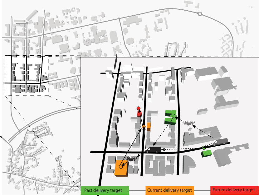
The first variant is on site drone dispatching and recovery, which means the drones are only dispatched and recovered at truck delivery nodes.
The second variant is en route drone dispatching and recovery, which as opposed to the first variant, allows for drones to be deployed and recovered at any location on the truck’s route. this variant may yield delivery efficiency gains over the on-site variant, but can at the same time be difficult or not always possible to perform. For instance, recovering a drone en route while the truck is riding on a highway may prove to be a tedious landing task.
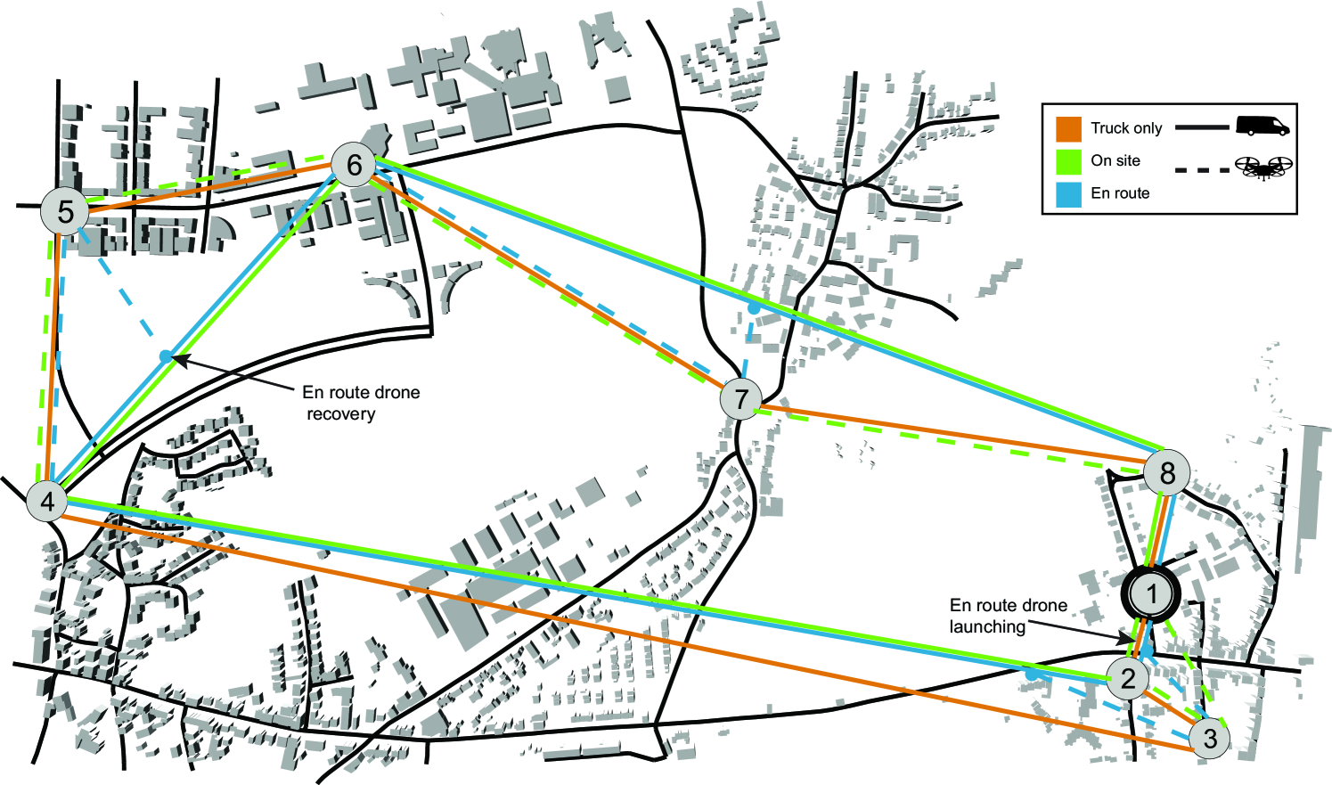
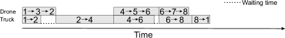
A basic job scheduling scheme is used to determine which delivery jobs are assigned to UAVs. A job gets allocated to a UAV if it is available and when the total estimated travel time for the job is smaller than the maximal allowed travel time for a drone. As a consequence, the job scheduling scheme does not disrupt the truck nodes order as it simply removes jobs from the truck’s list and assigns them to UAVs. The truck route is then constructed from the TSP-D solution analog to the TSP case. The generated solutions for the TSP, TSP-D and TSP-D with en route operations for our example scenario are illustrated in Fig. 2 and the associated Gantt charts are presented in Fig. 4.
To further mimic the logistics of delivery, execution parameters are used to control the waiting time for unloading the parcel at a delivery target once the agent - the truck or a drone - reaches it (further referred to as unloading time), as well as the take-off and landing duration of the drones. Speed limitations on the different road segments are respected. However, traffic signaling and congestion were not considered.
To fully leverage the potential of a heterogeneous delivery fleet requires a means to synchronize the agents. To this end, we defined a protocol to coordinate the interactions between the delivery truck and the UAVs, which is graphically featured in Fig. 3.
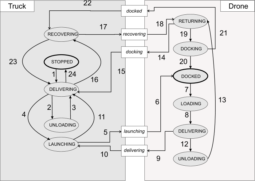
The delivery truck may deliberately wander between the STOPPED, DELIVERING, UNLOADING and LAUNCHING states.
For instance, upon reaching a delivery target, the truck switches to the UNLOADING state to unload the parcel and complete delivery.
The truck then switches back to the DELIVERING state after the unloading time is up and resumes delivery.
Nearly the same cycle is observed for the LAUNCHING state on the truck side with the only exception that there is no launch timer.
The delivery truck switches to the LAUNCHING state when it reaches a drone launch point and leaves it upon receiving a launch completion message from the launched UAV.
Entering and leaving the RECOVERING state is triggered by any UAV aiming to regroup with the delivery truck.
Before recovery, the truck slows down upon sensing a returning drone within a specific range and stops once the drone initiates recovery.
The drones get started in the DOCKED state, where they are docked to the truck and can, therefore, travel through the scenario without exerting any effort.
Upon receiving the launch message from the truck, they change in the LOADING mode, which they then leave for the DELIVERING state after the take-off timeout and notify the truck of launch completion.
Once they reach the delivery target, they switch to UNLOADING and continue in the RETURNING state once the unloading duration is spent.
While returning, the drones send a docking message to the truck as they get in docking range, causing the truck to stop for them to complete the docking maneuver after which they notify the truck of docking completion.
The en route delivery variant requires additional logic to keep the truck waiting in optimal launching or recovery range until the awaited events occur. In the on-site delivery variant, every truck delivery target is a potential drone launch or recovery point.


III-D Energy Consumption
To assess the power efficiency of the various delivery methods, the internal energy monitoring of LIMoSim is used. The mobility-related energy consumption tracking in LIMoSim is enabled through its hierarchical mobility model. The control inputs which are sent to the mobility’s locomotion layer are forwarded fo to a numerical energy model which computes the resulting consumption, based on the time interval during which these inputs are applied on the locomotion.
III-E Mobility Prediction
To further optimize the energy footprint of the drone delivery, we consider mobility prediction as it is one of the key enabling methods for anticipatory communication [22].
LIMoSim supports mobility prediction and allows the usage of a customized model. However it inherently provides an implementation of a hierarchical model which iteratively uses different prediction methods for forecasting successive future vehicle positions. At each prediction iteration, the method with the highest expected precision is used as illustrated in Fig. 5.
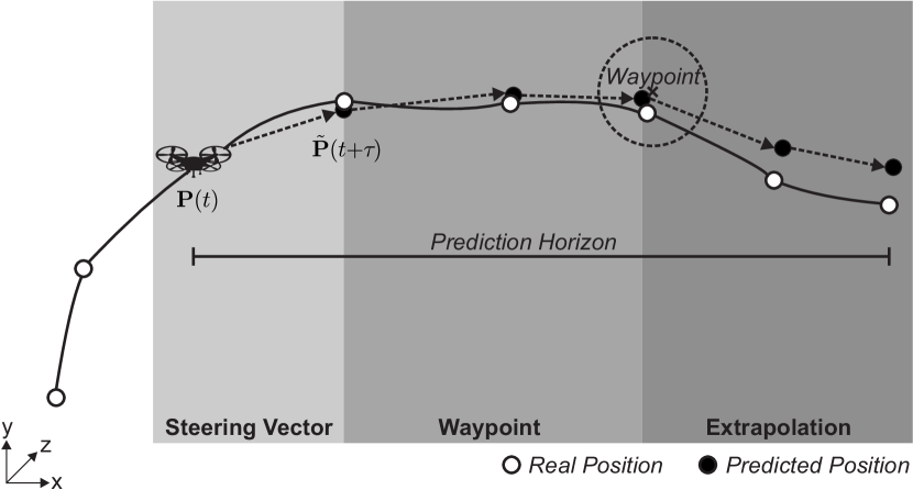
Specific extensions were made to the provided mobility prediction to leverage the routing information contained in the delivery route depending on the drone deployment scheme. These extensions are the following:
-
•
In on site mode, the next waypoint is the delivery target where regrouping shall take place
-
•
In en route mode, the next waypoint may be the next road intersection on the truck’s route or the next delivery target
IV Evaluation of the Delivery Approaches
In this section, we evaluate the performance of different delivery approaches. LTE and C-V2X (Mode 4) are applied for communications among delivery agents. The C-V2X implementation developed in [23] is used.
| Parameter | Value |
|---|---|
| Scenario size | 3000 m x 1500 m x 250 m |
| Maximum speed (Truck) | 13 |
| Maximum speed (UAV) | 16 |
The general simulation parameters common to all evaluations presented hereafter are listed in Tab. I
IV-A Enhancement of Delivery Performance
In the first analysis, three delivery modes are analyzed: truck only, on site and en route. In the drone assisted modes, we study the effects of increased drone usage. A summary of the relevant simulation parameters of this evaluation is given in Tab. II.
| Parameter | Value |
|---|---|
| Simulation duration | until delivery completion |
| Delivery sets | 50 |
| Deliveries per set | 15 |
| UAV count | {0, …, 15} |
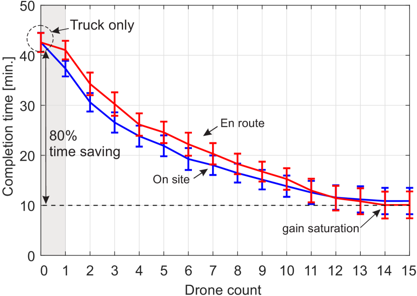
The evolution of the completion time with an increasing number of deliverer drones in Fig. 6 shows that the delivery tour can be completed faster with the usage of more drones. However, the time gain decreases after each drone increase until saturation is reached. It can also be observed that switching the operations mode from on site to en route adds a supplementary delay on the overall completion time. This is due to the simplicity of the drone delivery scheduling scheme used. As mentioned in Sec. III, the used scheme assigns deliveries to the drones while keeping the order of the remaining truck deliveries consistent with the truck only delivery schedule, therefore, causing the truck to stop more often in en route mode. It was shown that the en route approach yields better completion times than on site [5], however, a more complex job scheduling scheme must be used to further leverage the mobility advantage gained from drone support.
IV-B Energy Savings and Mobility Prediction
In the second evaluation, we focus on the energy consumption of the delivery modes which were used in the previous evaluation. Furthermore, we investigate the impact of mobility prediction on energy consumption in en route drone operations. This is motivated by the fact that drone recovery, which requires a regrouping point with the truck, does not occur at fixed points in en route mode as opposed to on site mode.
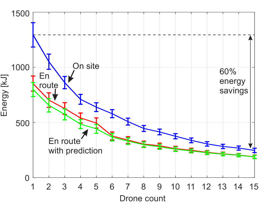
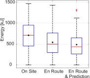
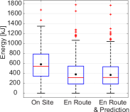
The mean energy consumption per UAV and grouped per delivery mode is shown in Fig. 7. An overall reduction of the energy footprint per drone is achieved when switching from on site to en route operations. Using more drones can also decrease the average energy consumption per drone up to 60 %. Mobility prediction allows for further energy sparing, but its effects become less perceptible as the drone count increases. This is presented more explicitly in Fig. 8 for the evaluated scenario. When using less than 6 drones, for instance 4, the sparing effects of mobility prediction are noticeable. The energy saved through mobility prediction becomes negligible from 6 drones upwards.
IV-C Investigating Network Communication Standard Usability
In the second evaluation, we monitor mission-critical network metrics for UAV-empowered PDP applications: the transmission latency and the Packet Delivery Ratio (PDR). The criticalness of these metrics, which is common among robotics applications, arises from the requirement of permanent monitoring of the UAVs. Therefore a reliable communication link between the delivery drones and the truck is needed.
To carry out our evaluation, standard Cooperative Awareness Messages are sent from the UAVs to the truck with a size of 190 Bytes every 100 ms [23]. These messages are likely safety-related, so the delay must be kept low and PDR should be high. Two communication technologies are applied: LTE and C-V2X. Common operating parameters values are used for the network configuration. An overview of the relevant simulation parameters to this evaluation is given in Tab. III.
| General | Parameter | Value |
| Simulation duration | 15 min | |
| Delivery sets | 50 | |
| Deliveries per set | 15 | |
| UAV count | { 1, 2, 3, 4, 5 } | |
| Channel model | DeterministicObstacleShadowing | |
| Packet Size | 190 Byte | |
| Inter Packet Interval | 100 ms | |
| C-V2X | Carrier frequency | 5.9 GHz |
| Bandwidth | 20 MHz | |
| (UE) | 23 dBm | |
| LTE | Carrier frequency | 2.1 GHz |
| Bandwidth | 20 MHz | |
| (UE) | 23 dBm | |
| (eNB) | 43 dBm |
: Maximum transmission power
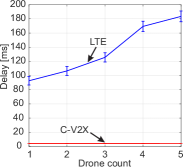
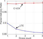
The statistical evaluation of the results is illustrated in Fig.9 and shows that C-V2X achieves a significant smaller latency than LTE. This stems from the applied C-V2X variant which implements Mode 4 behavior [23]. The channel is accessed directly, which gives the intra- User Equipment (UE) processing the dominant share on the overall delay. Whereas LTE transmissions are subject to resource scheduling mechanisms of the evolved Node B (eNB). The direct channel access of C-V2X however increases the collision probability with a growing number of UEs operating in the same interference region but does not hinder C-V2X from achieving a higher PDR than LTE with an increased number of drones as UEs. The LTE link quality is affected by the shadowing of buildings present in the scenario. These have an average height of 20 m.
IV-D The Influence of Building’s Height
In this last evaluation, we qualitatively investigate the influence of buildings height on the LTE communication link in the parcel delivery application context. The LTE simulation setup of the previous evaluation is used and the mean of the building’s height distribution in the scenario is varied.
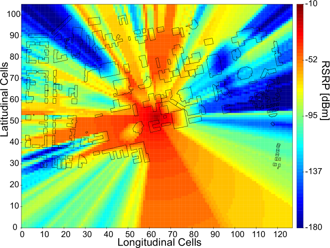
In order to model a deterministic and consistent interference behavior of the buildings the deterministic obstacle shadowing model provided in LIMoSim is used. An exemplary Reference Signal Received Power (RSRP) heatmap of the simulation scenario generated using this model is shown in Fig.10.
| Parameter | Value | |
|---|---|---|
| Simulation duration | 15 min | |
| Delivery sets | 50 | |
| Deliveries per set | 15 | |
| UAV count | { 1, 2, 3, 4, 5 } | |
| Channel model | DeterministicObstacleShadowing | |
| Mean building height | { 10 m, 20 m, 30 m} |
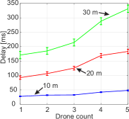
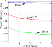
The increasing heights of buildings is shown in Fig. 11 to have a reinforcing effect on the network latency. This is due to the poor radio channel conditions associated with the shadowing caused by tall buildings. A similar effect befalls the PDR, which gets smaller with greater buildings height. Furthermore, having more drones access the channel increases the delay on a greater scale when surrounded by high buildings. The results show that the delay’s growth rate is higher when increasing the drone count at bigger buildings height. The PDR also degrades faster with an increasing number of UEs around high buildings.
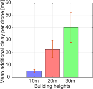
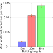
The penalties incurred by the increased drone usage on of the LTE-link are detailed further in Fig. 12. The average impact which adding one more drone to the scenario produces on the delay and PDR is analyzed for the different building heights. On average, going from 1 to 5 drones could incur 150 ms delay, and 50 additional packets out of 1000 may not be delivered correctly within an environment featuring buildings of an average height of 30 m. As opposed to an additional delay of about 20 ms and an extra loss of approximately 5 packets out of 1000 at an average building height of 10 m when increasing the drone count from 1 to 5.
V Conclusion
In this paper, we investigated the use of relying on UAVs to enhance logistics applications. We analyzed the feasibility of such an enhancement from the network perspective by comparing the performance of LTE and C-V2X for reliable communications among the delivery fleet. The evaluations were carried out using the system-level development platform for joint modeling of aerial and ground-based vehicular networks provided by the open simulation framework LIMoSim. It was shown that drone usage in parcel delivery can reduce the time taken to complete a delivery tour by up to 80%. Increased drone usage further reduces the completion time and the energy consumption per drone, however, speeding up the tour completion by increasing drone usage has limits. In a future work, the delivery performance could be enhanced further by using more efficient schemes to schedule delivery jobs for the drones. Such schemes could also consider energy efficiency as a scheduling criterion. An extension of the presented work could also account for more real-world interactions, such as traffic lights and congestion. Communication link deterioration around tall buildings still raises a challenge which could, however, be addressed by leveraging mobility prediction schemes, to forecast the channel conditions at future locations during the path planning procedure of the drone.
Acknowledgment
Part of the work on this paper has been supported by the German Federal Ministry of Education and Research (BMBF) in the projects LARUS (13N14133) and A-DRZ (13N14857) as well as the Deutsche Forschungsgemeinschaft (DFG) within the Collaborative Research Center SFB 876 “Providing Information by Resource-Constrained Analysis”, project B4.
References
- [1] J.-P. Aurambout, K. Gkoumas, and B. Ciuffo, “Last mile delivery by drones: An estimation of viable market potential and access to citizens across European cities,” European Transport Research Review, vol. 11, no. 1, p. 30, Jun 2019.
- [2] H. Menouar, I. Guvenc, K. Akkaya, A. S. Uluagac, A. Kadri, and A. Tuncer, “UAV-enabled intelligent transportation systems for the smart city: Applications and challenges,” IEEE Communications Magazine, vol. 55, no. 3, pp. 22–28, 2017.
- [3] B. Sliwa, T. Liebig, T. Vranken, M. Schreckenberg, and C. Wietfeld, “System-of-systems modeling, analysis and optimization of hybrid vehicular traffic,” in 2019 Annual IEEE International Systems Conference (SysCon), Orlando, Florida, USA, Apr. 2019.
- [4] J. G. Carlsson and S. Song, “Coordinated logistics with a truck and a drone,” Manage. Sci., vol. 64, no. 9, pp. 4052–4069, Sep. 2018.
- [5] M. Marinelli, L. Caggiani, M. Ottomanelli, and M. Dell’Orco, “En route truck–drone parcel delivery for optimal vehicle routing strategies,” IET Intelligent Transport Systems, 2018.
- [6] X. Lin, V. Yajnanarayana, S. D. Muruganathan, S. Gao, H. Asplund, H. Maattanen, M. Bergstrom, S. Euler, and Y. . E. Wang, “The sky is not the limit: LTE for unmanned aerial vehicles,” IEEE Communications Magazine, vol. 56, no. 4, pp. 204–210, Apr. 2018.
- [7] B. Li, Z. Fei, and Y. Zhang, “UAV communications for 5G and beyond: Recent advances and future trends,” IEEE Internet of Things Journal, vol. 6, no. 2, pp. 2241–2263, Apr. 2019.
- [8] N. Bui, M. Cesana, S. A. Hosseini, Q. Liao, I. Malanchini, and J. Widmer, “A survey of anticipatory mobile networking: Context-based classification, prediction methodologies, and optimization techniques,” in IEEE Communications Surveys and Tutorials, 2017.
- [9] Y. Zeng, Q. Wu, and R. Zhang, “Accessing from the sky: A tutorial on UAV communications for 5G and beyond,” arXiv e-prints, p. arXiv:1903.05289, Mar 2019.
- [10] C. C. Murray and G. A. Chu, “The flying sidekick traveling salesman problem: Optimization of drone-assisted parcel delivery,” Transportation Research Part C: Emerging Technologies, vol. 54, pp. 86–109, May 2015.
- [11] N. Agatz, P. Bouman, and M. Schmidt, “Optimization approaches for the traveling salesman problem with drone,” Transportation Science, Aug. 2018.
- [12] X. Wang, S. Poikonen, and ·. B. Golden, “The vehicle routing problem with drones: Several worst-case results,” Optimization Letters, vol. 11, pp. 679–697, 2017.
- [13] K. Dorling, J. Heinrichs, G. G. Messier, and S. Magierowski, “Vehicle routing problems for drone delivery,” IEEE Transactions on Systems, Man, and Cybernetics: Systems, vol. 47, no. 1, pp. 70–85, Jan. 2017.
- [14] B. Sliwa, J. Pillmann, F. Eckermann, L. Habel, M. Schreckenberg, and C. Wietfeld, “Lightweight joint simulation of vehicular mobility and communication with LIMoSim,” in IEEE Vehicular Networking Conference (VNC), Torino, Italy, Nov. 2017.
- [15] B. Sliwa, M. Patchou, and C. Wietfeld, “Lightweight simulation of hybrid aerial- and ground-based vehicular communication networks,” in 2019 IEEE 90th Vehicular Technology Conference (VTC-Fall), Honolulu, Hawaii, USA, Sep. 2019.
- [16] S. A. Hadiwardoyo, C. T. Calafate, J. Cano, Y. Ji, E. Hernández-Orallo, and P. Manzoni, “3D simulation modeling of UAV-to-car communications,” IEEE Access, vol. 7, pp. 8808–8823, 2019.
- [17] Y. Zhou, N. Cheng, N. Lu, and X. S. Shen, “Multi-UAV-aided networks: Aerial-ground cooperative vehicular networking architecture,” IEEE Vehicular Technology Magazine, vol. 10, no. 4, pp. 36–44, 2015.
- [18] B. Sliwa, D. Behnke, C. Ide, and C. Wietfeld, “B.A.T.Mobile: Leveraging mobility control knowledge for efficient routing in mobile robotic networks,” in IEEE GLOBECOM 2016 Workshop on Wireless Networking, Control and Positioning of Unmanned Autonomous Vehicles (Wi-UAV), Washington D.C., USA, Dec 2016.
- [19] H. Ghazzai, H. Menouar, and A. Kadri, “On the placement of UAV docking stations for future intelligent transportation systems,” in 2017 IEEE 85th Vehicular Technology Conference (VTC Spring), 2017, pp. 1–6.
- [20] T. Luukkonen, “Modelling and control of quadcopter,” Aalto University, Espoo, Tech. Rep., 2011.
- [21] C. Rego, D. Gamboa, F. Glover, and C. Osterman, “Traveling salesman problem heuristics: Leading methods, implementations and latest advances,” European Journal of Operational Research, vol. 211, pp. 427–441, 06 2011.
- [22] B. Sliwa, R. Falkenberg, T. Liebig, N. Piatkowski, and C. Wietfeld, “Boosting vehicle-to-cloud communication by machine learning-enabled context prediction,” IEEE Transactions on Intelligent Transportation Systems, Jul 2019.
- [23] F. Eckermann, M. Kahlert, and C. Wietfeld, “Performance analysis of C-V2X mode 4 communication introducing an open-source C-V2X simulator,” in 2019 IEEE 90th Vehicular Technology Conference (VTC-Fall), Honolulu, Hawaii, USA, Sep 2019.