CloudSat-inferred vertical structure of precipitation over the Antarctic continent
Abstract
Current global warming is causing significant changes in snowfall in polar regions, directly impacting the mass balance of the ice caps. The only water supply in Antarctica, precipitation, is poorly estimated from surface measurements. The onboard cloud-profiling radar of the CloudSat satellite provided the first real opportunity to estimate precipitation at continental scale. Based on CloudSat observations, we propose to explore the vertical structure of precipitation in Antarctica over the 2007-2010 period. A first division of this dataset following a topographical approach (continent versus peripheral regions, with a 2250 m topographical criterion) shows a high precipitation rate (275 mm.yr-1 at 1200 meters above ground level) with low relative seasonal variation (11) over the peripheral areas. Over the plateau, the precipitation rate is low (34 mm.yr-1 at 1200 m.a.g.l.) with a much larger relative seasonal variation (143). A second study that follows a geographical division highlights the average vertical structure of precipitation and temperature depending on the regions and their interactions with topography. In particular, over ice-shelves, we see a strong dependence of the distribution of precipitation on the sea-ice coverage. Finally, the relationship between precipitation and temperature is analyzed and compared with a simple analytical relationship. This study highlights that precipitation is largely dependent on the advection of air masses along the topographic slopes with an average vertical wind of 0.02 m.s-1. This provides new diagnostics to evaluate climate models with a three-dimensional approach of the atmospheric structure of precipitation.
JGR: Atmospheres
Sorbonne Université, École normale supérieure, PSL Research University, École polytechnique, CNRS, Laboratoire de Météorologie dynamique, LMD/IPSL, F-75005 Paris, France Development Centre for Weather Forecasting, Norwegian Meteorological Institute, Oslo, Norway Department of Atmospheric and Oceanic Sciences, University of Wisconsin-Madison, Madison, Wisconsin, USA
Florentin Lemonnierflorentin.lemonnier@lmd.jussieu.fr
Regridding of the CloudSat observations reveals the 3D structure of precipitation over Antarctica
Distributions vary substantially by type of region: ice sheet, peninsula or ice shelves
Precipitation rate - temperature relationship is explained by large-scale orographic precipitation
1 Introduction
Predicting the mass balance of ice sheets is a major challenge in the context of sea level rise. This surface mass balance depends on the relative magnitudes of precipitation versus sublimation/evaporation, meltwater run-off and blowing snow [Eisen \BOthers. (\APACyear2008)]. On an unfriendly continent for field observations, satellites are keys for observing precipitation. Based on these spatial remote sensing observations, recent studies observe an increasing ice loss in West Antarctica due to the acceleration of glacier and basal melting [Shepherd \BOthers. (\APACyear2018), Shepherd \BOthers. (\APACyear2012), Pritchard \BOthers. (\APACyear2012)]. This does not seem to be restricted to the West alone, and \citeArignot2019four shows that ice loss is more significant than its gain at the scale of the entire continent.
According to the climate models of the 5th Climate Model Intercomparison Project, precipitation over Antarctic would increase from 5.5 to 24.5 between 1986-2005 and 2080-2099. This increase would have a significant impact on sea level [Church \BOthers. (\APACyear2013)]. However, the present-day averaged Antarctic snowfall rates predicted by these models range from 158 to 354 mm.yr-1 while the first model-independent climatology of current Antarctic precipitation yields a value of 172 mm.yr-1 over the 2007 – 2010 period [Palerme \BOthers. (\APACyear2017)]. The latter value was recently re-evaluated at 160 mm/year [Palerme \BOthers. (\APACyear2019)] over the 2007 – 2010 period. It is worth noting that \citeAmilani2018cloudsat have also produced a climatology that also includes the Southern Ocean.
Apart from these surface precipitation estimates, the vertical structure of precipitation was poorly known until recently, but work by [Grazioli, Madeleine\BCBL \BOthers. (\APACyear2017)] compared vertical year-averaged profile of precipitation observed with ground radars with simulated snowfall profiles at Dumont d’Urville station. It showed surface rates in good agreement with climate models but significant biases in the vertical structure of precipitation. Using long periods of ground-based observations to characterize local snowfall events showed also a significant amount of virgas in precipitation events [Maahn \BOthers. (\APACyear2014), Durán-Alarcón \BOthers. (\APACyear2019)]. A poor representation of the vertical structure of precipitation reveals deficiencies of process representation in models including microphysical processes.
The thermal structure of the atmosphere over Antarctica, which is deeply involved in the origin of precipitation, is unique. The center of the continent being a cold pole, the structure of the Antarctic circumpolar flow is of baroclinical type. Low pressure systems are thus generated by horizontal temperature gradients in the troposphere and grow through baroclinic instabilities. Low pressure systems bring strong winds to the coastal areas when pressure gradients increase as polar lows over the ocean are moving southward and encounter areas of higher pressure, such as the semi-permanent continental anticyclone [Bromwich \BBA Parish (\APACyear1998), King \BBA Turner (\APACyear2007), Van de Berg \BOthers. (\APACyear2007)]. These winds are the moisture vectors that control large scale precipitation processes. Indeed, winds move air masses against the Antarctic continent and lead to encounters of moist and dry, hot and cold air masses, thereby creating ideal conditions for the formation of precipitation. Over the vertical axis, precipitation undergoes various changes before it reaches the ground. The origin of precipitation is described by cloud microphysics. Microphysical processes such as ice crystal nucleation are initiated in clouds, grow by diffusion at the expense of the supercooled droplets or by collision with other crystals, and fall to the ground [Findeisen \BOthers. (\APACyear2015), Dye \BOthers. (\APACyear1974)]. During its downfall, precipitation can reach drier air masses and sublimate, which can significantly reduce the precipitation rates. On the contrary, precipitation can reach saturated air masses, interact with potential clouds at lower altitude, aggregate and increase its mass flow. It is precisely all these processes and vertical evolution that define surface precipitation.
Precipitation in Antarctica is challenging to study, mostly due to geographic characteristics. Indeed, ground-based measurements are sparse and challenging in Antarctica and the size of this continent does not allow to cover and study the whole distribution, frequency and rate of precipitation. In coastal areas, it is influenced by synoptic conditions such as oceanic fronts [Bromwich (\APACyear1988)] and it is difficult to distinguish between precipitation and blowing snow caused by strong katabatic winds. Furthermore, re-sublimation processes of the precipitation in the lower layer of the atmosphere have been observed at Dumont d’Urville with a micro-rain radar, and result in a decrease in the precipitation rates at the surface [Grazioli, Madeleine\BCBL \BOthers. (\APACyear2017)]. At Princess Elisabeth and Dumont d’Urville, the study of \citeAduranalarcon2018VPR showed that in about a third of precipitation event cases, they are virgas that do not reach the surface. There can also be advection of very large amounts of moisture, providing a high annual precipitation contribution over the continent [Gorodetskaya \BOthers. (\APACyear2014)]. According to ground observations over peripheral areas and plateau, the ice crystals that are at the origin of the precipitation are thinner than 100 m and aggregate to constitute coarser particles [Lachlan-Cope \BOthers. (\APACyear2001), Lawson \BOthers. (\APACyear2006)]. A recent study shows that the occurrence of ice crystals at Dumont d’Urville is similar to that of aggregates at low altitude (500 m above the surface) [Grazioli, Genthon\BCBL \BOthers. (\APACyear2017)]. Over the continental plateau (2250 m), most of the precipitation is driven by a few fronts while the remaining annual precipitation rate is in the form of “Diamond Dust” (thin ice crystals) under clear-sky conditions [Bromwich (\APACyear1988), Fujita \BBA Abe (\APACyear2006), Turner \BOthers. (\APACyear2019)].
The first real opportunity to assess precipitation in polar regions from a spaceborne radar platform appeared with the cloud-profiling radar (CPR) on CloudSat satellite [Stephens \BBA Ellis (\APACyear2008), Liu \BOthers. (\APACyear2008)]. CloudSat provided day- and night-time solid precipitation observations from August 2006 to April 2011, which led to the first multi-year, model-independent climatology of Antarctic precipitation, with an average of 171 mm w.e year-1 over the Antarctic ice sheet, north of 82oS [Palerme \BOthers. (\APACyear2014)]. The first hundreds of meters over the surface are contaminated by radar wave reflections from the surface, which is called ground-clutter. A study of \citeAmaahn2014 investigated whether a thinner ground clutter layer could increase the quality of the precipitation measured at Princess Elisabeth, but the data are really usable only from 1200 m.a.g.l. The climatology of \citeApalerme2014much is based on the 2C-SNOW-PROFILE product [Wood (\APACyear2011)],, which provides, on average, an uncertainty on single snowfall retrievals ranging between 1.5 and 2.5 times the snowfall rate [Wood (\APACyear2011), Palerme \BOthers. (\APACyear2014)]. However, recent studies based on comparisons with ground-based radars reassessed this range of uncertainty for a few snowfall events at two Antarctic stations [Lemonnier \BOthers. (\APACyear2019), Souverijns \BOthers. (\APACyear2018)], and provided uncertainties ranging from 13 to 22 for the CloudSat snowfall observations. \citeApalerme2018groundclutter have identified some CloudSat observations likely contaminated by the ground clutter over mountainous areas, and have produced a new climatology with a mean snowfall rate of 160 mm.yr-1.
In this study, we computed the first 3-D multi-year climatology of Antarctic precipitation north of 82∘S from spaceborne remote sensing observations (section 2). As a first step, we characterize the general horizontal and vertical structures of the precipitation averaged in time over the continent (section 3). Then, a comparison between CloudSat snowfall retrievals and concurrent 3D meteorological parameters obtained from the European Center for Medium-Range Weather Forecast (ECMWF) operational weather analysis at each vertical level is conducted in section 4. This allows us to determine which physical or dynamical process predominates on the high continental plateau and on the peripheral areas. At last, we propose a new way of evaluating modelled precipitation using this new dataset, and especially its vertical structure, in atmospheric models such as global GCMs or Antarctic regional models (section 5).
2 Data and method
Here, the climatology produced by \citeApalerme2018groundclutter is extended to all vertical levels up to 10000 m. The first 4 bins above the surface are excluded due to potential ground clutter contamination [Wood (\APACyear2011)]. We used the fifth release of 2C-SNOW-PROFILE CloudSat product [Wood (\APACyear2011), Wood \BOthers. (\APACyear2014)] that gives an estimate of the liquid-equivalent snowfall rate and its Snow Retrieval Statue (SRS) which indicates if some errors occurred in the retrieval process. The retrieval of this product is based on a relationship between reflectivity and snowfall that takes into account a priori estimates of snow particle size distribution and microphysical and scattering properties at each vertical bin [Rodgers (\APACyear2000)]. Then this product is averaged within each cell of a grid over the Antarctic continent from about 1200 m.a.g.l. (meters above ground level) up to 10000 m.a.g.l. (5th to 45th bins above the surface) with a 240 m vertical resolution. The same extraction process is applied to the associated ECMWF-AUX operational weather analysis temperatures, humidities and pressures in order to obtain a climatology based on the same sampling.
The low temporal sampling of CloudSat is a source of uncertainty. Following \citeAsouverijns2018cloudsatgrid, this new CloudSat climatology is processed over a grid of 1∘ of latitude by 2∘ of longitude. This grid is able to accurately represent a snowfall climatology and is the best balance between satellite omissions and commissions, according to data from three ground radars.
2C-SNOW-PROFILE provides a snowfall uncertainty between 1.5 and 2.5 times the solid precipitation rate for a single measurement. The average over the whole continent over the 2007–2010 period reduces this uncertainty but some uncertainty remains due to systematic errors in algorithm assumptions that are difficult to assess [Palerme \BOthers. (\APACyear2014)]. \citeAlemonnier2018evaluation reassessed this range of uncertainties by a short-time (a few seconds) and short-spatial scale comparison of CloudSat measurements with 24 GHz Micro Rain ground radars at different locations in East Antarctica (a coastal and a high altitude station) with two different kinds of weather conditions, leading to new values of [-13, +22] and providing confidence over the full height of the CloudSat retrievals.
The temperature associated with each precipitation profile is obtained from ECMWF-AUX operational weather analysis. The ECMWF-AUX data set is an intermediate product that contains the set of ECMWF state variable data interpolated to each CloudSat cloud profiling radar bin. Besides the snowfall rate climatology computed on a continental grid at each vertical level of the satellite, the pre-gridded dataset of the 2C-SNOW-PROFILE product (snowfall retrieval and geolocation fields) as well as the ECMWF-AUX product were extracted in order to evaluate the relationship between precipitation rates and temperatures (see section 4).
3 General structure of Antarctic precipitation
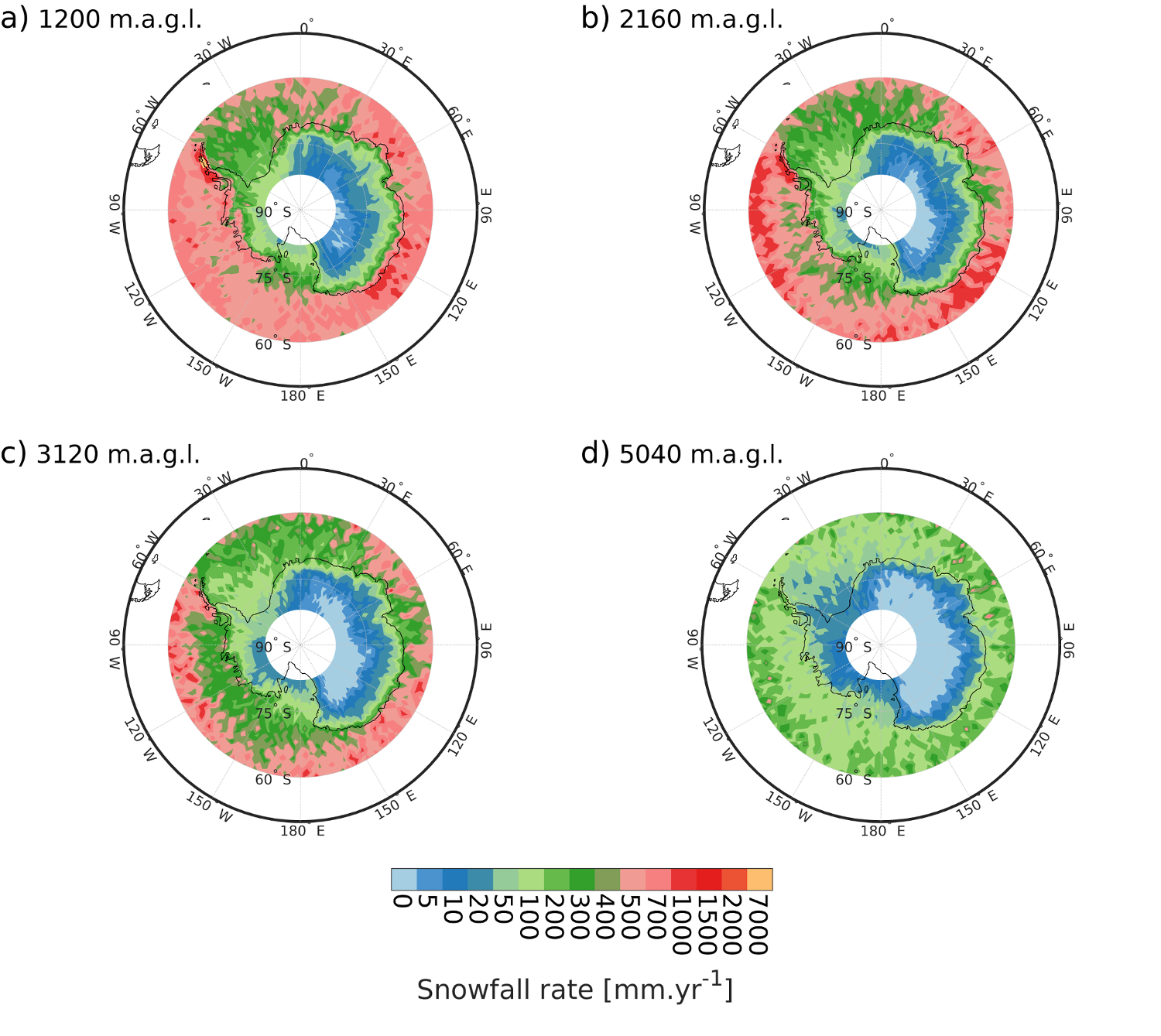
Figure 1 shows precipitation maps over Antarctica at four different CloudSat vertical levels. As highlighted in previous studies [Palerme \BOthers. (\APACyear2014), Milani \BOthers. (\APACyear2018)], there is a dichotomy in precipitation rate between the high plateau of the continent where the snowfall rate is excessively low and the coastal areas. It is also important to note extremely high precipitation rates located west of the Antarctic peninsula and over mount Vinson. This is due to high orography and moisture flux from the Southern Ocean, producing more clouds and precipitation [Nicolas \BBA Bromwich (\APACyear2011)]. Precipitation over the ice-shelves appears to be very low. According to the study of \citeAknuth2010influence carried out over the Ross ice-shelf, it even appears that the blowing and drifting snows prevails over the accumulation of precipitation. Thus, precipitation is regionally very variable in Antarctica. Figure 1 shows that precipitation decreases with altitude over the continent, which is not always the case over the ocean. Indeed, over all oceanic regions south of 60∘S except the eastern part of the peninsula and above the ice-shelves, the precipitation rate increases between the 1200 m.a.g.l. (fig. 1.a) and 2160 m.a.g.l. (fig. 1.b) vertical bins before decreasing further at altitude (fig. 1.c and 1.d). This could be explained by a local formation of snow in regions of shallow convection, as highlighted by \citeAkulie2016shallow and \citeAmilani2018cloudsat, who looked at the differences between the 3rd and the 6th vertical bins.
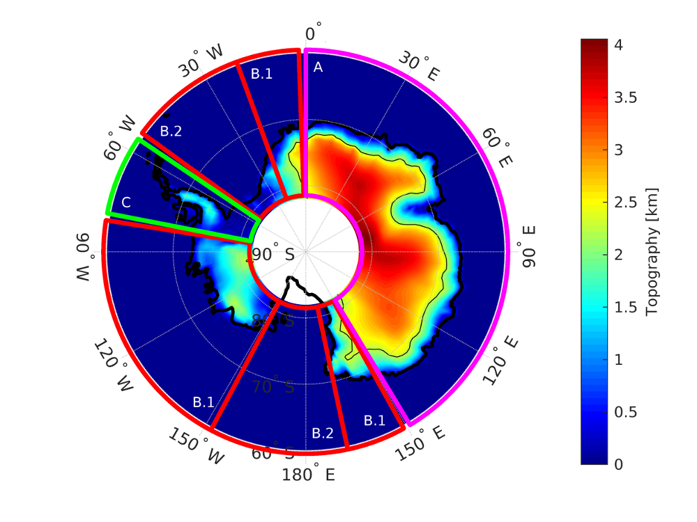
The thin black solid line in fig. 2 delineates regions that are 2250 m above sea-level. This altitude separates peripheral areas where precipitation is mostly controlled by large scale oceanic fronts, from the plateau where snowfall is rare and depends on a few events which are large enough to bring moisture onto the Antarctic plateau.
In order to have a better understanding of the horizontal and vertical structures of snowfall, the Antarctic continent is also divided into several geographic regions. Figure 2 presents these different regions for the following geographic areas :
-
•
A The first studied area is the East Antarctic, located between 0∘ and 150∘ of longitude. This area is defined mostly as an homogeneous ice-sheet with a huge plateau at an altitude of 3000 m above sea level.
-
•
B The second studied area is the West Antarctic, lower in altitude than the East part of the continent. This region has been subdivided in two parts, one comprising mountain ranges including the mount Vinson (B1) and the other part comprising the massive Ross and Ronne-Filchner ice-shelves (B2).
-
•
C The third region of interest is the peninsula, which is very mountainous and where precipitation is exceptionally high.
3.1 From coasts to high continental plateau
By dividing Antarctica according to topographical information (2250 m in surface elevation, see \citeApalerme2014much), we distinguish two different types of climate. The peripheral areas includes the Peninsula (surface elevation 2250 m), West Antarctica and eastern coasts. The plateau (surface elevation 2250 m) includes essentially East Antarctica. Following \citeApalerme2017evaluation, fig. 3 summarizes the seasonal evolution of the precipitation over the Antarctic continent. The seasonal variability of snowfall across the Antarctic continent is mainly influenced by snowfall in peripheral regions, with the periphery of the continent receiving the vast majority of precipitation [Bromwich (\APACyear1988), Genthon \BOthers. (\APACyear2009)]. This figure corresponds to the 5th CloudSat vertical bin at about 1200 m.a.g.l. Over the Antarctic continent and especially over peripheral areas (altitude 2250 m), the maximum snowfall rate is observed in March-April-May (MAM) then decreases until December-January-February (DJF) where the snowfall rate is minimum. Over the plateau, this variability differs with a maximum in precipitation rate over the DJF period and a minimum in June-July-August (JJA). Error bars represent the CPR measurement uncertainties given by \citeAlemonnier2018evaluation, obtained by a comparison of four precipitation events with ground instruments at two different locations. The seasonal evolution of precipitation has been studied for the other vertical levels of the product, and no difference in seasonal variability from one level to another is observed. As already mentioned by \citeApalerme2017evaluation, the seasonal evolution of mean precipitation in Antarctica is in accordance with ERA-Interim and climate models for the peripheral regions. This is not the case for precipitation above the plateau. A more recent study by \citeAlenaerts2018signature focusing on ground accumulation presents similar results, although it focuses on surface snow accumulation, where other processes such as surface sublimation or blowing snow are at work.
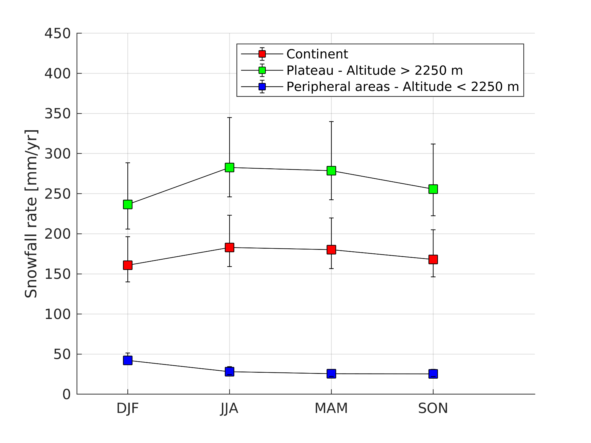
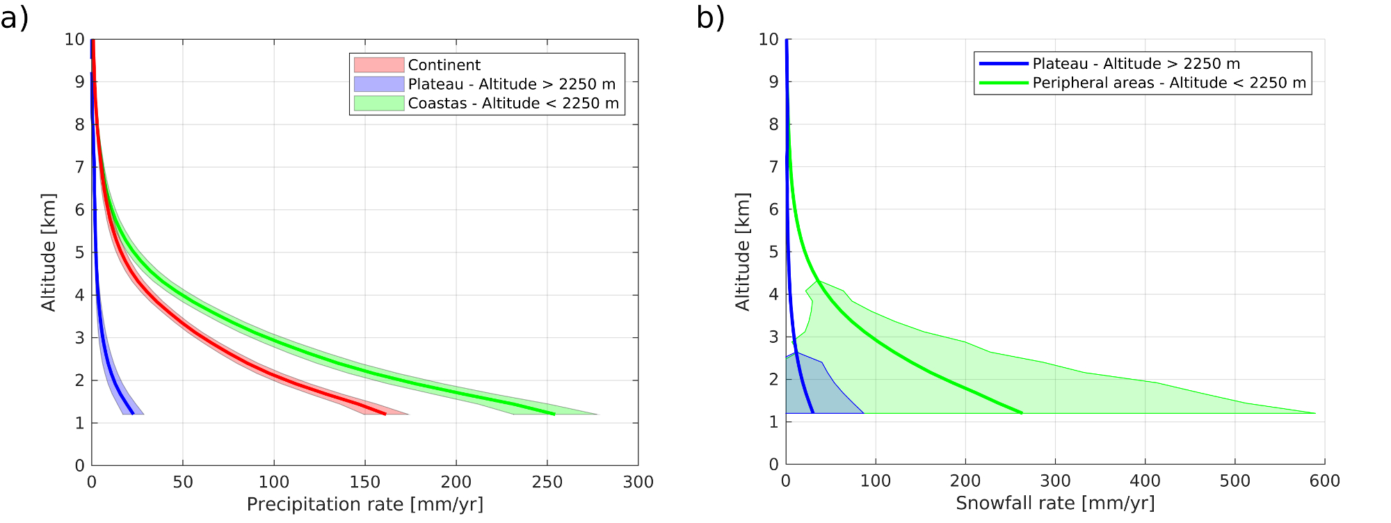
Fig. 4 shows another aspect of the vertical structure of precipitation in Antarctica above the ground clutter layer represented by annual average precipitation profiles. Each profile is averaged over the 2007–2010 period, then area-averaged. The standard deviation on fig. 4.a is calculated from the time dimension (in months) and on fig. 4.b it is calculated from the gridded spatial dimension. As observed in this figure, monthly temporal variability is low over the Antarctic continent. We note that the time standard deviation is continuous over the entire precipitation profile. The spatial variability is important, whether on the plateau or over peripheral areas. This spatial standard deviation decreases very rapidly with altitude. Thus, the precipitation rates recorded at high altitudes appear to be regionally homogeneous. Precipitation consistently increases from 7000 m in altitude until 1200 m, reaching a rate of approximately 160 mm.yr-1. At this altitude, the precipitation gradient should become negative and the profile should reach a maximum in precipitation before inverting in the lowest layers over the peripheral areas (in green), according to several studies [Grazioli, Madeleine\BCBL \BOthers. (\APACyear2017), Durán-Alarcón \BOthers. (\APACyear2019)]. The blue line presents the profile over the plateau. It is characterized by a very small amount of precipitation all along the profile and a relatively large dispersion : 30 mm.yr-1 with a -value of almost 50 in the lowest bin. It suggests a high variability over the plateau. In comparison with the plateau, the green line presents the peripheral profile of precipitation, with higher precipitation values and a lower variability. Fig. 4 confirms that precipitation in Antarctica mostly occurs over the coasts. As highlighted by \citeAgrazioli2017katabatic, there is an inversion of the precipitation profile in the lowest layers ( 1000 m) over the Dumont d’Urville station due to snow sublimation by katabatic winds. However, CloudSat does not see this low-level sublimation inversion layer because of ground clutter [Lemonnier \BOthers. (\APACyear2019), Palerme \BOthers. (\APACyear2019)].
3.2 From geographical areas
The re-gridded precipitation dataset is used to evaluate seasonal variabilities as well as vertical variabilities. This study also takes into account different regions of interest with the aim of providing useful diagnostics for climate models. Precipitation in each geographical region is longitudinally averaged at each CloudSat vertical bin for the entire period of observation. The same computation is applied to the atmospheric temperature from ECMWF operational weather analysis and digital elevation model. The results are presented in the first column of Fig. 5. The baroclinic structure of temperature, with the isotherms bending down towards the pole, is visible on each latitudinally averaged regions of fig. 5. Then we present in the second column the averaged snowfall rate at the fifth CloudSat level (at 1200 m.a.g.l., same studied altitude above ground level than \citeApalerme2014much) in blue and its associated temperature in red over both the continent and the oceans (up to 60∘). The filled areas around the means in blue and red are the corresponding -standard deviations of the precipitation rate and temperature. The standard deviations are calculated over the spatial dimension for each region of interest.
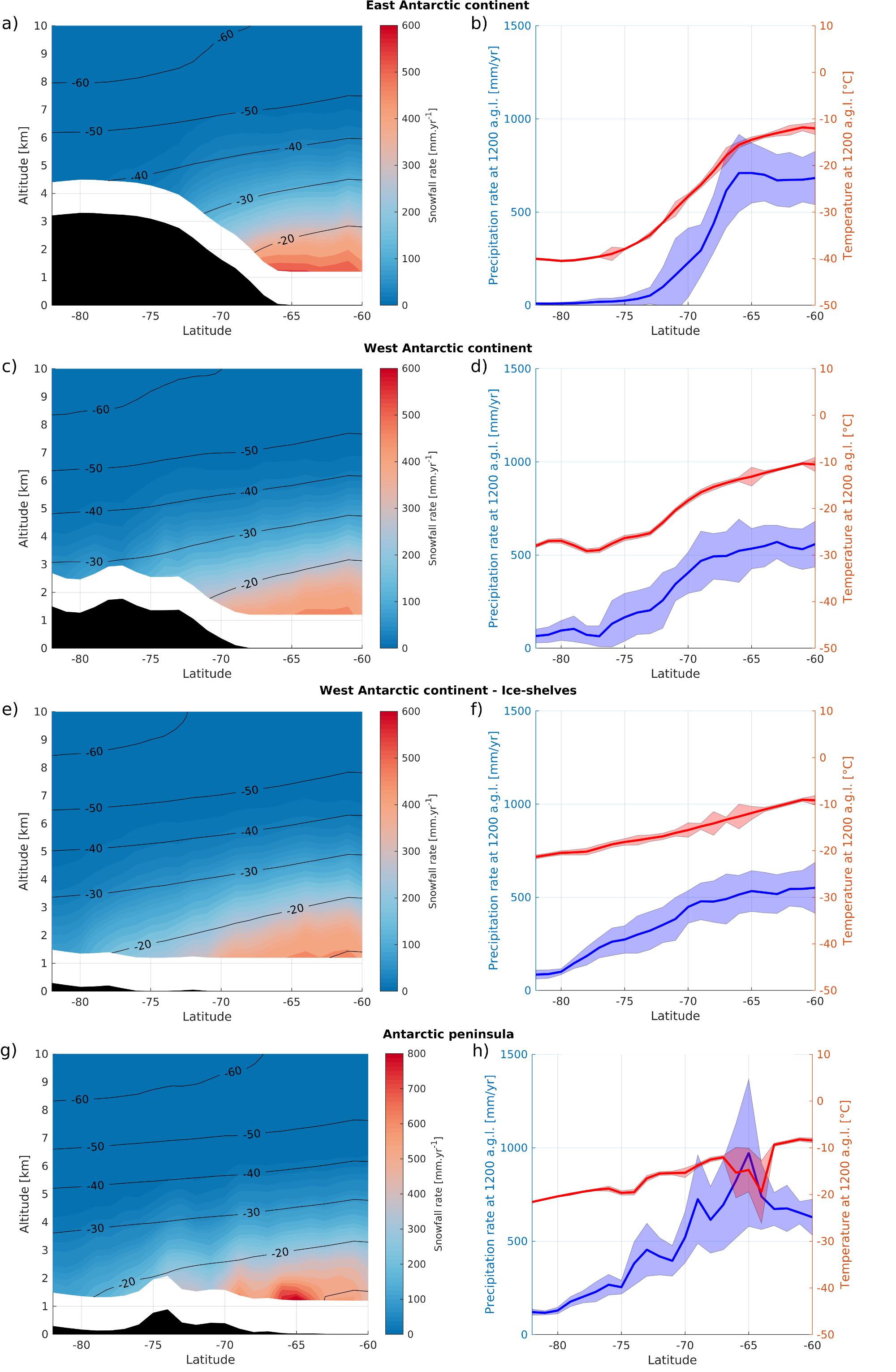
Fig. 5.a represents precipitation structure over East Antarctica, the most homogeneous region of the Southern continent, and highlights an obstacle to the progression of precipitation flows with topography. The iso-precipitation rates are following isotherms over the ocean but are no longer parallel over the continent with a faster decrease in precipitation isolines. The precipitation rate drops from 600 mm.yr-1 to less than 10 mm.yr-1 along 10 degrees of latitude and 3000 meters of altitude difference. Fig. 5.b, which only considers retrievals at the first available bin over the surface, shows with more accuracy this latitudinal evolution. The precipitation rate over the plateau is very low and its associated standard deviation is relatively important (almost 100). From 75∘S and northward, at the edge of the plateau, precipitation rate increases quickly before reaching a maximum value of 600 mm.yr-1 over the ocean at latitude 66∘S. The temperature along the slope follows a similar evolution. Over the Southern Ocean, precipitation and temperature stabilize and reveal a more homogeneous oceanic climate.
Regarding the western part of the continent, there are some similarities with the eastern continent, such as the low precipitation rate on the plateau on fig. 5.c. The average precipitation rate at low altitude is lower than in the East, at 500 mm.yr-1. The transition from continental to oceanic precipitation rates seems to be more gradual. The precipitation rate decreases from 500 mm.yr-1 to about 150 mm.yr-1 at an average elevation of 1500 m without stabilizing above the plateau, probably due to local orographic effects that characterize this region. The sea-ice cover is vast in this region of Antarctica, although the seasonal variability of its area is high, this precipitation pattern may be a persistent signal of winter precipitation behaviour. Indeed, surface humidity fluxes can be reduced in winter by the sea ice cover, preventing the atmosphere from collecting moisture by evaporation. On fig. 5.d, similarly to the eastern part of the continent, precipitation rate and temperature are increasing along the slope to the ocean. Gradient changes in the precipitation curve at 73∘S and 78∘S are caused by topography.
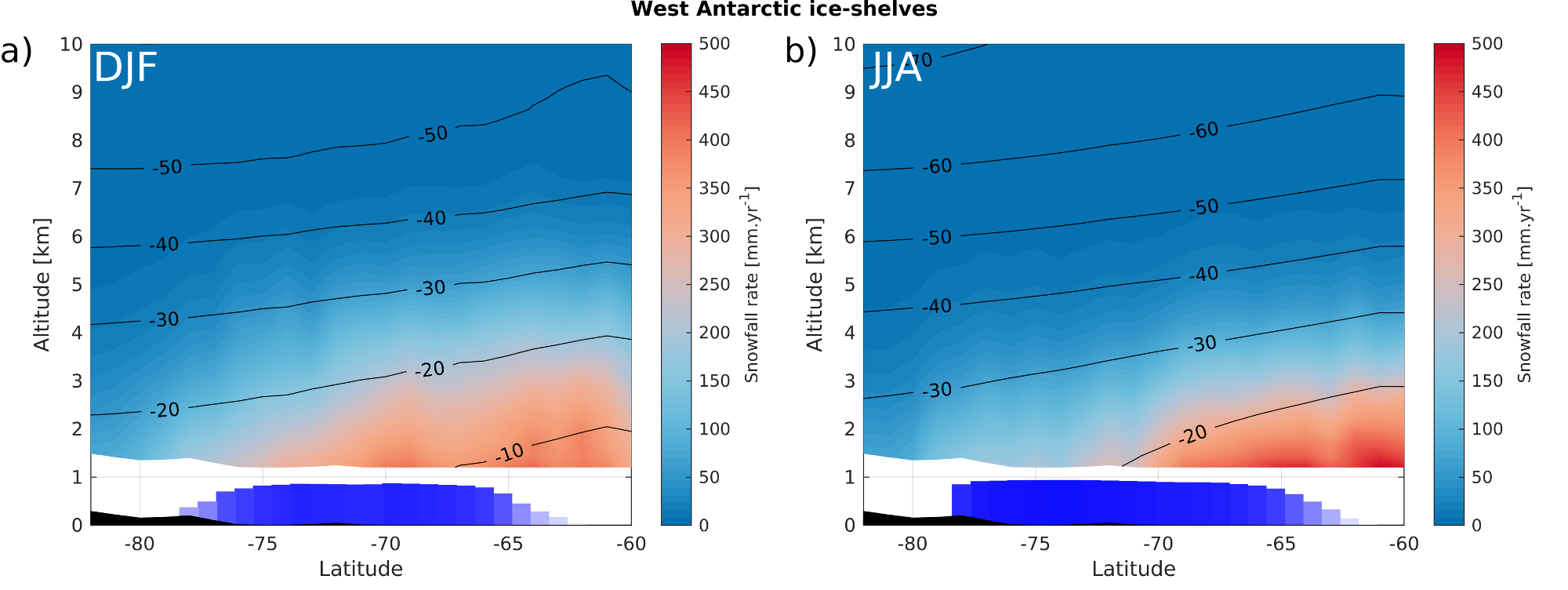
Over the western ice-shelves on fig. 5.e, precipitation rate ranges from 100 to 500 mm.yr-1 at the first level. This could be due to a lack of moisture input to the atmosphere due to the sea ice cover and ice-shelves. Indeed, there is a slight correlation between sea ice concentration and low level clouds [Schweiger \BOthers. (\APACyear2008)]. When crossing the ice-shelves at 75∘S, the precipitation increases quickly with latitude and altitude. Fig. 6 presents the seasonal variation in precipitation over this region. The reanalyses of ERA-Interim are used to present sea-ice cover fraction over the 2007–2010 period, which is shown in this figure using blue bars and ranging from 0 to 1 (0 to 100 of sea ice cover fraction). In winter (fig. 6.b), the almost complete sea ice coverage shows a maximum precipitation at 60∘S which decreases rapidly above the ice-shelf following isotherms. In summer (fig. 6.a), the average sea ice coverage is less extensive but still over 80. Also, there is higher averaged temperatures. Therefore, there is stronger precipitation rates closer to the coasts, with values ranging from 300 to 500 mm.yr-1 in the vicinity of the coasts at 75∘S. Fig. 5.f shows a slow evolution of precipitation on ice-shelf with a very low standard deviation (less than 25 the value itself), while the temperature decreases linearly with latitude.
The peninsula is a particular region of interest, with a mountain ridge extending across the circumpolar atmospheric circulation. Over this region, precipitation is mostly driven by orogenic effects. Fig. 5.h shows a high precipitation rate with a large standard deviation. The maximum snowfall rate is observed at the end of the peninsula with very high rates reaching 1000 mm.yr-1 at 65∘S as seen on fig. 5.g. At 65∘S the precipitation reaches its maximum and there is an abrupt decrease in temperature. At this latitude, the topographic gradient of the peninsula is very intense. Over the peninsula, from 64∘S to 74∘S, precipitation rate is high and strongly affected by topography. It ranges from 500 to 700 mm.yr-1 before decreasing from 75∘S to 82∘S with precipitation rates lower than 200 mm.yr-1. The topographic obstacle at 75∘S with an average elevation of nearly 1000 m, but locally reaching 2500 m, results in two precipitation regimes, intense over the peninsula and low on the continental side. To better understand these results, we have performed a high-resolution climatology (see fig. 7) of 0.1∘ in longitude by 0.1∘ in latitude on the first available level of CloudSat by averaging measured precipitations rates and corresponding temperatures in each cell as we did with a 2∘ in longitude by 1∘ in latitude grid for the whole continent (see section 2). This figure clearly shows the effect of topography on precipitation and temperature fields. Both temperature and precipitation are higher west of the peninsula, with very high precipitation rates reaching 1000 mm.yr-1 observed along the west coast of the peninsula. On the east side, the temperature is lower due to the Larsen C ice-shelf. As seen in fig. 7.b, the temperature above the peninsula is much lower than above the ocean with values ranging from -15 to -25∘C. This high-resolution view provides a better understanding of the precipitation and temperature variations observed in fig. 5.g and 5.h. Indeed, they show an average structure of warmer and wetter regions in the west of the peninsula with colder and drier regions in the east of the peninsula, thus increasing the variability of temperature and precipitation.
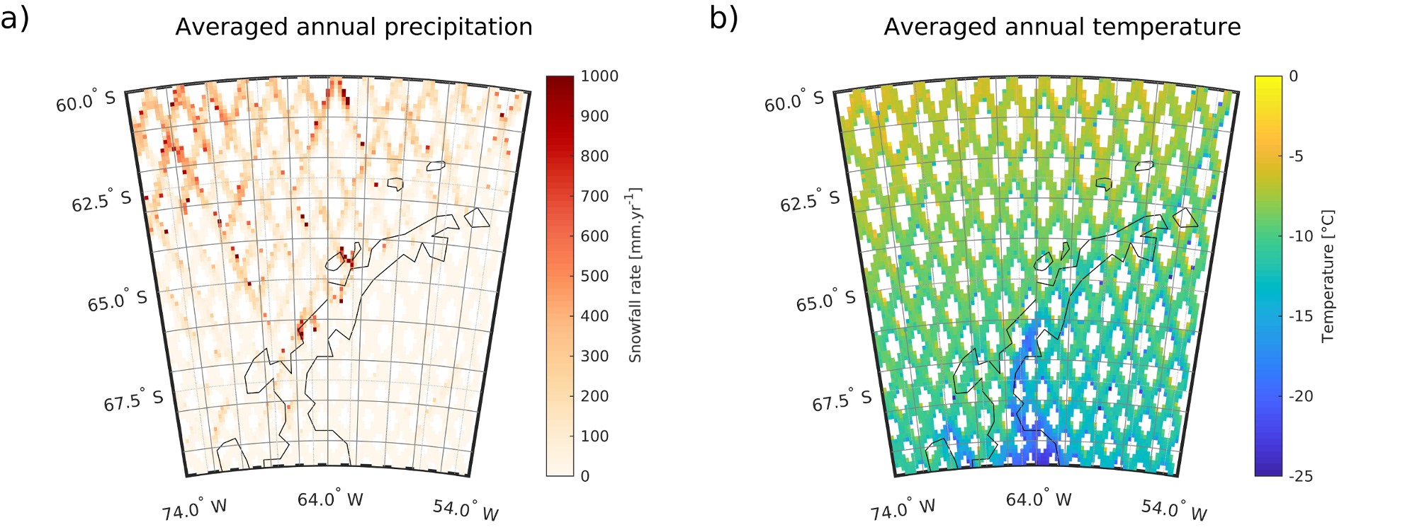
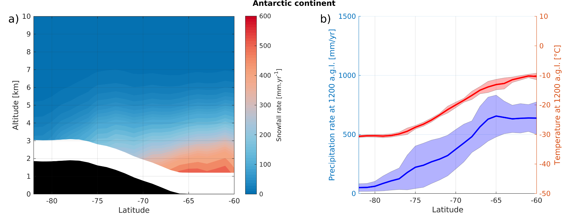
Fig. 8.a summarizes the precipitation structure over the entire continent. It clearly shows that precipitation over ocean follows isotherms and thus evolves with temperature. Then precipitation isolines depart from isotherms over the topographic slope : precipitation rates are drastically decreasing when confronting the plateau. Indeed, the air masses rising along the topographical slope are now far from oceanic moisture sources, thus explaining the divergence of isotherms and precipitation contours. The average evolution of the topographical slope of Antarctica rises from sea level to 2000 metres above sea level from 66∘S to 78∘S. This topographical evolution is associated with an evolution of precipitation from 700 mm.yr-1 to 150 mm.yr-1. On the plateau, precipitation can reach values as low as 10 mm.yr-1. Fig. 8.b shows the evolution of the zonal mean precipitation rate at the fifth CloudSat bin. Over the plateau, precipitation rate is low but its standard deviation is relatively high, indicating that precipitation is not homogeneous, but brought by local events that transport moisture from the Southern Ocean. Along the topographic slope between coasts and plateau, precipitation and temperature are increasing, then precipitation reaches a maximum of 600 mm.yr-1 at 66∘S.
4 Precipitation distribution over the Antarctic continent
In order to have a better representation of the precipitation over the ice-cap and to develop a new diagnostic tool for models, we looked at the distribution of the 2C-SNOW-PROFILE and ECMWF-AUX products raw data over the entire 3D dataset south of 60∘S. To do so, we have arranged these points in temperature bins of linear size and precipitation rate bins of logarithmic size. The study of the general structure of precipitation performed in section 3 showed that the main climatological differences are between the oceanic border regions and the high plateau. In this section we therefore keep distinguishing the peripheral precipitation from the precipitation over the plateau.
4.1 Evolution of precipitation distributions with altitude
Each vertical CloudSat level above the surface has been studied separately. Fig. 9 presents histograms of the distribution of precipitation rate observations evolving with altitude. In both areas, the precipitation distribution of the first level is truncated at 0.01 mm/hr, while for the other levels, there is no truncation. However, we observe precipitation rates below 0.01 mm/hr in the 2C-SNOW-PROFILE product. The SnowRetrievalStatus values for these measurements are greater than 3, indicating that an error in the retrieval process could occur. It would therefore seem that ground clutter, in addition to generating excessive precipitation rates, does not allow sufficient confidence to be placed in small rates of near-surface precipitation. It is worth noting that we calculated the average precipitation rate at the second available level of CloudSat (at 1440 m.a.g.l.), by taking into account and by excluding the points recorded under 0.01 mm/hr to make sure that the ground clutter does not affect the averaged precipitation rate. This has no impact on the averaged snowfall rate at 1440 m.a.g.l. Doing so, we indeed verified that the missing observations do not affect the average precipitation rate at 1200 m.a.g.l., neither for peripheral regions nor on the plateau.
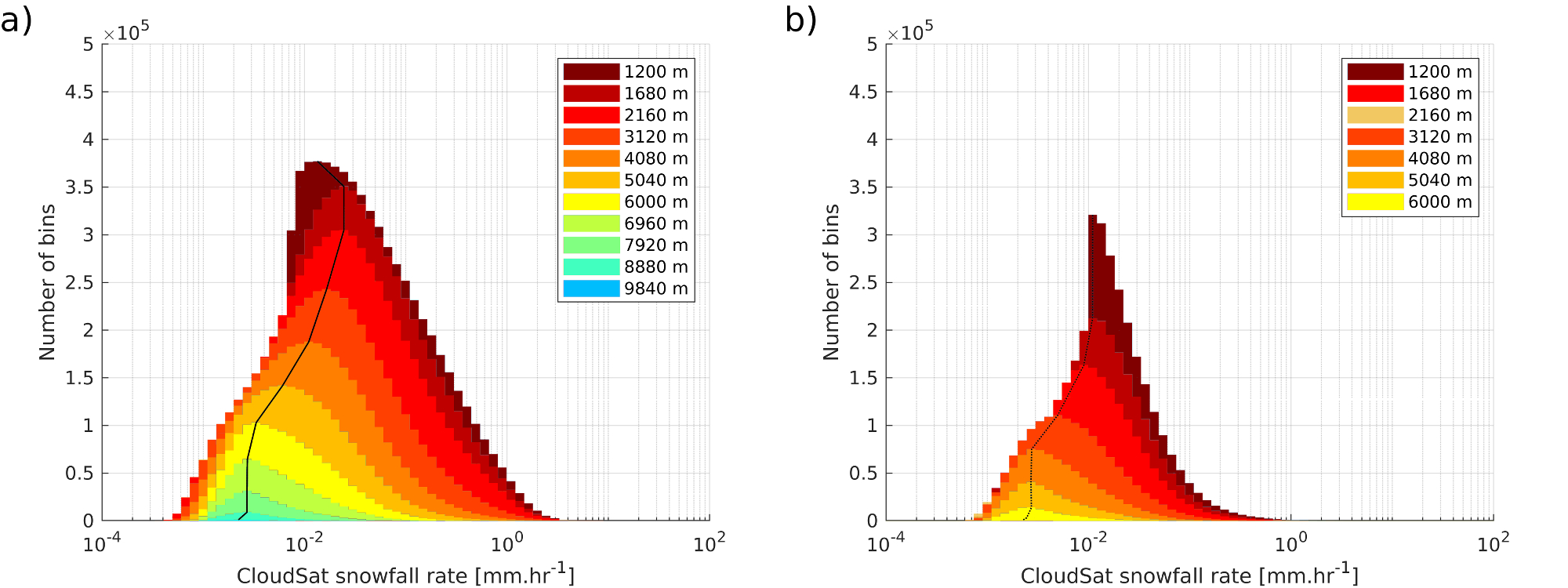
We observe that the evolution of the number of observations and measured precipitation rates as a function of altitude above the coasts and plateau is similar, except for the first level under investigation. For coasts, distribution maxima at 1680 m.a.g.l. (7th bin) and 2160 m.a.g.l. (9th bin) do not vary in precipitation rate (0.0221 mm.hr-1) but decrease from 14 in records numbers. It then reaches 0.0148 mm.hr-1 at 3120 m.a.g.l. (13th bin), 0.0099 mm.hr-1 at 4080 m.a.g.l. (17th bin) and 0.0055 mm.hr-1 at 5040 m.a.g.l. (21th bin). Along these levels, there appears to be a consistency in the logarithmic decay of the peaks. Above 6000 m.a.g.l., the maximum precipitation rate stabilizes around a value of 0.0030 mm.hr-1. Over the plateau, the position of the maximum in the lower vertical bins is at a lower precipitation rate than on the coasts. Apart from the truncated level, there is a decrease from 0.0099 mm.hr-1 to 0.0081 mm.hr-1 between 1680 m.a.g.l. (7th bin) and 2160 m.a.g.l. (9th bin). A thousand meters above at 4080 m.a.g.l. (17th bin) the peak is located at 0.0030 mm.hr-1. Finally, at higher altitudes, the maximum remains in the same precipitation rate, centered on 0.0025 mm.hr-1. For each region, the positions of the maxima at all altitudes are listed in Appendix A.
4.2 Precipitation at saturation by forced lifting
CloudSat observations are also presented on scatterplots in fig. 10 at different altitudes above ground level. The colorbar indicates the relative number of observations for a given precipitation rate and temperature. Over the peripheral regions, there is a significant spread both in precipitation rate and temperature. Over the plateau, the spread in precipitation is smaller and the distribution is centered at lower temperatures. In both regions, there seems to be a relationship between precipitation and temperature, and the spread in precipitation rate decreases when altitude increases.
To further understand these distributions, we can derive an analytical relationship between precipitation and temperature by assuming that precipitation over the Antarctic ice cap is mostly controlled by the topographic lifting of oceanic air parcels that are initially close to saturation. We first assume that all the horizontal motion is converted into vertical motion. Then, assuming a mean horizontal wind velocity over a given slope, we can deduce the vertical speed of the oceanic air parcels. Then, this vertical wind speed can be used to lift air parcels along the moist adiabatic lapse rate. At each level, all the water vapor entering the parcel will be in excess of saturation and said to be equal to the precipitation mass flux. By integrating over the vertical direction, the resulting precipitation rate can be written as:
| (1) |
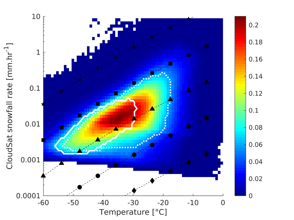
where is the vertical wind speed, is the water density and is the air density, is the latent heat of sublimation, is the humidity at saturation, is the specific gas constant for wet air and is the moist adiabatic lapse rate. The demonstration is in the B. This integral equation is resolved by using 240m corresponding to the CloudSat bin vertical dimensions. The precipitation expressed by equation 1 is given in water equivalent mm.hr-1. It is represented by the black curves with markers on fig. 10. The values used for are 0.0001 m.s-1, 0.001 m.s-1, 0.01 m.s-1, 0.1 m.s-1 and 1 m.s-1. They are respectively represented in fig. 10 by black dashed lines with diamond, circle, triangle, square and star markers. The rows are corresponding to CloudSat vertical bins above the surface, at respectively 1200, 2160, 3120 and 5040 m.a.g.l. which are corresponding to the 5th, 9th, 13th and 21th vertical bins above the surface. The white solid line limit defining the standard deviation of the population distribution provides additional information on precipitation. In both cases, the spread in precipitation is greater when T increases and follows the trend with the triangles markers with a vertical velocity of 0.01 m/s. This vertical velocity can be assessed by a simple relationship between the slope and horizontal wind velocity. For example, based on fig. 8, a horizontal wind 5 m.s-1 (this averaged wind velocity is in agreement with general circulation models, such as the IPSL-CM model in our case) advected over the average slope of the Antarctic ice cap, which extends over 10 degrees of latitude and 2000 m of vertical elevation gain, implies a vertical motion of m.s-1. A much lower vertical wind value implies an air advection along a gentler slope. A vertical speed of 0.1 m.s-1 and above can be explained by sharp topographical obstacles, such as mountain ranges in West Antarctica and along the peninsula, or stronger large-scale winds. The higher the vertical velocity, the higher the precipitation rate.
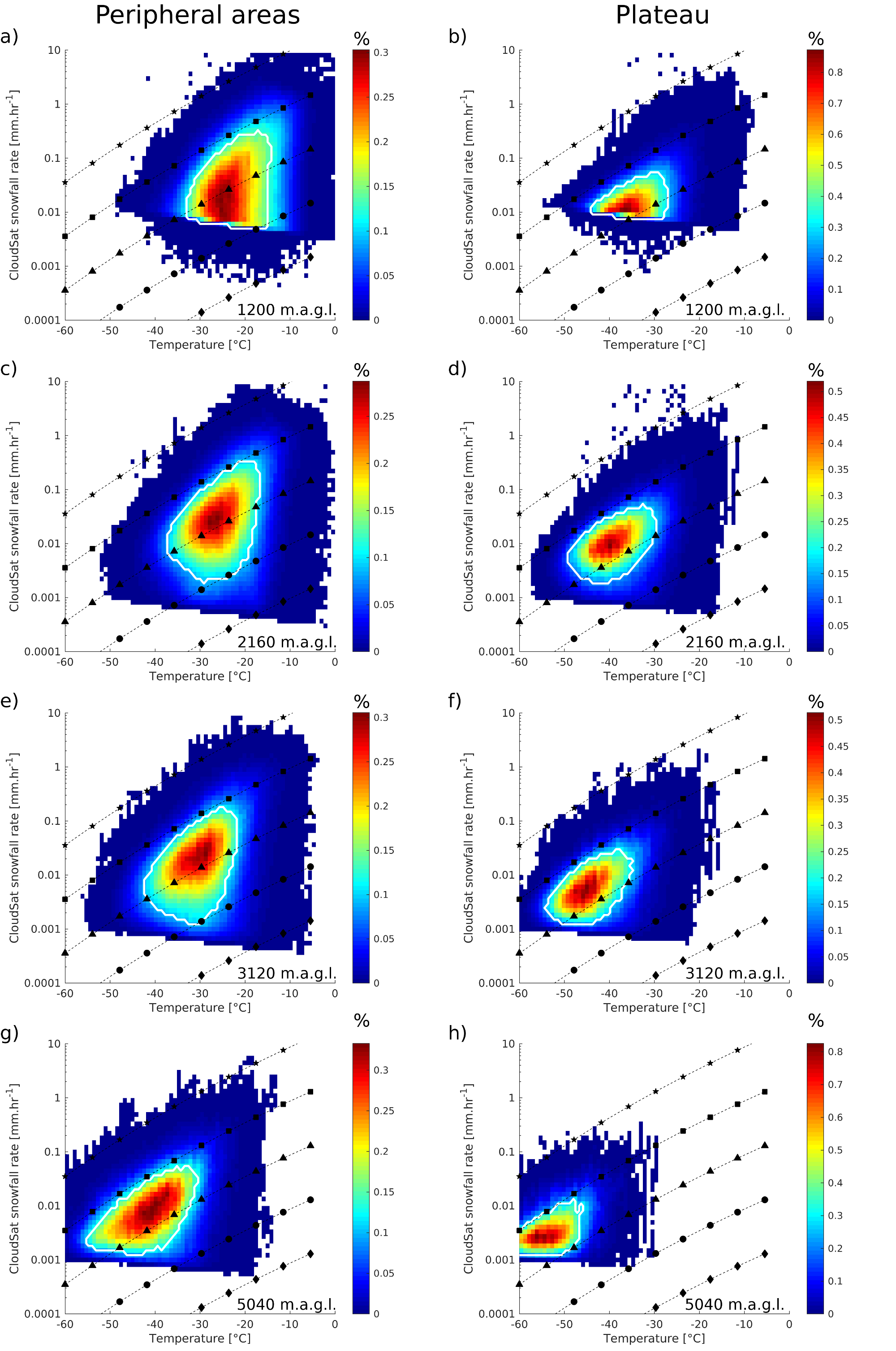
At 1200 m.a.g.l. over peripheral areas on fig. 10.a, most of the precipitation records are located between -32∘C and -14∘C, and between 0.006 mm.hr-1 and 0.25 mm.hr-1. The distribution is bounded between circle and square markers. When continuing to increase in altitude, the distribution follows the orientation of the analytical relationship. At the highest level considered in the fig. 10.g, the spread is located between -55∘C and -31∘C in temperature and ranges from 0.001 mm.hr-1 to 0.005 mm.hr-1 in precipitation rate. Throughout the ascent along the CloudSat bins, the distribution evolves just over the line with the triangles markers, which means a vertical speed of about 0.02 m.s-1. This is again consistent with an orographic precipitation on the margins of the ice-sheet. The table 2 shows the precipitation and temperature locations of these distributions for levels from 5th to 25th CloudSat vertical bins. Above the plateau, on fig. 10.b at 1200 m.a.g.l. the distribution is located between -43∘C and -27∘C. The lower boundary of the distribution is slightly above the theoretical triangles markers line. At this altitude, distribution is highly impacted by ground clutter. At a higher altitude of 2160 m.a.g.l. fig. 10.d, this spread ranges from 0.002 mm.hr-1 to 0.05 mm.hr-1 with a temperature interval of -49∘C to -30∘C. As it evolves with altitude, the distribution continues to follow the line with the triangles markers, but only slightly above it. The table 3 shows the precipitation and temperature locations of these distributions for levels from 5th to 25th CloudSat vertical bin.
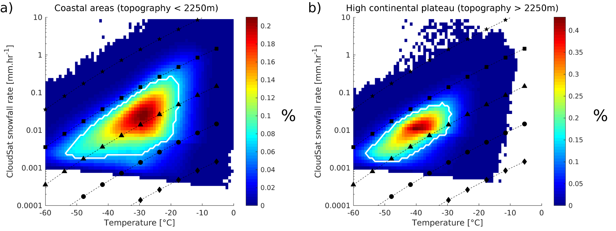
Fig. 11 summarizes distribution of precipitation and temperature summed for all vertical levels. It shows that the distribution over peripheral regions reaches higher temperatures, so its precipitation dispersion is larger at these temperatures. Over peripheral regions, the density-plot is defined for large-scale vertical velocities ranging from 0.0001 (circle markers) to 0.1 m.s-1 (square markers), while over the continental plateau, the distribution is bounded by triangle markers and square markers. Some observations reach very high precipitation rates, and are higher than the analytical relationship showed by square markers with a vertical velocity of 0.1 m.s-1. This is either due to high large-scale winds analogous to extreme events or high slope analogous to local topographical obstacles along the peninsula and mountain ranges. We calculated a precipitation rate with a wind speed of 0.2 m.s-1. This agrees either with a slope of 0.2, corresponding to the slope of the East Antarctic ice cap and a strong large-scale wind blowing at 100 m.s-1 or with a mean large-scale wind of 5 m.s-1 and a steep slope of 4. This covers many possible combinations of strong large scale winds and slopes ranging from the slope of the East Antarctic ice cap to much steeper slopes. Observations on the plateau and coasts that exceed the resulting analytical relationship with a wind speed of 0.2 m.s-1 are showed on fig. 12. In order to verify whether these measurements are made over areas of high topographic gradient, we have reported these measurements on a high-resolution topographic map \citeAgreene2017antarctic and \citeAhowat2019reference in figure 13.
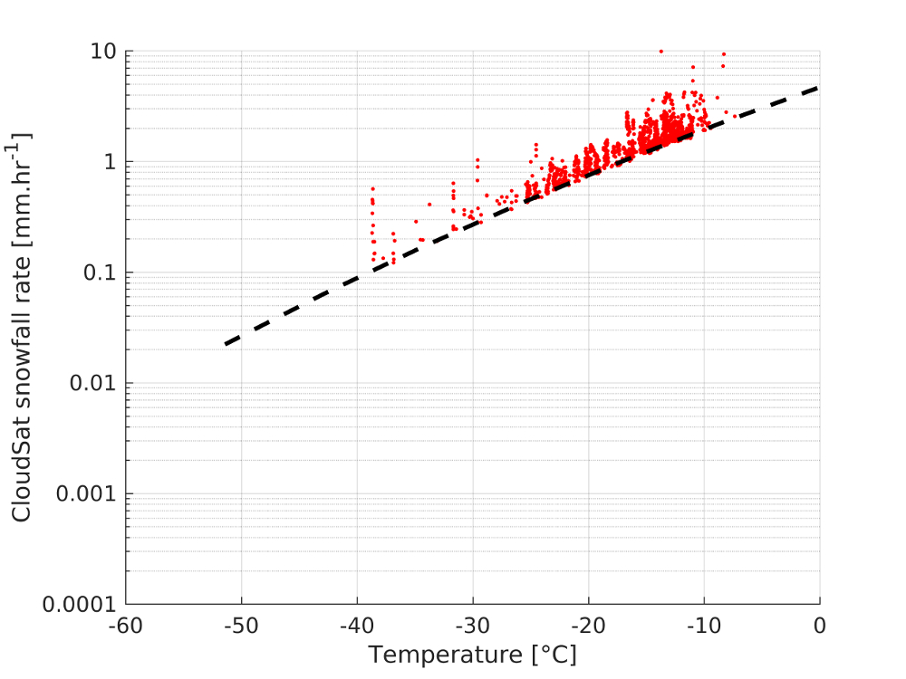
Fig. 13 shows a high-resolution (200 m) topographic map processed by \citeAgreene2017antarctic,howat2019reference over 4 areas where these very high precipitation rates have been recorded by CloudSat. These measurements suggest a vertical velocity of advection at a large scale greater than 0.1 m.s-1, possible only in regions with a high topographic gradient. The slope of the region of Terre Adélie showed on fig. 13.a respects the topographic criterion causing strong vertical winds. Fig. 13.b presenting Ellsworth Land and Mount Vinson massif satisfies the criterion of a high topographic gradient. Indeed, the Mount Vinson massif is a mountain range and the highest point in Antarctica. The peninsula on fig. 13.c, as previously discussed, is a topographic barrier that crosses and obstructs areas with major circumpolar air currents. And the fourth region on fig. 13.d, Dronning Maud, is also respecting the topographic criterion causing strong vertical winds with the presence of a mountainous barrier a few hundred kilometres from the coast. On the four cases, the red dots corresponding to high precipitation measurements follow each others, they correspond to the same satellite track at a given time. These are rare occasional events of massive precipitation that contribute significantly to the accumulation of snow on the continent.
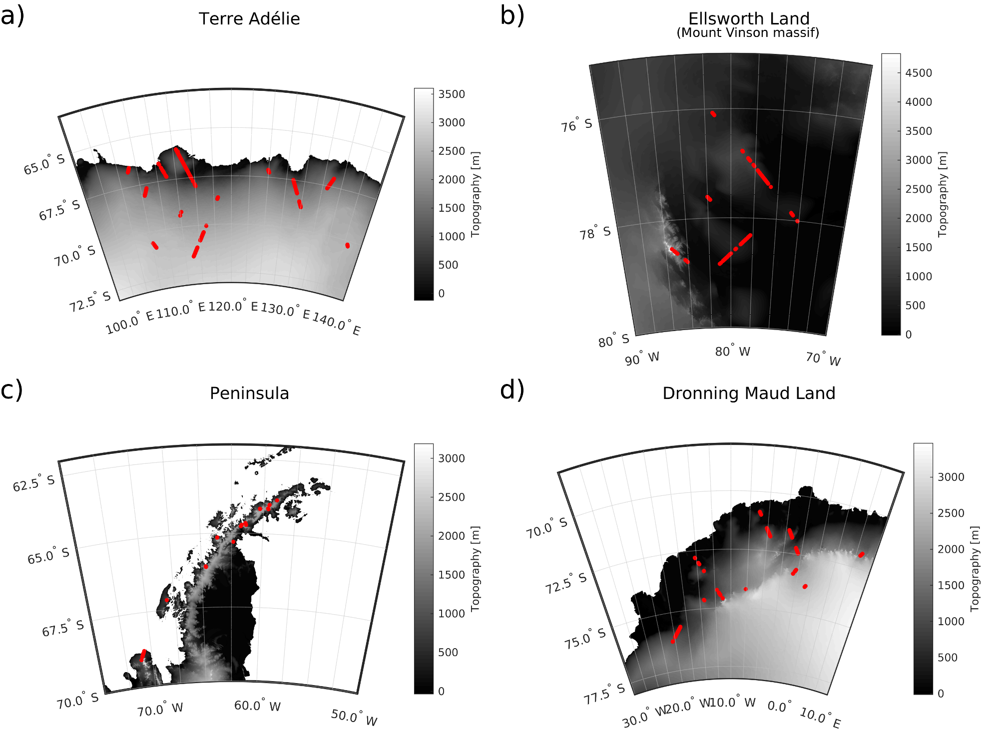
Fig. 14 summarizes the behaviour of precipitation over the Antarctic continent. Precipitation over the peripheral areas occurs with higher temperature by forced lifting of air masses along the topographic slope. The different topographical slopes as well as the strength of the large-scale horizontal wind thus generates different vertical wind velocities. According to equation 1, the variability of these winds consequently generates a wide spread in precipitation rates, identified by the white dashed line contours. Then over the plateau, the available water quantities, temperatures, low slopes and low large-scale horizontal winds cause precipitation to evolve following Clausius-Clapeyron relation with a small spread in precipitation rate. This is represented on fig. 14 by the white solid contours.
5 Conclusion
Precipitation is mostly considered as a surface variable, climatologies typically only reporting the 2D horizontal distribution at the surface. The CloudSat radar dataset now allows to explore the 3D structure of precipitation, and this study provides insight into the origins of precipitation and its evolution along the vertical dimension over Antarctica. The 2C-SNOW-PROFILE product has been explored on the three spatial dimensions and the temporal dimension from 2007 to 2010 over the Antarctic continent. This 3D-dataset is computed following \citeApalerme2014much,palerme2018groundclutter with a horizontal resolution of 1∘ of latitude by 2∘ of longitude grid and a 240 m vertical resolution in order to optimally represent the Southern polar climate. It has been studied over several different regions, geographically divided into four regions (East continent, West continent, West ice-shelves and Peninsula), and topographically divided into two regions: the peripheral areas (where topography 2250 m) and the Antarctic plateau (where topography 2250 m). The distinction between peripheral areas and continental plateau revealed that most of the precipitation is located over the peripheral areas with low relative seasonal variability, in contrast with the plateau where it is relatively high. The study of the four geographical regions revealed many differences between the Peninsula and the western ice-shelves as compared to the continental eastern and western parts. Indeed, the Peninsula is an area where precipitation is strong and mainly driven by local orography and snowfall rates are low over the ice-shelves, while precipitation is increasing along the slope to the ocean over continental eastern and western regions. There also seems to be a strong dichotomy in the behaviour of precipitation over the ice-shelves. This could be related to the sea ice cover, which is able to stratify the atmosphere by cooling it, thus limiting the mixing and thus precipitation.
The pre-gridded CloudSat product is then statistically studied in order to evaluate the distribution of snowfall rates and associated temperatures over the peripheral areas and the plateau at each CloudSat vertical level. This shows that precipitation, whatever the altitude, is mainly driven by large-scale convergence of moist fluxes over the topography. This has been confirmed by comparing the observed precipitation/temperature distributions with an analytical relationship of precipitation as a function of temperature and a vertical advection velocity that is directly dependent on large scale horizontal wind strength and slope. Over the peripheral regions, the dispersion of precipitation rates as a function of temperature is large. This may mean that both topographical slopes and vertical winds are highly diversified. Over the continental plateau, the dispersion is reduced and results from gentler slopes than in peripheral regions, as well as slower vertical uplifts. Thus, the precipitation dispersion at a given temperature of these distributions is justified by varying degrees of horizontal advection on variable slopes. The averaged observed precipitation distribution follows the analytical curve corresponding to a vertical wind of 0.01 m.s-1, which is typical of the values found in general circulation models, for example in our case the IPSL-CM. This new study of the CloudSat precipitation product provides new and innovative tools to evaluate climate models with a three-dimensional view of the atmospheric structure of precipitation. On the one hand, the use of average continental precipitation profiles and zonal averages are diagnostic tools that are easily comparable to models. On the other hand, precipitation rate and temperature scatter-plots require high-frequency model outputs, but lead to a powerful way of evaluating transport, thermodynamics and microphysical processes in further detail.
Appendix A Location of the maximum precipitation rate as a function of altitude
Selected bin values for precipitation rate and temperature as presented in figures 9, 11, 12 and 10.
Temperature:
[-60.0000 -59.1429 -58.2857 -57.4286 -56.5714 -55.7143 -54.8571 -54.0000 -53.1429 -52.2857 -51.4286 -50.5714 -49.7143 -48.8571 -48.0000 -47.1429 -46.2857 -45.4286 -44.5714 -43.7143 -42.8571 -42.0000 -41.1429 -40.2857 -39.4286 -38.5714 -37.7143 -36.8571 -36.0000 -35.1429 -34.2857 -33.4286 -32.5714 -31.7143 -30.8571 -30.0000 -29.1429 -28.2857 -27.4286 -26.5714 -25.7143 -24.8571 -24.0000 -23.1426 -22.2857 -21.4286 -20.5714 -19.7143 -18.8571 -18.0000 -17.1429 -16.2857 -15.4286 -14.5714 -13.7143 -12.8571 -12.0000 -11.1429 -10.2857 -9.4286 -8.5714 -7.7143 -6.8571 -6.0000 -5.1429 -4.2857 -3.4286 -2.5714 -1.7143 -0.8571 0.0000]
Precipitation rate: [0.0001 0.0001 0.0001 0.0002 0.0002 0.0003 0.0003 0.0004 0.0005 0.0006 0.0007 0.0009 0.0011 0.0013 0.0016 0.0020 0.0025 0.0030 0.0037 0.0045 0.0055 0.0067 0.0081 0.0099 0.0122 0.0148 0.0181 0.0221 0.0270 0.0330 0.0403 0.0493 0.0602 0.0735 0.0898 0.1097 0.1340 0.1636 0.1998 0.2441 0.2981 0.3641 0.4447 0.5432 0.6634 0.8103 0.9897 1.2088 1.4765 1.8034 2.2026 2.6903 3.2850 4.0139 4.9021 5.9874 7.3130 8.9321]
The number of decimals for these bins after the decimal point was chosen according to the sensitivity of the CPR measurements.
| Altitude above ground level | Coastal areas | Continental plateau |
|---|---|---|
| 1200 m | 0.0122 – 377278 | 0.0099 – 321044 |
| 1440 m | 0.0181 – 377234 | 0.0122 – 260956 |
| 1680 m | 0.0221 – 351080 | 0.0099 – 212493 |
| 1920 m | 0.0221 – 325865 | 0.0099 – 184575 |
| 2160 m | 0.0221 – 305071 | 0.0081 – 163445 |
| 2400 m | 0.0181 – 288393 | 0.0067 – 146641 |
| 2640 m | 0.0181 – 272086 | 0.0055 – 132604 |
| 2880 m | 0.0181 – 257160 | 0.0055 – 121014 |
| 3120 m | 0.0148 – 243191 | 0.0045 – 110872 |
| 3360 m | 0.0121 – 229763 | 0.0037 – 100530 |
| 3600 m | 0.0121 – 216356 | 0.0030 – 91289 |
| 3840 m | 0.0099 – 201847 | 0.0030 – 83873 |
| 4080 m | 0.0099 – 187903 | 0.0030 – 75265 |
| 4320 m | 0.0081 – 175297 | 0.0025 – 66611 |
| 4560 m | 0.0081 – 164391 | 0.0025 – 57850 |
| 4800 m | 0.0067 – 153230 | 0.0025 – 49477 |
| 5040 m | 0.0055 – 142044 | 0.0025 – 40760 |
| 5280 m | 0.0045 – 131296 | 0.0025 – 32798 |
| 5520 m | 0.0037 – 121678 | 0.0025 – 25271 |
| 5760 m | 0.0030 – 111769 | 0.0025 – 19258 |
| 6000 m | 0.0030 – 103270 | 0.0025 – 14080 |
| Altitude above ground level | Precipitation rate in mm.hr | Temperature in ∘C |
|---|---|---|
| 1200 m | 0.0148 [0.0055 – 0.2981] | -25.7143 [-32.5714 – -14.5714] |
| 1440 m | 0.0181 [0.0055 – 0.2981] | -25.7143 [-33.4286 – -14.5714] |
| 1680 m | 0.0270 [0.0037 – 0.3641] | -25.7143 [-35.1429 – -14.5714] |
| 1920 m | 0.0270 [0.0030 – 0.2981] | -26.5714 [-36.0000 – -16.2857] |
| 2160 m | 0.0221 [0.0020 – 0.2981] | -28.2857 [-17.1429 – -36.8571] |
| 2400 m | 0.0221 [0.0020 – 0.2441] | -30.0000 [-38.5714 – -18.0000] |
| 2640 m | 0.0270 [0.0013 – 0.1998] | -28.2857 [-40.2857 – -18.8571] |
| 2880 m | 0.0270 [0.0013 – 0.1636] | -28.2857 [-41.1429 – -20.5714] |
| 3120 m | 0.0221 [0.0013 – 0.1636] | -29.1429 [-42.0000 – -22.2857] |
| 3360 m | 0.0221 [0.0013 – 0.1339] | -30.0000 [-43.7143 – -23.1429] |
| 3600 m | 0.0181 [0.0013 – 0.1339] | -31.7143 [-45.4286 – -24.0000] |
| 3840 m | 0.0122 [0.0016 – 0.1097] | -35.1429 [-48.0000 – -24.8571] |
| 4080 m | 0.0148 [0.0016 – 0.0898] | -36.0000 [-48.8571 – -26.5714] |
| 4320 m | 0.0099 [0.0013 – 0.0735] | -38.5714 [-49.7143 – -28.2857] |
| 4560 m | 0.0099 [0.0013 – 0.0602] | -37.7143 [-50.5714 – -29.1429] |
| 4800 m | 0.0067 [0.0013 – 0.0602] | -41.1429 [-41.1429 – -30.0000] |
| 5040 m | 0.0099 [0.0013 – 0.0493] | -40.2857 [-54.8571 – -30.8571] |
| 5280 m | 0.0055 [0.0013 – 0.0404] | -43.7143 [-55.7143 – -33.4286] |
| 5520 m | 0.0055 [0.0013 – 0.0330] | -45.4286 [-56.5714 – -35.1429] |
| 5760 m | 0.0037 [0.0013 – 0.0270] | -48.0000 [-56.5714 – -35.1429] |
| 6000 m | 0.0030 [0.0013 – 0.0270] | -48.0000 [-57.4286 – -36.0000] |
| Altitude above ground level | Precipitation rate in mm.hr | Temperature in ∘C |
|---|---|---|
| 1200 m | 0.0099 [0.0081 – 0.0493] | -36.8571 [-43.7143 – -27.4286] |
| 1440 m | 0.0122 [0.0055 – 0.0602] | -37.7143 [-45.4286 – -27.4286] |
| 1680 m | 0.0099 [0.0037 – 0.0602] | -38.5714 [-46.2857 – -28.2857] |
| 1920 m | 0.0099 [0.0030 – 0.0493] | -38.5714 [-47.1429 – -28.2857] |
| 2160 m | 0.0081 [0.0020 – 0.0493] | -40.2857 [-48.8571 – -30.0000] |
| 2400 m | 0.0099 [0.0016 – 0.0403] | -40.2857 [-49.7143 – -31.7143] |
| 2640 m | 0.0067 [0.0013 – 0.0330] | -42.0000 [-50.5714 – -32.5714] |
| 2880 m | 0.0055 [0.0013 – 0.0330] | -43.7143 [-52.2857 – -34.2857] |
| 3120 m | 0.0055 [0.0013 – 0.0270] | -45.4286 [-54.0000 – -35.1429] |
| 3360 m | 0.0037 [0.0013 – 0.0221] | -48.0000 [-54.8571 – -36.8571] |
| 3600 m | 0.0037 [0.0013 – 0.0221] | -48.8571 [-55.7143 – -38.5714] |
| 3840 m | 0.0030 [0.0016 – 0.0181] | -49.7143 [-56.5714 – -39.4286] |
| 4080 m | 0.0030 [0.0011 – 0.0181] | -51.4286 [-58.2857 – -41.1429] |
| 4320 m | 0.0025 [0.0011 – 0.0148] | -53.1429 [-59.1429 – -42.8571] |
| 4560 m | 0.0030 [0.0011 – 0.0122] | -53.1429 [-50.5714 – -29.1429] |
| 4800 m | 0.0025 [0.0011 – 0.0122] | -54.8571 [-60.0000 – -45.4286] |
| 5040 m | 0.0025 [0.0013 – 0.0122] | -56.5714 [-60.0000 – -46.2857] |
| 5280 m | 0.0025 [0.0013 – 0.0099] | -56.5714 [-60.0000 – -46.2857] |
| 5520 m | 0.0025 [0.0011 – 0.0099] | -59.1429 [-60.0000 – -48.0000] |
| 5760 m | 0.0025 [0.0011 – 0.0099] | -59.1429 [-60.0000 – -49.7143] |
| 6000 m | 0.0025 [0.0011 – 0.0081] | -55.7143 [-60.0000 – -49.7143] |
Appendix B Precipitation at saturation by forced lifting demonstation
All the air advected into the pole would condense by forced lifting due to the topographical landmass of the continent. We assume a purely vertical motion initiated from a horizontal advection at the origin of large-scale precipitation. The vertical motion of the air mass implies a cooling and a variation in the saturation vapour pressure, and therefore in the precipitation rate. We use moisture flow convergence equations and test several vertical wind values in order to explain precipitation observations. This is based on the net moisture balance in a steady state saturated atmosphere and can be derived from:
| (2) |
where is the lagrangian derivative:
| (3) |
with , and , representing the standard three-dimensional wind components, and is the specific humidity. represents the budget of water vapor, which is defined by the difference between sources and sinks of water vapor following air parcel motion. typically takes the form , where is the evaporation rate into the air parcel and is the precipitation rate.
| (4) |
If we assume that the lifted parcels are brought to saturation, kg.kg-1.s-1, and in steady state, kg.kg-1.s-1 so:
| (5) |
Assuming a purely vertical motion, we finally reach the form:
| (6) |
We can therefore assess the precipitation rate by integrating a vertical flux over the column observed by CloudSat at a given constant :
| (7) |
The term can be decomposed and then described from Clausius Clapeyron’s equation as follow:
| (8) |
with . At a constant pressure:
| (9) |
with the latent heat of sublimation and the specific gas constant for wet air . Since we assume that we are at saturation, / is the moist adiabatic lapse rate with a value of -6.5 K.km-1. The definitive form of the precipitation equation is:
| (10) |
Acknowledgements.
This work was supported by the French National Research Agency (Grant number : ANR-15-CE01-0003). CloudSat data is freely available via the CloudSat Data Processing Center (http://www.cloudsat.cira.colostate.edu/). The authors thank Karine Marquois and the IT department of the Laboratoire de Météorologie Dynamique for the informatics support to generate the 3D climatology. The authors thank Anna-Lea Albright, Margaux Valls, Luca Montabone and Mélanie Thiriet for the proofreading.References
- Bromwich (\APACyear1988) \APACinsertmetastarbromwich1988snowfall{APACrefauthors}Bromwich, D\BPBIH. \APACrefYearMonthDay1988. \BBOQ\APACrefatitleSnowfall in high southern latitudes Snowfall in high southern latitudes.\BBCQ \APACjournalVolNumPagesReviews of Geophysics261149–168. \PrintBackRefs\CurrentBib
- Bromwich \BBA Parish (\APACyear1998) \APACinsertmetastarbromwich1998meteorology{APACrefauthors}Bromwich, D\BPBIH.\BCBT \BBA Parish, T\BPBIR. \APACrefYearMonthDay1998. \BBOQ\APACrefatitleMeteorology of the Antarctic Meteorology of the antarctic.\BBCQ \BIn \APACrefbtitleMeteorology of the Southern Hemisphere Meteorology of the southern hemisphere (\BPGS 175–200). \APACaddressPublisherSpringer. \PrintBackRefs\CurrentBib
- Church \BOthers. (\APACyear2013) \APACinsertmetastarchurch2013sea{APACrefauthors}Church, J\BPBIA., Clark, P\BPBIU., Cazenave, A., Gregory, J\BPBIM., Jevrejeva, S., Levermann, A.\BDBLothers \APACrefYearMonthDay2013. \BBOQ\APACrefatitleSea-level rise by 2100 Sea-level rise by 2100.\BBCQ \APACjournalVolNumPagesScience34261651445–1445. \PrintBackRefs\CurrentBib
- Durán-Alarcón \BOthers. (\APACyear2019) \APACinsertmetastarduranalarcon2018VPR{APACrefauthors}Durán-Alarcón, C., Boudevillain, B., Genthon, C., Grazioli, J., Souverijns, N., van Lipzig, N\BPBIP\BPBIM.\BDBLBerne, A. \APACrefYearMonthDay2019. \BBOQ\APACrefatitleThe vertical structure of precipitation at two stations in East Antarctica derived from micro rain radars The vertical structure of precipitation at two stations in east antarctica derived from micro rain radars.\BBCQ \APACjournalVolNumPagesThe Cryosphere131247–264. {APACrefURL} https://www.the-cryosphere.net/13/247/2019/ {APACrefDOI} 10.5194/tc-13-247-2019 \PrintBackRefs\CurrentBib
- Dye \BOthers. (\APACyear1974) \APACinsertmetastardye1974mechanism{APACrefauthors}Dye, J\BPBIE., Knight, C\BPBIA., Toutenhoofd, V.\BCBL \BBA Cannon, T\BPBIW. \APACrefYearMonthDay1974. \BBOQ\APACrefatitleThe mechanism of precipitation formation in northeastern Colorado cumulus III. Coordinated microphysical and radar observations and summary The mechanism of precipitation formation in northeastern colorado cumulus iii. coordinated microphysical and radar observations and summary.\BBCQ \APACjournalVolNumPagesJournal of the Atmospheric Sciences3182152–2159. \PrintBackRefs\CurrentBib
- Eisen \BOthers. (\APACyear2008) \APACinsertmetastareisen2008ground{APACrefauthors}Eisen, O., Frezzotti, M., Genthon, C., Isaksson, E., Magand, O., van den Broeke, M\BPBIR.\BDBLothers \APACrefYearMonthDay2008. \BBOQ\APACrefatitleGround-based measurements of spatial and temporal variability of snow accumulation in East Antarctica Ground-based measurements of spatial and temporal variability of snow accumulation in east antarctica.\BBCQ \APACjournalVolNumPagesReviews of Geophysics462. \PrintBackRefs\CurrentBib
- Findeisen \BOthers. (\APACyear2015) \APACinsertmetastarfindeisen2015colloidal{APACrefauthors}Findeisen, W., Volken, E., Giesche, A\BPBIM.\BCBL \BBA Brönnimann, S. \APACrefYearMonthDay2015. \BBOQ\APACrefatitleColloidal meteorological processes in the formation of precipitation Colloidal meteorological processes in the formation of precipitation.\BBCQ \APACjournalVolNumPagesMeteorologische Zeitschrift244443–454. \PrintBackRefs\CurrentBib
- Fujita \BBA Abe (\APACyear2006) \APACinsertmetastarfujita2006stable{APACrefauthors}Fujita, K.\BCBT \BBA Abe, O. \APACrefYearMonthDay2006. \BBOQ\APACrefatitleStable isotopes in daily precipitation at Dome Fuji, East Antarctica Stable isotopes in daily precipitation at dome fuji, east antarctica.\BBCQ \APACjournalVolNumPagesGeophysical research letters3318. \PrintBackRefs\CurrentBib
- Genthon \BOthers. (\APACyear2009) \APACinsertmetastargenthon2009antarctic{APACrefauthors}Genthon, C., Krinner, G.\BCBL \BBA Castebrunet, H. \APACrefYearMonthDay2009. \BBOQ\APACrefatitleAntarctic precipitation and climate-change predictions: horizontal resolution and margin vs plateau issues Antarctic precipitation and climate-change predictions: horizontal resolution and margin vs plateau issues.\BBCQ \APACjournalVolNumPagesAnnals of Glaciology505055–60. \PrintBackRefs\CurrentBib
- Gorodetskaya \BOthers. (\APACyear2014) \APACinsertmetastargorodetskaya2014role{APACrefauthors}Gorodetskaya, I\BPBIV., Tsukernik, M., Claes, K., Ralph, M\BPBIF., Neff, W\BPBID.\BCBL \BBA Van Lipzig, N\BPBIP. \APACrefYearMonthDay2014. \BBOQ\APACrefatitleThe role of atmospheric rivers in anomalous snow accumulation in East Antarctica The role of atmospheric rivers in anomalous snow accumulation in east antarctica.\BBCQ \APACjournalVolNumPagesGeophysical Research Letters41176199–6206. \PrintBackRefs\CurrentBib
- Grazioli, Genthon\BCBL \BOthers. (\APACyear2017) \APACinsertmetastargrazioli2017measurements{APACrefauthors}Grazioli, J., Genthon, C., Boudevillain, B., Duran-Alarcon, C., Del Guasta, M., Jean-Baptiste, M.\BCBL \BBA Berne, A. \APACrefYearMonthDay2017. \BBOQ\APACrefatitleMeasurements of precipitation in Dumont d’Urville, Adélie Land, East Antarctica Measurements of precipitation in dumont d’urville, adélie land, east antarctica.\BBCQ \APACjournalVolNumPagesThe Cryosphere1141797. \PrintBackRefs\CurrentBib
- Grazioli, Madeleine\BCBL \BOthers. (\APACyear2017) \APACinsertmetastargrazioli2017katabatic{APACrefauthors}Grazioli, J., Madeleine, J\BHBIB., Gallée, H., Forbes, R\BPBIM., Genthon, C., Krinner, G.\BCBL \BBA Berne, A. \APACrefYearMonthDay2017. \BBOQ\APACrefatitleKatabatic winds diminish precipitation contribution to the Antarctic ice mass balance Katabatic winds diminish precipitation contribution to the antarctic ice mass balance.\BBCQ \APACjournalVolNumPagesProceedings of the National Academy of Sciences1144110858–10863. \PrintBackRefs\CurrentBib
- Greene \BOthers. (\APACyear2017) \APACinsertmetastargreene2017antarctic{APACrefauthors}Greene, C\BPBIA., Gwyther, D\BPBIE.\BCBL \BBA Blankenship, D\BPBID. \APACrefYearMonthDay2017. \BBOQ\APACrefatitleAntarctic mapping tools for MATLAB Antarctic mapping tools for matlab.\BBCQ \APACjournalVolNumPagesComputers & Geosciences104151–157. \PrintBackRefs\CurrentBib
- Howat \BOthers. (\APACyear2019) \APACinsertmetastarhowat2019reference{APACrefauthors}Howat, I\BPBIM., Porter, C., Smith, B\BPBIE., Noh, M\BHBIJ.\BCBL \BBA Morin, P. \APACrefYearMonthDay2019. \BBOQ\APACrefatitleThe Reference Elevation Model of Antarctica The reference elevation model of antarctica.\BBCQ \APACjournalVolNumPagesThe Cryosphere132665–674. \PrintBackRefs\CurrentBib
- King \BBA Turner (\APACyear2007) \APACinsertmetastarking2007antarctic{APACrefauthors}King, J\BPBIC.\BCBT \BBA Turner, J. \APACrefYear2007. \APACrefbtitleAntarctic meteorology and climatology Antarctic meteorology and climatology. \APACaddressPublisherCambridge University Press. \PrintBackRefs\CurrentBib
- Knuth \BOthers. (\APACyear2010) \APACinsertmetastarknuth2010influence{APACrefauthors}Knuth, S\BPBIL., Tripoli, G\BPBIJ., Thom, J\BPBIE.\BCBL \BBA Weidner, G\BPBIA. \APACrefYearMonthDay2010. \BBOQ\APACrefatitleThe influence of blowing snow and precipitation on snow depth change across the Ross Ice Shelf and Ross Sea regions of Antarctica The influence of blowing snow and precipitation on snow depth change across the ross ice shelf and ross sea regions of antarctica.\BBCQ \APACjournalVolNumPagesJournal of Applied Meteorology and Climatology4961306–1321. \PrintBackRefs\CurrentBib
- Kulie \BOthers. (\APACyear2016) \APACinsertmetastarkulie2016shallow{APACrefauthors}Kulie, M\BPBIS., Milani, L., Wood, N\BPBIB., Tushaus, S\BPBIA., Bennartz, R.\BCBL \BBA L’Ecuyer, T\BPBIS. \APACrefYearMonthDay2016. \BBOQ\APACrefatitleA shallow cumuliform snowfall census using spaceborne radar A shallow cumuliform snowfall census using spaceborne radar.\BBCQ \APACjournalVolNumPagesJournal of Hydrometeorology1741261–1279. \PrintBackRefs\CurrentBib
- Lachlan-Cope \BOthers. (\APACyear2001) \APACinsertmetastarlachlan2001observations{APACrefauthors}Lachlan-Cope, T., Ladkin, R., Turner, J.\BCBL \BBA Davison, P. \APACrefYearMonthDay2001. \BBOQ\APACrefatitleObservations of cloud and precipitation particles on the Avery Plateau, Antarctic Peninsula Observations of cloud and precipitation particles on the avery plateau, antarctic peninsula.\BBCQ \APACjournalVolNumPagesAntarctic Science133339–348. \PrintBackRefs\CurrentBib
- Lawson \BOthers. (\APACyear2006) \APACinsertmetastarlawson2006microphysical{APACrefauthors}Lawson, R\BPBIP., Baker, B\BPBIA., Zmarzly, P., O’Connor, D., Mo, Q., Gayet, J\BHBIF.\BCBL \BBA Shcherbakov, V. \APACrefYearMonthDay2006. \BBOQ\APACrefatitleMicrophysical and optical properties of atmospheric ice crystals at South Pole Station Microphysical and optical properties of atmospheric ice crystals at south pole station.\BBCQ \APACjournalVolNumPagesJournal of Applied Meteorology and Climatology45111505–1524. \PrintBackRefs\CurrentBib
- Lemonnier \BOthers. (\APACyear2019) \APACinsertmetastarlemonnier2018evaluation{APACrefauthors}Lemonnier, F., Madeleine, J., Claud, C., Genthon, C., Durán-Alarcón, C., Palerme, C.\BDBLothers \APACrefYearMonthDay2019. \BBOQ\APACrefatitleEvaluation of CloudSat snowfall rate profiles by a comparison with in-situ micro rain radars observations in East Antarctica Evaluation of cloudsat snowfall rate profiles by a comparison with in-situ micro rain radars observations in east antarctica.\BBCQ \APACjournalVolNumPagesThe Cryosphere, https://doi. org/10.5194/tc-2018-236. \PrintBackRefs\CurrentBib
- Lenaerts \BOthers. (\APACyear2018) \APACinsertmetastarlenaerts2018signature{APACrefauthors}Lenaerts, J\BPBIT., Fyke, J.\BCBL \BBA Medley, B. \APACrefYearMonthDay2018. \BBOQ\APACrefatitleThe signature of ozone depletion in recent Antarctic precipitation change: A study with the Community Earth System Model The signature of ozone depletion in recent antarctic precipitation change: A study with the community earth system model.\BBCQ \APACjournalVolNumPagesGeophysical Research Letters452312–931. \PrintBackRefs\CurrentBib
- Liu \BOthers. (\APACyear2008) \APACinsertmetastarliu2008cloud{APACrefauthors}Liu, C., Zipser, E\BPBIJ., Cecil, D\BPBIJ., Nesbitt, S\BPBIW.\BCBL \BBA Sherwood, S. \APACrefYearMonthDay2008. \BBOQ\APACrefatitleA cloud and precipitation feature database from nine years of TRMM observations A cloud and precipitation feature database from nine years of trmm observations.\BBCQ \APACjournalVolNumPagesJournal of Applied Meteorology and Climatology47102712–2728. \PrintBackRefs\CurrentBib
- Maahn \BOthers. (\APACyear2014) \APACinsertmetastarmaahn2014{APACrefauthors}Maahn, M., Burgard, C., Crewell, S., Gorodetskaya, I\BPBIV., Kneifel, S., Lhermitte, S.\BDBLvan Lipzig, N\BPBIP. \APACrefYearMonthDay2014. \BBOQ\APACrefatitleHow does the spaceborne radar blind zone affect derived surface snowfall statistics in polar regions? How does the spaceborne radar blind zone affect derived surface snowfall statistics in polar regions?\BBCQ \APACjournalVolNumPagesJournal of Geophysical Research: Atmospheres1192413–604. \PrintBackRefs\CurrentBib
- Milani \BOthers. (\APACyear2018) \APACinsertmetastarmilani2018cloudsat{APACrefauthors}Milani, L., Kulie, M\BPBIS., Casella, D., Dietrich, S., L’Ecuyer, T\BPBIS., Panegrossi, G.\BDBLWood, N\BPBIB. \APACrefYearMonthDay2018. \BBOQ\APACrefatitleCloudSat snowfall estimates over Antarctica and the Southern Ocean: An assessment of independent retrieval methodologies and multi-year snowfall analysis Cloudsat snowfall estimates over antarctica and the southern ocean: An assessment of independent retrieval methodologies and multi-year snowfall analysis.\BBCQ \APACjournalVolNumPagesAtmospheric research213121–135. \PrintBackRefs\CurrentBib
- Nicolas \BBA Bromwich (\APACyear2011) \APACinsertmetastarnicolas2011climate{APACrefauthors}Nicolas, J\BPBIP.\BCBT \BBA Bromwich, D\BPBIH. \APACrefYearMonthDay2011. \BBOQ\APACrefatitleClimate of West Antarctica and influence of marine air intrusions Climate of west antarctica and influence of marine air intrusions.\BBCQ \APACjournalVolNumPagesJournal of Climate24149–67. \PrintBackRefs\CurrentBib
- Palerme \BOthers. (\APACyear2019) \APACinsertmetastarpalerme2018groundclutter{APACrefauthors}Palerme, C., Claud, C., Wood, N., L’Ecuyer, T.\BCBL \BBA Genthon, C. \APACrefYearMonthDay2019. \BBOQ\APACrefatitleHow does ground clutter affect CloudSat snowfall retrievals over ice sheets? How does ground clutter affect cloudsat snowfall retrievals over ice sheets?\BBCQ \APACjournalVolNumPagesIEEE Geoscience And Remote Sensing Letters, VOL 16, 342-346. \PrintBackRefs\CurrentBib
- Palerme \BOthers. (\APACyear2017) \APACinsertmetastarpalerme2017evaluation{APACrefauthors}Palerme, C., Genthon, C., Claud, C., Kay, J\BPBIE., Wood, N\BPBIB.\BCBL \BBA L Ecuyer, T. \APACrefYearMonthDay2017. \BBOQ\APACrefatitleEvaluation of current and projected Antarctic precipitation in CMIP5 models Evaluation of current and projected antarctic precipitation in cmip5 models.\BBCQ \APACjournalVolNumPagesClimate Dynamics481-2225–239. \PrintBackRefs\CurrentBib
- Palerme \BOthers. (\APACyear2014) \APACinsertmetastarpalerme2014much{APACrefauthors}Palerme, C., Kay, J., Genthon, C., L’Ecuyer, T., Wood, N.\BCBL \BBA Claud, C. \APACrefYearMonthDay2014. \BBOQ\APACrefatitleHow much snow falls on the Antarctic ice sheet? How much snow falls on the antarctic ice sheet?\BBCQ \APACjournalVolNumPagesThe Cryosphere841577–1587. \PrintBackRefs\CurrentBib
- Pritchard \BOthers. (\APACyear2012) \APACinsertmetastarpritchard2012antarctic{APACrefauthors}Pritchard, H., Ligtenberg, S., Fricker, H., Vaughan, D., Van den Broeke, M.\BCBL \BBA Padman, L. \APACrefYearMonthDay2012. \BBOQ\APACrefatitleAntarctic ice-sheet loss driven by basal melting of ice shelves Antarctic ice-sheet loss driven by basal melting of ice shelves.\BBCQ \APACjournalVolNumPagesNature4847395502. \PrintBackRefs\CurrentBib
- Rignot \BOthers. (\APACyear2019) \APACinsertmetastarrignot2019four{APACrefauthors}Rignot, E., Mouginot, J., Scheuchl, B., van den Broeke, M., van Wessem, M\BPBIJ.\BCBL \BBA Morlighem, M. \APACrefYearMonthDay2019. \BBOQ\APACrefatitleFour decades of Antarctic Ice Sheet mass balance from 1979–2017 Four decades of antarctic ice sheet mass balance from 1979–2017.\BBCQ \APACjournalVolNumPagesProceedings of the National Academy of Sciences11641095–1103. \PrintBackRefs\CurrentBib
- Rodgers (\APACyear2000) \APACinsertmetastarrodgers2000inverse{APACrefauthors}Rodgers, C\BPBID. \APACrefYear2000. \APACrefbtitleInverse methods for atmospheric sounding: theory and practice Inverse methods for atmospheric sounding: theory and practice (\BVOL 2). \APACaddressPublisherWorld scientific. \PrintBackRefs\CurrentBib
- Schweiger \BOthers. (\APACyear2008) \APACinsertmetastarschweiger2008relationships{APACrefauthors}Schweiger, A\BPBIJ., Lindsay, R\BPBIW., Vavrus, S.\BCBL \BBA Francis, J\BPBIA. \APACrefYearMonthDay2008. \BBOQ\APACrefatitleRelationships between Arctic sea ice and clouds during autumn Relationships between arctic sea ice and clouds during autumn.\BBCQ \APACjournalVolNumPagesJournal of Climate21184799–4810. \PrintBackRefs\CurrentBib
- Shepherd \BOthers. (\APACyear2018) \APACinsertmetastarshepherd2018mass{APACrefauthors}Shepherd, A., Ivins, E., Rignot, E., Smith, B., Van Den Broeke, M., Velicogna, I.\BDBLothers \APACrefYearMonthDay2018. \BBOQ\APACrefatitleMass balance of the Antarctic Ice Sheet from 1992 to 2017 Mass balance of the antarctic ice sheet from 1992 to 2017.\BBCQ \APACjournalVolNumPagesNature558219–222. \PrintBackRefs\CurrentBib
- Shepherd \BOthers. (\APACyear2012) \APACinsertmetastarshepherd2012reconciled{APACrefauthors}Shepherd, A., Ivins, E\BPBIR., Geruo, A., Barletta, V\BPBIR., Bentley, M\BPBIJ., Bettadpur, S.\BDBLothers \APACrefYearMonthDay2012. \BBOQ\APACrefatitleA reconciled estimate of ice-sheet mass balance A reconciled estimate of ice-sheet mass balance.\BBCQ \APACjournalVolNumPagesScience33861111183–1189. \PrintBackRefs\CurrentBib
- Souverijns \BOthers. (\APACyear2018) \APACinsertmetastarsouverijns2018cloudsatgrid{APACrefauthors}Souverijns, N., Gossart, A., Lhermitte, S., Gorodetskaya, I\BPBIV., Grazioli, J., Berne, A.\BDBLvan Lipzig, N\BPBIP\BPBIM. \APACrefYearMonthDay2018. \BBOQ\APACrefatitleEvaluation of the CloudSat surface snowfall product over Antarctica using ground-based precipitation radars Evaluation of the cloudsat surface snowfall product over antarctica using ground-based precipitation radars.\BBCQ \APACjournalVolNumPagesThe Cryosphere12123775–3789. {APACrefURL} https://www.the-cryosphere.net/12/3775/2018/ {APACrefDOI} 10.5194/tc-12-3775-2018 \PrintBackRefs\CurrentBib
- Stephens \BBA Ellis (\APACyear2008) \APACinsertmetastarstephens2008controls{APACrefauthors}Stephens, G\BPBIL.\BCBT \BBA Ellis, T\BPBID. \APACrefYearMonthDay2008. \BBOQ\APACrefatitleControls of global-mean precipitation increases in global warming GCM experiments Controls of global-mean precipitation increases in global warming gcm experiments.\BBCQ \APACjournalVolNumPagesJournal of Climate21236141–6155. \PrintBackRefs\CurrentBib
- Turner \BOthers. (\APACyear2019) \APACinsertmetastarturner2019dominant{APACrefauthors}Turner, J., Phillips, T., Thamban, M., Rahaman, W., Marshall, G\BPBIJ., Wille, J\BPBID.\BDBLothers \APACrefYearMonthDay2019. \BBOQ\APACrefatitleThe Dominant Role of Extreme Precipitation Events in Antarctic Snowfall Variability The dominant role of extreme precipitation events in antarctic snowfall variability.\BBCQ \APACjournalVolNumPagesGeophysical Research Letters4663502–3511. \PrintBackRefs\CurrentBib
- Van de Berg \BOthers. (\APACyear2007) \APACinsertmetastarvan2007heat{APACrefauthors}Van de Berg, W., Van den Broeke, M.\BCBL \BBA Van Meijgaard, E. \APACrefYearMonthDay2007. \BBOQ\APACrefatitleHeat budget of the East Antarctic lower atmosphere derived from a regional atmospheric climate model Heat budget of the east antarctic lower atmosphere derived from a regional atmospheric climate model.\BBCQ \APACjournalVolNumPagesJournal of Geophysical Research: Atmospheres112D23. \PrintBackRefs\CurrentBib
- Wood (\APACyear2011) \APACinsertmetastarwood2011estimation{APACrefauthors}Wood, N\BPBIB. \APACrefYearMonthDay2011. \BBOQ\APACrefatitleEstimation of snow microphysical properties with application to millimeter-wavelength radar retrievals for snowfall rate (PhD thesis) Estimation of snow microphysical properties with application to millimeter-wavelength radar retrievals for snowfall rate (phd thesis).\BBCQ \PrintBackRefs\CurrentBib
- Wood \BOthers. (\APACyear2014) \APACinsertmetastarwood2014estimating{APACrefauthors}Wood, N\BPBIB., L’Ecuyer, T\BPBIS., Heymsfield, A\BPBIJ., Stephens, G\BPBIL., Hudak, D\BPBIR.\BCBL \BBA Rodriguez, P. \APACrefYearMonthDay2014. \BBOQ\APACrefatitleEstimating snow microphysical properties using collocated multisensor observations Estimating snow microphysical properties using collocated multisensor observations.\BBCQ \APACjournalVolNumPagesJournal of Geophysical Research: Atmospheres119148941–8961. \PrintBackRefs\CurrentBib