MQTTg: An Android Implementation
Abstract
The Internet of Things (IoT) age is upon us. As we look to build larger networks with more devices connected to the Internet, the need for lightweight protocols that minimize the use of both energy and computation gain popularity. One such protocol is Message Queue Telemetry Transport (MQTT). Since its introduction in 1999, it has slowly increased in use cases and gained a huge spike in popularity since it was used in the popular messaging application Facebook Messenger. In our previous works, we focused on adding geolocation to MQTT, to help modernize the protocol into the IoT age. In this paper, we build off our previous work on MQTTg and build an IoT Android Application that can pull geolocation information from the Operating System. We then use the geolocation data to create geofences to help further tailor the use cases of MQTTg.
Keywords :
Internet of things, MQTT, geolocation, network protocols, Android, MQTTnet, PahoI Introduction
The Internet of Things (IoT) at its core looks to improve our ability as technologists to implement better data sharing, remote control, and data monitoring [1]. IoT can achieve this by connecting almost any device to the Internet [2, 3]. One of IoT's gems is the recently popular idea of Smart cities and Smart factories, where entire geographic locations or workplaces have devices connected into a network being able to share information [4]. For smart cities and other IoT ideas, communication protocols for acquisition of large amounts of data and sharing of that data are very important. One such protocol is MQTT.
Vergara et al. in [5] were one of the first to show the superiority of MQTT implemented on Android devices to decrease energy consumption. Furthermore, we now know from a large collection of use cases that MQTT provides some key advantages like a small energy footprint and very low bandwidth use [6]. Furthermore, even in comparison to other IoT protocols, MQTT also provides advantages in smartphone use [7]. A favorable picture of MQTT based techniques for data communication problems on IoT networks has been painted thus far in related literature [8, 9, 10, 11]. Our initial work on MQTT started in [12, 13] we attempted to add geolocation to an existing MQTT release known as Mosquitto [6]. However, due to shortcomings with the implementation, we switched to MQTTNet [14] and presented our work very recently in [15]. In this paper we aim to implement the usability of the MQTTg protocol with added geolocation on mobile based applications in the Android Operating System.
The rest of the paper is organized as follows. In section I-A we give a brief overview of MQTT. We follow this with our main contributions in section I-B. We then present main results in section II followed by some experimental work in section III. We end the paper with some future directions in section IV and end with some concluding remarks in section V.
I-A MQTT Protocol
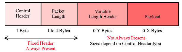
The MQTT protocol is a well known publish/subscribe protocol. MQTT relies on publishers to publish content and subscribers to subscribe to given topics to retrieve all messages relating to a given topic. In most implementations, there is a broker that routes information to where it needs to go. Historically, the MQTT protocol runs over TCP/IP and has a data packet size with low overhead minimum ( bytes) so that consumption of power is kept to a minimum. Although we do not discuss the MQTT protocol in depth here, we recommend interested readers to the MQTT documentation in [14, 16] and to a survey work like [17].
There are so many options for implementing the MQTT protocol on devices. In the scenario presented here, a common system of MQTT requires two main software components:
-
•
an MQTT Client to be installed on an Android device. A web platform, which uses Javascript, can use the Client PAHO library of Eclipse [18].
-
•
an MQTT Broker serves to handle publish and subscribe data. A Linux platform can use a broker that is available for free such as Mosquitto, HiveMQ, etc. In our implementation, we make use of MQTTNet [14], which is also Open Source.
The advantage of the publish/subscribe system is that the data sender (publisher) and the data receiver (client/subscriber) do not know each other because there is a broker in between. In addition, there is time decoupling which makes publisher and client unable to be connected simultaneously to allow the client to not have delays in receiving messages they subscribe to.
I-B Our Contributions
We modify both MQTTnet and Paho by adding geolocation information into specific MQTT packets such that, for example, client location could be tracked by the broker and clients can subscribe based not only by topic but also by their specific geolocation. This work is backwards compatible and our modified brokers and clients work with existing code bases when geolocation is not included. A list of all MQTT packets that use geolocation is given in Table I. This can lead to the client’s last known location having a comparison to a polygon geofence. One important feature of GPS Tracking software using GPS Tracking devices is geofencing and its ability to help track assets. Geofencing allows users of a Global Positioning System (GPS) Tracking Solution to draw zones (geofences) around places of importance, customer’s sites and secure areas.
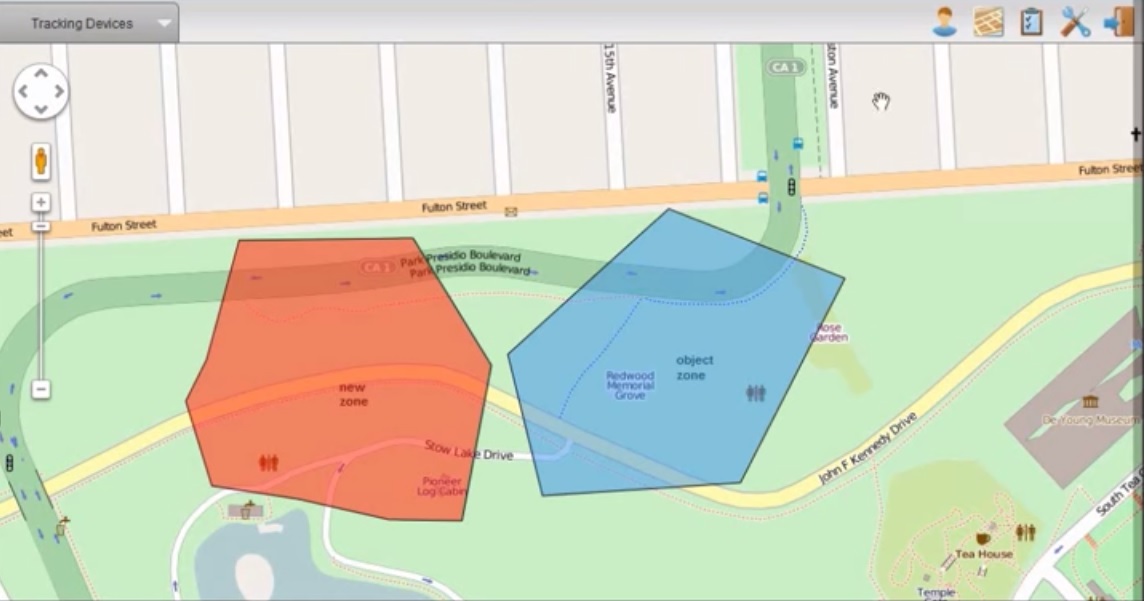
In MQTTg, by adding geolocation, information reaching subscribers can be filtered out by the broker to only fall within the subscriber's geofence. We can see an example of a geofence in Figure 1. As a green IoT example, take a smart city driving condition topic. By prescribing a geofence where driving conditions may not be adequate for a variety of reasons (weather, construction, or an accident for example), specific subscribers on a smart city topic like driving conditions would receive updates based on whether or not their geolocation in real time intersects with a polygon geofence where driving conditions may be abnormal. Other subscribers would receive different messages based on their driving routes throughout the city. We are also motivated by releases such as OpenHAB, an open-source home automation framework [20] and releases like OwnTracks, a private location diary system that allows users on iOS and Android to keep a location diary and share the information with family and friends [21], however both releases focus on Payload modifcation not modifying the protocol itself as we do here. Further use cases for MQTTg include:
-
•
Field team coordination
-
•
Search and rescue improvements
-
•
Advertising notifications to customers within specific ranges
-
•
Emergency notifications, such as inclement weather or road closures.
-
•
Taxi cab monitoring and deployment strategies
II Results
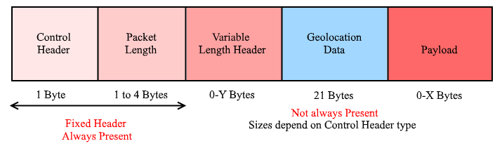
The basis of MQTTg is to leverage unused binary bit data within the protocol definition and, optionally, embedding geolocation data between the header and payload as shown in Figure 3. We can clearly see while comparing Figure 2 to Figure 3 where the changes have been made indicated in blue. We show details of the bytes of Geolocation data as shown in Figure 3 in Listing 1.
The major change to the packets themselves was the inclusion of the Geolocation Flag. The flag is sent in packets to the broker to notify the broker that they are sending geolocation data in the packet. The packets that are used to send geolocation information are given in Table I, derived from the original protocol implementation. In Listing 2, we see the updated C# code for MQTTnet packet deserializer for the PUBLISH/PUBLISHG packet. The isGeog Boolean passed is based on the packet type identified by the calling method. Based on this geolocation flag, we treat the PUBLISH/PUBLISHG packets differently.
| Packet | Description |
|---|---|
| PUBLISHG | Publish message |
| PUBACK | Publish acknowledgement |
| PUBREC | Publish received (assured delivery part 1) |
| PUBREL | Publish received (assured delivery part 2) |
| PUBCOMP | Publish received (assured delivery part 3) |
| SUBSCRIBE | client subscribe request |
| UNSUBSCRIBE | Unsubscribe request |
| PINGREQ | PING request |
| DISCONNECT | client is disconnecting |
From the Paho MQTTg implementation, Listing 3 gives the updated Java implementation for de-serializing MQTT packets which they call MqttWireMessage. For a PUBLISH packet, the Java client is normally setup to determine the topic when creating a new MqttPublish object. For a geolocation packet, it is setup to have the topic before the geolocation data. So, the code is modified to do as such if one is received. The Java client stores the geolocation data in big endian IEEE 754 format. The geolocation data is, however, encoded in little endian so the bytes need to be reversed to get the correct output for this data. To be consistent, we are adhering to the IEEE floating point representations everywhere.
For all packets mentioned in Table I, with the exception of PUBLISH, the rd bit of the fixed header is unused (reserved) in the original implementation in [22], so we can easily use it to indicate the presence of geolocation information. Figure 2 shown earlier and Figure 3 explain where the location data is in the packet.
The PUBLISH control packet needs a different implementation. Because the rd bit is already allocated for Quality of Service (QOS), and all other packets are also reserved for an existing use, we chose to implement a new control packet type. PUBLISHG (=0xF) is used as the flag type for geolocation data when it is to be sent. There are available command packet types within the MQTT standard and through are used.
We deem geolocation data as an optional attribute, as not all clients may wish to publish their geolocation data for security reasons. In our approach, geolocation data is not included in the packet payload, since not all packet types support a payload, thus rendering payloads not a viable option— especially for green IoT. Furthermore, we did not wish the broker to examine the payload of any packet, thus keeping our processing footprint low.
II-A Handling of packets
Packets that are received without geolocation data are handled via the original MQTTnet and Paho functions respectively. Packets that are received with geolocation are handled similarly but with a call to a last known location updating method— which stores the client’s unique and the location data into a Hashtable object designed to be compared against the geofence. If and only if they are a subscriber is the packet to be sent with geolocation data. We have elected to attach geolocation data from all packet types originating from the client to eliminate the need for specific packets carrying only geolocation data, and thus reducing network traffic as well.
II-B Geofencing
Creating the geofence code was a major part of MQTTg. The geofence filtering is only called when a packet is submitted to the broker as these packets are forwarded to subscribing clients.
Geofence data is presently submitted and cleared by a client to the broker using the MQTT SUBSCRIBE packet so that clients may individually submit geofences of interest. The broker maintains polygon data for each subscribing client. Polygons may be static in shape and location or dynamic and move with the last known location of the target.
Since the rd bit of the fixed header is unused, we are able to indicate whether or not the SUBSCRIBE packet contains GeoLocation data. If the data is present, the next bytes are read as before to get this information. The next step is to read the topic filter for the packet. In our implementation, we have created two new GeoLocation filters called ForwardInsideRadiusTopicFilter and ForwardOutsideRadiusTopicFilter respectively. With each one, the client can subscribe based on a topic, latitude, longitude, and radius to either receive PUBLISHG packets from within or outside of the area. To determine if a GeoLocation filter is present, the second bit in the QoS byte is used as the identifier. If the bit is present, the next byte read will determine which type of GeoLocation filter was passed and it will then proceed to read the radius, latitude, and longitude to create the filter. Our implementation still allows for a normal topic filter to be used.
II-C Android OS Application
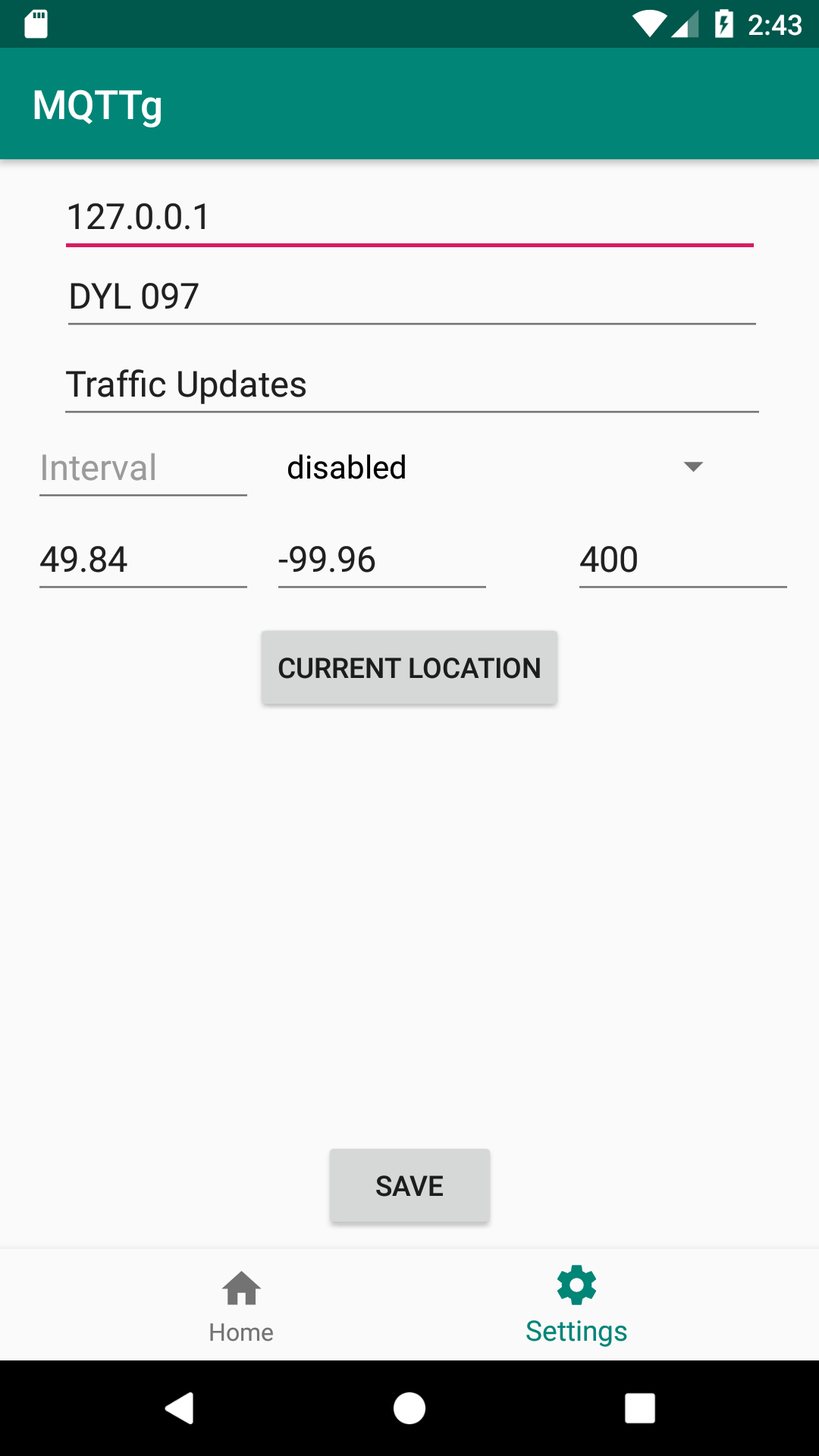
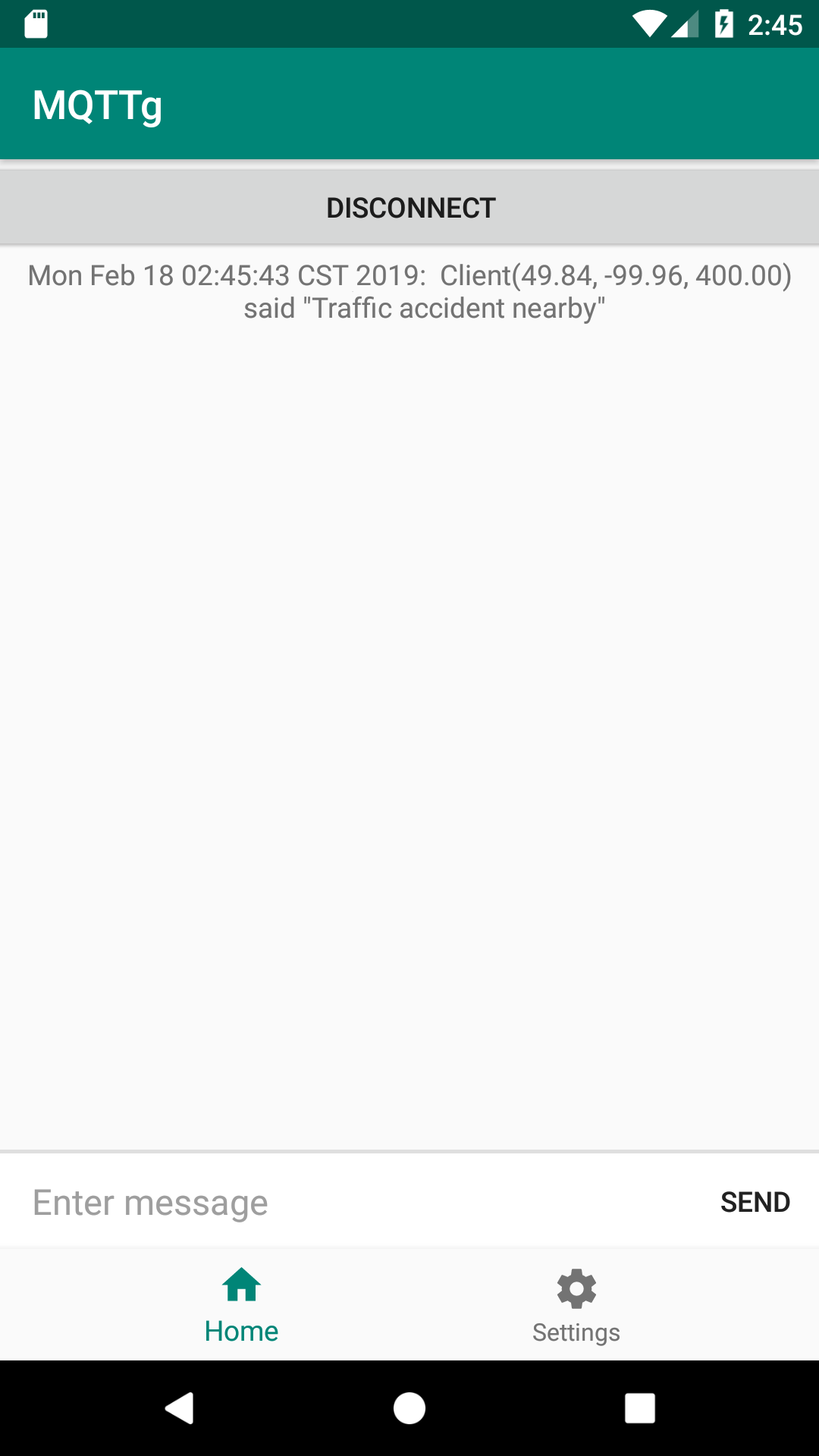
Figure 4 provides some snapshots of the current implementation of the Android OS Application for MQTTg. In Figure 4(a), a subscriber (client) can identify themselves on the network. Pressing the Current Location button will provide the application with the client's current geolocation data pulled from the OS. By not pressing Current Location, the given client acts in original MQTT form lacking any geolocation activity. The topic, say Traffic Updates, will subscribe the client to that topic for future updates, which will show in Figure 4(b). If an update is provided to the topic by a publishing client, all other clients within a geofence bounded area of the publisher's creation will receive the message. A client can subscribe to as many topics, with or without geolocation, as they choose. In Figure 4(b), all subscribed topic messages will be shown here. Topics where geolocation are shared will be specific to a given geofence so only matching geolocation data to a given geofence will show. These matches are determined by the broker based on the rules of the geofence from the subscriber. We expect to add separate layouts for a publisher scenario versus a subscriber scenario on the network.
III Experimental Results
To experiment with the accuracy of geolocation within the MQTTg Android application, we performed a series of experiments. First, a route was mapped within city limits using a well known geolocation user and service, Google Maps [23].
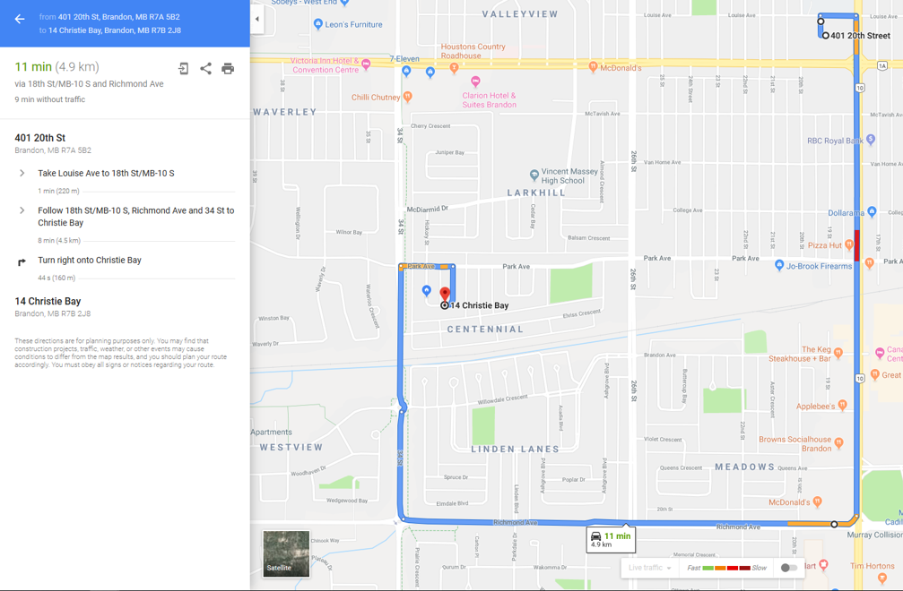
In Figure 5, we show a Google Maps screenshot of a mapped route from Brandon University to a residential area in Brandon, Manitoba, Canada. The total distance as shown is km. We then, did multiple trials driving the route with an Android Phone, running the MQTT client as described in section II-C with geolocation packets being sent every seconds sending all relevant geolocation data. Using the Distance measurements calculated by the Broker using geolocation information between packets received, we calculated a total distance traveled being km for all trials. This gives an accuracy rating for the geolocation data of . Since Google Maps data is only to a precision level of , it may very well be that we achieved a accuracy rating in our trials.
IV Future Work
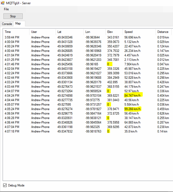
We are still finishing the final testing of MQTTg for the Android OS. In Figure 6, there were some anomalies both in Elevation and Speed as highlighted. We wish to troubleshoot these issues to see what the cause of this could be.
Applications of the Android client are plentiful but have some key uses in green IoT, natural disaster containment, and safety in this age of mobile devices and smart cities. We can also see some direct applications for visually impaired individuals trying to navigate smart cities [24]. Additionally, there is room to make the Android operating system application more visually appealing.
We have yet to deal with both security limitations of MQTT and Quality of Service (QoS) levels and how they will relate to MQTTg. The OASIS standard implemenation of MQTT strongly recommends a MQTT security solution using SSL/TLS [25]. However, this solution entails additional significant communication and computation overheads for certificate validation checks which may not be feasible in IoT solutions.
The QoS level is an agreement between the sender of a message and the receiver of a message that defines the guarantee of delivery for a specific message. There are QoS levels in MQTT that give clients the power to choose a level of service that matches their network reliability and application logic. Therefore, there still needs to be some connection between security, QoS and MQTTg. We are currently working on perhaps applying them together with differing levels of security depending on with QoS in being used. There is room and viability to use the bytes of information as shown in Figure 3 to help manage the QoS levels and security.
V Conclusion
In this paper we furthered some initial work on our protocol MQTTg aptly named for the addition of geolocation to the protocol. We were able to create an Android application using MQTTg. We also ran some experimental trials to test the accuracy of MQTTg on the Android OS with strong results. It is important to further this study on MQTTg as their is still both room for improvement as well as baselines needed for performance of the protocol under implementation loads.
References
- [1] A. Zanella, N. Bui, A. Castellani, L. Vangelista, and M. Zorzi, ``Internet of things for smart cities,'' IEEE Internet of Things journal, vol. 1, no. 1, pp. 22–32, 2014.
- [2] A. D. Dwivedi, P. Morawiecki, and G. Srivastava, ``Differential cryptanalysis of round-reduced speck suitable for internet of things devices,'' IEEE Access, 2019.
- [3] A. D. Dwivedi, G. Srivastava, S. Dhar, and R. Singh, ``A decentralized privacy-preserving healthcare blockchain for iot,'' Sensors, vol. 19, p. 326, 2019.
- [4] C. Perera, A. Zaslavsky, P. Christen, and D. Georgakopoulos, ``Sensing as a service model for smart cities supported by internet of things,'' Transactions on Emerging Telecommunications Technologies, vol. 25, no. 1, pp. 81–93, 2014.
- [5] E. J. Vergara, M. Prihodko, and S. Nadjm-Tehrani, ``Mobile location sharing: an energy consumption study,'' in Proceedings of the fourth international conference on Future energy systems. ACM, 2013, pp. 289–290.
- [6] R. A. Light, ``Mosquitto: server and client implementation of the mqtt protocol,'' Journal of Open Source Software, vol. 2, no. 13, 2017.
- [7] N. De Caro, W. Colitti, K. Steenhaut, G. Mangino, and G. Reali, ``Comparison of two lightweight protocols for smartphone-based sensing,'' in 2013 IEEE 20th Symposium on Communications and Vehicular Technology in the Benelux (SCVT). IEEE, 2013, pp. 1–6.
- [8] A. Larmo, A. Ratilainen, and J. Saarinen, ``Impact of coap and mqtt on nb-iot system performance,'' Sensors, vol. 19, no. 1, p. 7, 2019.
- [9] E. Nasr, E. Kfoury, and D. Khoury, ``A pervasive iot scheme to vehicle overspeed detection and reporting using mqtt protocol,'' in ICT for a Better Life and a Better World. Springer, 2019, pp. 19–34.
- [10] S. N. Firdous, Z. Baig, C. Valli, and A. Ibrahim, ``Modelling and evaluation of malicious attacks against the iot mqtt protocol,'' in 2017 IEEE International Conference on Internet of Things (iThings) and IEEE Green Computing and Communications (GreenCom) and IEEE Cyber, Physical and Social Computing (CPSCom) and IEEE Smart Data (SmartData), June 2017, pp. 748–755.
- [11] D. G. Roy, B. Mahato, D. De, and R. Buyya, ``Application-aware end-to-end delay and message loss estimation in internet of things (iot)—mqtt-sn protocols,'' Future Generation Computer Systems, vol. 89, pp. 300–316, 2018.
- [12] R. Bryce, T. Shaw, and G. Srivastava, ``Mqtt-g: A publish/subscribe protocol with geolocation,'' in 2018 41st International Conference on Telecommunications and Signal Processing (TSP). IEEE, 2018, pp. 1–4.
- [13] R. Bryce and G. Srivastava, ``The addition of geolocation to sensor networks,'' in ICSOFT. SciTePress, 2018, pp. 796–802.
- [14] O. Source, ``Mqttnet,'' https://github.com/chkr1011/MQTTnet, accessed: 2018-10-01.
- [15] G. Srivastava, A. Fisher, R. Bryce, and J. Crichigno, ``Green communication with geolocation,'' arXiv preprint arXiv:1811.09706, 2018.
- [16] O. Source, ``Mqtt documentation,'' http://http://mqtt.org/documentation, accessed: 2019-05-01.
- [17] D. Soni and A. Makwana, ``A survey on mqtt: a protocol of internet of things (iot),'' in International Conference On Telecommunication, Power Analysis And Computing Techniques (ICTPACT-2017), 2017.
- [18] ``The eclipse paho project,'' https://www.eclipse.org/paho/, accessed: 2018-10-01.
- [19] ``The wikipedia geofence,'' https://en.wikipedia.org/wiki/Geo-fence, accessed: 2019-02-28.
- [20] F. Heimgaertner, S. Hettich, O. Kohlbacher, and M. Menth, ``Scaling home automation to public buildings: A distributed multiuser setup for openhab 2,'' in 2017 Global Internet of Things Summit (GIoTS). IEEE, 2017, pp. 1–6.
- [21] ``Owntracks: Personal location diary,'' https://github.com/owntracks, accessed: 2019-05-01.
- [22] A. Stanford-Clark and U. Hunkeler, ``Mq telemetry transport (mqtt),'' Online]. http://mqtt. org. Accessed September, vol. 22, p. 2013, 1999.
- [23] G. Svennerberg, Beginning Google Maps API 3. Apress, 2010.
- [24] A. Al-Fuqaha, M. Guizani, M. Mohammadi, M. Aledhari, and M. Ayyash, ``Internet of things: A survey on enabling technologies, protocols, and applications,'' IEEE Communications Surveys & Tutorials, vol. 17, no. 4, pp. 2347–2376, 2015.
- [25] O. S. I. A. Errata, ``Mqtt version 3.1. 1 plus errata 01,'' 2015.