Geolocating Political Events in Text
Abstract
This work introduces a general method for automatically finding the locations where political events in text occurred. Using a novel set of 8,000 labeled sentences, I create a method to link automatically extracted events and locations in text. The model achieves human level performance on the annotation task and outperforms previous event geolocation systems. It can be applied to most event extraction systems across geographic contexts. I formalize the event–location linking task, describe the neural network model, describe the potential uses of such a system in political science, and demonstrate a workflow to answer an open question on the role of conventional military offensives in causing civilian casualties in the Syrian civil war.
1 Introduction
Researchers in social science, and especially in comparative politics and security studies, are increasingly turning toward micro-level data, with subnational variation at very fine resolutions becoming a major source of empirical puzzles and evidence in these fields. At the same time, text data is becoming one of the most important sources of new data in social science. I develop and describe a method that enables researchers to connect these two trends, automatically linking events extracted from text to the specific locations where they are reported to occur.
Specifically, I develop a method that, given a sentence and an event’s verb in the sentence, will return the place names from the sentence where the event took place. Formulated as a general task, this is an unsolved problem in both political science and computer science. Drawing on a set of 8,000 hand-labeled sentences, I train a recurrent neural network that draws on a rich set of linguistic features to label a sequence of text with labels for whether the word is a location word corresponding to a specified verb. Measured by token, the model produces precision and recall scores of over 0.83, compared with a rule-based model’s 0.25–0.29. A software implementation and example workflow is provided.
I provide an example application, creating a new dataset on the locations of military offensives in Syria and contributing to an ongoing debate in conflict studies on the causes of civilian casualties in civil war. The model is general enough for applied researchers to use in other contexts, including the study of protests, political mobilization, political violence, and electoral politics. The new shared dataset will enable other researchers in NLP to contribute to this task and the wider research project of better extracting political relationships from text.
2 Task and Formulation
Event–location linking sits within a larger set of techniques for extracting information on political events from text, including entity extraction and toponym resolution.
Event extraction is the process of recognizing defined event types in text (e.g. “attack” or “protest”) and extracting and classifying the actors involved in the events. Many approaches to this task exist in both political science and NLP, using both rule-based and machine learning coders (Schrodt, Davis, and Weddle 1994; O’Connor, Stewart, and Smith 2013; Schrodt, Beieler, and Idris 2014; Boschee et al. 2015; Beieler 2016; Beieler et al. 2016; Hanna 2017; Keith et al. 2017).
To be useful in subnational research, these events require information on the location where they occurred. A second related information extraction task is “geoparsing”, the process of recognizing place names in text (“toponym recognition”) and resolving them to their coordinates or gazetteer entry (“toponym resolution”). Some work on geoparsing, also referred to as “georeferencing” or “toponym resolution” exists (Leidner 2008; Hill 2009; Speriosu and Baldridge 2013; Berico Technologies, n.d.; D’Ignazio et al. 2014; Gritta et al. 2017; Halterman 2017; Avvenuti et al. 2018). Performing this task requires disambiguating place names using heuristics or a model (in a particular document, is “Prague” the capital of the Czech Republic or the town in Oklahoma?).
The task that this paper addresses sits between the two: given an extracted event in a sentence, which of place name is the location where the event occurred? Consider the following sentence as a running example:
After establishing a foothold in the northern Aleppo towns of Tadif and Al-Bab, the Turkish Army and allied Syrian rebels launched an offensive on its neighbouring town of Bza’a, a spokesperson for Ankara said today.
An event extraction system may identify events such an “establish foothold” event or a “launch offensive” event. A geoparser would be concerned with recognizing the place names in the text (“Aleppo”, “al-Bab”, “Bza’a”) and resolving them to their correct coordinates (made difficult by “Aleppo” being the governorate here, not the city). An event–location linking system of the kind introduced here would associate the “establish foothold” event with “al-Bab” and the “launch offensive” event with “Bza’a”.
The task can be formalized as follows. Consider a sentence of tokens. Given an event , the location where event occurred is defined as a set of tokens . For “establish a foothold”, .
Because a sentence can contain multiple events, the set of event locations and are not equivalent for . For “launch an offensive”, . can have zero elements, one, or several elements. Thus, for , as the “said” event is not associated with a specific place.
Each token is given a label , where
To make the estimation of tractable, I make several assumptions.
First, in order to condition on the event , I assume that the information provided by the verb of the event is sufficient.111By “verb” I mean the highest verb on the dependency tree that is uniquely part of event . In dictionary-based event coding methods, this is in practice the lexical “trigger” word for the event, though the event–location linking method is agnostic to how the event is coded. Thus, . This assumption, that events are “anchored” by a verb, is a common assumption in semantic role labeling, a closely related task to event–location linking (Palmer, Gildea, and Kingsbury 2005; White et al. 2016; Marcheggiani and Titov 2017).222Though consider the phrase “After the riots in Gujarat…”. This sentence reports a “riot” event but without a verb. These clausal mentions of events are rarely coded by event extraction systems, both because of difficulty in coding and because they often describe historical, rather than contemporary events, meaning the decision to require a verb has little practical difference.
Second, I assume that an adequate representation of each word is , where is a feature-making function that maps from a high dimensional one-hot vector to a lower dimensional dense encoding, drawing on the context of the word in the sentence. Applied to a sentence,
.
Thus,
Finally, I assume that the event location status of word is conditionally independent of other words’ labels after conditioning on the matrix of sentence context . Making this assumption greatly simplifies estimation, as the task of assigning labels can be decomposed into a set of independent tasks:
This assumption only carries costs if words’ labels affect each other through a mechanism outside of . The assumption seems warranted here, though, because of the binary nature of the classification task.333This conditional independence of labels assumption is generally not made in part of speech tagging, dependency parsing, or named entity recognition. In these tasks, each word can be assigned one of many possible labels, and past labels dramatically change label probabilities. (For example, if a word is predicted to have the part-of-speech label verb, the following word cannot be labeled be verb if the sentence is to be grammatical). These tasks required more sophisticated beam search or shift-reduce models (Goldberg 2017; Jurafsky and Martin 2018).
3 Previous work
Many existing open source geolocated event datasets, including GDELT and Phoenix, make no effort to explicitly link events and locations, simply returning a top location from a sentence, without using information on the extracted event to inform the geolocation step, which has also been used in NLP (Aone and Ramos-Santacruz 2000).444ICEWS uses a proprietary system to link events and locations that is not documented or accessible to researchers (Lautenschlager, Starz, and Warfield 2017). Two recently proposed models do attempt to find events’ locations, however (Imani et al. 2017; Lee, Liu, and Ward 2018). Both make a major simplifying assumption, that returning the correct location does not depend on conditioning on an event of interest: . The advantage of this assumption is that each model can use a simple bag-of-words model that does not account for word order or grammatical information, but it means that the labels they produce for text with multiple events and locations will be incorrect for at least some events.
Imani et al. (2017) propose a method for finding the “primary focus location” of a story, which they define as “the place of occurrence of the event” (1956). Their method makes the simplifying assumption that documents have one single, fixed “focus location” that is invariant to different potential events in the document. During training and testing, they eliminate all documents with multiple events and multiple “focus locations.” Their model discards word order information, representing each sentence as a weighted average of pretrained word embedding, and use this feature vector as an input to an SVM that predicts which sentence contains the “focus location.” Then, the most frequent place name in the “focus sentence” is the “focus location.”
Lee, Liu, and Ward (2018) also make several other restrictive assumptions. The implementation of their model is only able to located events to the governorate/province (ADM1) level, and finds locations based on a dictionary search of known place names: for any that is not present in the list of place names. This limits the maximum accuracy to a relatively coarse level, and prevents the method from recognizing places that are not on a relatively short list of place names, which is unlikely to contain more rural or obscure places. Any findings will be biased toward more populated areas, a known problem in political violence research (Kalyvas 2004; Douglass and Harkness 2018). Second, they learn a different for different event types, requiring documents to be classified into event types before geolocation, requiring a training round with labeled data for each event type and preventing parameters from being shared across models for different event types.
Other work, in natural language processing, is related but not directly applicable. Existing semantic role labeling and event extraction tasks sometimes include location slots for events (e.g. Doddington et al. 2004), but none are precisely suited to a general system focused on political events. FrameNet (Baker, Fillmore, and Lowe 1998) events have highly specific slots for different event types, while PropBank (Palmer, Gildea, and Kingsbury 2005) defines locations in a broad way that includes non-tangible places (“keep in our thoughts). A more specific literature on spatial information in text also exists. For instance, the SpaceEval task (Pustejovsky et al. 2015) provides a comprehensive ontology of spatial relations in text. These relations are focused on entities, rather than events, and provide more detail than is desirable in a application-oriented model. The task as I have formulated it thus seeks to be much more general, in that it attempts to locate any type of event, but also more limited, in that it focuses solely on where events occurred, rather than a larger set of spatial relations between entities.
The closest existing work in NLP is Chung et al. (2017). They attempt to find both explicit and implicit event locations in text, using a corpus of 48 documents. They use a rule-based system built on top of word embedding similarity and existing gold standard OntoNotes grammatical information to infer the locations of events. While the system shows good performance and is able to geolocate events even when the location information is not provided directly in the sentence, it relies on access to gold standard dependency parse information in a single domain of text.
4 Data
Implementing an automated procedure for geolocating events required collecting a novel set of data. I created a new dataset of around 8,000 labeled sentences in English, each of which is annotated with an event verb and its corresponding location or locations (if any).555The data and related materials are available at https://github.com/ahalterman/event_location Sentences may have multiple annotations corresponding to different verbs of interest. Sentences were selected from a range of sources to maximize the applicability of models trained on the data. The text is drawn from a wide range of sources, including an assortment of international papers and news wires (50%), a selection of local English-language media from Syria (35%), and non-news sources such as Wikipedia, atrocity monitoring reports, or press releases (15%). Annotation consisted of selecting a verb, either using a dictionary of specified verbs that focused on territorial capture-type events, or using verbs automatically detected using spaCy with the exception of “to be” to ensure the generalizability of the data. The verbs were not filtered through an event extraction system to keep the set as general as possible. Annotators then selected the tokens representing the event locations for the verb, if any. Around 5,000 annotations were provided by a research assistant and 5,000 were annotated by me. After annotation, each sentence looks something like the following:
He was speaking a day after Ankara [launched verb] an offensive in the Syrian towns of [Jarablus event_loc] and [Kobane event_loc].
Annotations consist of the most specific named place or places, in contrast to previous approaches that were limited to the city (Imani et al. 2017) or the governorate/province (Lee, Liu, and Ward 2018). Events can have no reported event, a single event with multiple location tokens (“New York”), or multiple event locations (“New York and Washington”). The modal number of locations is one (49%), followed by no locations (47%), and multiple locations comprise the remainder (3%). Most locations consist of a single token (69%), 19% are two tokens, and the remaining 12% are three or more. Sentences have a large number of verbs, and thus a potentially large number of events. The average number of verbs per sentences is 3.6, after excluding auxiliary verbs. Only 9% contain a single non-auxiliary verb, and 21% contain five or more verbs.
5 Model
I develop two neural network models to perform the event–location linking task. I also describe a rule-based baseline model, along with existing models from the literature as comparisons.
I use as a baseline model a rule-based event–location linker that locates an event to the automatically recognized location word in closest linear proximity to the event’s verb. This model provides per-event locations, unlike existing models, and incorporates a minimal sentence distance feature.
Neural networks are now the dominant approach to most of natural language processing (Goldberg 2017; Jurafsky and Martin 2018) so they are the models adopted here. Determining the event locations in a sentence using neural networks requires a language representation that preserves word order and useful grammatical information in the sentence. I preprocess the sentence by representing each word as a concatenation of the following information generated by the spaCy NLP library (Honnibal and Montani 2017) pretrained GloVe vector, dependency label, named entity label, part-of-speech tag, an indicator for whether the word is the event verb of interest, the (signed) distance between the word and the indicated verb, and the distance between the verb and the token on the dependency tree. I use the same features for two neural network models. Both of the neural net models below look at a token, along with its context, and make a binary prediction for whether the token is an event location for the specified event.
The first neural network model uses a series of stacked convolutional layers. Some research suggests that convolutional neural networks (CNNs) perform equivalently to recurrent neural networks on sequence modeling tasks with lower computational cost (Bai, Kolter, and Koltun 2018). Each convolution looks at three inputs (words) at once, and slides down the sentence one token at a time. By stacking layers on top of each other, the elements of the final output of the final convolutional layer includes information from across the sentence. I use residual layers (He et al. 2016), which are now the state-of-the-art on image recognition tasks. Residual layers help prevent the “vanishing/exploding gradient” problem that deep neural networks often encounter, and speed the model’s fitting. A CNN with residual layers empirically outperformed a model of similar depth and structure without residual blocks, and is theoretically justified because they allow me to train a deeper network with lower demands on my limited pool of input data. After training and evaluating several dozen models, the best performing CNN model used 7 residual layers with 64 hidden nodes in each, followed by two dense layers with 512 nodes each with a dropout of 0.4 and ReLU activation.
The second class models is recurrent neural network (RNN), specifically a long short-term memory (LSTM) network (Hochreiter and Schmidhuber 1997), which explicitly models the sequential nature of their input data (see Figure 1). RNNs are the dominant approach to sequence modeling tasks in natural language processing and achieve state-of-the-art results on many tasks (Goldberg 2017). LSTMs store an internal state at each step of the input data in the form of a hidden vector. In contrast to vanilla RNNs, LSTMs can learn when to add information from their current input step to the hidden state and when to “forget” information from the hidden state. In theory, this allows LSTMs to learn much longer relationships than they would otherwise be able to. Bidirectional LSTMs are the standard extension to LSTMs when the model has access to the “future”, and compute two state vectors for each input step: one from the left and one from the right. These two vectors are concatenated and used as input to the rest of the model. The best LSTM network I trained used a bidirectional LSTM with a hidden size of 128 and 0.2 recurrent dropout, followed by a dense layer of 128 with ReLu and 0.5 dropout, and a final binary output node for each time step.

All models were trained in Keras with a Tensorflow backend on a multicore CPU.666The models are are available in Mordecai, an open-source document geoparser: https://github.com/openeventdata/mordecai
In addition to my baseline and neural network models, I also perform comparisons with three existing approaches. First, PropBank is included as a point of comparison. The PropBank includes an ArgM-LOC label in Palmer, Gildea, and Kingsbury (2005). The framing of the location task in PropBank is quite different than the generalized event–location linking task I introduce, as I describe above, but the performance of the baseline model in Palmer, Gildea, and Kingsbury (2005) on the task serves as another baseline. Second, I modify Profile (Imani et al. 2017) to accept new text and compare its performance on my new labeled data. Third, I report the best-case values from Chung et al. (2017).
Finally, I estimate the expected real-world performance of a human annotator by comparing an annotator’s performance to a “gold standard” set of annotations. To produce the gold set, I randomly selected sentences annotated by the research assistant. I reannotated them, skipping ambiguous sentences. Sentences with the same annotations in the two periods were included in the gold evaluation set totalling 500 sentences. I could then compare RA performance with a “gold” measure of performance.
6 Evaluation
I evaluate these and several existing models on the task and the English-language dataset I introduce. To evaluate the performance of each model, I assess accuracy on both a per-token and per-sentence basis. For per-token accuracy, I take a common approach of calculating the precision and recall in the evaluation sentences. Each model is evaluated on how well it can can produce, for each token whether is an event location for event . This evaluation approach allows “partial credit” for models that that may miss or falsely include a single token and is a common approach to evaluating sequence labeling tasks (Strötgen and Gertz 2016). I also include a second measure that more closely matches real-word accuracy. This measure reports the proportion of documents for which the annotation produced by the method exactly matches the correct label for each token in the document: . The results for the word distance baseline measure, existing approaches, expected human performance, and the two models I develop are reported in Table 1.777Results are not reported for the method developed by Lee, Liu, and Ward (2018). Unlike the other approaches, this method only geolocates to the province/ADM1 level, which is much coarser than these other techniques. It can only find place names on a provided whitelist of names, and models are customized to specific countries and events, making it unsuitable for this more general task of linking arbitrary locations and events. Finally, the replication code provided is not easily applicable to new datasets, only to run the initial experiments.
| Model | Prec | Rec | F1 | Sentence |
| Baseline | 0.29 | 0.25 | 0.27 | 0.28 |
| Profile | 0.54 | 0.29 | 0.37 | 0.51 |
| PropBank888These numbers are performance on the PropBank dataset, not on the dataset I create. | 0.61 | 0.39 | 0.47 | - |
| CNN | 0.70 | 0.54 | 0.61 | - |
| Chung et al.999Performance of Chung et al’s model on their corpus of 48 OntoNotes documents. The maximum values achieved for precision, recall, and F1 across their models are reported here. Note that the results on my model report per-token precision and recall, while they report per-location precision and recall. | 0.74 | 0.62 | 0.62 | - |
| Annotator | 0.88 | 0.65 | 0.74 | 0.73 |
| LSTM | 0.85 | 0.83 | 0.84 | 0.77 |
The word distance baseline model, which locates an event to the closest recognized place name in the text, performs the worst of any model, perhaps due to the unreliability of the distance heuristic itself, errors in the NER system, and the model missing places when multiple correct locations are present.
Profile (Imani et al. 2017) performs next worst, with an token-level F1 score of 0.37. The model is unable to to vary its location prediction by event type, meaning that it will correctly locate at best one event’s location in a multi-event, multi-location sentence. Profile also returns only one location per sentence, lowering its accuracy on events that occur in multiple locations. Profile’s intended use case is on longer pieces of text: its poor performance on this task should be taken only as an indication of its ability to geolocate events in text, not on its ability to find the primary “focus” (D’Ignazio et al. 2014) location of a piece of text.
PropBank is included as a point of comparison. The PropBank values are reported for the ArgM-LOC label in Palmer, Gildea, and Kingsbury (2005). The framing of the location task in PropBank is quite different than the generalized event–location linking task I introduce, as I describe above. The reported F1 score of 0.47 can be taken as a reasonable baseline performance on an event–location linking task. Chung et al’s (2017) accuracy on their dataset and version of the task is the best of any prior model.
The LSTM model performs much better than the CNN model, even after extensive tuning for the CNN model. Inspection of the CNN model’s output (not included) indicates that the model seems to not learn long-distance relationships well, and failed to appropriately change probability weights when the verb of interest changed. The LSTM model, in contrast, performs very well and is very sensitive to changes in the input verb: the same sentence with two different flagged verbs of interest will produce quite different results for those events’ location. The LSTM and CNN are comparable in training time.
Notably, the LSTM also outperforms an estimate of expected human performance on the event–location linking task. While humans are able to pick up on nuance and deal with grammatical complexity that machines still cannot handle, humans are also unsuited to the tedium of labeling thousands of sentences and may be susceptible to drift in their definitions or understanding of the task. Not only is the automated method vastly cheaper and faster than a human process, it does so with accuracy at least as good.
6.1 Ablation test
Figure 2 shows the results of an ablation process on the best performing LSTM model, revealing that some features are more important than others across several random partitions and retrainings of the model.
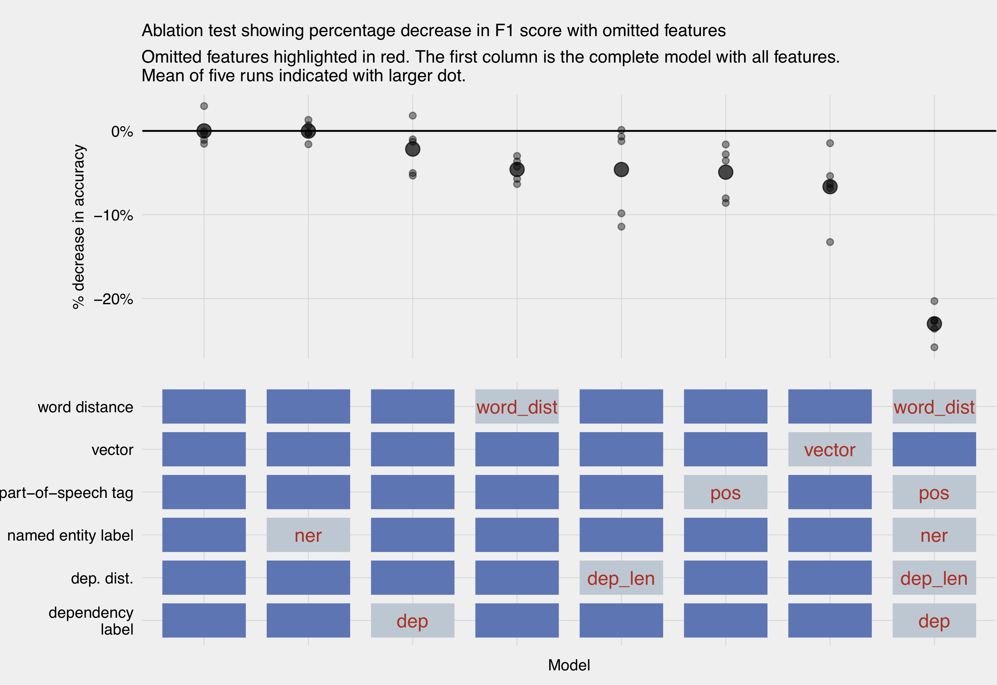
The ablation test reveals several interesting findings. First, the variability in feature importance across different train-test splits of the data prevents overly strong claims. With that in mind, the named entity label returned by spaCy would seem to be a useful feature in a task that requires picking one of potentially several place names. In fact, removing it leaves the accuracy unchanged, perhaps because the labeled data skews toward Arabic place names, which spaCy’s model struggles to recover. The two distance features, one encoding distance from each word to the verb of interest and the other encoding the length of the shortest dependency path between them, both seem marginally helpful. Surprisingly, the part-of-speech feature is more useful than the dependency label. This may be because the tree structure of the dependency parse is not being incorporated, only its labels. Finally, the pretrained GloVe embedding feature is helpful (second to the right column), but it is by no means sufficient on its own (rightmost column). While some of the literature on neural networks for NLP simply starts from pretrained word or character embeddings and learns useful representations from those, these results indicate that wider feature inclusion is very helpful for the model’s accuracy. The result is not driven solely by place names being out-of-vocabulary, as GloVe contains embeddings for 78% of the place names in the corpus.
Qualitative inspection of miscoded sentences also reveals that the model often fails to select the more specific location when one is available. Performing the geoparsing step first, and then incorporating that information into the event linking step could reduce this mode of failure. Future work could also replace categorical features, such as POS and dependency labels, with embeddings (see, e.g. Nguyen and Grishman 2015).
7 Application: Geolocating offensives in Syria
To demonstrate the usefulness of this approach, I use it to create a dataset of Syrian military offensives in 2016 by automatically coding military offensive events from text and geolocating them.
I collected 15,000 news stories on Syria covering 2016 from four sources: Al-Masdar news, Middle East Eye, Ara News, and news put out by the opposition National Coalition. To recognize the events themselves in the text, I created a one-off event coder that performs a dependency parse of the documents in the corpus and compares different grammatical parts of the sentence with a hand-specified set of terms to describe military offensives.
After recognizing an event in the text, I then use my event geoparsing method to find the location(s) in the text linked to the event’s verb. In order to produce final usable event data, I also perform the final step of resolving the event location or locations to their geographical coordinates. To do so I use the Mordecai text geoparser (Halterman 2017), which uses a neural network trained on several thousand gold-standard resolved place names to infer the country of a location mention, then performs a fuzzy-string search over the Geonames gazetteer (Wick and Boutreux 2011) and selects the best location among the locations returned from the search.
When combined with geolocated data on civilian deaths in Syria (Halterman 2018), the geolocated offensives allow us to determine that around 7% of civilian deaths in Syria occurred within one day and 1 kilometer of an announced military operation. This new dataset contributes to a growing literature on violence against civilians in civil war, showing that even in a conventional civil war like Syria’s, only a relatively small number of casualties are plausibly related to collateral damage from military operations. Figure 3 shows the geographic distribution of new offensives. This ability to create a dataset of when and where conventional fighting is occurring paves the way for better understanding of the patterns of violence against civilians in civil wars.

8 Conclusion
This paper introduces a state-of-the-art technique for linking events and locations in text with performance as good as humans. It proposes a new conceptualization of this task, focusing more on broad applicability than previous approaches in natural language processing, but more carefully accounting for grammar and the potential multiplicity of events than previous work in political science. It introduces a new labeled corpus of events and their locations, making the task accessible to other NLP researchers. The trained model achieves an F1 score of 0.82, making it accurate enough for researchers to begin to use.
In the social sciences, the availability of a model that can link events and locations in text should greatly increase the utility of event-type data for subnational researchers. Event data research on police violence in the United States (Keith et al. 2017), protest mobilization (Hanna 2017), political violence (Hammond and Weidmann 2014), and instability forecasting (Ward et al. 2013) could all be greatly improved by better techniques for automatically geolocating events. Researchers’ understandings of many of these social phenomena are limited by the availability of very fine-grained geographic data.
Future NLP work could improve accuracy by integrating the “toponym resolution” and event–location linking steps to improve accuracy, and could extend the model beyond a single sentence to increase the range of event types that the method can be applied to.
More broadly, this work builds on a growing body of research at the intersection of NLP and social science that attempts to extract information from text, rather than summarizing or categorizing documents. Text also holds a great deal of factual information and new techniques are needed to allow researchers to extract political information from text. The technique introduced here will improve researchers’ ability to incorporate information extracted from text into research studies that rely on geographically fine-grained data.
9 Acknowledgements
For valuable feedback on stages of this paper, I thank John Beieler, Fotini Christia, In Song Kim, Rich Nielsen, David Smith, Brandon Stewart, Rachel Tecott, and two very helpful anonymous reviewers. Emily Young provided excellent assistance in annotating training data. I gratefully acknowledge the support of a National Science Foundation Graduate Research Fellowship. For support in developing Mordecai (https://github.com/openeventdata/mordecai) and for creating annotated text data, I thank the National Science Foundation under award number SBE-SMA-1539302, the Defense Advanced Research Project Agency’s XDATA program, and the U.S. Army Research Laboratory and the U.S. Army Research Office through the Minerva Initiative under grant number W911NF-13-0332. Any opinions, findings, and conclusions or recommendations expressed in this material are those of the author and do not necessarily reflect the views of the National Science Foundation or the Department of Defense.
10 References
Aone, Chinatsu, and Mila Ramos-Santacruz. 2000. “REES: A Large-Scale Relation and Event Extraction System.” In Proceedings of the Sixth Conference on Applied Natural Language Processing, 76–83. Association for Computational Linguistics.
Avvenuti, Marco, Stefano Cresci, Leonardo Nizzoli, and Maurizio Tesconi. 2018. “GSP (Geo-Semantic-Parsing): Geoparsing and Geotagging with Machine Learning on Top of Linked Data.” Extended Semantic Web Conference (ESWC).
Bai, Shaojie, J. Zico Kolter, and Vladlen Koltun. 2018. “An Empirical Evaluation of Generic Convolutional and Recurrent Networks for Sequence Modeling.” arXiv Preprint arXiv:1803.01271.
Baker, Collin F, Charles J Fillmore, and John B Lowe. 1998. “The Berkeley FrameNet Project.” In Proceedings of the 17th International Conference on Computational Linguistics-Volume 1, 86–90. Association for Computational Linguistics.
Beieler, John. 2016. “Generating Politically-Relevant Event Data.” CoRR. http://arxiv.org/abs/1609.06239.
Beieler, John, Patrick T Brandt, Andrew Halterman, Erin Simpson, and Philip A Schrodt. 2016. “Generating Political Event Data in Near Real Time: Opportunities and Challenges.” In Data Analytics in Social Science, Government, and Industry, edited by R. Michael Alvarez. Cambridge University Press.
Berico Technologies. n.d. “CLAVIN: Cartographic Location and Vicinity Indexer.”
Boschee, Elizabeth, Jennifer Lautenschlager, Sean O’Brien, Stephen M Shellman, James Starz, and Michael D Ward. 2015. “ICEWS Coded Event Data.” In Harvard Dataverse, V9, http://dx.doi.org/10.7910/DVN/28075.
Chung, Jin-Woo, Wonsuk Yang, Jinseon You, and Jong C Park. 2017. “Inferring Implicit Event Locations from Context with Distributional Similarities.” In IJCAI, 979–85.
Doddington, George R, Alexis Mitchell, Mark A Przybocki, Lance A Ramshaw, Stephanie Strassel, and Ralph M Weischedel. 2004. “The Automatic Content Extraction (ACE) Program-Tasks, Data, and Evaluation.” In LREC, 2:1.
Douglass, Rex W, and Kristen A Harkness. 2018. “Measuring the Landscape of Civil War: Evaluating Geographic Coding Decisions with Historic Data from the Mau Mau Rebellion.” Journal of Peace Research.
D’Ignazio, Catherine, Rahul Bhargava, Ethan Zuckerman, and Luisa Beck. 2014. “CLIFF-CLAVIN: Determining Geographic Focus for News.” NewsKDD: Data Science for News Publishing, at KDD 2014.
Goldberg, Yoav. 2017. Neural Network Methods for Natural Language Processing. Synthesis Lectures on Human Language Technologies. Morgan & Claypool Publishers.
Gritta, Milan, Mohammad Taher Pilehvar, Nut Limsopatham, and Nigel Collier. 2017. “What’s Missing in Geographical Parsing?” Language Resources and Evaluation. Springer, 1–21.
Halterman, Andrew. 2017. “Mordecai: Full Text Geoparsing and Event Geocoding.” The Journal of Open Source Software 2 (9). doi:10.21105/joss.00091.
———. 2018. “Violence Against Civilians in Syria’s Civil War.” MIT Political Science Department Research Paper.
Hammond, Jesse, and Nils B Weidmann. 2014. “Using Machine-Coded Event Data for the Micro-Level Study of Political Violence.” Research & Politics 1 (2).
Hanna, Alex. 2017. “MPEDS: Automating the Generation of Protest Event Data.” SocArXiv Https://Osf. Io/Preprints/Socarxiv/Xuqmv.
He, Kaiming, Xiangyu Zhang, Shaoqing Ren, and Jian Sun. 2016. “Deep Residual Learning for Image Recognition.” In Proceedings of the Ieee Conference on Computer Vision and Pattern Recognition, 770–78.
Hill, Linda L. 2009. Georeferencing: The Geographic Associations of Information. MIT Press.
Hochreiter, Sepp, and Jürgen Schmidhuber. 1997. “Long Short-Term Memory.” Neural Computation 9 (8). MIT Press: 1735–80.
Honnibal, Matthew, and Ines Montani. 2017. “SpaCy 2: Natural Language Understanding with Bloom Embeddings, Convolutional Neural Networks and Incremental Parsing.” To Appear.
Imani, Maryam Bahojb, Swarup Chandra, Samuel Ma, Latifur Khan, and Bhavani Thuraisingham. 2017. “Focus Location Extraction from Political News Reports with Bias Correction.” In Big Data (Big Data), 2017 IEEE International Conference on, 1956–64. IEEE.
Jurafsky, Dan, and James H Martin. 2018. Speech and Language Processing. 3rd ed. draft. draft: https://web.stanford.edu/ jurafsky/slp3/.
Kalyvas, Stathis N. 2004. “The Urban Bias in Research on Civil Wars.” Security Studies 13 (3). Taylor & Francis: 160–90.
Keith, Katherine A, Abram Handler, Michael Pinkham, Cara Magliozzi, Joshua McDuffie, and Brendan O’Connor. 2017. “Identifying Civilians Killed by Police with Distantly Supervised Entity-Event Extraction.” arXiv Preprint arXiv:1707.07086.
Lautenschlager, Jennifer, James Starz, and Ian Warfield. 2017. “A Statistical Approach to the Subnational Geolocation of Event Data.” In Advances in Cross-Cultural Decision Making, 333–43. Springer.
Lee, Sophie J, Howard Liu, and Michael D Ward. 2018. “Lost in Space: Geolocation in Event Data.” Political Science Research and Methods, 1–18.
Leidner, Jochen L. 2008. Toponym Resolution in Text: Annotation, Evaluation and Applications of Spatial Grounding of Place Names. Universal-Publishers.
Marcheggiani, Diego, and Ivan Titov. 2017. “Encoding Sentences with Graph Convolutional Networks for Semantic Role Labeling.” arXiv Preprint arXiv:1703.04826.
Nguyen, Thien Huu, and Ralph Grishman. 2015. “Relation Extraction: Perspective from Convolutional Neural Networks.” In Proceedings of the 1st Workshop on Vector Space Modeling for Natural Language Processing, 39–48.
O’Connor, Brendan, Brandon Stewart, and Noah A Smith. 2013. “Learning to Extract International Relations from Political Context.” Proceedings of the 51st Annual Meeting of the Association for Computational Linguistics (Volume 1: Long Papers) Vol. 1.
Palmer, Martha, Daniel Gildea, and Paul Kingsbury. 2005. “The Proposition Bank: An Annotated Corpus of Semantic Roles.” Computational Linguistics 31 (1). MIT Press: 71–106.
Pustejovsky, James, Parisa Kordjamshidi, Marie-Francine Moens, Aaron Levine, Seth Dworman, and Zachary Yocum. 2015. “SemEval-2015 Task 8: SpaceEval.” In Proceedings of the 9th International Workshop on Semantic Evaluation (Semeval 2015), 884–94.
Schrodt, Philip A, John Beieler, and Muhammed Idris. 2014. “Three’s a Charm?: Open Event Data Coding with EL:DIABLO, PETRARCH, and the Open Event Data Alliance.”
Schrodt, Philip A, Shannon G Davis, and Judith L Weddle. 1994. “Political Science: KEDS—a Program for the Machine Coding of Event Data.” Social Science Computer Review 12 (4): 561–87.
Speriosu, Michael, and Jason Baldridge. 2013. “Text-Driven Toponym Resolution Using Indirect Supervision.” In ACL (1), 1466–76.
Strötgen, Jannik, and Michael Gertz. 2016. “Domain-Sensitive Temporal Tagging.” Synthesis Lectures on Human Language Technologies 9 (3). Morgan & Claypool Publishers: 1–151.
Ward, Michael D, Nils W Metternich, Cassy L Dorff, Max Gallop, Florian M Hollenbach, Anna Schultz, and Simon Weschle. 2013. “Learning from the Past and Stepping into the Future: Toward a New Generation of Conflict Prediction.” International Studies Review 15 (4): 473–90.
White, Aaron Steven, Drew Reisinger, Keisuke Sakaguchi, Tim Vieira, Sheng Zhang, Rachel Rudinger, Kyle Rawlins, and Benjamin Van Durme. 2016. “Universal Decompositional Semantics on Universal Dependencies.” In Proceedings of the 2016 Conference on Empirical Methods in Natural Language Processing, 1713–23. Austin, Texas: Association for Computational Linguistics.
Wick, Marc, and C Boutreux. 2011. “GeoNames.” GeoNames Geographical Database.