Vladimir Ignatiev, Alexey Trekin, Viktor Lobachev, Georgy Potapov, Evgeny Burnaev
11institutetext: Skolkovo institute of Science and technology, Moscow, Nobel st. 1, Russia,
11email: aeronetlab@skoltech.ru,
WWW home page:
http://crei.skoltech.ru/cdise/aeronet-lab/
Targeted change detection in remote sensing images
Abstract
Recent developments in the remote sensing systems and image processing made it possible to propose a new method of the object classification and detection of the specific changes in the series of satellite Earth images (so called targeted change detection). In this paper we propose a formal problem statement that allows to use effectively the deep learning approach to analyze time-dependent series of remote sensing images. We also introduce a new framework for the development of deep learning models for targeted change detection and demonstrate some cases of business applications it can be used for.
Keywords:
remote sensing, change detection, satellite imagery, computer vision, deep learning1 Problem overview
Earth observation systems have been developing during the last decades in terms of quality of the imagery and frequency of the imaging toth . However, until now the daily basis imagery wasn’t available for any location or area of interest. Each satellites and UAV systems have their own limitations - viz. number of satellites, weather and daylight for optical systems, vegetation for SAR systems, not to say the commercial ones. That lead the remote sensing industry to the situation where the amount of the data and the proclaimed frequency of the repeating imaging could have given us full daily coverage of the earth surface by the high-resolution imagery planet , but in the reality it turns out to be composed of the diverse, inconsistent and often incomplete data. And yet that business and technology trend raise the issues how all this daily imagery can be targeted to the specific needs and used in a various types of applications. The technical issues that can be raised following these business needs are:
- •
-
•
detection of changes in the time series of imagery and in a very short time spans to provide near real time valuable information related to the objects of interest. As the traditional approaches fail to make this massive dataflow a reliable source of the useful answers we should propose the new machine learning approaches that can handle it and provide the automated analysis that can compete to the human one by accuracy
The business needs lead to the concept of the targeted change detection (TCD) that is consolidated detection and classification of the changes in order to obtain only the interesting for the problem (target) changes rather than all the changes in general fernandez ; ye .
Our motivation in this paper is to build a general description of change detection (CD) problem taking into account characteristics of input data - series of remote sensing (RS) images - and information about “targets” obtained from classification of specific business applications of the respective territories such as “transportation & logistic”, “residential areas”, “building & construction” etc. Having formalized problem statement it is possible to develop overall framework that will reduce costs and simplify stages of collecting data, model construction and integration in workflow of business solutions.
1.1 Business applications of CD
Commercial services producing analytics based on series of multitemporal remote sensing images begin occupying significant share in such market areas as smart farming gamaya ; digitalglobe ; e-farming , monitoring of security zones of linear objects that have enormous transport network I-Cubed ; SIC ; orbilateye , monitoring of protected areas sovzond ; unmanned_systems ; zala , assessment of damage caused by natural and man-made disasters , analytical solutions for consulting agencies in geo-marketing rilos ; GIM .
Our survey of the commercial solutions based on analysis of RS images reveals the following problems:
-
•
only a number of applications have algorithmic solutions;
-
•
most of solutions do not have enough accuracy;
-
•
the plenty of problems do not have any reliable solutions;
-
•
companies are in search of new frameworks that will anticipate their risks or will make precise and timely estimation of losses.
It is obvious that each of use cases has its own demands and requirements to the changes that should be detected. For example, if one is going to monitor security zones of pipelines, he should find out the list of targets, changes of which will be detected. Each target means a specific type of objects that has the characteristic linear size and this value defines the spatial resolution of RS images to be used. Most of real business applications requires to process with RS images of high and very high spatial resolution from 5 cm/pixel to 10 m/pixel.
1.2 RS datasets available for CD algorithms
The idea of making general framework providing development of robust algorithms for detecting changes for the specific applied problem requires building representative datasets. There are scarce datasets for change detection on RS images nowadays AICD ; SARcdds ; GEEds ; cdnet . Only few of existing datasets can be implemented within the framework of targeted change detection AICD ; cdnet . Most of them have not enough coverage or time spread to learn and test algorithms using modern techniques of machine learning and deep learning. So the one of the challenges of our work is to collect and build a number of datasets dedicated to the task of targeted CD.
1.3 Current methods and algorithms
Solutions proposed in the latest papers could be divided into several groups according to the used models and algorithms, to market domains and to RS images in use. Traditional methods of change detection by series of satellite images are typically limited in several aspects:
-
•
using just two images for justification with ground truth;
-
•
do not take into account usability of changes in specific use case;
-
•
only empirical approaches for selection of the appropriate RS images for real applications;
-
•
no automated end-to-end solutions for business cases.
One of the first applied research in this area was conducted by W.Roper and S.Dutta Roper . They made an attempt to understand which kind of sensor system aerial or satellite is better in a sense of probability of detection unauthorized intrusion onto a pipeline right-of-way. The main conclusion of this work is that one should use aerial imagery when the imaging frequency is lower than once per month, but starting from once per day imaging frequency - probability of change detection with satellite imagery is higher. There were used standard algorithms of classification built-in such software packages as ENVI ENVI .
The future works were focused on improving change detection algorithms themselves, but the idea of targeted CD were pushed into the background. So, the best classical approaches are methods based on anomaly detection framework on time series of multispectral low-resolution satellite images and so called spectral indices Cai2015 , methods based on Markov Random Fields and global optimization on graphs Vakalopoulou2015 ; Yu2017 ; Gu2017 , approaches using object-based segmentation with post-classification of changes Jianya2008 ; Huang2015 ; Vittek2014 and methods based on Multivariate Alteration Detection Jabari2016 ; Wang2017 . All the mentioned approaches shows quiet good results in quality, but either use multi framed series of low resolution satellite images or use high resolution images, but the same two pairs of images for both training and testing.
Latest research achievements in computer vision made it possible to use deep neural networks for accurate semantic segmentation objects on daily images. The next step was to transfer this technology on remote sensing data. Actually, it’s ongoing research. This results are the basement for development new algorithms of CD. It can be emphasised the most successful studies in this direction. A.M. Amin et al. Amin2016 proposed a method for binary classification of changes based on CNN with input two high resolution satellite images (0.65 - 2.62 m/pixel) gives the accuracy by Kappa coefficient - 0.876. The second approach by Y. Chu et al. Chu2016 , based on clustering analysis of difference of two images (0.65 - 2.62 m/pixel) uses deep belief network model with restricted Boltzmann machine architecture shows the accuracy by Kappa coefficient from 0.905 to 0.987. The main advantage of this method that it allows to avoid radiometric correction of images, they outperform the standard approaches and could be adopted for targeted change detection in different use cases. Deep learning techniques need a lot of computational resources for training process and could be unstable for analysis of new images, but the last problem may be eliminated having a representative dataset for model training.
Further researches described in Wang2017 ; Gu2017 ; sakurada ; mcdermid ; huang give promising results, but most of them share the same drawback: low amount of data used for the method validation. The of creation a large and reliable dataset is one of the keys to the development of robust and reliable algorithms for the targeted change detection.
One of the important issues is that many real problems do not need any changes to be detected, but only the interesting, problem-specific ones. This implies a challenging task to develop a method that could extract only the specified classes of changes. The deep neural networks appear to be the most promising approach to the problem, but the current solutions are highly limited by the amount of the data available for the training of the models.
2 Remote sensing data for change detection
In order to understand the capability of the modern space imagery we need to examine its characteristics. As stated in the previous section, according to the target sizes we need the images in high (1-10 meters) and very high (less than 1 meter) spatial resolution. A typical high resolution satellite in 2018 has 4 or more spectral bands and a panchromatic image of higher spatial resolution (see table 1). A completely new approach to the data acquisition is demonstrated by the PlanetScope satellite group, that consists of a large group of very small satellites (3-unit CubeSat), that can acquire far more imagery than traditional satellites of comparable mass and cost, however at the cost of less data quality: they have less spectral bands and the noise level is higher santilli .
| SPOT-6 | PlanetScope | Worldview-3 | |
| Visible channels | 4 | 3 | 6 |
| Near infrared channels | 1 | 0/1 | 2 |
| SW infrared channels | 0 | 0 | 8 |
| Multispectral resolution, m | 6.0 | 3.0 / 3.7 | 1.24 / 3.72 |
| Panchromatic resolution, m | 1.5 | - | 0.31 |
| Daily coverage, millions sq.km/ day | 3 | 150 | 0.68 |
Let us call a set of images taken by one space or aerial instrument at one flight and covering the same territory a “multi-layer image”. We need this term do differentiate from the multispectral image where each layer represents a spectral band and the panchromatic layer is not included into the multispectral image. In our case we add it as well as any other information represented in a raster form as a layer to our image representation, as we want to collect all the information within a single instance of a multi-layer image.
is a multi-layer image with bands (channels). Every band is a single 2-dimensional matrix with the size . Different bands can have different spatial resolution so, under the condition that all the bands must cover the same territory, the sizes of the channels are different, but proportional by an integer ratio. If we order the bands by the decrease of the size, their dimensions will be
For the task of change detection the images are organized in time series: , where each image covers the same area, but different images can be obtained by different instruments and have different characteristics. We intentionally put this restriction on the area, because we need not to describe all the data available, but to construct the datasets that can be used by the data analysis methods within the proposed framework. If the given data are not fully spatially consistent, we can crop the extents and, if needed, divide the time series into several separate ones of different spatial and temporal extent.
3 Proposed framework
This section discusses details of proposed framework and shows the example of methods for targeted change detection in classical situation when two input satellite images are used for classification of one type of changes.
3.1 Problem statement
Given the series of images where each image is a multi-layer image taken at the moment of time , a parameterized description of changes occurred in the series can be introduced as . The exact definition of the operator is done at the post-processing stage and is beyond the scope of this paper. It is assumed that the calculation of the vector will use only the set of objects of pair-wise changes , so the problem goal can be reduced to the search of - the change between the images and . The pair change object definition includes:
-
•
Category of detected changes;
-
•
The set of polygonal domains (in physical coordinates) where the changes are detected.
Evaluation of the detected change is done with one of the measures:
-
•
Intersection over Union;
-
•
The pair Recall-Precision;
-
•
F1-measure.
All three measures assume availability of the ground truth changes for the investigated pair of images. Each measure can be calculated either per unit area or per object; the latter is specified heuristically.
3.2 Description of the framework for TCD applications
Our framework is restricted neither by the type of remote sensing data, nor methods, algorithms, but it does take into account information about the “targets” of the applied area.
The question of determining the context of using the notion “change” is removed by establishing a one-to-one correspondence of the model or algorithm for detecting changes and the business case to be solved. Robustness of the created algorithms is guaranteed by creating reference sets of markup of changes for a series of different images and applying modern methods of in-depth training on data generated from reference sets.
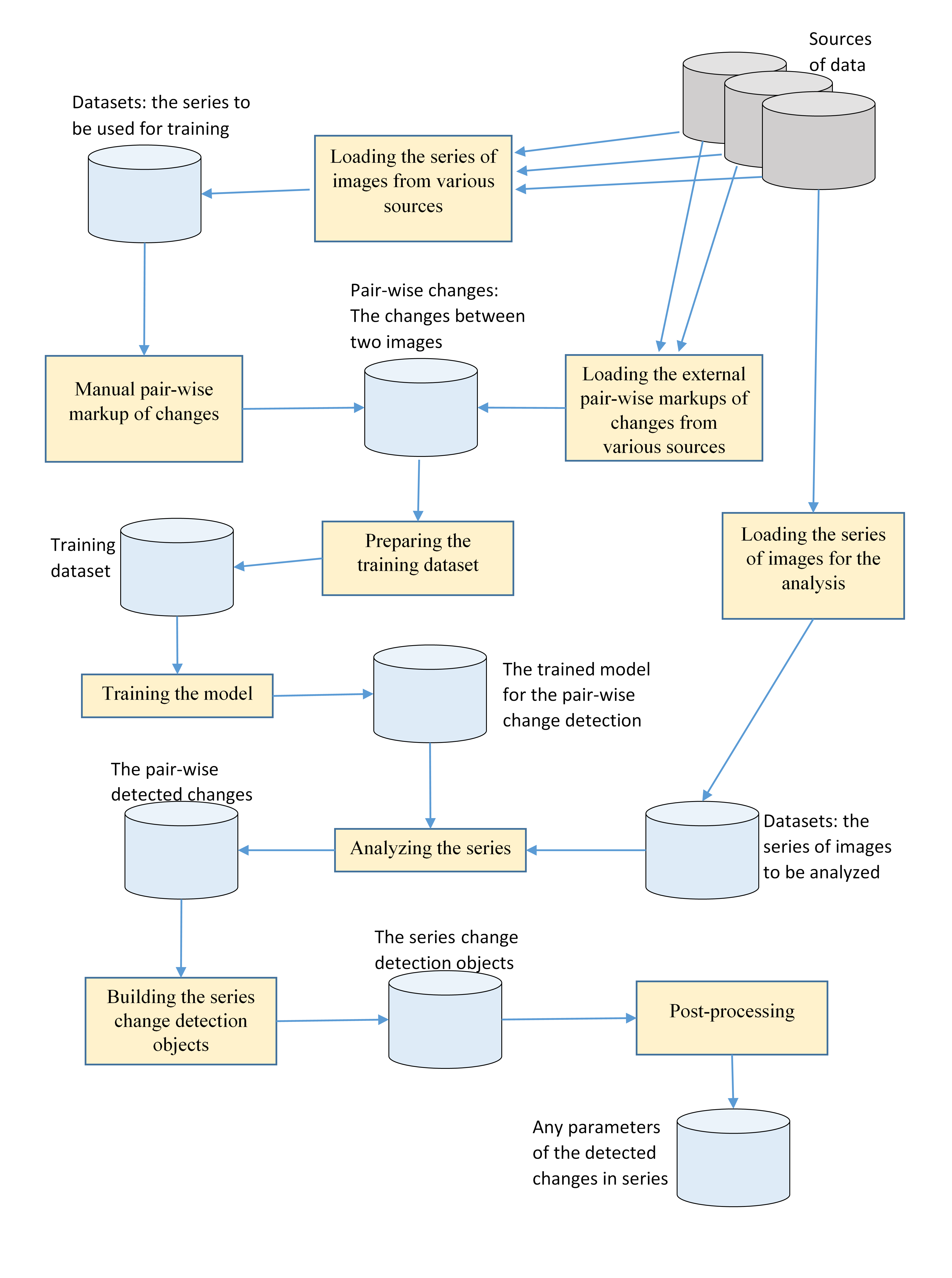
As one can see on the scheme depicted on the figure 1 there are three stages in proposed framework: preparing dataset, training a model and analyzing series of images for pair-wise targeted change detection. Dataset for specific business application should be constructed in accordance with the formal mathematical problem statement described above. It means that one should load series of images concerning the size of targets, the characteristic time period of occurrence of changes, type of images and so on. This data are combined with external mark-ups of changes of objects (targets) under consumption. The model for pair-wise targeted change detection is chosen from the set of neural networks architectures prepared in advance and is trained and validated on the dataset built of the first stage. The process of analyzing new series of images starts from building map of changes for each pair of images inside the series. After that there is a post-processing and verification procedures that resulted in recommendation, forecasts or alerting reports with detected changes, that can be visualized in interactive mode.
3.3 Method of TCD based on deep learning techniques
Our method is fundamentally different from all the methods listed in section 1.3 because it takes into account information about targets of the application under consumption, is based on deep neural network trained and validated on representative dataset, can be automatically adopted to a new territory.
The approach we are developing is based on a specific architecture of the convolutional network which has had a great success in solving the semantic segmentation problems. In the mathematical problem statement, a general formal description of the detected changes is introduced for a pair of images; the description being applied to all datasets analyzed. The neural network architecture makes it possible to use the pre-trained parameters of the network and adapt it to new datasets with an additional training at a very little expense.
The technique can be applied to all pairs of the images in the series; the post-processing is then used to build a more common object that describes the image evolution within the series. The post-processing can be specific for each business application and does not depend on the deep learning technique used at the early stages of analysis.
4 Conclusion
In this paper we have summarized the knowledge about the business applications of change detection, known methods of the image processing and deep learning and the possibilities and limitations of the RS data to propose a generalized framework that can embed the solutions for different problems in the area of the targeted change detection in the remote sensing data. The proposed framework to be implemented in our future research will facilitate the integration of the current and future data sources and the advanced algorithms of the data processing.
References
- (1) PlanetScope Flock, http://space.skyrocket.de/doc_sdat/flock-1.htm
- (2) Gamaya, https://gamaya.com/
- (3) DigitalGlobe Services, https://www.digitalglobe.com/industries/agriculture
- (4) Exact Farming, www.exactfarming.com
- (5) Sovzond, https://sovzond.ru/
- (6) Unmanned Systems, http://unmanned.ru/en/
- (7) Orbital Eye - PIMSyS, https://orbitaleye.nl
- (8) Zala Aero Group, http://zala.aero/
- (9) I-Cubed, http://www.i3.com/
- (10) Satellite Imaging Corporation, www.satimagingcorp.com
- (11) European Space Agency, http://www.esa.int/ESA
- (12) OOO Rilos, https://geomatrix-retail.com/
- (13) Geomarketing & Location Intelligence, https://www.gim.be/en/products-services/gim-expertise/geomarketing-location-intelligence
- (14) Bourdis, N., Marraud, D., & Sahbi, H. (2011, July). Constrained optical flow for aerial image change detection. In Geoscience and Remote Sensing Symposium (IGARSS), 2011 IEEE International (pp. 4176-4179). IEEE.
- (15) SAR Change Detection Dataset, http://fenggao.sinaapp.com/san_dataset.html
- (16) Google Earth Engine, https://earthengine.google.com/datasets/
- (17) CDnet, http://www.changedetection.net/
- (18) Dong, J., Zhuang, D., Huang, Y., & Fu, J. (2009). Advances in multi-sensor data fusion: Algorithms and applications. Sensors, 9(10), 7771-7784.
- (19) Zhang, J. (2010). Multi-source remote sensing data fusion: status and trends. International Journal of Image and Data Fusion, 1(1), 5-24.
- (20) Santilli, G., Vendittozzi, C., Cappelletti, C., Battistini, S., & Gessini, P. (2018). CubeSat constellations for disaster management in remote areas. Acta Astronautica.
- (21) https://www.intelligence-airbusds.com/files/pmedia/public/r2928_9_int_012_spot6-7_en_low-2.pdf
- (22) http://worldview3.digitalglobe.com/
-
(23)
https://www.planet.com/products/satellite-
imagery/files/Planet_Combined_Imagery_Product_Specs_December2017.pdf - (24) https://qz.com/1126301/the-company-photographing-every-spot-of-land-on-earth-every-single-day/
- (25) Fernàndez-Prieto, D., & Marconcini, M. (2011). A novel partially supervised approach to targeted change detection. IEEE Transactions on Geoscience and Remote Sensing, 49(12), 5016-5038.
- (26) Ye, S., Chen, D., & Yu, J. (2016). A targeted change-detection procedure by combining change vector analysis and post-classification approach. ISPRS Journal of Photogrammetry and Remote Sensing, 114, 115-124.
- (27) Toth, C., & Jóźków, G. (2016). Remote sensing platforms and sensors: A survey. ISPRS Journal of Photogrammetry and Remote Sensing, 115, 22-36.
- (28) ENVI software, https://www.harris.com/solution/envi
- (29) Roper, W., & Dutta, S. (2005). Oil spill and pipeline condition assessment using remote sensing and data visualization management systems. In: 2005 ESRI User Conference Proceedings, San Diego, California, pp. 1-25.
- (30) Wang, B., Choi, J., Choi, S., Lee, S., Wu, P., & Gao, Y. (2017). Image Fusion-Based Land Cover Change Detection Using Multi-Temporal High-Resolution Satellite Images. Remote Sensing, 9(8), 804.
- (31) Huang, S., Ramirez, C., Kennedy, K., Mallory, J., Wang, J., & Chu, C. (2017). Updating land cover automatically based on change detection using satellite images: case study of national forests in Southern California. GIScience & Remote Sensing, 54(4), 495-514.
- (32) Mcdermid, G. J., Pape, A., Chubey, M. S., & Franklin, S. E. (2003, October). Object-oriented analysis for change detection. In Proceedings of the 25th Canadian symposium on remote sensing, Montréal, Canada (pp. 14-17).
- (33) Almutairi, A., & Warner, T. A. (2010). Change detection accuracy and image properties: a study using simulated data. Remote Sensing, 2(6), 1508-1529.
- (34) Cai S., & Liu, D. (2015). Detecting Change Dates from Dense Satellite Time Series Using a Sub-Annual Change Detection Algorithm. Remote Sensing, 7, 8705-8727. doi:10.3390/rs70708705.
- (35) Vakalopoulou, M., Karantzalos, K., Komodakis, N., & Paragios, N. (2015). Simultaneous registration and change detection in multitemporal, very high resolution remote sensing data. In Proceedings of the IEEE Conference on Computer Vision and Pattern Recognition Workshops (pp. 61-69).
- (36) Yu, H., Yang, W., Hua, G., Ru, H., & Huang, P. (2017). Change Detection Using High Resolution Remote Sensing Images Based on Active Learning and Markov Random Fields. Remote Sensing, 9(12), 1233.
- (37) Gu, W., Lv, Z., & Hao, M. (2017). Change detection method for remote sensing images based on an improved Markov random field. Multimedia Tools and Applications, 76(17), 17719-17734.
- (38) Jianya, G., Haigang, S., Guorui, M., & Qiming, Z. (2008). A review of multi-temporal remote sensing data change detection algorithms. The International Archives of the Photogrammetry, Remote Sensing and Spatial Information Sciences, 37(B7), 757-762.
- (39) Huang, L., Fang, Y., Zuo, X., & Yu, X. (2015). Automatic change detection method of multitemporal remote sensing images based on 2D-Otsu algorithm improved by firefly algorithm. Journal of Sensors, 2015.
- (40) Vittek, M., Brink, A., Donnay, F., Simonetti, D., & Desclée, B. Land cover change monitoring using Landsat MSS/TM satellite image data over west africa between 1975 and 1990. Remote Sensing 2014; 6 (1): 658-676.
- (41) Jabari, S., & Zhang, Y. (2016, April). Building change detection using multi-sensor and multi-view-angle imagery. In IOP Conference Series: Earth and Environmental Science (Vol. 34, No. 1, p. 12-18). IOP Publishing.
- (42) El Amin, A. M., Liu, Q., & Wang, Y. (2016, July). Convolutional neural network features based change detection in satellite images. In First International Workshop on Pattern Recognition (Vol. 10011, p. 100110W). International Society for Optics and Photonics.
- (43) Chu, Y., Cao, G., & Hayat, H. (2016). Change Detection of Remote Sensing Image Based on Deep Neural Networks.
- (44) Lyu, H., Lu, H., & Mou, L. (2016). Learning a transferable change rule from a recurrent neural network for land cover change detection. Remote Sensing, 8(6), 506.
- (45) Sakurada, K., Okatani, T., & Deguchi, K. (2013, June). Detecting changes in 3D structure of a scene from multi-view images captured by a vehicle-mounted camera. In Computer Vision and Pattern Recognition (CVPR), 2013 IEEE Conference on (pp. 137-144). IEEE.