Measuring Territorial Control in Civil Wars
Using Hidden Markov
Models:
A Data Informatics-Based Approach
Abstract
Territorial control is a key aspect shaping the dynamics of civil war. Despite its importance, we lack data on territorial control that are fine-grained enough to account for subnational spatio-temporal variation and that cover a large set of conflicts. To resolve this issue, we propose a theoretical model of the relationship between territorial control and tactical choice in civil war and outline how Hidden Markov Models (HMMs) are suitable to capture theoretical intuitions and estimate levels of territorial control. We discuss challenges of using HMMs in this application and mitigation strategies for future work.
1 Introduction
Territorial control is a key aspect shaping the dynamics of civil war. Information about who commands what degree of control in which area is crucial for military and civilian actors on the ground, as well as analysts of the conflict. Territorial control allows armed actors to extract resources, increase their mobilization base, and pursue civilian collaboration. For development practitioners and scholars of civil war, territorial control is a central aspect in analyzing patterns of civilian victimization and the provision of public goods. Existing research suggests that when actors do not command high levels of control, atrocities against noncombatants become more likely [1, 13, 16, 8] and the civilian population is at a higher risk to suffer from an under-provision of public goods [15].
Despite its centrality for both practitioners and scholars working within the realm of the security-development nexus, we lack data on territorial control that are fine-grained enough to account for subnational spatio-temporal variation and cover a large set of conflicts . Existing efforts of measuring territorial control in civil wars are either too crude to account for subnational spatio-temporal variation [16, 11, 6, 4, 5], reduce to simple center versus periphery dynamics [13], are limited to a single conflict setting [9, 8], or are resource intensive to create [1, 17]. We fill this void by proposing a novel measurement strategy that utilizes publicly available event data and reasons with it in a machine learning framework to estimate territorial control in asymmetric civil wars.
Our approach leverages the insight that the level of rebel territorial control influences their tactical choice. Broadly speaking, rebels choose between fighting the government conventionally via direct military confrontation, or coercively via terrorism against non-military state forces and the civilian population. Indeed, as Figure 1 shows for India and Nigeria in 2013, we observe surprisingly little overlap between conventional war fighting and terrorist attacks.
Drawing from insights of the existing literature, we expect that the lower the level of territorial control by rebels, the higher their propensity to use terrorism will be, and vice versa [6, 2].111A strong power asymmetry between the rebels and the government is a scope condition for the applicability of our model because only relatively weak rebels are likely to resort to terrorism. Based on existing estimates of rebel strength [4], and considering only cases in which the rebels were weaker or much weaker than the government, the method could be applied to approximately 50 cases between 1997 and 2014. We overlay our area of observation with a grid structure and conceptualize the number of terrorism and conventional war acts within each grid cell as an observable indicator of an underlying unobserved variable territorial control.
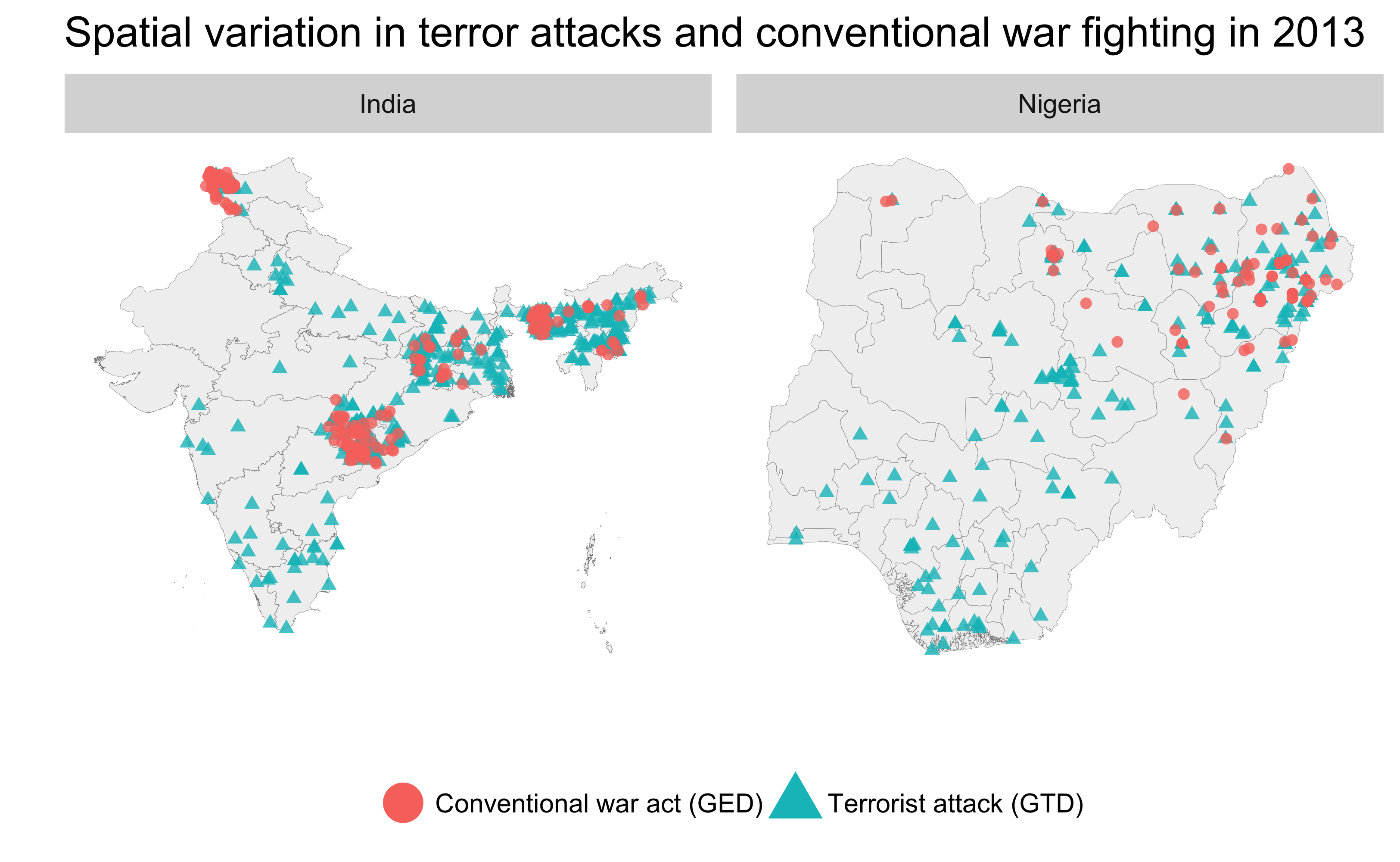
* This figure consists of data from GED and GTD. Data from GED and GTD are owned by their respective owners and are distributed under other licenses. Shape files describing country borders come from the Global Administrative Areas version 2.8 (http://www.gadm.org).
Based on this theoretical model of the relationship between territorial control and tactical choice in civil war, in this extended abstract, we outline how a Hidden Markov Model (HMM) is suitable to capture theoretical intuitions and estimate levels of territorial control within a machine learning framework. We also discuss some challenges and mitigation strategies for future work.
2 Model and data
We divide the region of interest into small cells and employ an HMM [12] for each of these cells. In an HMM, the true state (also referred to as the hidden state) of the system—here, the level of territorial control—is hidden from observation and its evolution follows a Markov process. This explicitly models the temporal dependencies of territorial control. Each hidden state induces a probability distribution over possible observable outputs. In the Markov process, the probability of transitioning from one hidden state to another is called a transition probability. The probability that a hidden state produces a specific observable output is called an emission probability.
In our HMM, each hidden state represents a level of government/rebel territorial control of a specific geographical region. Each hidden state at year produces an observable output . Here, we use the numbers of terrorist attacks () and conventional war acts () as observable outputs. We aggregate the annual number of terrorist attacks from the GTD [10] and conventional war acts from the GED databases [3] to 0.5-by-0.5 decimal degree cells using the PRIO-GRID [18].222We consider only events that can at minimum be linked to a second order administrative region. For the GED, we consider only state-based events—excluding events that are coded as either violence against civilians or non-state conflicts. For the GTD, we exclude terrorist attacks perpetrated against military targets.
To take the spatial correlation between cells into account, we employ a Hidden Markov Random Field (HMRF). We consider the class of HMRFs that consist of a collection of HMMs and assume correlation between the hidden states of these HMMs. In the context of territorial control in civil wars, we impose a correlation, such as the Potts model, only between HMMs of neighboring cells to model the spatial correlation thereof.
3 Discussion of challenges and mitigation strategies
HMMs are well suited to model territorial control for two reasons. First, we know that certain phenomena, such as tactical choice by rebels, are likely to be highly correlated with, and their patterns therefore informative about, levels of territorial control on the ground [6, 2, 5]. HMMs allow us to model this intuition. If territorial control influences tactical choice, we can perceive observed patterns of war fighting as an emission of the underlying (unobserved) level of territorial control. Second, since HMMs explicitly model the sequencing of hidden states, they are a suitable tool to model the evolution of territorial control over time.
However, the measurement of territorial control via HMMs also entails a number of challenges. First, HMMs are typically used to model a single sequence of states. However, in our application domain, the evolutions of territorial control between neighboring cells are unlikely to be independent. Diffusion processes for both the location and escalation of violence are well documented [14]. Although conceptually it is easy to incorporate spatial dependency into our model, it introduces disproportionate computational difficulties. An HMM can be solved by using fast and simple algorithms (such as the Baum-Welch algorithm [12]), but an HMRF usually requires much more complicated approaches. For example, a method utilizing Markov Chain Monte Carlo is known to solve an HMRF that may suit the characteristics in our application [7].
Second, even in the case of very active insurgencies, terrorist attacks or conventional war as captured by widely used event datasets are relatively rare events and therefore not normally distributed. This forces us to assume the number of events to be drawn from a Poisson distribution, rather than a Gaussian distribution, which is usually more difficult to analyze. Making things worse, there is a trade-off between the number of events per unit of observation and the cell size of the imposed grid structure. The more fine-grained the grid structure (and therefore the higher the resolution of the resulting estimates of territorial control), the lower the number of events that are observed per grid cell will be. Therefore, we need to estimate the optimal size of grid cells. We implement this by varying the cell size and shape (squares versus hexagons) using simulated data.
Third, standard HMMs do not allow for the inclusion of covariates. However, a number of available data are informative about an area’s underlying propensity to change between different states of territorial control, such as land cover or terrain. One avenue to leverage covariates might be to model the transition and emission probabilities to be perturbed by functions of these factors. For example, dense forest cover might make it harder for the government to re-capture rebel strongholds—thus the probability of transiting between different states could be subtracted by a monotonically increasing function of forestation.
Furthermore, standard HMMs assume the hidden states to be discrete. However, while we can conceptualize territorial control to fall into discrete categories, in reality it is likely to be a continuous measure on a spectrum from full rebel to full government control. It is well known that modeling HMMs with continuous hidden states is in general much harder than that with discrete hidden states. One direction to resolve this issue may be to apply a Kalman or particle filter.
Finally, the motivation of this paper lies in the scarcity of existing data on territorial control that is fine-grained enough to account for temporal and spatial variation on the subnational level. While this increases the marginal value of new estimates, it also means that appropriate training and testing data for our algorithm is hard to obtain. To resolve this issue, we consider simulated data leveraging insights from well-established theories of territorial control [6, 8].
4 Conclusion
In this extended abstract, we proposed that the HMM and its extensions are suitable for estimating general patterns of territorial control in asymmetric civil wars. Future work tackles the challenge of spatial correlation between HMMs of neighboring cells by using the HMRF and developing better algorithms to account for continuous hidden states and any other spatial dependencies on domain-specific factors, such as land cover and terrain.
References
- Aronson et al. [2017] J. Aronson, D. Ciland, P. K. Huth, and J. I. Walsh. An enhanced dataset of territorial control by conflict actors. Paper presented at the 2017 Meeting of the American Political Science Association, September 2017.
- Carter [2015] D. B. Carter. When terrorism is evidence of state success: securing the state against territorial groups. Oxford Economic Papers, 67(1):116, 2015. doi: 10.1093/oep/gpu041.
- Croicu and Sundberg [2017] M. Croicu and R. Sundberg. UCDP GED codebook version 17.1. Technical report, Department of Peace and Conflict Research, Uppsala University, 2017.
- Cunningham et al. [2013] D. E. Cunningham, K. S. Gleditsch, and I. Salehyan. Non-state actors in civil wars: A new dataset. Conflict Management and Peace Science, 30(5):516–531, 2013. doi: 10.1177/0738894213499673.
- de la Calle and Sánchez-Cuenca [2012] L. de la Calle and I. Sánchez-Cuenca. Rebels without a Territory: An Analysis of Nonterritorial Conflicts in the World, 1970–1997. Journal of Conflict Resolution, 56(4):580–603, 2012.
- de la Calle and Sánchez-Cuenca [2015] L. de la Calle and I. Sánchez-Cuenca. How armed groups fight: Territorial control and violent tactics. Studies in Conflict & Terrorism, 38(10):795–813, 2015. doi: 10.1080/1057610X.2015.1059103.
- Green and Richardson [2002] P. J. Green and S. Richardson. Hidden Markov models and disease mapping. Journal of the American Statistical Association, 97(460):1055–1070, 2002. doi: 10.1198/016214502388618870.
- Kalyvas [2006] S. N. Kalyvas. The Logic of Violence in Civil War. Cambridge University Press, Cambridge, UK, 2006.
- Kalyvas and Kocher [2009] S. N. Kalyvas and M. A. Kocher. The dynamics of violence in Vietnam: An analysis of the Hamlet Evaluation System (HES). Journal of Peace Research, 46(3):335–355, 2009. doi: 10.1177/0022343309102656.
- National Consortium for the Study of Terrorism and Responses to Terrorism (2016) [START] National Consortium for the Study of Terrorism and Responses to Terrorism (START). Global terrorism database [data file]. http://www.start.umd.edu/gtd, 2016.
- Polo and Gleditsch [2016] S. M. Polo and K. S. Gleditsch. Twisting arms and sending messages. Journal of Peace Research, 53(6):815–829, 2016. doi: 10.1177/0022343316667999.
- Rabiner [1989] L. R. Rabiner. A tutorial on hidden Markov models and selected applications in speech recognition. Proceedings of the IEEE, 77(2):257–286, 1989. doi: 10.1109/5.18626.
- Schutte [2017] S. Schutte. Geographic determinants of indiscriminate violence in civil wars. Conflict Management and Peace Science, 34(4):380–405, 2017. doi: 10.1177/0738894215593690.
- Schutte and Weidmann [2011] S. Schutte and N. B. Weidmann. Diffusion patterns of violence in civil wars. Political Geography, 30(3):143–152, 2011. ISSN 0962-6298. doi: 10.1016/j.polgeo.2011.03.005.
- Stewart [Forthcoming] M. A. Stewart. Civil war as state building: The determinants of insurgent public goods provision. International Organization, Forthcoming.
- Stewart and Liou [2017] M. A. Stewart and Y.-M. Liou. Do good borders make good rebels? Territorial control and civilian casualties. The Journal of Politics, 79(1):284–301, 2017. doi: 10.1086/688699.
- Tao et al. [2016] R. Tao, D. Strandow, M. Findley, J.-C. Thill, and J. Walsh. A hybrid approach to modeling territorial control in violent armed conflicts. Transactions in GIS, 20(3):413–425, 2016. ISSN 1467-9671. doi: 10.1111/tgis.12228.
- Tollefsen et al. [2015] A. F. Tollefsen, K. Baghat, J. Nordkvelle, and H. Buhaug. PRIO-GRID v.2.0 Codebook. Technical report, Peace Research Institute Oslo, 2015.