On a Possible Giant Impact Origin for the
Colorado Plateau
Abstract
It is proposed and substantiated that an extraterrestrial object of the approximate size and mass of Planet Mars, impacting the Earth in grazing incidence along an approximately N-NE to S-SW route with respect to the current orientation of the North America continent, at about 750 million years ago (750 Ma), is likely to be the direct cause of a chain of events which led to the rifting of the Rodinia supercontinent and the severing of the foundation of the Colorado Plateau from its surrounding craton.
It is further argued that the impactor was most likely a rogue exoplanet, which originated from one of the past crossings of our Solar System through the Galactic spiral arms, during the Sun’s orbital motion around the center of the Milky Way Galaxy. New advances in galactic dynamics have shown that the sites of galactic spiral arms are locations of density-wave collisionless shocks. The perturbations from such shocks are known to lead to the formation of massive stars, which evolve quickly and die as supernovae. The blastwaves from supernova explosions, in addition to the spiral-arm collisionless shocks themselves, could perturb the orbits of the streaming disk matter, occasionally producing rogue exoplanets that can reach the inner confines of our Solar System. The similarity of the period of spiral-arm crossings of our Solar System, with the approximate period of major extinction events in the Phanerozoic Eon of the Earth’s history, as well as with the (half) period of the supercontinent cycle, indicates that the global environment of the Milky Way Galaxy may have played a major role in initiating Earth’s tectonic activities.
keywords:
Keywords: giant impact; plate tectonics; Colorado Plateau1 Introduction
Evolving from the continental drift hypothesis of Wegener (1929) et al., plate tectonics is the present working paradigm to explain the geomorphology of our Planet Earth (for historical accounts, see, e.g., Sullivan 1991; as well as the many contributions in Oreskes 2003). The basic scenarios offered by plate tectonics had successfully accounted for the formation of mountain ranges at the converging and diverging boundaries of continental and oceanic plates.
Within the plate tectonic paradigm, mantle convection and mantle plume scenarios were proposed as the main driving mechanisms for the Earth’s tectonic movement. This proposal, however, has trouble to account for the sharp change in alignment of the Emperor-Hawaii island chain (one of several similarly sharply-bent island chains in the Pacific), which was hypothesized to be produced by a stationary hotspot anchored in the mantle, coupled with the steady movement of the overlying Pacific Plate (Wilson 1963). Mantle convection would have difficulty to explain the stationary nature of the hotspot’s anchor on the mantle, a required feature if the Emperor-Hawaii island chain is produced through a fixed hot spot and slowly moving Pacific plate above it. The convection picture furthermore cannot explain the sudden change in direction of the emerging island chain half-way through the Pacific Plate’s motion. This sharp-bending feature was sometimes proposed to be produced by the collision of India with the Himalayan region of Asia in the middle of the Cenozoic era. If this is true, on the other hand, it in fact highlights the possibility that major changes to plate motion can be initiated by kinematic and dynamic events at the crustal surface level, rather than at the underlying mantle level. For mantle convection cell to be as large as the whole Pacific Plate is also difficult to conceive, and one also needs a coupling machanism between the asthenosphere and the lithospherical plates across the Low-Viscosity-Zone to be able to drive the plate motion even if organized large-scale mantle convection does exist (Price 2001).
Furthermore, the striking geomorphology of southern Rocky Mountains in western United States, which is the subject of our current paper, is formed in an intra-cratonic setting (i.e., the Colorado Plateau is surrounded on all sides by mountains within a single ancient craton), and it cannot be naturally explained through the subductions of oceanic plates, which are usually shallow-angled and do not lead to the prevailing high-angle strike-slip faults at the Plateau’s boundary (Twento 1980) which had incised the Colorado Plateau from the surrounding craton. Our sentiments on this issue echoed that of many past workers of the Rocky Mountains area: “Plate-tectonic theorists pondering the Rockies have been more than a little inconvenienced by the great distances that separate the mountains from the nearest plate boundaries, where mountains theoretically are built. The question to which all other questions lead is, What could have hit the continent with force enough to drive the overthrust and cause the foreland mountains to rise?” (McPhee 1998, p. 384); “The Owl Creek Mountains and the Uinta Mountains trend east-west. Why? Why are their axes ninety degrees from what you would expect if the tectonic force came from the west?” (David Love, as quoted in McPhee 1998, pp. 385-386).
An alternative driver for plate motion, that of the giant impacts from Solar-System’s asteroids and comets, had also been explored in the past few decades (Price 2001 and the references therein), which has the potential to explain the sudden change of plate-motion directions, as well as the intra-cratonic orogenic events. One severe limitation of the past impact proposals is the ultimately achievable magnitude of the impacts, if these were produced solely by the objects of the mature Solar System. The giant planets of our Solar System had achieved their stable orbits when the Earth was still in its youth, and the asteroids and comets of the Solar System, while possessing potentially Earth-crossing orbits, are generally small in size and mass, which make it problematic if we were to hypothesize that both the initial partial loss of the crust of the Earth (assuming the terrestrial crust was formed full initially, covering the whole Planet like that on Venus), as well as the subsequent cycles of supercontinent formation and dispersal, were caused mainly by giant impacts.
An examination into the frequency distribution of major extinction events within the Phanerozoic Eon (§4) reveals furthermore an episodic trend of the most important of these extinction events, with the quasi-period of these events (especially the clustering of major events) similar to that of the Galactic Year of 250 million years duration. In section 4 we will also demonstrate that the Galactic Year is similar to the period of crossing of the Solar System across one of the two major spiral arms at the Solar circle, and discuss in more detail how this periodic spiral-arm-crossing may facilitate the periodic production and invasion of rogue exoplanets into the inner confines of our Solar System, contributing both to the supercontinent cycles and to the periodic occurrence of major extinction events in the Phanerozoic Eon. In the current paper we present a first example of the important role giant impacts may have played in shaping the Earth’s tectonic history.
2 Geological Environment of the Colorado Plateau
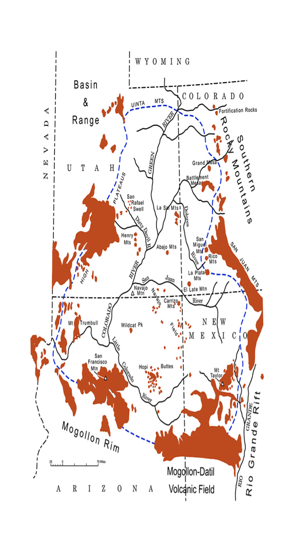
The Colorado Plateau is centered around the Four Corners region (i.e., the intersection of the states of Colorado, Utah, Arizona, and New Mexico) of the southwestern United States. It encompasses an area of roughly 337,000 km2. It is an uplifted high-desert plateau of a shallow bowl shape (i.e., with its rims generally of higher elevation than its interior). The elevation of the Plateau ranges from 1 - 4.7 km, with an average elevation about 1.7 km.
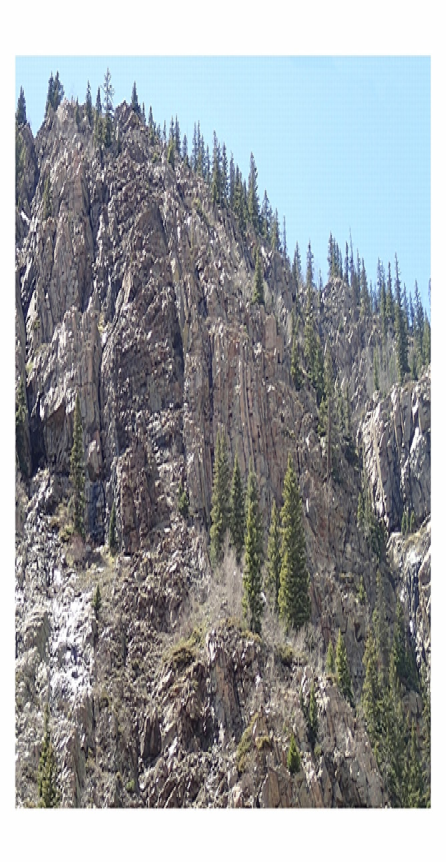
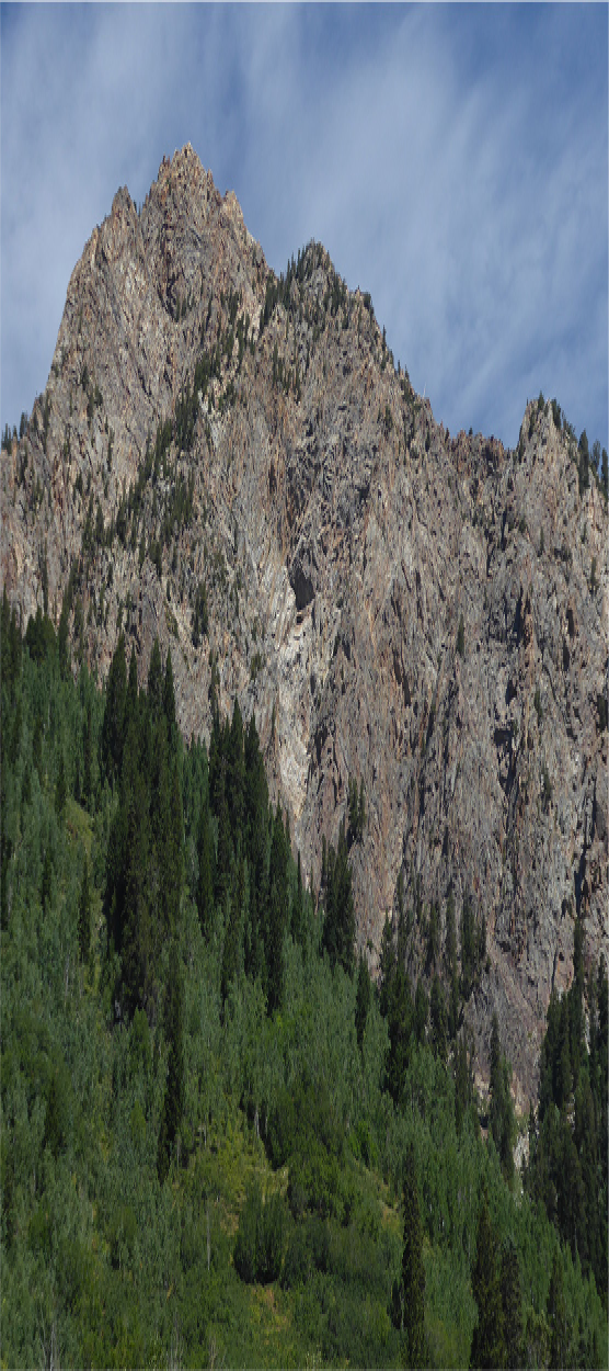
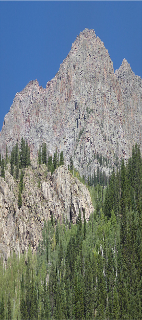
One distinguishing characteristic of the Colorado Plateau is its structural stability (Kelley 1979 and the references therein). It was shown to have been little faulted or folded during the past 600 million years, whereas in its surrounding area there were repeated orogenic and igneous activities during the Phanerozoic Eon (Figure 1). In the west, the Plateau is delineated by the Wasatch Line, a fault line which marks one of the innermost boundaries along which the Rodinia supercontinent, most recently assembled between 1.1 - 1 Ga, split circa 750 Ma (this line coincides roughly with the Interstate-15 freeway from Salt Lake City, Utah, to Las Vegas, Nevada). In one of the proposed Rodinia rifting configurations (SWEAT-Configuration), Australia and East Antarctica broke off from Rodinia’s western side around 750 Ma (Moores 1991), and this episode is followed by sustained periods of miogeocline buildup (Dickinson 1989). Other proposed rifting configurations and hinge lines have varying degrees of differences from SWEAT. The fuzziness of the rifting hingeline in some of the proposed rifting configurations is due in part to the possible subsequent re-assembly of minor broken pieces along the resulting supercontinent Laurentia (ancient North America)’s western edge. Beyond the Wasatch Line to the west is the younger Basin and Range province, which continues slightly beyond the rest of the three sides of the Plateau as well. In the east side, the Plateau boundary is marked by the Southern Rocky Mountains in Colorado, and by the onset of the Rio Grande Rift Valley in New Mexico. Its southern boundary is delineated by the Mogollon Rim in Arizona and the Mogollon-Datil Volcanic Field in New Mexico. Its northern boundary is lined by the Uinta Mountains in Utah, which merges into the northern portion of the Southern Rocky Mountains. Part of the orogenic features of the Plateau’s northern boundary in fact continues further north to the Central Rocky Mountains in Wyoming, Idaho, and Montana. The Grand Canyon of the Colorado River is located on the Plateau’s western side within Arizona. The Black Canyon of the Gunnison River lies in the eastern side of the Plateau within Colorado.
Additional geological features of the Plateau and its environment which motivate our giant-impact hypothesis include:
-
1.
The Colorado Plateau is roughly centered on a set of perpendicular wrench (transform) faults (Baars and Stevenson 1981) of cross-continent sizes. Though the initiation of segments of these faults could be as early as 1.7 Gyr (Baars 2000), the proposed 750 Ma impact event, which we will detail later in this paper, likely had enlarged/reactivated these faults. The Plateau’s boundaries were delineated by high-angle transform faults originating from the Neoproterozoic era, which are likely to be responsible for the initial severing of the entire Plateau crustal block from its surrounding North America craton, but which did not lead to immediate uplift of the Plateau in the Precambrian time due (likely) to the confining pressure from the same surrounding craton. Many of these high-angle faults did not evolve to become thrust faults until the Laramide Orogeny of Late Cretaceous/early Tertiary time (Kelly and Clinton 1960). The uplifting of the Colorado Plateau itself occurred mainly in the Cenozoic, and the cause of which could be the combined effects of Laramide Orogeny, the Basin-and-Range extension dynamics, and the shallow-angle subduction of the Farallon Plate from the west, all of which are capable of re-activating the Proterozoic high-angle faults surrounding the Plateau boundary, and, as we will discussed later in the paper, all of which could themselves be the consequences of other giant impact events.
-
2.
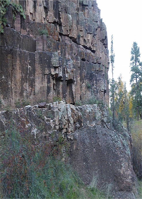
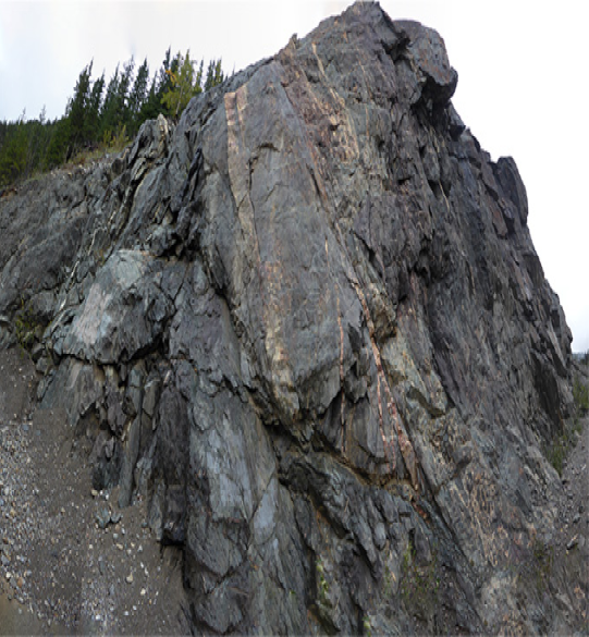
There exists the so-called Great Unconformity in stratigraphy across the Colorado Plateau, reflecting missing sediments of up to 1.2 Gyr, between 1700 Ma and 540 Ma. The most well-known display of this Great Unconformity is in the Inner Gorge of the Grand Canyon of the Colorado River (see, for example, Hamblin 2008), but its presence is wide-spread across the entire Plateau region, and exposures of the Great Unconformity can be found in especially the fissured and faulted areas, both along deep canyons as well as along the Plateau’s boundary regions. Figure 2, Top Frame, shows the Baker’s Bridge Unconformity near Durango, Colorado, which is just beyond the Plateau’s eastern boundary. Figure 2, Bottom Frame, shows another example of the Great Unconformity along Arizona’s state highway 87. The Great Unconformity is also present in other parts of the US (i.e. Wyoming and New York State), as well as in the rest of the world (i.e., Canada, Ireland, and Africa). See further discussions in Van Hise (1909/2017); Ward (2001); Share (2012); Peters and Gaines (2012); and the references therein.
-
3.
Across the Colorado Plateau there exist surface and subsurface detritus material (boulders, cobbles, pebbles and re-lithified crushed rocks) which were derived from either local or nonlocal Precambrian rocks (Barker 1969; Karlstrom 1989; Gonzales et al. 1994; Condon 1995; and the references therein). Figure 2, for example, displays such re-lithified crushed basement rocks just above the Great Unconformity interface. In this case the source material for re-lithification was derived locally, and it clearly shows evidence of having been through partial melting and vitrification. The basement material below the Great Unconformity, on the other hand, also show evidence of melting and flow.
-
4.
In the Grand Canyon region, a segment of the so-called Grand Canyon Supergroup sedimentation sequence (see, e.g., Timmons, Karlstrom, and Sears 2003; Hamblin 2008), with deposition time between 1200 Ma and 750 Ma, were found to be faulted into the basement rock (i.e. the Vishnu Complex) at various locations. Where the Supergroup is present, the time gap representing the Great Unconformity is reduced correspondingly (i.e., the Proterozoic section is terminated at 750 Ma, instead of at 1.7 Ga). It is noteworthy that the top of the outcropped Grand Canyon Supergroup has the deposition age (750 Ma) coinciding with that of the rifting of the Rodinia Supercontinent.
-
5.
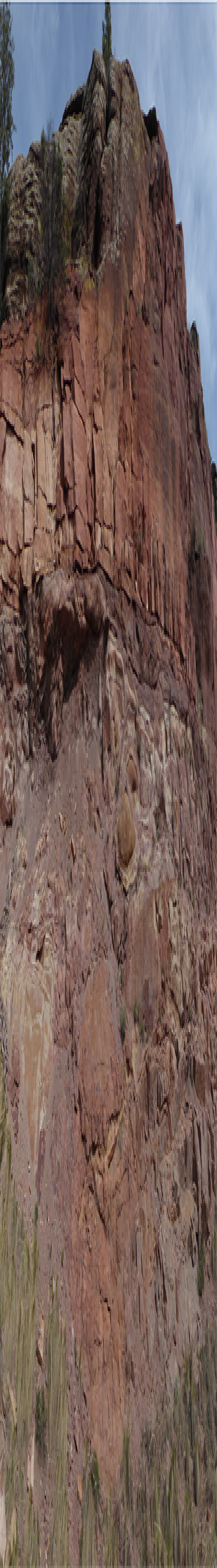
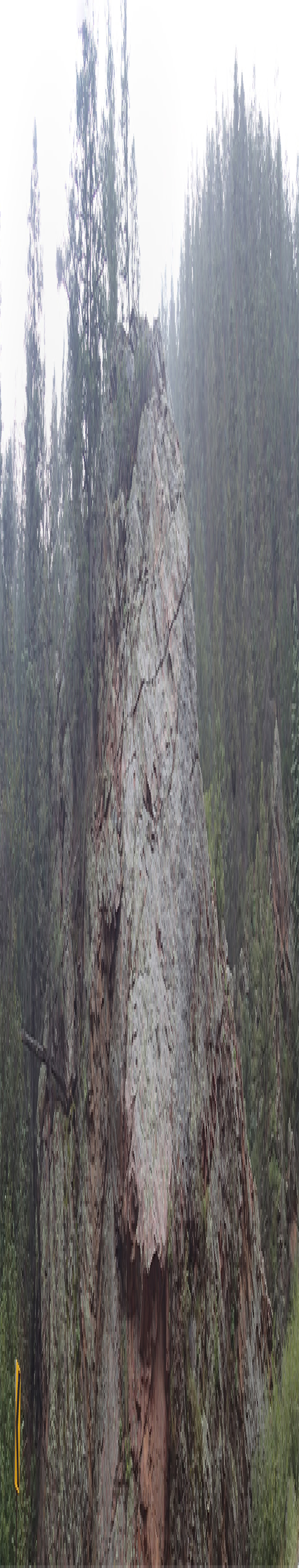
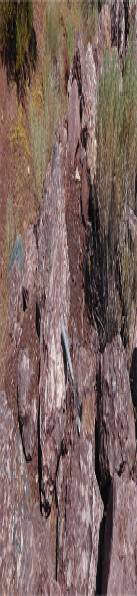
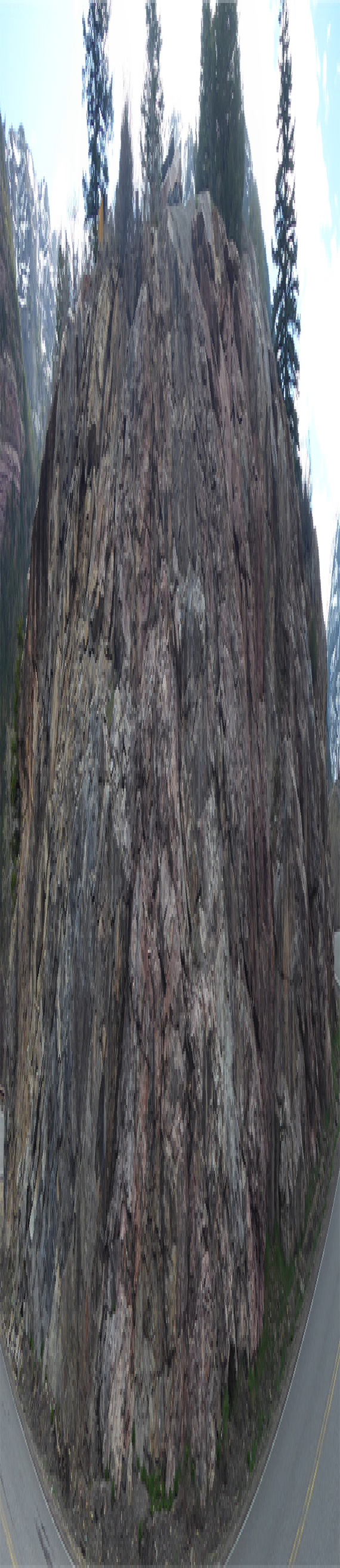
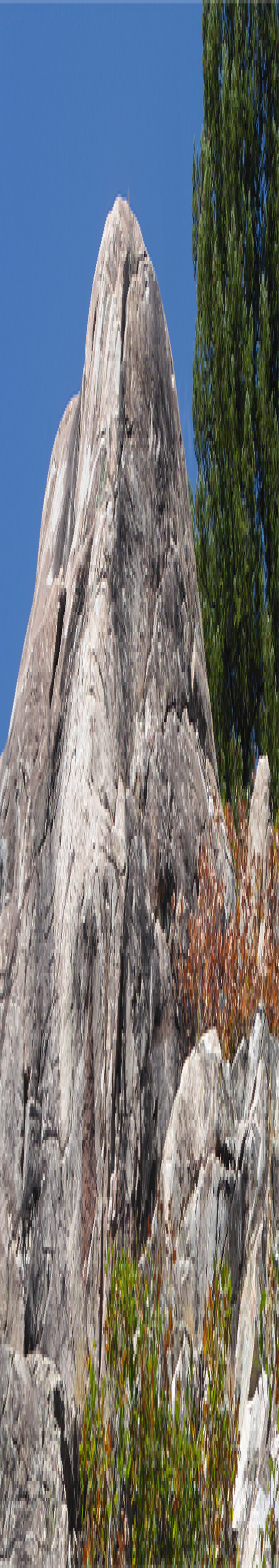
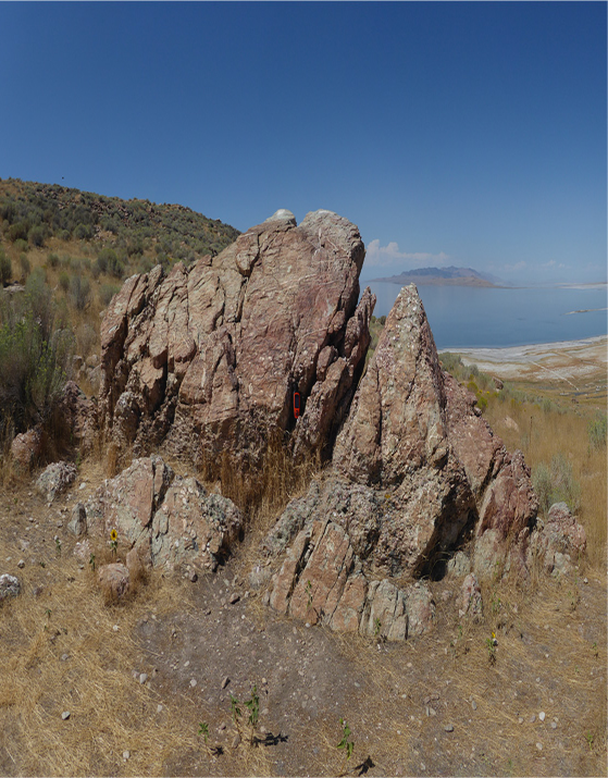
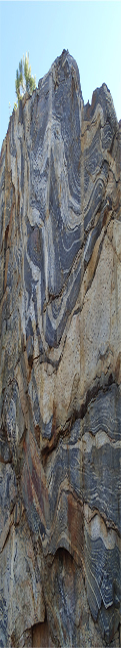
In western Colorado, around the Plateau’s eastern boundary, the Proterozoic Uncompahgre Formation, consisting of alternating layers of quartzite and phyllite, forms the cores of the Grenadier Range and Snowdon Peak of the Needle Mountains, which is part of the western San Juan Mountains. This Formation, which outcrops also at other locations (i.e. along the Animas Canyon near Ouray, Colorado, in various other locales within Needle Mountains, as well as in the Rico area of Colorado), were often found to be severely faulted and folded. Figure 3 shows upturned Uncompahgre Formation along the so-called “million-dollar Highway”, US-550. Figure 4, Top Frame, shows the Uncompahgre Formation in a sandwich pattern (two vertically upturned sections bracketing a central section of normal bedding planes), just south of Silverton, Colorado, along the route of the Durango-Silverton Narrow Gauge Railroad (Gonzales and Heerschap 2012). The formation of this sandwiched sedimentary pattern, which can also be seen in a similar photograph in Blakey and Ranney (2018), clearly requires the action of strong and rapid shear forces, applied in the vertical direction with respect to the normal bedding planes, rather than from the side as is the case for the usual tectonic forces. A related example, in Figure 4, Bottom Frame, shows the late-Devonian Elbert formation unconformably overlying the upturned beds of the Precambrian Uncompahgre Formation at the Box Canyon State Park near Ouray. Note in particular that on the right hand side of this picture of Box Canyon the Uncompahgre Formation itself has two sections oriented nearly 90 degrees from each other in close proximity, similar to the phenomenon shown in Figure 4, Top Frame. Similar images of the Box Canyon Unconformity have previously been shown in Hinds (1936, Plate 4B), in the Geologic Atlas of the Rocky Mountain Region (1972, p. 35), as well as in Baars (1992 p. 31), although these previous images did not highlight the perpendicular orientations of the sediments of the Uncompahgre Formation itself. These patterns of tight, orthogonally-oriented Uncompahgre sediments in juxtaposition, occurring over such a large scale (i.e., the sizes of small mountains) could not possibly have been produced by traditional types of slow and prolonged orogenic events, such as plate subduction or superplume upwelling, and they are most likely the result of an instantaneous, high-shear-rate, and high-intensity giant impact event.
-
6.
In the northern Needle Mountains area, the Uncompahgre Formation forms a synclinorium which is wrapped around the circa 1400 Ma Eolus Granite intrusion (see Zinsser [2006], Figure 2 for the most up-to-date Proterozoic outcrop map of the Needle Mountains area, based on the original map by Barker 1969, supplemented with data from Gibson and Simpson [1988]; Gonzales [1997]; Harris et al. [1987]; and Tewksbury [1981]). In the past, evidence for both allochthonous (Tewksbury 1985a,b, 1986, 1989) and paraautochthonous (Harris et al. 1987; Harris 1990) nature of the Uncompahgre Formation in this area had been reported. The giant impact picture helps to reconcile these two points of view, and regards the synclinorium of highly deformed Uncompahgre Formation as being pushed against and draped around the northern Needle Mountains front by the impactor traveling from N-NE to S-SW. The Uncompahgre Formation in this area thus acquired allochthonous characteristics despite being paraautochthonous when first formed. The giant impact picture also helps to explain the sometimes violent inter-mixing of the Uncompahgre Formation and Eolus Granite, which we will show images later. The pre-existing Eolus Granite intrusion which forms the core of the Needle Mountains is likely also the reason that the Colorado Plateau’s eastern boundary has an inward dent/kink in the western San Juan Mountain area, because the more resistant granite (compared to the cover sequence rocks) likely prevented the chiseling of the otherwise rounded boundary of the impact crater through the granite block, thus the severed Plateau block went around the Needle Mountains’ western boundary.
-
7.
The maps on p. 38-39 of the Geological Atlas of the Rocky Mountain Region (1972, or else see Kelley 1979, Figure 1) show that the major and minor fold axes and faults across the Plateau have a roughly NW-SE orientation, perpendicular to the proposed impact trajectory. Such folds and faults were found to also extend to the north beyond the Uinta Mountains region, which is usually considered the northern boundary of the Plateau – though some geologists, such as Dutton 1882, p. 54, considered the Plateau to extend further north into the Teton Range and northern Rockies, and the paleo-geologic maps of the region confirm such associations (Blakey and Ranney 2008, 2018). The evidence that the possible touch-down spot of the impactor (or area affected by the initial shock wave of the impactor) resides further north in the Rockies includes also the abundance of pebbles, cobbles, and boulders of younger Precambrian age, in the Jackson Hole and Teton Mountains area. These detritus do not seem to have a corresponding local source (Love et al. 2003, p.59), and they could be the result of jetting in the rear of the impactor’s trajectory. Similar pebbles, cobbles and boulders were also found abundantly on the Plateau itself (Condon 1995; Gonzales et al. 1994), composed of parent rocks of Precambrian ages. The cover sequence rocks in the northern Needle Mountains (part of the western San Juan Mountains) show 50% shortening via south-vergent folding and south-directed shearing (Zinsser 2006 and the references therein). The rocks in Taos Range also show pervasive southward shearing fabrics which postdate the rarer northward shearing fabrics (Grambling et al. 1989, p. 107).
-
8.
The Proterozoic cover sequences outcropped along the Plateau’s boundary in all four adjacent states of Arizona, New Mexico, Colorado, and Utah, as well as in the Northern Rocky Mountains (i.e., the Belt Series of Idaho, Montana, and Wyoming – see, e.g., McKee 1972 and the references therein) show similar styles of brecciation and metamorphism. In Utah (Figure 5), the deformation occurs mostly in the Uinta Mountain Group and its western extension, the Big Cottonwood Formation (Hansen 2005, p. 73, 76; Bennis-Smith et al. 2008, Dehler et al. 2010). In the western San Juan Mountains of Colorado (Figure 6), the deformation is most pronounced in the Uncompahgre Formation (Baars 2000, pp. 115-121). In Arizona (Figure 7), deformation is observed in both the Paleoproterozoic Mazatzal and in the late-Mesoproterozoic Apache Groups, and, in milder form (benefited apparently from fault protection), in the Grand Canyon Supergroup which has a Neoproterozoic upper layer. In New Mexico (Figure 8), the deformation occurs in various cover sequence groups in southern Sangre de Cristo Mountains (i.e., the Taos Range, Reed 1984; the Pecuris Range, Montgomery 1956; the Santa Fe Range, Bauer and Raiser 1995; Erslev et al. 2004, etc.). Note that the east side of the Plateau boundary, especially the northeast side (i.e., the Colorado Front Range), appear to have suffered a greater degree of damage as a result of the proposed impact event, which accounts for the higher degree of uplift, erosion, and metamorphism observed there, compared to the west and south side. This could also explain the older ages of the outcropped Precambrian rocks in the north-east region, as a result of the higher degree of uplift and erosion of the Precambrian sediments. Parts of the top-most layers of the cover sequence could also have left the Earth during the impact-induced vaporization. We also need to remember that the ages of formation of the top-most exposed Precambrian cover sequence is not the same as the time of the last major metamorphic event on these rocks. The latter can be much more recent due to the rapid removal of the younger layers of sediments during the impact event.
-
9.
Exposed Proterozoic rocks of the Plateau and surrounding areas also show evidence of dynamical metamorphism likely produced by giant impact in the forms of: (1) Shatter cones of varying sizes, some in clusters spanning miles, with “horsetailing” striations on rock surfaces (Figures 8, 9). These macroscopic features have traditionally been attributed to the shock metamorphism effect from meteorite impact (French 2003); (2) Severe compression and flattening of pebbles embedded in conglomerates (Figure 10, Top Left Frame); (3) Fusing of impact-shattered rocks from a variety of sources in a matrix which itself containing melts, to form suevites (Figures 10, Top Right, Bottom Left, and Bottom Right Frames). See French (2003) for discussion of the impact origin of suevites; (4) Partial melting of large sections of rock bodies to change their nature from quartzite and granite to inhomogeneous igneous rocks formed under nonequilibrium conditions (Figures 11, 12). Cox (2002) discussed psot-deposition alteration of Mazatzal group quartzite in Arizona. Fackelman et al. (2008) found impact shatter cones and microscopic shock alteration to Paleoproterozoic rocks northeast of Santa Fe, New Mexico, within an extended section of the Sangre de Cristo Mountains. Our Figures 8 and 9 confirm such discoveries. The giant impact scenario helps to solve the mystery of Santa Fe impact structure which was previously found to be lacking an obvious impact crater despite the discovery of an abundance of shatter cones in the area (i.e., the whole Colorado Plateau itself is now the proposed impact crater).
-
10.
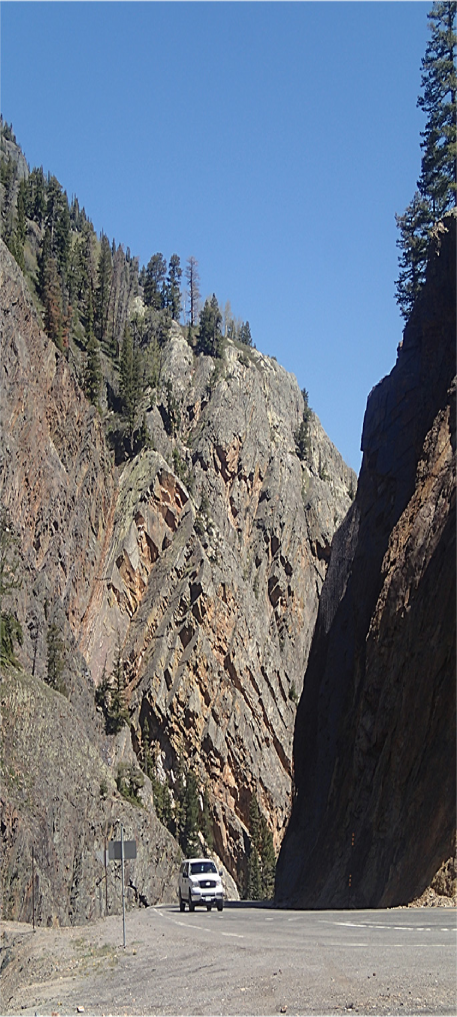
In the Black Canyon of the Gunnison National Park in Colorado, the Canyon walls which are made of Precambrian metamorphic rocks are injected with coherent pegmatite sills and dikes hundred of meters in length (Figure 13). The age of the injection is likely to be Neoproterozoic, based on cross-cutting relationships: the pegmatite dikes are observed to intrude the Mesoproterozoic Vernal Mesa Quartz Monzonite (dated to be 1.22 Ga in age) in Cedar Point and Chasm view area (Hansen 1965). The lengths and coherence of these sills and dikes show that they are likely caused by a single episode of strong and sudden brittle deformation event. As we know, the 1.1 Ga Grenville Orogeny had not significantly affected the Black Canyon of the Gunnison area (and even in areas that the Grenville had affected, the deformation is mostly in the form of ductile deformation. See later Figure 23, Right Frame), and the only other significant tectonic event between the Mesoproterozoic and the onset of the Cambrian is the 750 Ma breakup of the Rodinia Supercontinent.
-
11.
Love et al. (2003, pp. 38-39) mentioned that on Mount Moran (altitude 3,842 m), which is part of the northern Teton Range in Wyoming, the 50 meter-thick black dikes near the summit of the peak, which cut across older Precambrian rocks, are similar to the dikes in Tobacco Root and Beartooth Mountains in Montana, which had been dated by S.S. Harlan at the U.S. Geological Survey to be about 765 Million years old. Similar dikes of estimated Neoproterozoic age can also be found cutting through the Grand Canyon Supergroup (Blakey and Ranney 2008, p. 8); and in the Canadian Rockies (Figure 20) and even in the eastern United States where the eastern side of Rodinia rift occurred following the 750 Ma event. We will address these further later in the text.
-
12.
The uplifting of the Colorado Plateau during the Cenozoic era appears to be in a coherent fashion, in contrast to the haphazard tectonic activities in its surrounding area. This indicates that the basement block of the Plateau was severed from the surrounding craton of the continent, and the Basin-and-Range extensional dynamics of the Cenozoic era apparently helped to relieve some of the confining pressure from the Plateau’s boundary, giving rise to both the Cenozoic igneous activities in the Plateau’s rim, as well as the rise of the modern version of the Rocky Mountains, at the site of the eroded ancestral Rocky Mountains which had first emerged in the Paleozoic era. The well-known thickened root underneath the Plateau (Keller, Braile, and Morgan 1979) could be partly a result of impact-induced granite pluton formation, partly due to the need for isostatic equilibrium in response to the uplift of the Plateau after being freed along its boundary during the extension phase in the Cenozoic era (i.e., the raised height of the Colorado Plateau coupled with its thickened root indicate that the Colorado Plateau is in independent isostatic equilibrium floating above the mantle, supporting the notion that the Plateau is severed from its surrounding craton).
-
13.
Sedimentary record shows that the entire North America continent, including the Colorado Plateau region, was in a very flat configuration at around 600 Ma (Blakey and Ranney 2008, 2018). It is mostly above this flat terrain that the Paleozoic sedimentation was laid. The flat terrain and the wide-spread existence of the Great Unconformity between the Proterozoic and Cambrian indicate that the Great Unconformity is not likely an erosional feature, because there is scant evidence of the erosional remnants of such wide-spread scale. Apart from the detritus of the impact (for example., the conglomerates composed of brecciated Precambrian rocks left over in the Plateau region, and the re-lithified crushed Precambrian rocks), the most natural explanation of the lack of erosional remnants to account for the world-wide presence of the Great Unconformity separating the Proterozoic from the Cambrian, is that the missing layers of sediments have vaporized and left the confines of the Earth.
These characteristics of the Colorado Plateau and its surrounding area, added to the correlation of the timing of the formation of the Great Unconformity with the timing of the rifting of the Rodinia supercontinent at the western margin of the Plateau, as well as the timing of the subsequent rifting at the eastern side of the Rodinia Supercontinent to form the Iapetus ocean, point to the likelihood of a giant impact event occurring around the 750 Ma centered on the Four Corners area of the western United States.
3 Characteristics of the Proposed Giant Impact Event
In this section we proceed to constrain the characteristics of the proposed giant impact event using the known properties of the Colorado Plateau and its environment.
3.1 Size of the Impactor
We take the size of the Colorado Plateau itself as the approximate size of the impact crater. The Colorado Plateau has an area of approximately 337,000 square kilometers, thus a diameter of about (if we add to this the area around the western San Juan Mountains, as done in Kelly 1979, it will increase the total area of the Plateau by about 11%. So the gross estimate would remain valid in either case). Dence et al. (1977) found that for terrestrial impact craters, progressively larger craters tend to have progressively shallower profiles. They quoted result for the 3.6 km Steinheim Basin and Flynn Creek crater (Roddy 1977a,b; Reiff 1977), which has depth-to-diameter ratio of approximately 1 to 24. In our following calculation, we take the impact crater depth to be 1/40 of its diameter, i.e., = 16 km. This depth is reasonable considering that the estimated original depth for the Grand Canyon Supergroup is up to 4 km thick, and the Supergroup itself, since it consists of faulted blocks, does not contain the original bottom contact to the basement rock, which is 1.7 Gyr old (the oldest rocks in the Grand Canyon Supergroup is about 1.2 Gyr old). The exposed Uinta Mountain Group in the eastern Uinta Mountains is up tp 7 km thick at the Colorado-Utah border (Dehler et al. 2010), which also does not reveal its root connecting to the basement rock. Furthermore, we need to consider also the possibility that the entire Plateau Lithospheric block may have sunk slightly into the Asthenosphere at the time of the impact, since it is obviously severed from the surrounding craton, judging from its structural integrity and isostasy behavior (Keller et al. 1979). So our choice of 16 km for the crater size appears to be reasonable, as will be borne out from the overall energetic considerations presented later in this paper.
From a simple geometric consideration (Figure 14), the impactor’s radius is obtained as (taking the radius of the impact crater km)
| (1) |
Therefore the hypothesized impactor is only slightly smaller than Mars’ size ( = 3386 ). From the energy and momentum balance considerations we will present next, the estimated impactor mass also turns out to be comparable to Mars’ mass. Therefore, a Mars-sized impactor allows a self-consistent impact scenario to be obtained, which fits also other known facts related to the hypothesized impact event.
3.2 Energetics of the Impact Event
According to Goldsmith (2001) and the references therein, at low to intermediate range of impact velocities, when the fusion and vaporization of the bodies involved can be neglected, the resisting force to the impactor can be expressed by the following empirical formula:
| (2) |
where the three terms on the right hand side are contributions due to the acceleration of the target material adjacent to the impactor, the effect of the frictional forces, and the cohesive strength of the target, respectively, and represents the vertical component of the impactor’s velocity relative to the target, just before the encounter occurs, and is the mass of the impactor. In this expression the acceleration of the target (i.e., the Earth as a whole in our example) is ignored, since Goldsmith (2001) did not study the kind of giant impact events planetary collisions represent.
For higher impact intensities (as is more relevant to the Colorado Plateau impact event), on the other hand, it is often postulated that the crater volume is proportional to the kinetic energy of the impactor (Melosh 1996).
Dence et al. (1977) found that for large impactors the diameter of the excavated crater and the energy of the impact follow roughly the relation
| (3) |
Take = 640 km, we obtain joules. Our impactor is likely to have collided with the Earth in an grazing-incidence angle (more on that later), judging from the slightly elongated shape of the Colorado Plateau. Taking the impactor’s vertical velocity (relative to the surface of the Colorado Plateau) before the encounter to be km/sec, and taking the impactor mass to be 10% of the mass of the Earth, or , which is just slightly smaller than that of Mars, the potentially-available impact energy would be (assuming about 91% of the vertical-motion kinetic energy of the impactor is dissipated during the impact event, as our later calculation using equation (8) would suggest):
| (4) |
which is larger by more than 3 orders of magnitude than the estimation using the Dence et al. (1977) equation based on the impact crater size, which we had quoted above.
However, we need to keep in mind that the excavation of the Colorado Plateau is not the only usage of the impactor’s available kinetic energy, since the case of a giant impact has many features different from the past-studied small to medium-sized cratering events. From the global-presence of the Great Unconformity of the late Precambrian period, which we had briefly commented before, it is likely that the entire Earth had lost a significant portion of the late-Precambrian sediments through strain-energy-release induced evaporation (i.e., the Earth will be ringing like a gong after the impact, just like the case of seismic waves after an earthquake. See Stein and Wysession 2003. Note that the initial strain waves are likely to be shock waves, rather than elastic waves. See Melosh 1996, p. 29ff. These shock waves are responsible not only for transmitting the part of the impact energy that will eventually be dissipated within the impactor and the Earth, but also for accelerating the Earth and decelerating the impactor, so that they achieve the momentum balance condition which we will calculate in the following subsections). Furthermore, the impactor itself likely had suffered crustal vaporization and other structural damages as well during to the same impact event, which will also absorb part of the impact energy. Some of the strain energy release would also be dissipated as heat, and in the case of the Earth this will be along the Plateau’s boundaries, in its main body (responsible for the partial melting and shock metamorphism of the material), as well as in its bottom interface with the Asthenosphere. Still further deposited energy on Earth will be used to accelerate the broken pieces of the Rodinia supercontinent, though there is evidence that there might be a time delay between the time of the impact and the time of the actual rifting of Rodinia.
If, on the other hand, we use directly the potentially-available impact energy used for dissipation (i.e., we have removed the 9% impact energy used for accelerating the Earth, as our later calculations using energy-momentum balance conditions throughout the impact event will predict), we obtain an equivalent maximum possible cratering diameter of 4989 km according to the above Dence et al. (1977) equation. This is slightly smaller than but of the same order as the radius of the Earth at 6371 km. Note that even though the Dence et al. (1977) equation (equation 3) was derived using much smaller terrestrial craters, the log-linearity of the law does not appear to change for increased crater size on the large-impactor branch. This is likely a result of the fact that the physical foundation of the Dence et al. equation is that the dissipated energy is used mainly for the excavation of the crater at the surface of the Earth (which would have given a dependence), and a smaller portion is used to heat the interior of the Earth, which resulted in the final dependence. For larger craters, such as would be produced in the current event on the Earth’s and the impactor’s surfaces, the fact remains that most of the dissipated energy is used to evacuate the surface sediments (overcoming the binding energy of the rock material) of the Earth and the impactor, only a small portion is used for creating faults and heating up the interior of the Earth (as well as the impactor). Melosh (1996) also argued favorably for the extrapolation of the energy-crater-size condition derived from explosive events to the planetary scale craters.
The global Great Unconformity due to the hypothesized 750 Ma impact event is likely to be inhomogeneously distributed, with the energy dissipation right under the Colorado Plateau the most concentrated, and elsewhere the shedding of the late-Precambrian sediments varied by degrees depending on the propagation, reflection, and interference of the shock waves of impact, similar to the seismic waves produced during normal earthquakes (Stein and Wysession 2003; Boslough et al. 1994). Note that since at the time of the impact event Rodinia is mostly a single connected supercontinent, there would not be the antipodal focusing effect observable in the continental crust that survive. Any such antipodal focusing effect would have occurred to oceanic crust which would have long since been subducted. Therefore, we see that our energetic estimation above for the impact event is at least of the correct order of magnitude to account for the world-wide presence of Great Unconformity at the Cambrian-Precambrian interface.
For comparison, the 65 Ma asteroid impact event proposed by Alvarez et al. (1980), which possibly had led to the extinction of the dinosaurs, assumed an impactor diameter of 10 km, and roughly ergs of impact energy, which is more than 7 orders of magnitude smaller in energy than that potentially dissipated during the formation of the Colorado Plateau. But then, the 65 Ma event did not lead to the breakup of a supercontinent, nor a globally-present Great Unconformity, though its effect may be partly responsible for the subsequent uplift of the Colorado Plateau as well as the exhumation of the ancestral Rocky Mountains during the Laramide Orogeny, due to the initiation of the subduction of the Kula and Farallon Plates underneath the North American Plate.
3.3 Kinematics and Dynamics of the Impact Event
We now estimate the remaining impact-event parameters through employing energy and momentum conservation relations.
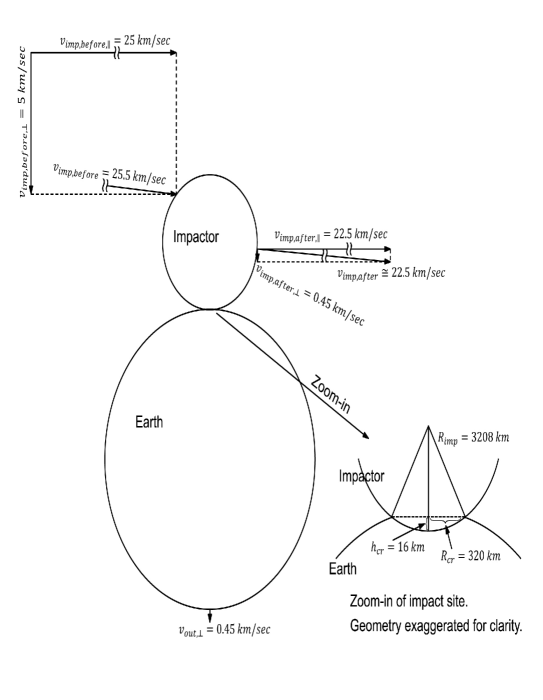
We assume that a fraction of the initial vertical-motion kinetic energy of the impactor relative to Earth will be left, after dissipation, to drive the post-impact combined motion of the impactor plus the Earth in the vertical direction. We therefore assume that immediately post impact, the impactor and the Earth have the same vertical-motion velocity , with respect to the frame of reference of the original equilibrium orbit of the Earth, whereas the pre-impact vertical velocity of the impactor with respect to the Earth is , as had been assumed previously (Figure 14).
In the following calculations, we will initially ignore the Earth’s orbital velocity of 30.5 km/sec but will in the end make an estimate of the effect of the impact on Earth’s orbit around the Sun. This is equivalent to assuming that the impactor had obtained certain degree of dynamical equilibrium within the Solar System when it reached the Earth’s location, i.e., it has a circular velocity similar to that of the Earth, apart from its peculiar velocity with respect to the Earth.
Due to the large mass of the impactor, the vertical relative speed could not have been much higher than what we had assumed below of 5 km/sec without causing further damage to both the Earth and to the impactor: We expect the impactor to have survived the impact event as well, because the Mogollon Rim in Arizona, where the impactor likely exited, has its corresponding bowl-shaped rim as well, even though not as steep as the Plateau rim on the north side, i.e., the Uinta Mountains and the Colorado Rocky Mountains where the impactor made its initial landing. Furthermore, as we had commented before, across the Plateau the minor fault lines (as well as many elongated uplifts and basins) have directions mostly aligned perpendicular to the expected trajectory of the impactor across the Plateau. This shows that the impactor most likely skidded across the Plateau from N-NE to S-SW and made an exit around the Mogollon Rim region, rather than totally evaporated during the impact process. Effectively, we assumed that that impactor was a rocky planet, which had an internal strength similar to that of the Earth, rather than being a gas planet.
In the following calculations we will also ignore the Earth’s spin velocity at its surface of 0.46 km/sec, because the effect of the Earth’s spin velocity upon the impact event will depend on the exact orientation of the impactor’s trajectory with respect to the Earth’s spin, which in turn will depend on the exact location and orientation of the Rodinia supercontinent at the time of the impact, of which we have only imprecise knowledge (i.e., certain models suggest that in late Precambrian the Rodinia supercontinent is located near the Equator, and North America is rotated 90 degrees from its current orientation). The magnitude of the Earth’s spin velocity will in any case not affect the order-of-magnitude nature of our following calculations.
Using the equations of momentum and energy conservation, and assuming the impactor has a fraction of the mass of the Earth, we have
| (5) |
and
| (6) |
The solutions of these two equations are, for the common vertical component of the exit velocity with respect to Earth’s orbit,
| (7) |
and for the fraction of energy left for driving both planets’ motion,
| (8) |
Therefore, if we choose (i.e for the impactor to have 10% of Earth’s mass, which makes it similar in mass as well in size to Planet Mars), then k=0.09, or about 9% of the impactor’s vertical-motion kinetic energy is used to produce the residual vertical motion of the Earth plus the impactor. Therefore, 91% of the impactor’s vertical motion kinetic energy relative to the Earth is dissipated during the impact event, as we had previously utilized.
Assume the impactor’s transverse velocity is originally = 25 km/sec, so that we are dealing with an oblique, or close to grazing incidence ( impact angle from the horizon). The choice of the larger transverse component of the impact velocity is first of all so that it takes into account of the slightly elongated impact crater that the Colorado Plateau is (Melosh 1996, showed in Figure 5.16 which was taken from Gault and Wedekind 1978, that until the angle of impact is close to , the crater of an oblique impact will remain fairly round. The Colorado Plateau itself, despite being slightly elongated, does have an aspect ratio fairly close to 1. So our choice of impact angle of is not unreasonable). Secondly, this choice also enabled the impactor to have enough post-impact total velocity to overcome the Earth’s gravitational field (the escape velocity from the Earth is 11.2 km/sec), as well as possibly to escape from the Solar System (the escape velocity at the Earth distance from the Sun is about 42.1 km/sec, which, if we consider adding the impactor’s post-impact velocity to the orbital velocity of the Earth around the Sun which is about 30 km/sec, then escape of the impactor from the Solar System becomes a possibility for the most favorable impact configuration. To this possibility we could also add the scenarios of the impactor running into one of the outer gas giants, or else into Venus which apparently had regenerated its crust after 500 Ma. A sling-shot acceleration scenario is also to be considered).
During the 30 seconds or so for it to reach the depth of 150 km, the impactor would have skidded within the Colorado Plateau for about 750 km, which is close to the dimension of the Plateau in the North-South direction. Of course, the initial touch-down location of the impactor could be further north, because when the contact between the impactor and Earth was initially established mostly crushing and vaporization of crust is expected, rather than the immediate dislodging of the section of the crust from the surrounding craton.
If we assume a 10% loss of the impactor’s velocity component parallel to the Earth’s surface due to friction (i.e., it should be reduced from 25 km/sec to 22.5 km/sec during the impact process), the total velocity of the impactor before and after the impact (with respect to Earth’s original circular velocity) are km/sec and km/sec, and for the Earth, the excess velocity it gained is on the order of km/sec, using equation 7. From these results we derive that the coefficient of restitution for the impact event is about 88%.
3.4 Effect on Earth’s Orbit Around the Sun
Prior to the impact, assume the Earth is on an orbit around the Sun similar to its current orbit. The mass of the Sun is g, the Sun-Earth distance is cm, and using a gravitational constant , we obtain the gravitational attraction force between the Sun and the Earth:
| (9) |
On the other hand, the average impact force can be estimated from:
| (10) |
where is the differential velocity of the impactor before and after the impact, with respect to the Earth’s original orbit. Here we assume the majority of the momentum transfer is used for altering the bulk motion of the impactor and the Earth (as our calculation in §3.5 next will show).
Taking once again the impact duration to be about 30 seconds, we obtain km/sec, therefore
| (11) |
which is significantly larger than the gravitational attraction between the Sun and the Earth. Thus, the Earth will indeed be accelerated to the terminal velocity which we had determined in §3.3.
The circular velocity of the Earth’s orbit around the Sun, on the other hand, is around 30.5 km/sec. The ratio of the after-impact velocity to pre-impact velocity is thus on the order of 1.01. The eccentricity of the Earth’s orbit is about 0.0167, and it varies historically between . Therefore, this hypothesized impact event would contribute to the Earth’s eccentricity an amount well within its normal range of variation.
3.5 Shear and Dislodging of the Colorado Plateau and of the Rodinia Supercontinent
As we have obtained previously, the average impact force, assuming a 30 second impact duration, is about dyne. From the integrity of the Colorado Plateau, it is likely that the entire Plateau block is at least partially severed from its surroundings at the time of the impact. Taking the thickness of the partially severed Plateau to be = 150 km (i.e., roughly the average thickness of the Lithosphere: here we ignore the subsequent growth in thickness of the Plateau’s root post impact, especially during the Cenozoic uplift of the Plateau when the severed Plateau mass had to achieve isostatic equilibrium by offsetting the raised height with the growth of a thickened root), we obtain that the maximum available shear stress across the boundary of the Colorado Plateau due to the impact event is on the order of
| (12) |
For the Rodinia supercontinent, assuming its severed length to be about 2000 km, and once again taking the severing depth to be = 150 km, we can similarly estimate the maximum available shear stress for rifting the Rodinia supercontinent through the impact force:
| (13) |
Therefore, we see that the maximum-available shear stresses for these two processes are comparable.
Ohnaka (2013, p.75) presented a linear relation between the shear failure strength for dry Westerly granite at room temperature, versus the normal stress , which is the same as the confining pressure, as (equation unit in MPa):
| (14) |
For higher ambient temperatures, the slope and intercept of the above equation both decrease progressively. At the deep end of the Lithosphere of 150 km, with temperature around 1000 K, the slope to use is around 0.37 and the intercept is about 50 for the above equation, according to Figure 3.11 of Ohnaka (2013). The pressure at the depth of 150 km is about 4500 MPa (i.e., assuming about 30 MPa increase in confining pressure per km increase in depth). Therefore, the shear failure strength at the boundary of the Lithosphere and Asthenosphere is about 1700 MPa (1.7 GPa), or , which is more than 5 orders of magnitude smaller than the maximum shear stress we had calculated above for the Colorado Plateau and for Rodinia during the 750 Ma event, if we assume all the impact force is used to produce the shear.
However, the assumption that the total impact force is equal to the shear force is not at all reasonable: The Earth, as we know, was (and is) totally unsupported in space apart from the gravitational attraction of the Sun which keeps it in orbit. Since the gravitational force from the Sun is much smaller than the impact force, this means that the majority of the impact force will be used to accelerate the Earth to the terminal velocity which we had calculated above according to momentum conservation. Of the total impact force, only a very small fraction acts differentially at the boundaries of the Colorado Plateau, due likely to the differential propagation time of the strain/shock waves arriving at the different locations across the Plateau’s boundary. It is this differential stress propagation that provided the shear force which led to the severing of the Plateau from the parent craton, as well as the rifting of the Rodinia supercontinent.
Furthermore, since the Colorado Plateau (as well as the Rodinia supercontinent) is not entirely severed at the time of the impact, the local shear force actually present during the impact event should be on the order of the shear strength of the material times the area of the shearing surface (which we had calculated above to be for the Plateau, and for the boundary of the Rodinia supercontinent). Therefore, the actual shear force should be on the order times smaller than the total impact force, i.e., the total shear force (on Rodinia or else on the Colorado Plateau) would be on the order of (taking the high end of the estimate to account for possible long-range correlations which give rocks in a single craton addition strength). Through the action of the initial shear force, an initial crack will be produced at the Plateau’s boundary, as well as along the eventual rifting lines of Rodinia (both east and west of the resulting central craton). Once the critical Griffith crack length is exceeded along these initial weaknesses, the cracks can also self-propagate both forward (as in the case of Rodinia) and downward (as in the case both of Rodinia and the Plateau).
With the shear strength of the Plateau region thus calculated to be about 1.7 GPa, which, incidentally, also coincides with the maximum oceanic crustal strength quoted in Price (2001, p.50), we compare it to the peak shock pressure estimated for the Santa Fe impact structure (Fackelman et al. 2008), which is about 5-10 GPa. Also for comparison, the peak shock pressure for the simulation presented by Boslough et al. 1994 is 6 Mbar, or 600 GPa, 0.1 second after impact for an assumed 10 km diameter, 20 km/sec vertical incident-velocity impactor, but it soon diffuses and dissipates into 10 bar, or 1 MPa mean stress level during the shock-wave’s subsequent propagation into the Earth’s interior. We thus see that our estimated shear strength is at least not in conflict with the inferred peak shock pressure for Santa Fe impact structure (which we will later show to be likely just a component of the 750 Ma impact crater): Since shock metamorphism is caused by the direct impact force, rather than by the differential propagation of strain waves, we expect the former to be bigger in magnitude.
Looking back at equation (2), we see that the impact process can in fact be viewed through this equation in a broad-stroked fashion: The first term is mainly responsible for the acceleration of the Earth (and the deceleration of the impactor), if we re-interpret the qualifier ”target material adjacent to the impactor” to mean the target (and the impactor) as a whole. The third term overcomes the structural strength of the Earth (as well as the impactor) to rift Rodinia and to dislodge the Colorado Plateau, as well as to produce the series of stress/strain/shock waves that created the Great Unconformity and possibly destroyed the surface layer of the impactor as well. The second term, the friction force, is partly (apart from the strength of the material) what stopped the Colorado Plateau from sinking into the mantle completely. It also encapsulates the effect of shock metamorphism, heating, etc.. Of course, the actual physical processes are distributed and convoluted, and will certainly benefit from future more sophisticated modeling and analyses. Our order of magnitude calculations in the current paper serve to establish an initial hierarchy of organization, which helps to disentangle the complicated processes of the proposed impact event, and to establish its basic plausibility.
4 Origin of the Impactor
For a Mars-sized impactor to come close to Earth’s orbit, the inevitable question is: Where did the impactor originate? Although large planetary impactors have been hypothesized in scenarios of the formation of our own moon, or else to account for the tilt of the spin axis of Uranus, these events were currently postulated to have occurred during the first few hundred million years since the formation of the Solar System. At 750 Ma, the Solar System would have already gone through more than 3.8 Gyr of evolution, thus it should have long since come into a dynamically stable configuration, at least for the giant planets (Laskar 2001). Thus, we have to expand our vision to outside of our own Solar System.
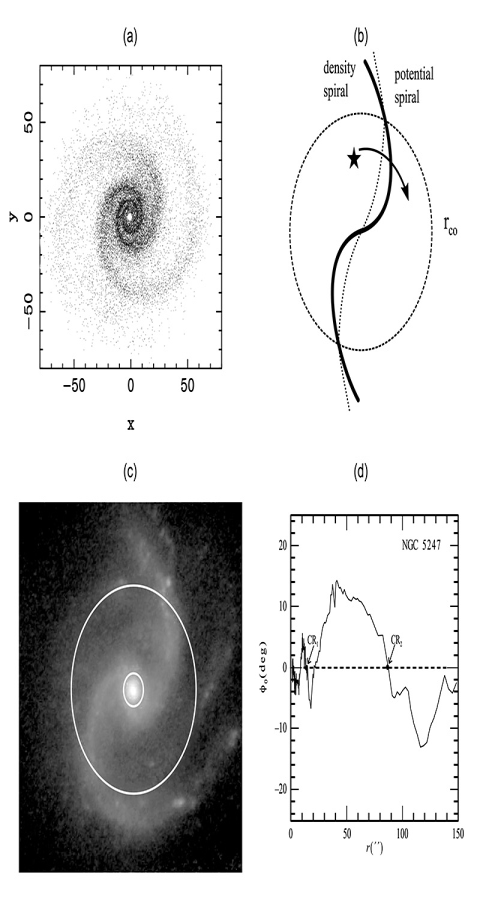
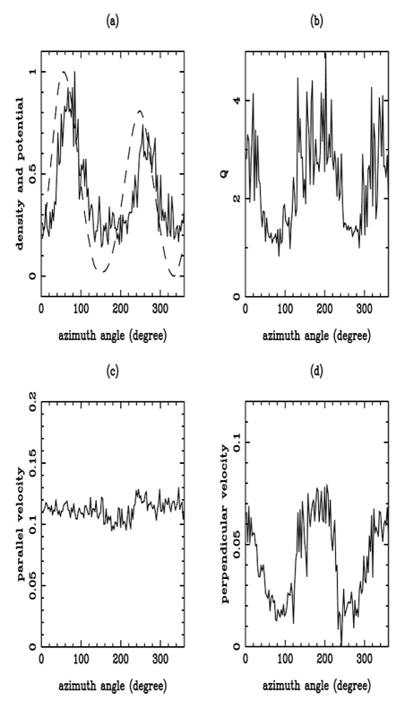
We argue that a more plausible mechanism for the generation of the impactor(s) is the encounter of our Solar System with the Galactic spiral density wave crests as the Sun orbits around the Milky Way Galaxy. Recently-advanced theories of the dynamics and evolution of spiral galaxies (Zhang 1996, 1998, 1999, 2016, 2017; Zhang and Buta 2007, 2015; and the references therein) indicate that galactic spiral arms are sites of gravitational collisionless shocks, due to an intrinsic azimuthal phase-offset between the density and potential perturbation patterns of a galactic spiral density wave mode (Figure 15 and Figure 16). This inherent phase offset leads to a temporary local gravitational instability at the spiral arms (Figure 16 Frame b), and a significant reduction of the effective mean-free-path for particle scattering at the spiral-arm instability, owing to the collective/cooperative motions of the streaming stars participating in the support of the spiral density wave mode (Zhang 1996). This cooperative behavior changes the disk galaxy from a collisionless system (Binney and Tremaine 2008) to an effective collisional (or scattering) system, with the collisional/scattering mean-free-path approximately equal to the width of the modal instability structure, which is on the order of 1 kilo-parsec (or 3 kilo-lightyears) for the Solar Neighborhood (Zhang 1996).
The presence of local gravitational instability and potential-density phase shift indicates that the spiral arms of density wave modes are themselves propagating fronts of collisionless shocks (Figure 16, especially Frame d). Since the streaming matter (i.e. stars and gas) in a galaxy disk generally rotates differentially (in the inner galaxy the matter rotates with higher angular speed than in the outer galaxy), and a single density wave mode usually rotates with a constant pattern speed which is intermediate between the angular speeds of the inner and outer galaxy disk matter (the complications of several nested density wave modes in a single galaxy, which can have multiple pattern speeds, were discussed in Zhang and Buta 2007, 2015, and shown here in Figure 15c, 15d – yet within a broad range of the galaxy’s radius there is generally still only a single mode and a single pattern speed of the wave mode), within the so-called Corotation Radius of the mode (where the wave and the disk matter rotate at the same speed) the streaming disk matter experiences excess compression while crossing (or over-taking) the spiral arms (Zhang 1996; Figure 15b). This gravitational-instability effect due to the nonlocality of the field (i.e., potential and density not being aligned as a result of the presence of the phase shift) can both directly perturb the stellar orbit, and also trigger the formation of massive stars. These massive stars evolve quickly and die in spectacular explosions as supernovae. The blastwave of a supernova (a rapidly expanding shock wave of material consisting of the majority of the mass of the original exploding star) can further perturb the orbits of nearby stellar and planetary objects, or else can lead to the formation of new objects out of the debris material, which may acquire significant peculiar velocities. All of the above-mentioned perturbative effects can lead to the formation of rogue exoplanets, which have the potential to invade into the inner confines of our Solar System. One possible candidate for such an invader in our present Solar System is dwarf planet Pluto, which has a moderately eccentric and inclined orbit, and which has its spin axis in gross misalignment with respect to the orbital plane of the majority of the giant planets (except Uranus) in the Solar System. Other possible invisible intruders that lie outside the observed edge of our Solar System may manifest as gravitational perturbations to the outer giant planets’ orbits, as recent observations seem to indicate.
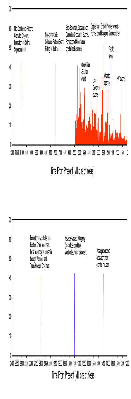
In Figure 17, we present a compiled graph of previously published data on both the largest extinction events on Earth during the Phanerozoic Eon (red histogram, with relative intensity scales), as well as known major tectonic events throughout Cambrian and Precambrian periods (blue lines, scale not calibrated). We see from this figure that the approximate period of the largest extinction events during the Phanerozoic Eon (especially the clustering of these events) is about 250 million years. This period is also close to the spacing of the major tectonic events in the last segment of the Precambrian. Our 750 Ma event continues this quasi-periodic trend, even though at this Precambrian epoch there was not yet hard-bodied fossil record of complex organisms. The spacings of the blue lines are seen to increase to about 300-400 Ma towards earlier Precambrian, which is expected if the Solar system lied further out in the Milky Way Galaxy at that time, and migrated slowly inward with time with reduced period (Zhang 2017).
In what follows, we show that the approximate period of 250 million years for Earth’s major tectonic and extinction events in the Phanerozoic and late Precambrian, is similar to the present period that the Solar System encounters a Galactic spiral density wave arm or spur. We assume that the Milky Way has a two-armed spiral structure (Fux 1997, 1999 and the references there in), which is common along all of the observed disk galaxies (the occasionally reported 4-armed spiral structure for our Galaxy may simply have counted the inter-arm spurs as major spiral arms, or else have counted the response of the gas to a two-arm spiral potential forcing, and these spurs could lead to the minor peaks in the extinction/tectonic event plot. Other peaks of the extinction plot may also be related to the Suns periodic crossing of the Galactic plane in the vertical direction). Using a pattern speed for the Galactic spiral structure of km/sec/kpc, and the circular speed of stars at the Solar neighborhood of (assuming the Sun’s location in the Galaxy is 8.5 kpc from the Galactic Center, and its circular speed around the center of the Galaxy is 220 km/sec, Binney and Tremaine 2008), we obtain (for two-armed spiral) that , or that the spiral-crossing period is similar to the Galactic Year at the Solar radius. These facts lend support to the idea that the Galactic environment might have provided periodic sources of impactors to power both the major extinction events, as well as major plate-tectonic events, on Earth. Other Solar-System giant planets might have experienced similar giant impact events as well. For example, Venus is known to have a young crust of around 500 million years, and its spin is in the opposite direction to its orbital motion. Another well-known example is Uranus, which has its spin axis tilted 90 degrees from the plane of the Solar System (which is itself roughly aligned with the plane of Galactic rotation). Mars and Saturn have moderate levels of spin-axis tilt, similar in amount to the tilt of Earth’s spin axis.
Because the spiral arms or spurs in galaxies have finite width, multiple impactors produced during the same spiral-arm crossing episode of the Solar System can invade Earth’s orbit during a short (from a geological standpoint) period of time. This may explain the near coincidence in time of the occurrences of the Decaan Traps in India and the Chicxulub Crater in the Yucatan, which are both dated to the K/T (or K/Pg) boundary but are spatially separated; or else the near coincidence in time of the formation of Emeishan Traps in China and the Siberian Traps in Russia during the late-Permian/early-Triassic period, with period also coinciding with the end-of-Permian mass extinction event and the completion of the assembly of the Pangaea supercontinent (Stow 2010; Wignall 2015). On the extinction-intensity plot (Figure 17), this trend shows up as closely grouped major extinction events, around especially 250 Ma and 500 Ma.
One potential issue with this proposal is the phase of the Sun relative to the spiral arms of our Galaxy, which, depending on the model used, may not always put the Sun near a major spiral arm at the current epoch. This phase offset could be accounted for in several ways. (1). There is the time needed to form new massive stars after an arm crossing, and for stellar evolution to carry the massive stars into the stage to produce new supernova. (2). Depending on the peculiar velocity acquired by the rogue planet, it takes time for it to reach the outer confines of our Solar System. (3). It takes time to gradually dissipate the noncircular component of the exoplanet’s velocity when it starts to participate in the Solar System’s motion. This dissipation is possible because of the known result that a system naturally evolves towards the configuration of lowest energy, which, for a disk configuration, is that of a circular orbit for given amount of angular momentum (Lynden-Bell and Kalnajs 1972). (4). Over an even longer time period, the inner and out disk will exchange angular momentum as well, so inside corotation the mean orbital radius of a planet will decay secularly, and outside corotation the orbital radius of a planet generally increases. Depending on the particular entry parameters of the rogue planet, these dissipative and secular evolutionary effects may bring it gradually to near-Earth orbit with a grazing impact condition. This scenario, of course, may not be realized for every intruder into the Solar System. Even if a possible invader, such as Pluto, had reached the outer Solar System, it may take tens or event hundreds of millions of years for it to cause a giant impact event on Earth (or on another giant planet of our Solar System), if at all.
For now, We can at least take face value of the statistical correlation of the period of the major extinction events, as well as the period or half-period of the supercontinental cycle, with the period of the Galactic spiral-arm-crossing at the Sun’s orbital radius, and say that there is now a plausible source for large impactors from our Galactic environment, and the supply of these impactors can occur with a period similar to the observed period of major extinction and tectonic events on Earth.
The recent discovery by European Space Agency’s Gaia satellite that Gliese 710, a star which is about 60% as massive as the Sun, is likely to have a close encounter (to the distance of the Oort Cloud) with our Solar System in the next 1-2 million years (Bailer-Jones et al. 2018); as well as another inferred possible close encounter of our Sun with the binary system Scholz’s star 70,000 years ago (Mamajek et al. 2015), shows that we indeed cannot regard galaxies, especially our own Milky Way, as collisionless systems (in galactic dynamics, a collisionless galactic system includes no binary close encounter or scattering, as well as no head-on collision), and the spiral density wave modes in galaxies are the most likely provider of gravitational perturbations to invalidate the collisionless assumption.
5 Further Supporting Evidence
5.1 Age Determination, Contact Relationship, and Deformation History for Precambrian Rocks in the Colorado Plateau Area
Much of the Colorado Plateau interior is covered with sedimentary rocks of the Phanerozoic Eon, which makes discerning of the effect of earlier processes difficult. However, there exist significant outcrops of Precambrain rocks, mostly along major faults in the Plateau’s boundaries, as well as along isolated interior faults (such as the Grand Canyon Inner Gorge). See, for example, the Geologic Atlas of the Rocky Mountain Region (1972).
For the purpose of substantiating the 750 Ma impact event, we would like to identify the top layers of the surviving lithology right after the impact, in order to gather evidence for impact-induced alteration and movement in these Precambrian rocks.
The outcrops we are most interested in, first of all, consist of the Proterozoic quartzite, slate, and other meta-sedimentary rocks of the so-called “cover sequence”, which invariably lack hard-body fossils. Accurate dating of such meta-sedimentary rocks on the Plateau had been carried out most successfully for the Chuar Group of the Grand Canyon Supergroup (Karlstrom et al. 2000), as well as for the Uinta Mountain Group and its western extension the Big Cottonwood Formation (Dehler et al. 2005, 2010). Neoproterozoic ages of 740-770 Ma have been obtained for the youngest sediments of both of these groups.
Erslev et al. (2004) have dated K-feldspar in pegmatite dikes in the southern Sangre de Cristo Mountains, and have found components with ages between 600-800 Ma, which they attributed to the breakup of the Rodinia.
For the Uncompahgre Formation of the western Colorado, on the other hand, less certain age assignments have been obtained. Although Paleoproterozoic depositional ages have been obtained for certain horizons of the Uncompahgre Formation (see, e.g. Karlstrom et al. 2017 and the references therein), signals of younger Precambrian ages in fact have been found when analyzing the samples of Uncompahgre Formation of the Needle Mountains (Dean 2004; Wu 2007). However, in these instances the data points showing younger ages were treated as spurious and incompatible with the age constraints set by previous workers (i.e., Barker 1969), who first proposed that the Uncompahgre Formation must be older than the intruding Eolus Granite (circa 1.4 Ga in age) with which it is in contact with in the Needle Mountains area of Colorado. Barker, to be sure, did highlight a so-called “Uncompahgre disturbance” event, responsible for the intense folding and attendant low-to-high rank metamorphism of the Needle Mountains rocks, which occurred at an unspecified time after the deposition of the Uncompahgre Formation.
From our previous discussions, we see that this “Uncompahgre disturbance” event discussed by Barker is likely the giant impact event at the 750 Ma, which is seen to have scrambled together fragments the basement and the cover sequence rocks, as well as the Eolus Granite. It also produced conglomerates (i.e. in the Vallecito Reservoir area) consisting of material from all the Precambrian rocks. Therefore, the Uncompahgre disturbance necessarily happened AFTER the intrusion of the Eolus Granite at 1.4 Ga.
Since the proposed event had thrown entire mountains of Uncompahgre Formation as well as parts of the Irving Formation of the basement rocks upon and around the Needle Mountains Eolus plutons (as evidenced by the upturned morphology of rocks making up the entire Grenadier Range in Needle Mountains) , we no longer have the need to interpret the contact between these country rocks and the Eolus Granite as intrusive, though this does not exclude the possibility that certain segments of the contact could be the original intrusive contact. We want (and need only) to demonstrate the fault contact nature of portions of Uncompahgre Formation with Eolus, so as to assert that higher horizons of Uncompahgre Formation COULD BE younger than the Eolus intrusion age of 1.4 Ga, even if these horizons in Uncompahgre Formation had since been lost through either impact vaporization or later erosion, or else lay in remote eegions of the Colorado Plateau awaiting further dating analyses. This expectation is only reasonable given that the Plateau region was flat during the time of the proposed impact (Blakey and Ranney 2008, 2018), so the Neoproterozoic sediments discovered in Arizona and Utah SHOULD have existed also in Colorado, and in New Mexico.
We stress that the reviously observed gradient in metamorphic grade of Uncompahgre Formation and Irving Formation in proximity to the Eolus contact (Noel 2002; Deen 2004; Wu 2007), which was used partly to establish the intrusive-contact nature between Eolus and Uncompahgre, could just as well be a result of dynamics/pressure-induced metamorphism (or else a result of dynamics-induced thermal effect, rather than granite-intrusion-induced thermal effect), due to the impactor’s forcing (i.e. ramming) of these transported country rocks into contact with the preexisting Eolus. The syclinorium shape of the Uncompahgre Formation north of the Eolus Granite Plutons supports such a scenario, as is the determination (Dean 2004; Wu 2007) that the metamorphism of Uncompahgre in this region occurred at the same time as its structural change (i.e., the intense folding to conform to the shape of the outer contours of the Eolus pluton). This newly proposed scenario also alleviated the difficulty in interpreting the Noel (2002) observation that the foliations of Irving Formation, which are in the eastern contact of Eolus Batholith with the Vallecito River Valley, appear to have developed during contact metamorphism (since they are defined by sillimanite and hornblende), yet are east-west striking and subvertical, and transect the contact with Eolus pluton at a high angle, thus cannot have developed due to ballooning of the pluton. If such foliation developed through impact-induced dynamical metamorphism during the impactor’s traverse from north to south, these observed features would be naturally explained.
Furthermore, since Dean (2004) and Wu (2007) had both demonstrated the correlation of macroscopic deformation and microscopic metamorphism of the Uncompahgre rocks in this region, we expect the same gradient in the degree of metamorphism to hold also for a segment of the Uncompahgre Formation synclinorium next to the Twilight Gneiss in the northwestern region of the Needle Moubtains (Zinsser 2006, Figure 2). The laboratory demonstration of this prediction will confirm the role of dynamical metamorphism without the need for Eolus granite to create contact aureole and thermal metamorphism. The “slapping on” interpretation of the origin of some of the country rocks around Eolus Granite revives the original proposal of Cross et al. (1905) that some of the contacts between Eolus and country rocks are faults. The possible ductile shear contact between Uncompahgre Formation and Irving formation in western Needle Mountains was also the original motivation of Tewksbury (1985a) to interpret Uncompahgre Formation as allochthonous. Grambling et al. (1989., p. 91) report cases in southern Sangre de Cristo mountains where the contact between Mesoproterozoic granites and country rocks show no contact aureole, and one apparently shearing contact separates rocks which differ by 6 kbar in peak metamorphic pressure.
A significant portion of the distortions of the Uncompahgre and Irving Formations in Needle Mountains is north-south shortening, east-west extension (Harris 1990; Gonzales et al. 1996; Noel 2002; Zinsser 2006). This is irrespective of whether the country rocks are located to the north, south, east, or west of the Eolus Granite formations. This shows that the disturbance that created these distortions cannot be due to the ballooning of the Eolus granite, as many previous studies have assumed, but rather is on a scale much larger than the Needle Mountains. Furthermore, in the Uncompahgre Gorge region, the distortion to the lithologies and the type of dynamical metamorphism in cover sequence rock appear to continue that of the Needle Mountains (Harris 1990; Wu 2007). Since the Gorge is many tens of kilometers away from the influence of the Eolus intrusion, it is impossible to attribute these signatures of dynamical metamorphism (i.e., two distinct sizes of quartz grains, with the smaller ones attributed to the newer dynamical disturbance) to the intrusion of Eolus Granite. On the other hand, the giant impact scenario can easily account for the similarity of distortions in cover sequence rocks in these two areas.
The giant impact scenario can also account for the polyphase deformation scenario porposed in Harris et al. (1987) and Harris (1990): During the impactor’s initial touch-down, it vaporized the top-most layers of sediments, and also created a kind of domino-effect and pushed cover-sequence rocks northward in spreading layers, in what Harris et al. (1987) called “north-directed, thin-skinned thrusting”. Subsequently, the impactor traversed southwestward, which generated vertical folds, and pushed the rocks southward against the Eolus Granite, which further distorted these folds. Harris (1990) emphasized the continuity of the three phases of deformation found in the cover sequence. Harris et al. (1987) also considered the possibility that some of the deformation could have occurred post Eolus intrusion.
We quote here also a passage from Baars (2000, p.117) in his discussion of the Uncompahgre Formation in the western San Juan Mountains: “Sometime after the sediments were deposited, but before Paleozoic events began the sedimentary layers were altered somewhat to form quartzites, which are highly cemented sandstones, and slates, which are slightly metamorphosed shales. The degree of alteration was only slight when compared to the older basement complex, but the thick deposits of sedimentary rocks are in rather poor condition when compared to the younger Paleozoic strata. The younger Precambrian sequence is called the Uncompahgre Formation for exposures of the highly folded strata in Uncompahgre Canyon immediately south of Ouray. The formation may be approximately the same age as the Grand Canyon series of red beds, which are sandwiched between the Vishnu Shist and Tapeats Sandstone in the depth of the Grand Canyon. However, many geologists who have studied the two areas believe that the Uncompahgre is somewhat the older, as it is more highly metamorphosed than the Grand Canyon sequence. This may have resulted from a more severe history of tectonic activity (mountain building) in the San Juans, however, and may reflect nothing about the relative ages of the two units”.
So, it is clear that some previous-generation geologists had in fact speculated on the possibility that the metasedimentary rocks across the Colorado Plateau are contemporaneous, which makes sense because these sediments originated from the same shallow-sea environment, and reached similar deposition depth of several kilometers (Baars 2000, p. 117), before apparently suffering the 750 Ma impact event which led to their varying degrees of metamorphism and folding (the exact degree of metamorphism would depend in part on their relation to an existing or newly created fault, as well as on the location with respect to impactor’s trajectory and surface topography), as well as material loss through vaporization. Subsequently, the upturned and folded quartzites and slates also suffered differing degrees of erosion, during repeated faulting actions throughout the phanerozoic eon (Baars 2000, p. 119-121). For example, the uplift and erosion experienced in the Colorado Front Range, along the Plateau’s northeastern boundary, are significantly more than in the Plateau’s western boundary.
The post-Eolus giant impact event also helps to resolve the apparent conflict between the need to create synmagmatic strain field involving N-S contraction and E-W extension to account for the deformation characteristics of the Proterozoic country rocks around Needle Mountains pluton (Gonzales et al. 1996), and the internal characteristics of many of the 1.4 Ga plutons in southern Laurentia (of which Eolus is a typical member), i.e., being of A-type chemistry or being anorogenic, which implies that these plutons should have been emplaced in an extensional, or rifting, environment (Anderson 1983; Hoffman 1989). The impact scenario can also easily account for the fact that many of the Mesoproterozoic anorogenic rocks in the southern Rocky Mountains area are moderately to intensely foliated: “The foliations are solid-state deformational fabrics, and in places the foliated middle Proterozoic plutons are separated by shear zones from supracrustal rocks lacking any contact metamorphic overprint. One is left with the suspicion that a major component of ductile deformation occurred more recently than 1500 Ma in areas as widely separated as central Colorado and Central New Mexico” (Grambling and Tewksbury 1989). We would certainly agree!
5.2 Breakup of Rodinia Supercontinent
We have previously commented that on the western part of the Rodinia Supercontinent, the 750 Ma impact event likely caused the rifting of Australia and East Antarctica from the proto-North-America continent Laurentia (Moores 1991). The hingeline of this separation on the North American Continent is located in Idaho, Oregon, eastern Washington, as well as in western Canada along the western front of the Canadian Rockies. It is also responsible for the dislodging of the Colorado Plateau from its surrounding craton, as well as for creating a multitude of weaknesses in the Plateau’s basement, causing the eventual formation of the Colorado River system, among other things. In corresponding regions of Tasmania, Australia, Proterozoic sediments similar to that in the Grand Canyon region of the U.S. had been identified in recent years (Mulder et al. 2918).
The damage to the Rodinia Supercontinent, furthermore, is not limited to its western regions. On the eastern side of the Rodinia supercontinent, close to the present Appalachian Mountain chains, evidence of a similar continental breakup is also abundant. In Figures 18, 19, the Neoproterozoic suevite/conglomerate formations in the Grandfather Mountain region of North Carolina are shown, with evidence for impact melting and fusing prominently displayed. Plutonic rocks with ages dated to be close to 750 Ma have also been extensively studied (King and Ferguson 1960; Su et al. 1994; Goldberg et al. 1986; Ownby et al. 2004). Figure 20 shows possible impact shock metamorphism signature in Precambrian rocks off the Skyline Drive in Shenandoah Mountains area of Virginia.
Additional evidence of the breakup of Rodina is abundant from the west side of the original supercontinent. Figure 21, Top Frame shows a giant block of Neoproterozoic igneous intrusion (dated to about 750 Ma, see Gadd 2008) into metamorphosed Archean rocks (Bottom Frame, and part of the metamorphic effect may have occurred during the 750 Ma event), near Toad River Bridge along the Alaska Highway, in British Columbia, Canada.
The breakup of the Rodinia Supercontinent eventually led to the formation of two subsets of supercontinents Gondwana and Laurentia, as well as the formation of the proto-Atlantic Ocean, the Iapetus Ocean (Blakey and Ranney 2018). These breakups, apart from owing to weaknesses in the Lithosphere created by the impact, may also had been affected by the global isostasy effect which leads to the major redistribution of landmass, aided by the low viscosity zone between the lithosphere and asthenosphere (more on that in §6), which could account for the apparent delay between the timing of shock metamorphism and igneous activity signatures (0.7-0.8 Ga) and the timing of the actual rifting (0.6-0.7 Ga) of the different regions of the Rodinia supercontinent.
The coordinated rifting of the entire Rodinia Supercontinent at around 750 Ma, especially the synchronized igneous activities across the continent, shows that the impact force involved must be great enough to affect the whole Earth simultaneously, another piece of strong evidence in support of a giant impact scenario.
5.3 Formation of the Great Unconformity
The dislodged Colorado Plateau did not start its uplift right away, due to the confining pressure from its surroundings. Therefore, immediately after the impact a flattened landscape should have existed at the Plateau region, due mostly to impact-induced evaporation of material. This flattened landscape in late Precambrian and early Cambrian was confirmed in the paleo-geological maps of Blakey and Ranney (2018) for that time period. Apart from residual crushed material post impact there was no tall mountains to erode, and no significant re-sedimentation after 750 Ma, until the beginning of the Cambrian (540 Ma) for most regions, though in some area detritus classified as Cryogenian (circa 635 Ma) was also found. This explains the widespread occurrence of the Great Unconformity, the exact age gap of which depends on the locale such unconformity is observed (i.e., the actual age gap for each region depends on how much of the Precambrian cover sequence or even basement rocks were removed during the impact event, and how soon the surrounding topography and other environmental conditions work together to allow regional sedimentation to re-start).
As we had mentioned before in this paper, in many regions of the Colorado Plateau, the Cambrian sediments immediately above the Precambrian top layer appear to be re-lithified remains of charred and melted Precambrian fragments derived locally (see, e.g. Figure 2). Thus there is some leeway in the accurate assignment of ages to these recycled local rocks, since the component material had presumably been sitting there from 750 Ma until the epoch when re-lithification had bounded the fragments, according to the scenario presented in this paper. Other forms of presumed impact detritus in the Plateau area and its surroundings are pebble, cobbles, boulders and various forms of conglomerates made from Precambrian material sourced either locally or from a distance region (Condon 1995).
The varying degrees of age and metamorphism for the upper layers of the exposed Precambrian metasediments across the Plateau and in the northern Rocky Mountains likely reflect their varying locations during the impact event, with the fault-protected units (i.e., the Grand Canyon Supergroup), or area away from the direct impact crater (i.e. the Belt series in the norther Rockies) avoiding high-grade metamorphism as well as impact-induced evaporation, whereas most of the Uncompahgre Formation of the San Juan Mountains apparently suffered both a higher degree of impact shock metamorphism (Baars 2000, pp. 117-119), as well as uplift-induced subsequent erosion. On the other hand, near the Flaming Gorge area in Utah, the degree of metamorphism of the Uinta Mountain Group rocks within the same horizon can change drastically within a short distance, due possibly to the differing positions of the rocks with respect to the local faults and shock wave propagation (the Uinta Mountain front lies in the area where the impactor is expected to have made the initial substantial contact with the Earth’s crust).
Further north from the Colorado Plateau, in Wyoming, younger Precambrian quartzite cobbles and pebbles litter the basin of Teton Village and Jackson Hole community. Love et al. (2003, p. 59) stated that these quartzite pebbles do not have a local source, and they appeared similar to the metamorphosed Proterozoic sedimentary rocks in southwest Montana and nearby parts of Idaho. It is possible that in these northern neighborhoods of the Colorado Plateau, some of the quartzite pebbles may have been thrown out of the impact crater (i.e., the Colorado Plateau), which would explain the nonlocal nature of the quartzite pebbles in the Jackson Hole area. Similar types of pebbles are also found on the Plateau itself (Condon 1995), for example in the Vallecito Creek area of Needle Mountains. One might question whether the current distance of the Jackson Hole area to the boundary of the (traditionally defined) Colorado Plateau might be too far for this scenario to be possible. Here we must take into account that the Basin-and-Range extension dynamics since the Cenozoic Era has led to enlargement of the distance between landmarks by about a factor of two, and the Yellowstone-Teton-Snake River Basin area has been shown to be fully affected by such extension dynamics, just as in the neighboring Nevada. Once this is taken into account, the distances involved become entirely within the dimensions of impact-excavated crater outer rims (Dence et al. 1977; Melosh 1996). Furthermore, Dutton (1882)’s original consideration to include part of the Rocky Mountains north of the Uinta Uplift into the definition of the Colorado Plateau may reflect the fact that this northern addition to the Plateau (put into its right place before the Basin and Range extension dynamics had stretched it northwestward) could be the initial touch-down area of the impactor. The fact that in an oblique impact event the uprange jet in the rear of the impactor is much more powerful than the down range jet in front of the impactor (Melosh 1996, p.49) could account for the fact that the most numerous cobbles and pebbles of Neoproterozoic age are found in the northern direction of the Plateau (i.e. in Wyoming).
5.4 Spin-Axis Tilt and Polar Wander
It is well known that the Earth’s spin axis is tilted from the orbit plane of the Earth in the Solar System by about 23.5o. From angular momentum considerations, the Earth’s spin axis is expected to be aligned with its orbital angular momentum axis at birth, so the tilt of the spin axis of the Earth is likely produced by later catastrophic events, such as giant impacts.
If this has been the case, the currently measured spin-axis tilt would be the cumulative effect of multiple past impacts. Since the directions of these past impact events are uncorrelated, the additional contribution to the total tilt amount by each impact event should sometimes reinforce one another and sometimes cancel. Still, we want to look into whether a giant impact of the magnitude proposed in the current paper would produce an incremental tilt smaller than or on the order of the currently-observed spin axis tilt of the Earth, since if the proposed event had instead produced an exorbitant amount of additional tilt, then the likelihood of such a scenario is more in doubt.
The spin of the Earth corresponds to a surface rotational speed at the equator of 0.46 km/sec. As a result of the proposed 750 Ma impact event, the impactor’s velocity in the tangential direction (i.e., parallel to the surface of the Earth) was reduced by about 10% of its initial value (i.e. to 22.5 km/sec from the initial 25 km/sec, see §3.3). Since the impactor’s mass is about 10% of the Earth’s mass, we expect the Earth’s surface velocity change to be on the order of 0.2 km/sec, from momentum transfer consideration. Thus the proposed event is of the correct magnitude to be able to produce a 23 degree tilt of the Earth’s spin axis, with the quantitative result depending on the actual orientation of the impactor’s trajectory with respect to the Earth’s spin direction at the epoch of impact (i.e., we need to consider vector addition of the angular momentum of the original spin and the excess spin due to impact. An accurate account will also need to consider the mass distribution of the whole Earth). The reasonableness of the proposed impact scenario is nonetheless reinforced by the past numerical simulations of the formation of our Moon (Benz et al. 1986,1987,1989; Cameron and Benz 1991; Reufer et al. 2012; Canup 2012; Wyatt et al. 2016; and the references therein), which normally assumed a Mars-sized impactor on the proto-Earth, and which also succeeded in reproducing the current tilt of the Earth’s spin axis. Of course, many such impact events were likely to have occurred in the Earth’s history, and the current tilt axis of the Earth reflects the net effect of all such impact events in the Earth’s history. Another point of reference is that Neptune has its spin axis almost at 90 degrees to its orbital angular momentum plane around the Sun. This is usually reproduced in numerical simulations by an assuming an Earth-sized impactor which hit Neptune early in the history of the Solar System.
Besides changing the Earth’s spin-axis tilt and producing true polar drift in space, the past impact events were likely to be responsible for producing the (apparent) polar wandering phenomena of the Earth. Wegener himself had already commented on the possible correlation between polar wandering and the redistribution of the continental mass in his monograph (Wegener 1929).
5.5 “Snowball Earth” and Origin of Certain “Dropstones”
Giant impact events are expected produce dusty atmosphere which prevents sunlight from reaching the Earth’s surface for prolonged periods of time . The well-known correlation of “Snowball Earth” (continental-scale glaciation) episodes with mass extinction episodes lends support to the idea that giant impacts could be the simultaneous trigger of both Snowball Earth and major mass extinction events.
A well-known episode of Snowball Earth event occurred after the breakup of Rodinia, between the time period of 720 Ma and 635 Ma. On Antelope Island within the Great Salt Lake of Utah, evidence of this great continental glaciation period have been well preserved (Hayes et al. 2013 and the references therein). Previously, many of the conglomerate formations have been interpreted as “dropstones” deposited by advancing and retreating glaciers of the Cryogenian era (i.e. between 720 - 635 Ma), after the Rodinia breakup. These conglomerate formation are also found further north up to regions of Canada. However, closer examination shows that a significant portion of these conglomerates are likely to be giant-impact induced, rather than formed as a result of glacial deposit and compactification. An example in favor of this interpretation is shown in Figure 22, where clear signature of impact melt is displayed within the matrix of a giant slab of Neoproterozoic conglomerate located in the northern end of the Antelope Island State Park, Utah.
6 Broader Implications
6.1 Multiple Giant Impacts in the Earth’s History
The proposed giant impact event at 750 Ma centered on the Colorado Plateau is only one example of such giant impacts which might have occurred multiple times during Earth’s history, starting from the well-established Formation-of-the-Moon episode which was commonly believed to have occurred during the Earth’s infancy. As noted early on by T.C Chamberlin, and quoted in Van Hise and Leith (1909): “The groups Paleozoic, Mesozoic, and Cenozoic are not, in the conception of some of us, defined by a distinct kind of life, as in the case pf some of the minor horizons, for the life fits better the idea of a gradation than of a distinct separation. These great divisions are rather, as I see it, at least, great historic movements fundamentally dependent on dynamic events, than paleontological divisions. Originally they were supposed to be separated by universal catastrophes to life, and their distinctness was due rather to the intervention of the catastrophe than to the different quality of the life, which is merely seized upon as a characteristic suited to nomenclature.” The episodic nature of the major tectonic and extinction events graphed previously in Figure 17 lends support to such multiple-giant-impact viewpoint. The well-known distribution pattern of sediments across stage boundaries, i.e., starting from coarse conglomerates, refining gradually upward, is also an indirect support for the giant impact interpretation.
A well-known and well-studied example of a major impact event is the Sudbury Impact Crater in Ontario, Canada (see the many contributions in Dressler and Sharpton 2000), which has an estimated age of 1.85 Ga. The original (before modification) size of the crater was estimated to be 130 km. The Sudbury impact crater is the third-largest on Earth, after the 300 km Vredefort crater in South Africa, and the 150 km Chicxulub crater under Yucatán, Mexico (these rankings were of course made before the proposed Colorado Plateau impact crater with diameter of 640 km). Shatter cones and shock-altered quartz crystals were found in the Sudbury Basin area. The original crater had gone through tectonic alterations since its initial formation, the most notable of which is the circa 1.1 Ga Grenville Orogeny. Even though the impact-altered rocks and the tectonically-altered rocks partially overlap in their geographical location, the signatures of these two kinds of processes are distinctly different. The Left and Right Frames of Figure 23 show examples of rocks in the Sudbury area, that were affected predominantly by each one of the above two processes. We can see clearly that the rock alterations in the Colorado Plateau area, which we had presented previously in especially Figure 3 and Figures 5 - 9, more closely resemble the impact-altered rocks in the Sudbury area, rather than the tectonically altered rocks (produced during the Grenville Orogeny) in the eastern outskirts of the Sudbury Basin. In essence, the difference is partly that of brittle deformation versus ductile deformation, and partly impact-induced partial melting and shock metamorphism, which do not show up in tectonically induced deformation.
Another giant impact event, also with a Mars-sized impactor, had previously been proposed for the Pacific Ocean region during the mid-Jurassic epoch (H. Zhang 1998, 2016; H. Zhang et al. 2013; Li et al. 2014), with evidence across the Pacific Rim both in the Asian countries, especially in the east coast of China (i.e., the Yan-Shan Movement), as well as in the west coast of the US and Canada (i.e., the formation of the Franciscan Melange and the initiation of Nevadan Orogeny).
The Jurassic giant-impact event in the Pacific, in addition to causing widespread deformation on land across the Pacific Rim, was likely responsible also for initiating the shrinking of the Pacific Ocean (through the breakup of its original oceanic plate and the subsequent regrowth of the ocean floors), which in turn might have been responsible in part for the opening up of the Atlantic Ocean, which continues to this day, and for the initiation of the Basin and Range movement in western US as well as in eastern China.
We propose therefore that the kinematic effect of a giant impact, as well as the gravitational equilibrating effect of the displaced continental material, may serve as major driving forces in the post-impact evolution of the Earth’s tectonic plates, in addition to the traditionally attributed slab pull, ridge push, as well as other thermal and dynamical driving forces (see, for example, Price 2001 and the references therein). This newly realized importance of global isostasy (i.e. the tendency for continental plates to achieve global dynamical equilibrium by moving in the horizontal directions on a spherical Earth’s surface), means that we may have come full circle in understanding the origin of Earth’s geomorphology: Instead of plates being pushed around by convection currents from underneath, the gravitational and kinematic interactions of plates from above, as a result of giant-impact-induced mass and energy re-distribution, may be the major driving engine for continental drift.
6.2 Mantle Convection and Plumes
What then about the currently-popular mantle convection and mantle plume picture? The history of the emergence of this picture is well documented in Sullivan (1991), chapter 5 “The Mantle Controversy”. The entire picture was adopted not because of overwhelming evidence in support of it, but rather, giving the overwhelming evidence in support of plate motion, and the lack of a suitable candidate mechanism for driving this motion, the mantle convection was forced onto the stage in an act of desperation.
In fact, even at the time of inception of the mantle convection proposal, much evidence went against it, as quoted in Sullivan (1991). Gordon MacDonald, in particular, presented ample evidence for a rigid interior of the Earth, and that as a result much larger temperature gradient needed than observed is needed to drive any global-scale mantle convection. Taking “realistic values” for the plasticity of the interior, MacDonald said, “we see that the thermal requirements of convection in the mantle are so severe that the hypothesis can be dismissed”.
Sullivan quoted also a paper by Bullard et al. (1956), early proponents of the mantle convection mechanism for generating the heat flow which was observed from ocean floor: “In brief”, they wrote, “it seems not impossible that the objections to the existence of convection currents in the mantle can be overcome by reasonable assumptions about the properties of the material of which it is composed. That the mantle does really possess these properties is not self-evident. In fact, the main reason for supposing that it does is the desire to have convection currents to account for the oceanic heat flow.”
Decades later, we are nowhere closer to confirming the properties of the mantle that would support a continent-wide convection current. The mantle plume variation to account for the heat emanating from certain openings in the Earth’s crust, on the other hand, can be countered by a “chicken and egg” type of argument, i.e., some of the heat flows above triple junctions could be results of continental rifting, rather than the cause of it.
Given the likelihood of giant impacts in the Earth’s history, and their effectiveness in driving both the initial rift and the subsequent redistribution of landmass through gravitational force, the lack-of-viable-driving-mechanism is not longer a viable argument in favor of mantle convection and its variations to serve as major driving forces. Even if some redistribution of mantle material does occur, this is now seen to be more likely a result of the redistribution of continental mass, not the cause of it. Even the heat flow observed through the continental and oceanic crust, could have been generated by the frictional force of the continental motion, initially set off by the giant impacts.
7 Conclusions
We have proposed and demonstrated that a diverse range of geomorphological features of the Colorado Plateau can be naturally accounted for if they are the results and aftermath of a giant impact event hypothesized to have occurred around 750 Ma. These features include: (1) The surprising structural integrity of the Plateau during the past 600 Ma, despite the vigorous igneous and orogenic activities at its boundaries; (2) The occurrence of the so-called “Great Unconformity” throughout the Plateau region, as well as elsewhere in the world, surrounding the period of the proposed impact event; (3) The wedged insertion of large chunks of the late-Precambrian Grand Canyon Supergroup sedimentation sequence into the basement rocks of the Vishnu Complex, as well as the similarity in age of the upper-most deposition layer of the Supergroup (the Chuar Group) to the timing of rifting of the Rodinia supercontinent around 750 Ma from the Plateau’s western edge, as well as the subsequent rifting of Rodinia along the present east coast of North America continent; (4) The Plateau-wide presence of metamorphosed late-Precambrian sediments which often display evidence of melt and shock metamorphism; (5) The thick basalt dikes cutting through basement rocks on the Plateau, as well as further north in the central and northern Rocky Mountains, which can be dated to about 750 Ma; (6) The Plateau-wide presence of detritus with Neoproterozoic upper age, which formed the compositional material of the Paleozoic conglomerates and re-lithified sediments after the Great Unconformity; (7) The presence of large quantities of pebble and cobbles of Neoproterozoic age in the Jackson Hole, Wyoming area, which have no local source, and which are in the down range direction of the excavation jet of the hypothesized impactor’s trajectory.
We further demonstrated quantitatively that a Galactic spiral-density-wave induced, Mars-sized rogue exoplanet is likely to be the impactor colliding with the Earth at about 750 Ma, which caused the severing of the Plateau boundary from its surrounding craton, and ultimately led to the formation of the Colorado Plateau we see today after subsequent plate tectonic evolution. The correlation of the density-wave spiral-arm-crossing period of our Solar System to the period of the major extinction events on Earth, and to the period or half period of the supercontinent cycle, also supports a Galactic origin to the Earth’s major tectonic cycles.
Afterword
The work described in this paper was inspired by the pioneering studies of Professor Hongren Zhang (1934-2016, the author’s late father), former editor-in-chief of the Episodes Journal of the International Union of Geological Sciences (IUGS) from 1997-2004, and former President of the IUGS from 2004-2008. Since the early 1970s, Prof. H. Zhang gradually formed and evolved ideas on a possible giant impact origin for the eastern China’s geomorphology, and his first article outlining his ideas on this topic was published in 1998, as a summary of an invited address to the Chinese Geological Society general assembly in 1997. Afterwards, there was a hiatus of ten years when Prof. H. Zhang was fully occupied with the responsibilities of the IUGS. It was only after his retirement in 2008 from the IUGS post that he was able to focus on this work, together with several collaborators, during the final eight years of his life.
The idea of a possible giant impact origin for the Colorado Plateau came to the present author independently, during an Oct. 2016 field trip to the southwestern United States, following her decision to carry on her late father’s unfinished quest on the general validity of the giant-impact mechanism for the initiation of many major episodes of Earth’s plate-tectonic motion, a subject the present author had had many illuminating discussions with Prof. H. Zhang during the past few decades, even though her previous field of research was focused on astrophysics. Since she had taken an early retirement from formal employment to pursue independent research, she had the freedom to devote a significant amount of time to learning the geology necessary for this work, and to go on field trips.
When the first draft of the current paper was near completion at the end of 2017, the author came upon quite by accident a popular-science article on the Smithsonian Air and Space Magazine website, by Paul D. Spudis (Spudis 2015), a senior staff scientist at the Lunar and Planetary Science Institute in Huston TX, which speculated on the possibility that the Colorado Plateau might be an ancient impact scar. Spudis (2015) did not offer quantitative calculations, nor field studies, since the article was mainly spurred by a family vacation trip of his through the area, which did not afford field studies. The epoch of the impact event within the 4 billion years of Precambrian was also not specified in the Spudis article, nor the size of the impactor. However, Spudis (2015) did mention that the idea of a possible large impact origin for the Colorado Plateau had been in the air for some time, and he first learned it years earlier from his own professor Carleton Moore, then the Director of Center for Meteorite Studies at the Arizona State University.
So far the author has been unable to find a mention of the idea of a (planet-sized) giant-impact event for precipitating the formation of the Colorado Plateau in any scholarly publications. Prof. Hongren Zhang’s previous studies in China, despite being the inspiration for this work, did not bear directly on the regional geologies of the Colorado Plateau – Prof. H. Zhang had in fact not visited the Colorado Plateau during his lifetime. The present author is also solely responsible for the quantitative dynamical analyses of the proposed impact event, and for the proposal that that the episodic nature of the major extinction events and the supercontinent cycle is likely a result of the periodic crossing of the Solar System into Milky-Way’s major spiral arms. These galactic-dynamics connections are enabled in part by her own original studies of density-wave induced secular evolution of spiral galaxies in the past three decades, summarized in a recent research monograph published by De Gruyter (Zhang 2017).
The author acknowledges helpful interactions with David Gonzales, Brian Jersak, Hailong Li, Hongjie Qu, Meng Wang, Michael Williams, and Bryant Wyatt at the various stages of this work.
References
Alvarez, L.W., Alvarez, W., Asaro, F., Michel, H.V., 1980. Extraterrestrial cause for the Cretaceous-Tertiary extinction. Science, vol. 208(4448), pp. 1095-1108
Anderson, J.L., 1983. Proterozoic anorogenic granite plutonism of North America, in Medaris, L.G., and others, Eds., Proterozoic Geology. Geological Society of America Memoir 161, pp. 133-154
Baars, D.L., 1992. The American Alps: The San Juan Mountains of the Southwest Colorado. University of New Mexico Press, Albuquerque
Baars, D.L., 2000. The Colorado Plateau: A Geological History. University of New Mexico Press, Albuquerque
Baars, D.L., Stevenson, G.M., 1981. Tectonic evolution of the Paradox Basin, in: D.L. Weigand, ed., Rocky Mountain Association of Geologists Guidebook, pp. 23-31
Bailer-Jones, C.A.L., Rybizki, J., Andrae, R., Fouesneau, M. 2018. New stellar encounters discovered in the second Gaia data release, Astronomy and Astrophysics, vol. 616, pp. A37-A49
Barker, F., 1969. Precambrian geology of the Needle Mountains, southwestern Colorado. United States Geological Survey Professional Paper 644-A
Bauer, P.W., Raiser, S., 1995. The Picuris-Pecos fault –Repeatedly reactivated, from Proterozoic (?) to Neogene. Annual NMGS Fall Field Conference Guidebook No. 46, pp. 111-115
Bennis-Smith, M.B., Sprinkel, D.A., Stewart, R., West, L., Elder, T., Bostick-Ebbert, N., 2008. A Field Guide to the Flaming Gorge-Uinta National Scenic Byway. Donning, Virginia Beach
Benz. W., Slattery, W.L., Cameron, A.G.W., 1986. The origin of the Moon and the single impact hypothesis I. Icarus, vol. 66, pp. 515-535
Binney, J., Tremaine, S., 2008. Galactic Dynamics, second ed., Princeton University Press, Princeton
Blakey, R.C., Ranney, W.D., 2008. Ancient Landscapes of the Colorado Plateau. Grand Canyon Association, Grand Canyon
Blakey, R.C., Ranney, W.D., 2018. Ancient Landscapes of Western North America. Springer, Cham
Boslough, M.B., Chael, E.P., Trucana, T.G., Crawford, D.A., Campbell, D.L., 1994. Axial focusing of impact energy in the earth’s interior: a possible link to flood basalts and hotspots, in: Proceedings of the Conference on New Development Regarding the KT Event and Other Catastrophes in Earth History, Eds. G. Ryder, S. Gartner, Fastovsky
Bullard, E.C., Maxwell, A.E., Revelle, R., 1956. Heat flow through the deep sea floor. Adv. Phys., vol.3, pp. 153-181
Cameron, A.G.W., Benz. W., 1987. The origin of the Moon and the single impact hypothesis II. Icarus, vol. 71, pp. 30-45
Cameron, A.G.W., Benz. W., Melosh, H.J., 1989. The origin of the Moon and the single impact hypothesis III. Icarus, vol. 81, pp. 113-131
Cameron, A.G.W., Benz. W., 1991. The origin of the Moon and the single impact hypothesis IV. Icarus, vol. 92, pp. 204-216
Canup, R.M., 2012. Forming a Moon with an Earth-like composition via a giant impact. Science, vol. 338(6110), pp. 1052-1055
Condon, S.M., 1995, Geology of pre-Pennsylvanian rocks in the Paradox Basin and adjacent areas, Southeastern Utah and Southwestern Colorado. US Geological Survey Bulletin 2000-G, Washington DC
Cox, R., Martin, M.W., Comstock, J.C., Dickerson, L.S., Ekstrom, I.L., Sammons, J.H., 2002. Sedimentology, stratigraphy, and geochronology of the Proterozoic Mazatzal Group, central Arizona. GSA Bulletin vol. 114, no. 12, pp. 1535-1549
Cross, C.W., Howe, E., Irving, J.D., Emmons, W.H., 1905. Description of the Needle Mountains quadrangle, Colorado: USGS Geologic Atlas, Folio 131
Dean, R.L. III, 2004. Aureole structure of 1.4 Ga plutons in southern Colorado and their tectonic implications. Master Thesis, University of Texas at El Paso
Dehler, C.M., Fanning, C.M., Link, P.K., Kingsbury, E.M., Rybczynski, D., 2010. Maximum depositional age and provenance of the Uinta Mountain Group and Big Cottonwood Formation, northern Utah: Paleogeography of rifting western Laurentia. GSA Bulletin, September/October 2010, vol. 122, no. 9/10; pp. 1686-1699
Dehler, C.M., Sprinkel, D.A., Porter, S.M., 2005. Neoproterozoic Uinta Mountain Group of northeastern Utah: Pre-Sturtian geographic, tectonic, and biologic evolution, in Pederson, J., and Dehler, C.M., Eds., Interior Western United States: Geological Society of America Field Guide 6, p. 1–25
Dence, M.R., Grieve, R.A.F., Robertson, P.B., 1977. Terrestrial impact structures: Principle characteristics and energy considerations, in: Impact and Explosion Cratering, Eds. Roddy, D.J., Pepin, R.O., Merill, R.B. Pergamon, New York, pp. 247-275
Dickinson, W.R., 1989. Tectonic setting of Arizona through geologic time, in: Jenny, J.P., Reynolds, S.J., Eds., Geologic Evolution of Arizona, Arizona Geological Society Digest, Tucson, vol. 17, pp. 1-16
Dressler, B.O., Sharpton, V.L., Eds., 2000. Large Meteorite Impacts and Planetary Evolution II. Geological Society of America Special Paper 339
Dutton, D.E., 1882. Report on the geology of the high plateaus of Utah. U.S. Geological Survey Second Annual Report, pp. 49-166
Erslev, E.A., Fankhauser, S.D., Heizler, M.T., Sanders, R.E., Cather, S.M., 2004. Geological Society of America Field Guide 5, pp. 15-40
Fackelman, S.P., Morrow, J.R., Koebert, C., McElvain, T.H., 2008. Shatter cone and microscopic shock-alteration evidence for a post-Paleoproterozoic terrestrial impact structure near Santa Fe, New Mexico, USA. Earth and Planetary Science Letters, vol. 270, pp. 290-299
French, B.M., 2003. Traces of Catastrophe: A Handbook of Shock-Metamorphic Effects in Terrestrial Meteorite Impact Structures. Lunar and Planetary Science Institute Contribution No. 954
Fux, R., 1997. 3D self-consistent N-body barred models of the Milky Way. I. Stellar dynamics, Astronomy and Astrophysics, vol. 327, 983-1003
Fux, R., 1999. 3D self-consistent N-body barred models of the Milky Way. II. Gas dynamics. Astronomy and Astrophysics, vol. 345, pp. 787-812
Gadd, B., 2008. Canadian Rockies Geology Road Tours, Corax Press, Jasper AB
Gibson, R.G., Simpson, C., 1988. Proterozoic polyphase deformation in basement rocks of the Needle Mountains, Colorado: Geological Society of America Bulletin, vol. 100, pp. 1957-1970
Goldberg, S.A., Butler, J.R., Fullagar, P.D., 1986. The Bakersville dike swarm: Geochronology and petrogenesis of late Proterozoic basaltic magmatism in the southern Appalachian Blue Ridge. American Journal of Science, vol. 286, pp. 403-430
Goldsmith, W., 2001. Impact: The Theory and Physical Behavior of Colliding Solids. Dover, New York
Gonzales, D.A., 1997. Crustal Evolution of the Needle Mountains Proterozoic Complex, Southwestern Colorado. PhD Dissertation, University of Kansas, Lawrence
Gonzales, D.A., Conway, C.M., Ellingson, J.A., Campbell, J.A., 1994. Proterozoic geology of the western and southeastern Needle Mountains, Colorado. USGS Open-File Report 94-437
Gonzales, D., Heerschap, L., 2012. Geology of the Durango-Silverton Train Route. D&SNGRR and Fort Lewis College
Gonzales, D.A., Karlstrom, K.E., Siek, G.S., 1996. Syncontractional crustal anatexis and deformation during emplacement of 1435 Ma plutons, western Needle Mountains, Colorado. Geology, vol. 104, pp. 215-223
Grambling, J.A., and Tewksbury, B.J. 1989. Preface. In Proterozoic Geology of the Southern Rocky Mountains. Geological Society of America Special Paper 235, Eds. J.A. Grambling and B.J. Tewksbury, pp. v-vi
Grambling, J.A., Williams, M.L., Smith, R.F., Mawer, C.K., 1989. The role of crustal extension in the metamorphism of Proterozoic rocks in northern New Mexico. In Proterozoic Geology of the Southern Rocky Mountains. Geological Society of America Special Paper 235, Eds. J.A. Grambling, B.J. Tewksbury, pp. 87-110
Hamblin, W.K., 2008. Anatomy of the Grand Canyon. Grand Canyon Association, Grand Canyon
Hanson, W.R., 1965. Black Canyon of the Gunnison: Today and Yesterday. USGS Geological Survey Bulletin 1191, Washington DC
Hansen, W.R., 2005. The Geological Story of the Uinta Mountains, second edition. Falcon, Guilforo
Harris, C.W., Gibson, R.G., Simpson, C., Eriksson, K.A., 1987. Proterozoic cuspate basement-cover structure, Needle Mountains, Colorado. Geology, vol. 15, pp. 960-953
Harris, C.W., 1990. Polyphase suprastructure deformation in metasedimentary rocks of the Uncompahgre Group: Remnants if an early Proterozoic fold belt in southwest Colorado. Geological Society of America Bulletin, vol. 102, pp. 664-678
Hayes, D.S., 2013. Neoproterozoic Snowball Earth, Before and After. PhD Dissertation. Utah State University, Logan, Utah
Hinds, N.E.A., 1936. Contributions to Precambrian Geology of Western North America. II. Uncompahgre and Beltian Deposits in Western North America. Carnegie Institute of Washington
Hoffman, P.F., 1989. Speculations on Laurentia’s first gigayear (2.0 to 1.0 Ga). i Geology, vol. 17, pp. 135-138
Hunt, C.B., 1956. Cenozoic geology of the Colorado Plateau. U.S. Geological Survey Professional Paper 279
Karlstrom, K., 1989, Early recumbent folding during Proterozoic orogeny in central Arizona, in: Proterozoic Geology of the Southern Rocky Mountains. Geological Society Special Paper 235. Eds. J.A. Gambling, B.J. Tewksbury, pp. 155-171
Karlstrom, K.E., Bowring, S.A., Dehler, C.M., Knoll, A.H., Porter, S.M., Des Marais, D.J., Weil, A.B., Sharp, Z.D., Geissman, J.W., Elrick, M.B., Timmons, J.M., Crossey, L.J., Davidek, K.L., 2000. Chuar Group of the Grand Canyon: Record of breakup of Rodinia, associated change in the global carbon cycle, and ecosystem expansion by 740 Ma. Geology, vol. 28(7), pp. 619-622
Karlstrom, K.E., Gonzales, D.A., Heizler, M., Zinsser, A., 2017. 40Ar/39Ar age constraints on the deposition and metamorphism of the Uncompahgre Group, southwestern Colorado, in New Mexico Geological Society 68th Annual Fall Field Conference Guidebook, pp. 83-90
Keller, G.R., Braile, L.W., Morgan, P., 1979. Crustal structure, geophysical models and contemporary tectonism of the Colorado Plateau. Tectonophysics, vol. 61, pp. 131-147
Kelley, V.C., 1979. Tectonics of the Colorado Plateau and new interpretation of its eastern boundary. Tectonophysics, vol. 61, pp. 97-102
Kelley, V.C., and Clinton, N.J. 1960. Fracture systems and tectonic elements of the Colorado Plateau. New Mexico University Pubs. Geology, no. 6
King, P.B., Ferguson, H.W., 1960. Geology of northeasternmost Tennessee. U.S. Geological Survey Professional Paper 311
Laskar, J., 2001. Solar System: Stability. Encyclopedia of Astronomy and Astrophysics, ed. P. Murdin, article id 2198. Bristol: Institute of Physics Publishing
Li, H., Zhang, H., Qu, H., Wang, M., 2014. Initiation, the first stage of the Yanshan (Yenshan) movement in Western Hills, Constraints from Zircon U-Pb dating, Geological Review, vol. 60(5), pp. 1026-1042
Love, J.D., Reed, J.C.Jr., Pierce, K.L., 2003. Creation of the Teton Landscape. Second edition, Grand Teton Natural History Association, Moose
Lynden-Bell, D., Kalnajs, A., 1972. On the generating mechanism of spiral structure. Monthly Notices of the Royal Astronomical Society, vol. 157, pp. 1-30
Mamajek, E.E., Barenfield, S.A., Ivanov, V.D., Kniazev, A.Y., Valsanen, P., Beletsky, Y., Boffin, H.M.J., 2015. The Astrophysical Journal Letters, vol. 800(1), pp. L17-L20
McKee, B., 1972. Cascadia: The Geologic Evolution of the Pacific Northwest. McGraw-Hill, New York
McPhee, J., 1998. Annals of the Former World. Farrar, Straus and Giroux, New York
Melosh, H.J., 1996. Impact Cratering: A Geologic Process, Oxford University Press, Oxford
Montgomery, A., 1956, Precambrian geology of the Picuris Range, north central New Mexico. New Mexico Geological Society 7th Annual Fall Field Conference Guidebook pp. 143-146
Moores, E.M., 1991. Southwest U.S.-East Antarctica (SWEAT) connection: A hypothesis, Geology, vol. 19(5), pp. 425-428
Mulder, J., Karlstrom, K., Halpin, J.A., Merdith, A.S., Spencer, C.J., Berry, R.F., McDonald, B., 2018. Rodinian devil in disguise: Correlation of 1.25-1.10 Ga strata between Tasmania and Grand Canyon. Geology, vol. 46, pp. 991-994
Noel, M.E., 2002. Structure and Metamorphism of the Eolus Granite, Needle Mountains, Colorado: Implications for Regional Metamorphism and Proterozoic Tectonics in Southern Colorado. Master thesis. University of Texas at El Paso.
Ohnaka, M., 2013. The Physics of Rock Failure and Earthquakes. Cambridge University Press, Cambridge
Oreskes, N., 2003. Plate Tectonics: An Insider’s History of the Modern Theory of the Earth. Westview Press, Boulder, Colorado
Ownby, S.E., Miller, C.F., Berquist, P.J., Carrigan, C.W., Wooden, J.L., Fullagar, P.D. 2004, U-Pb geochronology and geochemistry of a portion of the Mars Hill terrane, North Carolina-Tennessee: Constraints on origin, history, and tectonic assembly. In Tollo, R.P., Corriveau, L., McLelland, J., Bartholomew, M.J., Eds., Proterozoic Evolution of the Grenville Orogen in North America. Boulder, Colorado, Geological Society of America Memoir, vol. 197, pp. 609-632
Peters, S.E., Gaines, R.R., 2012. Formation of the “Great Unconformity” as a trigger for the Cambrian explosion. Nature, vol. 484, pp. 363-366
Price, N.J., 2001. Major Impacts and Plate Tectonics: A Model for the Phanerozoic Evolution of the Earth’s Lithosphere. Routledge, New York
Raup, D., Sepkoski, J., 1982. Mass extinctions in the marine fossil record, Science, vol. 215, pp. 1501–1503. DOI:10.1126/science.215.4539.1501.
Reed, J.C.Jr., 1984. Proterozoic rocks of the Taos Range, Sangre de Cristo Mountains, New Mexico, in: New Mexico Geological Society Guidebook, 35th Field Conference: Rio Grande Rift (Northern New Mexico), Baldridge, W.S., Dickerson, P.W., Riecker, R.E.; Zidek, J., Eds., pp. 179-185
Reiff, W., 1977. The Steinheim basin - An impact structure, in: Roddy, D.J., Pepin, R.O., Merill, R.B., Eds., Impact and Explosion Cratering, Pergamon, New York, pp. 309-320
Reufer, A., Meier, M.M.M., Benz, W., Wieler, R. 2012, Icarus, vol. 221, pp. 296-299
Roddy, D.J., 1977a. Pre-impact conditions and cratering processes at the Flynn Creek crater, Tennessee, in: Roddy, D.J., Pepin, R.O., Merill, R.B., Eds., Impact and Explosion Cratering, Pergamon, New York, pp. 277-308
Roddy, D.J., 1977b. Tabular comparisons of the Flynn Creek crater, United States, Steinheim impact crater, Germany, and Snowball Explosion crater, Canada, in: Roddy, D.J., Pepin, R.O., Merill, R.B., Eds., Impact and Explosion Cratering, Pergamon, New York, pp. 125-161
Rohde, R.A., Muller, R.A., 2005. Cycles in fossil diversity, Nature, vol. 434, pp. 209-210
Sepkoski, J., 2002, A compendium of fossil marine animal genera in: Jablonski, D., Foote, M., Eds., Bull. Am. Paleontol. no. 363. Paleontological Research Institution, Ithaca, NY
Share, J., 2012. The Great Unconformity and the late Proterozoic-Cambrian time interval:
Part II - The rifting of Rodinia and the “Snowball Earth” glaciations that followed,
http://
written-in-stone-seen-through-my-lens.blogspot.com/2012_02_01_archive.html
Signor, P., Lipps, J., 1982. Sampling bias, gradual extinction patterns and catastrophes in the fossil record, in: Geologic Implications of Impacts of Large Asteroids and Comets on the Earth, I. Silver, P. Silver Eds., Geol. Soc. Amer. Special Paper 190, Boulder, Colorado, pp. 291-296
Spudis, P.D., 2015. Could the Colorado Plateau be an ancient impact scar? www.airspacemag.com/daily-planet/could-colorado-plateau-be-ancient-impact-scar-180956994
Stein, S., Wysession, M., 2003. An Introduction to Seismology, Earthquakes, and Earth Structure. Blackwell Publishing, Malden
Stow, D., 2010. Vanished Ocean: How Tethys Reshaped the World. Oxford University Press, Oxford
Su, Q., Goldberg, S.A., Fullagar, P.D., 1994. Precise U-Pb zircon ages of Neoproterozoic plutons in the southern Appalachian Blue Ridge and their implications for the initial rifting of Laurentia. Precambrian Research, vol. 68, pp. 81-95
Sullivan, W., 1991. Continents in Motion. 2nd edition. American Institute of Physics, New York
Tewksbury, B.J., 1981. Polyphase Deformation and Contact Relationships of the Precambrian Uncompahgre Formation, Needle Mountains, Southwestern Colorado. PhD Dissertation, University of Colorado at Boulder
Tewksbury, B.J., 1985a. Revised interpretation of the age of allochthonous rocks of the Uncompahgre Formation, Needle Mountains, Colorado: Geological Society of America Bulletin, vol. 96, pp. 224-232
Tewksbury, B.J., 1985b. Similarity in deformation style as evidence for correlation between the type section and Needle Mountains portion of the Proterozoic Uncompahgre Formation, southwestern Colorado: Geological Society of America Abstracts with Programs, vol. 17, p. 267
Tewksbury, B.J., 1986. Conjugate crenulation cleavages in the Uncompahgre Formation, Needle Mountains, Colorado: Journal of Geology, vol. 8, no. 2, pp. 145-155
Tewksbury, B.J., 1989. Proterozoic geology of the Needle Mountains: A summary, in: Proterozoic Geology of the Southern Rocky Mountains, Eds. J.A. Gambling, B.J. Tewksbury, pp. 65-73
Timmons, J.M., Karlstrom, K.E., Sears, J.W., 2003. Geologic structure of the Grand Canyon Supergroup, in: Grand Canyon Geology, 2nd edition, Eds. S.S. Beus, M. Morales, pp. 76-89
Twento, O., 1980. Precambrian geology of Colorado, in: Colorado Geology, Eds. H.C. Kent, K. W. Porter. Rocky Mountain Association of Geologists, pp. 37-46
Van Hise, C.R., Leith, C.K., 1909/2017. Pre-Cambrian Geology of North America. Government Printing Office, Washington DC. New edition in Forgotten Books Classic Reprint Series
Ward, J., 2001. http://www.vindicator.ca/about/
ballyDonegal/unconformity.html
Wegener, A., 1929. Die Entstehung der Kontinente und Ozeane. The first Dover edition of the English translation (by J. Biram) of the 4th revised edition of this book, entitled The Origin of Continents and Oceans, was published in 1966
Wignall, P.B., 2015. The Worst of Times: How Life on Earth Survived Eighty Million Years of Extinctions. Princeton University Press, Princeton
Wilson, J.T., 1963. A possible origin of the Hawaiian islands. Canadian Journal of Physics, vol. 41(6), pp. 863-870
Wu, K., 2007. Proterozoic Tectonic Evolution of the Needle Mountains, Colorado: Integrated Structural and Petrologic Analysis of Crustal Formation and Evolution. PhD Thesis. University of Texas at El Paso
Wyatt, B.M., Petz, J.M., Sumpter, W.J., Turner, T.R., Smith, E.L., Fain, B.G., Hutyra, T.J., Cook, S.A., Hibbs, M.F., Goderya, S.N., 2016. Creating an Isotopically Similar Earth-Moon System with Correct Angular Momentum from a Giant Impact. arXiv:1611.02769
Zhang, H., 1998, Yanshan Event, Acta Geologica Sin1ca, vol. 72(2), pp. 103-111
Zhang, H., 2016, The Phasing of Yanshan Movement and its several important questions, Acta Geologica Sinica, vol. 90(9), pp. 2176-2180
Zhang, H., Zhang, Y., Cai, X., Qu, H., Li, H., Wang, M., 2013, The triggering of Yanshan Movement: Yan Shan Event, Acta Geologica Sinica, vol. 87(12), pp. 1779-1790
Zhang, X., 1996. Secular evolution of spiral galaxies. I. A collective dissipation process. The Astrophysical Journal, vol. 457, pp. 125-144
Zhang, X., 1998. Secular evolution of spiral galaxies. II. Formation of quasi-stationary spiral modes. The Astrophysical Journal, vol. 499, pp. 93-111
Zhang, X., 1999. Secular evolution of spiral galaxies. III. The Hubble Sequence as a temporal evolution sequence. The Astrophysical Journal, vol. 518, pp. 613-626
Zhang, X., 2016. N-body simulations of collective effects in spiral and barred galaxies, Astronomy and Computing, vol. 17, pp. 86-128
Zhang, X., 2017. Dynamical Evolution of Galaxies.
De Gruyter, Berlin/
Boston
Zhang, X., Buta, R.J., 2007. The potential-density phase shift method for determining the corotation radii in spiral and barred galaxies, The Astronomical Journal, vol. 133, pp. 2584-2606
Zhang, X., Buta, R.J., 2015. Galaxy secular mass flow rate determination using the potential-density phase shift approach: Application to six nearby spiral galaxies, New Astronomy, vol. 34, pp. 65-83
Zinsser, A., 2006. New Stratigraphy, Polyphase Deformational History and Basement-Involved Thrust Belt Model for the Proterozoic Uncompahgre Group and Vallecito Conglomerate, Needle Mountains, Colorado. Master Thesis, University of New Mexico