11email: nielbock@hda-hd.de
Navigation in the Ancient Mediterranean and Beyond
This lesson unit has been developed within the framework the EU Space Awareness project. It provides an insight into the history and navigational methods of the Bronze Age Mediterranean peoples. The students explore the link between exciting history and astronomical knowledge. Besides an overview of ancient seafaring in the Mediterranean, the students explore in two hands-on activities early navigational skills using the stars and constellations and their apparent nightly movement across the sky. In the course of the activities, they become familiar with the stellar constellations and how they are distributed across the northern and southern sky.
Key Words.:
navigation, astronomy, ancient history, Bronze Age, geography, stars, Polaris, North Star, latitude, meridian, pole height, circumpolar, celestial navigation, Mediterranean1 Background information
1.1 Cardinal directions
The cardinal directions are defined by astronomical processes like diurnal and annual apparent movements of the Sun and the apparent movements of the stars. In ancient and prehistoric times, the sky certainly had a different significance than today. This is reflected in the many myths all around the world. As a result, we can assume that the processes in the sky have been watched and monitored closely. In doing this, the underlying cycles and visible phenomena were easy to observe.
For any given position on Earth except the equatorial region, the Sun always culminates towards the same direction (Fig. 1). The region between the two tropics 235 north and south of the equator is special, because the Sun can attain zenith positions at local noon throughout the year. During night, the stars rotate around the celestial poles. Archaeological evidence from prehistoric eras like burials and the orientation of buildings demonstrates that the cardinal directions were common knowledge in a multitude of cultures already many millennia ago. Therefore, it is obvious that they were applied to early navigation. The magnetic compass was unknown in Europe until the 13th century CE (Lane 1963).
1.2 Latitude and longitude
Any location on an area is defined by two coordinates. The surface of a sphere is a curved area, but using coordinates like up and down does not make much sense, because the surface of a sphere has neither a beginning nor an ending. Instead, we can use spherical polar coordinates originating from the centre of the sphere with the radius being fixed (Fig. 2). Two angular coordinates remain. Applied to the Earth, they are called the latitude and the longitude. Its rotation provides the symmetry axis. The North Pole is defined as the point, where the theoretical axis of rotation meets the surface of the sphere and the rotation is counter-clockwise when looking at the North Pole from above. The opposite point is the South Pole. The equator is defined as the great circle half way between the two poles.
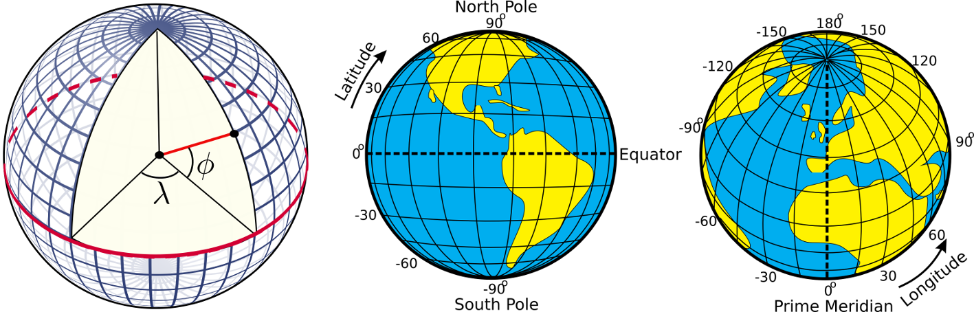
The latitudes are circles parallel to the equator. They are counted from at the equator to at the poles. The longitudes are great circles connecting the two poles of the Earth. For a given position on Earth, the longitude going through the zenith, the point directly above, is called the meridian. This is the line the Sun apparently crosses at local noon. The origin of this coordinate is defined as the Prime Meridian, and passes Greenwich, where the Royal Observatory of England is located. From there, longitudes are counted from to .
Example: Heidelberg in Germany is located at 494 North and 87 East.
1.3 Elevation if the pole (pole height)
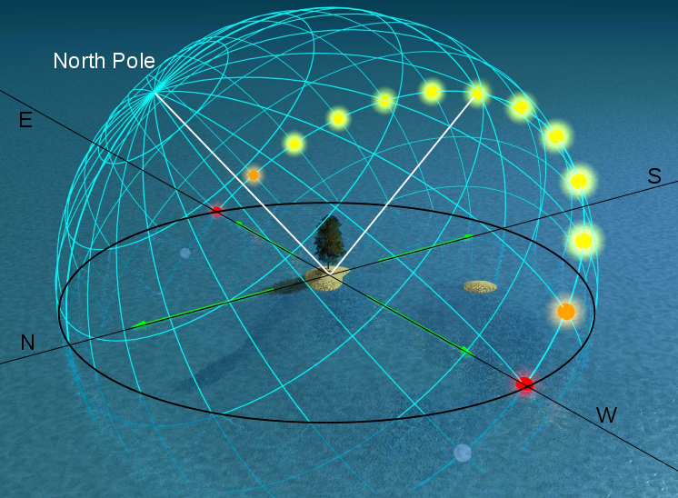
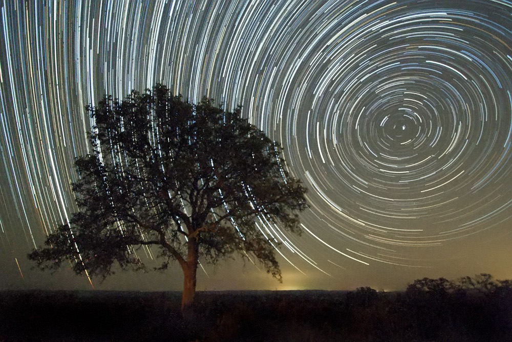
If we project the terrestrial coordinate system of latitudes and longitudes at the sky, we get the celestial equatorial coordinate system. The Earth’s equator becomes the celestial equator and the geographic poles are extrapolated to build the celestial poles. If we were to make a photograph with a long exposure of the northern sky, we would see from the trails of the stars that they all revolve about a common point, the northern celestial pole (Fig. 3).
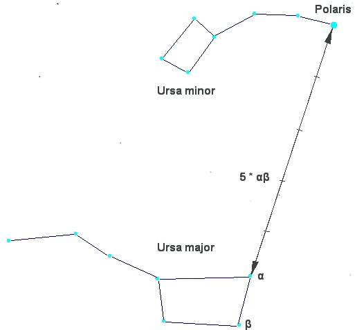
In the northern hemisphere, there is a moderately bright star near the celestial pole, the North Star or Polaris. It is the brightest star in the constellation the Little Bear, Ursa Minor (Fig. 4). In our era, Polaris is less than a degree off. However, 1000 years ago, it was away from the pole. Therefore, today we can use it as a proxy for the position of the celestial North Pole. At the southern celestial pole, there is no such star that can be observed with the naked eye. Other procedures have to be applied to find it.
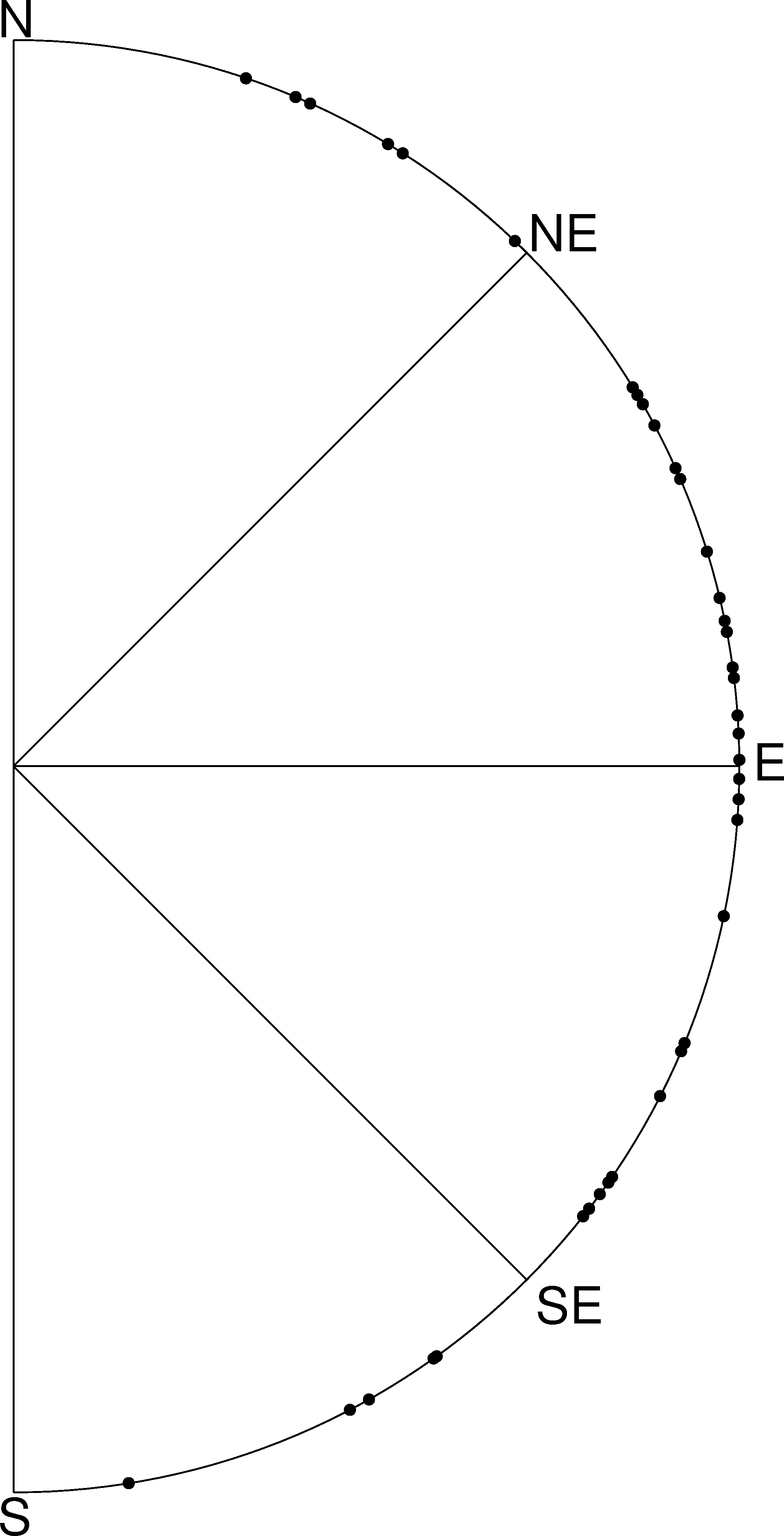
If we stood exactly at the geographic North Pole, Polaris would always be directly overhead. We can say that its elevation would be (almost) . This information already introduces the horizontal coordinate system (Fig. 5). It is the natural reference we use every day. We, the observers, are the origin of that coordinate system located on a flat plane whose edge is the horizon. The sky is imagined as a hemisphere above. The angle between an object in the sky and the horizon is the altitude or elevation. The direction within the plane is given as an angle between and , the azimuth, which is usually counted clockwise from north. In navigation, this is also called the bearing. The meridian is the line that connects North and South at the horizon and passes the zenith.
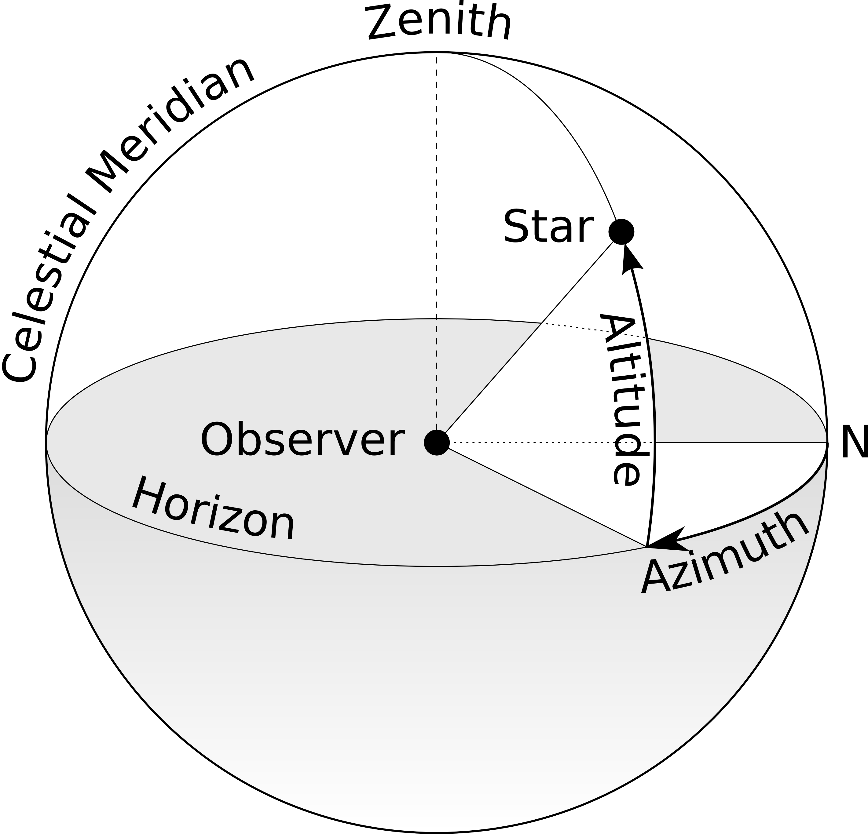
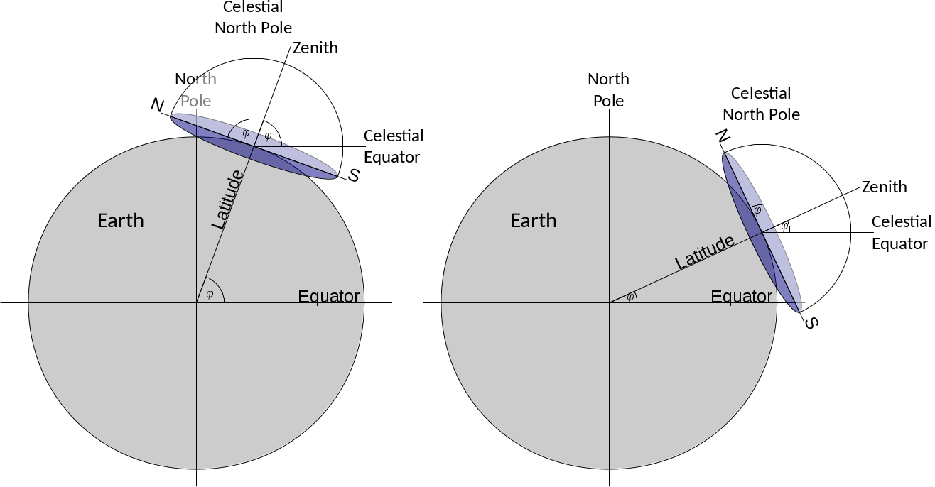
For any other position on Earth, the celestial pole or Polaris would appear at an elevation smaller than . At the equator, it would just graze the horizon, i.e. be at an elevation of . The correlation between the latitude (North Pole = , Equator = ) and the elevation of Polaris is no coincidence. Figure 6 combines all three mentioned coordinate systems. For a given observer at any latitude on Earth, the local horizontal coordinate system touches the terrestrial spherical polar coordinate system at a single tangent point. The sketch demonstrates that the elevation of the celestial North Pole, also called the pole height, is exactly the northern latitude of the observer on Earth. From this we can conclude that if we measure the elevation of Polaris, we can determine our latitude on Earth with reasonable precision.
1.4 Circumpolar stars and constellations
In ancient history, e.g. during the Bronze Age, Polaris could not be used to determine north. Due to the precession of the Earth’s axis, it was about away from the celestial North Pole in 3,500 BCE. Instead, the star Thuban ( Draconis) was more appropriate, as it was less than off. However, it was considerably fainter than Polaris and perhaps not always visible to the naked eye.
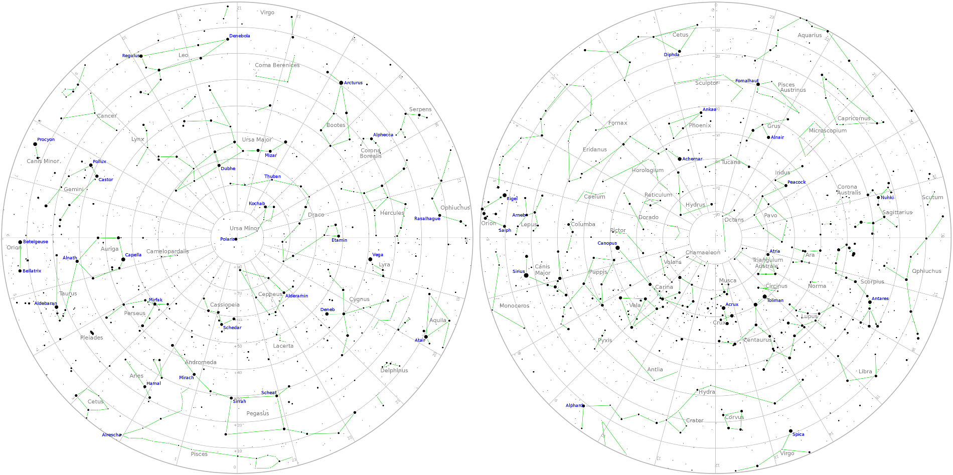
When looking at the night sky, some stars within a certain radius around the celestial poles never set; they are circumpolar (see Fig. 3). Navigators were skilled enough to determine the true position of the celestial pole, by observing a few stars close to it. This method also works for the southern celestial pole. There are two videos that demonstrate the phenomenon.
CircumpolarStars Heidelberg 49degN (Duration: 0:57)
https://youtu.be/uzeey9VPA48
CircumpolarStars Habana 23degN (Duration: 0:49)
https://youtu.be/zggfQC_d7UQ
They show the movement of the night sky when looking north for two different latitudes coinciding with the cities of Heidelberg, Germany ( North) and Lisbon, Portugal ( North). The videos illustrate that
-
1.
there are always stars and constellations that never set. Those are the circumpolar stars and constellations.
-
2.
the angle between the celestial pole (Polaris) and the horizon depends on the latitude of the observer. In fact, these angles are identical.
-
3.
the circumpolar region depends on the latitude of the observer. It is bigger for locations closer to the pole.
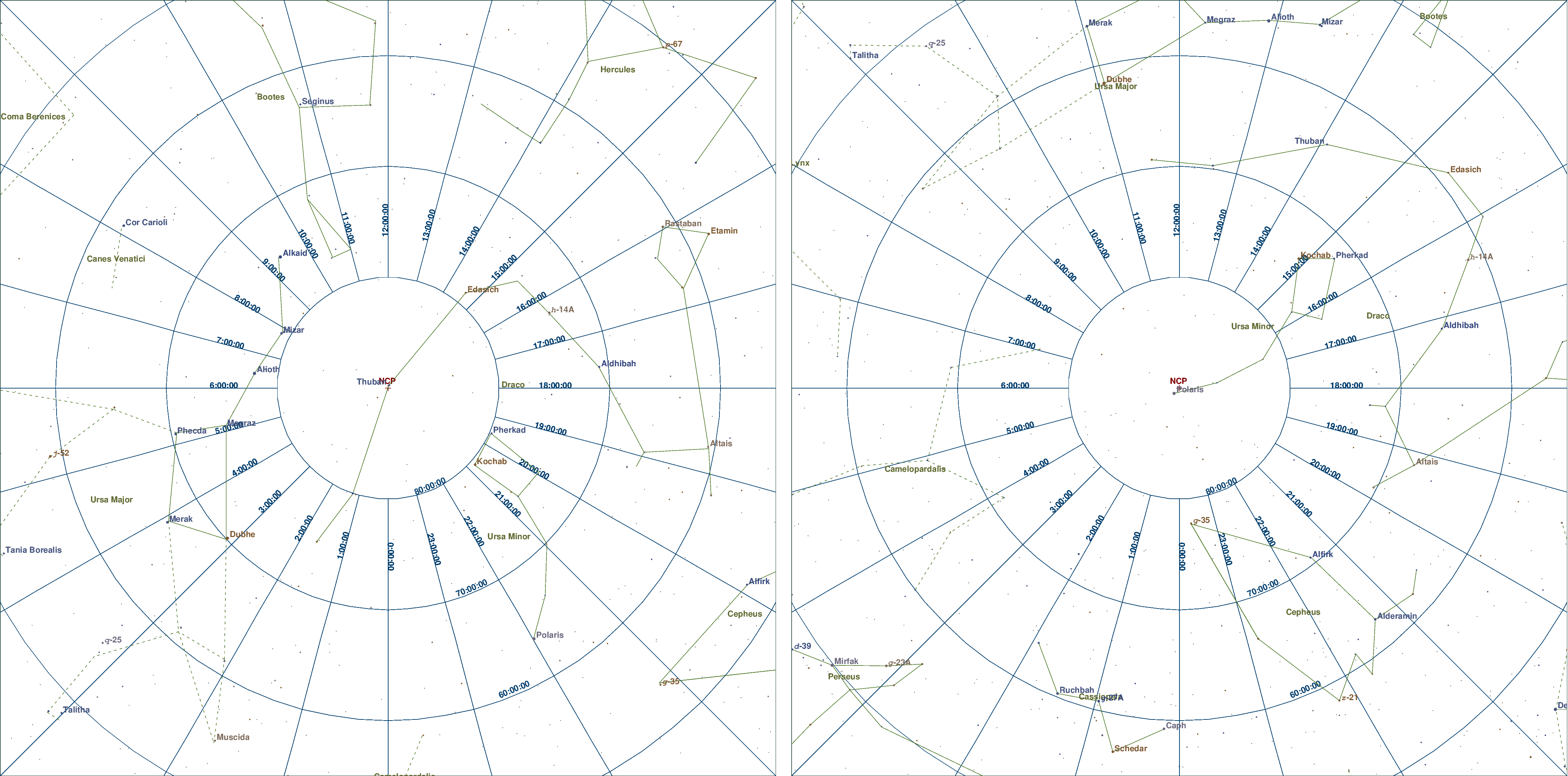
If the students are familiar with the usage of a planisphere, they can study the same phenomenon by watching the following two videos. They show the rotation of the sky for the latitudes and . The transparent area reveals the visible sky for a given point in time. The dashed circle indicates the region of circumpolar stars and constellations.
CircumPolarStars phi N20 (Duration: 0:37)
https://youtu.be/Uv-xcdqhV00
CircumPolarStars phi N45 (Duration: 0:37)
https://youtu.be/VZ6RmdzbpPw
When sailing north or south, sailors observe that with changing elevation of the celestial pole the circumpolar range is altered, too. Therefore, whenever navigators see the same star or constellation culminating – i.e. passing the meridian – at the same elevation, they stay on the “latitude”. Although the educated among the ancient Greek were familiar with the concept of latitude of a spherical Earth, common sailors were probably not. For them, it was sufficient to realise the connection between the elevation of stars and their course. Ancient navigators knew the night sky very well. In particular, they utilised the relative positions of constellation which helped them to determine their position in terms of latitude.
1.5 Early seafaring and navigation in the Mediterranean
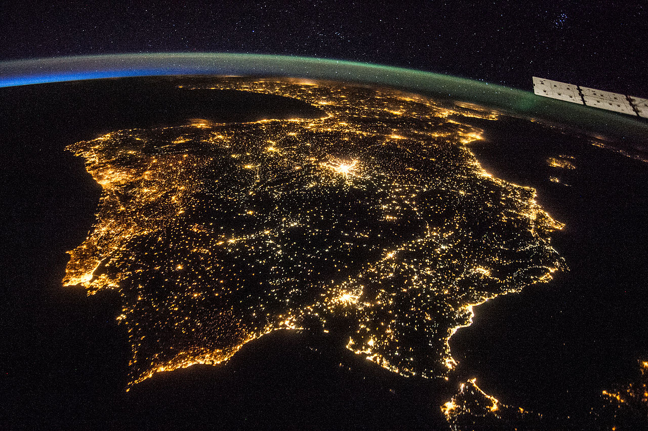
Navigation using celestial objects is a skill that emerged already long before humans roamed the Earth. Today, we know numerous examples among animals who find their course using the day or night sky. Bees and monarch butterflies navigate by the Sun (Sauman et al. 2005), just like starlings do (Kramer 1952). Even more impressive is the ability of birds (Emlen 1970; Lockley 1967; Sauer 1958) and seals (Mauck et al. 2008) to identify the position of stars during night-time for steering a course. However, in our modern civilisation with intense illumination of cities, strong lights can be mistaken for celestial objects. For instance, moths use the moon to maintain a constant course, but if confused by a street lamp, they keep on circling around it until exhaustion (Stevenson 2008). Hence, light pollution is a serious threat to many animals. Its magnitude is demonstrated by Fig. 8.
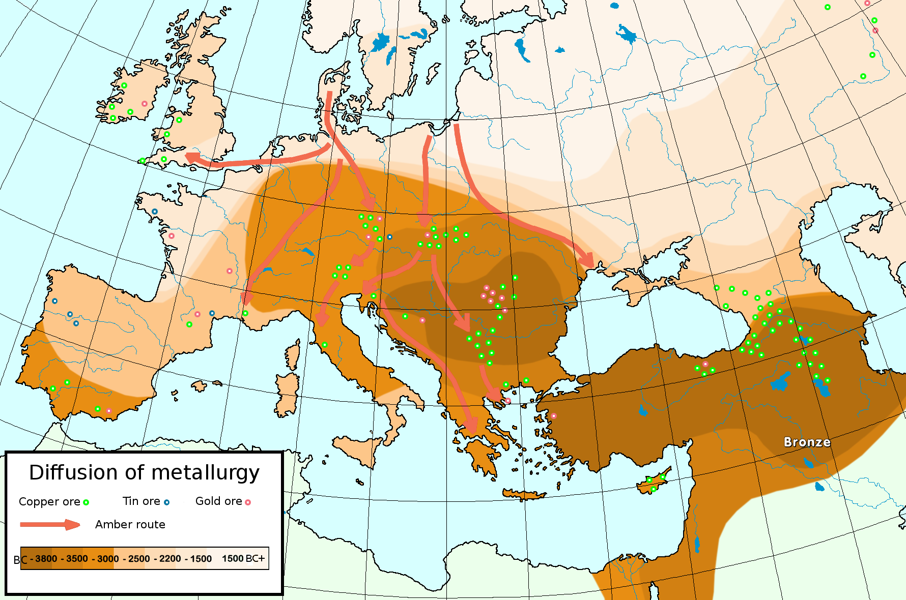
Among the first humans to have navigated the open sea were the aboriginal settlers of Australia some 50,000 years ago (Hiscock 2013). The oldest records of seafaring in the Mediterranean date back to 7,000 BCE (Hertel 1990), admittedly done with boats or small ships that were propelled by paddles only. The routes were restricted close the coast where landmarks helped to navigate to the desired destinations. In order to be able to cross larger distances, propulsion independent of muscle force is needed. Therefore, the sail was one of the most important inventions in human history, in its significance similar to the wheel. Around the middle of the 4th millennium BCE, Egyptian ships sailed the eastern Mediterranean (Bohn 2011) and established trade routes with Byblos in Phoenicia, the biblical Canaan, now Lebanon. This is about the time when the Bronze Age began. Tin is an important ingredient to bronze. After the depletion of the local deposits, tin sources in central and western Europe triggered large scale trade (Penhallurick 1986). Transportation over large distances inside and outside the Mediterranean was accomplished by ships.
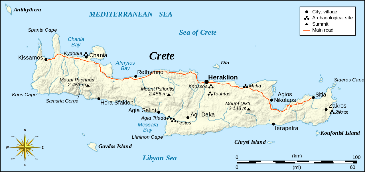
Soon, the navigators realised that celestial objects, especially stars, can be used to keep the course of a ship. Such skills have been mentioned in early literature like Homer’s Odyssey which is believed to date back to the 8th century BCE. The original sources are thought to originate from the Bronze Age, in which the Minoans of Crete were a particularly influential people that lived between 3,650 and 1,450 BCE in the northern Mediterranean, and who sailed the Aegean Sea. Since many of their sacral buildings were aligned with the cardinal directions and astronomical phenomena like the rising Sun and the equinoxes (Henriksson & Blomberg 2008, 2009), it is reasonable to think that they used this knowledge for navigation, too (Blomberg & Henriksson 1999). The Minoans sailed to the island of Thera and Egypt, which would have taken them on open water for several days.
The Greek poet Aratos of Soli published his Phainomena around 275 BCE (Aratus et al. 1921) in which he provided detailed positions of constellations and their order of rising and setting, which would be vital information for any navigator to maintain a given course. He would simply have pointed his ship at a bearing and be able to keep it with the help of stellar constellations that appeared towards that heading. The azimuth of a given star when rising or setting remains constant throughout the year, except for a slow variation caused by the 26,000 years period of the precession of the Earth’s axis. Interestingly, Aratos’ positions did not fit the Late Bronze and Early Iron Age but the era of the Minoan reign (Blomberg & Henriksson 1999) some 2,000 years earlier.
Around 1200 BCE, the Phoenicians became the dominating civilisation in the Mediterranean. They built colonies along the southern and western coasts of the Mediterranean and beyond. Among them was the colony of Gades (now Cadíz) just outside the Strait of Gibraltar which served as a trading point for goods and resources from Northern Europe (Cunliffe 2003; Hertel 1990). Several documented voyages through the Atlantic Ocean took them to Britain and even several hundred miles south along the African coast (Johnson & Nurminen 2009).
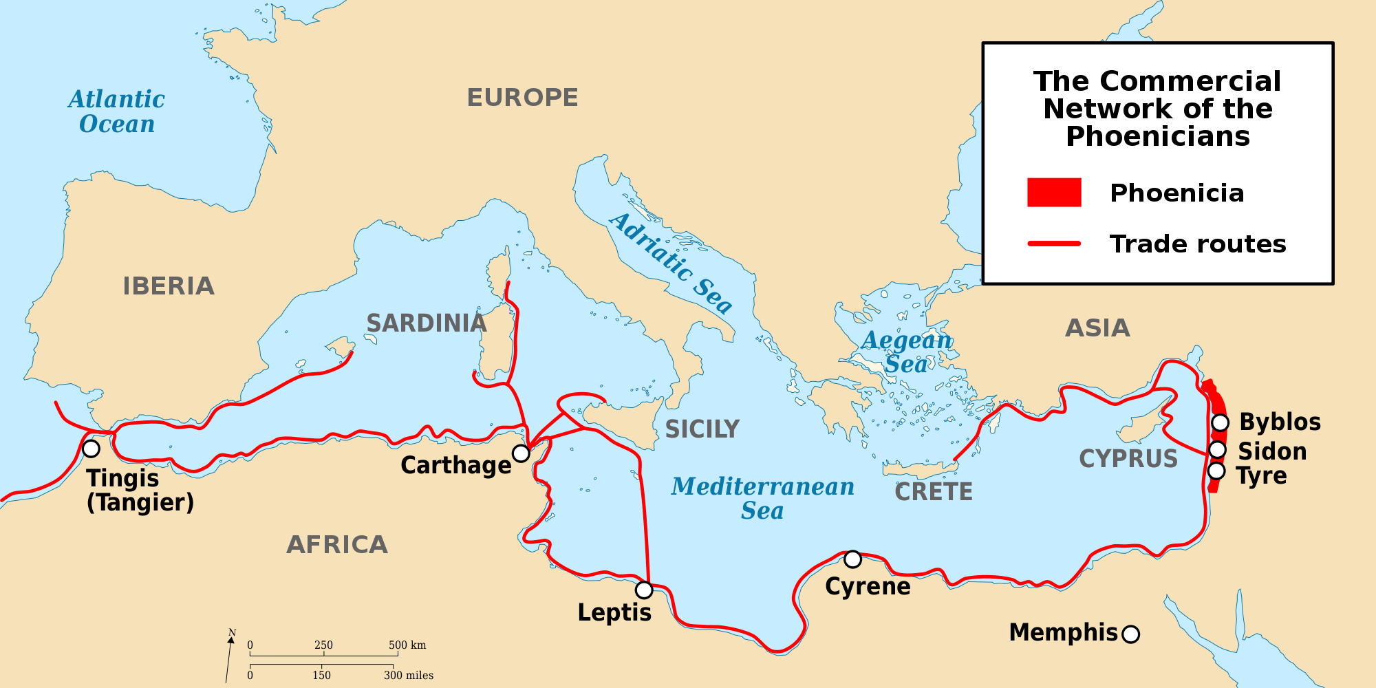
The Greek historian Herodotus (ca. 484 – 420 BCE) reports of a Phoenician expedition funded by the Egyptian Pharaoh Necho II (610 -– 595 BCE) that set out from the Red Sea to circumnavigate Africa and returned to Egypt via the Mediterranean (Bohn 2011; Hertel 1990; Johnson & Nurminen 2009). The sailors apparently reported that at times the Sun was located North (Cunliffe 2003) which is expected after crossing the equator to the south. All this speaks in favour of extraordinary navigational skills. After the Persians conquered the Phoenician homeland in 539 BCE, their influence declined, but was re-established by descendants of their colonies, the Carthaginians.
1.6 Pytheas
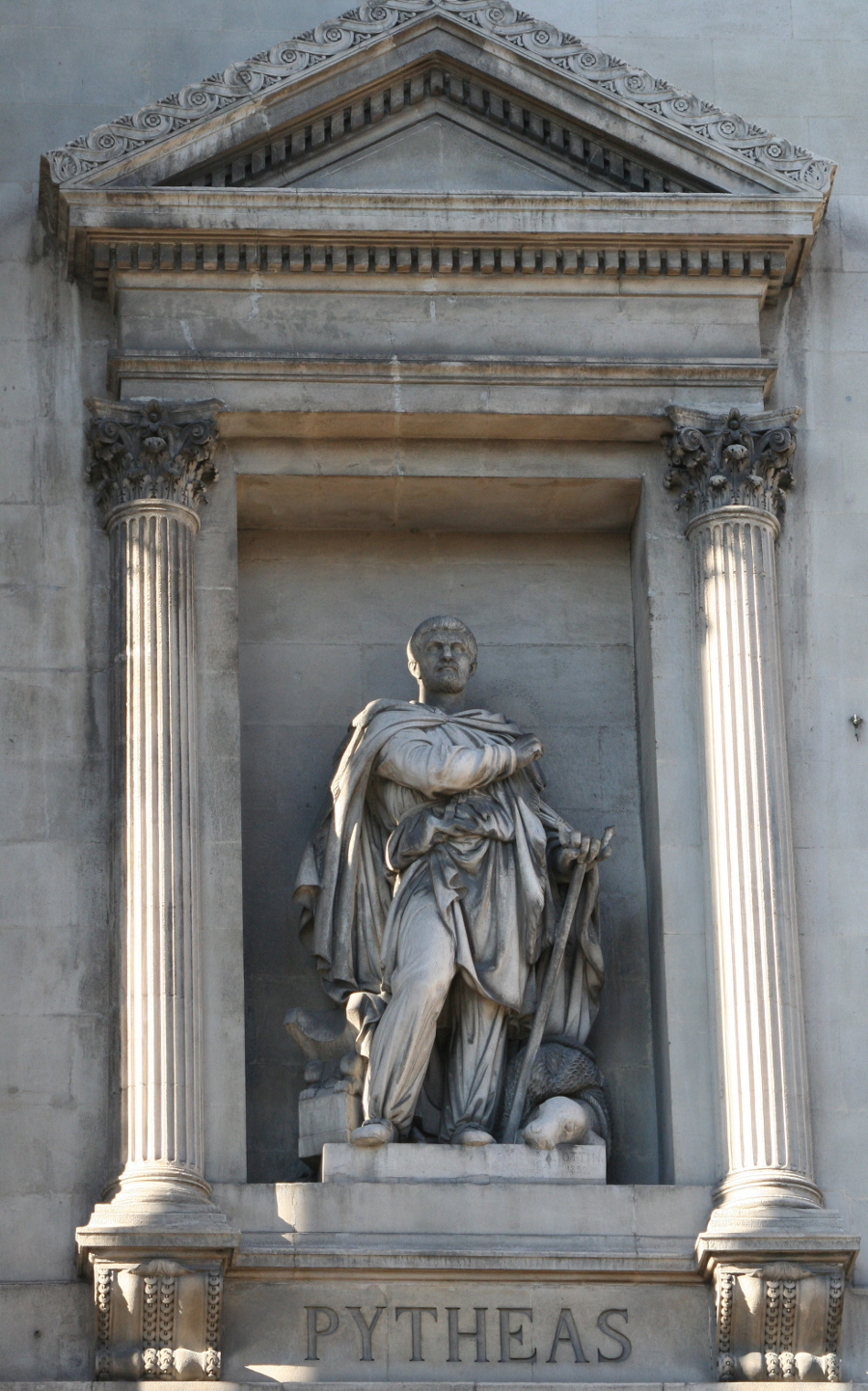
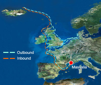
A very notable and well documented long distance voyage has been passed on by ancient authors and scholars like Strabo, Pliny and Diodorus of Sicily. It is the voyage of Pytheas (ca. 380 – 310 BCE), a Greek astronomer, geographer and explorer from Marseille who around 320 BCE apparently left the Mediterranean, travelled along the European west coast and made it up north until the British Isles and beyond the Arctic Circle, during which he possibly reached Iceland or the Faroe Islands that he called Thule (Baker & Baker 1997; Cunliffe 2003; Hergt 1893).
Massalia (or Massilia), as it was called then, was founded by Phocean Greeks around 600 BCE, and quickly evolved into one of the biggest and wealthiest Greek outposts in the Western Mediterranean with strong trade relations to Celtic tribes who occupied most of Europe (Cunliffe 2003). Pytheas was born into the Late Bronze Age, when the trade with resources from Northern Europe was flourishing. Not much was known in Greek geography about this part of the world, except that the barbarians living there mined the tin ore and delivered the precious amber that the whole Mediterranean so desperately longed for. Perhaps it was out of pure curiosity why Pytheas set out to explore these shores.
His voyage was a milestone, because Pytheas was a scientist and a great observer. He already used a gnomon or a sundial, which allowed him to determine his latitude and measure the time during his voyage (Nansen 1911). He also noticed that in summer the Sun shines longer at higher latitudes. In addition, he was the first to notice a relation between the tides, which are practically not present in the Mediterranean, and the lunar phases (Roller 2006).
2 List of material
The list contains items needed by one student. The teacher may decide that they work in groups of two.
-
•
Worksheet
-
•
Pair of compasses
-
•
Pencil
-
•
Ruler
-
•
Calculator
-
•
Protractor
-
•
Torch (for supplemental third activity)
-
•
Magnetic compass (optional, third activity)
-
•
Computer with MS Excel installed
-
•
Excel spreadsheet:
astroedu1645_AncientMediterranean_BrightStars.xlsx
3 Goals
With this activity, the students will learn that
-
•
celestial navigation has been developed already many centuries ago.
-
•
apart from using Polaris there are other methods to determine cardinal directions from the positions of stars.
-
•
ancient navigators were able to successfully navigate on open water following stars and constellations.
4 Learning objectives
The students will be able to
-
•
describe methods to determine the cardinal directions form observing the sky.
-
•
name prominent stellar constellations.
-
•
explain the nature of circumpolar stars and constellations.
-
•
use an Excel spreadsheet for calculations.
-
•
describe the importance of improved navigational skills for early civilisations.
5 Target group details
Suggested age range: 14 – 19 years
Suggested school level: Middle School, Secondary School
Duration: 90 minutes
6 Evaluation
According to the suggested questions listed in the description of the activity, the teacher should guide the students to recognise the positions and the apparent movement of celestial objects as indicators for cardinal directions.
Before working on activity 1, the students should look closely at the map provided. A visit at a planetarium helps remembering the constellations. Let the students name constellations they already know.
Ask the students (see Q&A in the activity description) where the North Star would be when observed from the terrestrial North Pole and the Equator. Then ask them, how this position changes when travelling between these locations. When that concept is understood, introduce the rotation and the apparent motion of the stars. Show them the picture of the star trails and ask them, where they come from. Ask them, which of the stars or constellations remain above the horizon for the different locations on Earth mentioned above. Those are circumpolar stars and constellations.
Explain the usage of the Excel spreadsheet needed for activity 2. Let the students compare their results for different latitudes.
Discuss with the students, what the reasons for seafaring could have been in ancient epochs.
The third optional activity acts as a wrap-up and can be used to evaluate, what the students have understood.
7 Full description of the activity
7.1 Introduction
It would be beneficial, if the activity be included into a larger context of seafaring, e.g. in geography, history, literature, etc.
Tip: This activity could be combined with other forms of acquiring knowledge like giving oral presentations in history, literature or geography highlighting navigation. This would prepare the field in a much more interactive way than what a teacher can achieve by summarising the facts.
There are certainly good documentaries available on sea exploration that could be shown. As an introduction to celestial navigation in general and the early navigators, let the students watch the following videos. The last one is in French. This could be done in junction with French lessons in school. If not, tell the story about Pytheas as outlined in the background information. A link to literature or history classes may be established by reading “The Extraordinary Voyage of Pytheas” by B. Cunliffe.
Episode 2: Celestial Navigation (Duration: 4:39)
https://www.youtube.com/watch?v=DoOuSo9qElI
How did early Sailors navigate the Oceans? — The Curious Engineer (Duration: 6:20)
https://www.youtube.com/watch?v=4DlNhbkPiYY
World Explorers in 10 Minutes (Duration: 9:59)
https://www.youtube.com/watch?v=iUkOfzhvMMs
Once upon a time … man: The Explorers - The first navigators (Duration: 23:13)
https://www.youtube.com/watch?v=KuryXLnHsEY
Pythéas, un Massaliote méconnu (French, duration: 9:57)
https://www.youtube.com/watch?v=knBNHbbu-ao
Ask the students, if they had an idea for how long mankind already uses ships to cross oceans. One may point out the spread of the Homo sapiens to islands and isolated continents like Australia.
Possible answers:
We know for sure that ships have been used to cross large distances already
since 3,000 BCE or earlier. However, the early settlers of Australia must have
found a way to cross the Oceans around 50,000 BCE.
Ask them, what could have been the benefit to try to explore the seas. Perhaps, someone knows historic cultures or peoples that were famous sailors. The teacher can support this with a few examples of ancient seafaring peoples, e.g. from the Mediterranean.
Possible answers:
Finding new resources and food, trade, spirit of exploration, curiosity.
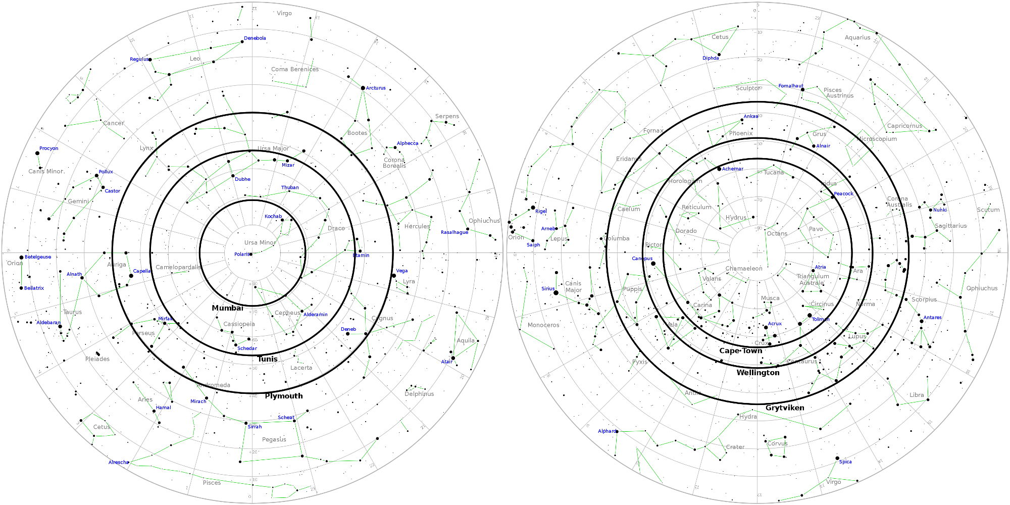
| City | Latitude () | Radius in map (cm) | Constellations |
|---|---|---|---|
| Tunis (ancient | 36.8 | 3.7 | Ursa Minor, Ursa Major (Big Dipper), Draco, Cepheus, Cassiopeia |
| Carthage, Tunisia) | |||
| Cape Town | -33.9 | 3.4 | Crux, Pavo (Peacock), Achernar, most of Carina, Toliman |
| (South Africa) | of Centaurus | ||
| Plymouth | 50.4 | 5.0 | Ursa Minor, Ursa Major, Draco, Cepheus, Cassiopeia, Perseus |
| (UK) | (mostly), part of Cygnus with Deneb | ||
| Wellington | -41.3 | 4.1 | Carina (incl. Canopus), Ara, Pictor, Dorado |
| (New Zealand) | |||
| Mumbai | 19.0 | 1.9 | Ursa Minor |
| (India) | |||
| Grytviken | -54.3 | 5.4 | Centaurus, Lupus, Main part of Puppis, Phoenix, Grus |
| (South Georgia) |
Ask the students, how they find the way to school every day. What supports their orientation to not get lost? As soon as reference points (buildings, traffic lights, bus stops, etc.) have been mentioned ask the students how navigators were able to find their way on the seas. In early times, they used sailing directions in connection to landmarks that can be recognised. But for this, the ships would have to stay close to the coast. Lighthouses improved the situation. Magnetic compasses have been a rather late invention around the 11th century CE, and they were not used in Europe before the 13th century. But what could be used as reference points at open sea? Probably the students will soon mention celestial objects like the Sun, the Moon and stars.
Suggested additional questions, especially after showing the introductory videos:
Q: Who was Pytheas?
A: He was an ancient Greek scientist and explorer.
Q: Where and when did he live?
A: He lived in the 4th century BCE during the Late Bronze Age in Massalia, now
Marseille.
Q: Where did he travel?
A: Pytheas travelled north along the Atlantic coast of Europe to Britain and
probably to the Arctic Circle and Iceland.
Q: What did he observe and discover during his voyage?
A: He was the first Greek to travel so far to the north. He noticed that the
length of daylight depends on latitude. He was also the first to relate the
tides to the phases of the moon.
7.2 Activity 1: Circumpolar constellations and stars
In absence of a bright star at the celestial poles, ancient navigators were able to find it by observing a few circumpolar stars. These navigators were experienced enough to determine true north by recognising the relative position of such stars and by their paths around it.
In addition, they used circumpolar constellations and stars to infer their latitude. This means, they never rise or set – they are always above the horizon. While today we can simply measure the elevation of Polaris above the horizon, ancient navigators saw that star many degrees away from the celestial North Pole. In the southern hemisphere, there is no such stellar indicator anyway. So, instead of measuring the elevation of Polaris, they observed which stars and constellations were still visible above the horizon when they attained their lowest elevation above the horizon (lower culmination) during their apparent orbit around the celestial pole.
Let the students watch the two following videos that demonstrate the phenomenon of circumpolar stars and constellations for two locations on Earth. They show the simulated daily apparent rotation of the sky around the northern celestial pole.
CircumpolarStars Heidelberg 49degN (Duration: 0:57)
https://youtu.be/uzeey9VPA48
CircumpolarStars Habana 23degN (Duration: 0:49)
https://youtu.be/zggfQC_d7UQ
The students will notice that
-
1.
there are always stars and constellations that never set. Those are the circumpolar stars and constellations.
-
2.
the angle between the celestial pole (Polaris) and the horizon depends on the latitude of the observer. In fact, these angles are identical.
-
3.
the circumpolar region depends on the latitude of the observer. It is bigger for locations closer to the pole.
If the students are familiar with the usage of a planisphere, they can study the same phenomenon by watching the following two videos.
CircumPolarStars phi N20 (Duration: 0:37)
https://youtu.be/Uv-xcdqhV00
CircumPolarStars phi N45 (Duration: 0:37)
https://youtu.be/VZ6RmdzbpPw
They show the rotation of the sky for the latitudes and . The transparent area reveals the visible sky for a given point in time. The dashed circle indicates the region of circumpolar stars and constellations.
7.2.1 Questions
Q: What is special about the geographic North and South Poles of the Earth
compared to other locations?
A: They define the rotation axis of the Earth.
Q: How do you find North and the other cardinal directions without a compass? A: Celestial bodies, e.g. stars like Polaris which indicates the celestial north pole.
Q: Why does the North Star (Polaris) indicate North?
A: In our lifetime, Polaris is close to the celestial north pole.
Q: Where in the sky would be the celestial North/South Pole if you stood exactly
at the terrestrial North/South Pole?
A: At the zenith, i.e. directly overhead.
Q: How would this position change, if you travelled towards the equator?
A: Its elevation would decline from zenith to the horizon.
Q: What are circumpolar constellations?
A: These are constellations that revolve around one of the celestial poles and
never rise or set. They are always above the horizon.
Q: Which of the visible constellations would be circumpolar, if you stood on the
terrestrial North/South Pole/equator?
A: The entire northern/southern hemisphere (poles). None at the equator.
Q: If the North Star was not visible, how would you be able to determine you latitude anyway?
A: Since the circumpolar stars and constellations depend on the latitude, just
like the elevation of Polaris, the ones that always stay above the horizon
indicate, where I am.
7.2.2 Exercise
The task is now to walk in the footsteps of a navigator that lived around 5,000 years ago. Based on those skills, the students will determine the constellations that are circumpolar when observed from given positions on Earth.
The table below contains the names of six cities along with their latitudes . Negative values indicate southern latitudes. A seventh row is empty, where the students can add the details of their home town. From this, they will have to calculate the angular radii from the celestial pole. The calculation is simple, because is the same as the pole height and the latitude:
Then they select the map that matches the hemisphere. The students use the compasses to draw circles of those radii around the corresponding pole. The constellations inside that circle are circumpolar. The constellations that are just fully or partially visible for a given city are added to the table.
Possible solutions are added in italics. The table prepared for the exercise is contained in the worksheet.
7.2.3 Detailed instructions
-
1.
Determine the map scale. The angular scale is from the poles to the outer circle, i.e. the celestial equator.
-
2.
Convert the latitudes in the table into radii in the scale of the maps and add them to the table.
-
3.
For each of the cities:
-
(a)
Select the suitable map.
-
(b)
Use the compasses to draw a circle with a radius that was determined for that city.
-
(c)
Find and note the visible circumpolar constellations. If they are too many, just select the most prominent ones.
-
(a)
7.2.4 Discussion
In ancient times, Polaris did not coincide with the celestial North Pole. Explain the importance of circumpolar stars and constellations for ancient navigators.
Possible result:
They provided an excellent tool to maintain latitude and helped to not get lost
at open sea.
7.2.5 Solutions
The map scale is:
7.3 Activity 2: Stars guide the way
In the absence of a star like Polaris that indicates a celestial pole, ancient navigators used other stars and constellations to determine cardinal directions and their ship’s course. They realised that the positions where they appear and disappear at the horizon (the bearings) do not change during a lifetime. Experienced navigators knew the brightest stars and constellations by heart.
7.3.1 Questions
Q: Can you determine the cardinal directions from other stars than Polaris? Note that there is no star at the South Pole.
A: Yes. If you know the stars and constellations, they can guide the way, as they return to the same positions each day.
Q: Why can you use rising and setting stars and constellations to steer a course on sea?
A: The position at the horizon when rising and setting does not change (except for a very slow long term variation).
Q: Would you be able to see the same stars every night during the year?
A: No, the time of rise and set changes. Stars visible during winter nights are up during summer daytimes.
7.3.2 Exercise
The students will produce a stellar compass similar to Fig. 17. The calculations that are needed to convert the sky coordinates of the stars into horizontal coordinates, i.e. azimuth and elevation, are pretty complex. Therefore, this activity comes with an Excel file that does it for them. It consists of 57 bright stars plus the Pleiades which is a very prominent group of stars.
All they have to do is entering the latitude of their location and the elevation of the stars in the corresponding line at the bottom of the spreadsheet. For the elevation, is a good value. This means, they will get the azimuths of the stars when observed at an elevation of . One can also use different values, but this exercise is meant for finding stars that just rise or set. The azimuth is an angle along the horizon, counting clockwise from North.
The last two columns (AZ1, AZ2) then display two azimuths, one when the star is rising and one when the star is setting. Note that the distribution of azimuths for rising and setting stars is symmetric relative to the meridian, i.e. the line that connects North and South. The cells that show #NA do not contain valid numbers. These stars never rise or set. They are either circumpolar or below the horizon.
The students translate the values into the stellar compass below. They use a protractor and indicate the position of each star on the circle. Then they write its name next to it.
7.3.3 Discussion
One of the methods to navigate through the ancient Mediterranean was to stay close to the shores. Besides the danger of shallow waters, explain why Bronze Age mariners must have had methods that would have allowed them to safely navigate on open waters. You may want to look at a map of the Mediterranean.
Possible answers: The ancient peoples also visited islands for trade or other reasons. Many of them are not visible from coastlines of the Mediterranean. The voyages often would also last longer than just a few hours. Vessels of that age were able to pass five nautical miles per hour on average. There are also reports that were passed on through the ages which tell us about celestial navigation.
7.4 Activity 3: Do it yourself! (Supplemental)
Nothing is more instructive than actually applying to real conditions what has been learned and exercised in theory. Therefore, the results from the previous two activities can be tested in the field by observing the night sky.
This activity can be done by the students themselves at home or as a group event with the class.
Select a clear evening and a site with a good view to the horizon. As soon as it is dark enough to see the stars, let the students use their dimmed torches to inspect their maps with the circumpolar ranges from activity 1. A dimmed torch - even better: a red one – helps to keep the eyes adapted to the dark.
After identifying the brightest stars, let them use their stellar compasses from activity 2. The students should point the markers of one or some of the stars to the stars at the sky. Let them identify North (or South, depending on which celestial pole is visible from your location). If in the northern hemisphere, does this match the direction to the North Star, Polaris? In the southern hemisphere, a magnetic compass might be needed.
Let the students identify the constellations they see in the sky on their maps. Ask them to look North (South in the southern hemisphere) and name the stars and constellations that are just above the horizon. Does this coincide with the maps? Note that there should be a circle that indicates the circumpolar range for the local latitude.
Try to highlight that by doing this activity, they are working like the navigators from 4,000 years ago.
8 Connection to school curriculum
This activity is part of the Space Awareness category “Navigation Through The Ages” and related to the curricula topics:
-
•
Coordinate systems
-
•
Basic concepts, latitude, longitude
-
•
Celestial navigation
-
•
Constellations
-
•
Instruments
9 Conclusion
The students learn about navigational methods and seafaring of the ancient epochs like the Bronze Age. Within two activities (plus one optional supplemental activity), they will learn how the apparent diurnal paths of stars can help to find the cardinal directions and to set course to known destinations in the Mediterranean.
Acknowledgements.
This resource was developed in the framework of Space Awareness. Space Awareness is funded by the European Commission’s Horizon 2020 Programme under grant agreement no. 638653.References
- Aratus et al. (1921) Aratus, Callimachus, & Lycophron. 1921, Callimachus: Hymns and Epigrams, Lycophron and Aratus, 2nd edn., Loeb Classical Library No. 129 (Harvard University Press), http://www.theoi.com/Text/AratusPhaenomena.html
- Baker & Baker (1997) Baker, R. F. & Baker, C. F. 1997, Ancient Greeks: Creating the Classical Tradition (New York, USA: Oxford University Press)
- Blomberg & Henriksson (1999) Blomberg, M. & Henriksson, G. 1999, in Światowit. Supplement series H, Vol. 2, Actes de la Vème Conférence annuelle de la SEAC, ed. A. Le Beuf & M. Ziolkowski (Warszawa, Poland: Société européenne pour l’astronomie dans la culture Conférence anuelle), 69–81, http://minoanastronomy.mikrob.com/pdf/1999%20Gdansk.pdf
- Bohn (2011) Bohn, R. 2011, Geschichte der Seefahrt, C. H. Beck Wissen No. 2722 (München: Verlag C. H. Beck oHG)
- Cunliffe (2003) Cunliffe, B. 2003, The Extraordinary Voyage of Pytheas the Greek, paperback edn. (Harmondsworth, UK: Penguin Books)
- Emlen (1970) Emlen, S. T. 1970, Science, 170, 1198, http://science.sciencemag.org/content/170/3963/1198.full.html
- Henriksson & Blomberg (2008) Henriksson, G. & Blomberg, M. 2008, Archaeologica Baltica, 10, 125, http://briai.ku.lt/downloads/AB/10/10_125-130_Henriksson,_Blomberg.pdf
- Henriksson & Blomberg (2009) Henriksson, G. & Blomberg, M. 2009, in ASP Conference Series, ed. J. A. Rubiño-Martín, J. A. Belmonte, F. Prada, & A. Alberdi, Vol. 409 (San Francisco, USA: Astronomical Society of the Pacific), 430–435, http://minoanastronomy.mikrob.com/pdf/2009%20Granada.pdf
- Hergt (1893) Hergt, W. G. 1893, Die Nordlandfahrt des Pytheas (Halle an der Saale, Germany: Hofbuchdruckerei von C. A. Kaemmerer & Co.)
- Hertel (1990) Hertel, P. 1990, Das Geheimnis der alten Seefahrer, Geographische Bausteine No. 38 (Gotha, Germany: Hermann Haack Verlagsgesellschaft mbH)
- Hiscock (2013) Hiscock, P. 2013, in Paleoamerican Odyssey, ed. K. E. Graf, C. V. Ketron, & M. R. Waters (College Station, USA: Center for the Study of the First Americans, Department of Anthropology, Texas A & M University), 3–11, https://www.researchgate.net/publication/283609921_Occupying_new_lands_Global_migrations_and_cultural_diversification_with_particular_reference_to_Australia
- Johnson & Nurminen (2009) Johnson, D. S. & Nurminen, J. 2009, The History of Seafaring, 2nd edn. (National Geographic), authorised German Edition
- Kramer (1952) Kramer, G. 1952, Ibis, 94, 265, http://onlinelibrary.wiley.com/doi/10.1111/j.1474-919X.1952.tb01817.x/abstract
- Lane (1963) Lane, F. C. 1963, The American Historical Review, 68, 605, http://www.jstor.org/stable/1847032
- Lockley (1967) Lockley, R. M. 1967, Animal Navigation (New York, USA: Hart Publishing Company, Inc.)
- Mauck et al. (2008) Mauck, B., Gläser, N., Schlosser, W., & Dehnhardt, G. 2008, Animal Cognition, 11, 715, https://www.ncbi.nlm.nih.gov/pubmed/18465153
- Nansen (1911) Nansen, F. 1911, In Northern Mists: Arctic Exploration in Early Times, Vol. 1 (New York: Frederick A. Stokes company)
- Penhallurick (1986) Penhallurick, R. D. 1986, Tin in antiquity: its mining and trade throughout the ancient world with particular reference to Cornwall (London, UK: Institute of Metals)
- Roller (2006) Roller, D. W. 2006, Through the Pillars of Herakles: Greco-Roman Exploration of the Atlantic (New York, USA: Routledge (Taylor & Francis))
- Sauer (1958) Sauer, E. G. F. 1958, Scientific American, 199, 42, http://www.nature.com/scientificamerican/journal/v199/n2/pdf/scientificamerican0858-42.pdf
- Sauman et al. (2005) Sauman, I., Briscoe, A. D., Zhu, H., et al. 2005, Neuron, 46, 457, http://dx.doi.org/10.1016/j.neuron.2005.03.014
- Stevenson (2008) Stevenson, A. 2008, Probing Question: Why are moths attracted to light?, Penn State News, http://news.psu.edu/story/141283/2008/10/20/research/probing-question-why-are-moths-attracted-light
Glossary
Appendix A Supplemental material
This unit is part of a larger educational package called “Navigation Through the Ages” that introduces several historical and modern techniques used for navigation. An overview is provided via:
The supplemental material is available online via the Space Awareness project website at http://www.space-awareness.org. The direct download links are listed as follows:
-
•
Worksheets: astroedu1645-Ancient-Mediterranean-WS.pdf
- •