A Networked Swarm Model for UAV Deployment in the Assessment of Forest Environments
Abstract
Autonomous Unmanned Aerial Vehicles (UAVs) have gained popularity due to their many potential application fields. Alongside sophisticated sensors, UAVs can be equipped with communication adaptors aimed for inter-UAV communication. Inter-communication of UAVs to form a UAV swarm raises questions on how to manage its communication structure and mobility. In this paper, we consider therefore the problem of establishing an efficient swarm movement model and a network topology between a collection of UAVs, which are specifically deployed for the scenario of high-quality forest-mapping.
The forest environment with its highly heterogeneous distribution of trees and obstacles represents an extreme challenge for a UAV swarm. It requires the swarm to constantly avoid possible collisions with trees, to change autonomously the trajectory, which can lead to disconnection to the swarm, and to reconnect to the swarm after passing the obstacle, while continue collecting environmental data that needs to be fused and assessed efficiently.
In this paper, we propose a novel solution to the formation flight problem for UAV swarms. The proposed method provides an adaptive and reliable network structure, which maintains swarm connectivity and communicability. These characteristics are needed to achieve a detailed and accurate description of the environment from the data acquired by the UAV swarm.
The main characteristics of our approach are high scalability regarding the number of UAVs in the swarm and the adaptive network topology within the swarm.
I Introduction
Unmanned Aerial Vehicles (UAVs) have gained popularity in many industries due to their vast potential applications, such as survey, search and rescue, agriculture, or forestry [1]. In the last decade, a significant amount of research was carried on using and processing the information supplied by a single UAV. However, the reduced costs of commercial-grade UAV facilitates usage of interconnect multiple UAVs in an adaptive and autonomous acting system [2].
Such a UAV swarm is capable of accomplishing tasks which one UAV either fulfills with difficulty, such as accurate determination of the location for an object, or fails to accomplish altogether, such as mapping of inaccessible caves or dense rain forest, assessment of real-time environmental processes, or wildlife monitoring [3]. Furthermore, compared to a one UAV, a UAV swarm is able not only to solve more tasks, but also to reduce the time of executing various activities and to increase the quality of collected data. Additionally, if the task requires navigational autonomy within an unknown or difficult environment, a UAV swarm offers robustness through redundancy and self-organization, which cannot be achieved by deploying one UAV [3].
A particular case of a demanding flying environment is represented by the interior of a forest. Data collection using sensors carried above the forest canopy was executed for more than one century [4], but accurate resource assessment still eludes foresters, as little useful information can be obtained from sources located outside forest [5]. The limited success in describing forest from afar is induced by the lack of algorithms that accurately classify the information remotely sensed acquired in elementary components (e.g., trees, shrubs, stem).
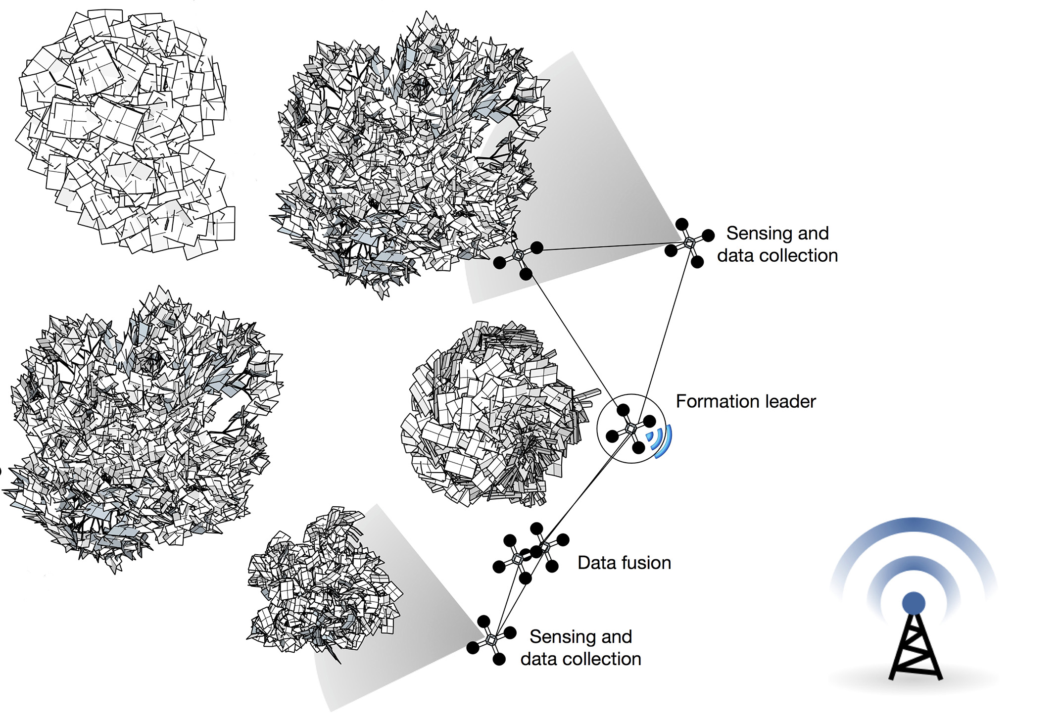
A UAV swarm can significantly increase the productivity and accuracy of data describing the forest as a set of three dimensional objects, each having multiple attributes attached (such as taper, infestation with damaging biotic agents, or thermal radiance) [6]. An illustration of a deployment of a UAV swarm in a forest area is shown in Fig. 1. Each UAV maintains communication capabilities with neighboring UAVs which are in its transmission range. The UAVs adapt to the unknown environment, circumvent obstacles, and map the forest with a variety of sensors. Afterwards, the swarm leader UAV transmits the collected and aggregated data to the base station or operator for data analysis and advanced post-processing.
However, the advantages promised by an autonomous UAV swarm face challenges that come with the efficient swarm formation and communication preservation. The set of UAVs should exhibit a swarm-like behavior that provides an adaptive and reliable network structure while fulfilling the required tasks for assessment of environment (e.g., tree dimensions, amount of light, or spatial variation of humidity inside the forest) [7, 8].
In this paper, we propose a solution for establishing swarm behavior and a network topology between a collection of UAVs, which are specifically deployed for the scenario of high-quality forest-mapping. Our approach applies a leader election algorithm to a set of autonomous micro UAVs. The leader will have tasks such as gathering information from the swarm collective and leading the swarm to the destination. The leader UAV is additionally in charge to communicate to the base station (cf. Fig. 1). The UAVs in the formation sense and observe the events in the environment and the more powerful leader collects and processes information from them and reacts in case of obstacle avoidance and acts as it the cause for route planning and maneuvers.
II Related Work
Although there is high interest in applications for UAVs in environmental monitoring, such as forest-mapping, airborne surveillance or space exploration, most approaches are focused on the usage of one UAV. One of the reasons is that formation, coordination and control of a UAV swarm system containing multiple UAVs induces additional challenges, such as three dimensional movements, which can be -hard.
Existing approaches for optimizing formation acquisition and maintenance mostly focus on coverage problems [9, 10]. A variant of the coverage problem is the maximal coverage problem, where packing of a maximum number of circles is required. For the two dimensional case the problem has a polynomial time solution [11].
When considering three dimensions, the question for optimal node positioning is called the sphere packing problem [12]. A related problem in geometry is the kissing number problem [13], which is the number of non-overlapping unit spheres arranged such that each sphere touches another.
The properties of network topologies resulting from random deployment of nodes in a three-dimensional area are studied by Ravelomanana [14]. Ravelomanana considers the k-connectivity problem, which looks for the lower bound of the transmission range , so that every node has at least direct neighbors.
Schleich et al. [10] propose a decentralized and localized approach for UAV mobility control, which optimizes the network connectivity. The approach maintains the connectivity via a tree-based overlay network, whereby the root is the base station. Their empirical results show that the maintenance of the connectivity can have a negative impact on the coverage while the overall connectivity can improve.
The main feature of our approach is that a multi-path communication structure is maintained while using only local information, thus its preserving locality. Consequently, the formation can effectively span over a significantly wider area. Furthermore, we also introduce a leader navigator in the swarm movement, which distinguishes our approach from classical swarm modeling approaches.
The traditional remote sensing techniques employed in forest resources assessment and monitoring rely on imaginary data often operating in the visible spectrum, which fail to provide useful information on cloudy days. Although remedies have been found, such as combining visible and infrared light [15] a more direct approach is the usage of UAVs, specifically when flying under the canopy. A significant reduction in data acquisition costs while increasing accuracy occurs when instead of one flying entity multiple UAVs are used [16, 17], which conducted studies on land use in the Congo Basin, where the ground was often obscured by clouds and, therefore, developed ways to create composite pictures of sources with visible and infrared light.
While UAV swarms approaches are popular in military, communication, and marine applications [18, 19], only few applications are focused on forestry, mainly in forest fire surveillance [20]. The scenario considered throughout this paper aims forest-mapping of healthy trees, and introduces a set of particular challenges to the UAV swarm movement, such as a continuous change of the communication topology due to the high occurrence of trees in a relatively reduced area, which differentiates it to existing approaches.
III Swarm System Model
In this section, we define a basic swarm system model and the formal notions used to describe it.
III-A UAV Swarm System Model
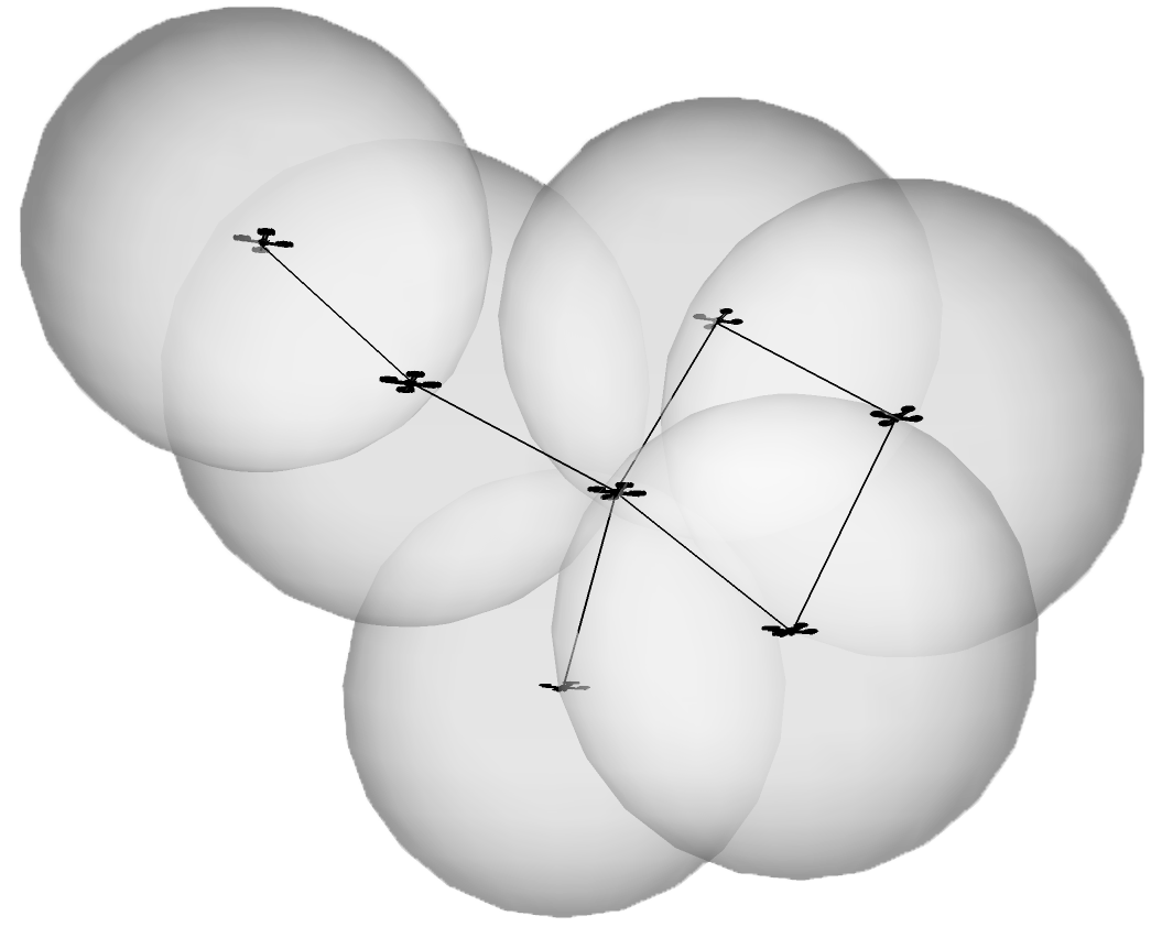
The communication network of a UAV swarm is represented by a symmetric Euclidean graph constructed such that is a set of UAV nodes in a three dimensional bounded region with side length . The UAV nodes are deployed according to a deployment model . The links in set of the graph fulfill the condition that for any pair of nodes, and , where is the effective transmission range for each . Each UAV can relocate to any position in . An exemplary swarm network topology, which results from our swarm system model is shown in Fig. 2.
Our work addresses the connections only and does not measure energy efficiency from a signal-point of view, but from a topological point of view; wherefore, we do not describe a radio propagation model here.
For each UAV node let there be a neighboring list , which is the set of UAVs directly connected to UAV , such that . The neighboring list is created initially and is updated with frequency , since the neighborhood of a node is subject to change.We further assume that each UAV node can communicate exclusively with its current direct neighbors (1-hop neighbors).
Since only localized communication is used, there is no need to establish multi-hop control communication. This specification guarantees complexity efficiency in our locality-preservation approach.
The swarm leader uses different ways to deliver data, which can be the submission of data if satellite or cellular communication is available at the base station. For this, the leader can stop periodically the swarm activity to fly above the tree crowns for data submission. The data can also be delivered after returning to the spatial proximity to the base station. However, in this paper we exclusively deal with the swarm behavior and networking aspects within the swarm. Swarm-to-base station communication is subject of future work.
One crucial objective for the deployment of a UAV swarm is to obtain accurate location information of the UAVs and the objects under investigations such as trees, the trees’ crown and canopy.
However, the inherent density of a forrest imposes an extreme challenge on on-site data collection: GPS is not a viable option in terms of availability and efficiency for UAVs. Additionally, thick forest structure may block satellite communication from time to time as the UAVs fly below the crowns and canopy.
Therefore, an autonomous UAV swarm needs to rely on a relative positioning system, where only a small subset of the UAVs relies on GPS, for planning or maneuvering.
Therefore, our model assumes that for each swarm only the leader UAV is in charge of absolute positions (e.g. GPS data or preinstalled maps). Therefore, the swarm leaders have a priori knowledge of their positions.
IV Approach: A Networked Swarm Model
Various requirements and challenges exist to assess unpredictable environments such as a forest using a UAV swarm. Differentiating features such as autonomous control or the continuous motion during the flight require the swarm to have a high resistance threshold concerning changes in positions, and the swarm must reorganize obstacles and overcome them. The algorithm for describing swarm movement and maintaining the network topology between the UAVs in the swarm is localized and fully distributed. Additionally, our approach does not require communication with a base station or the global positioning system.
IV-A Leader UAV and swarm communication network
The UAV swarm formation process needs to consider that in restricted settings, the leader UAV will be predetermined due to higher-energy resources and/or communication capabilities. Moreover, we aim at providing a scalable approach, in which the leader election is triggered in the initialization phase and re-triggered periodically during the flight. The possibility of changing the leader UAV allows the swarm to readjust to environmental conditions, and to maximize its operation efficiency.
In the first part of Algorithm 1, we deal with the communication network in the UAV swarm. The leader UAV and, subsequently, the communication structure in the swarm is determined. Initially, weights are assigned to each UAV, which change according to the conditions in Algorithm 1 to determine its function in the swarm communication network. The described procedure explicitly supports changes of UAVs in the network position, therefore, providing an adaptive and self-organizing approach.
IV-B Swarm movement and formation control
Our approach requires knowledge of destination only by the leader UAV. The additional swarm members follow the leader in a collision-free manner by adjusting their velocity according to the conditions that describe the behavior of the swarm.
To achieve this leader-follower model, we significantly altered the leaderless Boid model [21], and build a distributed formation-featured model that fulfills the swarm requirements for our application scenario. We propose the following extended conditions for the UAV swarm with a leader:
-
1.
The leader UAV receives its current position and destination.
-
2.
Each UAV (including the leader UAV) aligns with its direct neighbors.
-
3.
Each UAV (including the leader UAV) maintains direct connectivity with its neighbors.
-
4.
Each UAV (including the leader UAV) avoids collision with any UAV.
-
5.
The leader UAV approaches the destination.
These five conditions represent a complete description of the UAV movement. The first condition ensures that coordinates of the current position and the destination are known by the designated leader UAV. The leader respects all conditions, while moving towards destination. The second condition describes the behavior of a UAV in relationship with its neighbors and is responsible for alignment maintenance of the local group movement behavior. This condition is important to spatially organize the swarm and, in particular, to offer an enhanced coverage of the object under investigation (e.g. tree). Conditions three and four describe two opposing behaviors; the former reinforces UAV movements that preserve the swarm (i.e. relationships to its momentarily direct neighbors), while the latter ensures that swarm’s members are at a collide avoidance distance (i.e. preset minimum distance). The fifth condition serves primarily to direct the swarm to its destination. The procedure implementing the five conditions is formally described in the second part of Algorithm 1.
Local rules or conditions limit the increase in complexity induced by scenarios with large numbers of UAVs. Therefore, the proposed approach is scalable, as it can be applied to swarms with either few or multiple UAVs.
V Simulations and Results
Settings
We refer to the notions of the basic swarm system model in III for the descriptions of the simulation settings.
We define the UAV swarm as a graph constructed such that is a set of UAV nodes in a three dimensional bounded region with side length . The number of UAVs used is and the transmission range . The set is determined by the condition described in III, which states that for any pair of nodes and .
The UAV nodes are positioned according to the deployment model with coordinates (i.e., deployment) and (i.e., destination) whereby . The leader UAV velocity is .
The neighboring list will be created initially so that and updated with frequency .
The UAVs start in the simulation from virtually the same position. The leader UAV moves from the deployment coordinates to the destination coordinates with velocity . Algorithm 1 (re-)calculates the velocity vectors of each UAV such that the swarm maintains connectivity, but avoids collisions.


Simulation behavior
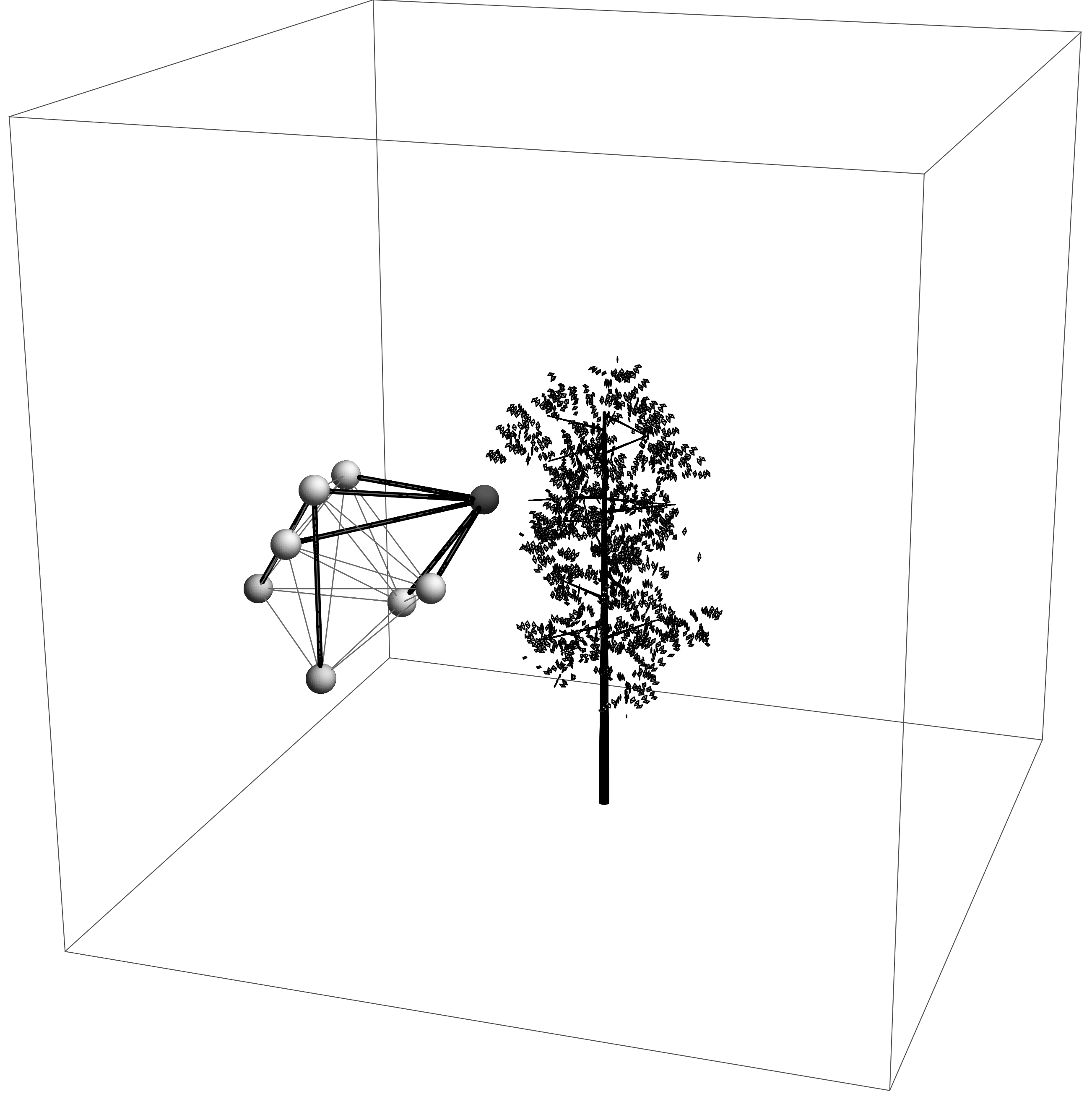
We implemented a UAV swarm simulator to visually and empirically verify the usability and performance of our proposed approach described in Algorithm 1. Simulation results for the simulation settings described in Section V are shown in Fig. 3.
Figure 3a shows that the UAVs are positioned randomly around the deployment coordinates . Noteworthy, the algorithm supports random position for each UAV in the simulation area.
Figure 3b shows that the leader election has been executed and that the leader UAV is directly connected to each of the UAVs in the swarm. Additionally, the leader UAV starts moving towards the destination coordinates .
Figure 3c shows that the leader UAV pushes the swarm towards the destination . Observe that only the leader knows the destination coordinates and the rest of the swarm follows the leader, while maintaining the swarm behavior.
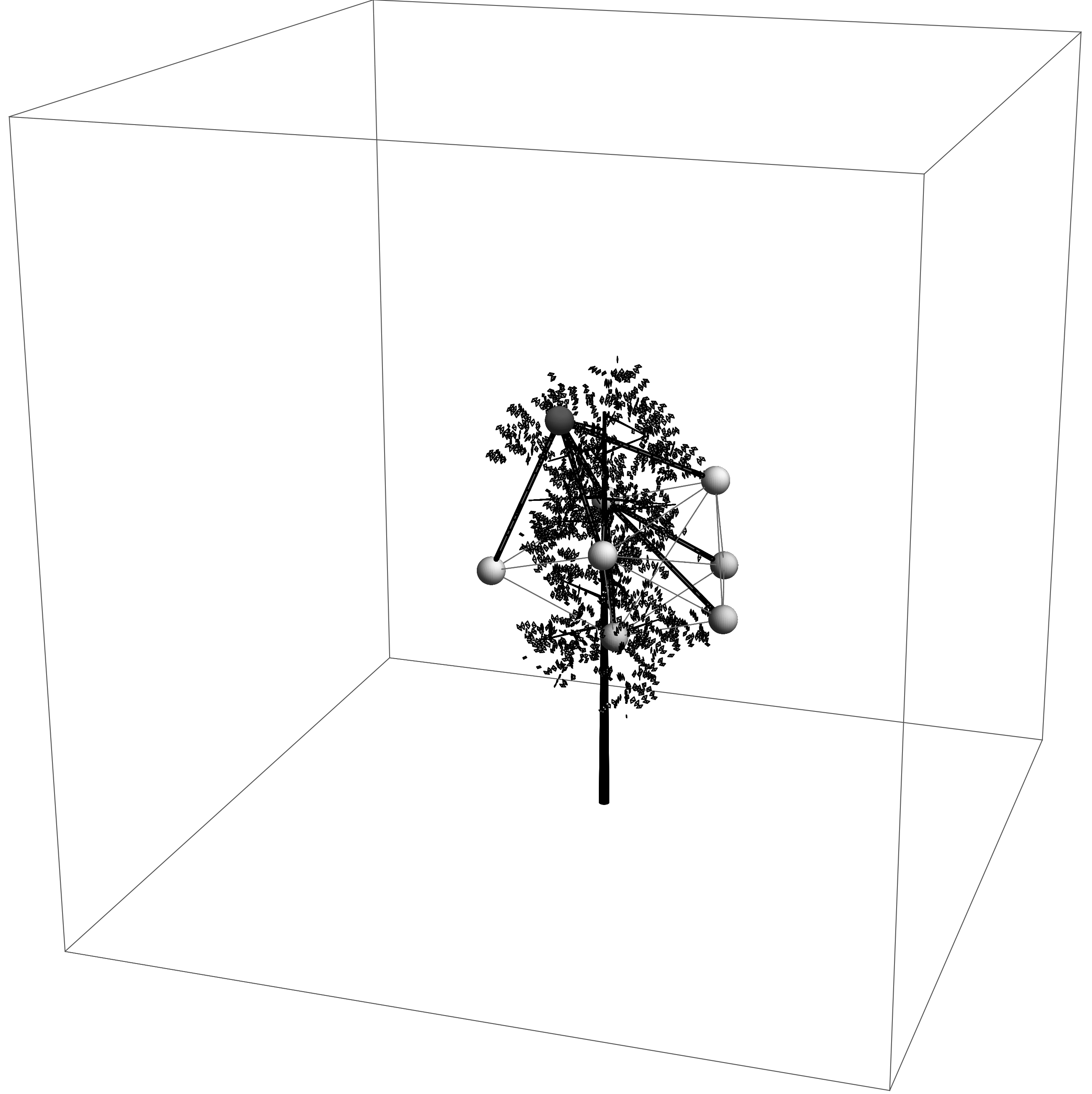
For initiation of the coverage procedure, we assume that the swarm’s movement to the destination has been realized with a lower transmission range, which keeps the UAVs closer and the swarm compact. Arriving at the destination coordinates the UAVs transmission is extended to its full range. Figure 3d shows the leader UAV arriving at the tree, which represents the destination. Subsequently, the UAV swarm forms a coverage around the tree, while maintaining full connectivity to the entire swarm. Each UAV is connected directly or over several hops to the leader UAV.
Time assessment
Although, the leader UAV pushes the UAV swarm towards the destination , the swarm movement procedure in Algorithm 1 induces a delay in the collective’s movement to avoid disconnection but at the same time to avoid collision between UAVs. Therefore, we are interested in the movement delay caused by our approach compared to a straight flight of solely the leader UAV from to .
For this, we conducted five runs of the simulation, each with a different number of UAVs (). We measured the time needed for the swarm to arrive at the tree () and compared this to the theoretical time, which is the time needed by only one UAV to fly directly with velocity from to . This quantitative measure reflects applicability and scalability of the proposed approach, since the swarm conditions impose influence on the overall task.
| Parameter | Value |
|---|---|
| Euclidean distance to destination | 129.9 |
| Velocity vector of the leader UAV | 0.7 |
| Theoretical time to destination | 185.57 |
| Run | |||
| 1 | 190 | 190 | 263 |
| 2 | 195 | 199 | 283 |
| 3 | 192 | 199 | 225 |
| 4 | 196 | 194 | 234 |
| 5 | 193 | 201 | 218 |
| Average | 193.2 | 196.6 | 244.6 |
Results in Table I and Fig. 4 show that the flying time from to (i.e. simulation time in discrete steps) does not differ significantly when 4 or 8 UAVs are deployed (i.e., from direct flight time), which is time increase for and for . However, for the case , we observe a considerable increase in time (i.e., 31%). For the envisioned scenario (i.e., the forest environment where we focus on assessing one or several trees) the number of UAVs below is realistic and practical.
VI Conclusions
We propose an approach for the formation flight problem for UAV swarms, which maintain connectivity and communicability. The two characteristics are important for detailed, precise, and accurate data collection and aggregation, and play a crucial role in assessing the forest environment. Our approach is based on local decision-making, and, therefore, assures low message and computation complexity, while providing scalability for a large number of UAVs in the swarm. Results indicate that the proposed swarm movement is almost as fast to reach the destination location as the theoretical approach comprising of just one UAV.
However, melding the aspects of swarm movement and communication network is more than a matter of concatenating two isolated aspects. Additional issues of optimal swarm positioning, such as ad hoc data fusion and object assessment (e.g. localization and mapping) will be addressed in future work.
References
- [1] F. Kendoul, “Survey of advances in guidance, navigation, and control of unmanned rotorcraft systems,” Journal of Field Robotics, vol. 29, no. 2, pp. 315–378, 2012.
- [2] A. Bürkle, F. Segor, and M. Kollmann, “Towards autonomous micro uav swarms,” Journal of intelligent & robotic systems, vol. 61, no. 1-4, pp. 339–353, 2011.
- [3] G. Danoy, M. R. Brust, and P. Bouvry, “Connectivity stability in autonomous multi-level uav swarms for wide area monitoring,” in ACM Symposium on Development and Analysis of Intelligent Vehicular Networks and Applications (ACM DIVANet), pp. 1–8, ACM, 2015.
- [4] B. Campbell James and H. Wynne Randolph, “Introduction to remote sensing,” 2011.
- [5] R. Shrestha and R. H. Wynne, “Estimating biophysical parameters of individual trees in an urban environment using small footprint discrete-return imaging lidar,” Remote Sensing, vol. 4, no. 2, pp. 484–508, 2012.
- [6] B. Strimbu and J. Innes, “An analytical platform for cumulative impact assessment based on multiple futures,” Journal of environmental management, vol. 92, no. 7, pp. 1740–1752, 2011.
- [7] M. R. Brust, D. Turgut, C. H. Ribeiro, and M. Kaiser, “Is the clustering coefficient a measure for fault tolerance in wireless sensor networks?,” in IEEE International Conference on Communications (ICC), pp. 183–187, IEEE, 2012.
- [8] M. R. Brust, M. İ. Akbaş, and D. Turgut, “Multi-hop localization system for environmental monitoring in wireless sensor and actor networks,” Wiley Journal on Concurrency and Computation: Practice and Experience, vol. 25, no. 5, pp. 701–717, 2011.
- [9] M. R. Brust, C. H. C. Ribeiro, J. A. B. Filho, J. Mesit, and R. K. Guha, “Effective Coverage Area and Network Density in Simulations of Ad hoc and Sensor Networks,” International Journal of Simulation - Systems, Science and Technology, vol. 10, no. 4, 2009.
- [10] J. Schleich, A. Panchapakesan, G. Danoy, and P. Bouvry, “Uav fleet area coverage with network connectivity constraint,” in Proceedings of the 11th ACM international symposium on Mobility management and wireless access, pp. 131–138, ACM, 2013.
- [11] C.-F. Huang and Y.-C. Tseng, “The coverage problem in a wireless sensor network,” Mobile Networks and Applications, vol. 10, no. 4, pp. 519–528, 2005.
- [12] T. C. Hales, “The sphere packing problem,” Journal of Computational and Applied Mathematics, vol. 44, no. 1, pp. 41–76, 1992.
- [13] O. R. Musin, “The kissing problem in three dimensions,” Discrete & Computational Geometry, vol. 35, no. 3, pp. 375–384, 2006.
- [14] V. Ravelomanana, “Extremal properties of three-dimensional sensor networks with applications,” Mobile Computing, IEEE Transactions on, vol. 3, no. 3, pp. 246–257, 2004.
- [15] M. C. Hansen, D. P. Roy, E. Lindquist, B. Adusei, C. O. Justice, and A. Altstatt, “A method for integrating modis and landsat data for systematic monitoring of forest cover and change in the congo basin,” Remote Sensing of Environment, vol. 112, no. 5, pp. 2495–2513, 2008.
- [16] C. Frey, D. Zarzhitsky, W. M. Spears, D. F. Spears, C. Karlsson, B. Ramos, J. C. Hamann, and E. A. Widder, “A physicomimetics control framework for swarms of autonomous surface vehicles,” in OCEANS 2008, pp. 1–6, IEEE, 2008.
- [17] J. L. Sanchez-Lopez, J. Pestana, P. de la Puente, R. Suarez-Fernandez, and P. Campoy, “A system for the design and development of vision-based multi-robot quadrotor swarms,” in Unmanned Aircraft Systems (ICUAS), 2014 International Conference on, pp. 640–648, IEEE, 2014.
- [18] Y. Wei, M. B. Blake, and G. R. Madey, “An operation-time simulation framework for uav swarm configuration and mission planning,” Procedia Computer Science, vol. 18, pp. 1949–1958, 2013.
- [19] S. Hauert, J.-C. Zufferey, and D. Floreano, “Evolved swarming without positioning information: an application in aerial communication relay,” Autonomous Robots, vol. 26, no. 1, pp. 21–32, 2009.
- [20] D. W. Casbeer, D. B. Kingston, R. W. Beard, and T. W. McLain, “Cooperative forest fire surveillance using a team of small unmanned air vehicles,” International Journal of Systems Science, vol. 37, no. 6, pp. 351–360, 2006.
- [21] C. W. Reynolds, “Flocks, herds and schools: A distributed behavioral model,” ACM SIGGRAPH Computer Graphics, vol. 21, no. 4, pp. 25–34, 1987.