The History of Mobile Augmented Reality
Abstract
This document summarizes the major milestones in mobile Augmented Reality between 1968 and 2014. Mobile Augmented Reality has largely evolved over the last decade, as well as the interpretation itself of what is Mobile Augmented Reality. The first instance of Mobile AR can certainly be associated with the development of wearable AR, in a sense of experiencing AR during locomotion (mobile as a motion). With the transformation and miniaturization of physical devices and displays, the concept of mobile AR evolved towards the notion of ”mobile device”, aka AR on a mobile device. In this history of mobile AR we considered both definitions and the evolution of the term over time.
Major parts of the list were initially compiled by the member of the Christian Doppler Laboratory for Handheld Augmented Reality in 2009 (author list in alphabetical order) for the ISMAR society. More recent work was added in 2013 and during preparation of this report.
Permission is granted to copy and modify. Please email the first author if you find any errors.
linksWeblinks
Introduction
This document summarizes the major milestones in mobile Augmented Reality between 1968 and 2014. Mobile Augmented Reality has largely evolved over the last decade, as well as the interpretation itself of what is Mobile Augmented Reality. The first instance of Mobile AR can certainly be associated with the development of wearable AR, in a sense of experiencing AR during locomotion (mobile as a motion). With the transformation and miniaturization of physical devices and displays, the concept of mobile AR evolved towards the notion of ”mobile device”, aka AR on a mobile device. In this history of mobile AR we considered both definitions and the evolution of the term over time.
Major parts of the list were initially compiled by the member of the The list was compiled by the member of the Christian Doppler Laboratory for Handheld Augmented Reality111CDL on Handheld AR: http://studierstube.org/handheld_ar/ in 2009 (author list in alphabetical order) for the ISMAR society. More recent work was added in 2013 and during preparation of this report.
Permission is granted to copy and modify. Please email the first author if you find any errors.
|
|
|
|
|
| (a) Research | (b) Mobile PC | (c) Mobile Phone | (d) Hardware |
|
|
|
|
|
| (e) Standard | (f) Game | (g) Tool | (h) Deal |
1968
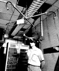
Ivan Sutherland [67] creates the first augmented reality system, which is also the first virtual reality system (see Fig.2 left). It uses an optical see-through head-mounted display that is tracked by one of two different 6DOF trackers: a mechanical tracker and an ultrasonic tracker. Due to the limited processing power of computers at that time, only very simple wireframe drawings could be displayed in real time.
1972
The first conceptual tablet computer was proposed in 1972 by Alan Kay, named the Dynabook [32]. The Dynabook was proposed as personal computer for children, having the format factor of a tablet with a mechanical keyboard (really similar design from the One Laptop per Child project started in 2005). The Dynabook is probably recognized as being the precursor of the tablet computers decades before the iPad (see Fig. 2).
1973
1982
The first laptop, the Grid Compass222http://home.total.net/~hrothgar/museum/Compass/ 1100 is released, which was also the first computer to use a clamshell design. The Grid Compass 1100 had an Intel 8086 CPU, 350 Kbytes of memory and a display with a resolution of 320x240 pixels, which was extremely powerful for that time and justified the enormous costs of 10.000 USD. However, its weight of 5kg made it hardly portable.
1992
Tom Caudell and David Mizell coin the term ”augmented reality” to refer to overlaying computer-presented material on top of the real world [8] (see Fig.2). Caudell and Mizell discuss the advantages of AR versus VR such as requiring less processing power since less pixels have to be rendered. They also acknowledge the increased registration requirements in order to align real and virtual.
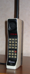
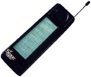
At COMDEX 1992, IBM and Bellsouth introduce the first smartphone, the IBM Simon Personal Communicator333Wikipedia: http://en.wikipedia.org/wiki/Simon_(phone), which was released in 1993 (see Fig.2). The phone has 1 Megabyte of memory and a B/W touch screen with a resolution of 160 x 293 pixels. The IBM Simon works as phone, pager, calculator, address book, fax machine, and e-mail device. It weights 500 grams and cost 900 USD.
1993
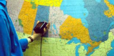
Loomis et al. develop a prototype of an outdoor navigation system for visually impaired [39]. They combine a notebook with a differential GPS receiver and a head-worn electronic compass. The application uses data from a GIS (Geographic Information System) database and provides navigational assistance using an ”acoustic virtual display”: labels are spoken using a speech synthesizer and played back at correct locations within the auditory space of the user.
Fitzmaurice creates Chameleon (see Fig.3), a key example of displaying spatially situated information with a tracked hand-held device. In his setup the output device consists of a 4” screen connected to a video camera via a cable [16]. The video camera records the content of a Silicon Graphics workstation’s large display in order to display it on the small screen. Fitzmaurice uses a tethered magnetic tracker (Ascension bird) for registration in a small working environment. Several gestures plus a single button allow the user to interact with the mobile device. Chameleon’s mobility was strongly limited due to the cabling. It did also not augment in terms of overlaying objects on a video feed of the real world.
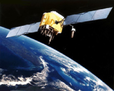
In December 1993 the Global Positioning System (GPS, official name ”NAVSTAR-GPS”) achieves initial operational capability (see Fig.3). Although GPS444Wikipedia: http://en.wikipedia.org/wiki/Global_Positioning_System was originally launched as a military service, nowadays millions of people use it for navigation and other tasks such as geo-caching or Augmented Reality. A GPS receiver calculates its position by carefully timing the signals sent by the constellation of GPS satellites. The accuracy of civilian GPS receivers is typically in the range of 15 meter. More accuracy can be gained by using Differential GPS (DGPS) that uses correction signals from fixed, ground-based reference stations.
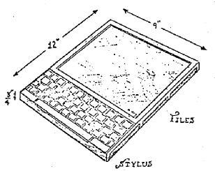
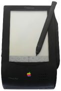
The Apple Newton Message Pad 100 was one of the earliest commercial personal digital assistant (PDA)555Wikipedia: http://en.wikipedia.org/wiki/MessagePad. Equipped with a stylus and handwritten recognition, and feature a screen in black and white of 336x240 pixels (see Fig. 3).
1994
Steve Mann starts wearing a webcam for almost 2 years. From 1994-1996 Mann wore a mobile camera plus display for almost every waking minute. Both devices were connected to his website allowing online visitors to see what Steve was seeing and to send him messages that would show up on his mobile display666S. Mann, “Wearable Wireless Webcam,” personal WWW page. wearcam.org
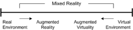

Paul Milgram and Fumio Kishino write their seminal paper ”Taxonomy of Mixed Reality Visual Displays” in which they define the Reality-Virtuality Continuum [41] (see Fig.4). Milgram and Kishino describe a continuum that spans from the real environment to the virtual environment. In between there are Augmented Reality, closer to the real environment and Augmented Virtuality, which is closer to the virtual environment. Today Milgram’s Continuum and Azuma’s definition (1997) are commonly accepted as defining Augmented Reality.
1995
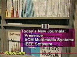
Jun Rekimoto and Katashi Nagao create the NaviCam, a tethered setup, similar to Fitzmaurice’s Chameleon [58] (see Fig.4). The NaviCam also uses a nearby powerful workstation, but has a camera mounted on the mobile screen that is used for optical tracking. The computer detects color-coded markers in the live camera image and displays context sensitive information directly on top of the video feed in a see-through manner.
Benjamin Bederson introduced the term Audio Augmented Reality by presenting a system that demonstrated an augmentation of the audition modality [5]. The developed prototype uses a MD-player which plays audio information based on the tracked position of the user as part of a museum guide.
1996
Jun Rekimoto presents 2D matrix markers777http://www.sonycsl.co.jp/person/rekimoto/matrix/Matrix.html (square-shaped barcodes), one of the first marker systems to allow camera tracking with six degrees of freedom [57] (see Fig.4).
1997
Ronald Azuma presents the first survey on Augmented Reality. In his publication, Azuma provides a widely acknowledged definition for AR [4], as identified by three characteristics:
-
•
it combines real and virtual
-
•
it is interactive in real time
-
•
it is registered in 3D.
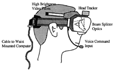
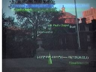
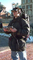
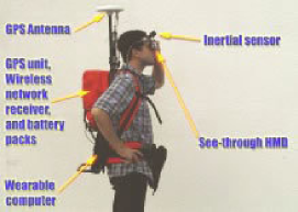
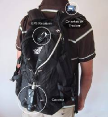
Steve Feiner et al. present the Touring Machine, the first mobile augmented reality system (MARS) [15] (see Fig.4 and Fig. 4). It uses a see-through head-worn display with integral orientation tracker; a backpack holding a computer, differential GPS, and digital radio for wireless web access; and a hand-held computer with stylus and touchpad interface888MARS: http://graphics.cs.columbia.edu/projects/mars/mars.html.
Thad Starner et al. explore possible applications of mobile augmented reality, creating a small community of users equipped with wearable computers interconnected over a network [66]. The explored applications include an information system for offices, people recognition and coarse localization with infrared beacons.
Philippe Kahn invents the camera phone999Wikipedia Camera Phone: http://en.wikipedia.org/wiki/Camera_phone, a mobile phone which is able to capture still photographs (see Fig.5). Back in 1997, Kahn used his invention to share a picture of his newborn daughter with more than 2000 relatives and friends, spread around the world. Today more than half of all mobile phones in use are camera phones.
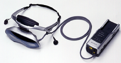
Sony releases the Glasstron, a series of optical HMD (optionally see-through) for the general public. Adoption was rather small, but the affordable price of the HMD made it really popular in AR research labs and for the development of wearable AR prototype (see Fig. 5).
1998

Bruce Thomas et al. present ”Map-in-the-hat”, a backpack-based wearable computer that includes GPS, electronic compass and a head-mounted display [71] (see Fig.5). At this stage the system was utilized for navigation guidance, but it later evolved into Tinmith, an AR platform used for several other AR projects101010Tinmith webpage: http://www.tinmith.net/.
1999
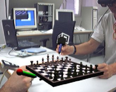
Hirokazu Kato and Mark Billinghurst present ARToolKit, a pose tracking library with six degrees of freedom, using square fiducials and a template-based approach for recognition [31]. ARToolKit is available as open source under the GPL license and is still very popular in the AR community (see Fig. 5).
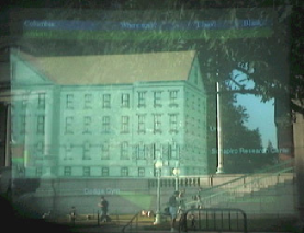
Tobias Höllerer et al. develop a mobile AR system that allows the user to explore hypermedia news stories that are located at the places to which they refer and to receive a guided campus tour that overlays models of earlier buildings [26] (see Fig. 6). This was the first mobile AR system to use RTK GPS and an inertial-magnetic orientation tracker.
Tobias Höllerer et al. present a mobile augmented reality system that includes indoor user interfaces (desktop, AR tabletop, and head-worn VR) to interact with the outdoor user [27] (see Fig. 6). While outdoor users experience a first-person spatialized multimedia presentation via a head-mounted display, indoor users can get an overview of the outdoor scene.
Jim Spohrer publishes the Worldboard concept, a scalable infrastructure to support mobile applications that span from low-end location-based services, up to high-end mobile AR [65]. In his paper, Spohrer also envisions possible application cases for mobile AR, and social implications.
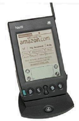
The first consumer LBS device was the Palm VII, only supporting zip code based location services (see Fig.5). 2 years later, different mobile operators provided different location based services using private network technology111111Wikipedia: http://en.wikipedia.org/wiki/Palm_VII.
Benefon Esc! NT2002121212http://www.benefon.de/products/esc/, the first GSM phone with a built-in GPS receiver is released in late 1999 (see Fig. 6). It had a black and white screen with a resolution of 100x160 pixels. Due to limited storage, the phone downloaded maps on demand. The phone also included a friend finder that exchanged GPS positions with other Esc! devices via SMS.
The wireless network protocols 802.11a/802.11b131313Wikipedia: http://en.wikipedia.org/wiki/802.11 - commonly known as WiFi - are defined. The original version - obsolete - specifies bitrates of 1 or 2 megabits per second (Mbit/s), plus forward error correction code.
2000
Bruce Thomas et al. present AR-Quake, an extension to the popular desktop game Quake [70] (see Fig. 7). ARQuake is a first-person perspective application which is based on a 6DOF tracking system using GPS, a digital compass and vision-based tracking of fiducial markers. Users are equipped with a wearable computer system in a backpack, an HMD and a simple two-button input device. The game can be played in- or outdoors where the usual keyboard and mouse commands for movement and actions are performed by movements of the user in the real environment and using the simple input interface.
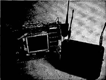
Regenbrecht and Specht present mPARD, using analogue wireless video transmission to a host computer which is taking the burden of computation off the mobile hardware platform [54] (see Fig. 7). The rendered and augmented images are sent back to the visualization device over a separate analog channel. The system can operate within 300m outdoors and 30m indoors, and the batteries allow for an uninterrupted operation of 5 hours at max.
Fritsch et al. introduce a general architecture for large scale AR system as part of the NEXUS project. The NEXUS model introduces the notion of augmented world using distributed data management and a variety of sensor system [17].
Simon Julier et al. present BARS, the Battlefield Augmented Reality System [29] (see Fig. 7). The system consists of a wearable computer, a wireless network system and a see-through HMD. The system targets the augmentation of a battlefield scene with additional information about environmental infrastructure, but also about possible enemy ambushes.

Sharp corporation releases the first commercial camera phone to public (see Fig. 7). The official name of the phone is J-SH04141414http://k-tai.impress.co.jp/cda/article/showcase_top/3913.html. The phones’ camera has a resolution of 0.1 megapixels.
At ISAR, Julier et al. described the problem of information overload and visual clutter within mobile Augmented Reality [28]. They proposed information filtering for mobile AR based on techniques such as physically-based methods, methods using the spatial model of interaction, rule-based filtering, and a combination of these methods to reduce the information overload in mobile AR scenarios.

2001
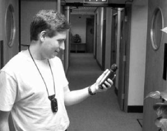
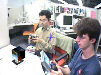
Joseph Newman et al. present the BatPortal [49], a PDA-based, wireless AR system (see Fig.8). Localization is performed by measuring the travel time of ultra-sonic pulses between specially built devices worn by the user, so-called Bats, and fixed installed receivers deployed in the floors ceilings building-wide. The system can support an HMD-based system, but also the more well known BatPortal using a handheld device. Based on a fixed configuration of the PDA carried and the personal Bat worn, the direction of the users view is estimated, and a model of the scene with additional information about the scene is rendered onto the PDA screen.
Hara et al. introduce TOWNWEAR, an outdoor system that uses a fiber optic gyroscope for orientation tracking [62] (see Fig.8). The high precision gyroscope is used to measure the 3DOF head direction accurately with minimal drift, which is then compensated by tracking natural features.
Jürgen Fruend et al. present AR-PDA, a concept for building a wireless AR system and a special prototype of palm-sized hardware [18] (see Fig.8). Basic design ideas include the augmentation of real camera images with additional virtual objects, for example for illustration of functionality and interaction with commonly used household equipment.
Reitmayr and Schmalstieg present a mobile, multi-user AR system [55] (see Fig.8). The ideas of mobile augmented reality and collaboration between users in augmented shared space are combined and merged into a hybrid system. Communication is performed using LAN and wireless LAN, where mobile users and stationary users are acting in a common augmented space.
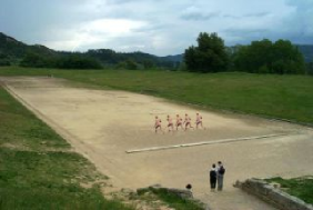
Vlahakis et al. present Archeoguide, a mobile AR system for cultural heritage sites [73] (see Fig.8). The system is built around the historical site of Olympia, Greece. The system contains a navigation interface, 3D models of ancient temples and statues, and avatars which are competing for the win in the historical run in the ancient Stadium. While communication is based on WLAN, accurate localization is performed using GPS. Within the system a scalable setup of mobile units can be used, starting with a notebook sized system with HMD, down to palmtop computers and Pocket PCs.
Kretschmer et al. present the GEIST system, a system for interactive story-telling within urban and/or historical environments [36]. A complex database setup provides information queues for the appearance of buildings in ancient times or historical facts and events. Complex queries can be formulated and stories can be told by fictional avatars or historical persons.
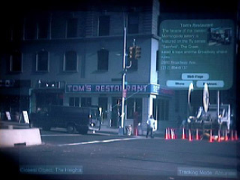
Columbia’s Computer Graphics and User Interfaces Lab does an outdoor demonstration of their mobile AR restaurant guide at ISAR 2001, running on their Touring Machine [6] (see Fig.8). Pop-up information sheets for nearby restaurants are overlaid on the user’s view, and linked to reviews, menus, photos, and restaurant URLs.
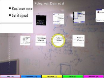
Kooper and MacIntyre create the RWWW Browser, a mobile AR application that acts as an interface to the World Wide Web [35] (see Fig.8). It is the first AR browser. This early system suffers from the cumbersome AR hardware of that time, requiring a head mounted display and complicated tracking infrastructure. In 2008 Wikitude implements a similar idea on a mobile phone.

2002
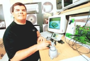
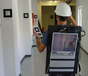
Michael Kalkusch et al. present a mobile augmented reality system to guide a user through an unfamiliar building to a destination room [30] (see Fig. 9). The system presents a world-registered wire frame model of the building labeled with directional information in a see-through heads-up display, and a three-dimensional world-in-miniature (WIM) map on a wrist-worn pad that also acts as an input device. Tracking is done using a combination of wall-mounted ARToolkit markers observed by a head-mounted camera, and an inertial tracker.
Leonid Naimark and Eric Foxlin present a wearable low-power hybrid visual and inertial tracker [46]. This tracker, later to be known as InterSense’s IS-1200, can be used for tracking in large scale, such as a complete building. This is achieved by tracking a newly designed 2-D barcode with thousands of different codes and combining the result with an inertial sensor.
2003
Adrian David Cheok et al. present the Human Pacman [9] (see Fig. 9). Human Pacman is an interactive ubiquitous and mobile entertainment system that is built upon position and perspective sensing via Global Positioning System and inertia sensors; and tangible human-computer interfacing with the use of Bluetooth and capacitive sensors. Pacmen and Ghosts are now real human players in the real world experiencing mixed computer graphics fantasy-reality provided by using wearable computers that are equipped with GPS and inertia sensors for players’ position and perspective tracking. Virtual cookies and actual tangible physical objects with Bluetooth devices and capacitive sensors are incorporated into the game play to provide novel experiences of seamless transitions between real and virtual worlds.
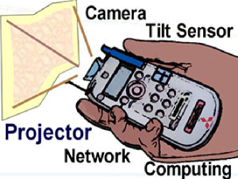
Ramesh Raskar et al. present iLamps [53] (see Fig. 9). This work created a first prototype for object augmentation with a hand-held projector-camera system. An enhanced projector can determine and respond to the geometry of the display surface, and can be used in an ad-hoc cluster to create a self-configuring display. Furthermore interaction techniques and co-operation between multiple units are discussed.
Daniel Wagner and Dieter Schmalstieg present an indoor AR guidance system running autonomously on a PDA [77] (see Fig. 9). They exploit the wide availability of consumer devices with a minimal need for infrastructure. The application provides the user with a three-dimensional augmented view of the environment by using a Windows Mobile port of ARToolKit for tracking and runs directly on the PDA.
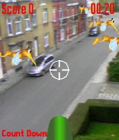
The Siemens SX1 is released, coming with the first commercial mobile phone AR camera game called Mozzies (also known as Mosquito Hunt) (see Fig. 9). The mosquitoes are superimposed on the live video feed from the camera. Aiming is done by moving the phone around so that the cross hair points at the mosquitoes. Mozzies was awarded the title of best mobile game in 2003.
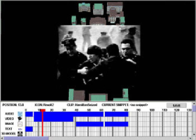
Sinem Guven presents a mobile AR authoring system for creating and editing 3D hypermedia narratives that are interwoven with a wearable computer user’s surrounding environment151515http://graphics.cs.columbia.edu/projects/mars/Authoring.html [22] (see Fig. 9). Their system was designed for authors who are not programmers and used a combination of 3D drag-and-drop for positioning media and a timeline for synchronization. It allowed authors to preview their results on a desktop workstation, as well as with a wearable AR or VR system.
2004
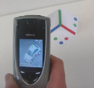
Mathias Möhring et al. present a system for tracking 3D markers on a mobile phone [44] (see Fig.10). This work showed a first video see-through augmented reality system on a consumer cell-phone. It supports the detection and differentiation of different 3D markers, and correct integration of rendered 3D graphics into the live video stream.
Michael Rohs and Beat Gfeller present Visual Codes, a 2D marker system for mobile phones [59] (see Fig.10). These codes can be attached to physical objects in order to retrieve object-related information and functionality. They are also suitable for display on electronic screens.
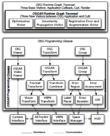
Enylton Machado Coelho et al. presents OSGAR, a scene graph with uncertain transformations [10] (see Fig.10). In their work they target the problem of registration error, which is especially important for mobile scenarios when high quality tracking is not available and overlay graphics will not align perfectly with the real environment. OSGAR dynamically adapts the display to mitigate the effects of registration errors.
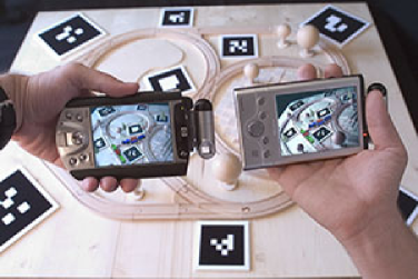
The Invisible Train, is shown at SIGGRAPH 2004 Emerging Technologies161616The Invisible Train: http://studierstube.icg.tugraz.at/invisible_train/ (see Fig.10). The Invisible Train is the first multi-user Augmented Reality application for handheld devices [75].
2005
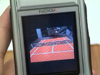
Anders Henrysson ports ARToolKit to Symbian [23] (see Fig.11). Based on this technology he presents the famous AR-Tennis game, the first collaborative AR application running on a mobile phone. ARTennis was awarded the Indepdent Mobile Gaming best game award for 2005, and the technical achievement award.
Project ULTRA shows how to use non-realtime natural feature tracking on PDAs to support people in multiple domains such as the maintenance and support of complex machines, construction and production, and edutainment and cultural heritage [40]. Furthermore an authoring environment is developed to create the AR scenes for the maintenance tasks.
The first mobile phones equipped with three-axis accelerometers were the Sharp V603SH and the Samsung SCH-S310 both sold in Asia in 2005.
2006
Reitmayr and Drummond present a model-based hybrid tracking system for outdoor augmented reality in urban environments enabling accurate, real-time overlays on a handheld device [56] (see Fig.11). The system combines an edge-based tracker for accurate localization, gyroscope measurements to deal with fast motions, measurements of gravity and magnetic field to avoid drift, and a back store of reference frames with online frame selection to re-initialize automatically after dynamic occlusions or failures.
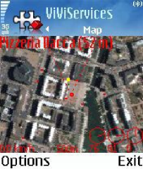
Nokia presents Mara, a multi-sensor mobile phone AR guidance application for mobile phones171717Mara: http://research.nokia.com/page/219. The prototype application overlays the continuous viewfinder image stream captured by the camera with graphics and text in real time, annotating the user’s surroundings (see Fig.11).
2007
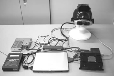
Klein and Murray present a system capable of robust real-time tracking and mapping in parallel with a monocular camera in small workspaces [33] (see Fig. 12). It is an adaption of a SLAM approach which processes the tracking and mapping task on two separated threads.
DiVerdi and Höllerer present the GroundCam, a system combining a camera and an orientation tracker [12] (see Fig. 12). The camera points at the ground behind the user and provides 2D tracking information. The method is similar to that of an optical desktop mouse.


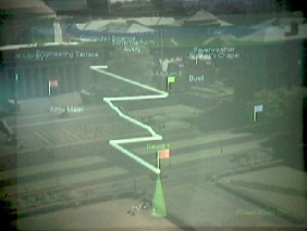
Rohs et al. compare the performance of the following navigation methods for map navigation on mobile devices: joystick navigation, the dynamic peephole method without visual context, and the magic lens paradigm using external visual context [60] (see Fig. 12). In their user study they demonstrate the advantage of dynamic peephole and magic lens interaction over joystick interaction in terms of search time and degree of exploration of the search space.
The first multi-touch screen mobile phone, famously known as iPhone sold by Apple, leverages a new way to interact on mobile devices (see Fig. 12).
HIT Lab NZ and Saatchi deliver the world’s first mobile phone based AR advertising application for the Wellington Zoo \citelinksHIT08 (see Fig. 12).
2008
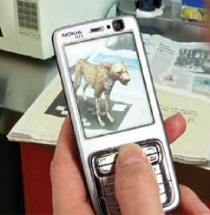
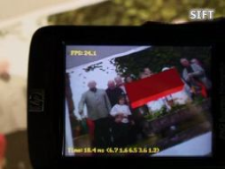
Wagner et al. present the first 6DOF implementation of natural feature tracking in real-time on mobile phones achieving interactive frame rates of up to 20 Hz [76] (see Fig. 13). They heavily modify the well known SIFT and Ferns methods in order to gain more speed and reduce memory requirements.
METAIO presents a commercial mobile AR museum guide using natural feature tracking or a six-month exhibition on Islamic art [42] (see Fig. 13). In their paper they describe the experiences made in this project.
With Augmented Reality 2.0, Schmalstieg et al. presented at the Dagstuhl seminar in 2008 for the first time a concept that combined ideas of the Web 2.0 such as social media, crowd sourcing through public participation, and an open architecture for content markup and distribution, and applied it to mobile Augmented Reality to create a scalable AR experience [63].
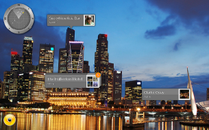
Mobilizy launches Wikitude181818Wikitude: http://www.mobilizy.com/wikitude.php?lang=en, an application that combines GPS and compass data with Wikipedia entries. The Wikitude World Browser overlays information on the real-time camera view of an Android smartphone (see Fig. 13).
2009
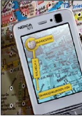
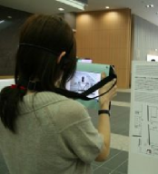
Morrison et al. present MapLens which is a mobile augmented reality (AR) map using a magic lens over a paper map [45] (see Fig. 14). They conduct a broad user study in form of an outdoor location-based game. Their main finding is that AR features facilitate place-making by creating a constant need for referencing to the physical. The field trials show that the main potential of AR maps lies in their use as a collaborative tool.

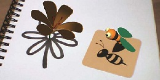

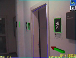
Hagbi et al. presented an approach allowing to track the pose of the mobile device by pointing it to fiducials [7] (see Fig. 14). Unlike existing systems the approach allows to track a wide set of planar shapes while the user can teach the system new shapes at runtime by showing them to the camera. The learned shapes are then maintained by the system in a shape library enabling new AR application scenarios in terms of interaction with the scene but also in terms of fiducial design.
Sean White introduces SiteLens (see Fig. 14), a hand-held mobile AR system for urban design and urban planning site visits [78]. SiteLens creates ”situated visualizations” that are related to and displayed in their environment. For example, representations of geocoded carbon monoxide concentration data are overlaid at the sites at which the data was recorded.
SPRXmobile launches Layar191919LayAR: http://layar.eu/, an advanced variant of Wikitude (see Fig. 14). Layar uses the same registration mechanism as Wikitude (GPS + compass), and incoperates this into an open client-server platform. Content layers are the equivalent of web pages in normal browsers. Existing layers include Wikipedia, Twitter and Brightkite to local services like Yelp, Trulia, store locators, nearby bus stops, mobile coupons, Mazda dealers and tourist, nature and cultural guides. On August 17th Layar went global serving almost 100 content layers.
Kimberly Spreen et al. develop ARhrrrr!, the first mobile AR game with high quality content at the level of commercial games\citelinksGT09 (see Fig. 14). They use an NVIDIA Tegra developer kit (”Concorde”) with a fast GPU. All processing except for tracking are running on the GPU, making the whole application run at high frame rates on a mobile phone class device despite the highly detailed content and natural feature tracking.
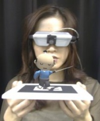
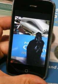
Georg Klein presents a video showing his SLAM system running in real-time on an iPhone [34] (see Fig. 14) and later presents this at ISMAR 2009 in Orlando, Florida. Even though it has constrains in terms of working area it is the first time a 6DoF SLAM system is known to run on mobile phones in sufficient speed.
Update April 2015:
The following parts of the document until beginning of 2015 cover the years since the last homepage update, following the same categorization and scheme as before.
From end of 2009 onwards, AR research and development is generally driven by high expectations and huge investments from world-leading companies such as Microsoft, Google, Facebook, Qualcomm and others. At the same time, the landscape of mobile phone manufacturers started to change radically.
In general the advances in mobile device capabilities introduce a strong drive towards mobile computing, and the availability of cloud processing further supports the proposal and development of server-client solutions for AR purposes. One major trend starting around 2010, originating by the work of Davison in 2003 [11] and later further explored by Klein and Murray [33, 34], is the heavy use of SLAM in AR, which still continues to dominate a major part of AR research and development as of beginning of 2015.
Microsoft presents ”Project Natal” at the game exhibition E3. It is the first version of a new hardware interface, consisting of motion detection technology, microphone, color camera and software, to be integrated into the game console Xbox 360.
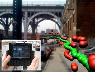
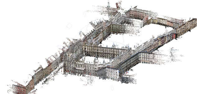
At ISMAR 2009, Clemens Arth et al. present a system for large-scale localization and subsequent 6DOF tracking on mobile phones [3]. The system uses sparse point clouds of city areas and FAST corners and SURF-like descriptors that can be used on memory-limited devices (see Fig. 15).
Qualcomm Inc. acquires the mobile AR IP from Imagination Computer Services GmbH., Vienna, and takes over the funding of the Christian Doppler Laboratory for Handheld AR at Graz University of Technology. A research center to focus on AR is opened later in 2010 in Vienna \citelinksQC10.

2010
A real-time panoramic mapping and tracking system for mobile phones is presented by Wagner et al. at VR, which performs 3DOF tracking in cylindric space and supports the use of panoramic imagery for improved usability and experience in AR [74] (see Fig. 15).
KHARMA is a lightweight and open architecture for referencing and delivering content explicitly aiming for mobile AR applications running on a global scale. It uses KML for describing the geospatial or relative relation of content while utilizing on HTML, JavaScript and CSS technologies for content development and delivery [25].
Microsoft announces a close cooperation with Primesense \citelinksMS10, an Israeli company working on structured-light based 3D sensors, to supply their technology to ”Project Natal”, now coined Kinect. The Kinect becomes commercially available in November 2010.
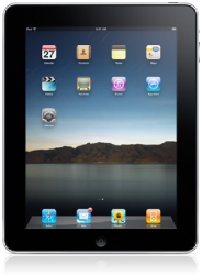
Apple releases the iPad202020Wikipedia: http://en.wikipedia.org/wiki/IPad on April 2010, which becomes the first tablet computer to be adopted by the large public. The iPad featured an assisted GPS, accelerometers, magnetometers, advanced graphics chipset (PowerVR SGX535), enabling the possibilities to create efficient AR application on tablet computer (see Fig. 15).
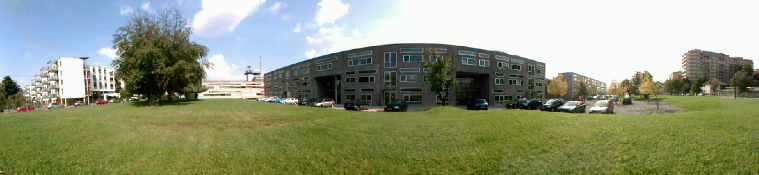
At ISMAR Lukas Gruber et al. present the ”City of Sights”, a collection of datasets and paperboard models212121http://studierstube.icg.tugraz.at/handheld_ar/cityofsights.php to evaluate the tracking and reconstruction performance of algorithms used in AR [20] (see Fig. 15).
After several delays, Microsoft releases Windows Phone in October 2010, to become the third major mobile phone operating system to challenge iOS and Android.
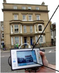
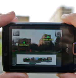
Existing mobile AR applications where exclusively used to browser and consume digital information. Langlotz et al. presented an new approach aiming for AR browsers that also supported creation of digital information in-situ. The information is registered with pixel-precision by utilizing a panorama of the environment that is created in the background [37] (see Fig. 15).
2011
Qualcomm announces the release of its AR platform SDK to the public in April. At that time it is called QCAR \citelinksQC11, which will later be called Vuforia.
In August, Google announces the acquisition of Motorola Mobility for about $12.5 billion \citelinksGO11. A major asset of Motorola is a large patent portfolio, which Google needs to secure the further Android platform development.
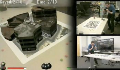
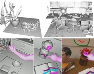
At ICCV 2011, Newcombe presents DTAM, a dense real-time tracking and mapping algorithm [48]. Later at ISMAR 2011, Richard Newcombe presents the KinectFusion work [47], in which depth images from the Kinect sensor are fused to create a single implicit surface model. KinectFusion becomes publicly available within the Kinect SDK later \citelinksKF11 (see Fig. 16).

Qi Pan presents his work on reconstructing scenes on mobile phones using panoramic images. By using FAST corners and a SURF-like descriptor, multiple panoramas are registered and a triangulated model is created after voxel carving [50] (see Fig. 16).
Following the still challenging problem of running SLAM in real-time on mobiles, Pirchheim presents an approach using planarity assumptions, and demonstrates his approach on a Nokia N900 smartphone [51].
Grubert et al. publish a technical report about the plausibility of using AR browsers [21], which becomes a survey about the pros and cons of AR browser technology at that point in time.
2012
Smart watches are broadly introduced as a new generation of mobile wearables. Pebble and the Sony SmartWatch are built to connect to a personal smartphone and to provide simple functionality, such as notifications or call answering.
Google Glass (also known as Google Project Glass) is firstly presented to the public222222Google Glass project page on Google+: https://plus.google.com/+GoogleGlass (see Fig.17). Goggle Glass is is an optical HMD that can be controlled with an integrated touch-sensitive sensor or natural language commands. After it’s public announcement Google Glass had a major impact on research but even more on the public perception of mixed reality technology.
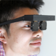
NVidia is demonstrating at Siggraph Emerging Technologies their prototype of a head mounted display supporting accurate accommodation, convergence, and binocular-disparity depth cues (see Fig. 17). The prototype introduces a light-field-based approach to near-eye displays and can be seen as a next generation wearable display technology for AR as existing hardware can’t provide accurate acommodation \citelinksNV12.
13th lab released the first commercial mobile SLAM (Simultaneous localization and mapping) system coined Pointcloud232323Pointcloud homepage: http://pointcloud.io/ to the public, marking a major milestone for app developers who want to integrate SLAM-based tracking into their application242424Pointcloud video: http://www.youtube.com/watch?v=K5OKaK3Ay8U.
PrimeSense, the creator of the Microsoft Kinect, introduced a smaller version of a 3D sensing device called Capri \citelinksPS12 that is small enough to be integrated into mobile devices such as tablets or smartphones252525Capri Video: http://www.youtube.com/watch?v=ELTETXO02zE.
At ISMAR 2012, Steffen Gauglitz et al. present their approach on tracking and mapping from both general and rotation-only camera motion [19].
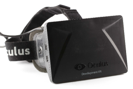
In August, Oculus VR announces the Oculus Rift dev kit, a virtual reality head-mounted display. This initiated a new hype in Virtual Reality and in the development of more head-mounted displays for gaming purposes mainly (see Fig.17).
2013
As opposed to previous work from Gauglitz et al., Pirchheim et al. present an approach to handle pure camera rotation running on a mobile phone at ISMAR [52].

Google Glass, which was already announced as Project Glass in 2012, becomes available through the explorer program in late 2013. and raises positive and negative attention, as well as concerns about privacy and ethical aspects (see Fig.17).
At ICRA, Li et al. present an amazing approach for motion tracking with inertial sensors and a rolling-shutter camera running in real-time on a mobile phone [38].
Tan et al. propose an approach to SLAM working in dynamic environments, allowing parts in the scene to be dynamic without breaking the mapping and tracking [68].
On November 24, 2013, Apple Inc. confirms the purchase of PrimeSense for about $350 million \citelinksAP13. Primesense was working on shrinking their sensors to fit into mobiles at that point in time.
Taskanen et al. propose an approach to perform full 3D reconstruction on a mobile monocular smartphone and creating a dense 3D model with known absolute scale [69].
2014
Three years after the acquisition, in January Google sells Motorola Mobility to Lenovo for $2.91 million, however, keeping most of the patent portfolio \citelinksGO14.
Also in January, Qualcomm acquires Kooaba \citelinksQC14, a Swiss ETH-spin-off founded in 2007, built around image recognition using SURF features. Kooaba’s technology is integrated into the services provided through the Vuforia SDK.
In February, Google announces Project Tango \citelinksGO142, which is an Android smartphone equipped with a full Kinect-like 3D sensor and hands out a few hundred units to developers and companies.
In March, Facebook acquires Oculus VR for $2 billion, although Oculus does not make any consumer products at that point in time yet \citelinksFB14. This strengthens the hype in upcoming VR interfaces.
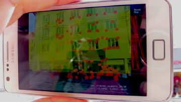
At VR, Ventura et al. present an approach to localize SLAM maps built on a mobile phone accurately wrt. a sparse 3D reconstruction of urban environments [72] (see Fig.18).
In April, Microsoft announces the acquisition of Nokia’s Devices and Services unit for $7.2 billion \citelinksMS14, as Nokia is the primary vendor for Windows devices devices, especially the Lumia phones.
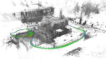
Following up on previous work at ICCV 2013 [14], at ECCV Engel et al. present LSD-SLAM, a feature-less monocular SLAM algorithm using keyframes and semi-dense depth maps, and release the code to the public [13] (see Fig.18). At ISMAR, a mobile version is presented as well [64].
At 3DV, Herrera et al. present DT-SLAM [24]. The key idea behind the approach is to defer the triangulation step of 2D features matched across keyframes until those have undergone a certain baseline, improving the overall robustness of SLAM.
At ISMAR, Salas-Moreno et al. present Dense Planar SLAM, leveraging the assumption that many man-made surfaces are planar [61].
2015
In January, Microsoft announces the Hololens, a headset to fuse AR and VR \citelinksMS15 to be made available later in 2015. The device is a complete computer with a see-through display and several sensors.
In May, DAQRI, a company working on AR helmets, acquires ARToolworks \citelinksART15. Oculus VR announced the acquisition of Surreal Vision, bringing the company’s expertise on recreating real-time 3D representations of the outside world into virtualized environments \citelinksOC15. A few days later, the acquisition of German AR company Metaio by Apple is announced \citelinksAP15. Metaio was a major player in distribution of AR technology to developers through their SDK, which ends abruptly now.
In June, Magic Leap announces that they will release its AR platform SDK to the public soon. It is expected to support Unity and the Unreal engine \citelinksML15.
HTC and Valve start shipping their developer hardware in very limited quantities \citelinksVA15, including a Vive headset and two Lighthouse base stations as passive components together with the two wireless Steam VR controllers.
In October 2015, Qualcomm sells its business unit in Vienna responsible for the development of the Augmented Reality SDK Vuforia to PTC \citelinksPT15 for 65 Mio. USD.
At ISMAR 2015, the group of Graz University of Technology wins the best paper award for their work ”Instant Outdoor Localization and SLAM Initialization from 2.5D Maps” [2]. The algorithm uses OpenStreetMap data and calculates the pose for an image based on building edges and semantic image information.
Acknowledgements
Thanks go to the ISMAR09 mobile committee and all others for their valuable suggestions.
References
- [1] Radio Telephone System, U.S. Patent Application U.S. 3,906,166, September 16, 1975.
- [2] C. Arth, C. Pirchheim, J. Ventura, D. Schmalstieg, and V. Lepetit, “Instant outdoor localization and SLAM initialization from 2.5d maps,” IEEE Trans. Vis. Comput. Graph., vol. 21, no. 11, pp. 1309–1318, 2015.
- [3] C. Arth, D. Wagner, M. Klopschitz, A. Irschara, and D. Schmalstieg, “Wide area localization on mobile phones,” in IEEE International Symposium on Mixed and Augmented Reality (ISMAR), pp. 73–82, IEEE, 2009.
- [4] R. T. Azuma, “A survey of augmented reality,” Presence: Teleoperators and Virtual Environments, vol. 6, pp. 355–385, August 1997.
- [5] B. B. Bederson, “Audio augmented reality: A prototype automated tour guide,” in Conference Companion on Human Factors in Computing Systems, CHI ’95, (New York, NY, USA), pp. 210–211, ACM, 1995.
- [6] B. Bell, S. Feiner, and T. Höllerer, “View management for virtual and augmented reality,” in Proceedings of the 14th Annual ACM Symposium on User Interface Software and Technology, UIST ’01, (New York, NY, USA), pp. 101–110, ACM, 2001.
- [7] O. Bergig, N. Hagbi, J. El-Sana, and M. Billinghurst, “In-place 3d sketching for authoring and augmenting mechanical systems,” in IEEE International Symposium on Mixed and Augmented Reality (ISMAR), pp. 87–94, 2009.
- [8] T. Caudell and D. Mizell, “Augmented reality: an application of heads-up display technology to manual manufacturing processes,” in System Sciences, 1992. Proceedings of the Twenty-Fifth Hawaii International Conference on, vol. ii, pp. 659–669 vol.2, Jan 1992.
- [9] A. D. Cheok, S. W. Fong, K. H. Goh, X. Yang, W. Liu, and F. Farzbiz, “Human pacman: A sensing-based mobile entertainment system with ubiquitous computing and tangible interaction,” in Proceedings of the 2Nd Workshop on Network and System Support for Games, NetGames ’03, (New York, NY, USA), pp. 106–117, ACM, 2003.
- [10] E. Coelho, S. Julier, and B. Maclntyre, “Osgar: a scene graph with uncertain transformations,” in IEEE International Symposium on Mixed and Augmented Reality (ISMAR), pp. 6–15, Nov 2004.
- [11] A. J. Davison, “Real-time simultaneous localisation and mapping with a single camera,” in 9th IEEE International Conference on Computer Vision (ICCV 2003), 14-17 October 2003, Nice, France, pp. 1403–1410, 2003.
- [12] S. DiVerdi and T. Hollerer, “Groundcam: A tracking modality for mobile mixed reality,” in IEEE Virtual Reality Conference (VR), pp. 75–82, March 2007.
- [13] J. Engel, T. Schöps, and D. Cremers, “LSD-SLAM: Large-scale direct monocular SLAM,” in European Conference on Computer Vision (ECCV), September 2014.
- [14] J. Engel, J. Sturm, and D. Cremers, “Semi-dense visual odometry for a monocular camera,” in IEEE International Conference on Computer Vision (ICCV), (Sydney, Australia), December 2013.
- [15] S. Feiner, B. MacIntyre, T. Höllerer, and A. Webster, “A touring machine: prototyping 3d mobile augmented reality systems for exploring the urban environment,” in IEEE International Symposium on Wearable Computers, pp. 74–81, Oct 1997.
- [16] G. W. Fitzmaurice, “Situated information spaces and spatially aware palmtop computers,” Commun. ACM, vol. 36, pp. 39–49, July 1993.
- [17] D. Fritsch, D. Klinec, and S. Volz, “Nexus — positioning and data management concepts for location-aware applications,” Computers, Environment and Urban Systems, vol. 25, no. 3, pp. 279 – 291, 2001.
- [18] J. Fruend, C. Geiger, M. Grafe, and B. Kleinjohann, “The augmented reality personal digital assistant,” in IEEE and ACM International Symposium on Augmented Reality (ISAR), 2001.
- [19] S. Gauglitz, C. Sweeney, J. Ventura, M. Turk, and T. Hollerer, “Live tracking and mapping from both general and rotation-only camera motion,” in IEEE International Symposium on Mixed and Augmented Reality (ISMAR), pp. 13–22, Nov 2012.
- [20] L. Gruber, S. Gauglitz, J. Ventura, S. Zollmann, M. Huber, M. Schlegel, G. Klinker, D. Schmalstieg, and T. Höllerer, “The city of sights: Design, construction, and measurement of an augmented reality stage set,” in IEEE International Symposium on Mixed and Augmented Reality (ISMAR), pp. 157–163, 2010.
- [21] J. Grubert, T. Langlotz, and R. Grasset, “Augmented reality browser survey,” Tech. Rep. 1101, Institute for Computer Graphics and Vision, Graz University of Technology, Graz, Austria, 2011.
- [22] S. Guven and S. Feiner, “Authoring 3d hypermedia for wearable augmented and virtual reality,” in IEEE International Symposium on Wearable Computers, pp. 118–126, Oct 2003.
- [23] A. Henrysson, M. Billinghurst, and M. Ollila, “Face to face collaborative ar on mobile phones,” in IEEE International Symposium on Mixed and Augmented Reality (ISMAR), pp. 80–89, Oct 2005.
- [24] D. Herrera C, K. Kim, J. Kannala, K. Pulli, and J. Heikkila, “Dt-slam: Deferred triangulation for robust slam,” in 3D Vision (3DV), 2014 2nd International Conference on, vol. 1, pp. 609–616, Dec 2014.
- [25] A. Hill, B. MacIntyre, M. Gandy, B. Davidson, and H. Rouzati, “Kharma: An open kml/html architecture for mobile augmented reality applications,” in Mixed and Augmented Reality (ISMAR), 2010 9th IEEE International Symposium on, pp. 233–234, Oct 2010.
- [26] T. Höllerer, S. Feiner, and J. Pavlik, “Situated documentaries: embedding multimedia presentations in the real world,” in IEEE International Symposium on Wearable Computers, pp. 79–86, Oct 1999.
- [27] T. Höllerer, S. Feiner, T. Terauchi, G. Rashid, and D. Hallaway, “Exploring MARS: developing indoor and outdoor user interfaces to a mobile augmented reality system,” Computers & Graphics, vol. 23, no. 6, pp. 779–785, 1999.
- [28] S. Julier, Y. Baillot, D. Brown, and M. Lanzagorta, “Information filtering for mobile augmented reality,” Computer Graphics and Applications, IEEE, vol. 22, pp. 12–15, Sep 2002.
- [29] S. Julier, Y. Baillot, M. Lanzagorta, D. Brown, and L. Rosenblum, “Bars: Battlefield augmented reality system,” in In NATO Symposium on Information Processing Techniques for Military Systems, pp. 9–11, 2000.
- [30] M. Kalkusch, T. Lidy, M. Knapp, G. Reitmayr, H. Kaufmann, and D. Schmalstieg, “Structured visual markers for indoor pathfinding,” in Augmented Reality Toolkit, The First IEEE International Workshop, pp. 8 pp.–, 2002.
- [31] H. Kato and M. Billinghurst, “Marker tracking and hmd calibration for a video-based augmented reality conferencing system,” in Augmented Reality, 1999. (IWAR ’99) Proceedings. 2nd IEEE and ACM International Workshop on, pp. 85–94, 1999.
- [32] A. C. Kay, “A personal computer for children of all ages,” August 1972.
- [33] G. Klein and D. Murray, “Parallel tracking and mapping for small ar workspaces,” in IEEE International Symposium on Mixed and Augmented Reality (ISMAR), (Washington, DC, USA), pp. 1–10, IEEE Computer Society, 2007.
- [34] G. Klein and D. Murray, “Parallel tracking and mapping on a camera phone,” in IEEE International Symposium on Mixed and Augmented Reality (ISMAR), (Orlando), IEEE Computer Society, October 2009.
- [35] R. Kooper and B. MacIntyre, “Browsing the real-world wide web: Maintaining awareness of virtual information in an ar information space.,” Int. J. Hum. Comput. Interaction, vol. 16, no. 3, pp. 425–446, 2003.
- [36] U. Kretschmer, V. Coors, U. Spierling, D. Grasbon, K. Schneider, I. Rojas, and R. Malaka, “Meeting the spirit of history,” in Proceedings of the 2001 Conference on Virtual Reality, Archeology, and Cultural Heritage, VAST ’01, (New York, NY, USA), pp. 141–152, ACM, 2001.
- [37] T. Langlotz, D. Wagner, A. Mulloni, and D. Schmalstieg, “Online creation of panoramic augmented reality annotations on mobile phones,” Pervasive Computing, IEEE, vol. 11, pp. 56–63, Feb 2012.
- [38] M. Li, B. H. Kim, and A. Mourikis, “Real-time motion tracking on a cellphone using inertial sensing and a rolling-shutter camera,” in Robotics and Automation (ICRA), 2013 IEEE International Conference on, pp. 4712–4719, May 2013.
- [39] J. M. Loomis, R. G. Golledge, and R. L. Klatzky, “Personal guidance system for the visually impaired using gps, gis, and vr technologies,” in Proceedings of the First Annual International Conference, Virtual Reality and Persons with Disabilities, pp. 71–74, June 1993.
- [40] A. Makri, D. Arsenijevic, J. Weidenhausen, P. Eschler, D. Stricker, O. Machui, C. Fernandes, S. Maria, G. Voss, and N. Ioannidis, “Ultra: An augmented reality system for handheld platforms, targeting industrial maintenance applications,” in Proceedings of 11th International Conference on Virtual Systems and Multimedia (VSMM’05), 2005.
- [41] P. Milgram and F. Kishino, “Taxonomy of mixed reality visual displays,” IEICE Transactions on Information and Systems, vol. E77-D, no. 12, pp. 1321 – 1329, 1994.
- [42] T. Miyashita, P. Meier, T. Tachikawa, S. Orlic, T. Eble, V. Scholz, A. Gapel, O. Gerl, S. Arnaudov, and S. Lieberknecht, “An augmented reality museum guide,” in IEEE International Symposium on Mixed and Augmented Reality (ISMAR), pp. 103–106, Sept 2008.
- [43] D. Mogilev, K. Kiyokawa, and M. Billinghurst, “Ar pad: An interface for face-to-face ar collaboration,” in In CHI 2002 Conference Proceedings, pp. 654–655, 2002.
- [44] M. Möhring, C. Lessig, and O. Bimber, “Video see-through ar on consumer cell-phones,” in IEEE International Symposium on Mixed and Augmented Reality (ISMAR), pp. 252–253, Nov 2004.
- [45] A. Morrison, A. Oulasvirta, P. Peltonen, S. Lemmela, G. Jacucci, G. Reitmayr, J. Näsänen, and A. Juustila, “Like bees around the hive: A comparative study of a mobile augmented reality map,” in Proceedings of the SIGCHI Conference on Human Factors in Computing Systems, CHI ’09, (New York, NY, USA), pp. 1889–1898, ACM, 2009.
- [46] L. Naimark and E. Foxlin, “Circular data matrix fiducial system and robust image processing for a wearable vision-inertial self-tracker,” in IEEE International Symposium on Mixed and Augmented Reality (ISMAR), pp. 27–36, 2002.
- [47] R. A. Newcombe, S. Izadi, O. Hilliges, D. Molyneaux, D. Kim, A. J. Davison, P. Kohli, J. Shotton, S. Hodges, and A. W. Fitzgibbon, “Kinectfusion: Real-time dense surface mapping and tracking,” in IEEE International Symposium on Mixed and Augmented Reality (ISMAR), pp. 127–136, 2011.
- [48] R. A. Newcombe, S. Lovegrove, and A. J. Davison, “DTAM: dense tracking and mapping in real-time,” in IEEE International Conference on Computer Vision (ICCV), pp. 2320–2327, 2011.
- [49] J. Newman, D. Ingram, and A. Hopper, “Augmented reality in a wide area sentient environment,” in IEEE and ACM International Symposium on Augmented Reality (ISAR), pp. 77–86, 2001.
- [50] Q. Pan, C. Arth, E. Rosten, G. Reitmayr, and T. Drummond, “Rapid scene reconstruction on mobile phones from panoramic images,” in IEEE International Symposium on Mixed and Augmented Reality (ISMAR), pp. 55–64, 2011.
- [51] C. Pirchheim and G. Reitmayr, “Homography-based planar mapping and tracking for mobile phones,” in IEEE International Symposium on Mixed and Augmented Reality (ISMAR), pp. 27–36, 2011.
- [52] C. Pirchheim, D. Schmalstieg, and G. Reitmayr, “Handling pure camera rotation in keyframe-based SLAM,” in IEEE International Symposium on Mixed and Augmented Reality (ISMAR), pp. 229–238, 2013.
- [53] R. Raskar, J. van Baar, P. Beardsley, T. Willwacher, S. Rao, and C. Forlines, “ilamps: Geometrically aware and self-configuring projectors,” in ACM SIGGRAPH 2003 Papers, SIGGRAPH ’03, (New York, NY, USA), pp. 809–818, ACM, 2003.
- [54] H. Regenbrecht and R. Specht, “A mobile passive augmented reality device - mpard,” in IEEE and ACM International Symposium on Augmented Reality (ISAR), pp. 81–84, 2000.
- [55] G. Reitmayr and D. Schmalstieg, “Mobile collaborative augmented reality,” in IEEE and ACM International Symposium on Augmented Reality (ISAR), pp. 114–123, 2001.
- [56] G. Reitmayr and T. Drummond, “Going out: robust model-based tracking for outdoor augmented reality,” in IEEE International Symposium on Mixed and Augmented Reality (ISMAR), pp. 109–118, Oct 2006.
- [57] J. Rekimoto, “Augmented reality using the 2d matrix code,” in Proceedings of the Workshop on Interactive Systems and Software (WISS’96), 1996.
- [58] J. Rekimoto and K. Nagao, “The world through the computer: Computer augmented interaction with real world environments,” in Proceedings of the 8th Annual ACM Symposium on User Interface and Software Technology, UIST ’95, (New York, NY, USA), pp. 29–36, ACM, 1995.
- [59] M. Rohs and B. Gfeller, “Using camera-equipped mobile phones for interacting with real-world objects,” in Advances in Pervasive Computing, pp. 265–271, 2004.
- [60] M. Rohs, J. Schöning, M. Raubal, G. Essl, and A. Krüger, “Map navigation with mobile devices: Virtual versus physical movement with and without visual context,” in Proceedings of the 9th International Conference on Multimodal Interfaces, ICMI ’07, (New York, NY, USA), pp. 146–153, ACM, 2007.
- [61] R. Salas-Moreno, B. Glocken, P. Kelly, and A. Davison, “Dense planar slam,” in IEEE International Symposium on Mixed and Augmented Reality (ISMAR), pp. 157–164, Sept 2014.
- [62] K. Satoh, M. Anabuki, H. Yamamoto, and H. Tamura, “A hybrid registration method for outdoor augmented reality,” in IEEE and ACM International Symposium on Augmented Reality (ISAR), vol. 29-30, pp. 67–76, Oct. 2001.
- [63] D. Schmalstieg, T. Langlotz, and M. Billinghurst, “Augmented reality 2.0,” in Virtual Realities (G. Brunnett, S. Coquillart, and G. Welch, eds.), pp. 13–37, Springer Vienna, 2011.
- [64] T. Schöps, J. Engel, and D. Cremers, “Semi-dense visual odometry for AR on a smartphone,” in IEEE International Symposium on Mixed and Augmented Reality (ISMAR), September 2014.
- [65] J. Spohrer, “Information in places,” IBM Systems Journal, vol. 38, no. 4, pp. 602–628, 1999.
- [66] T. Starner, S. Mann, B. J. Rhodes, J. Levine, J. Healey, D. Kirsch, R. W. Picard, and A. Pentland, “Augmented reality through wearable computing,” Presence, vol. 6, no. 4, pp. 386–398, 1997.
- [67] I. E. Sutherland, “A head-mounted three dimensional display,” in Proceedings of the December 9-11, 1968, Fall Joint Computer Conference, Part I, AFIPS ’68 (Fall, part I), (New York, NY, USA), pp. 757–764, ACM, 1968.
- [68] W. Tan, H. Liu, Z. Dong, G. Zhang, and H. Bao, “Robust monocular slam in dynamic environments,” in IEEE International Symposium on Mixed and Augmented Reality (ISMAR), pp. 209–218, Oct 2013.
- [69] P. Tanskanen, K. Kolev, L. Meier, F. Camposeco, O. Saurer, and M. Pollefeys, “Live metric 3d reconstruction on mobile phones,” in IEEE International Conference on Computer Vision (ICCV), pp. 65–72, Dec 2013.
- [70] B. Thomas, B. Close, J. Donoghue, J. Squires, P. De Bondi, M. Morris, and W. Piekarski, “Arquake: an outdoor/indoor augmented reality first person application,” in IEEE International Symposium on Wearable Computers, pp. 139–146, Oct 2000.
- [71] B. Thomas, V. Demczuk, W. Piekarski, D. Hepworth, and B. Gunther, “A wearable computer system with augmented reality to support terrestrial navigation,” in IEEE International Symposium on Wearable Computers, pp. 168–171, Oct 1998.
- [72] J. Ventura, C. Arth, G. Reitmayr, and D. Schmalstieg, “Global localization from monocular slam on a mobile phone,” in IEEE Virtual Reality, 03/2014 2014.
- [73] V. Vlahakis, J. Karigiannis, M. Tsotros, M. Gounaris, L. Almeida, D. Stricker, T. Gleue, I. T. Christou, R. Carlucci, and N. Ioannidis, “Archeoguide: First results of an augmented reality, mobile computing system in cultural heritage sites,” in Proceedings of the 2001 Conference on Virtual Reality, Archeology, and Cultural Heritage, VAST ’01, (New York, NY, USA), pp. 131–140, ACM, 2001.
- [74] D. Wagner, A. Mulloni, T. Langlotz, and D. Schmalstieg, “Real-time panoramic mapping and tracking on mobile phones,” in IEEE Virtual Reality Conference (VR), pp. 211–218, March 2010.
- [75] D. Wagner, T. Pintaric, F. Ledermann, and D. Schmalstieg, “Towards massively multi-user augmented reality on handheld devices,” in Pervasive Computing (H.-W. Gellersen, R. Want, and A. Schmidt, eds.), vol. 3468 of Lecture Notes in Computer Science, pp. 208–219, Springer Berlin Heidelberg, 2005.
- [76] D. Wagner, G. Reitmayr, A. Mulloni, T. Drummond, and D. Schmalstieg, “Pose tracking from natural features on mobile phones,” in IEEE International Symposium on Mixed and Augmented Reality (ISMAR), pp. 125–134, Sept 2008.
- [77] D. Wagner and D. Schmalstieg, “First steps towards handheld augmented reality,” in IEEE International Symposium on Wearable Computers, pp. 127–135, Oct 2003.
- [78] S. White and S. Feiner, “Sitelens: Situated visualization techniques for urban site visits,” in Proceedings of the SIGCHI Conference on Human Factors in Computing Systems, CHI ’09, (New York, NY, USA), pp. 1117–1120, ACM, 2009.
plain \bibliographylinkslinks