A Real-Time Spatial Index for In-Vehicle Units
Abstract
We construct a spatial indexing solution for the highly constrained environment of an in-vehicle unit in a distributed vehicle tolling scheme based on satellite navigation (gnss). We show that a purely functional implementation of a high-fanout quadtree is a simple, practical solution that satisfies all the requirements of such a system.
Introduction
Open road tolling is an increasingly common phenomenon, with transponder-based tolling proposed as early as in 1959 [1], and a wide variety of more complex technologies emerging over the recent decades [2]. One of the more recent developments is the use of satellite navigation (gnss), with geographical points and zones determining the pricing [see, e.g., 3]. In this paper, we examine the feasibility of maintaining a geographical database in an in-vehicle unit, which can perform many of the tasks of such a location-based system independently.
This is a proof-of-concept application paper. Our main contributions can be summed up as follows: (i) We specify a set of requirements for a spatial database to be used in the highly constrained environment of a real-time, low-cost in-vehicle unit in Section 2 (ii) we construct a simple data structure that satisfies these requirements in Section 3 (iii) we tentatively establish the feasibility of the solution through an experimental evaluation in Section 4. In the interest of brevity, some technical details have been omitted. See the report by Lykkja [4] for more information.
The Problem: Highly Constrained Spatial Indexing
The basic functionality of our system is to retrieve relevant geographic (i.e., geometric) objects, that is, the tolling zones and virtual toll gantries that are within a certain distance of the vehicle. Given the real-time requirements and the limited speed of the available hardware, a plain linear scan of the data would be infeasible even with about 50 objects. A real map of zones and gantries would hold orders of magnitude more objects than that (c.f., Table 3). This calls for some kind of geometric or spatial indexing [5], although the context places some heavy constraints on the data structure used. One fundamental consideration is the complexity of the solution. In order to reduce the probability of errors, a simple data structure would be preferable. Beyond simplicity, and the need for high responsiveness, we have a rather non-standard hardware architecture to contend with.
The memory of the on-board unit is assumed to be primarily flash memory with serial access. The scenario is similar to that of a desktop computer, where the index would be stored on a hard drive, with a subset in RAM and the L2 cache. For an overview of the hierarchical nature of the memory architecture, see Figs. 1 and 1. The serial nature of the memory forces us to read and write single bits at a time in a page. A read operation takes . A write operation takes , and may only alter a bit value of 1 to a bit value of 0. A sector, subsector or page may be erased in a single operation, filling it with 1-bits in approximately . One important constraint is also that each page may typically only be erased a limited number of times (about ), so it is crucial that our solution use the pages cyclically, rather than simply modifying the current ones in-place, to ensure wear leveling.
| Description | Size | Access time | Persistent? |
|---|---|---|---|
| Processor internal memory | -bytes | Zero wait state | No |
| External RAM | Non-zero wait states | No | |
| Serial Flash | 8, 16 or | See main text | Yes |
Based on general needs of a self-contained tolling system, and on the hardware capabilities just described, we derive the following set of requirements:
-
A.
The system must accommodate multiple versions of the same index structure at one time. The information may officially change at a given date, but the relevant data must be distributed to the units ahead of time.
-
B.
It must be possible to distribute new versions as incremental updates, rather than a full replacement. This is crucial in order to reduce communication costs and data transfer times. It will also make it less problematic to apply minor corrections to the database.
-
C.
The memory footprint must be low, as the memory available is highly limited.
-
D.
The database must maintain integrity, even during updates, to ensure uninterrupted access. It must be possible to roll back failed updates without affecting the current database.
-
E.
The indexing structure must be efficient in terms of CPU cycles during typical operations. Both available processing time and energy is highly limited and must not be wasted on, say, a linear scan over the data.
-
F.
The relevant data structure must minimize the number of flash page reads needed to perform typical operations, especially for search. Flash-page reads will be a limiting factor for some operations, so this is necessary to meet the real-time operation requirements.
-
G.
In order to avoid overloading individual pages (see discussion of memory architecture, above), wear leveling must be ensured through cyclic use.
-
H.
The typical operations that must be available under these constraints are basic two-dimensional geometric queries (finding nearby points or zones) as well as modification by adding and removing objects.
In addition, the system must accommodate multiple independent databases, such as tolling information for adjacent countries. Such databases can be downloaded on demand (e.g., when within a given distance of a border), cached, and deleted on a least-recently-used basis, for example. We do not address this directly as a requirement, as it is covered by the need for a low memory footprint per database (Req. C).
As in most substantial lists of requirements, there are obvious synergies between some (e.g., Reqs. E and F) while some are orthogonal and some seem to be in direct opposition to each other (e.g., Reqs. A and C). In Section 3, we describe a simple index structure that allows us to satisfy all our requirements to a satisfactory degree.
Our Solution: Immutable 9-by-9 Quadtrees
The solution to the indexing problem lies in combining two well-known technologies: quadtrees and immutable data structures.
In the field of geographic and geometric databases, one of the simplest and most well-known data structures is the quadtree, which is a two-dimensional extension of the basic binary search tree. Just as a binary search tree partitions into two halves, recursively, the quadtree partitions into quadrants. A difference between the two is that where the binary search tree splits based on keys in the data set, the quadtree computes its quadrants from the geometry of the space itself.111Technically, this is the form of quadtrees known as PR Quadtrees [5, § 1.4.2.2]. In order to reduce the number of node (i.e., page) accesses, at the expense of more coordinate computations, we increase the grid of our tree from 2-by-2 to 9-by-9. The specific choice of this grid size is motivated by the constraints of the system. We need 3 bytes to address a flash page and with a 9-by-9 grid, we can fit one node into bytes, which permits us to fit one node (along with some book-keeping data) into a flash page. This gives us a very shallow tree, with a fanout of 81, which reduces the number of flash page accesses considerably. For an example of the resulting node sizes (area of ground covered), see Table 2. The last three columns show the number of leaf nodes at the various levels in the experimental build described in Section 4.
| Level | Size | Zone | VG | Both |
|---|---|---|---|---|
| Top | m | |||
| 1 | m | |||
| 2 | m | |||
| 3 | m | |||
| 4 | m | |||
| 5 | m |
Immutable data structures have been used in purely functional programming for decades [see, e.g., 6], and they have recently become more well known to the mainstream programming community through the data model used in, for example, the Git version control system [see, e.g., 7, p. 3]. The main idea is that instead of modifying a data structure in place, any nodes that would be affected by the modification are duplicated. For a tree structure, this generally means the ancestor nodes of the one that is, say, added. Consider the example in Fig. 2. In Fig. 2(a), we see a tree consisting of nodes through , and we are about to insert . Rather than adding a child to , which is not permitted, we duplicate the path up to the root, with the duplicated nodes getting the appropriate child-pointers, as shown in Fig. 2(b), where the duplicated nodes are highlighted. As can be seen, the old nodes (dotted) are still there, and if we treat the old as the root, we still have access to the entire previous version of the tree.
Experimental Evaluation
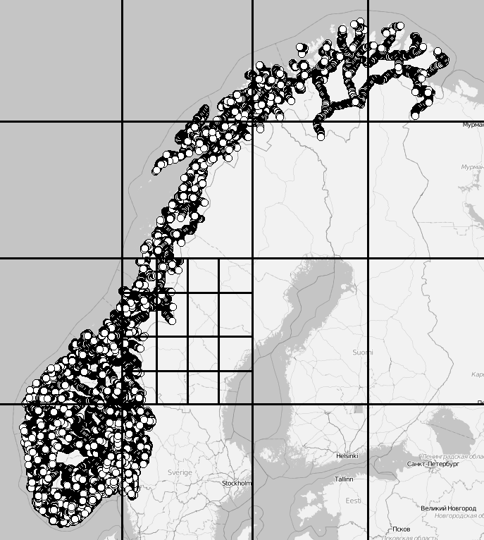
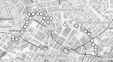
Our experiments were performed with a data set of approximately virtual gantries (see Fig. 3(a)), generated from publicly available maps [8]. The maps describe the main roads of Norway with limited accuracy. Additionally, more detailed and accurate virtual gantries were created manually for some locations in Oslo and Trondheim. Fig. 4(a) shows the relevant virtual gantries in downtown Oslo, used in our test drive. There are about 35 virtual gantries on this route, and many of these are very close together. In general, there is one virtual gantry before every intersection.


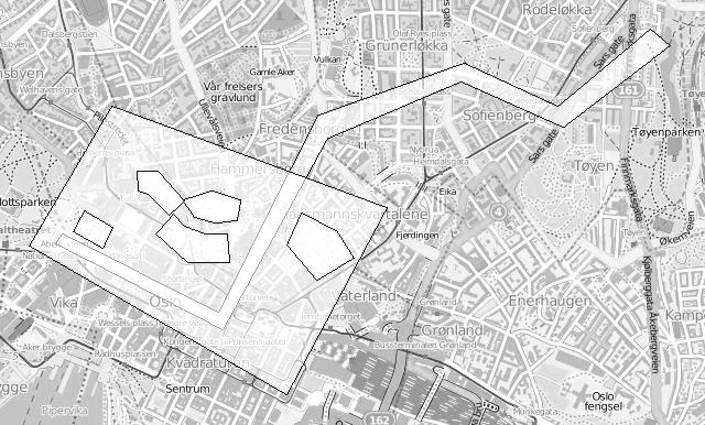
Each local administrative unit (kommune) is present in the maps used [8], with fairly accurate and detailed boundaries. There are such zones in total (see Fig. 3(b)). In addition, more detailed and accurate zones were created manually for some locations in the cities of Oslo and Trondheim. Some of these are quite small, very close together, and partially overlapping (see Fig. 4(b)).
Data Structure Build
These test data were inserted into the quadtree as described in Section 3. Table 3 summarizes the important statistics of the resulting structure. The numbers for memory usage are also shown in Fig. 5, for easier comparison.
| Description | Zones | VGs | Both | |
|---|---|---|---|---|
| a | Number of objects in database | |||
| b | Flash pages for index and data | |||
| c | Size () | |||
| d | Flash pages for index | |||
| e | Objects referenced by leafs | |||
| f | Leaf nodes per object | |||
| g | Leaf entries not used, empty | |||
| h | Leaf entries set | |||
| i | Max index tree depth | |||
| j | Zone inside entries | |||
| k | Zone edge entries | |||
| l | Distinct leaf pages | |||
| m | Total leaf pages | |||
| n | Duplicate leaf pages | |||
| o | Flash pages, dups removed | |||
| p | Size, dups removed () | |||
| q | Index pages, dups removed | |||
| r | Size of index, dups removed () |
Judging from these numbers (row r), a database containing only zones would be quite small (about ). Each zone is referenced by leaf nodes on average (row f). Also note that only leaf nodes (squares) are entirely contained in a zone (row j). This implies that the geometric inside/outside calculations will need to be computed in most cases.
This can be contrasted with the combined database of gantries and zones. The index is larger (, row r), but the performance of polygon assessments is much better. Each polygon is referenced from leaf nodes (row f) and there are more inside entries than edge entries ( vs ). This indicates that the geometric computations will be needed much less frequently.
Each of the three scenarios creates a number of duplicate leaf pages. Many leaf pages will contain the same zone edge/inside information. In our implementation of the algorithm, this issue is not addressed or optimized. It is, however, quite easy to introduce a reference-counting scheme or the like to eliminate duplicates, in this scenario saving (as shown in rows o through r).
The zone database contains very few empty leaf entries (row g), because the union of the regions covers the entire country, with empty regions found in the sea or in neighboring countries.
Flash Access in a Real-World Scenario
The index was also tested in a drive, eastbound on Ibsenringen, in downtown Oslo. The relevant virtual gantries are shown in the map in Fig. 4(a). The in-memory flash cache used was 15 pages (), and the cache was invalidated before test start. Fig. 6 shows the result, in terms of flash accesses and the number of gantries found.

Discussion
To view our results in the context of the initial problem, we revisit our requirement list from Section 2. We can break our solution into three main features: (i) The use of quadtrees for indexing (ii) purely functional updates and immutability (iii) high fanout, with a 9-by-9 grid. Table 4 summarizes how these features, taken together, satisfy all our requirements. Each feature is either partly or fully relevant for any requirement it helps satisfy (indicated by or , respectively).
Our starting-point is the need for spatial (two-dimensional) indexing (Req. H), and a desire for simplicity in our solution. The slowness of our hardware made a straightforward linear scan impossible, even with a data set of limited size. This led us to the use of quadtrees, whose primary function, seen in isolation, is satisfying Req. E, CPU efficiency. It also supports Req. C (low memory footprint) by giving us a platform for reducing duplication. Lastly, it supports efficiency in terms of flash page accesses (Req. F), which is primarily handled by high fanout, using the nine-by-nine grid.
The purely functional updates, and the immutable nature of our structure, satisfies a slew of requirements by itself. Just as in modern version control systems such as Git [7], immutable tree structures where subtrees are shared between versions gives us a highly space-efficient way of distributing and storing multiple, incremental versions of the database (Reqs. A, B and C). This also gives us the ability to keep using the database during an update, and to roll back the update if an error occurs, without any impact on the database use, as the original database is not modified (Req. D). Finally, because modifications will always use new flash pages, we avoid excessive modifiations of, say, the root node, and can schedule the list of free nodes to attain a high degree of wear leveling (Req. G).
In our tests, as discussed in the previous section, we found that the solution satisfied our requirements not only conceptually, but also in actual operation. It can contain real-world data within real-world memory constraints (Table 3), and can serve up results in real time during actual operation, with relatively low flash access rates (Fig. 6).
| Feature | A | B | C | D | E | F | G | H |
|---|---|---|---|---|---|---|---|---|
| The use of quadtrees for indexing | ||||||||
| Purely functional updates and immutability | ||||||||
| High fanout, with 9-by-9 grid |
Conclusion & Future Work
We have described the problem of real-time spatial indexing in an in-vehicle satellite navigation (gnss) unit for the purposes of open-road tolling. From this problem we have elaborated a set of performance and functionality requirements. These requirements include issues that are not commonly found in indexing for ordinary computers, such as the need for wear-leveling over memory locations. By modifying the widely used quadtree data structure to use a higher fanout, and by making it immutable, using purely functional updates, we were able to satisfy our entire list of requirements. We also tested the solution empirically, on real-world data and in a real-world context of a vehicle run, and found that it performed satisfactorily.
Although our object of focus has been a rather limited family of hardware architectures, the simple, basic ideas of our index chould be useful also for other devices and applications where real-time spatial indexing is required under somewhat similar flash memory conditions. Possible extensions of our work could be to test the method under different conditions, perhaps by developing a simulator for in-vehicle units with different architectures and parameters. This could be useful for choosing among different hardware solutions, as well as for tuning the index structure and database.
Disclaimer & Acknowledgements
Magnus Lie Hetland introduced the main design idea of using immutable, high-fanout quadtrees for the database structure. He wrote the majority of the text of the current paper, based in large part on the technical report of Lykkja [4]. Ola Martin Lykkja implemented and benchmarked the database structure and documented the experiments [4]. Neither author declares any conflicts of interest. Both authors have revised the paper and approved the final version. The authors would like to thank Hans Christian Bolstad for fruitful discussions on the topic of the paper. This work has in part been financed by the Norwegian Research Council (BIA project no. 210545, “SAVE”).
References
- Kelly [2006] Frank Kelly. Road pricing: addressing congestion, pollution and the financing of britain’s roads. Ingenia, 29:34–40, December 2006.
- Hills and Blythe [2002] Peter Hills and Phil Blythe. For whom the road tolls? Ingenia, 14:21–28, November 2002.
- Grush [2008] Bern Grush. Road tolling isn’t navigation. European Journal of Navigation, 6(1), February 2008.
- Lykkja [2012] Ola Martin Lykkja. SAVE tolling objects database design. Technical Report QFR01-207-1492 0.7, Q-Free ASA, Trondheim, Norway, 2012.
- Samet [2006] Hanan Samet. Foundations of Multidimensional and Metric Data Structures. Morgan Kaufmann, 2006.
- Okasaki [1999] Chris Okasaki. Purely Functional Data Structures. Cambridge University Press, 1999.
- Loeliger and McCullough [2012] Jon Loeliger and Matthew McCullough. Version Control with Git. O’Reilly, second edition, 2012.
- Kartverket [2012] Kartverket. N2000 kartdata. Available from http://www.kartverket.no/Kart/Kartdata/Vektorkart/N2000, 2012.