Vol.0 (200x) No.0, 000–000
22institutetext: University of Chinese Academy of Sciences, Beijing 100049, China
The Principle of Navigation Constellation Composed of SIGSO Communication Satellites
Abstract
The Chinese Area Positioning System (CAPS), a navigation system based on GEO communication satellites, was developed in 2002 by astronomers at Chinese Academy of Sciences. Extensive positioning experiments of CAPS have been performed since 2005. On the basis of CAPS, this paper studies the principle of navigation constellation composed of Slightly Inclined Geostationary Orbit (SIGSO) communication satellites. SIGSO satellites are derived from end-of-life Geostationary Orbit (GEO) satellites under inclined orbit operation. Considering the abundant frequency resources of SIGSO satellites, multi-frequency observations could be conducted to enhance the precision of pseudorange measurements and ameliorate the positioning performence. The constellation composed of two GEO satellites and four SIGSO satellites with inclination of 5∘ can provide the most territory of China with 24-hour maximum PDOP less than 42. With synthetic utilization of the truncated precise (TP) code and physical augmentation factor in four frequencies, navigation system with this constellation is expected to obtain comparable positioning performance with that of coarse acquisition code of GPS. When the new approach of code-carrier phase combinations is adopted, the system has potential to possess commensurate accuracy of precise code in GPS. Additionally, the copious frequency resources can also be used to develop new anti-interference techniques and integrate navigation and communication.
keywords:
astrometry and celestial mechanics — astronomy application — artificial satellite — satellite navigation constellation1 Introduction
The GPS of America and the GLONASS of Russia could provide Position, Velocity and Time (PVT) services for users with global coverage and all-weather capacity. Chinese Compass has been extending its coverage and is scheduled to be a global satellite navigation system around 2020111http://en.wikipedia.org/wiki/Beidou_navigation_system. European Galileo is in the initial phase at present and will launch positioning applications on a global scale as early as 2020222http://en.wikipedia.org/wiki/Galileo_%28satellite_navigation%29. Several regional navigation systems have also emerged recently, such as the Quasi-Zenith Satellite System (QZSS) of Japan, the Indian Regional Navigational Satellite System (IRNSS). All of the above GPS-like systems require the launch of specific navigation satellites to constitute constellations. In 2002, a group of astronomers at Chinese Academy of Sciences (CAS) presented a new concept of navigation, to constitute an positioning system using Geostationary Orbit (GEO) communication satellites333National Astronomical Observatories of China, CAS, National Time Service Center, CAS, Transponder satellite com-munication navigation and positioning system, Ai, G. X., Shi, H. L., et al. PRC Patent, No. 200410046064.1, 2004, which is fundamentally different from the GPS-like systems in that navigation signals are generated on the ground station and then transmitted by transponders on communication satellites, while receivers decode the signals and achieve positioning, measurements of velocity and time, and communication.
Under the guidance of this pioneering idea, researchers organized by CAS successfully developed the Chinese Area Positioning System (CAPS). Comparing with the GPS-like systems, some advantages are introduced in CAPS: (1) the cost is much lower and the deployment cycle is notably shorter by resorting to available GEO satellites instead of launching specific navigation satellites; (b) a more accurate and reliable atomic clock can be employed to provide time reference as navigation signals are generated on the ground; (3) inherent communication functions of GEO satellites can be embedded in navigation applications to realize the integration of navigation and communication (Ai et al. 2008; Ai et al. 2009b ; Shi et al. 2009a ; Li & Dempster 2010; Ma et al. 2012). In 2005, demonstration system of CAPS was tested in six cities of China, which successfully passed acceptance and adequately displayed the features of CAPS. CAPS was then included in the guidelines on national medium- and long-term program for science and technology development (2006-2020) as an important part of the Chinese second generation satellite navigation system. Subsequent to the successful development of CAPS, the Boeing Company began to make use of the Iridium communication system to enhance GPS and carry out navigation-related applications in 2007444http://www.coherentnavigation.com/press/2007.04.11_ee_times.pdf. The Iridium system consists of 66 operational satellites positioned in six Sun-synchronous orbital planes. It works in L-band for voice data communications and offers much stronger ground receiving signals to users than GPS does because of its low-orbit satellites. These features enable the Iridium system to further GPS.
The constellation with only GEO satellites cannot provide three-dimensional (3D) positioning because the satellites are located in coplanar orbit over the equator. In CAPS demonstration system, GEO satellites and specific barometric altimeter were combined to realize altitude-aiding 3D positioning (Ai et al. 2009a ). In this paper, Slightly Inclined Geostationary Orbit (SIGSO) satellites are recommended to be deployed in navigation system, which could qualify the system to attain independent 3D positioning. Owing to various perturbations, orbit elements of GEO satellite vary constantly (Zhang 1998; Ma et al. 2011b ). Orbital position of the operational GEO satellite should be maintained at certain precision. When a GEO satellite approaches the end of its life, inclined orbit operation is implemented to save propellant fuel and prolong its service life, which means the fuel is only consumed for east-west station-keeping and attitude control. Under inclined orbit operation, the end-of-life GEO satellite in effect becomes a SIGSO satellite555http://www.satsig.net/satellite/inclined-orbit-operation.htm. SIGSO satellites have radical improvements on geometric configuration of navigation constellation by introducing north-south components and further enable the navigation system to offer 3D positioning services. Furthermore, by exploiting plentiful frequency resources of SIGSO satellites, positioning with high performance could be acquired, as well as the new anti-interference techniques and integration of navigation and communication (Shi et al. 2009; Han et al. 2009; Cui et al. 2009; Ma et al. 2011).
The principle of constituting navigation constellation employing SIGSO communication satellites is studied in this paper. Perturbations and SIGSO communication satellites are introduced in Section 2. We establish observation equations for the system based on communication satellites and perform analyses of Position Dilution of Precision (PDOP) values in Section 3. Section 4 gives an overview of the navigation performance. Finally, several issues are further investigated pertaining to the navigation system based SIGSO satellites.
2 PERTURBATIONS AND SIGSO COMMUNICATION SATELLITES
2.1 Perturbations
The GEO satellite is subject to various perturbing forces, mainly comprising the Earth nonspherical gravity, lunisolar gravitational force and solar radiation pressure. Due to the perturbations, motions of the satellite no longer follow the two-body dynamic equations and its inclination, orbital period, eccentricity and Right Ascension of the Ascending Node (RAAN) constantly change (Zhang 1998; Ma et al. 2011b ).
Mass distribution of the Earth is uneven and its shape is also irregular. The polar radius is approximately 23 kilometers shorter than the equatorial radius. The equatorial plane shows slight oval shape (difference between semi-major axis and semi-minor axis is about 68 meters). The GEO satellite consequently gravitates both in tangent and normal directions of the orbit, and the magnitude depends on the satellite’s position and distance from the Earth. The longitudes of the minor axis of the equator are at about 75∘E and 105∘W, which have a difference of 90∘ with that of major axis. The Earth’s equatorial ellipticity has a long-term accelerating effect on longitude of the sub-satellite point. As points of minor axis are stable and points of major axis are instable in geostationary orbit, the equatorial ellipticity produces perturbations which cause the satellite to drift back and forth in east-west direction around the points of minor axis.
As revolution of the Earth is in ecliptic plane, movements of GEO satellite relate not only to gravity acted upon the satellite by the Earth, the Sun and the Moon, but also to gravity imposed on the Earth by the Sun and the Moon. Lunisolar gravitational force is the most important factor causing the change of inclination. Because the lunar orbit has an angle between 23.5∘ 5.1∘ relative to the equatorial plane, the drift of satellite’s inclination varies every year and its value depends on the average value of the lunar orbit’s inclination in a period of 18.6 years. The annual drift rate is from 0.75∘ to 0.95∘, and its direction alters in different years as the lunar orbit pole changes. Since SIGSO satellite has no station-keeping in north-south direction, the satellite’s orbit rotates with a 52-year cycle, centering on a pole which has an angle of 7.5∘ with respect to the terrestrial pole. If initial inclination of a SIGSO satellite is 0∘, the inclination will reach the maximum value of about 15∘ after 26 years and then decrease annually.
The GEO satellite is also exposed to the Sun radiation. One part of the radiation is absorbed and the other part is reflected. The conversion of energy involved is known as solar radiation pressure which is the largest non-gravitational perturbation for the satellite, and hence can have a significant influence on its orbital dynamics. Solar radiation pressure mainly affects orbital eccentricity. The movement of eccentricity vector relies on area-mass ratio of the satellite and the endpoint of the vector forms an ellipse with a period of one year.
2.2 SIGSO Communication Satellites
Because of the above perturbations, the GEO communication satellite drifts ceaselessly. Operational GEO satellite must be kept in a control box in order to meet the requirements of anti-interference and isolation with adjacent communication satellites. The GEO satellite therefore always carries propellant fuel which is consumed to conduct attitude control, and produce east-west velocity increment against the nonspherical gravity and the solar radiation pressure, as well as north-south velocity increment against lunisolar perturbation.
Most of the fuel on a GEO communication satellite is expended to maneuver its position against disturbances in north-south direction. As each satellite carries a restricted quantity of the fuel, the satellite will come close to the end of its life after some years in operation. Generally the design life has certain redundancy, so solar battery and signal transponders in end-of-life GEO satellite can still serve several years. When attitude control and east-west maneuvering of an end-of-life GEO satellite are still maintained, the satellite in fact becomes a SIGSO satellite. Since the fuel is no longer used for maintaining the orbital position in north-south direction but only little portion needed for east-west station-keeping and attitude control, the remaining lifetime of a SIGSO satellite can be extended largely before being placed into graveyard orbit (Shi et al. 2009; Li & Dempster 2010; Ma 2011). This technique of maneuvering end-of-life GEO satellites to SIGSO satellites is known as inclined orbit operation.
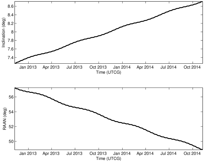
Evolution of inclination and RAAN of a certain SIGSO satellite is illustrated in Figure 1. Further studies reveal that phase differences (time differences passing the equatorial plane) of two SIGSO satellites are determined by their differences in RAAN and differences in longitude of the sub-satellite point (Jing & Zhang 2009). Seeing that SIGSO satellites follow the same evolution of inclination and RAAN, the phase differences are mainly determined by the differences in longitude of the sub-satellite point.
2.3 Advantages and Applications of SIGSO Communication Satellites
The cost of renting or purchasing end-of-life GEO satellites and then maneuvering them into SIGSO satellites is obviously lower than that of developing and launching specific satellites. By deploying SIGSO satellites in navigation constellation, one can reduce the period and the expense of constructing navigation system, and make communication satellites play an important role in navigation and communication applications. As SIGSO satellites have “figure-8” ground tracks and accordingly can effectively improve the geometric configuration by introducing north-south components, navigation system deploying a certain number of SIGSO satellites can provide 3D positioning services.
Attributable to the plentiful frequency resources of SIGSO satellites, multi-frequency observations can be performed to achieve centimeter-precision pseudorange measurement and augment positioning accuracy. Since there are transponders covering almost whole C band on SIGSO satellites, frequency-switching techniques can be carried out to reinforce anti-interference performance. Because each SIGSO communication satellite has frequency band up to 300 MHz or more, information transmission service based on position, time and status can be provided aside from positioning service. In addition, SIGSO satellites can preserve the precious GEO resources (Shi et al. 2009).
3 3. OBSERVATION EQUATIONS AND PDOP ANALYSES FOR THE CONSTELLATION BASED ON SIGSO COMMUNICAITON SATELLITES
3.1 Observation Equations
In navigation system based on communication satellites, navigation signals are generated on the ground station and transmitted via satellite transponders to users. Using the virtual clock technique, generation time of navigation signals can be delayed into transmission time at satellite antenna phase center (Li et al. 2009a ). To obtain three positions and clock bias, at least four satellites should be simultaneously observed by users. Pseudorange observation equation based on code phase from the th satellite can be modeled as
| (1) |
where , and is the number of observed satellites; denotes the pseudorange from antenna phase center on the ground station to antenna phase center of the receiver; is the geometric distance between the receiver antenna phase center at signal reception time and the satellite antenna phase center at signal transmission time; and are the ionospheric and tropospheric propagation delays, respectively; is the speed of light; is receiver clock offset; stands for the virtual clock parameter, which is broadcasted in the navigation messages; and account for multipath effects and measured errors, respectively. We denoteby the pseudorange obtained after modifying the virtual clock and propagation delays and compensating for the multipath effects in the measurements. Equation (1) is then rewritten as
| (2) |
To characterize the quality of the positioning estimates, model for the measurement error in Equation (2) is simplified as (Misra & Enge 2006)
| (3) |
where represents the mean value, denotes covariance, is the identity matrix, and is the common standard deviation of the user range error for each visible satellites. Let and denote the estimates of positions and clock bias in the local east-north-up (ENU) coordinate frame respectively, the covariance matrix can been written as
| (4) |
where ; is matrix with each row composed of three elements of direction cosine vector represented in ENU coordinate frame, and an entry of 1 in the last column. The Dilution of Precision (DOP) parameters are defined as (Misra & Enge 2006)
| (5a) | |||
| (5b) | |||
| (5c) | |||
| (5d) | |||
| (5e) | |||
The DOP parameters provide simple characterization of the user-satellite geometry. The positioning error mainly depends upon the measurement geometry and pseudorange measurement error. The quality of the estimates can be described as (Kaplan & Hegarty 2006)
| (6) |
where designates GDOP, PDOP, HDOP, VDOP or TDOP; is the corresponding estimation errors. It is more common to investigate the PDOP distributions for the quality of 3D position estimates generally receives extra attentions from users.
3.2 PDOP Analyses
Considering that the navigation coverage of the constellation based on SIGSO satellites has a north-south symmetry, territories of China are taken for instance to investigate the constellation configuration. Ten cities in China, which could be considered as several of representative stations in geographical distribution, are then selected to analyze PDOP distributions. Daily PDOP distributions in the ten cities are computed using two GEO satellites situated in 87.5∘E and 110.5∘E and four SIGSO satellites situated in 59∘E, 71.7∘E, 125∘E and 142∘E respectively. All the six satellites are controlled by stations within the mainland of China. In the simulation, we presume that navigation signals can be continuously uplinked to these communication satellites. Inclination of the four SIGSO satellites is assumed to be 5∘ and elevation mask angle is 10∘. The PDOP values are computed one minute apart over a 24-hour period and presented in Table 1 .
| City | Latitude | Longitude | PDOP | ||
|---|---|---|---|---|---|
| max | min | mean | |||
| Beijing | 39.90∘N | 116.47∘E | 38.3 | 15.3 | 23.1 |
| Shanghai | 31.20∘N | 121.43∘E | 37.7 | 15.2 | 22.7 |
| Changchun | 43.89∘N | 125.31∘E | 40.9 | 15.5 | 24.7 |
| Taipei | 25.05∘N | 121.51∘E | 37.3 | 15.1 | 22.5 |
| Sanya | 18.20∘N | 109.50∘E | 36.5 | 14.9 | 22.1 |
| Kunming | 25.05∘N | 102.70∘E | 36.8 | 14.9 | 22.3 |
| Lhasa | 29.66∘N | 91.13∘E | 37.1 | 15.1 | 22.6 |
| Kashgar | 39.45∘N | 75.98∘E | 41.3 | 15.5 | 25.6 |
| Urumchi | 43.77∘N | 87.60∘E | 38.4 | 15.5 | 23.3 |
| Xi’an | 34.25∘N | 108.92∘E | 37.6 | 15.2 | 22.7 |
To give a comparision with GPS, the daily distributions of PDOP for the constellation of the six satellites and the constellation of GPS in Beijing, Taipei, Kunming and Kashgar are shown in Figure 2.
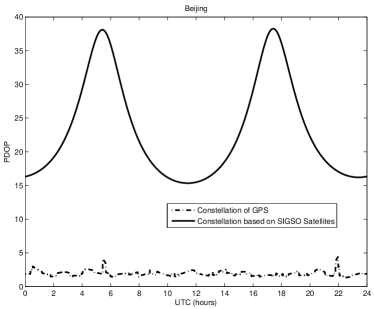
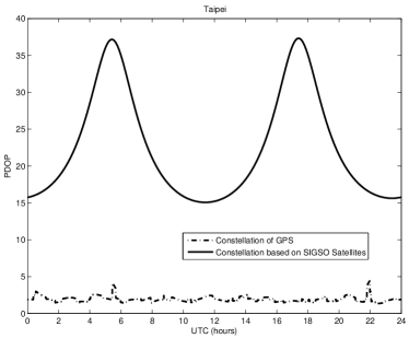
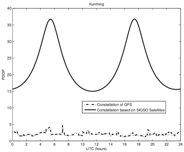
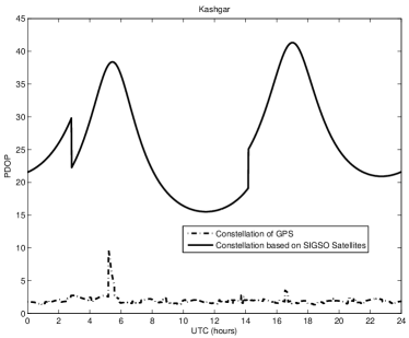
It can be noted from Table 1 that the maximum PDOP value over 24 hours for all of the stations is below 42. Moreover, the PDOP values will get better and better because inclination angles of the SIGSO satellites increase constantly as time goes on.
4 AN OVERVIEW OF POSITIONING PERFORMANCE
4.1 Multi-frequency observations
Considering the profuse frequency resources of SIGSO communication satellites, Ai et al. 2011 proposed a new approach of code-carrier phase combinations. In the new approach, three frequencies are selected to structure linear combinations of code phase and carrier phase. As “Positive” linear combination and “Negative” linear combination both have ionospheric terms with approximately same magnitude and opposite sign, integer ambiguity can be fast fixed, and ionospheric delays can be quickly corrected due to their large differences between the two selected carrier phase combinations (Ai et al. 2011). The new approach of code-carrier phase combinations possesses the high dynamics of code phase measurements as well as the high precision of carrier phase measurements. To further take advantage of the plentiful frequency resources of SIGSO satellites, navigation signals are transmitted at multiple frequencies from each satellite and users independently measure the corresponding multiple pseudoranges, which could enhance the positioning accuracy significantly. This method is referred to as Physical Augmentation Factor of Precision (PAFP)666National Astronomical observatories, CAS, A method of improving positioning precision in satellite navigation systems, Ai, G. X., Ma, L. H., Shi, H. L., Ji, H. F., PRC Patent, No. 201210090864.8, 2012 (Ai et al. 2012).
4.2 Performance evaluation
The above analyses suggest that positioning accuracy rests with precision factor (geometric DOP and physical PAFP) and pseudorange measurement accuracy.
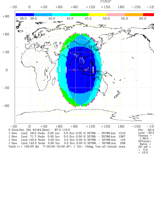
The global distribution of 24-hour maximum PDOP value for the constellation with the prior six satellites is illustrated in Figure 3. As for China, more than 95 percent of the area can gain a maximum PDOP value smaller than 42 over 24 hours. The constellation provides 92 percent of the area with the average PDOP value below 25. The minimum PDOP value in 95 percent of the area is less than 16.
The combined effect of error sources on pseudorange measurements is referred to as the user equivalent range error (UERE). It is reasonable to model these errors due to the satellite clock end ephemeris, atmospheric propagation, multipath, and receiver noise to be uncorrelated, and then the UERE can be defined as the root-sum-square of these components (Misra & Enge 2006). In transmitted orbit determination method, an accuracy of about 1.0 m of orbit determination could be obtained (Li et al. 2009a ; Li et al. 2009b ). As the first-order ionospheric effect is inversely proportional to the square of the carrier frequency, the ionospheric effect in the C-band navigation system based on SIGSO satellites is much less than in GPS. For tropospheric correction, it is suggested to establish observation stations on grid points over a large area to collect atmospheric pressure, temperature and humidity. These actual atmospheric parameters collected could be used to construct a time-changeable tropospheric delay model (Ai et al. 2011). The rms residual error attributed to atmospheric propagation models is then assumed to be 0.5 m. The truncated precise (TP) code with a period of one millisecond and a chip rate of 10.23 Mcps is adopted in navigation system based on SIGSO communication satellites. The TP code, having a similar signal structure to GPS precise (P), is almost ten times more precise than the coarse acquisition (C/A) code in GPS, so the rms range error due to receiver noise and multipath is assumed to be 0.5 m. The UERE in the navigation system based on SIGSO satellites is about 1.2 m.
If the TP code is utilized to measure pseudoranges and PAFP in the case of four frequencies to reduce PDOP twice, the system with the previous constellation could be expected to have a matching performance with that of GPS C/A code by synthetic utilization of transmitted orbit determination method, the virtual clock technique and high-accuracy corrections of tropospheric delays and multipath effects (Li et al. 2009a ; Li et al. 2009b ; Cheng et al. 2012). The more the frequencies used by SIGSO satellites to transmit navigation signals, the greater the improvement of PDOP values and accordingly the better the positioning performance. While the new approach of code-carrier phase combinations is adopted, the system has even capability to provide equivalent positioning accuracy of P code in GPS.
5 CONCLUSION
Due to a variety of perturbations, end-of-life GEO communication satellites will drift to SIGSO satellites under inclined orbit operation. SIGSO satellites are favorable to be deployed in navigation constellation to achieve 3D positioning. When SIGSO satellites have relatively large inclination angles (e.g., 5∘) and four-frequency PAFP is enforced, the system composed of SIGSO communication satellites is capable to obtain approximately equal positioning performance of C/A code in GPS. If the new approach of code-carrier phase combinations with three frequencies is further employed, the positioning accuracy will be enhanced remarkably and would be as good as that of GPS P code.
6 DISCUSSION
6.1 Contributions of IGSO Satellites to Constellation Configuration
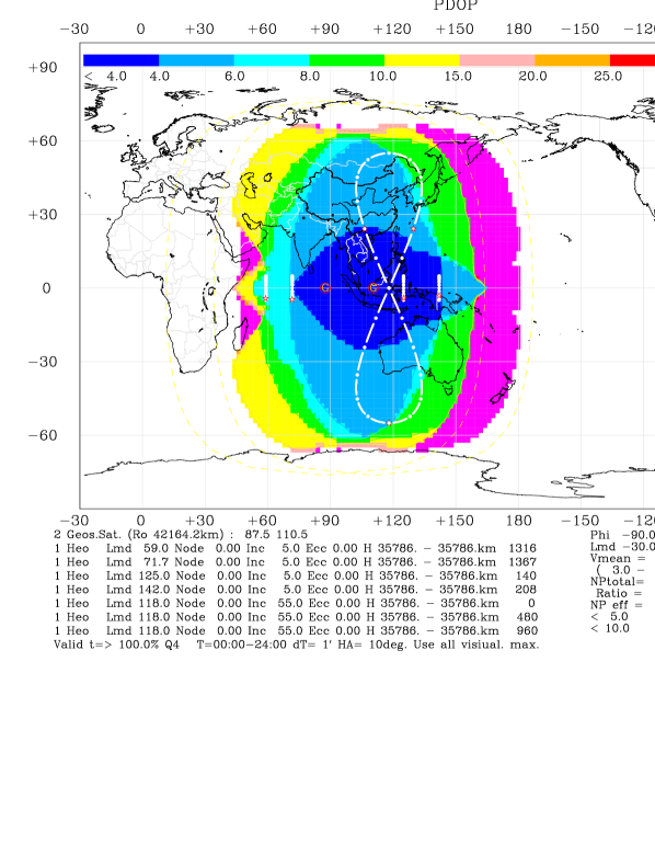
In navigation system based on SIGSO communication satellites, if several IGSO satellites are launched, the configuration will be greatly improved. One IGSO satellite is not adequate to obtain a satisfying improvement on PDOP for the reason that users in higher latitudes will fail to receive signals when the satellite is in the other hemisphere (Ma et al. 2011). We then adopt three IGSO satellites with inclination of 55∘ and cross node of 118∘E for instance, and the previous six satellites to assess the contributions of IGSO satellites. The amelioration of PDOP values contributed by the three IGSO satellites is noticeable. The 93 percent of the China area can get a 24-hour maximum PDOP value less than 6.2. The 93 percent of the area obtains the average PDOP value below 4.8. The minimum PDOP value in the 95 percent of the area is smaller than 3.5. The global distribution of maximum PDOP value over 24 hours is shown in Figure 4.
However, it should be pointed out that when only four satellites are observable, the PDOP value is inversely proportional to the volume of a tetrahedron described by unit vectors from the receiver to each of the four satellites. If endpoints of the four unit vectors are nearly coplanar, the PDOP value is infinitely large. For the constellation with three IGSO satellites and one GEO satellite, there are several time intervals in a day when the volume of the tetrahedron is close to zero and a 24-hour 3D positioning is thus not achievable. Further details can be found in Ma et al. 2012a .
6.2 New Techniques Coping with Interference
Interference is one of the greatest technical challenges satellite navigation systems face. The received signal power is lower than natural noise contained in the bandwidth. If man-made interference is added to natural noise, then the situation quickly becomes bleak (Kaplan & Hegarty 2006; Misra & Enge 2006).
Navigation frequencies are commonly settled when the system has been designed and in consequence there is no margin for switching frequencies in applications. As for navigation system based on SIGSO communication satellites, all C-band frequencies are available for navigation. New techniques such as frequency-switching, code-switching and satellite-switching can therefore be employed to enhance anti-interference performance. Frequency-switching only requires the corresponding change of receiving frequency when uplink frequency on the ground station alters. In code-switching technique, the receiver backs up several optional codes and applies the code adopted in navigation signal to track the signal and demodulate messages. To utilize satellite-switching technique, the ground station redirects antennas to other satellites and uplinks navigation signals, while users receive the transmitted signals to accomplish positioning.
6.3 Integration of Navigation and Communication
Besides PVT services, the transmission of position and time information is provided in the system based on SIGSO communication satellites. Satellite link budget, as an elemental optimized design, trades off various attenuation and gains of transmission links. It involves system capability and reliability, as well as investment in the ground station. Navigation transmission link includes both uplink and downlink, and downlink power is limited. An optimal design is requisite in order to guarantee successful reception and demodulation of navigation signals. Communication transmission link deserves more careful treatments as power is limited in two-way links. In addition, many system parameters should also conform to the ITU requirements (Cui et al. 2009).
Acknowledgements.
The authors are grateful to Profs. Yanben Han and Qiyuan Qiao for providing DOP analysis software. The work is carried out under the support of the National Basic Research and Development Program of China (Grant No. 2007CB815501), the Key Research Program of the Chinese Academy of Sciences (Grant No. KJCX2-EW-J01) and the Knowledge Innovation Program of the Chinese Academy of Sciences (Grant No. KGCX2-EW-407-1).References
- Ai et al. 2011 Ai, G. X, Ma, L. H., Shi, H. L., et al. 2011, Navigation, 58, 59
- Ai et al. 2012 Ai, G. X, Ma, L. H., Ji, H. F., Shi, H. L. 2012, Navigation, under review
- 3 Ai, G. X., Sheng, P. X., Du, J. L., et al. 2009a, Sci China Ser G-Phys Mech Astron, 52, 376
- Ai et al. 2008 Ai, G. X., Shi, H. L., Wu, H. T., et al. 2008, Chin J Astron Astrophys, 8, 611
- 5 Ai, G. X., Shi, H. L.,Wu, H. T., et al. 2009b, Sci China Ser G-Phys Mech Astron, 52, 472
- Cheng et al. 2012 Cheng, X., Li, Z. G., Yang, X. H., Wu, W. J., Lei, H., Feng, C. G. 2012, The Journal of Navigation, 65, 339
- Cui et al. 2009 Cui, J. X., Shi, H. L., Chen, J. B., et al. 2009, Sci China Ser G-Phys Mech Astron, 52, 402
- Han et al. 2009 Han, Y. B., Ma, L. H., Qiao, Q. Y., et al. 2009, Sci China Ser G-Phys Mech Astron, 52, 423
- Jing & Zhang 2009 Jing, Y. X & Zhang, Y. T. 2009, Phase Analysis of Geostationary Orbit Satellite, CAPS Technical Report
- Kaplan & Hegarty 2006 Kaplan, E. D. & Hegarty, C. J. 2006, Understanding GPS: Principle and Application, 2nd ed., Boston: Artech House
- Li & Dempster 2010 Li, B. H. & Dempster, A.G. 2010, InsideGNSS, 5, 59
- 12 Li, X. H., Wu, H. T., Bian, Y. J., Wang, D. N. 2009a, Sci China Ser G-Phys Mech Astron, 52, 353
- 13 Li, Z. G., Yang, X. H., et al. 2009b, Sci China Ser G-Phys Mech Astron, 52, 384
- Ma et al. 2012 Ma, G. Y., Wan, Q. T., Gan, T. 2012, RAA, 12, 601
- Ma 2011 Ma, L. H. 2011, Artificial Satellite, 46, 1
- Ma et al. 2011 Ma, L. H., Ai, G. X., Ji, H. F. 2011a, The Journal of Navigation, 64, S73
- 17 Ma, L. H., Ai, G. X., Ji, H. F. 2012a, Advance in Space Research , under review
- 18 Ma, L. H., Jing, Y. X., Ji, H. F., Zhang, L. R. 2011b, Astro Res & Tech, 8, 347
- Misra & Enge 2006 Misra, P., & Enge, P. 2006, Global Positioning System: Signal, Measurements, and Performance, 2nd ed., Lincoln: Ganga-Jamuna Press
- Shi et al. 2009 Shi, H. L., Ai, G. X., Han, Y. B., et al. 2009, Sci China Ser G-Phys Mech Astron, 52, 323
- 21 Shi, H. L., Sun, X. Y., Li, Z. G. 2009a, Principle of Transmitting Satellite Navigation System, Beijing: Science Press
- Zhang 1998 Zhang, R.W. 1998, Dynamics and Control of Satellite Orbit Attitude, Beijing: BeiHang University Press