Accurate Geodetic Coordinates for Observatories
on Cerro
Tololo and Cerro Pachón
Abstract
As the 50th anniversary of the Cerro Tololo Inter-American Observatory (CTIO) draws near, the author was surprised to learn that the published latitude and longitude for CTIO in the Astronomical Almanac and iraf observatory database appears to differ from modern GPS-measured geodetic positions by nearly a kilometer. Surely, the position for CTIO could not be in error after five decades? The source of the discrepancy appears to be due to the 30” difference between the astronomical and geodetic positions – a systematic effect due to vertical deflection first reported by Harrington, Mintz Blanco, & Blanco (1972). Since the astronomical position is not necessarily the desired quantity for some calculations, and since the number of facilities on Cerro Tololo and neighboring Cerro Pachón has grown considerably over the years, I decided to measure accurate geodetic positions for all of the observatories and some select landmarks on the two peaks using GPS and Google Earth. Both sets of measurements were inter-compared, and externally compared to a high accuracy geodetic position for a NASA Space Geodesy Program survey monument on Tololo. I conclude that Google Earth can currently be used to determine absolute geodetic positions (i.e. compared to GPS) accurate to roughly 0.15” (5 m) in latitude and longitude without correction, or approximately 0”.10 (3 m) with correction. I tabulate final geodetic and geocentric positions on the WGS 84 coordinate system for all astronomical observatories on Cerro Tololo and Cerro Pachón with accuracy 0”.1 (3 m). One surprise is that an oft-cited position for LSST is in error by 9.4 km and the quoted elevation is in error by 500 m.
Subject headings:
astronomical databases: miscellaneous – reference systems – telescopes – reference systems1. Motivation
For 50 years, the Association of Universities for Research in Astronomy (AURA)111http://www.aura-astronomy.org/ has supported a growing number of astronomical observatories on Cerro Tololo and Cerro Pachón. These observatories include ones operated by the National Optical Astronomy Observatories (NOAO)222http://www.ctio.noao.edu/noao/ and http://www.noao.edu/ and several other “tenant” scientific research facilities. Since the founding of the Cerro Tololo Inter-American Observatory and purchase of the “El Totoral” property 25 November 1962333“Brief History of the Cerro Tololo Inter-American Observatory” written by Victor Blanco in February 1993: http://www.ctio.noao.edu/noao/content/ctio-history, CTIO has provided a critical platform for astronomical observations of the southern skies444Including, of course, support for observations with the Blanco 4-m telescope for the High-Z Supernova Search team and Supernova Cosmology Project which led to the 2011 Nobel Prize in physics (e.g. Riess et al., 1998; Schmidt et al., 1998; Perlmutter et al., 1999), and important pioneering work by the Calán/Tololo SNe Ia survey (e.g. Hamuy et al., 1996). CTIO continues to provide support for the investigation of the cosmological acceleration through the Dark Energy Survey (DES) and Dark Energy Camera (DECam) project on the Blanco 4-m telescope., and continues to support impressive science on no less than two dozen facilities. The neighboring peak Cerro Pachón has been developed over the past two decades, hosting the SOAR555http://www.soartelescope.org/ and Gemini South666http://www.gemini.edu/ telescopes. The Large Synoptic Survey Telescope (LSST)777http://www.lsst.org/lsst/ is currently under construction on the El Peñón peak of Cerro Pachón. With excellent seeing, weather, monitoring and mitigation of light pollution, and strong legacy of development of infrastructure and trained staff, the Cerro Tololo and Cerro Pachón sites are well positioned to host astronomical observatories for the next half century.
The precise positions of the observatories on Cerro Tololo has been historically useful for a variety of purposes, including lunar occultations (e.g. Lasker et al., 1973; Vilas & Lasker, 1977), planetary occultations (e.g. French et al., 1983; Hubbard et al., 1997), planetary ring occultations (e.g. Elliot et al., 1981), and asteroid astrometry (e.g. Buie et al., 2012). Among other purposes, precise positions for telescopes on these peaks are important for applying velocity corrections for precise radial velocity measurements with the CHIRON spectrograph on the SMARTS 1.5-m telescope (Schwab et al., 2010), and will be important for accounting for geocentric parallax when determining orbits of nearby small solar system bodies imaged with the Dark Energy Camera (DECam) on the Blanco 4-m telescope and LSST.
Given the importance of a precise position for astronomical calculations, it came as a surprise to the author that the position for CTIO published in the Astronomical Almanac and in iraf obsdb.dat file (observatory database) differed from GPS-measured geodetic positions on Cerro Tololo by approximately a kilometer. As I discuss later, this is not an “error” per se. The discrepancy arises due to the mismatch in definitions between astronomical and geodetic coordinates (Harrington et al., 1972; Blanco & Mayall, 1972). However, the issue raised awareness that (1) there are conflicting (and sometimes incorrect) coordinates and elevations for facilities on Cerro Tololo and Cerro Pachón on the WWW and in the literature, and (2) coordinates have not yet been estimated for many of the new facilities on these peaks. Hence, an accessible review of the coordinates for the Tololo and Pachón facilities was long overdue.
This document is a summary of my notes and measurements for the coordinates of facilities on Cerro Tololo and Cerro Pachón. It may be updated later if improved measurements or corrections come to light. After some discussion on terrestrial coordinate systems (§2), historical review and document archaeology (§3), I present new measurements of accurate geodetic and geocentric coordinates for the astronomical facilities on Cerro Tololo and Cerro Pachón (§4), and intercompare the measurements and assess their accuracy (§5). The best estimates of the coordinates for the observatories are compiled in Table 6. The document was first written in mid-2012, and a summary of revisions is provided after the bibliography.
2. Background on Coordinate and Elevation Systems
Following the ISO 6709 standard, geodetic positions in this paper are quoted as latitude (), longitude (), and elevation () on the World Geodetic System 84 (WGS 84) coordinate frame, unless otherwise noted. Elevations will be discussed later in this section, as they require a more detailed explanation. North latitude and east longitude are positive. Longitude 0∘ on the WGS 84 frame corresponds to the International Reference Meridian defined by the International Earth Rotation and Reference Systems Service (IERS), which lies approximately 5” (100 m) east of the meridian at the Royal Observatory in Greenwich. One degree (∘) of latitude is 110.86 km, one minute () is 1.85 km, and one second () is 30.8 m. At the latitude of Cerro Tololo, one degree of longitude is 96.32 km, one minute () is 1.61 km, one second is 26.8 m.
Global Position System (GPS; also called NAVSTAR) is the well known navigation system supported by a constellation of 24 orbiting satellites launched by the U.S. Department of Defense (e.g. Hofmann-Wellenhof et al., 1992). Altitudes measured by GPS are referenced to a gravitational equipotential surface that defines sea level: the World Geodetic System 84 (WGS 84). According to a Department of Defense publication tilted “Military Standard for Department of Defense World Geodetic System (WGS)”888Document MIL-STD-2401, dated 11 January 1994, http://earth-info.nga.mil/publications/specs/printed/2401/2401.pdf, the WGS 84 provides “the basic reference frame (coordinate system), geometric figure for the earth (ellipsoid), earth gravitational model, and means to relate positions on various geodetic datums and systems for DoD operations and applications.” The WGS 84 geometric figure is an oblate spheroid with radius at the equator of 6378137 m, and a flattening of = 1/298.257223563 (with a corresponding polar radius of approximately 6356752 m. While there is a 1984 version of the geoid model, there have been later updates of the Earth Gravitational Model (EGM; e.g. EGM96)999For further details on WGS 84 and its minor alterations over the past decades, see NIMA Technical Report TR8350.2, ”Department of Defense World Geodetic System 1984, Its Definition and Relationships With Local Geodetic Systems”, 3rd edition, Amendment 1 (3 Jan 2000): http://earth-info.nga.mil/GandG/publications/tr8350.2/tr83502.html. – indeed improving the resolution and accuracy of the geoid model is a never-ending pursuit of the geodesy community101010http://www.iag-aig.org/.
Quoted latitudes are usually geodetic (), which measure the angle between a normal at a position on a spheroid, and the equatorial plane. Sometimes geocentric latitudes () are quoted, measuring the angle between the line between the surface position and the Earth’s center, and the equatorial plane. Geodetic and geocentric longitudes are identical as they share the same axis and reference meridian. Geodetic latitudes () and geocentric latitudes () at Tololo and Pachón differ by 10’. Conversions for geodetic and geocentric coordinates can be found in Sec. 4 of the Explanatory Supplement to the Astronomical Almanac (Seidelmann, 1992).
One can define geodetic height with respect to the reference ellipsoid. Elevations are classically defined with respect to mean sea level, however this does not follow the ellipsoid exactly due to the local concentration of mass – and of course defining sea level on land is not trivial. Earth gravitational models (EGMs) are mathematical approximations for the geoid, the Earth’s gravitational equipotential surface. The gravitational vector is perpendicular to the geoid. The ocean’s mean sea level roughly follows the geoid, so one needs to define the geoid in order to quote altitudes with respect to “mean sea level” on land, as is commonly done. The geoid varies from the ellipsoid shape by deviations of up to approximately 100 m. In reality, the geoid is a very complicated and irregular surface following local concentrations of mass. In practice, it is defined by high order spherical harmonic expansion expressions. One commonly used EGM is Earth Gravitational Model 1996 (EGM96). This defines the geoid with a spherical harmonic series of = 360 (100 km resolution). There are three different “heights” of note: geodetic height (), orthometric height or elevation (), and geoid height (). They are related as:
| (1) |
i.e. the elevation is equal to the geodetic height minus the geoid height (measured with respect to the reference ellipsoid; see Chapter 4 of Seidelmann, 1992).
An online tool from UNAVCO111111http://www.unavco.org/communityscience/science-support/geoid/geoid.html was used to estimate the geoid height on the EGM96 model for Cerro Tololo and Cerro Pachón. The mean geoid heights for Tololo and Pachón are approximately 34.6 and 35.0 meters, respectively. Geoid heights at individual observatories will be tabulated at the end of the paper. EGM96 geoid heights across both peaks vary at the 0.1 m level from site to site. There are subtle differences in geoid models as they have improved in accuracy and resolution over the years. For example, at the position of the Blanco 4-m telescope, the (EGM84, EGM96, and EGM2008121212http://earth-info.nga.mil/GandG/wgs84/gravitymod/egm2008/ index.html 131313http://geographiclib.sourceforge.net/cgi-bin/GeoidEval) Earth gravitational models predict geoid heights = (31.41, 34.62, 33.31) meters. Hence, the definition of “mean sea level” under the observatories has varied at the few meter level over the past decades. Throughout this paper, all geoid heights refer to the EGM96 model, unless otherwise noted.
To what degree are Cerro Tololo and Cerro Pachón moving due to plate tectonics? While the common perception is that Chile is moving westward with the South American tectonic plate, there are surprisingly large variations in the plate motion in Chile. These large variations are traced through time series GPS measurements of ground stations in Chile maintained by the Jet Propulsion Laboratory141414http://sideshow.jpl.nasa.gov/mbh/series.html. Generally, stations north of Santiago (Santiago, Valparaíso, Copiapó, Iqueque) are moving northeast with respect to WGS 84 at 30 mm/yr, while Chilean stations south of Santiago are moving northwest at 90 mm/yr. Although I have been unable to find accurate geodetic motions for Cerro Tololo and Cerro Pachón in particular, judging by the measurements for other well-studied benchmarks in Chile, it is very likely that the peaks are moving at 100 mm/yr, and most likely 30 mm/yr. UNAVCO151515http://www.unavco.org/communityscience/science-support/crustalmotion/dxdt/model.html provides a plate motion calculator (model GSRM v1.2) on their website, and at Cerro Tololo’s position, they predict that the South American plate is moving with respect to the WGS 84 coordinate system at 9.24 mm/yr (9.17 mm/yr N, 1.10 mm/yr E) - however this velocity is substantially smaller than those reported for northern Chile JPL stations. Hence, over the five decade history of the observatory, the site has very likely moved 5 m (and indeed the UNAVCO plate motion calculator would predict only 0.5 m of motion over 50 years). In summary, any deviations in the published positions for the observatory larger than these amounts are unlikely to be attributable to tectonic motion, especially on short timescales.
3. Previous Coordinates and Elevations
3.1. Coordinates
Past published positions for Cerro Tololo and Cerro Pachón and individual structures are listed in Table 1. The Astronomical Almanac (AA; e.g. U. S. Government Printing Office (2013), USGPO) often listed positions for individual telescopes at major observatories during the early 1980’s, but only listed positions for 4 telescopes on Tololo in the 1982 edition: the Blanco 4-m reflector, the 1.5-m reflector, the 1-m reflector, and the 24” Curtis Schmidt telescope. These positions were presumably adopted from the CTIO facilities manual (e.g. Walker & Muñoz, 1980). The AA ceased listing positions for individual telescopes at observatories after the mid-80’s, and provided only mean positions for observatories thereafter. Note that the AA concedes that the observatory positions are a mix of geodetic and astronomical values, and the type of position is not provided.
| Site | Ref. | Elev. | Notes | ||||||
|---|---|---|---|---|---|---|---|---|---|
| ’ | ” | ’ | ” | (m) | |||||
| Cerro Tololo | |||||||||
| CTIO | Mayall (1968) | -30 | 10 | 00 | -70 | 49 | 00 | 2200 | |
| CTIO | Blanco & Mayall (1972) | -30 | 09 | 531.8 | -70 | 48 | 543 | … | Astronomical, |
| CTIO | Harrington et al. (1972) | -30 | 09 | 56 | -70 | 48 | 16 | 2210 | Topographic Map, |
| CTIO | Walker & Muñoz (1980) | -30 | 10 | 08.20.4 | -70 | 48 | 21.10.4 | 2210 | Geodetic, |
| CTIO | AA 1975-1980 | -30 | 10 | 08.2 | -70 | 48 | 24 | 2399 | |
| CTIO | iraf | -30 | 09 | 55 | -70 | 48 | 54 | 2215 | |
| CTIO | AA 1983-2013 | -30 | 09 | 54 | -70 | 48 | 54 | 2215 | |
| CTIO | MPC(2012) | … | … | … | -70 | 48 | 21 | … | |
| Blanco 4-m | Walker & Muñoz (1980) | -30 | 09 | 57.8 | -70 | 48 | 53.6 | 2210 | |
| Blanco 4-m | AA 1982 | -30 | 09 | 57.8 | -70 | 48 | 53.6 | 2235 | |
| Blanco 4-m | Hubbard et al. (1997) | -30 | 09 | 57.8 | -70 | 48 | 53.6 | 2235 | |
| SMARTS 1.5-m | AA 1982 | -30 | 09 | 56.3 | -70 | 48 | 54.5 | 2225 | |
| SMARTS 1.5-m | Walker & Muñoz (1980) | -30 | 09 | 56.3 | -70 | 48 | 54.5 | 2210 | Astronomical |
| SMARTS 1.3-m | MPC(2012) | … | … | … | -70 | 48 | 21 | … | |
| SMARTS 1.0-m | Walker & Muñoz (1980) | -30 | 09 | 54.8 | -70 | 48 | 51.9 | 2210 | Astronomical |
| SMARTS 0.9-m | Walker & Muñoz (1980) | -30 | 09 | 54.8 | -70 | 48 | 53.9 | 2210 | Astronomical |
| Schmidt 0.6-m | Harrington et al. (1972) | -30 | 10 | 08.20.4 | -70 | 48 | 21.10.4 | 239910 | Geodetic, |
| Schmidt 0.6-m | Harrington et al. (1972) | -30 | 09 | 55.51.4 | -70 | 48 | 52.72.0 | 2210 | Astronomical, |
| Tololo “O” | AURA survey notes | -30 | 10 | 01.345 | -70 | 48 | 58.408 | 2211.60 | |
| NASA Monument 7401 | NASA | -30 | 10 | 20.86692 | -70 | 48 | 00.15364 | 2123.090 | Geodetic, |
| PROMPT | PROMPT website | -30 | 10 | 03.50 | -70 | 48 | 19.40 | … | |
| LCOGT | LCOGT website | -30 | 10 | 08.4 | -70 | 48 | 14.4 | 2200 | |
| Cerro Pachón | |||||||||
| Gemini S. | AA 2013 | -30 | 13 | 42 | -70 | 43 | 24 | 2725 | |
| Gemini S. | iraf | -30 | 13 | 42 | -70 | 43 | 24 | 2737 | |
| Gemini S. | Gemini website | -30 | 14 | 26.700 | -70 | 44 | 12.096 | 2722 | |
| Gemini S. | Zombeck (2007) | -30 | 14 | … | -70 | 43 | … | 2715 | |
| LSST | Ivezic et al. (2008a, b) | -30 | 10 | 20.1 | -70 | 48 | 00.1 | 2123 | |
| LSST | LSST website | … | … | … | … | … | … | 2647 | |
| LSST Auxiliary | LSST website | … | … | … | … | … | … | 2647 | |
| SOAR | Simms et al. (2005) | -30 | 14 | 16.8 | -70 | 44 | 01.4 | 2738 | |
| SOAR | Zombeck (2007) | -30 | 21 | … | -70 | 49 | … | 2701 | |
| SOAR | SOAR website | … | … | … | … | … | … | 2701 | |
| Pachón monument (near SOAR) | AURA survey notes | -30 | 14 | 13.393 | -70 | 44 | 04.396 | 2724.60 | |
Note. — I list longitude as measured with east being positive, following the 2013 Astronomical Almanac (U. S. Government Printing Office (2013), USGPO). In the first column, hyperlinks are provided to plot the coordinates on Google Maps for comparison. Notes: () Mayall (1968) position is quoted longitude as 4h 43m 16s W. () Blanco & Mayall (1972) geodetic position determined from observations of GEOS B satellite with Curtis Schmidt telescope from Harrington et al. (1972) study. Blanco & Mayall (1972) also lists the Harrington et al. (1972) astronomical coordinates. () Harrington et al. (1972) “approximate coordinates, taken from a topographic sheet based on the 1924 International Reference Ellipsoid and the 1956 Provisional South American Datum…”. () Walker & Muñoz (1980) adopts the geodetic coordinates for the Schmidt telescope from Harrington et al. (1972). () iraf position in obsdb.dat files: see e.g. http://tdc-www.harvard.edu/iraf/rvsao/bcvcorr/obsdb.html. () MPC longitude was listed as 289∘.1941, with cos() = 0.86560 and sin() = -0.49980 (see http://www.minorplanetcenter.net/iau/lists/ObsCodes.html). () Harrington et al. (1972) measured the astronomical position through timing the transits of stars with SAO catalog astrometry. They determined the geodetic position through measuring and timing positions of the GOES-II satellite (which had a well-determined orbit, and strobe lights which flashed sequences of 7 1.4 ms pulses every 4 s). The geodetic height is “above ellipsoid”, (however which ellipsoid is not explicitly mentioned (but given that the observations analyzed in 1971, it is likely WGS 66). () “O” is Tololo Control survey monument SE of Blanco 4-m. Values from AURA survey notes from Don Cassidy which triangulated the position from Peralillo and Pachón survey markers using theodolite observations, tied to elevations determined by Instituto Geographic Militar (IGM). () NASA website (Space Geodesy Program): http://cddis.nasa.gov/sitecat/cerr.html. () LCOGT website: http://lcogt.net/site/cerro-tololo. () Gemini website: http://www.gemini.edu/sciops/telescopes-and-sites/locations. () LSST website: http://www.lsst.org/lsst/science/summitfacilities. () SOAR website: http://www.soartelescope.org/about-soar/location-1.
The Minor Planet Center (MPC) lists161616http://www.minorplanetcenter.net/iau/lists/ObsCodesF.html two observatory code entries for CTIO: #807 (Cerro Tololo Observatory, La Serena) and #I02 (Cerro Tololo, La Serena–2MASS). At the time of writing (16 July 2012), the MPC lists identical longitudes , and parallax constants cos and sin for these two codes: = 289∘.1941 (degrees east of Greenwich), and cos = 0.86560 and sin = -0.49980. “” in this case is apparently geocentric latitude, and should be labeled to distinguish it from geodetic latitude . From these last two quantities we can calculate the parallax parameter to be 0.999532, and latitude = -30∘.00228 = -30∘00’08”. This is in good agreement with values derived later in this paper.
3.2. 1972 Harrington et al. Determination of Astronomical and Geodetic Coordinates
In an annual report, Blanco & Mayall (1972) reported the following regarding
the coordinates for CTIO:
“A program to determine the precise geodetic and geographic
positions of Cerro Tololo was initiated by Dr. R. Harrington, U.S.
Naval Observatory, Washington D.C., and Dr. and Mrs. V. M. Blanco,
CTIO. Observations of the GEOS B satellite, which was flashed
especially for this purpose, were made with the Curtis Schmidt
telescope. The final reductions made at the Goddard Space Flight
Center yield the following geodetic position:
= -30∘ 10’ 8”.2, = W 70∘ 48’
21”.1. The geographic or astronomical position was determined
by the method of equal altitudes with data obtained from a series
of theodolite observations. The preliminary results are
= -30∘ 9’ 53” 1”.8, =
W 70∘ 48’ 54” 3”. These figures suggest a
deflection of the vertical of approximately 39 arc sec in the
west-northwesterly direction, approximately perpendicular to the
orientation of the Andean Cordillera and the deep off-shore
Chile-Peru oceanic trench, which are the probable sources of the
deflection.”
Examination of the original Harrington et al. (1972) study171717 A
copy of the Harrington et al. (1972) study proved exceedingly difficult
to find, but the NOAO North library has a copy. A scanned copy can
be downloaded at
http://www.pas.rochester.edu/emamajek/Harrington72.pdf.
suggests a typo in the deflection of vertical measured. The
astronomical and geodetic coordinates for the Curtis Schmidt telescope
on Tololo are listed in Table 1. Harrington et al. (1972)
concluded:
“The astronomic coordinates of the Curtis Schmidt telescope
can be compared to the above geodetic coordinates to obtain the
deflection of the vertical. This deflection amounts to
30”.1 1”.7 towards an azimuth of
295∘ 3∘, which corresponds to
approximately 930 meters on the ellipsoid surface.”
Hence, the source of the discrepancy between the Almanac and iraf positions for CTIO and what one would measure with a GPS or on Google Earth appears to be due to the difference in the type of latitude and longitude being reported (i.e. astronomical vs. geodetic). While the astronomical position is useful for calculating transit times, it may not be the position desired for other calculations (e.g. taking into account geocentric parallax, occultation calculations, etc.).
3.3. 1973 Survey Elevations
I list in Table 2 elevations for the concrete platforms for observatories on the Tololo plateau from a 1973 survey map from the NOAO Engineering Department181818Contains note “Survey map drawn by E.W. Ross, checked & approved by Don Cassidy, Oct 12, 1971.”. The concrete platforms for all of the observatories on the Tololo plateau have elevations ranging from 2209.60 m (SMARTS/Yale 1.0-m) to 2210.50 m (Blanco 4-m), i.e. less than = 1.1 m among them. The elevations quoted in the survey are tied to topography from the “Fuerza Aerea de Chile - Servicio Aeoro Fotogrametrico (November 1964)” and “supplemented by plane table topography by AURA October 1966.” The topography of the Tololo plateau was tied to elevations of neighboring peaks with coordinates provided by the IGM (including Cerro Pachón and Cerro Peralillo) via a primary survey monument called ”Tololo”, ”Tololo Control”, or ”O” on the old survey maps (discussed further in §5.2.1). The Tololo survey monument was assigned elevation 2211.60 m above sea level. Separate notes from this period list an elevation of 2724.60 m for an IGM survey monument on Cerro Pachón, however it is not clear whether this monument corresponds to one of the modern day survey monuments on Pachón as the site has been developed considerably in the intervening four decades.
| Observatory | ||
|---|---|---|
| (m) | (m) | |
| Blanco 4-m (158”) | 2210.50 | -1.10 |
| SMARTS 1.5-m (60”) | 2210.99 | -0.61 |
| SMARTS 1.0-m (40”) | 2209.60 | -2.00 |
| SMARTS 0.9-m (36”) | 2210.49 | -1.11 |
| Curtis Schmidt 0.6-m (24”) | 2210.00 | -1.60 |
| No. 1 16” (later USNO) | 2210.31 | -1.29 |
| No. 2 16” (later CHASE) | 2209.65 | -1.95 |
| Tololo Control survey monument | 2211.60 | 0.00 |
Note. — is elevation scale measured with respect to sea level, tied to topography established by Fuerza Aerea de Chile - Servicio Aero Fotogrametrico, and supplemented by plane table topography measured by AURA. Later calculations show that the 1973 survey elevations appear to assume a geoid within a meter or so of the EGM-84 model. is differential elevation with respect to Tololo Control survey monument. The mean elevation of the 7 platforms is 2210.22 m. Their mean height on Google Earth is 2202.7 m. Their mean height measured via GPS is 2217.6 m.
3.4. 2008 Survey Elevations
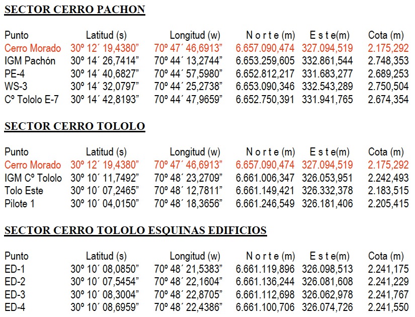
In Figure 1, I show a scanned table from a 2008 survey of Cerro Tololo, Cerro Pachón, and the neighboring peak Cerro Morado (S of Tololo, NW of Pachón), completed by Juan Carlos Aravena Godoy for AURA. Cerro Morado has a Instituto Geographico Militar (IGM) survey monument with well determined geodetic coordinates, which were provided to the surveyers by the Chilean Army (highlighted in red in Fig. 1). The coordinates are on the WGS 84 system (as adopted by SIRAS, the Sistema de Referencia Geocéntrico para las Américas), and elevations are with respect to the GRS 80 ellipsoid. The difference in geocentric radii between the GRS 80 and WGS 84 ellipsoids at the position of the Blanco 4-m is 26 m (i.e. 10-4.6 m). Hence, for all practical purposes, the differences between the GRS 80 ellipsoid adopted by SIRGAS (used in Chilean surveying) and the WGS 84 ellipsoids, are completely negligible 191919The only difference between the WGS 84 and GRS 80 reference ellipsoid is due to the adopted flattening parameter () - in the 6th decimal place. So throughout, it is safe to assume that GRS 80 is equivalent to WGS 84. See also: NIMA Technical Report TR8350.2, ”Department of Defense World Geodetic System 1984, Its Definition and Relationships With Local Geodetic Systems”, 3rd edition, Amendment 1 (3 Jan 2000): http://earth-info.nga.mil/GandG/publications/tr8350.2/tr83502.html.. The 2008 survey also measured positions for 4 survey monuments near the Schmidt telescope on the Tololo plateau. The elevations ranged from 2241.175 to 2241.767 m, i.e. = 0.652 m, and = 2241.430 m (elevations are with respect to the GRS 80 ellipsoid). This is probably representative of the GRS 80 heights of the concrete platforms for the observatories on the Tololo plateau. The 1970s-era survey notes also list elevations for 4 pins distributed around the Schmidt telescope, with elevations ranging from 2209.333 to 2209.985 m ( = 0.592 m; = 2209.650 m), and given the description and close agreement in spread of elevations, these are likely to be the same pins as measured in the 2008 survey. Both the Tololo Control and Schmidt survey monument measurements indicate that the 1973 survey maps can be converted to be geodetic heights with respect to the GRS 80 (WGS 84) ellipsoid by adding 31 m. This difference is not far from the geoid undulations predicted for Tololo’s position in recent EGM models (§5.2.2). These numbers seem to confirm that the 2008 survey elevations have not subtracted off geoid undulation, and they are simply with respect to the GRS 80 ellipsoid (hence, they are likely to have non-zero elevations at mean sea level).
4. Measurements
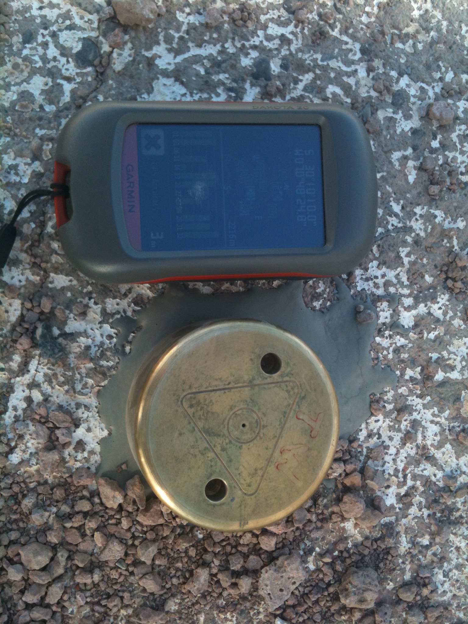
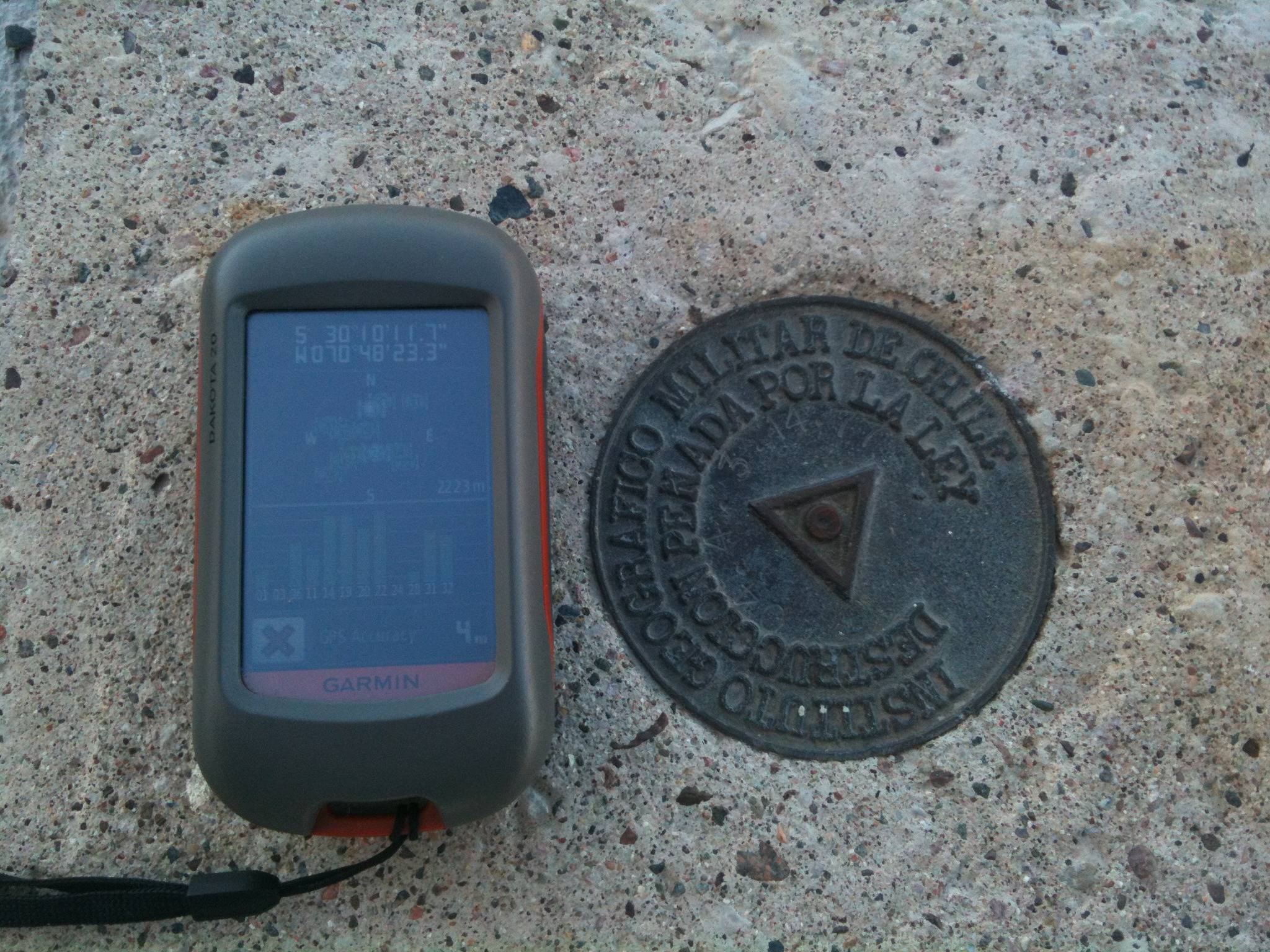
GPS (Garmin): Positions were measured with a Garmin brand Dakota 20 GPS202020Courtesy of Michael Warner (CTIO)., shown in Figure 2. This GPS was set to update at 1 second intervals, quoted positions to 0”.1 precision and elevations to 1 m precision, and provided a regularly updated estimate of the position accuracy. Typical quoted accuracy in a 1 sec interval ranged from as good as 3 m (with unobstructed view and several satellites acquired), and at times as bad as 20 m, close to the advertised212121http://www8.garmin.com/aboutGPS/ mean accuracy of 15 m.
Measurements were taken in different modes. As the GPS would not operate inside of domes due to obstructed view, I typically took two sequences of measurements at four corners of a given structure, and averaged the results. For assymetric structures (e.g. Gemini, SOAR), I did some simple interpolation to estimate the central position. The GPS positions were very repeatable at the 0.1” level (only very rarely would subsequent measurements taken minutes apart differ by 0.2”). Measurements were either taken (1) with the device sitting on the flat cement platforms outside of the domes, or the ground if there was no platform, or (2) with the device held in the hand, approximately 1 meter above the ground. None of the elevation measurements taken in this manner are quoted to better than 1 m precision. For GPS measurements of geodetic benchmarks and observatory sites currently lacking enclosures (e.g. KASI and T80-S), the GPS device was left sitting on the ground at the position, and coordinates were saved at 1 s or 5 s intervals for extended periods of time to the GPS’s memory. As the GPS would often read out precisely the same coordinates for several seconds on end (then jump small amounts, presumably due to acquiring and losing individual satellites), it was decided to measure statistical moments only on unique coordinate sets in the time series data. Especially long time series measurements were made of the benchmarks next to the SMARTS 1.5-m and NASA geodesy benchmark next to the SARA (former Lowell 24”) telescope.
GPS (iPhone): Auxiliary GPS measurements were made with an iPhone 3s using Entel phone service, and using the application Compass. The iPhone measurements suffered two major limitations: sparse network coverage on the mountains, and the latitudes and longitudes were listed at 1” precision. Elevation estimates were also made using the iPhone application Current Elevation222222http://itunes.apple.com/us/app/current-elevation/id429847648. As the quoted positions were at lower precision than those provided by the Garmin GPS, and far fewer measurements were taken with the iPhone, I will not list these measurements. They do provide a consistency check on the Garmin GPS results, and indeed the iPhone coordinates appeared consistent with the Garmin results at the 1” level, when available.
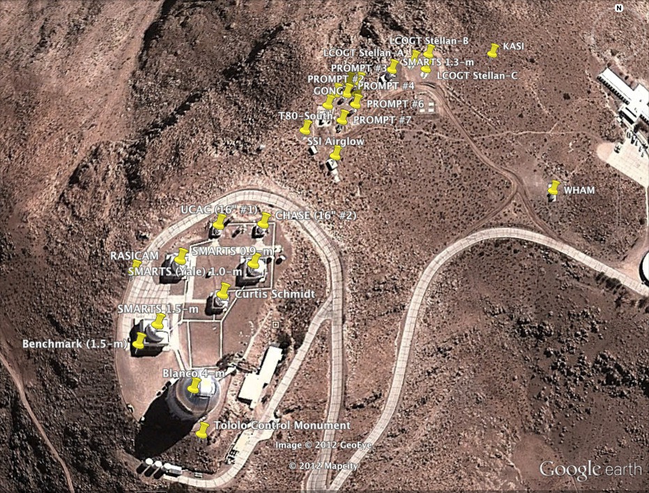
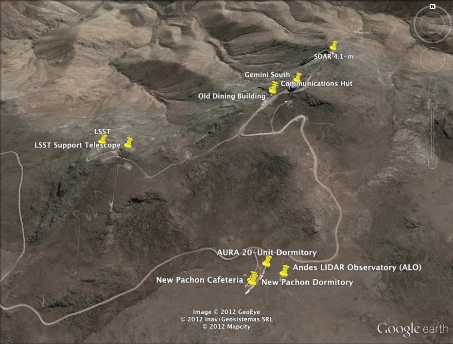
Google Earth: I used Google Earth 5.1 downloaded from the Google website232323http://www.google.com/earth/index.html and installed on a MacBook Pro running Mac OS X 10.6.8. Google Earth is a “virtual globe” that superposes satellite imagery over digital elevation model (DEM) data from the Shuttle Radar Topography Mission (SRTM). SRTM was a dual radar system that flew on Space Shuttle Endeavour in February 2000, producing a high resolution elevation model, and was a project lead by the National Geospatial-Intelligence Agency (NGA) and NASA (Farr et al., 2007). SRTM elevation data are on the WGS 84 coordinate system, adopt the EGM96 vertical datum (geoid), and for Chile the spatial resolution is 3” (100 m). Hence, the Google Earth data from SRTM suffers from low resolution which may miss fine structure, and any leveling of sites over the past decade (e.g. LSST sites). Google Earth images of Cerro Tololo and Cerro Pachón are shown in Figures 3 and 4, respectively, with observatories and survey monuments marked.
5. Results
Individual determinations of the geodetic positions for the observatories on Cerro Tololo and Cerro Pachón are tabulated in Table 3. Additional measurements for other facilities on the two peaks are tabulated in Table 4.
| Site | Method | |||||||
|---|---|---|---|---|---|---|---|---|
| ’ | ” | ’ | ” | (m) | ||||
| Blanco 4-m | GPS | -30 | 10 | 10.73 | -70 | 48 | 23.52 | 2213 |
| (fmr. 150” or 158”) | GE | -30 | 10 | 10.73 | -70 | 48 | 23.32 | 2204 |
| SMARTS 1.5-m | GPS | -30 | 10 | 09.53 | -70 | 48 | 24.49 | 2218 |
| (former 60”) | GE | -30 | 10 | 09.20 | -70 | 48 | 24.24 | 2208 |
| SMARTS 1.0-m | GPS | -30 | 10 | 07.94 | -70 | 48 | 21.82 | 2217 |
| (former Yale 40”) | GE | -30 | 10 | 07.79 | -70 | 48 | 21.69 | 2201 |
| SMARTS 0.9-m | GPS | -30 | 10 | 08.00 | -70 | 48 | 23.90 | 2217 |
| (former 36”) | GE | -30 | 10 | 07.69 | -70 | 48 | 23.67 | 2203 |
| Curtis Schmidt 0.6-m | GPS | -30 | 10 | 08.59 | -70 | 48 | 22.62 | 2219 |
| (former 24”) | GE | -30 | 10 | 08.50 | -70 | 48 | 22.49 | 2207 |
| Former UCAC | GPS | -30 | 10 | 06.93 | -70 | 48 | 22.85 | 2222 |
| (former 16” #1) | GE | -30 | 10 | 06.87 | -70 | 48 | 22.65 | 2200 |
| Former CHASE | GPS | -30 | 10 | 06.99 | -70 | 48 | 21.71 | 2217 |
| (former 16” #2, MMWT) | GE | -30 | 10 | 06.84 | -70 | 48 | 21.44 | 2196 |
| RASICAM | GPS | -30 | 10 | 07.99 | -70 | 48 | 25.10 | 2214 |
| … | GE | -30 | 10 | 07.96 | -70 | 48 | 24.97 | 2200 |
| WHAM | GPS | -30 | 10 | 05.84 | -70 | 48 | 12.79 | 2159 |
| … | GE | -30 | 10 | 05.89 | -70 | 48 | 12.77 | 2154 |
| KASI | GPS | -30 | 10 | 01.84 | -70 | 48 | 14.39 | 2157 |
| … | GE | … | … | … | … | … | … | 2140a |
| LCOGT Stellan-A | GPS | -30 | 10 | 02.67 | -70 | 48 | 17.33 | 2170 |
| … | GE | -30 | 10 | 02.38 | -70 | 48 | 17.00 | 2146 |
| LCOGT Stellan-B | GPS | -30 | 10 | 02.48 | -70 | 48 | 16.90 | 2170 |
| … | GE | -30 | 10 | 02.20 | -70 | 48 | 16.52 | 2144 |
| LCOGT Stellan-C | GPS | -30 | 10 | 02.87 | -70 | 48 | 16.93 | 2170 |
| … | GE | -30 | 10 | 02.65 | -70 | 48 | 16.63 | 2151 |
| SMARTS 1.3-m | GPS | -30 | 10 | 02.84 | -70 | 48 | 18.01 | 2170 |
| … | GE | -30 | 10 | 02.67 | -70 | 48 | 17.68 | 2151 |
| PROMPT #1 | GE | -30 | 10 | 03.42 | -70 | 48 | 18.77 | 2162 |
| PROMPT #2 | GE | -30 | 10 | 03.39 | -70 | 48 | 19.42 | 2161 |
| PROMPT #3 | GE | -30 | 10 | 03.07 | -70 | 48 | 18.71 | 2157 |
| PROMPT #4 | GPS | -30 | 10 | 03.59 | -70 | 48 | 19.40 | 2178 |
| … | GE | -30 | 10 | 03.42 | -70 | 48 | 19.09 | 2162 |
| PROMPT #5 | GE | -30 | 10 | 03.06 | -70 | 48 | 19.02 | 2156 |
| PROMPT #6 | GE | -30 | 10 | 03.72 | -70 | 48 | 18.82 | 2166 |
| PROMPT #7 | GPS | -30 | 10 | 04.38 | -70 | 48 | 19.34 | 2179 |
| … | GE | -30 | 10 | 04.17 | -70 | 48 | 19.23 | 2172 |
| GONG | GPS | -30 | 10 | 03.98 | -70 | 48 | 19.89 | 2184 |
| … | GE | -30 | 10 | 03.75 | -70 | 48 | 19.64 | 2167 |
| SSI Airglow | GPS | -30 | 10 | 05.35 | -70 | 48 | 19.55 | 2183 |
| … | GE | -30 | 10 | 05.11 | -70 | 48 | 19.43 | 2178 |
| SARA South 0.6-m | GPS | -30 | 10 | 19.73 | -70 | 47 | 57.11 | 2123 |
| (Lowell 24”) | GE | -30 | 10 | 19.61 | -70 | 47 | 57.00 | 2112 |
| T80-South (site) | GPS | -30 | 10 | 04.31 | -70 | 48 | 20.48 | 2187 |
| … | GE | … | … | … | … | … | … | 2175a |
| Gemini South | GPS | -30 | 14 | 26.54 | -70 | 44 | 12.13 | 2722 |
| … | GE | -30 | 14 | 26.70 | -70 | 44 | 11.84 | 2711 |
| SOAR | GPS | -30 | 14 | 16.21 | -70 | 44 | 00.84 | 2712 |
| … | GE | -30 | 14 | 16.51 | -70 | 44 | 01.24 | 2688 |
| LSST 8.4-m (site) | GPS | -30 | 14 | 40.68 | -70 | 44 | 57.90 | 2652 |
| … | GE | … | … | … | … | … | … | 2633a |
| LSST Auxiliary 1.4-m (site) | GPS | -30 | 14 | 41.27 | -70 | 44 | 51.80 | 2652 |
| … | GE | … | … | … | … | … | … | 2627a |
| Andes LIDAR Obs. (ALO) | GPS | -30 | 15 | 06.39 | -70 | 44 | 17.48 | 2519 |
| … | GE | -30 | 15 | 06.24 | -70 | 44 | 17.37 | 2522 |
Note. — GPS = Global Positioning System, measured using Garmin Dakota 20 unit. GE = Google Earth (26 March 2011 image of Tololo, 11 Apr 2011 image of Pachón). Geodetic latitude , longitude on WGS 84 system. Elevation is orthometric height with respect to geoid. Google Earth adopts the EGM96 geoid, however the adopted geoid used by the Dakota 20 GPS is ambiguous. The KASI, T80-S, LSST, and LSST Support sites were undeveloped at the time of the latest Google Earth images (hence no coordinates could be determined visually). = Google Earth elevation at the GPS position for this facility. The LSST and LSST Auxiliary sites were unleveled during the time (2000) of the SRTM elevation mapping used by Google Earth, so are not reliable.
| Site | Method | |||||||
|---|---|---|---|---|---|---|---|---|
| ’ | ” | ’ | ” | (m) | ||||
| NASA Monument 7401 | GPS | -30 | 10 | 20.919 | -70 | 48 | 00.096 | 2124.1 |
| (Site 892, W of SARA) | GE | -30 | 10 | 20.90 | -70 | 48 | 00.01 | 2124 |
| Monument (SW of 1.5-m) | GPS | -30 | 10 | 09.76 | -70 | 48 | 24.93 | 2214.0 |
| … | GE | -30 | 10 | 09.67 | -70 | 48 | 24.78 | 2206 |
| Tololo Control Monument | GPS | -30 | 10 | 11.75 | -70 | 48 | 23.25 | 2222 |
| (SE of Blanco) | GE | … | … | … | … | … | … | 2201 |
| Round Office Building | GPS | -30 | 10 | 07.91 | -70 | 48 | 09.53 | 2158 |
| (Tololo) | GE | -30 | 10 | 07.83 | -70 | 48 | 09.40 | 2151 |
| AURA 20 Unit Dormitory | GPS | -30 | 15 | 04.38 | -70 | 44 | 20.80 | 2502 |
| (Pachón) | GE | -30 | 15 | 04.34 | -70 | 44 | 20.75 | 2506 |
| New Dormitory | GPS | -30 | 15 | 07.54 | -70 | 44 | 23.64 | 2503 |
| (Pachón) | GE | -30 | 15 | 07.64 | -70 | 44 | 23.80 | 2503 |
| New Dining Building | GPS | -30 | 15 | 07.26 | -70 | 44 | 24.01 | 2503 |
| (Pachón) | GE | -30 | 15 | 07.22 | -70 | 44 | 23.97 | 2500 |
| Old Dining Building | GPS | -30 | 14 | 29.25 | -70 | 44 | 17.76 | 2699 |
| (Pachón) | GE | -30 | 14 | 29.28 | -70 | 44 | 17.90 | 2692 |
| Communications Hut | GPS | -30 | 14 | 28.65 | -70 | 44 | 17.76 | 2702 |
| (Pachón) | GE | -30 | 14 | 28.69 | -70 | 44 | 17.80 | 2692 |
| CTIO Office Entrance | GPS | -29 | 55 | 01.27 | -71 | 14 | 31.01 | 97 |
| (La Serena) | GE | -29 | 55 | 01.37 | -71 | 14 | 30.97 | 90 |
| Gemini Office Entrance | GPS | -29 | 54 | 59.50 | -71 | 14 | 30.31 | 97 |
| (La Serena) | GE | -29 | 54 | 59.65 | -71 | 14 | 30.44 | 94 |
| SOAR Office Entrance | GPS | -29 | 55 | 02.35 | -71 | 14 | 31.85 | 97 |
| (La Serena) | GE | -29 | 55 | 02.38 | -71 | 14 | 31.21 | 88 |
Note. — GPS = Global Positioning System, measured using Garmin Dakota 20 unit. GE = Google Earth. Geodetic latitude , longitude on WGS 84 system. Elevation is orthometric height with respect to geoid.
5.1. Comparison of Google Earth to GPS
For approximately 30 structures (observatories, buildings, and monuments) on Cerro Tololo and Cerro Pachón for which I measured both positions via GPS and Google Earth (GE), I find the following offsets in geodetic latitude and longitude :
| (2) |
| (3) |
in units of length, this translates to:
| (4) |
| (5) |
When comparing Google Earth imagery at different epochs, systematic shifts in latitude and longitude are visible. Repeated measurements of the position for the NASA geodetic monument (just west of the SARA South observatory) on Google Earth at different dates (27 Feb 2006, 3 Apr 2010, 26 Mar 2011) show systematic epoch-to-epoch shifts at the 0”.08-0”.13 level. Hence, for the purposes of deriving “best” geodetic positions, I correct the Google Earth positions to take into account their systematic difference with respect to GPS positions.
5.2. NASA Geodetic Monument
The NASA Crustal Dynamics Project established a cluster of observing monuments near the SARA South Observatory (former Lowell 24”) for satellite laser ranging measurements (the technique is discussed in e.g. Tapley et al., 1985). The monuments are collectively referred to as “site number 892”242424Data is provided at the website http://cddis.nasa.gov/sitecat/cerr.html maintained by the Space Geodesy and Altimetry Projects Office (SGAPO), edited by Mark Bryant and Carey Noll, dated March 1993., but the primary monument is labeled number 7401, and it occasionally appears by this number in the geodesy literature. The monument disk is about a meter north of the center of a 25 foot square pad easily visible on Google Earth (and easily visible just south of the SARA telescope access road), and shown in Figure 5. The site hosted three campaigns using Transportable Laser Ranging Systems (TLRS) between 1984 and 1991 (the program is discussed in Allenby, 1984), taking range measurements to the Laser Geodynamics Satellite (LAGEOS). Precise geodetic coordinates for monument 7401 are provided in the SGAPO online archives as latitude south 30∘ 10’ 20.86692”, longitude west 70∘ 48’ 00.15364”, elevation 2123.090 m, height above ellipsoid 2155.748 m (dated 23 April 1990). The quoted ellipsoid assumed an equatorial radius of 6378137 m and flattening f = 1/298.255, i.e. an identical radius, but slightly different flattening compared to WGS 84.
The monument provides a useful check on the types of “elevations” that are being reported. Both GPS and Google Earth measured an elevation of 2124 m for the NASA monument, i.e. only 1 m above the NASA geodetic value. This measurement alone is strongly suggestive that both the GPS and Google Earth measurements take into account a geoid model, and are not simply measured from the WGS 84 reference ellipsoid. Unfortunately, the agreement between the GPS and Google Earth elevations for the monument does not provide a useful explanation for the 11 m systematic offset between the two as inferred from averages of elevation measures for 30 other sites. The source of the discrepancy at other sites is unclear. Is standing next to buildings biasing the GPS elevations? Is small scale elevation structure not taken into account by the smoothed SRTM elevation data affecting the Google Earth elevations?
Preliminary estimates of the motion of monument 7401 were reported in Smith et al. (1994), however the errors were large. The measured motion during 1984-1991 was 35.9 mm/yr towards azimuth angle 30∘, however the error ellipsoid was 24.0 mm/yr 10.7 mm/yr with the long axis oriented towards azimuth angle -5∘. Hence, the measured motion was statistically negligible. The NASA geodetic coordinates are valuable, however, as they provide not only a well-calibrated position for comparison with the GPS and Google Earth positions, but a potential first epoch for estimating the motion of Cerro Tololo with respect to the WGS 84 terrestrial coordinate system.
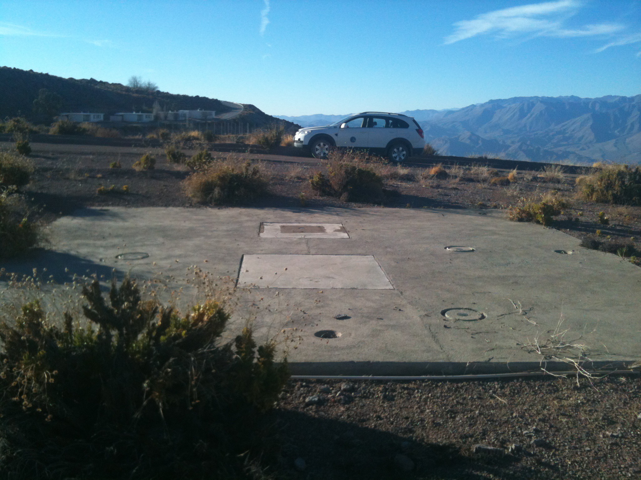
5.2.1 Tololo Control Monument
A survey monument called “Tololo”, “Tololo Control”, or “O” on the 1960s/1970s-era notes and survey maps of Cerro Tololo lies just southeast of the Blanco 4-m dome structure, just outside of the guard rail girding the gravel (see Fig. 6). In Table 5, I list several estimates of the elevation of the Tololo Control survey monument. An elevation of 2211.60 m above sea level is listed on a surveying note from the Kitt Peak National Observatory Engineering Dept. This benchmark was used in conjunction with monuments on other nearby peaks (Pachón, Morado, etc.) for tying in the position of Tololo with the cartographic grid used by the Instituto Geographico Militar de Chile and Chilean Air Force in the 1960s (the Chile Plane Coordinate System)252525The monument disk states “Instituto Geographico Militar de Chile - destruccion penada por la ley”.. The elevation of this monument defined the elevation scale for other structures built on the Tololo plateau, as marked in the 1973 survey map (see Table 2). GPS measurement of the elevation of the Tololo monument yielded 2222 m. The 2008 survey discussed in §3.4 measured a geodetic elevation of 2242.493 m with respect to the GRS 80 ellipsoid (which is within tens of micrometers of the WGS 84 ellipsoid). The monument is not obvious on Google Earth imagery, however the elevation in the vicinity of the monument is 2201 m.
| Source | Elevation | Notes |
|---|---|---|
| (m) | ||
| 1973 survey | 2211.60 m | “mean sea level” |
| 2008 survey | 2242.493 m | w/r GRS 80 ellipsoid (no geoid) |
| Google Earth | 2201 m | w/r WGS 84 ellipsoid + EGM96 geoid |
| GPS | 2222 m | w/r WGS 84 ellipsoid + unknown geoid |
The 2008 survey measurement for the Tololo Control survey marker is the most accurate WGS 84 coordinate position, and fortunately its datum is unambiguous (GRS 80 WGS 84). The GPS elevation is 20 m lower than the 2008 geodetic survey elevation. The Google Earth elevation is 10 m lower yet, however Google Earth measures elevations with respect to the EGM-96 geoid, which accounts for most of the 41 m discrepancy. The level of disagreement among the elevations is somewhat surprising, however, given the good agreement for the elevations measured for the NASA monument near the SARA South observatory.
5.2.2 Treatment of Elevation Data
Multiple series of GPS measurements were taken of a few sites on different days. From comparing average GPS elevation measurements taken on different days, it is clear that significant systematic errors in the GPS elevations are present at the 5 m rms level (presumably from having data from different satellites participate in the solution). This precludes using the standard error of the mean for measurements taken during a short interval on a given day as a useful measure of the uncertainties.
Inter-comparison of the GPS and Google Earth elevations reveals a systematic offset:
| (6) |
The rms scatter was 8.6 meters. The source of the discrepancy is unclear. Two likely possibilities are that either (1) the 3” resolution of the Google Earth elevation data from SRTM has smoothed over the high elevation points (where many of the telescopes are located), or (2) there may be a difference in the geoid adopted in the GPS calculations and that used by Google Earth (EGM96). Both the GPS and Google Earth elevations are clearly limited in their accuracy. The GPS measurements often have epoch-to-epoch jumps and the datum is ambiguous (at the time of writing, there is conflicting literature on the web regarding this; whether Garmin GPSs measure with respect to the ellipsoid, or whether they include a geoid model). The Google Earth maps have excellent imagery resolution, but the elevation maps are limited to the SRTM resolution (3”). Unfortunately, elevations taken both with the handheld GPS unit and via Google Earth must both be taken with a grain of salt. The best elevations that we have available are those from the 2008 survey and those for a NASA geodetic monument.
For useful comparison of the elevations, it was decided to place all measurements on the same elevation system defined by the 2008 theodolite survey (which includes very accurate elevations measured with respect to the GRS 80 [WGS 84] ellipsoid). Through inter-comparison of the measured elevations, I decided to correct GPS, Google Earth, and 1973 survey elevations to the geodetic elevation system defined by the 2008 survey (close enough to WGS 84 to be practically considered WGS 84):
| (7) |
| (8) |
| (9) |
The difference between the Google Earth elevations and the 2008 survey geodetic heights are close enough to the EGM-96 geoid undulations (38 3 m; see actual EGM-96 values in Table 6), that they appear to provide useful elevations . The difference between the GPS elevations and 2008 survey heights do not appear to correspond to either zero (if the GPS elevations were actually geodetic heights), or any of the widely used geoid undulations. Hence, I simply add a constant to the GPS elevations and place them on the WGS 84 geodetic height scale. The difference between the 2008 survey geodetic heights and the 1973 survey elevations (31.3 m) is remarkably similar to the geoid undulation heights (§2; especially for the WGS 84 ellipsoid), suggesting that the zero point for the 1973 survey elevations is indeed within a few meters of recent geoid models.
6. Conclusions
Best estimates for the geodetic and geocentric positions of the observatories on Cerro Tololo and Cerro Pachón are listed in Table 6. Final elevations taking into account the offsets in elevations discussed in the last section are also included, along with geoid undulation heights based on the EGM-96 model.
It appears that using Google Earth one can derive geodetic WGS 84 coordinates for observatories and structures to approximately 0”.15 (5 m) accuracy in latitude and longitude without resorting to more accurate techniques (i.e. GPS, surveying). Google Earth shows systematic shifts in position between imagery epochs at the 0”.1 level (3 m). Positions measured on the most recent Google Earth imagery of Cerro Tololo and Pachón reveal slight systematic offsets with respect to GPS-derived positions at the 0”.1 (3 m) level, which can be corrected for if necessary. The rms scatter in positions derived via GPS and Google Earth is approximately 0”.14 (4 m). Treating the GPS and Google Earth positions as independent estimates, and correcting the Google Earth positions for small systematic differences at the 0”.1 (3 m) level, one can derive final mean positions for structures on Cerro Tololo and Pachón with absolute accuracy 0”.1 (3 m). One can obviously do better if needed through long integrations of GPS determinations, or theodolite observations tied to monuments with well-constrained geodetic positions, however this would obviously require more time and money (which always seem to be in short supply).
While astronomical coordinates have not been determined for all of the observatories on Cerro Tololo and Cerro Pachón (an arduous task), one can derive approximate astronomical coordinates by adding an offset derived from Harrington et al.’s (1972) observations:
| (10) |
| (11) |
However this is only a rough approximation as no doubt the vertical deflection due to the gravity field varies subtly over the two peaks.
Besides the obvious (and explainable) disagreement between the geodetic and astronomical positions for Cerro Tololo (§3.2), there was at least one other surprise in comparing the final positions in Table 6 with the previously published positions in Table 1. An often quoted position for LSST listed in two recent LSST documents (Ivezic et al., 2008a, b) appears to be in error by 9.4 km ( = 260”.6, = 60.0”), and by 500 m in elevation (2123 m listed vs. 2600 m measured). The position listed in Ivezic et al. (2008a) and Ivezic et al. (2008b) appears to correspond most closely to the NASA survey monument on Cerro Tololo (rather than Pachón). The position for the LCOGT observatories on Tololo on the LCOGT website appear to be in error by 0.2 km. Our position for Gemini South agrees with the value on their website262626http://www.gemini.edu/sciops/telescopes-and-sites/locations to better than 0”.04 for each axis (within 1 m), and our GPS estimate of the elevation (2722 m) is identical to their value.
After finding that some of the published positions for observatories on Cerro Tololo and Cerro Pachón were erroneous, it may be worth the time to double-check the published positions of other observatories (especially if those observatories pre-date the GPS era). Using erroneous positions for observatories can lead to unnecessary systematic errors in various position-dependent astronomical calculations, which are inexcusable in the era of GPS and Google Earth.
References
- Allenby (1984) Allenby, R. J. 1984, Andean Tectonics: Implications for Satellite Geodesy, NASA Technical Memorandum 86160, Goddard Space Flight Center, September 1984.
- Blanco & Mayall (1972) Blanco, V. M. & Mayall, N. U. 1972, Bulletin of the American Astronomical Society, Vol. 4, 66–97
- Buie et al. (2012) Buie, M. W., Wasserman, L. H., Vaduvescu, O., Holmes, R., & Linder, T. 2012, Minor Planet Circulars, 79528, 6
- Elliot et al. (1981) Elliot, J. L., Frogel, J. A., Elias, J. H., Glass, I. S., French, R. G., Mink, D. J., & Liller, W. 1981, AJ, 86, 127
- Farr et al. (2007) Farr, T. G., Rosen, P. A., Caro, E., et al. 2007, Reviews of Geophysics, 45, 2004
- French et al. (1983) French, R. G., Elias, J. H., Mink, D. J., & Elliot, J. L. 1983, Icarus, 55, 332
- Hamuy et al. (1996) Hamuy, M., Phillips, M. M., Suntzeff, N. B., Schommer, R. A., Maza, J., & Aviles, R. 1996, AJ, 112, 2391
- Harrington et al. (1972) Harrington, R. S., Mintz Blanco, B., & Blanco, V. M. 1972, Contributions of the Cerro Tololo Inter-American Observatory No. 126: Geodetic and Astronomical Coordinates of the Cerro Tololo Inter-American Observatory
- Hofmann-Wellenhof et al. (1992) Hofmann-Wellenhof, B., Lichtenegger, H., & Collins, J. 1992, Global Positioning System (GPS). Theory and practice
- Hubbard et al. (1997) Hubbard, W. B., Porco, C. C., Hunten, D. M., et al. 1997, Icarus, 130, 404
- Ivezic et al. (2008a) Ivezic, Z., Axelrod, T., Brandt, W. N., et al. 2008a, Serbian Astronomical Journal, 176, 1
- Ivezic et al. (2008b) Ivezic, Z., Tyson, J. A., Acosta, E., et al. 2008b, ArXiv e-prints, ArXiv:0805.2366
- Lasker et al. (1973) Lasker, B. M., Bracker, S. B., & Kunkel, W. E. 1973, PASP, 85, 109
- Mayall (1968) Mayall, N. U. 1968, PASP, 80, 37
- Perlmutter et al. (1999) Perlmutter, S., Aldering, G., Goldhaber, G., et al. & Supernova Cosmology Project. 1999, ApJ, 517, 565
- Riess et al. (1998) Riess, A. G., Filippenko, A. V., Challis, P., et al. 1998, AJ, 116, 1009
- Schmidt et al. (1998) Schmidt, B. P., Suntzeff, N. B., Phillips, M. M., et al. 1998, ApJ, 507, 46
- Schwab et al. (2010) Schwab, C., Spronck, J. F. P., Tokovinin, A., & Fischer, D. A. 2010, in Society of Photo-Optical Instrumentation Engineers (SPIE) Conference Series, Vol. 7735, Society of Photo-Optical Instrumentation Engineers (SPIE) Conference Series
- Seidelmann (1992) Seidelmann, P. K. 1992, Explanatory Supplement to the Astronomical Almanac (University Science Books)
- Simms et al. (2005) Simms, L., Burke, D., Claver, C. F., et al. 2005, in Bulletin of the American Astronomical Society, Vol. 37, American Astronomical Society Meeting Abstracts, 1206
- Smith et al. (1994) Smith, D. E., Kolenkiewicz, R., Nerem, R. S., Dunn, P. J., Torrence, M. H., Robbins, J. W., Klosko, S. M., Williamson, R. G., & Pavlis, E. C. 1994, Geophysical Journal International, 119, 511
- Tapley et al. (1985) Tapley, B. D., Schutz, B. E., & Eanes, R. J. 1985, Celestial Mechanics, 37, 247
- U. S. Government Printing Office (2013) (USGPO) U. S. Government Printing Office (USGPO). 2013, The Astronomical Almanac for the year 2013
- Vilas & Lasker (1977) Vilas, F. & Lasker, B. M. 1977, PASP, 89, 95
- Walker & Muñoz (1980) Walker, A. R. & Muñoz, J. 1980, Facilities Manual of the Cerro Tololo Inter-American Observatory (CTIO)
- Zombeck (2007) Zombeck, M. 2007, Handbook of Space Astronomy and Astrophysics: Third Edition (Cambridge University Press)
Updates
4 Oct 2012: Posted to arXiv: http://xxx.lanl.gov/abs/1210.1616
9 Oct 2012: Minor edits. Added hyperlinks for all websites. Added Google Maps hyperlinks for all coordinates listed in
Tables 1, 4, and 6. Table 6: Added table notes. Added footnote on LSST floor elevation. No numbers were changed.
1 Mar 2013: Slight revisions for elevations for Gemini and SOAR in Table 6, with explanations added in table notes and . Minor revisions to text in Introduction.
Cerro Tololo and Cerro Pachón
| Site | Ref. | ||||||||||||
|---|---|---|---|---|---|---|---|---|---|---|---|---|---|
| ’ | ” | ’ | ” | (m) | (m) | (m) | ’ | ” | |||||
| Cerro Tololo | |||||||||||||
| Blanco 4-m | -30 | 10 | 10.78 | -70 | 48 | 23.49 | 1 | 2241.4a | 34.6 | 2206.8a | -30 | 00 | 10.03 |
| SMARTS 1.5-m | -30 | 10 | 09.42 | -70 | 48 | 24.44 | 1 | 2241.9a,b | 34.6 | 2207.3a,b | -30 | 00 | 08.68 |
| SMARTS 1.0-m | -30 | 10 | 07.92 | -70 | 48 | 21.83 | 1 | 2240.5a | 34.6 | 2205.9a | -30 | 00 | 07.18 |
| SMARTS 0.9-m | -30 | 10 | 07.90 | -70 | 48 | 23.86 | 1 | 2241.4a | 34.6 | 2206.8a | -30 | 00 | 07.16 |
| Curtis Schmidt 0.6-m | -30 | 10 | 08.60 | -70 | 48 | 22.63 | 1 | 2240.9a | 34.6 | 2206.3a | -30 | 00 | 07.86 |
| Former UCAC | -30 | 10 | 06.95 | -70 | 48 | 22.82 | 1 | 2241.2a | 34.6 | 2206.6a | -30 | 00 | 06.21 |
| Former CHASE | -30 | 10 | 06.97 | -70 | 48 | 21.65 | 1 | 2240.5a | 34.6 | 2205.9a | -30 | 00 | 06.23 |
| RASICAM | -30 | 10 | 08.03 | -70 | 48 | 25.11 | 1 | 2238a | 34.6 | 2204a | -30 | 00 | 07.29 |
| WHAM | -30 | 10 | 05.92 | -70 | 48 | 12.85 | 1 | 2188c,d | 34.7 | 2153c,d | -30 | 00 | 05.18 |
| KASI | -30 | 10 | 01.84 | -70 | 48 | 14.39 | 2 | 2182c,d | 34.7 | 2147c,d | -30 | 00 | 01.12 |
| LCOGT Stellan-A | -30 | 10 | 02.58 | -70 | 48 | 17.24 | 1 | 2198c,d | 34.6 | 2163c,d | -30 | 00 | 01.85 |
| LCOGT Stellan-B | -30 | 10 | 02.39 | -70 | 48 | 16.78 | 1 | 2198c,d | 34.6 | 2163c,d | -30 | 00 | 01.66 |
| LCOGT Stellan-C | -30 | 10 | 02.81 | -70 | 48 | 16.85 | 1 | 2198c,d | 34.6 | 2163c,d | -30 | 00 | 02.08 |
| SMARTS 1.3-m | -30 | 10 | 02.81 | -70 | 48 | 17.92 | 1 | 2200c,d | 34.6 | 2165c,d | -30 | 00 | 02.08 |
| PROMPT #1 | -30 | 10 | 03.52 | -70 | 48 | 18.91 | 3 | 2207c,d | 34.6 | 2172c,d | -30 | 00 | 02.79 |
| PROMPT #2 | -30 | 10 | 03.49 | -70 | 48 | 19.56 | 3 | 2207c,d | 34.6 | 2172c,d | -30 | 00 | 02.76 |
| PROMPT #3 | -30 | 10 | 03.17 | -70 | 48 | 18.85 | 3 | 2207c,d | 34.6 | 2172c,d | -30 | 00 | 02.44 |
| PROMPT #4 | -30 | 10 | 03.56 | -70 | 48 | 19.32 | 1 | 2207c,d | 34.6 | 2172c,d | -30 | 00 | 02.83 |
| PROMPT #5 | -30 | 10 | 03.16 | -70 | 48 | 19.16 | 3 | 2207c,d | 34.6 | 2172c,d | -30 | 00 | 02.43 |
| PROMPT #6 | -30 | 10 | 03.82 | -70 | 48 | 18.96 | 3 | 2207c,d | 34.6 | 2172c,d | -30 | 00 | 03.09 |
| PROMPT #7 | -30 | 10 | 04.33 | -70 | 48 | 19.36 | 1 | 2208c,d | 34.6 | 2173c,d | -30 | 00 | 03.60 |
| GONG | -30 | 10 | 03.92 | -70 | 48 | 19.84 | 1 | 2209c,d | 34.6 | 2174c,d | -30 | 00 | 03.19 |
| SSI Airglow | -30 | 10 | 05.28 | -70 | 48 | 19.56 | 1 | 2212c,d | 34.6 | 2177c,d | -30 | 00 | 04.55 |
| T80-South (site) | -30 | 10 | 04.31 | -70 | 48 | 20.48 | 2 | 2212c,d | 34.6 | 2178c,d | -30 | 00 | 03.58 |
| SARA South 0.6-m | -30 | 10 | 19.72 | -70 | 47 | 57.13 | 1 | 2151c,d | 34.7 | 2116c,d | -30 | 00 | 18.93 |
| Cerro Pachón | |||||||||||||
| Gemini South 8.2-m | -30 | 14 | 26.67 | -70 | 44 | 12.06 | 1 | 2748e | 35.1 | 2713e | -30 | 04 | 25.12 |
| SOAR 4.1-m | -30 | 14 | 16.41 | -70 | 44 | 01.11 | 1 | 2738f | 35.1 | 2703f | -30 | 04 | 14.89 |
| LSST 8.4-m (site) | -30 | 14 | 40.68 | -70 | 44 | 57.90 | 2 | 2647g | 35.0 | 2612g | -30 | 04 | 39.07 |
| LSST Aux. 1.4-m (site) | -30 | 14 | 41.27 | -70 | 44 | 51.80 | 2 | 2647g | 35.0 | 2612g | -30 | 04 | 39.66 |
| Andes LIDAR Obs. (ALO) | -30 | 15 | 06.37 | -70 | 44 | 17.50 | 1 | 2552c,d | 35.1 | 2517c,d | -30 | 05 | 04.67 |
Note. — Coordinate reference codes: (1) average of GPS and corrected Google Earth positions, (2) GPS position, (3) corrected Google Earth position. Geodetic latitude , longitude on WGS 84 system. Geodetic elevation is with respect to the WGS 84 ellipsoid. Elevation is orthometric height with respect to geoid (i.e. above “mean sea level”; = - ). is geoid undulation according to EGM-96 model, i.e. it is the height of the geoid above the WGS 84 reference ellipsoid. Geocentric latitude was calculated following §4 of Seidelmann (1992). Total uncertainties in latitude and longitude are approximately 0”.10. Elevations are ground level at the site, not the elevation of the telescope.