A review of EO image information mining
Abstract
We analyze the state of the art of content-based retrieval in Earth observation image archives focusing on complete systems showing promise for operational implementation. The different paradigms at the basis of the main system families are introduced. The approaches taken are considered, focusing in particular on the phases after primitive feature extraction. The solutions envisaged for the issues related to feature simplification and synthesis, indexing, semantic labeling are reviewed. The methodologies for query specification and execution are evaluated. Conclusions are drawn on the state of published research in Earth observation (EO) mining.
keywords:
Remote sensing, Content-Based Image Retrieval1 Introduction
Earth observation (EO) archive volumes are slowly approaching the zettabyte scale. The assets they contain are largely under-exploited: the majority of records have never been accessed. The situation is exacerbated by the growing interest in and availability of metric and submetric resolution sensors, due to the ever-expanding data volumes and the extreme diversity of content in the imaged scenes at these scales. Data from missions such as the ESA Sentinels will be open and free, thus a much larger audience will want to use them. Interpreters to manually annotate archived content are expensive and tend to operate in applicative domains with stable, well-formalized requirements (e.g. the military) rather than on the open-ended needs of the remote sensing community at large or of broad efforts like GEOSS (King et al., 2011).
Semi-automatic tools to analyze, label, summarize the contents of the archived image products need to be rendered a standard component of payload ground segments.
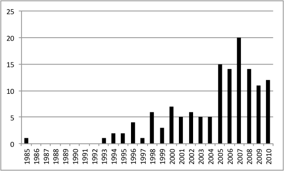
Development is currently very active in this domain. Workshops like the ESA-EUSC-JRC IIM Workshop (http://rssportal.esa.int/tiki-index.php?page=2011_ESA-EUSC-JRC) are organized to discuss about the state of the art in Earth observation information retrieval. Special issues of Journals such as the IEEE Transactions on Geoscience and Remote Sensing have been dedicated to the topic (Datcu et al., 2007, 2010). Advanced, specialized problems related e.g. to object–based mining methodologies have been the subject of a number of contributions on publications such as the ISPRS Journal of Photogrammetry & Remote Sensing. The present work analyzes more than one hundred references with global geographical representation and whose temporal distribution is represented in the plot in figure 1.
In the US, both research oriented systems and operational tools are under active development. The first category includes tools like the I3KR at the Mississippi State University (King et al., 2007) and VIS-STAMP at the University of South Carolina (Guo, 2003). The second one comprises VisiMine (Tusk et al., 2003), Insightful GeoBrowse (Marchisio et al., 1998), Earth Perspective’s GeoIRIS (Shyu et al., 2006) and the RBIR system at Oak Ridge National Laboratory (Tobin et al., 2006).
European activity in the domain is rich and diverse. It is embodied in systems such as ESA KIM (Schröder et al., 2000) (Datcu et al., 2002), KEO (Datcu et al., 2003) IIM-TS (Bovolo and Bruzzone, 2007), installed at ESA, DLR, CNES and MEA (Mantovani et al., 2009), in the Finnish prototype (Molinier et al., 2007b) based on PicSOM system developed at Aalto University and in SemQuery (Sheikholeslami et al., 2002), in the french PLATO (Rital et al., 2008), the italian Centro Nazionale Multi-missione/Data Mining component at ASI (Garramone, 2009) and in the upcoming TELEIOS EO virtual observatory (http://www.earthobservatory.eu/) and in the ESA/DLR EOLib connected directly to the Sentinel payload ground segments among others.
The Brazilian GeoDMA (Korting et al., 2008; Pahl, 2008) is currently constrained to the analysis of limited datasets, yet shows promise for contexts involving larger data volumes. A further interesting component is TerraLib (Camara et al., 2008), an open-source GIS software library that handles spatio-temporal data types (events, moving objects, cell spaces, modifiable objects) and allows spatial, temporal and attribute queries on the database, providing functions for data conversion, display, exploratory spatial data analysis and spatial and non-spatial queries.
Activity in the Asia and Pacific region is represented by innovative prototype systems such as those in (Ruan et al., 2006) and (Li and Bretschneider, 2007).
In the face of all of these research and development efforts, archive owners and operators are attempting a rapid transition to operational systems for automatic data annotation connected directly to satellite payload ground segments. Different options are available among architectures and paradigms for pre-operational Earth Observation digital asset management systems, data structures and algorithms. In this paper, we conduct a critical analysis of the state of the art in this domain, specifically focusing on validated approaches aiming at operational exploitation, in the hope of providing a contribution to this transition.
This work is structured as follows: section 2 describes the review methodology. In section 3, a basic abstract description of an EO mining system is used to derive a decomposition of its functionality into modules. The next sections analyze in detail the different choices taken with respect to specific processing steps: section 4 describes query specification and processing, section 4.5.1 the indexing approaches, and section 5 the data ingestion and autonomous analysis. Section 6 reports a general discussion of the review results.
2 Review methodology
The assessment of the state of the art in EO data mining has involved discovering, aggregating, normalizing and analyzing new material to a pool of bibliographic sources in different iterations.
The original sources considered have included the journals and the proceedings of the conferences and workshops mentioned in section 1. Items relevant to the query ‘(Earth observation OR remote sensing) AND (data mining OR content based retrieval)’ according to the arXiv at the Cornell University Library (http://www.arxiv.org/), Google Scholar (http://scholar.google.com/), Mendeley (http://www.mendeley.com/) and Zotero (http://www.zotero.org/) have constituted primary material as well. Progressive aggregations have included material cited by these sources. A further significant source of material has been constituted by exploring publications citing the papers in the pool via the above literature search tools and Google Scholar in particular.
The analysis of the characteristics of the pooled material by objective means has been an important methodological point of the conducted analysis.
Inspired by Guns et al. (2011) and Giuliani et al. (2010), the metadata describing the considered references have been analyzed by developing a toolset to build a graph representation of the co-authorship relations among their authors. The representation obtained by this analysis process has been manipulated in the open source Gephi (Bastian et al., 2009) system (https://gephi.org/) to obtain the graph map depicted in figure 2. In it, nodes correspond to single authors. Their sizes are proportional to the number of authored publications in the references pool, while edges, representing co-authoring relationships, are weighted proportionally to the considered joint publication number.

The graph representation has then been subjected to a Yifan-Hu layout optimization procedure (Hu, 2005).
The immediately apparent clustering resulting in the figure actually corresponds to the main EO system families represented in the considered literature: framework names in larger bold letters have been added to the diagram for readability. The characteristics of the main families of systems in operation are summarized together with a description of their architectures into essential subsystems in tables 1 and 2.
| System | Original Implementation | References |
|---|---|---|
| GeoBrowse | Insightful Corp. | Marchisio et al. (1998) |
| GeoIRIS | University of Missouri | Shyu et al. (2007) |
| I3KR | Mississippi State University | Durbha and King (2005) |
| KEO | DLR and ACS | Datcu et al. (2003) |
| RBIR | ONRL | Tobin et al. (2006) |
| PicSOM | Aalto University & VTT | Molinier et al. (2007a) |
| MEA | MEEO | Natali et al. (2011) |
| System | GeoBrowse | GeoIRIS | I3KR | IIM/KIM/KEO/IIM-TS | RBIR | PicSOM | MEA |
| Sensor | Multi-spectr | Multi-spectr | Multi-spectr | Multi-spectr | Multi-spectr | Multi-spectr | Multi-spectr |
| classes | SAR, Time Series | SAR, Time Series | |||||
| Res. scale (m) | 10 | 1 | 10 | 1-10 | 1 | 1-10 | 10 |
| User interface | Desktop app | WebUI + Google | WebUI | Java-based desktop | Desktop app | Unreported | Web UI |
| Earth invocation | Graphical UI | ||||||
| Search | Interactive | Example patch; | Semantics; | +/- example pts; | Example | Example | Example |
| paradigm | data | extracted obj. attribs; | metadata; | text semantic label | patches | patches | area |
| exploration | multi-object; semantic | examples | |||||
| Spectral | Yes | Yes | Yes | 256 classes | Yes | RGB average | |
| Texture | Yes | Haralick | Wavelets | Gauss–Markov Fields | Limited | Gabor | |
| Shape | Yes | Yes | Zernike on shapes | Edge histograms | Edge histograms | ||
| Object | Yes | ||||||
| Specialized | Anthropogenic | User pluggable | NDVI | Stratified 56cl. | |||
| Multi-temp. | Seasonal trends | ||||||
| trajectory | |||||||
| Multi-object | Yes | Yes | Pluggable extractors | ||||
| Clustering | S-PLUS | Entropy-balanced | Kernel PCA + | K-Means | Geospatial | ||
| statistical environ. | Trees | Support Vector Machines | clustering | ||||
| User labelling | Sigmoid functions | Description Logics | Bayesian classifier | Self-organizing | Nearest Neighbor | ||
| Query | Informix | Entropy Balanced | Sequential DB scan | K-dimens. tree | map baed on | DB index | |
| data blade | Tree scan | with optimized comp. | neural network | ||||
| of probability index |
3 System description and decomposition
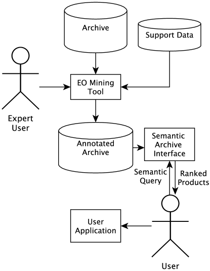
A few assumptions can be made in order to characterize the nature of an EO mining system and of its operating domain (figure 3).
-
1.
The system runs on very large (petabyte) scale data base archives. Accessible data and metadata are available for the archived products.
-
2.
External support datasets are also often available, from pre-existing vector maps to information from additional sensors, and might in principle be used e.g. via data fusion methodologies.
-
3.
The main goal of an EO mining system is to help efficiently discover, annotate and retrieve specific data products in the archive based on a semi–automatic characterization of their contents / of the contents of the scenes they represent.
-
4.
The overall objective of this capability is to provide support to environmental understanding activities such as rapid mapping for disaster management, decision support for planning in large scale engineering, global climate change mapping.
-
5.
Additional important overall objectives are those related to the management and monitoring of the archive and of the whole remote sensing system.
To achieve the final goal of EO archive-wide semi-automatic content discovery, annotation and retrieval, the methodologies envisioned by the EO mining systems described in the considered literature references vary from rapid mapping to archive navigation. Image processing and analysis, data mining, geographic data management, object detection and recognition methodologies are relevant, yet need to be adapted and combined in order to allow characterizing vast volumes of unknown — and at metric scales at least essentially uncategorizable — content. System structures and algorithmic choices vary significantly as well, from the considered signal characteristic primitive feature descriptors to data indexing approaches, from strategies for the optimization of specific needs for efficient storage access to supervised semantic label learning and ontology management. Yet in general we can assume that, in terms of functionality, an EO mining system
-
1.
at ingestion time, automatically characterizes the input items based on a set of characteristics of their data and metadata contents that provide a basis — the primitive feature descriptors — for all further analysis;
-
2.
semi–automatically annotates the files in an EO archive based on their content and metadata. Annotation happens either in terms of semantic classes (e.g. ‘bridge’, ‘house’) or in terms of application-independent content descriptors (‘spectral’, ‘shape’) – allowing feature synthesis (e.g. mixing spatial/geographic and content descriptors) and data fusion (e.g. existing geographical maps with EO products);
-
3.
indexes input item sets, building data structures that allow an efficient representation of their content for the content discovery, annotation and retrieval aims of point 3 above.
The above points have consequences that are ubiquitous on the design and evaluation of EO mining systems. For instance, it has to be noted that all considerations related to efficiency in the remainder of this paper refer to query performance rather than optimized storage, as is typical in OLAP schemes (Chaudhuri and Dayal, 1997).
3.1 Abstract system model
According to Manning et al. (2009), the Information Retrieval (IR) problem can be stated as the maximization of a certain utility that ranks visual documents for a user in a specific context. Describing (long term) user interests about visual information is crucial to the performance of IR systems. To that end, relevance can be expressed explicitly via a rating scale. For example, the binary scale can be used to express “dislike”/“like” or “rejection”/“acceptance” preferences. Alternatively, a “five stars” scale such as the one used by Amazon (http://www.amazon.com/) allows the users to give more detailed degrees of appreciation. A Bayesian probability scale can be used to express degrees of belief in the statement “data archive item X is interesting to user Y in the operative and spatio–temporal context Z” (Jaynes, 2003). Again in Bayesian terms, semantic analysis and annotation in the context of EO data mining can therefore be understood as the procedure of finding the semantic scene elements / the labels that best describe a given dataset in a given operative scenario.
We note that this way of expressing the characteristic functionality of an EO mining tool relates its operation to that of a scene understanding tool performing inference and estimation on the inversion of a direct data acquisition model.
When models for the scene and the data become so complicated that the inversion becomes intractable, a common solution is a divide-and-conquer approach in which simpler intermediate description levels are introduced in the modeling. The scene is then assumed to be related to the data through more levels of intermediate simpler models that are logically linked
| direct modelling | |||
| undestanding and retrieval |
The learning is in this case performed across levels to derive a conclusion about the underlying scene.
The generic model corresponding to the treatment given for instance in the content-based image retrieval review paper by Smeulders et al. (2000) can be adapted to the context of EO and represented as
| (1) |
where
-
1.
represents the available data
-
2.
represents a normalized version of , ready for ingestion
-
3.
represents some form of partitioning of
-
4.
describes a set of primitive features for the objects in
-
5.
is a set of signs directly extracted from the normalized data
-
6.
is a joint indexing of the features and the signs
-
7.
represents a generic abstract classification of the data represented by the index
-
8.
is a description of the original scene content in terms of semantic classes.
The way this model architecture translates into algorithmic components is determined by the system architecture.
3.2 Architectural options

A general decomposition of a theoretical query process is depicted in figure 4. Archived products can be subject to weak and strong segmentation processes as well as to a simple partitioning from which regions are extracted. These regions are then subject to primitive feature extraction, an unsupervised data analysis step that generates signatures in metric spaces that express signal characteristics. Well-known scene elements (“signs”) can be handled by direct detection and characterization. In the case of EO, these signs correspond to characteristic elements of specific interest such as for example road networks and simple classes of buildings such as silos. Concurrently, a preliminary selection of an archive collection of interest and of an appropriate system configuration can lead to the specification of a query. This query is formulated in such a way as to be usable for computing similarities in terms of the primitive descriptors to the analyzed archive datasets. The ranked results can then be manipulated by supervised techniques (e.g. including relevance feedback supervision loops) in order to be used to synthesize labels that can later be used to enrich the archive contents with semantic descriptions.
While the above represents a general view of the operation of an EO mining tool, most of the systems are based on a broad subdivision between an ingestion component that analyzes the data in an autonomous manner (data discovery and normalization, primitive feature extraction, indexing), a learning component that is able to link the primitive feature information with semantic classes (supervised labeling) and a query processing system that computes image-to-label and pixel-to-label distances.
The way these main stages are implemented and connected with each other in actual systems defines their high level architecture.
KEO (Datcu et al., 2003) is composed of a number of separate servers with SOAP interfaces for much of the communication both among them and with the user interface. System web services and interfaces are orchestrated by the Oracle BPEL Process Manager, to ensure the correct data flow between modules (Munoz and Datcu, 2010).
GeoBrowse (Marchisio et al., 1998) is based on abstract services and distributed objects. Its operation is based on the functionality of an object-relational database management system and of a scientific problem solving environment, S-PLUS. Communication between its various components can be established across platforms and the Internet.
Alternative approaches are also represented. The RBIR system in Tobin et al. (2006), for instance, breaks down into three components: (a) a software agent-driven process that can autonomously search through distributed image data sources to retrieve new and updated information, (b) a geo-conformance process to model the data for temporal currency and structural consistency to maintain a dynamic data archive, and (c) an image analysis process to describe and index spatial regions representing various natural and man-made cover types. Again, the different components are interconnected by web services with well specified interfaces.
Moving from architectural descriptions to algorithmic choices, we now start analyzing in detail the different choices taken with regards to specific elements of an EO mining system. With respect to Smeulders et al. (2000), we prefer conducting the review in reverse order, starting with the intended final user operations, since we hope this to better clarify the different possible tradeoffs.
4 Query specification and processing
Different approaches exist regarding how a data mining tool for EO should operate from the point of view of the final user with the aim of fulfilling the objectives of retrieving datasets of interest and characterizing them introduced in section 1. In Peijun et al. (2005), five retrieval patterns are proposed for EO including template-based, attribute-based, metadata-based, semanteme-based and integrated retrieval.
-
1.
Retrieval based on metadata (e.g. aquisition time, swath localization, sensor type). Although this paradigm is not the central subject of this review, it needs to be understood as a powerful basis for effective browsing and retrieval, e.g. contributing to methodologies such as those related to faceted search (see below).
-
2.
Retrieval based on the explicit specification of query attributes. In this approach, the query details a series of relevant attributes that can be extracted from the content of the data items in the searchable base. Examples might include both application–independent (e.g. color intervals) and specific descriptors (e.g. Normalized Difference Vegetation Index – NDVI values).
-
3.
Retrieval based on a template. A user–provided sketch of the geometry of the elements of interest or a (possibly multi–polygon) relevance mask on a set of existing image items or even full image examples are provided as a query description. A query analysis subsystem analyzes the templates generating a description that can be generalized and compared with corresponding descriptions extracted at ingestion from the items in the searchable data base.
-
4.
Retrieval based on semantemes, or minimal distinctive units of meaning, as opposed to sememes, the lower–level units of meaning carried by a morpheme that can be considered at the basis of the former query specification approaches. According e.g. to Smeulders et al. (2000), a semantic gap needs to be taken into account representing the lack of coincidence between the information that one can extract from the visual data and the interpretation that the same data have for a user in a given situation in linguistic, keyword–based, contextual terms. The semantic gap has its source in the fact that in content-based retrieval is that the user seeks semantic similarity, but the database can only provide similarity by data processing. The challenge for image search engines — especially for those designed to operate on a broad domain — is to tailor the engine to the narrow domain the user has in mind via specification, examples, and interaction, effectively creating the relationship between semantic information and quantitative descriptions of EO signals.
-
5.
Integrated retrieval approaches, in which the complementary strenghts of the above methodologies can be combined in order to express complex information needs.
4.1 Interaction patterns
In practice, these query specification methodologies map to elements of the user interface and interaction patterns.
-
1.
Query by textual semantic label: the user inputs a textual description of the scene contents that are being sought.
-
2.
Query by similarity: the user provides visual examples of the elements being queried. The examples can be pixel-based (the user interface allows single clicks to be provided), region-based (the user can draw polygons around areas of interest) or tile-based (the input products are cut into image tiles with limited size, each of which can be used as an example). A further possibility is query-by-sketching, in which the user draws a simple outline of the elements of interest. The examples can belong to a single class or to multiple different classes that are considered contextually. Furthermore, some systems allow the user to provide both positive and negative examples for each class.
-
3.
Metadata–based faceted search: A faceted classification system combines data search and browsing by classifying each information element along multiple explicit dimensions: the user can specify complex queries on the parameter space by applying multiple filters to explore the query result collection. For instance, a dataset might be reduced to a small set of interesting items by interactively exploring the results of filtering it with multiple metadata– (e.g. GeoTIFF files only) and content–based (e.g. only products containing urban areas) criteria. This search paradigm might be implemented in a tree–structured browsing interface showing a synthetic statistical description (e.g. the current cardinality) of the currently selected product set (Ben-Yitzhak et al., 2008), while allowing the user to further filter it, as in the Amazon “Browse Books” catalogue interface (http://www.amazon.com/).
Actual systems mix the different approaches in order to allow users to express the semantics of the applicative domains they focus on.
KIM/KEO (Schröder et al., 2000; Datcu et al., 2003) pre-analyzes all input products, yet the user can in a later phase interactively define new cover classes of interest based on positive and negative example product regions. The classification is only used to provide visual feedback in the training phase. The obtained semantic labels are naturally extended to the whole archive, used for ranking search results and to generate classification maps on selected products. Systematic processing for classification map generation on large dataset is also supported.
PicSOM (Molinier et al., 2007a) implements query by visual examples, with a relevance feedback loop for the interactive learning of user–level semantics.
GeoIRIS (Shyu et al., 2007) supports query by example (possibly limited by region surrounding geographic and anthropogenic features), object and multiobject spatial relationship queries as well as semantic queries to answer information needs such as “given a query image, show me a set of satellite images that depict objects and spatial relationship that are similar to those in the query and that are located within a certain radius of a landmark.” Klaric et al. (2006) and Shyu et al. (2006, 2007) propose bridging the semantic gap by a three-step process composed of data transformation (each continuous feature is partitioned into multiple discrete ranges that are meaningful for a specific semantic), mining associations (association rules map feature intervals into semantic categories) and semantic modeling in which crisp intervals from association rules are replaced by sigmoid functions (Barb and Shyu, 2007).
The CNM-DM component (Garramone, 2009) allows users to query images based on contents via coverage percentages for a pre-defined set of thematic maps for every ingested product, in an annotation Data-Base (DB) that is made easily accessible by faceted search interfaces (Ben-Yitzhak et al., 2008).
Presented in Marchisio et al. (1998); Marchisio and Cornelison (1999); Marchisio et al. (2000), GeoBrowse is based on the abstract services and distributed objects paradigm. GeoBrowse consists of a Graphical User Interface, an object-relational database management system, and a scientific problem solving environment. Each of these can reside on a separate platform. The system provides support for intelligent or “content based” queries on large databases of remotely sensed images and incremental and random access to 3-D volumes of multispectral data from different sensors without the added overhead of multiple storage. GeoBrowse provides the user with the ability to determine and test the limitations of remote sensing parameters and models by providing alternative views of uncertainties arising from extrinsic factors. The scientific data mining environment is provided by S-PLUS, a commercial implementation of the S statistical programming language. A Graphical User Interface (GUI) offers database browsing capabilities which complement the functionality of the information retrieval engine through visual indices and a movie player unit.
Connecting an EO mining system directly to applicative tools allows users to deal with archive-wide data analysis for objectives such as large dynamic rapid mapping and multi-temporal scene and sensor characterization while at the same time leveraging the pattern discovery abilities and the large data access capacity of the system. Durbha et al. (2008) propose that image information mining systems are standardized in terms of OGC specifications and in describing the IIM framework in an OGC perspective. This would facilitate interoperability with several existing OGC web services and foster the clear separation of the business logic layer and presentation layer. OGC standardization efforts related to geospatial data servers and processing components in particular promise making interoperability among system components a reality (Li et al., 2007). KEO implements interfaces to and functionalities providing OGC compliant web services as both an information source and as a way to distribute the data after semantic processing.
4.2 Supervised learning & semantic modeling
In order to face the potentially ambiguous meaning of image structures depending on their contextual understanding, especially in the case of high resolution remote sensing, in semantic search engines based on a hierarchical information model of satellite image contents a supervised learning step is used for semantic modeling, to translate the provided examples into generalized rules for retrieval.
The learned categories group and memorize the semantics of image structures, facilitating their recognition in various contexts. Furthermore, the generation of categories helps learning from a small training data set (i.e. image examples); thus, the method is useful for the exploitation of very large data volumes, optimizing the human machine communication.
In the naive Bayesian approach, the assumption is made that the input features — variables belonging to the same level — are mutually independent and identically distributed (i.i.d.). This assumption is not necessarily justified, yet, naive Bayes results in a simple approach, with clear semantics, to representing, using, and learning probabilistic knowledge. It has often been shown that naive Bayes rivals, and indeed outperforms, more sophisticated classifiers on many datasets (duda_pattern_2000; witten2011data), especially when feature selection / synthesis strategies are put into place in order to better adapt to the i.i.d. assumption. KIM (Datcu et al., 2003) exploits Bayesian classifiers and Dirichlet models for defining classes of interest for users. It manages a taxonomy of semantic labels defined on the hierarchy of signal-based labels. KIM uses a Bayesian meta-probabilistic measure to link images to defined labels, whereas GeoIRIS (Shyu et al., 2007) employs sigmoid-shaped functions to the same end. Aksoy (2007) uses Bayesian classifiers to compute the final classification maps using region level information. To be able to use Bayesian classifiers, different region-based features such as statistics and shape features are independently converted to discrete random variables using the K-Means algorithm for vector quantization.
In Liénou and Campedel (2009); Liénou (2009), basic features like means and variances are computed on a window around each pixel, in each spectral band. These descriptors are then vector-quantized using a K-Means algorithm. Semantic annotation of satellite images using the Latent Dirichlet Allocation (LDA) model. The model combines a step of supervised Maximum Likelihood classification of patches of the large image to be annotated, and the integration of the spatial information between these patches by considering a partial overlap among them.
In Liénou et al. (2010), given a training set of images for each concept, learning is based on the LDA model. This hierarchical model represents each item of a collection as a random mixture of latent topics, where each topic is characterized by a distribution over words. The LDA-based image representation is obtained using simple features extracted from image “words”. The capability of the LDA model to assign probabilities to unseen images is then used to classify the patches of the large image into the semantic concepts, using the maximum-likelihood method.
Support Vector Machines (SVMs) provide the basis for a number of systems. Mountrakis et al. (2011) review remote sensing implementations of SVMs and compare them with methods from maximum likelihood classifiers to neural networks in a wide range of applications from coal reserve detection to urban growth monitoring.
In Shah et al. (2004), a learning phase is applied at this stage that associates the middle level descriptors to the concepts in the higher-level ontology by means of an SVM (Vapnik, 1999) method. These associations are grouped into models specific to a semantic class and used for querying.
In Li and Narayanan (2004) land cover information corresponding to spectral characteristics is identified by supervised classification based on support vector machines with automatic model selection, while textural features characterizing spatial information are extracted using Gabor wavelet coefficients. Within identified land cover categories, textural features are clustered to acquire search efficient space in an object-oriented database with associated images stored in an image database.
Costache and Datcu (2007); Costache (2008) propose Bayesian inference to learn categories and a Support Vector Machine (SVM) classifier to assign semantics. The approach is enhanced with learning / unlearning functions. Costache et al. (2006a) present a probablistic extension of SVMs in a Bayesian framework that allows complementing them with memory simulation mechanisms for machine learning purposes.
Support Vector Machines are combined with active relevance feedback in Ferecatu et al. (2005); Ferecatu (2005); Ferecatu and Boujemaa (2007).
Decision trees are also exploited for structur EO data mining. Aksoy et al. (2009) show how decision tree classifiers can be learned with alternative (surrogate) decision nodes and result in models that are capable of dealing with missing data during both training and classification to handle cases where one or more measurements do not exist for some locations. Aksoy and Cinbis (2010) compute the degrees of satisfaction of the extracted spatial relationships between objects that satisfy user-specified attribute criteria. The objects are ranked according to a combined measure (e.g., product, sum, and weighted sum) that involves the confidence of detection, the attribute values, and the spatial constraints.
Bordes and Prinet (2008) use a bag-of-words representation of textons while taking into account spatial information. A generative probabilistic modeling of the distribution of textons is proposed. The parameters of the mixture’s components are estimated using a Expectation-Maximization algorithm (Moon, 1996), and the number of classes in a database estimated by Minimum Description Length (Rissanen, 1985).
Koperski and Marchisio (2000); Koperski et al. (2002b) describe a system for interactive training of models for semantic labeling of land cover. The models are build based on three levels of features: 1) pixel level, 2) region level, and 3) scene level features. A Bayesian algorithm and a decision tree algorithm are developed for interactive training. The Bayesian algorithm enables training based on pixel features. The scene level summaries of pixel features are used for fast retrieval of scenes with high/low content of features and scenes with low confidence of classification. Graphical tools for the exploration of decision trees allow insight into the interaction of features used in the construction of models.
4.3 Iterative query specification
A common approach allows users to specify examples for the query and to evaluate the effectiveness of the currently defined one in successive iterations.
Relevance feedback techniques are used in tools like KIM (Datcu et al., 2003) and PicSOM Molinier et al. (2007a) to improve retrieval efficiency. Blanchart et al. (2011) take into account semi-supervised methods by mixing an auto-annotation component with a category search engine which combines generic image class search and object detection. The proposed concept relies thus on complementary elements: an auto-annotation component, a generic category search engine and an object detection tool.
Alber et al. (2001) shows that a triangle inequality search technique applied to a relevance feedback retrieval algorithm can significantly speed up the search for and retrieval of physical events of interest in large remote-sensing databases. An improvement in retrieval speed is illustrated using hurricane queries applied to the multispectral GOES weather satellite database.
Costache et al. (2006b) present a categorisation-based relevance feedback search engine for EO images repositories. The developed method is based on SVMs: the process starts with a query phase in which the user is selecting among a randomly machine-generated image sequence one which best describes his interest. The selected image is then used by the system for retrieval purposes in the following way: based on a measure of similarity (e.g. Euclidean distance) the system performs a ranking of the images and returns the top and bottom images. The returned images are then labelled by the user as relevant/irrelevant and are used to train an SVM classifier. The systems performs again a ranking but this time, based on the absolute value of the distance function, in ascending order. The top images with the smallest absolute value of distance function are selected to be shown to the user at the next step. They are the most ambiguous images as they have a very small decision function value. In this way one step after another the separation surface between the relevant and irrelevant images is better traced.
Non–binary graded relevance feedback is considered by a few authors. Most of existing methods for annotating semantic meaning to geospatial images are trained using binary feedback from users. Such approaches may lead to suboptimal models especially due to the fact that semantic relevance of images is rarely a binary problem. Barb and Shyu (2010a), Barb and Shyu (2010b) present an algorithm to link low-level image features with high-level visual semantics using graded relevance feedback from image analysts. This linkage is done using flexible fuzzy possibility functions that mathematically model the existence of visual semantics in new images added to the database.
A number of papers (Ferecatu and Boujemaa, 2007; Tuia et al., 2009) focus instead on active learning for improving remote sensing content based retrieval: the learning algorithm is able to interactively query the user to obtain the desired outputs at new data points.
The same approach is used by Rital et al. (2008). They propose to adapt a classical multimedia CBIR approach to EO images: they are cut into small images from which a vectorial signature is extracted. Then an active learning-based retrieval algorithm is applied in order to profit by the human expertise. The result of each query can be stored in a memory using both keywords and classifier model. The system is evaluated using a small labeled database corresponding to a typical land cover classification task.
In Li and Bretschneider (2007) a stepwise retrieval scheme is adopted to balance effectiveness and efficiency. The semantics are used to retrieve a set of candidate images that are related to the estimated concepts of the user. Then, the similarity between the query and the candidate images found in the first stage is measured by integrated region matching.
4.4 Visualization and visual analytics
The topic of visualization represents an issue with respect to the main data processing in EO mining whose importance cannot be overstated: properly addressing the human visual system of both expert and basic users in the diagram in figure 3 requires detailed consideration.
The goal of visual enhancement methods — either by image processing techniques or by selecting specific spectral bands — is to maximize the response in the human visual system and increase the saliency of the object / area of interest.
Bratasanu et al. (2011) propose a spectral band discovery methodology for advancing multispectral satellite image visual analysis. The paper describes an interactive technique to discover the optimum combination of three spectral features of a multispectral satellite image that enhances visualization of target classes / objects.
The inclusion of a Self–Organizing Map (SOM) is one of the central elements of PicSOM Molinier et al. (2007a, b) and of its user interface and key algorithmics. In it, after a SOM depicting and structuring the data is trained, the user can visually query the database and the system automatically finds images similar to those selected.
Chen et al. (2008) develop a visual analytics approach that leverages human expertise with visual, computational, and cartographic methods to support the application of visual analytics to relatively large spatio-temporal, multivariate data sets. It develops and applies a variety of methods for data clustering, pattern searching, information visualization, and synthesis, focusing on combining both human and machine-based approaches to discover hidden information.
Although not directly interested with EO data but rather with geographic data, Guo (2003) describes a human-centered exploration environment, which incorporates a coordinated suite of computational and visualization methods to explore high-dimensional data for uncovering patterns in multivariate spaces. It includes interactive feature selection and hierarchical clustering methods as well as a suite of coordinated visualization and computational components centered around the above two methods to facilitate a human-led statistical data exploration. Guo et al. (2006), Guo and Gahegan (2006) integrate computational, visual, and cartographic methods to develop a geovisual analytic approach for exploring and understanding spatio-temporal and multivariate patterns. The developed methodology and tools can help analysts investigate complex patterns across multivariate, spatial, and temporal dimensions via clustering, sorting, and visualization. Specifically, the approach involves a SOM, coordinate plots, several forms of reorderable matrices, a geographic multiple display, and a 2-dimensional cartographic color design method. The coupling among these methods leverages their independent strengths and facilitates a visual exploration of patterns that are difficult to discover otherwise.
4.5 Query processing
The query execution process takes in input a set of query items and returns a set of ranked results. While execution performance is the primary concern, important differences arise with respect to the query specification process that subsequently determine the characteristics of all system components that prepare the data for this step. Query execution of course drastically depends on the query formulation strategy.
Tools such as the CNM-DM component (Garramone, 2009) only output thematic maps based on pre-defined classes and coverage percentages that are fed into an attribute DB.
Most other systems allow users to interactively define new elements of interest instead. A first approach is to allow query by class / query by value based on vector quantization codewords. Vellaikal et al. (1995) use vector quantization codewords as the remote sensed image features for content based retrieval. Different distortions measures are considered to enhance the performance of the codewords as “content descriptors” including classification accuracy. Both query by class and query by value are implemented.
KIM (Datcu et al., 2003) uses a relevance feedback mechanism for updating a Bayesian network that is used to perform data classification and retrieval tasks.
In the GeoBrowse system, decision tree classifiers are used (Aksoy et al., 2004) for interactive learning of land cover models and mining of image archives: they can operate on both numerical (continuous) and categorical (discrete) data sources, and do not require any assumptions about neither the distributions nor the independence of attribute values.
A methodology to execute complex queries by the integration of an inference engine is considered by Durbha et al. (2005a) for . The paper maintains that pursuing the semantic web model for semantic annotation of remote sensing data archives provides attractive alternatives to the traditional methods of information integration and retrieval. It builds upon semantic web technologies and combines them with pattern recognition and machine learning techniques to develop a framework for semantics driven retrieval of knowledge from EO data archives. At the heart of the framework is a middleware for ontology brokering that provides support for the development of application level ontologies that represent the concepts of the information sources. The Ontology Web Language is used to build them. Domain-specific ontologies help to define concepts in a finer granularity. These fine-grained concepts then allows to determine specific relationships among features (e.g., shape, texture, color) in images that may be used to classify those images. Durbha and King (2005) employs an unsupervised segmentation algorithm to extract homogeneous regions and calculate primitive descriptors for each region based on color, texture, and shape. They perform an unsupervised classification by means of a kernel principal components analysis method, which extracts components of features that are nonlinearly related to the input variables, followed by a support vector machine classification to generate models for the object classes. The assignment of concepts in the ontology to the objects is achieved automatically by the integration of a description logics-based inference mechanism, which processes the interrelationships between the properties held in the specific concepts of the domain ontology. In this line, Durbha et al. (2005b, 2007) add a methodology for domain specific qualitative spatial reasoning in coastal wetlands. In Durbha et al. (2007), a support vector machines-based classification is applied for generating predictive models. Durbha et al. (2010) propose a set of feature selection and feature transformations based on a wrapper-based genetic algorithm approach. A support vector machine classification is applied for generating predictive models for those land-cover classes that are important in a coastal disaster event.
Ruan et al. (2006) propose a framework based on domain-dependent ontology to perform semantic retrieval in image archives. Homogeneous regions in the data products are described by high-level concepts depicted and organized by a domain specific ontology. Interactive learning techniques are employed to associate regions and high-level concepts. These associations are used to execute queries. Additionally, a reasoning mechanism integrating an inference engine enables mining the inter-relationships among domain concepts and their properties to satisfy user requirements. An ontology is used to provide a sharable and reusable concept set as infrastructure for high level extension such as reasoning.
Datta et al. (2006) proposes a two-stage architecture for automatic retrieval of satellite image patches. Semantic categorization is done by a learning approach involving the two-dimensional multi-resolution hidden Markov model. Items that do not belong to any trained category are handled using an SVM–based classifier.
4.5.1 Data management
Effectively exploiting data storage in order to maximize the potential of EO mining systems is a central issue for pre-operational and operational systems. Different approaches are considered in the literature with respect to this point.
While a number of systems such as KIM (Datcu et al., 2003) exploit relational DBs essentially as data storage facilities, Shyu et al. (2006) exploit relational queries directly by representing in them mining association rule intervals.
NoSQL DBs (Xiao and Liu, 2011) promise scalability, network partitioning, replication and higher performance than traditional relational systems for remote sensing image databases.
An approach to spatial On-Line Analytical Processing (OLAP) based on data cubes is presented in Rivest et al. (2005). The paper specifically focuses on interactive spatio-temporal exploration of data via geovisualization/animation.
ASI’s CNM-DM (Garramone, 2009) and prototype systems at ESA such as the User Services Next Generation tool already provide faceted content-based search based on object-oriented databases. They exploit a local relational Data-Base Management System (DBMS) for temporary object serialization, feeding data into an object oriented DB for attributes that are then made available for faceted search.
The RBIR system described by Tobin et al. (2006) exploits XML-based DBs instead for metadata and content-based searches. It describes the implementation of a binary decision tree of the image features based on k–dimensional (kd–) tree methods (Arya et al., 1998). The accuracy of the system is selectable as a trade-off between nearest neighbor performance and computational efficiency. Through this approach, retrieval efficiencies on the order of five seconds for 100,000 indexed images can be demonstrated (Tobin et al., 2002).
4.5.2 Index generation and maintenance
Indexing is meant to improve the speed of data retrieval operation by building summary representations of the content of the database in terms that exploit the inherent organization of the data to allow very fast query execution procedures: the goal of indexing is to organize the image data (e.g., filenames, features, indexing codes, etc.) in the database such that a ranked list of nearest neighbors can be efficiently retrieved in response to a query without performing an exhaustive comparison to all the records in the database.
In systems such as KIM (Datcu et al., 2003) no indices are stored in the DB. The ranking phase operates sequentially on all records by dynamically computing Bayesian estimates of query-to-tile match based on the selected primitive features.
Whereas an exhaustive nearest-neighbor search of the vectors (i.e., images) in the database would imply of computations, a kd-tree approach involves a complexity .
In GeoIRIS (Shyu et al., 2007) two indexing mechanisms are used for tile- based and object-based query methods. Indexing of continuous valued features is done using the entropy balanced statistical (EBS) k-dimensional (k-D) trees, and indexing the binary-valued features is performed with the entropy balanced bitmap (EBB) tree (Scott et al., 2011), which exploits the probabilistic nature of bit values in automatically derived shape classes. Tile-based indexing provides access into localized areas of similar features. Object-based indexing includes both individual objects and spatial configurations of multiple objects.
Column–based and raster DB systems (Ivanova et al., 2007) (Widmann and Baumann, 1998) attempt at automatic record optimization and autonomous index generation. Altough the results largely improve on sequential scan in traditional relational DBMSs, more advanced implementations (e.g. based on k–d trees) are needed (Kao et al., 1998) for optimal results.
5 Ingestion
The first necessary step before data analysis is the discovery of the data and its normalization so that all subsequent phases of the analysis process can operate effectively. This functionality corresponds to crawlers in web information retrieval engines.
KEO (Schröder et al., 2000; Datcu et al., 2003) is directly connected to specific DFD and ESA feeds and rolling archives and continuously updates its contents respectively with MerisRR and TerraSAR-X data.
In a parallel concept, Bingham et al. (2009) takes the concept of Really Simple Syndication (RSS) feeds, for delivering regularly changing web content, and extend this to represent a stream of data granules and deliver regularly changing Earth science data content. It envisages filtering content based on the metadata of a feed in order to identify granules of interest based on user-defined criteria.
5.1 Dataset tiling
In terms of Smeulders et al. (2000), a few possible ways exist to decompose images in order to analyze their contents, each one corresponding to a different class of content descriptors.
-
1.
No decomposition: sign extraction.
-
2.
Resolution reduction: salient features.
-
3.
Generic tiling: generalistic features.
-
4.
Segmentation: region features.
-
5.
Object extraction: object-based descriptors.
The effects of sensor resolution are especially important in determining which of the approaches provides the most interesting results.
A tiling approach similar to the one in Rital et al. (2008) is used in the PicSOM system (Molinier et al., 2007a). Here, query by visual examples, relevance feedback and ranking of images rely on the standard multimedia CBIR approach related to cutting satellite images into small images (imagelets). Most systems consider instead geographically–inspired tiling grids.
Trias-Sanz et al. (2008) review several existing colour space transformations and textural features for the segmentation of high-resolution multispectral aerial images with a hierarchical segmentation algorithm. A method to quantitatively evaluate the quality of a hierarchical image segmentation based on Pareto optimality is presented, and the behaviour of the segmentation algorithm for various parameter sets is explored.
Guo et al. (2009) proposes a semantic-aware two-stage wavelet-based image segmentation approach, which preserves the semantics of real-world objects during the segmentation process. The system is specifically aimed at high resolution remote sensing image retrieval.
Gueguen et al. (2011) presents an interactive image information mining tool handling millions of structures in a scene. The learning process is incremental, incorporating new training samples at low computational cost. Input images are first segmented in multi scale blobs by segmentation of Differential Morphological Decomposition, and then are characterized by spectral and shape features. Both cluster and SVM based classifiers are compared in terms of accuracy, where the accuracy is the complement of the pixel based probability of errors. Classifier training is performed incrementally in both cases, benefiting from a global classification visualization at each step.
Shah et al. (2004) employs an unsupervised segmentation algorithm to extract homogeneous regions and calculate primitive descriptors for each region based on color, texture and shape. The primitive descriptors are described quantitatively by middle level object ontology.
5.2 Primitive features and signs
Ingestion operates by analyzing the different information sources trying to unsupervisedly characterize them, often in application–independent manners. EO mining systems operate on primitive signal features extracted from the original data. Their performance depends crucially on them and on their adaptation to specific mining objectives. Generalist primitive feature extractors are used to make application-independent image mining possible. These can then be complemented by vertical application-specific feature extractors dedicated to specific targets, corresponding to “sign” descriptors in Smeulders et al. (2000).
As per Smeulders et al. (2000), all systems consider first a primitive feature extraction step that transposes the image data into another spatial data array. The different descriptor extraction methods (e.g. color, local texture, local geometry) may be characterized in general by:
where is the image, element of image space , is an operator on images, and the resulting image field is given by . Computational parameters of may include the size of the neighborhood around to compute or a homogeneity criterion when the size of the patch to compute depends on the actual data, as in Soccorsi et al. (2006), for example. The purpose of this signal processing in image retrieval must be to enhance aspects in the image data relevant to the query and to reduce the remaining aspects.
The aspect of dealing with invariance as a tool to deal with accidental distortions in the information introduced by the sensory gap is often handled by primitive classification. Again according to Smeulders et al. (2000), the aim of invariant descriptions is to identify objects, no matter from how and where they are observed, at the loss of some of the information content. If two objects (or two appearances of the same object) are equivalent under a group of transformations , they are in an equivalence class
A property of is invariant under if and only if remains the same regardless the unwanted condition expressed by ,
Again as noted in the paper cited above, the degree of invariance, that is, the dimensionality of the group , should be tailored to the recording circumstances. The aim is to select the tightest set of invariants suited for the expected set of non constant conditions.
We classify the primitive extraction into global features, salient features, object features and signs according to Smeulders et al. (2000).
5.2.1 Signs
The ability of an IR system to effectively incorporate and exploit an external primitive feature extractor for search in large archives is a central factor in defining its adaptability and hence its real-world applicability.
The KEO system (Datcu et al., 2003) includes tools to allow users specify primitive feature extractors dedicated to specific target classes.
Environments such as ENVI/IDL (Canty, 2007; Research Systems, 2003) include large repositories of image and object analysis modules. In particular, the ENVI EX system provides feature extraction, classification, orthorectification and change detection functions. An integration with the ArcGIS platform allows users to integrate image analysis processes into GIS models via high–level programming languages such as IDL.
The eCognition image analysis software is introduced by Benz et al. (2004) with the principal strategies of object-oriented analysis behind it, discussing how the combination with fuzzy methods allows implementing expert knowledge and describing a representative example for the proposed workflow from remote sensing imagery to GIS.
Similarly, QGIS (http://www.qgis.org/), gvSIG (http://gvsig.org/) and GRASS (http://grass.osgeo.org/) offer an open–source alternative (Neteler et al., 2006) for integrated GIS and remote sensing image analysis that includes statistical analysis tools based on low– as well as high–level programming environments such as R (http://r-project.org/).
Inglada and Christophe (2009) describes the Orfeo ToolBox (OTB), a remote sensing image processing library developed by CNES that includes tools for the operational exploitation of the future sub-metric optic and radar images (rapid mapping, 3D aspects, change detection, texture analysis, pattern matching, optical and radar complementarity). A number of the algorithms made available in the OTB can be used as sign extractors in EO mining engines.
5.3 Object– and region–oriented descriptors
Object–oriented methods (Blaschke, 2010) are making considerable progress towards a spatially explicit information extraction workflow, such as is required for spatial planning as well as for many monitoring programmes.
The exploitation of available prior knowledge maps for the extraction of important topographic objects, like buildings and roads, is investigated in Baltsavias (2004). The paper focuses on aspects of knowledge that can be used for object extraction: types of knowledge, problems in using existing knowledge, knowledge representation and management, current and possible use of knowledge, upgrading and augmenting of knowledge. An overview on commercial systems regarding automated object extraction and use of a priori knowledge is given.
The GeoIRIS system (Shyu et al., 2007) supports the retrieval of tiles according to the spatial configuration of the objects they contain. In particular Scott et al. (2005) includes a method to model spatial relationships among sets of three or more objects in satellite images for scene indexing and retrieval by generating discrete spatial signatures. The method is highly insensitive to scaling, rotation, and translation of the spatial configuration. In Aksoy and Cinbis (2010), directional spatial relationships among objects are considered to enable object detection based on the properties of individual objects as well as their directional spatial relationships to other objects based on morphological modeling of relative-position-based spatial relationships. This information is incorporated into the Bayesian decision rule as spatial priors for contextual classification and retrieval. The directional landscapes considered can be used for image retrieval for geospatial intelligence.
CBIR using shapes and topology is considered in Agouris et al. (1999) for sketch–based query formulation. A spatial data management system optimized for such queries and a set of features describing the geometry of the sketched query shapes as well as their spatial arragement are presented.
In Guo et al. (2009), to better capture semantic features for object discovery, a hyperclique pattern discovery method is exploited to find in the DB co-occurrence patterns representing complex objects that consist of several co-existing individual objects that usually form a unique semantic concept. In Gautama et al. (2007), spatial relations between objects are used to find a reliable object-to-object mapping. Graph matching is used as a flexible query mechanism to answer the spatial query.
Except for sign extractors, other kinds of data content descriptors need data partitioning strategies. Both strong and weak segmentation can be used to this end, resulting respectively in salient features and in region based descriptors.
Even though correct identification of pixels and regions improvse the processing time for content extraction, manual interpretation is often necessary for many applications because two scenes with similar regions can have very different interpretations if the regions have different spatial arrangements. Therefore, modeling spatial information to understand the context is an important and challenging research problem. In Tobin et al. (2006), once the features of the image segments have been extracted, it is possible to use this feature vector as an index for retrieval. A geospatial clustering procedure is performed using a region growing technique to connect large contiguous and homogeneous segments of similar structure and texture characteristics. In Li and Bretschneider (2007), every image is segmented into disjoint regions using a simple segmentation algorithm, and the low-level features are extracted from each region. In a second step, the region descriptors, i.e., multidimensional vectors, are classified into a finite number of frequent patterns with similar appearance by using a vector quantization algorithm which creates a reduced representation of possible region descriptors. The images in the database are encoded by so-called codes based on the result of the previous quantization.
Shape similarity is a powerful tool for query processing. Dell’Acqua and Gamba (2001) present a “point diffusion technique” method for shape similarity evaluation suitable for application to similarity-based retrieval from remotely sensed meteorological image archives, where shapes are hardly defined but are still among the major features of interest. Silva et al. (2005) combine a region-growing segmentation algorithm on multi-temporal change images with a structural classifier that operates on shape descriptors for mining evolutions typically related to deforestation patterns. In Aiyesha (2005), from 56 full hemisphere infrared scans of the earth taken by Meteosat satellites, regions are extracted using region growing. After region extraction, polygonal approximation is applied to the region shape, and local features of the polygons are hashed to provide an association space. This space becomes the indexing structure through which retrieval takes place. Aksoy (2007) models regions using the statistical summaries of their spectral and textural properties along with shape features that are computed from region polygon boundaries. The statistical summary for a region is computed as the means and standard deviations of features of the pixels in that region. Multi-dimensional histograms also provide pixel feature distributions within individual regions.
Relationships among regions can be considered as well. The VisiMine system (Tusk et al., 2003; Koperski et al., 2002a; Aksoy et al., 2002, 2005) includes automatic methods for the extraction of topological, distance-based, and relative-position-based relationships between region pairs where such relationships can be successfully used for image classification and retrieval in scenarios that cannot be expressed by traditional pixel- and region-based approaches. Kalaycilar et al. (2008) describe an image representation using spatial relationship histograms that extend relational graphs. These histograms are constructed by classifying the regions in an image, computing the topological and distance-based spatial relationships between these regions, and counting the number of times different groups of regions are observed in the image. A selection algorithm produces compact representations by identifying the distinguishing region groups that are frequently found in a particular class of scenes but rarely exist in others.
5.4 Spectral and textural descriptors
Almost all of the considered systems use spectral and textural descriptors as well as local edges and patterns.
GeoIRIS (Shyu et al., 2007) exploits histograms for panchromatic, grayscale RGB, and near-infrared data. As textural features, KIM (Schröder et al., 2000; Datcu et al., 2003) considers Gauss–Markov Random Field-based descriptors (usually from a single specific channel) for both optical and SAR data. Advanced Bayesian reconstruction methodologies (Walessa and Datcu, 2000) are used to cope with the specificities of SAR sensors.
Aksoy (2007) extracts spectral and textural features for each pixel. Gabor texture features are extracted by filtering the first principal component image with Gabor kernels at different scales and orientations and using kernels rotated by , , at 4 scales resulting in feature vectors of length 16. Finally, each feature component is normalized by linear scaling to unit variance. Tobin et al. (2006) primarily exploit edge information to describe texture and structure to avoid performance degradation due to variation in the spectral content. The approach characterizes segment texture using local binary patterns (Pietikainen et al., 2000) and local edge patterns (Yao and Chen, 2003). The GeoIRIS system described in (Shyu et al., 2007) exploits texture measures based on Haralick co-ocurrence matrices.
Shah et al. (2005, 2007) propose to perform image segmentation using color and texture features from the wavelet coefficients for the region-based retrieval in remote sensing image archives. Based on that, Shah et al. (2006) exploit Independent Component Analysis (Comon, 1996) for feature selection/synthesis.
Clustering issues include the possibility to consider different distance measures among n-dimensional multi-spectral vectors (Cerra et al., 2011), ranging from euclidean (Keogh et al., 2004) to spectral angle (Kruse et al., 1993, 1999), from spectral correlation (De Carvalho and Meneses, 2000) to information divergence measures (Du et al., 2004). KIM (Datcu et al., 2003) uses K-Means clustered multi-spectral feature histograms based on either euclidean or spectral angle distance measures.
A few systems consider specialized descriptors as well. In the GeoIRIS system (Shyu et al., 2007), specialized features are exploited to represent characteristics of linear features such as roads (linearity, directionality) and the scale of objects such as buildings (pixel correlation run-length and scale-based descriptors of object content generated from differential morphological profiles (Pesaresi and Benediktsson, 2001)). Furthermore, a set of features based on normalized grid descriptors are extracted for each object (Zhang and Lu, 2001). The histogram of forces approach (Matsakis, 1998) is used to generate a spatial signature of an object configuration by extending the pairwise determination of spatial relationships. GeoIRIS also includes an “anthropogenic” primitive descriptors to try and separate populated from natural areas. The PicSOM system (Molinier et al., 2005, 2007a) exploits as features color moments and textures together with NDVI and edge histograms.
5.5 Data fusion
Data fusion is a significant topic in its own right. Molch (2010) for instance examines the representation of semantic categories integrating Ikonos and Quickbird imagery in the knowledge-based information mining system KIM. A processing sequence is presented, which accounts for sensor-related differences along with an evaluation of the application of IIM technologies in operational rapid-mapping scenarios.
The PicSOM system (Molinier et al., 2007a, b), includes features adapted to man-made structures detection in high-resolution optical satellite images. Fusion of panchromatic and multispectral information can be obtained by training several SOMs in parallel (one per feature). Molinier et al. (2008) investigates the potential of PicSOM for quad-polarised ALOS PALSAR images. The system was originally developed to operate on QuickBird MultiSpectral and Panchromatic data.
5.6 Multi-temporal mining
Satellite Image Temporal Series (SITS) represent a very active objective of EO mining research: the extension of the change detection problem — including high geometric resolution data (Padwick et al., 2011) — to long series of semi-periodic data.
In Walter (2004), a change detection approach based on an object–based maximum likelihood classification of groups of pixels corresponding to objects in an existing GIS database used to provide training areas.
The PicSOM system (Molinier et al., 2007a) implements original methods for both supervised and unsupervised change detection based on the ranking of discrimination values for imagelet pairs, and distance on the SOM lattice. The system is specifically evaluated for the analyzing variations in the presence of buildings, differentiating true changes with respect to unsubstantial effects (e.g. changes in illumination).
A seminal work is represented by Héas and Datcu (2005): a hierarchical Bayesian modeling of SITS information content enables uerss to link semantic interests to specific spatio-temporal structures. The hierarchy is composed of two inference steps: an unsupervised modeling of dynamic clusters resulting in a graph of trajectories, and an interactive learning procedure based on graphs which leads to the semantic labeling of spatio-temporal structures
The IIM-TS system (Bovolo and Bruzzone, 2007), instead, integrates probabilistic multi-temporal descriptors into the KEO system.
On a methodological level, information theoretically motivated approaches are well represented. Cerra et al. (2010) and Gueguen and Datcu (2007) present an algorithm based on the Information Bottleneck principle composed of a parameter estimation and a model selection. Two approaches are presented. In the first approach, each image of the SITS is segmented and the obtained regions are described by textural models. The Information Bottleneck method is further used to characterize the image segments of the SITS a spatio-temporal way. In the second method, the geometrical information is extracted from a temporal adjacency graph of the spatial regions, and the radiometric and textural information is then extracted through the Information Bottleneck method. This approach leads to a temporal characterization of the spatial regions of the SITS. In the context of compression-based analysis, Gueguen and Datcu (2008) present a Satellite Image Time Series coding system that produces a code in two parts: one contains the predictor and the statistical context tree, and the other one contains the residual error coded in an optimal way. This enables the creation of an index of spatio-temporal structures.
Julea et al. (2006) proposes an approach similar to that of Mantovani et al. (2009); Natali et al. (2011) and based on the use of sequential patterns for the analysis of multi-temporal remote sensing data. Indeed, as sequential patterns include the temporal dimension, they can be used for extracting frequent evolutions at the pixel level, i.e. frequent evolutions that are observed for geographical zones that are represented by pixels. While Julea et al. (2006) deals with METEOSAT and ERS satellite images, Mantovani et al. (2009); Natali et al. (2011) Multi-sensor Evolution Analysis (MEA) is able to deal with 15 years of global (A)ATSR data (1 km resolution), together with 5 years of regional AVNIR-2 data (10 m resolution) to permit on-the-fly Land Use / Land Cover Change analysis.
5.7 Discretization
As mentioned above, clustering issues include the possibility to consider different distance measures among n-dimensional multi-spectral vectors (Cerra et al., 2011), ranging from euclidean (Keogh et al., 2004) to spectral angle (Kruse et al., 1993, 1999), from spectral correlation (De Carvalho and Meneses, 2000) to information divergence measures (Du et al., 2004).
KIM (Datcu et al., 2003), for instance, uses K-Means clustered multi-spectral feature histograms based on either euclidean or spectral angle distance measures. GeoIRIS (Shyu et al., 2007) exploits histograms for panchromatic, grayscale RGB, and near-infrared data. Maheshwary and Srivastava (2009) apply K-Means on color moments and co-occurrence matrices, then computes Euclidean distances and validates the approach on three LISS III + multi-spectral satellite images with resolution.
Hybrid hierarchical approaches are also represented. Aksoy (2006) describes a hybrid hierarchical approach for image content modeling and retrieval. First, scenes are decomposed into regions using pixel-based classifiers and an iterative split- and-merge algorithm. Next, spatial relationships of regions are computed using boundary, distance and orientation information based on different region representations. Finally, scenes are modeled using attributed relational graphs that combine region class information and spatial arrangements.
Still working on limited amounts of data, a novel approach is represented in Dong and Xiang-bin (2008) and Bedawi and Kamel (2011), Particle Swarm Optimization is used to classify remote sensing data: classification rules are generated through simulating the behaviors of bird flocking. Optimized intervals of each band are found by particles in multi-dimension space, linked with land use types for forming classification rules. Its performance with respect to generalization issues still needs to be assessed in the case of large archives.
Hierarchical partitioning is considered by a number of authors. Bahroun et al. (2010) propose a hierarchical visual thesaurus of the regions provided by a region labeling criterion based on point pattern analysis into homogeneous and textured regions for boosting the object recognition. The labeling criterion is based on the spatial dispersion of interest points in the region validated on a satellite image database.
5.8 Feature selection and ordering
Techniques such as ICA (Comon, 1996) and PCA (Abdi and Williams, 2010) are routinely used to generate more efficient feature sets and to try and overcome the so called “curse of dimensionality”.
In Durbha et al. (2007), the relevance of a set of primitive features for a particular land cover class or a combination of classes is then assessed based on a wrapper-based genetic algorithm approach. Furthermore, an induction algorithm is used along to arrive at an optimal set of features.
In Aksoy (2007), spectral and textural features are quantized and are used to train Bayesian classifiers with discrete non-parametric density models. An iterative split-and-merge algorithm is used to convert the pixel level classification maps into contiguous regions. Then, the resulting regions are modeled using the statistical summaries of their spectral, textural and shape properties. To simplify computations and to avoid the curse of dimensionality during the analysis of hyper-spectral data, Aksoy (2007) applies Fisher’s linear discriminant analysis that finds a projection to a new set of bases that best separate the data in a least-squares sense. It applies principal components analysis that finds a projection to a new set of bases that best represent the data in a least-squares sense. The top 10 principal components are kept instead of the large number of hyper-spectral bands. Finally, discrete variables and a non-parametric model in the Bayesian framework are considered where continuous features are converted to discrete attribute values using the unsupervised K-Means clustering algorithm for vector quantization. The number of clusters (quantization levels) is empirically chosen for each feature.
Compression–based measures represent a niche with valuable connections to the information–theoretical aspects of CBIR. Román et al. (2011) use the Normalized Compression Distance as a measure of similarity between two data files using the compression factor as an approximation to the Kolmogorov complexity Cerra et al. (2011) instead proposes a Fast Compression Distance that can be efficiently computed between images and labels.
6 Discussion
| Systems and architectures |
| King et al. (2007), Guo (2003), Tusk et al. (2003), Marchisio et al. (1998), Shyu et al. (2006), Tobin et al. (2006), |
| Schröder et al. (2000), Datcu et al. (2002), Datcu et al. (2003), Molinier et al. (2007b), |
| Tobin et al. (2006), Marchisio et al. (1998), Datcu et al. (2003) |
| Query specification |
| Schröder et al. (2000), Datcu et al. (2003), Shyu et al. (2007), Klaric et al. (2006), Barb and Shyu (2007), |
| Ben-Yitzhak et al. (2008), Marchisio et al. (1998), Marchisio and Cornelison (1999), Marchisio et al. (2000) |
| Agouris et al. (1999) |
| Labeling |
| Datcu et al. (2003), Shyu et al. (2007), Aksoy (2007), Liénou and Campedel (2009), Liénou (2009), |
| Liénou et al. (2010), Shah et al. (2004), Li and Narayanan (2004), Costache and Datcu (2007), Costache (2008), |
| Costache et al. (2006a), Ferecatu et al. (2005), Ferecatu (2005), Ferecatu and Boujemaa (2007), Bordes and Prinet (2008), |
| Aksoy et al. (2009), Aksoy and Cinbis (2010), Koperski and Marchisio (2000), Koperski et al. (2002b), Blanchart et al. (2011), |
| Alber et al. (2001), Costache et al. (2006b), Barb and Shyu (2010a), Barb and Shyu (2010b), Ferecatu and Boujemaa (2007), |
| Tuia et al. (2009), Rital et al. (2008) |
| Visualization |
| Bratasanu et al. (2011), Molinier et al. (2007b), Molinier et al. (2007a), Chen et al. (2008), Guo (2003), |
| Guo et al. (2006), Guo and Gahegan (2006) Rivest et al. (2005) |
| Query processing |
| Durbha et al. (2008), Li et al. (2007), Vellaikal et al. (1995), Datcu et al. (2003), Aksoy et al. (2004), |
| Durbha et al. (2005a), Durbha and King (2005), Durbha et al. (2005b), Durbha et al. (2007), Durbha et al. (2010), |
| Ruan et al. (2006), Datta et al. (2006) |
| Indexing |
| Datcu et al. (2003), Shyu et al. (2006), Xiao and Liu (2011), Tobin et al. (2006), Arya et al. (1998), |
| Tobin et al. (2002), Shyu et al. (2007), Scott et al. (2011) |
| Segmentation |
| Guo et al. (2009), Gueguen et al. (2011), Shah et al. (2004), Datcu et al. (2003), Liénou et al. (2010), |
| Durbha et al. (2007), Trias-Sanz et al. (2008) |
| Primitive features |
| Datcu et al. (2003), Aksoy and Cinbis (2010), Guo et al. (2009), Molinier et al. (2007b), Molinier et al. (2007a), |
| Cerra et al. (2011), Shyu et al. (2007), Schröder et al. (2000), Aksoy (2007), Tobin et al. (2006), |
| Pietikainen et al. (2000), Yao and Chen (2003) Shah et al. (2005), Shah et al. (2007), Shah et al. (2006), |
| Li and Bretschneider (2007), Dell’Acqua and Gamba (2001), Silva et al. (2005), Walessa and Datcu (2000), Aiyesha (2005), |
| Tusk et al. (2003), Koperski et al. (2002a), Aksoy et al. (2002), Aksoy et al. (2005), Kalaycilar et al. (2008), |
| Pesaresi and Benediktsson (2001), Zhang and Lu (2001), Matsakis (1998), Molinier et al. (2005) |
| Multi-sensor |
| Molch (2010), Molinier et al. (2007b), Molinier et al. (2007a), Molinier et al. (2008) |
| Multi-temporal |
| Héas and Datcu (2005), Gueguen and Datcu (2007), Gueguen and Datcu (2008), Mantovani et al. (2009), Natali et al. (2011), |
| Molinier et al. (2007a), Julea et al. (2006), Walter (2004) |
| Discretization |
| Cerra et al. (2011), Datcu et al. (2003), Shyu et al. (2007), Maheshwary and Srivastava (2009), Aksoy (2006), |
| Dong and Xiang-bin (2008), Bedawi and Kamel (2011), Durbha et al. (2007), Aksoy (2007), Román et al. (2011), |
| Mountrakis et al. (2011) |
EO mining evidently is a very lively research domain. Yet the issues to be overcome are still significant with respect to both basic research and operations. With particular reference to the main systems represented in the literature and whose attributes are reported in table 2, the issues of domain–specific (e.g. agriculture, disaster, urban etc) performance connected to basic architectures need to be taken into account together with aspects such as interoperability and scalability. The issue of domain–specific performances involves the specific optimizations that have been opted for in the engineering trade–offs typical of system design. Each one of the considered systems can also be seen as determined in its strenghts and limitations by the choices taken with the aim of a specific application domain.
The GeoBrowse system allows experimentation in a high–level statistically oriented environment with rich data plotting and explorative data analysis capabilities. Examples in the published literature, though, mainly refer to LANDSAT data and to simple land cover classes. The relative richness of the operating environment might have proved a limiting factor as well as a competitive advantage for the system. Here the dilemma at the base of the design seems to have been flexibility versus ease of use.
GeoIRIS is clearly optimized for metric resolution images of man–made objects. Security appears to be the central considered application. This well–specified focus has visibly impacted the system design, for instance in the way very effective yet perhaps scarcely flexible indices are built into the DBMS that serves as a back–end for the system. In the case of this system, performance and flexibility seem to have been the two competing considerations.
A peculiarity of the system is its focus on the modeling of information sources by hybrid domain-specific ontologies used for data exploration and integration tasks. The tool has been exercised in the context of rapid mapping for disaster management in coastal areas: ontologies for Landsat and MODIS imagery based on the Anderson classification system have been developed. Further ontologies for land cover characteristics have been conceptualized in the IGBP ontology and concepts in the hydrology domain have been formalized. A limitation in this approach might be related to the way the flexibility of the system is only obtainable by the proper modelling of the domain ontologies through experimentation by advanced users.
KIM/KEO is probably the most flexible and interoperable among the considered systems. For instance, it allows users to easily include new feature extraction tools in the system. It has been applied in scenarios ranging from large archive management to flood mapping. Yet, focus on a specific application domain seems to be lacking. This in turn has made it probably difficult to focus on performance. KIM/KEO seems to be the result of choices that are the opposites of those at the basis of GeoIRIS. In this case, flexibility has been chosen on simplicity and sheer performance.
The RBIR system is based on an innovative agent–based architecture. It is demonstrated on a large set of cover types ranging from forest to industrial. The primitive feature set considered is efficient in the considered application domain, yet the authors describe the need to extend it in order to support multi–temporal queries and to improve specificity via color information. Again, the performance might have been obtained at the partial expense of flexibility.
The key application for the PicSOM system is related to the detection of buildings and the monitoring of construction and destruction events in couples of images. Experimentations on archives with larger data volumes and a broader spectrum of applications will be needed to evaluate the scalability of its performance to large scale operations conditions.
The issue of scalability is of course a key one for all of the considered systems. KIM/KEO and GeoIRIS are arguably the tools that have been experimented with on the largest scales. Yet, the quantitative measurement of retrieval performance in the case of very large datasets requires the availability of ground truth information that can be extremely expensive to acquire. New strategies need to be devised in this regard (Quartulli et al., 2012).
The picture that emerges shows that most of the available tools seem to be focusing on well–established archives from past missions rather than on currently active ones. The attributes in table 2 show how most of the tools deal with decametric data from either electro-optical multi-spectral sensors. Limited support is available for more specialized sensor classes such as SAR and LIDAR. Multi-temporal analysis is present only in a very small handful of systems.
While this is perfectly understandable based on historical reasons, it nevertheless might represent a significant limiting factor in the overall efficacy of novel missions with their increased data rates. It is very important that systems that are operational on Quickbird or SPOT data are effectively adapted to be used e.g. on the upcoming Sentinel data.
The provision of systems such as those in Tobin et al. (2006); Costache and Datcu (2007) to understand the metric resolution data from sensors such as the WorldView, QuickBird, TerraSAR-X, COSMO Skymed, Sentinel systems is urgently needed, given their present and expected data production rates.
Furthermore, for objectives related to rapid mapping and large-scale scene understanding in connection with large product archives, more effective tools for multi-sensor and multi-temporal EO mining and analysis are required.
The specific usage patterns related to the management and exploitation of very large EO archives are to be taken into consideration as essential to the fulfillment of the promise of Earth observation for the next decades, and the issue of quantitatively evaluating the different approaches in order to measure their relative merits needs to be considered.
A significant limitation of a number of approaches (e.g. the one in Mantovani et al. (2009) and Natali et al. (2011) with respect to the one in Julea et al. (2006)) is the lack of prevision for incomplete knowledge of the data: the approaches are purely deterministic and does not foresee sound procedures for sensor noise and error treatment.
Going back to the plot in figure 1, we note that the temporal distribution of the considered citations shows that after a seminal phase that extends to the early 1990s, and after an initial implementation in 2000-2005, the second half of the last decade has been characterized by an explosion of activity. This growth seems now to be receding in a phase in which archive owners and operators are transitioning to operational systems for automatic data annotation connected directly to satellite payload ground segments.
7 Conclusions
We have analyzed the state of the art of content-based retrieval in Earth observation remote sensing image archives with specific attention to complete systems showing promise for operational implementation.
A generic system model has been presented and the functionality decomposition it defines has been used as a basis for the analysis of published approaches.
The different paradigms at the basis of the main system families have been introduced. The approaches taken have been analyzed, focusing in particular on the phases after primitive feature extraction. The solutions envisaged for the issues related to feature simplification and synthesis, indexing, semantic labeling have been reviewed. The methodologies for query specification and execution have been analyzed.
A large variety of approaches is present in the literature. Unfortunately, no general benchmarking tool and dataset are available for their evaluation. Quantitative benchmarking methods are needed to address the question of evaluating the efficacy of the engineering choices they embody.
References
References
- Abdi and Williams (2010) Abdi, H., Williams, L., 2010. Principal component analysis. Wiley Interdisciplinary Reviews: Computational Statistics 2 (4), 433–459.
- Agouris et al. (1999) Agouris, P., Carswell, J., Stefanidis, A., 1999. An environment for content-based image retrieval from large spatial databases. ISPRS Journal of Photogrammetry and Remote Sensing 54 (4), 263–272.
-
Aiyesha (2005)
Aiyesha, L. M., 2005. Index and retrieving of satellite imagery. Ph.D. thesis,
Oakland University.
URL http://iielab-secs.secs.oakland.edu/people/aiyesha/Papers/Thesis2005.pdf -
Aksoy (2006)
Aksoy, S., 2006. Modeling of remote sensing image content using attributed
relational graphs. In: Structural, Syntactic, and Statistical Pattern
Recognition. pp. 475–483.
URL http://dx.doi.org/10.1007/11815921_52 -
Aksoy (2007)
Aksoy, S., 2007. Spatial techniques for image classification. Image processing
for remote sensing, 225.
URL www.cs.bilkent.edu.tr/~saksoy/papers/crcpress05_spatial.pdf - Aksoy and Cinbis (2010) Aksoy, S., Cinbis, R., jan. 2010. Image mining using directional spatial constraints. Geoscience and Remote Sensing Letters, IEEE 7 (1), 33 –37.
-
Aksoy et al. (2004)
Aksoy, S., Koperski, K., Tusk, C., Marchisio, G. B., 2004. Interactive training
of advanced classifiers for mining remote sensing image archives. In: Kim,
W., Kohavi, R., Gehrke, J., DuMouchel, W. (Eds.), Proceedings of the Tenth
ACM SIGKDD International Conference on Knowledge Discovery and Data
Mining, Seattle, Washington, USA, August 22-25, 2004. ACM, pp. 773–782.
URL http://doi.acm.org/10.1145/1014052.1016913 -
Aksoy et al. (2009)
Aksoy, S., Koperski, K., Tusk, C., Marchisio, G. B., May 2009. Land cover
classification with multi-sensor fusion of partly missing data.
Photogrammetric Engineering and Remote Sensing 75 (5), 577–593.
URL http://www.asprs.org/publications/pers/2009journal/may/abstracts.html#577 -
Aksoy et al. (2005)
Aksoy, S., Koperski, K., Tusk, C., Marchisio, G. B., Tilton, J. C., 2005.
Learning bayesian classifiers for scene classification with a visual grammar.
IEEE T. Geoscience and Remote Sensing 43 (3), 581–589.
URL http://dx.doi.org/10.1109/TGRS.2004.839547 - Aksoy et al. (2002) Aksoy, S., Marchisio, G. B., Koperski, K., Tusk, C., June 2002. Probabilistic retrieval with a visual grammar. In: Geoscience and Remote Sensing Symposium, 2002. IGARSS ’02. 2002 IEEE International. Vol. 2. pp. 1041 – 1043.
- Alber et al. (2001) Alber, I., Xiong, Z., Yeager, N., Farber, M., Pottenger, W. M., 2001. Fast retrieval of multi- and hyperspectral images using relevance feedback. In: Proc. IGARSS ’01. IEEE 2001 International Geoscience and Remote Sensing Symposium, 09 Jul 2001 - 13 Jul 2001. Vol. 3. pp. 1149 – 1151.
- Arya et al. (1998) Arya, S., Mount, D., Netanyahu, N. S., Silverman, R., Wu, A. Y., 1998. An optimal algorithm for approximate nearest neighbor searching fixed dimensions. JACM: Journal of the ACM 45.
-
Bahroun et al. (2010)
Bahroun, S., Boujemaa, N., Belhadj, Z., 2010. Hierarchical visual thesaurus
building for satellite image retrieval based on semantic region labelling.
In: ICIP. IEEE, pp. 3193–3196.
URL http://dx.doi.org/10.1109/ICIP.2010.5654151 - Baltsavias (2004) Baltsavias, E., 2004. Object extraction and revision by image analysis using existing geodata and knowledge: current status and steps towards operational systems. ISPRS Journal of Photogrammetry and Remote Sensing 58 (3), 129–151.
-
Barb and Shyu (2007)
Barb, A. S., Shyu, C.-R., 2007. User-specific semantics for modeling
content-based geospatial knowledge. In: Proc. IGARSS 2007, Barcelona 23-28
July. IEEE, pp. 330–333.
URL http://dx.doi.org/10.1109/IGARSS.2007.4422797 -
Barb and Shyu (2010a)
Barb, A. S., Shyu, C.-R., 2010a. Visual information mining and
ranking using graded relevance assessments in satellite image databases. In:
Proc. IGARSS 2010. IEEE, pp. 3398–3401.
URL http://dx.doi.org/10.1109/IGARSS.2010.5650173 - Barb and Shyu (2010b) Barb, A. S., Shyu, C.-R., jan. 2010b. Visual-semantic modeling in content-based geospatial information retrieval using associative mining techniques. Geoscience and Remote Sensing Letters, IEEE 7 (1), 38 –42.
-
Bastian et al. (2009)
Bastian, M., Heymann, S., Jacomy, M., 2009. Gephi: An open source software for
exploring and manipulating networks.
URL http://www.aaai.org/ocs/index.php/ICWSM/09/paper/view/154 -
Bedawi and Kamel (2011)
Bedawi, S. M., Kamel, M. S., 2011. Multiple classifier system for urban area’s
extraction from high resolution remote sensing imagery. In: Proceedings of
the 8th international conference on Image analysis and recognition - Volume
Part II. ICIAR’11. Springer-Verlag, Berlin, Heidelberg, pp. 307–316.
URL http://dl.acm.org/citation.cfm?id=2027072.2027108 -
Ben-Yitzhak et al. (2008)
Ben-Yitzhak, O., Golbandi, N., Har’El, N., Lempel, R., Neumann, A.,
Ofek-Koifman, S., Sheinwald, D., Shekita, E., Sznajder, B., Yogev, S., 2008.
Beyond basic faceted search. In: Proceedings of the international conference
on Web search and web data mining. WSDM ’08. ACM, New York, NY, USA, pp.
33–44.
URL http://doi.acm.org/10.1145/1341531.1341539 - Benz et al. (2004) Benz, U., Hofmann, P., Willhauck, G., Lingenfelder, I., Heynen, M., 2004. Multi-resolution, object-oriented fuzzy analysis of remote sensing data for gis-ready information. ISPRS Journal of Photogrammetry and Remote Sensing 58 (3), 239–258.
- Bingham et al. (2009) Bingham, A., McCleese, S., Stough, T., Deen, R. G., Hussey, K., Toole, N., oct. 2009. Earth science datacasting: Informed pull and information integration. Geoscience and Remote Sensing, IEEE Transactions on 47 (10), 3570 –3580.
- Blanchart et al. (2011) Blanchart, P., Ferecatu, M., Datcu, M., july 2011. Mining large satellite image repositories using semi-supervised methods. In: Geoscience and Remote Sensing Symposium (IGARSS), 2011 IEEE International. pp. 1585 –1588.
- Blaschke (2010) Blaschke, T., 2010. Object based image analysis for remote sensing. ISPRS Journal of Photogrammetry and Remote Sensing 65 (1), 2–16.
-
Bordes and Prinet (2008)
Bordes, J. B., Prinet, V., 2008. Mixture distributions for weakly supervised
classification in remote sensing images. In: BMVC. pp. xx–yy.
URL http://www.bmva.org/bmvc/2008/papers/190.pdf - Boutemedjet and Ziou (2008) Boutemedjet, S., Ziou, D., jan. 2008. A graphical model for context-aware visual content recommendation. Multimedia, IEEE Transactions on 10 (1), 52 –62.
- Bovolo and Bruzzone (2007) Bovolo, F., Bruzzone, L., Decembe 2007. Image information mining in time series: Algorithms and methods for prototyping. Tech. Rep. IIMTS-TN-ACS-0102 Issue 1.0, ESA.
- Bratasanu et al. (2011) Bratasanu, D., Nedelcu, I., Datcu, M., 2011. Interactive spectral band discovery for exploratory visual analysis of satellite images. Selected Topics in Applied Earth Observations and Remote Sensing, IEEE Journal of PP (99), 1.
-
Camara et al. (2008)
Camara, G., Vinhas, L., Ferreira, K. R., Queiroz, G. R., Souza, R. C.,
Monteiro, A. M., Carvalho, M. T., Casanova, M. A., Freitas, U. M., 2008.
TerraLib: An Open Source GIS Library for Large-Scale Environmental and
Socio-Economic Applications. In: Open Source Approaches in Spatial Data
Handling. Vol. 2 of Advances in Geographic Information Science. Springer
Berlin Heidelberg, Berlin, Heidelberg, Ch. 12, pp. 247–270–270.
URL http://dx.doi.org/10.1007/978-3-540-74831-1_12 -
Canty (2007)
Canty, M., 2007. Image analysis, classification and change detection in remote
sensing: with algorithms for ENVI/IDL. CRC/Taylor & Francis.
URL http://books.google.es/books?id=mA20Yp8jU-4C - Cerra et al. (2011) Cerra, D., Bieniarz, J., Avbelj, J., Reinartz, P., Mueller, R., 2011. Compression-based unsupervised clustering of spectral signatures. In: Hyperspectral Image and Signal Processing: Evolution in Remote Sensing (WHISPERS), 2011 3rd Workshop on. IEEE, pp. 1–4.
- Cerra et al. (2010) Cerra, D., Mallet, A., Gueguen, L., Datcu, M., jan. 2010. Algorithmic information theory-based analysis of earth observation images: An assessment. Geoscience and Remote Sensing Letters, IEEE 7 (1), 8 –12.
-
Chaudhuri and Dayal (1997)
Chaudhuri, S., Dayal, U., March 1997. An overview of data warehousing and olap
technology. SIGMOD Rec. 26, 65–74.
URL http://doi.acm.org/10.1145/248603.248616 -
Chen et al. (2008)
Chen, J., MacEachren, A. M., Guo, D., 2008. Supporting the process of exploring
and interpreting space-time multivariate patterns: The visual inquiry
toolkit. Cartography and Geographic Information Science 35 (1), 33–50.
URL http://www.ncbi.nlm.nih.gov/pmc/articles/PMC2786075/ - Comon (1996) Comon, P., 1996. Independent component analysis: a new concept. Signal Processing, Elsevier 36 (3), 287–314.
- Costache (2008) Costache, M., 2008. Support vector machines and bayesian methods for category-based semantic learning: A search engine for image satellite database. Ph.D. thesis, TELECOM Paris Tech.
- Costache and Datcu (2007) Costache, M., Datcu, M., july 2007. Learning - unlearning for mining high resolution eo images. In: Geoscience and Remote Sensing Symposium, 2007. IGARSS 2007. IEEE International. pp. 4761 –4764.
-
Costache et al. (2006a)
Costache, M., Lienou, M., Datcu, M., 2006a. On bayesian inference,
maximum entropy and support vector machines methods. Aip Conference
Proceedings 872 (1), 43–51.
URL http://link.aip.org/link/APCPCS/v872/i1/p43/s1&Agg=doi - Costache et al. (2006b) Costache, M., Maitre, H., Datcu, M., 31 2006-aug. 4 2006b. Categorization based relevance feedback search engine for earth observation images repositories. In: Geoscience and Remote Sensing Symposium, 2006. IGARSS 2006. IEEE International Conference on. pp. 13 –16.
- Datcu et al. (2003) Datcu, M., Daschiel, H., Pelizzari, A., Quartulli, M., Galoppo, A., Colapicchioni, A., Pastori, M., Seidel, K., Marchetti, P. G., D’Elia, S., 2003. Information mining in remote sensing image archives: System concepts. IEEE Transactions on Geoscience and Remote Sensing 41 (12), 2923–2936.
- Datcu et al. (2007) Datcu, M., D’Elia, S., King, R. L., Bruzzone, L., april 2007. Introduction to the special section on image information mining for earth observation data. Geoscience and Remote Sensing, IEEE Transactions on 45 (4), 795 –798.
- Datcu et al. (2010) Datcu, M., King, R. L., D’Elia, S., jan. 2010. Introduction to the special issue on image information mining: Pursuing automation of geospatial intelligence for environment and security. Geoscience and Remote Sensing Letters, IEEE 7 (1), 3 –6.
- Datcu et al. (2002) Datcu, M., Seidel, K., D’Elia, S., Marchetti, P. G., May 2002. Knowledge driven information mining in remote sensing image archives. ESA Bulletin, 26–33.
- Datta et al. (2006) Datta, R., Li, J., Parulekar, A., Wang, J. Z., 2006. Scalable remotely sensed image mining using supervised learning and content-based retrieval. Tech. Rep. CSE 06-019, Penn State University.
- De Carvalho and Meneses (2000) De Carvalho, O., Meneses, P., 2000. Spectral correlation mapper (scm): An improvement on the spectral angle mapper (sam). In: Airborne Visible/Infrared Imaging Spectrometer (AVIRIS) 2000 Workshop Proceedings, Pasadena.
- Dell’Acqua and Gamba (2001) Dell’Acqua, F., Gamba, P., sep 2001. Query-by-shape in meteorological image archives using the point diffusion technique. Geoscience and Remote Sensing, IEEE Transactions on 39 (9), 1834 –1843.
- Dong and Xiang-bin (2008) Dong, W., Xiang-bin, W., 2008. Particle swarm intelligence classification algorithm for remote sensing images. In: PACIIA 2008, Volume 1, 2008 IEEE Pacific-Asia Workshop on Computational Intelligence and Industrial Application, 19-20 December 2008, Wuhan, China. IEEE Computer Society, pp. 566–570.
- Du et al. (2004) Du, Y., Chang, C., Ren, H., Chang, C., Jensen, J., D’Amico, F., 2004. New hyperspectral discrimination measure for spectral characterization. Optical Engineering 43, 1777.
- Durbha et al. (2007) Durbha, S., King, R., Shah, V., Younan, N., 2007. Image information mining for coastal disaster management. In: Geoscience and Remote Sensing Symposium, 2007. IGARSS 2007. IEEE International. IEEE, pp. 342–345.
-
Durbha and King (2005)
Durbha, S. S., King, R. L., 2005. Semantics-enabled framework for knowledge
discovery from earth observation data archives. IEEE T. Geoscience and Remote
Sensing 43 (11), 2563–2572.
URL http://dx.doi.org/10.1109/TGRS.2005.847908 - Durbha et al. (2008) Durbha, S. S., King, R. L., Gokaraju, B., Younan, N. H., july 2008. A proposal for the standardization of image information mining systems via ogc web services framework. In: Geoscience and Remote Sensing Symposium, 2008. IGARSS 2008. IEEE International. Vol. 3. pp. III –648 –III –651.
- Durbha et al. (2005a) Durbha, S. S., King, R. L., Younan, N. H., 2005a. Leveraging the semantic web technologies for knowledge discovery from earth observation data archives. In: ESA-EUSC 2005: Image Information Mining - Theory and Application to Earth Observation, Frascati, Italy.
- Durbha et al. (2005b) Durbha, S. S., King, R. L., Younan, N. H., july 2005b. Semantics driven framework for coastal zones. In: Geoscience and Remote Sensing Symposium, 2005. IGARSS ’05. Proceedings. 2005 IEEE International. Vol. 8. pp. 5626 – 5629.
- Durbha et al. (2010) Durbha, S. S., King, R. L., Younan, N. H., jan. 2010. Wrapper-based feature subset selection for rapid image information mining. Geoscience and Remote Sensing Letters, IEEE 7 (1), 43 –47.
- Ferecatu (2005) Ferecatu, M., July 2005. Image retrieval with active relevance feedback using both visual and keyword-based descriptors. Ph.D. thesis, University of Versailles Saint-Quentin-en-Yvelines.
-
Ferecatu and Boujemaa (2007)
Ferecatu, M., Boujemaa, N., Apr. 2007. Interactive remote-sensing image
retrieval using active relevance feedback. IEEE Trans. Geoscience and Remote
Sensing 45 (4), 818–826.
URL http://dx.doi.org/10.1109/TGRS.2007.892007 -
Ferecatu et al. (2005)
Ferecatu, M., Crucianu, M., Boujemaa, N., Apr. 2005. Active SVM-based
relevance feedback with hybrid visual and representation.
URL http://hal.inria.fr/inria-00070448/en/;http://hal.ccsd.cnrs.fr/docs/00/07/04/48/PDF/RR-5558.pdf - Garramone (2009) Garramone, L., June 2009. The multimission national center of the italian space agency. GSCB Workshop, 18th – 19th June 2009 ESA/ESRIN Frascati.
-
Gautama et al. (2007)
Gautama, S., Bellens, R., deTre, G., Philips, W., Apr. 2007. Relevance criteria
for spatial information retrieval using error-tolerant graph matching. IEEE
Trans. Geoscience and Remote Sensing 45 (4), 810–817.
URL http://dx.doi.org/10.1109/TGRS.2007.892006 - Giuliani et al. (2010) Giuliani, F., De Petris, M., Nico, G., 2010. Assessing scientific collaboration through coauthorship and content sharing. Scientometrics 85 (1), 13–28.
-
Gueguen and Datcu (2007)
Gueguen, L., Datcu, M., Apr. 2007. Image time-series data mining based on the
information-bottleneck principle. IEEE Trans. Geoscience and Remote Sensing
45 (4), 827–838.
URL http://dx.doi.org/10.1109/TGRS.2006.890557 -
Gueguen and Datcu (2008)
Gueguen, L., Datcu, M., 2008. A similarity metric for retrieval of compressed
objects: Application for mining satellite image time series. IEEE Trans.
Knowl. Data Eng 20 (4), 562–575.
URL http://dx.doi.org/10.1109/TKDE.2007.190718 -
Gueguen et al. (2011)
Gueguen, L., Pesaresi, M., Soille, P., 2011. An interactive image mining tool
handling gigapixel images. In: IGARSS. IEEE, pp. 1581–1584.
URL http://ieeexplore.ieee.org/xpl/mostRecentIssue.jsp?punumber=6034618 - Guns et al. (2011) Guns, R., Liu, Y., Mahbuba, D., 2011. Q-measures and betweenness centrality in a collaboration network: a case study of the field of informetrics. Scientometrics 87 (1), 133–147.
-
Guo (2003)
Guo, D., 2003. Coordinating computational and visual approaches for interactive
feature selection and multivariate clustering. Information Visualization
2 (4), 232–246.
URL http://www.palgrave-journals.com/cgi-taf/DynaPage.taf?file=/ivs/journal/v2/n4/abs/9500053a.html -
Guo et al. (2006)
Guo, D., Chen, J., MacEachren, A. M., Liao, K., 2006. A visualization system
for space-time and multivariate patterns (VIS-STAMP). IEEE Trans. Vis.
Comput. Graph 12 (6), 1461–1474.
URL http://doi.ieeecomputersociety.org/10.1109/TVCG.2006.84 -
Guo and Gahegan (2006)
Guo, D., Gahegan, M., 2006. Spatial ordering and encoding for geographic data
mining and visualization. J. Intell. Inf. Syst 27 (3), 243–266.
URL http://dx.doi.org/10.1007/s10844-006-9952-8 -
Guo et al. (2009)
Guo, D., Xiong, H., Atluri, V., Adam, N. R., 2009. Object discovery in
high-resolution remote sensing images: a semantic perspective. Knowl. Inf.
Syst 19 (2), 211–233.
URL http://dx.doi.org/10.1007/s10115-008-0160-4 - Héas and Datcu (2005) Héas, P., Datcu, M., 2005. Modeling trajectory of dynamic clusters in image time-series for spatio-temporal reasoning. Geoscience and Remote Sensing, IEEE Transactions on 43 (7), 1635–1647.
-
Hu (2005)
Hu, Y., 2005. Efficient, high-quality force-directed graph drawing. Mathematica
Journal 10 (1), 37–71.
URL http://www.mathematica-journal.com/issue/v10i1/contents/graph_draw/graph_draw.pdf - Inglada and Christophe (2009) Inglada, J., Christophe, E., july 2009. The orfeo toolbox remote sensing image processing software. In: Geoscience and Remote Sensing Symposium,2009 IEEE International,IGARSS 2009. Vol. 4. pp. IV–733 –IV–736.
- Ivanova et al. (2007) Ivanova, M., Nes, N., Goncalves, R., Kersten, M., 2007. Monetdb/sql meets skyserver: the challenges of a scientific database. In: Scientific and Statistical Database Management, 2007. SSBDM’07. 19th International Conference on. IEEE, pp. 13–13.
- Jaynes (2003) Jaynes, E. T., 2003. Probability Theory - The Logic of Science - G. L. Bretthorst (Ed.). Cambridge University Press.
-
Julea et al. (2006)
Julea, A., Méger, N., Trouvé, E., 2006. On mining METEOSAT and ERS
multitemporal images. In: 4th Conf. on Image Information Mining for Security
and Intelligence (ESA-EUSC 2006).
URL http://citeseerx.ist.psu.edu/viewdoc/summary?doi=10.1.1.97.353;http://earth.esa.int/rtd/Events/ESA-EUSC_2006/Oral/Ab14_Meger.pdf -
Kalaycilar et al. (2008)
Kalaycilar, F., Kale, A., Zamalieva, D., Aksoy, S., 2008. Mining of remote
sensing image archives using spatial relationship histograms. In: IGARSS.
IEEE, pp. 589–592.
URL http://dx.doi.org/10.1109/IGARSS.2008.4779416 -
Kao et al. (1998)
Kao, D. T., Bergeron, R. D., Sparr, T. M., 1998. Efficient proximity search in
multivariate data. In: Proceedings of the 10th International Conference on
Scientific and Statistical Database Management. SSDBM ’98. IEEE Computer
Society, Washington, DC, USA, pp. 145–154.
URL http://dx.doi.org/10.1109/SSDM.1998.688119 - Keogh et al. (2004) Keogh, E., Lonardi, S., Ratanamahatana, C., 2004. Towards parameter-free data mining. In: Proceedings of the tenth ACM SIGKDD international conference on Knowledge discovery and data mining. ACM, pp. 206–215.
- King et al. (2007) King, R. L., Durbha, S. S., Younan, N. H., 2007. Shared ontologies to facilitate semantic interoperability in earth observation archives. In: Proceedings of PV 2007 - Ensuring the Long-Term Preservation and Value Adding to Scientific and Technical Data. Wessling, Germany.
- King et al. (2011) King, R. L., Younan, N. H., Datcu, M., Nedelcu, I., 9 2011. Innovative data mining techniques in support of geoss: A workshop’s findings. In: CORD Conference Proceedings. pp. 1–4.
- Klaric et al. (2006) Klaric, M., Scott, G. J., Shyu, C.-R., Davis, C. H., Palaniappan, K., 31 2006-aug. 4 2006. A framework for geospatial satellite imagery retrieval systems. In: Geoscience and Remote Sensing Symposium, 2006. IGARSS 2006. IEEE International Conference on. pp. 2457 –2460.
- Koperski and Marchisio (2000) Koperski, K., Marchisio, G. B., 2000. Multi-level indexing and GIS enhanced learning for satellite imageries. In: Simoff, S. J., Zaïane, O. R. (Eds.), Proceedings of the International Workshop on Multimedia Data Mining, MDM/KDD’2000, August 20th, 2000, Boston, MA, USA. University of Alberta, pp. 8–13.
- Koperski et al. (2002a) Koperski, K., Marchisio, G. B., Aksoy, S., Tusk, C., june 2002a. Visimine: interactive mining in image databases. In: Geoscience and Remote Sensing Symposium, 2002. IGARSS ’02. 2002 IEEE International. Vol. 3. pp. 1810 – 1812 vol.3.
- Koperski et al. (2002b) Koperski, K., Marchisio, G. B., Tusk, T., Aksoy, S., 2002b. Interactive models for semantic labeling of satellite images. In: SPIE Annual Meeting, Earth Observing Systems Session, Proceedings of SPIE, Seattle, WA, July 7–11. Vol. 4814. pp. 423–434.
-
Korting et al. (2008)
Korting, T. S., Fonseca, L. M., Escada, M. I. S., daSilva, F. C., Silva, M.
P. S., 2008. GeoDMA - A novel system for spatial data mining. In: ICDM
Workshops. IEEE Computer Society, pp. 975–978.
URL http://dx.doi.org/10.1109/ICDMW.2008.22 - Kruse et al. (1999) Kruse, F., Boardman, J., Huntington, J., 1999. Fifteen years of hyperspectral data: Northern grapevine mountains, nevada. In: Annual JPL Airborne Earth Science Workshop. Vol. 5. pp. 99–17.
- Kruse et al. (1993) Kruse, F., Lefkoff, A., Boardman, J., Heidebrecht, K., Shapiro, A., Barloon, P., Goetz, A., 1993. The spectral image processing system (sips)–interactive visualization and analysis of imaging spectrometer data. Remote sensing of environment 44 (2-3), 145–163.
-
Li and Narayanan (2004)
Li, J., Narayanan, R. M., 2004. Integrated spectral and spatial information
mining in remote sensing imagery. IEEE T. Geoscience and Remote Sensing
42 (3), 673–685.
URL http://dx.doi.org/10.1109/TGRS.2004.824221 -
Li et al. (2007)
Li, J., Zlatanova, S., Fabbri, A., Zlatanova, S., 2007. Geomatics Solutions for
Disaster Management. Lecture Notes in Geoinformation and Cartography.
Springer.
URL http://books.google.ca/books?id=eoB6nTkhLqkC - Li and Bretschneider (2007) Li, Y., Bretschneider, T., april 2007. Semantic-sensitive satellite image retrieval. Geoscience and Remote Sensing, IEEE Transactions on 45 (4), 853 –860.
- Liénou (2009) Liénou, M., 2009. Apprentissage automatique de la semantique dans les images et representation en mots visuels des images satellitaires. Ph.D. thesis, Télécom ParisTech.
-
Liénou and Campedel (2009)
Liénou, M., Campedel, M., 2009. Image semantic coding using OTB. In:
IGARSS. IEEE, pp. 745–748.
URL http://dx.doi.org/10.1109/IGARSS.2009.5417484 - Liénou et al. (2010) Liénou, M., Maitre, H., Datcu, M., jan. 2010. Semantic annotation of satellite images using latent dirichlet allocation. Geoscience and Remote Sensing Letters, IEEE 7 (1), 28 –32.
-
Maheshwary and Srivastava (2009)
Maheshwary, P., Srivastava, N., Aug. 2009. Prototype system for retrieval of
remote sensing images based on color moment and gray level co-occurrence
matrix. International Journal of Computer Science Issues, IJCSI.
URL http://cogprints.org/6702/1/3-20-23.pdf;http://cogprints.org/6702/ - Manning et al. (2009) Manning, C., Raghavan, P., Schütze, H., 2009. Introduction to information retrieval. Cambridge University Press, Cambridge, England.
- Mantovani et al. (2009) Mantovani, S., Natali, S., Baraldi, A., 2009. Soil mapper multi-sensor and multi-temporal applications for semantic-based image information mining. In: Geospatial Visual Analytics – NATO Science for Peace and Security Series. Vol. C: Environmental Security Part 3. pp. 167–176.
- Marchisio and Cornelison (1999) Marchisio, G. B., Cornelison, J., 1999. Content-based search and clustering of remote sensing imagery. In: Geoscience and Remote Sensing Symposium, 1999. IGARSS ’99 Proceedings. IEEE 1999 International. Vol. 1. pp. 290 –292 vol.1.
- Marchisio et al. (2000) Marchisio, G. B., Koperski, K., Sanella, M., 2000. Querying remote sensing and gis repositories with spatial association rules. In: Geoscience and Remote Sensing Symposium, 2000. Proceedings. IGARSS 2000. IEEE 2000 International. Vol. 7. pp. 3054 –3056 vol.7.
- Marchisio et al. (1998) Marchisio, G. B., Li, W. H., Sanella, M., Goldschneider, J., jul 1998. Geobrowse: an integrated environment for satellite image retrieval and mining. In: Geoscience and Remote Sensing Symposium Proceedings, 1998. IGARSS ’98. 1998 IEEE International. Vol. 2. pp. 669 –673 vol.2.
- Matsakis (1998) Matsakis, P., 1998. Relations spatiales structurelles et interpretation d’images. Ph.D. thesis, Institut de Recherche en Informatique de Toulouse.
- Molch (2010) Molch, K., jan. 2010. Multisensor and multitemporal fusion of vhr satellite imagery based on kim. Geoscience and Remote Sensing Letters, IEEE 7 (1), 48 –52.
-
Molinier et al. (2005)
Molinier, M., Laaksonen, J., Ahola, J., Häme, T., 2005. Self-organizing map
application for retrieval of man-made structures in remote sensing data.
URL http://earth.esa.int/rtd/Events/ESA-EUSC_2005/Ar31_Molinier.pdf -
Molinier et al. (2007a)
Molinier, M., Laaksonen, J., Häme, T., Apr. 2007a. Detecting
man-made structures and changes in satellite imagery with a content-based
information retrieval system built on self-organizing maps. IEEE Trans.
Geoscience and Remote Sensing 45 (4), 861–874.
URL http://dx.doi.org/10.1109/TGRS.2006.890580 -
Molinier et al. (2007b)
Molinier, M., Laaksonen, J., Väätäinen, S., Häme, T.,
2007b. Self organising maps for change detection and monitoring
of human activity in satellite imagery. In: Proc. of ESA-EUSC 2006 Image
Information Mining for Security and Intelligence - WPP-274 (CD-ROM) Vol.March
2007.
URL http://earth.esa.int/rtd/Events/ESA-EUSC_2006/Oral/Ar08_Molinier.pdf -
Molinier et al. (2008)
Molinier, M., Viitaniemi, V., Koskela, M., Laaksonen, J., Rauste, Y., Häme,
T., 2008. Improving content-based target and change detection in ALOS
PALSAR images with efficient feature selection. In: Proceedings of ESA-EUSC
Symposium 2008 – WPP-278 Vol.March 4-6.
URL http://earth.esa.int/rtd/Events/ESA-EUSC_2008/Papers/Ar27_Molinier.pdf - Moon (1996) Moon, T. K., 1996. The Expectation-Maximization algorithm. IEEE Signal Processing Magazine 11, 47–60.
- Mountrakis et al. (2011) Mountrakis, G., Im, J., Ogole, C., 2011. Support vector machines in remote sensing: A review. ISPRS Journal of Photogrammetry and Remote Sensing 66 (3), 247–259.
- Munoz and Datcu (2010) Munoz, I., Datcu, M., jan. 2010. System design considerations for image information mining in large archives. Geoscience and Remote Sensing Letters, IEEE 7 (1), 13 –17.
- Natali et al. (2011) Natali, S., Beccati, A., D’Elia, S., Veratelli, M. G., Campalani, P., Folegani, M., Mantovani, S., july 2011. Multitemporal data management and exploitation infrastructure. In: Analysis of Multi-temporal Remote Sensing Images (Multi-Temp), 2011 6th International Workshop on the. pp. 217 –220.
- Neteler et al. (2006) Neteler, M., Raghavan, V., et al., 2006. Advances in free software geographic information systems. Journal of Informatics 3 (2).
- Padwick et al. (2011) Padwick, C., Pacifici, F., Marchisio, G. B., Logbotham, N., 2011. Fusion of morphological and texture features for high resolution image change detection. In: ASPRS 2011 Annual Conference Milwaukee, Wisconsin May 1-5. pp. 398–407.
- Pahl (2008) Pahl, M., 2008. Arquitetura de um sistema baseado em conhecimento para a interpretação de dados de sensoriamento remoto de múltiplos sensores. Ph.D. thesis, INPE São José dos Campos.
- Peijun et al. (2005) Peijun, D., Yunhao, C., Hong, T., Tao, F., july 2005. Study on content-based remote sensing image retrieval. In: Geoscience and Remote Sensing Symposium, 2005. IGARSS ’05. Proceedings. 2005 IEEE International. Vol. 2. p. 4 pp.
- Pesaresi and Benediktsson (2001) Pesaresi, M., Benediktsson, J., feb 2001. A new approach for the morphological segmentation of high-resolution satellite imagery. Geoscience and Remote Sensing, IEEE Transactions on 39 (2), 309 –320.
-
Pietikainen et al. (2000)
Pietikainen, M., Ojala, T., Xu, Z. L., Jan. 2000. Rotation-invariant texture
classification using feature distributions. Pattern Recognition 33 (1),
43–52.
URL http://www.sciencedirect.com/science/article/B6V14-40CK1NW-4/2/1cd51d6725d5da7a966a8f64793fa3d9 - Quartulli et al. (2012) Quartulli, M., Zorrilla, M., Olaizola, I., Foreseen for October, 2012 2012. On the image content of the esa eusc jrc workshop on image infomation mining, submitted for publication on the Proceedings of the 2012 ESA EUSC JRC Workshop on Image Information Mining to be held in Oberpfaffenhofen, Germany.
-
Research Systems (2003)
Research Systems, I., 2003. ENVI user’s guide. Research Systems.
URL http://books.google.es/books?id=WwnuAAAAMAAJ - Rissanen (1985) Rissanen, J., 1985. Minimum-Description-Length principle. In: Encyclopedia of Statistical Sciences. Vol. 5. Wiley, New York, pp. 523–527.
- Rital et al. (2008) Rital, S., Costache, M., Campedel, M., December 2008. Plato for information mining in satellite imagery. In: Semantic and Digital Media Technologies (SAMT), Koblenz, Germany.
- Rivest et al. (2005) Rivest, S., Bédard, Y., Proulx, M., Nadeau, M., Hubert, F., Pastor, J., 2005. Solap technology: Merging business intelligence with geospatial technology for interactive spatio-temporal exploration and analysis of data. ISPRS journal of photogrammetry and remote sensing 60 (1), 17–33.
- Román et al. (2011) Román, A. G., Veganzones, M. A., Graña, M., Datcu, M., 2011. A novel data compression technique for remote sensing data mining. In: Proceedings of ESA JRC EUSC 2011 Image Information Mining Conference.
- Ruan et al. (2006) Ruan, N., Huang, N., Hong, W., 31 2006-aug. 4 2006. Semantic-based image retrieval in remote sensing archive: An ontology approach. In: Geoscience and Remote Sensing Symposium, 2006. IGARSS 2006. IEEE International Conference on. pp. 2903 –2906.
- Samet and Soffer (1994a) Samet, H., Soffer, A., 1994a. A legend-driven geographic symbol recognition system. pp. B:350–355.
- Samet and Soffer (1994b) Samet, H., Soffer, A., 1994b. Magellan: Map acquisition of geographic labels by legend analysis.
- Samet and Soffer (1996) Samet, H., Soffer, A., 1996. Marco: Map retrieval by content. IEEE TRANSACTION ON PATTERN ANALYSIS AND MACHINE INTELLIGENCE 18, 783–798.
- Schröder et al. (2000) Schröder, M., Rehrauer, H., Seidel, K., Datcu, M., 2000. Interactive learning and probabilistic retrieval in remote sensing image archives. IEEE Transactions on Geoscience and Remote Sensing 38, 2288–2298.
-
Scott et al. (2011)
Scott, G. J., Klaric, M., Davis, C. H., Shyu, C.-R., 2011. Entropy-balanced
bitmap tree for shape-based object retrieval from large-scale satellite
imagery databases. IEEE T. Geoscience and Remote Sensing 49 (5), 1603–1616.
URL http://dx.doi.org/10.1109/TGRS.2010.2088404 -
Scott et al. (2005)
Scott, G. J., Klaric, M., Shyu, C.-R., 2005. Modeling multi-object spatial
relationships for satellite image database indexing and retrieval. In: CIVR.
pp. 247–256.
URL http://dx.doi.org/10.1007/11526346_28 - Shah et al. (2004) Shah, V. P., Durbha, S. S., Younan, N. H., King, R. L., 2004. A wavelet-based approach for knowledge mining in earth observation data archives. In: Proc. ESA-EUSC 2005: Image Information Mining - Tehory and Application to Earth Observation, Frascati, Italy.
- Shah et al. (2006) Shah, V. P., Durbha, S. S., Younan, N. H., King, R. L., 31 2006-aug. 4 2006. Coalescing ica and wavelets coefficients for image information mining in earth observation data archives. In: Geoscience and Remote Sensing Symposium, 2006. IGARSS 2006. IEEE International Conference on. pp. 9 –12.
- Shah et al. (2005) Shah, V. P., Younan, N. H., Durbha, S. S., King, R. L., july 2005. Wavelet features for information mining in remote sensing archives. In: Geoscience and Remote Sensing Symposium, 2005. IGARSS ’05. Proceedings. 2005 IEEE International. Vol. 8. pp. 5630 – 5633.
-
Shah et al. (2007)
Shah, V. P., Younan, N. H., Durbha, S. S., King, R. L., Apr. 2007. A systematic
approach to wavelet-decomposition-level selection for image information
mining from geospatial data archives. IEEE Trans. Geoscience and Remote
Sensing 45 (4), 875–878.
URL http://dx.doi.org/10.1109/TGRS.2007.892005 - Sheikholeslami et al. (2002) Sheikholeslami, G., Chang, W., Zhang, A., sep/oct 2002. Semquery: semantic clustering and querying on heterogeneous features for visual data. Knowledge and Data Engineering, IEEE Transactions on 14 (5), 988 – 1002.
- Shyu et al. (2007) Shyu, C.-R., Klaric, M., Scott, G. J., Barb, A. S., Davis, C. H., Palaniappan, K., april 2007. Geoiris: Geospatial information retrieval and indexing system – content mining, semantics modeling, and complex queries. Geoscience and Remote Sensing, IEEE Transactions on 45 (4), 839 –852.
- Shyu et al. (2006) Shyu, C.-R., Klaric, M., Scott, G. J., Mahamaneerat, W. K., 31 2006-aug. 4 2006. Knowledge discovery by mining association rules and temporal-spatial information from large-scale geospatial image databases. In: Geoscience and Remote Sensing Symposium, 2006. IGARSS 2006. IEEE International Conference on. pp. 17 –20.
- Silva et al. (2005) Silva, M. P. S., Camara, G., Souza, R. C., Valeriano, D., Escada, M. I. S., nov. 2005. Mining patterns of change in remote sensing image databases. In: Data Mining, Fifth IEEE International Conference on. p. 8 pp.
- Smeulders et al. (2000) Smeulders, A. W. M., Worring, M., Santini, S., Gupta, A., Jain, R., 2000. Content–based image retrieval at the end of the early years. IEEE Trans. Pattern Anal. Mach. Intell. 22 (12), 1349–1380.
- Soccorsi et al. (2006) Soccorsi, M., Quartulli, M., Datcu, M., 2006. Space-Variant model fitting and selection for image information extraction. In: AIP Conf. Proc. Bayesian Inference and Maximum Entropy Methods In Science and Engineering - November 29. Vol. 872. pp. 358–366.
- Soffer and Samet (1998) Soffer, A., Samet, H., 1998. Magellan: Map acquisition of geographic labels by legend analysis 1 (2), 319–330.
-
Tobin et al. (2006)
Tobin, K. W., Bhaduri, B. L., Bright, E. A., Cheriyadat, A. M., Karnowski,
T. P., Palathingal, P. J., Potok, T. E., Price, J. R., May 2006. Automated
feature generation in large-scale geospatial libraries for content-based
indexing. Photogrammetric Engineering and Remote Sensing 72 (5), 531–540.
URL http://www.asprs.org/publications/pers/2006journal/may/abstracts.html#531 - Tobin et al. (2002) Tobin, K. W., Karnowski, T. P., Arrowood, L. F., Ferrell, R. K., Goddard, J. S., Lakhani, F., Jul. 2002. Content-based image retrieval for semiconductor process characterization. EURASIP Journal on Applied Signal Processing 2002 (7), 704–713.
- Trias-Sanz et al. (2008) Trias-Sanz, R., Stamon, G., Louchet, J., 2008. Using colour, texture, and hierarchial segmentation for high-resolution remote sensing. ISPRS Journal of Photogrammetry and remote sensing 63 (2), 156–168.
- Tuia et al. (2009) Tuia, D., Ratle, F., Pacifici, F., Kanevski, M., Emery, W., 2009. Active learning methods for remote sensing image classification. Geoscience and Remote Sensing, IEEE Transactions on 47 (7), 2218–2232.
- Tusk et al. (2003) Tusk, C., Koperski, K., Aksoy, S., Marchisio, G. B., july 2003. Automated feature selection through relevance feedback. In: Geoscience and Remote Sensing Symposium, 2003. IGARSS ’03. Proceedings. 2003 IEEE International. Vol. 6. pp. 3691 – 3693 vol.6.
- Vapnik (1999) Vapnik, V., sep 1999. An overview of statistical learning theory. Neural Networks, IEEE Transactions on 10 (5), 988 –999.
-
Vellaikal et al. (1995)
Vellaikal, A., Kuo, C. C., Dao, S., 1995. Content-based retrieval of remote
sensed images using vector quantization. In: Proceedings of SPIE Visual
Information Processing 1995, Orlando USA. Vol. 4.
URL http://citeseerx.ist.psu.edu/viewdoc/summary?doi=10.1.1.55.2391;http://biron.usc.edu/~vellaika/papers/vip95.ps - Walessa and Datcu (2000) Walessa, M., Datcu, M., 2000. Model-based despeckling and information extraction from SAR images. Geoscience and Remote Sensing, IEEE Transactions on 38 (5), 2258–2269.
-
Walker et al. (2005)
Walker, A. R., Pham, B. L., Moody, M. P., 2005. Spatial bayesian learning
algorithms for geographic information retrieval. In: 13th annual ACM
international workshop on Geographic information systems. ACM Press, Bremen,
Germany, pp. 105–114.
URL http://eprints.qut.edu.au/3637/ - Walter (2004) Walter, V., 2004. Object-based classification of remote sensing data for change detection. ISPRS Journal of Photogrammetry and Remote Sensing 58 (3), 225–238.
-
Widmann and Baumann (1998)
Widmann, N., Baumann, P., 1998. Efficient execution of operations in a dbms for
multidimensional arrays. In: Proceedings of the 10th International Conference
on Scientific and Statistical Database Management. SSDBM ’98. IEEE Computer
Society, Washington, DC, USA, pp. 155–165.
URL http://dx.doi.org/10.1109/SSDM.1998.688120 - Xiao and Liu (2011) Xiao, Z., Liu, Y., june 2011. Remote sensing image database based on nosql database. In: Geoinformatics, 2011 19th International Conference on. pp. 1 –5.
-
Yao and Chen (2003)
Yao, C. H., Chen, S. Y., Apr. 2003. Retrieval of translated, rotated and scaled
color textures. Pattern Recognition 36 (4), 913–929.
URL http://www.sciencedirect.com/science/article/B6V14-47F1HVN-4/2/2849e74eafad851a14748f7add030e98 - Zhang and Lu (2001) Zhang, D., Lu, G., aug. 2001. Content-based shape retrieval using different shape descriptors: a comparative study. In: Multimedia and Expo, 2001. ICME 2001. IEEE International Conference on. pp. 1139 – 1142.