A wildland fire modeling and visualization environment111Paper 6.4, Ninth Symposium on Fire and Forest Meteorology, Palm Springs, CA, American Meteorological Society, October 2011. Available at http://ams.confex.com/ams/9FIRE/webprogram/Paper192277.html. This research was supported by NSF grant AGS-0835579 and by NIST Fire Research Grants Program grant 60NANB7D6144.
Abstract
We present an overview of a modeling environment, consisting of a coupled atmosphere-wildfire model, utilities for visualization, data processing, and diagnostics, open source software repositories, and a community wiki. The fire model, called SFIRE, is based on a fire-spread model, implemented by the level-set method, and it is coupled with the Weather Research Forecasting (WRF) model. A version with a subset of the features is distributed with WRF 3.3 as WRF-Fire. In each time step, the fire module takes the wind as input and returns the latent and sensible heat fluxes. The software architecture uses WRF parallel infrastructure for massively parallel computing. Recent features of the code include interpolation from an ideal logarithmic wind profile for nonhomogeneous fuels and ignition from a fire perimeter with an atmosphere and fire spin-up. Real runs use online sources for fuel maps, fine-scale topography, and meteorological data, and can run faster than real time. Visualization pathways allow generating images and animations in many packages, including VisTrails, VAPOR, MayaVi, and Paraview, as well as output to Google Earth. The environment is available from openwfm.org. New diagnostic variables were added to the code recently, including a new kind of fireline intensity, which takes into account also the speed of burning, unlike Byram’s fireline intensity.
1 Introduction
A model that can be used by others than the authors requires an extensive infrastructure far beyond the simulation code itself. Social aspects are just as important as technical ones, if the model is to be used by humans. For this reason, the OpenWFM.org environment consists of multiple components, many under continued development:
2 Coupled fire-atmosphere model
2.1 WRF coupled with fire spread model
Wildland fire is a complicated multiscale process. Fortunately, a practically important range of wildland fire behavior can be captured by the coupling of a mesoscale weather model with a simple 2D fire spread model Clark et al. (1996a, b, 2004); Coen (2005). Weather has a major influence on wildfire behavior; in particular, wind plays a dominant role in the fire spread. Conversely, the fire influences the weather through the heat and vapor fluxes from burning hydrocarbons and evaporation. The buoyancy created by the heat from the fire can cause tornadic strength winds, and the wind and the moisture from the fire affect the atmosphere also away from the fire. It is well known that a large fire “creates its own weather.”
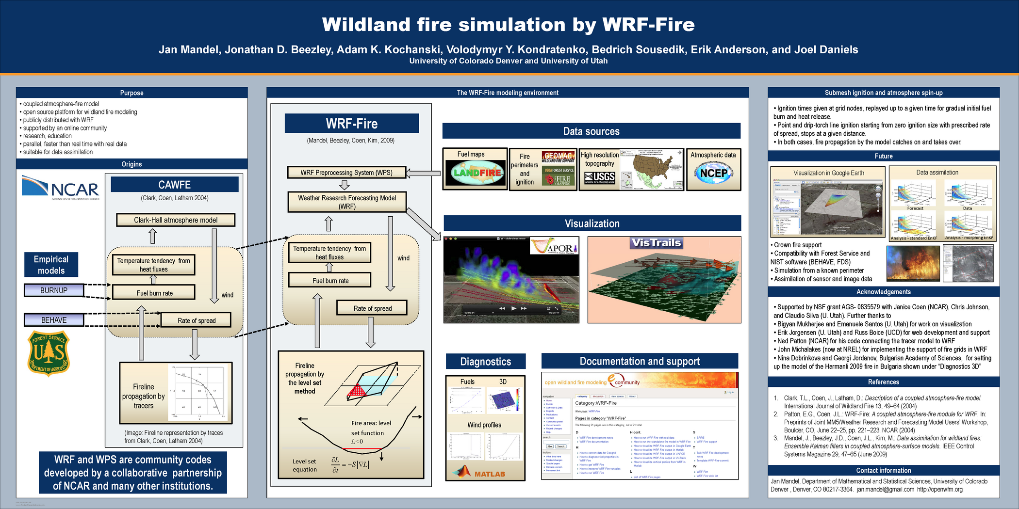
The code combines the Weather Research and Forecasting Model (WRF) with the semi-empirical fire spread model Rothermel (1972), with the fire spread implemented by the level-set method. Alternatives to the Rothermel’s model are in progress. The model is able to run faster than real time on several hundred cores, with the fire model resolution of few meters and horizontal atmospheric resolution on the order of 100m, for a large real fire Jordanov et al. (2011).
Kochanski et al. (2010) compared simulation results with measurements on the FireFlux grass fire experiment Clements et al. (2007). Dobrinkova et al. (2011) simulated a fire in Bulgarian mountains using real meteorological and geographical data, and ideal fuel data. Beezley et al. (2010) simulated a fire in Colorado mountains using real data from online sources. Jordanov et al. (2011) simulated a large fire in Bulgaria with real data, including a fuel map derived from satellite mesurements, and compared the results with the actual fire area.
2.2 Related work
Wildland fire models range from tools based based on fire spread rate formulas Rothermel (1972, 1983), such as BehavePlus Andrews (2007) and FARSITE Finney (1998), suitable for operational forecasting, to sophisticated 3D computational fluid dynamics and combustion simulations suitable for research and reanalysis, such as FIRETEC Linn et al. (2002) and WFDS Mell et al. (2007). BehavePlus, the PC-based successor of the calculator-based BEHAVE, determines the fire spread rate at a single point from fuel and environmental data; FARSITE uses the fire spread rate to provide a 2D simulation on a PC; while FIRETEC and WFDS are physically more accurate and run much slower than real time.
The level set-method was used for a surface fire spread model in Mallet et al. (2009). Filippi et al. (2009) coupled the atmospheric model, Meso-nh, with fire propagation by tracers. Tiger Mazzoleni and Giannino (2010) uses a 2D combustion model based on reaction-convection-diffusion equations and a convection model to emulate the effect of the fire on the wind. FIRESTAR Morvan and Dupuy (2004) is a physically accurate wildland fire model in two dimensions, one horizontal and one vertical. UU LES-Fire Sun et al. (2009) couples the University of Utah’s Large Eddy Simulator with the tracer-based code from CAWFE. See the survey by Sullivan (2009) for a number of other models.
2.3 New features
Recent features of the code include interpolation from an ideal logarithmic wind profile for nonhomogeneous fuels Mandel et al. (2011a), important for simulation at a variety of scales, and ignition from a fire perimeter with an atmosphere and fire spin-up Kondratenko et al. (2011). The perimeter ignition is important for practical application and the technique will be adapted also for data asimilation, where the atmosphere state needs to be adjusted when the fire state changes due to new data.
New features which were added to the code since the paper Mandel et al. (2011a) include computation of fireline intensities. Byram’s fireline intensity Byram (1959) is the heat produced per unit length of the fireline in unit time (J/m/s) in the so-called flaming zone behind the fireline. Hence, it is given by
| (1) |
where (J/kg) is the heat contents of the fuel, (m/s) is the spread rate, and (kg/m2) is the fuel amount that burns in the flaming zone. In practice, the fuel amount burned is estimated as a fixed fraction of the fuel load (kg/m2).
Though Byram’s fireline intensity is routinely used for practical guidance, it does not depend on the speed of burning. However, if the fuel burns slowly, much of the burning takes place at a distance from the fireline and thus may not contribute much to the severity of the fire, while a fast burning fuel will release its heat close to the fireline.
For this reason, we introduce a new concept of fireline intensity as the amount of heat generated by the advancing fireline from the newly burning fuel only, in a small unit of time. Assume that the fuel fraction after ignition decreases exponentially with the time from ignition, as
where is the fuel burn time, i.e., the time when of fuel has burned. Straightforward application of calculus then shows that the new fireline intensity is
| (2) |
Unlike Byram’s fireline intensity (1), the new fireline intensity, given by (2), takes into account the effect that a faster burning fuel will create a more intense heat concentrated at the fireline. The reason why the time unit is squared is that over a longer time, the fireline advances over a longer distance, and the fuel it advances over also has longer to burn.
The code computes the fireline intensities and the reaction intensity (which is the same as the released heat flux intensity, J/s/m2) for the simulated fire to estimate its severity. The fireline intensities are computed from the fire rate of spread . Since is well-defined on the fireline only, the fireline intensities are defined on mesh nodes next to the fireline only as well.
Separate computations are made as a component of a fire danger rating to estimate the severity of a potential fire, that is, to answer the question: if a fire breaks out, how bad would it be? These quantities are computed from the maximal rate of spread at any location for the wind speed and the slope at that location, and they can be used to plot potential fire severity maps.
3 OpenWFM wiki

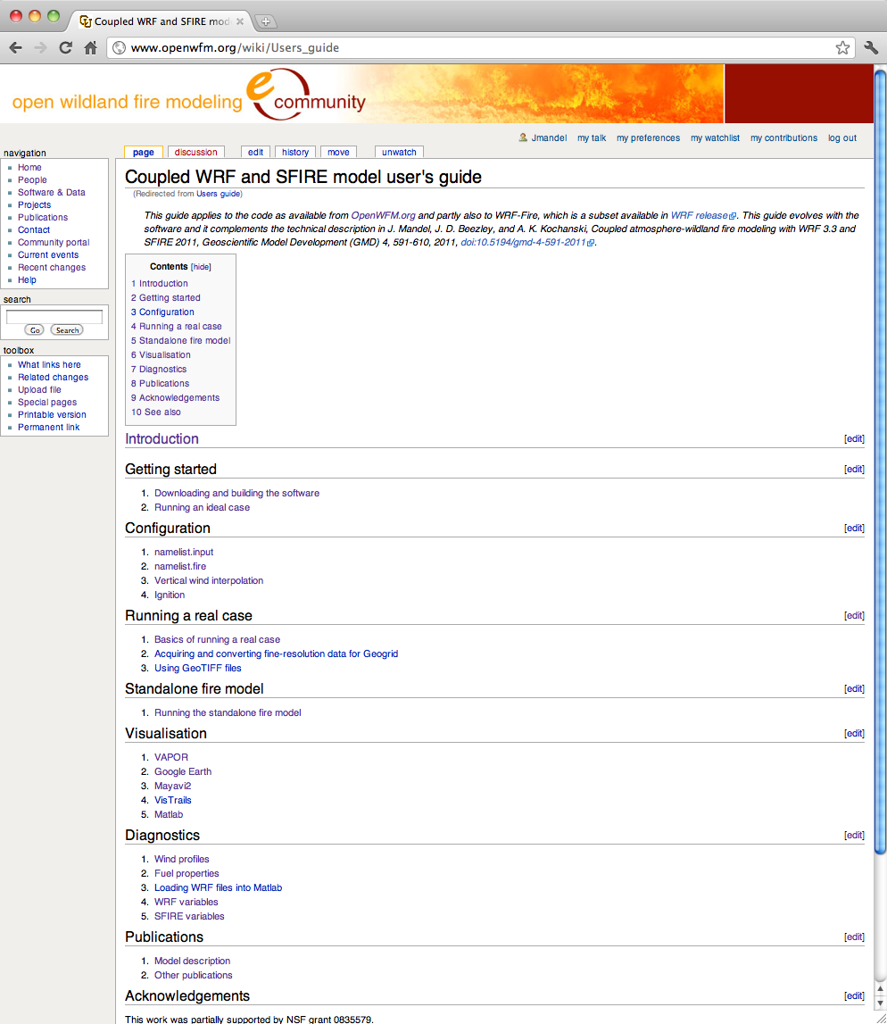
Fig. 2 shows the list of all wiki pages for the support of the simulation code. The pages starting with “How to” are short guides that allow the user do basic things simply. Users can then investigate variations at their leisure.
Diagnostic utilities, described in the wiki and available from source code repositories, allow the user, e.g., generate graphs of fire spread rate as a function of wind speed to aid in debugging fire properties, or draw wind profiles at a specified point (the wind speed as a function of height).
Since most the user’s guide (appendix in Wang et al. (2010)) was extracted from the wiki articles anyway, and the wiki has much more information, such as the diagnostic utilities, the existing wiki articles were now organized into a new, continously updated User’s Guide at http://www.openwfm.org/wiki/Users_guide (Fig. 3). This required adding only a minimal amount of material.
The OpenWFM wiki provides a social environment, where users can edit and comment on each other’s work. It is using the WikiMedia software.
4 Visualization, clients, web portals, and social networks
4.1 Google Maps and Google Earth
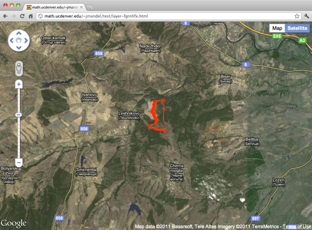


We have proposed Google Earth visualization already in Douglas et al. (2006). Since then, Google API has become a de-facto standard in wildland fire visualization. Both Google Earth and Google Maps use the same file format, KML (Keyhole Markup Language). We use the compressed format, KMZ. A KMZ file is a zipped directory with XML code containing drawing instructions and metadata, such as geolocation, and (optionally) image files to be displayed on the Earth surface. We use the image files to display the heat flux (Figs. 4 and 5) or fire area (Fig. 6). We render the file in Google Maps by posting it on the web and providing its URL to the Google Maps Javascript API, in a web page (Fig. 4), or loading the file into the Google Earth application. Google Earth can animate a KML file with multiple images as frames. Animation in Google Maps requires custom Javascript coding and is under development. Also, surface images to be visualized in Google Earth and Maps API use a different map projection than WRF, so the mesh nodes in WRF and the pixels in the image do not line up, and the simulation values need to be interpolated.
Future extensions include a web portal or a client application based on Google Maps, which can initiate a fire simulation on a cluster.
4.2 VisTrails and CrowdLabs

VisTrails (Freire et al. (2011), http://www.vistrails.org) is a scientific development environment for workflow and provenance management. It transparently stores user interactions within the system to ensure reproducibility of the produced data sets and visualizations. VisTrails provides a graphical programming interface that was specifically tailored for the generation of custom scientific visualizations. Through a drag-and-drop interface, users may interconnect modules that are responsible for reading a file, parsing the data, and performing different visualization tasks. VisMashups Santos et al. (2009) is a framework for the automatic development of simplified user interfaces from annotated workflows developed within the VisTrails environment.
Together, VisTrails and VisMashups, provide the tools to generate customizable visualizations for coupled WRF and fire simulations. Demonstrated in Fig. 7 is a fully interactive 3D visualization environment of the wildland fire simulation results, running locally on a user’s machine. These visualizations support exploration of the wildland fire through an interactive camera, toggles for the various ground and atmospheric variables, controls for isosurface and timing components, as well as interactive vector streamlines.

Providing web services, we improve the accessibility of the coupled WRF and fire simulation results for educational purposes and to improve communication and data sharing within the research community. We have setup the wildland fire simulation user group within CrowdLabs (Mates et al. (2011), http://www.crowdlabs.org). CrowdLabs is a social web site that provides a scalable environment for collaborative analysis involving simulation scientists, visualization experts, and other users alike. Through a web portal, users share and discuss VisTrails workflows and VisMashup interfaces to improve their efficacy. Fig. 8 illustrates the online interface for CrowdLabs, as well as a shared fire visualization on the site. It remains future work to provide 3D interactions within the web-based visualizations, as well as develop the controls to manage simulation executions from the site.
5 Acknowledgements
John Michalakes developed the support for the refined surface fire grid in WRF. The developers would like to thank Janice Coen for providing a copy of the Clark-Hall code with the tracer-based fire model, and Ned Patton for providing a copy of his prototype code linking a Fortran 90 port of the fire code with WRF. Eric Jorgensen has worked on setting up the OpenWFM.org site and the wiki. Barry Lynn and Guy Kelman have provided data in Israel and valuable operational considerations. Further contributions are acknowledged in the reference paper Mandel et al. (2011a).
References
- Andrews (2007) Andrews, P. L., 2007: BehavePlus fire modeling system: past, present, and future. Paper J2.1, 7th Symposium on Fire and Forest Meteorology, http://ams.confex.com/ams/pdfpapers/126669.pdf.
- Beezley (2011) Beezley, J. D., 2011: Importing high-resolution datasets into Geogrid. Paper P2, 12th WRF Users’ Workshop, National Center for Atmospheric Research, June 20-24, 2011, http://www.mmm.ucar.edu/wrf/users/workshops/WS2011/WorkshopPapers.php, visited August 2011.
- Beezley et al. (2010) Beezley, J. D., A. Kochanski, V. Y. Kondratenko, J. Mandel, and B. Sousedík, 2010: Simulation of the Meadow Creek fire using WRF-Fire. Poster at AGU Fall Meeting 2010, http://www.openwfm.org/wiki/File:Agu10_jb.pdf.
- Beezley et al. (2011) Beezley, J. D., A. K. Kochanski, V. Y. Kondratenko, and J. Mandel, 2011: Integrating high-resolution static data into WRF for real fire simulations. Paper 6.3, Ninth Symposium on Fire and Forest Meteorology, Palm Springs, October 2011, available at http://ams.confex.com/ams/9FIRE/webprogram/Paper192276.html.
- Byram (1959) Byram, G. M., 1959: Combustion of forest fuels. Forest Fire: Control and Use, K. P. Davis, ed., McGraw Hill, New York, 61–89.
- Clark et al. (2004) Clark, T. L., J. Coen, and D. Latham, 2004: Description of a coupled atmosphere-fire model. International Journal of Wildland Fire, 13, 49–64, doi:10.1071/WF03043.
- Clark et al. (1996a) Clark, T. L., M. A. Jenkins, J. Coen, and D. Packham, 1996a: A coupled atmospheric-fire model: Convective feedback on fire line dynamics. J. Appl. Meteor, 35, 875–901, doi:10.1175/1520-0450(1996)0350875:ACAMCF2.0.CO;2.
- Clark et al. (1996b) Clark, T. L., M. A. Jenkins, J. L. Coen, and D. R. Packham, 1996b: A coupled atmosphere-fire model: Role of the convective Froude number and dynamic fingering at the fireline. International Journal of Wildland Fire, 6, 177–190, doi:10.1071/WF9960177.
- Clements et al. (2007) Clements, C. B., S. Zhong, S. Goodrick, J. Li, B. E. Potter, X. Bian, W. E. Heilman, J. J. Charney, R. Perna, M. Jang, D. Lee, M. Patel, S. Street, and G. Aumann, 2007: Observing the dynamics of wildland grass fires – FireFlux – a field validation experiment. Bull. Amer. Meteorol. Soc., 88, 1369–1382, doi:10.1175/BAMS-88-9-1369.
- Coen (2005) Coen, J. L., 2005: Simulation of the Big Elk Fire using coupled atmosphere-fire modeling. International Journal of Wildland Fire, 14, 49–59, doi:10.1071/WF04047.
- Dobrinkova et al. (2011) Dobrinkova, N., G. Jordanov, and J. Mandel, 2011: WRF-Fire applied in Bulgaria. Numerical Methods and Applications, I. Dimov, S. Dimova, and N. Kolkovska, eds., Springer, Berlin/Heidelberg, volume 6046 of Lecture Notes in Computer Science, 133–140.
- Douglas et al. (2006) Douglas, C. C., J. D. Beezley, J. Coen, D. Li, W. Li, A. K. Mandel, J. Mandel, G. Qin, and A. Vodacek, 2006: Demonstrating the validity of a wildfire DDDAS. Computational Science ñ ICCS 2006: 6th International Conference, Reading, UK, May 28-31, 2006, Proceedings, Part III, V. N. Alexandrov, D. G. van Albada, P. M. A. Sloot, and J. Dongarra, eds., Springer, Berlin/Heidelberg, volume 3993 of Lecture Notes in Computer Science, 522–529.
- Filippi et al. (2009) Filippi, J. B., F. Bosseur, C. Mari, C. Lac, P. L. Moigne, B. Cuenot, D. Veynante, D. Cariolle, and J.-H. Balbi, 2009: Coupled atmosphere-wildland fire modelling. J. Adv. Model. Earth Syst., 1, Art. 11, doi:10.3894/JAMES.2009.1.11.
- Finney (1998) Finney, M. A., 1998: FARSITE: Fire area simulator-model development and evaluation. Res. Pap. RMRS-RP-4, Ogden, UT, USDA Forest Service, Rocky Mountain Research Station, http://www.fs.fed.us/rm/pubs/rmrs_rp004.html.
- Freire et al. (2011) Freire, J., D. Koop, E. Santos, C. Scheidegger, C. Silva, and H. T. Vo, 2011: VisTrails. Architecture of Open-Source Applications, A. Brown and G. Wilson, eds., Lulu.com, 377–394, available at http://www.aosabook.org.
- Jordanov et al. (2011) Jordanov, G., J. D. Beezley, N. Dobrinkova, A. K. Kochanski, and J. Mandel, 2011: Simulation of the 2009 Harmanli fire (Bulgaria). 8th International Conference on Large-Scale Scientific Computations, Sozopol, Bulgaria, June 6-10, 2011, Lecture notes in Computer Science, Springer, to appear. arXiv:1106.4736.
- Kochanski et al. (2010) Kochanski, A., M. Jenkins, S. K. Krueger, J. Mandel, J. D. Beezley, and C. B. Clements, 2010: Evaluation of the fire plume dynamics simulated by WRF-Fire. Presentation at AGU Fall Meeting 2010, available at http://www.openwfm.org/wiki/File:AGU.2010.kochanski.key.gz.
- Kondratenko et al. (2011) Kondratenko, V. Y., J. D. Beezley, A. K. Kochanski, and J. Mandel, 2011: Ignition from a fire perimeter in a WRF wildland fire model. Paper 9.6, 12th WRF Users’ Workshop, National Center for Atmospheric Research, June 20-24, 2011, http://www.mmm.ucar.edu/wrf/users/workshops/WS2011/WorkshopPapers.php, visited August 2011.
- Linn et al. (2002) Linn, R., J. Reisner, J. J. Colman, and J. Winterkamp, 2002: Studying wildfire behavior using FIRETEC. Int. J. of Wildland Fire, 11, 233–246, doi:10.1071/WF02007.
- Mallet et al. (2009) Mallet, V., D. E. Keyes, and F. E. Fendell, 2009: Modeling wildland fire propagation with level set methods. Computers & Mathematics with Applications, 57, 1089–1101, doi:10.1016/j.camwa.2008.10.089.
- Mandel et al. (2009) Mandel, J., J. D. Beezley, J. L. Coen, and M. Kim, 2009: Data assimilation for wildland fires: Ensemble Kalman filters in coupled atmosphere-surface models. IEEE Control Systems Magazine, 29, 47–65, doi:10.1109/MCS.2009.932224.
- Mandel et al. (2011a) Mandel, J., J. D. Beezley, and A. K. Kochanski, 2011a: Coupled atmosphere-wildland fire modeling with WRF 3.3 and SFIRE 2011. Geoscientific Model Development, 4, 591–610, doi:10.5194/gmd-4-591-2011.
- Mandel et al. (2011b) — 2011b: An overview of the coupled atmosphere-wildland fire model WRF-Fire. 91st American Meterological Society Annual Meeting, Seattle, WA, January 2011, http://ams.confex.com/ams/91Annual/webprogram/Paper185887.html.
- Mandel et al. (2010) Mandel, J., J. D. Beezley, A. K. Kochanski, V. Y. Kondratenko, B. Sousedík, E. Anderson, and J. Daniels, 2010: Wildland fire simulation by WRF-Fire. Poster at AGU Fall Meeting 2010, available at http://www.openwfm.org/wiki/File:Agu10_jm.pdf.
- Mates et al. (2011) Mates, P., E. Santos, J. Freire, and C. T. Silva, 2011: Crowdlabs: Social analysis and visualization for the sciences. Scientific and Statistical Database Management, J. Bayard Cushing, J. French, and S. Bowers, eds., Springer, BerlinHeidelberg, volume 6809 of Lecture Notes in Computer Science, 555–564.
- Mazzoleni and Giannino (2010) Mazzoleni, S. and F. Giannino, 2010: Tiger – 2d fire propagation simulator model. http://fireintuition.efi.int/products/tiger---2d-fire-propagation-simulator-model.fire, visited December 2010.
- Mell et al. (2007) Mell, W., M. A. Jenkins, J. Gould, and P. Cheney, 2007: A physics-based approach to modelling grassland fires. Intl. J. Wildland Fire, 16, 1–22, doi:10.1071/WF06002.
- Morvan and Dupuy (2004) Morvan, D. and J. L. Dupuy, 2004: Modeling the propagation of a wildfire through a Mediterranean shrub using a multiphase formulation. Combust. Flame, 138, 199–210, doi:10.1016/j.combustflame.2004.05.001.
- Rothermel (1972) Rothermel, R. C., 1972: A mathematical model for predicting fire spread in wildland fires. USDA Forest Service Research Paper INT-115, http://www.treesearch.fs.fed.us/pubs/32533.
- Rothermel (1983) — 1983: How to predict the spread and intensity of forest and range fires. U.S. Forest Service General Technical Report INT-143. Ogden, UT., http://www.treesearch.fs.fed.us/pubs/24635.
- Santos et al. (2009) Santos, E., L. Lins, J. Ahrens, J. Freire, and C. T. Silva, 2009: Vismashup: Streamlining the creation of custom visualization applications. Visualization and Computer Graphics, IEEE Transactions on, 15, 1539–1546, doi:10.1109/TVCG.2009.195.
- Sullivan (2009) Sullivan, A. L., 2009: A review of wildland fire spread modelling, 1990-present, 1: Physical and quasi-physical models, 2: Empirical and quasi-empirical models, 3: Mathematical analogues and simulation models. International Journal of Wildland Fire, 18, 1: 347–368, 2: 369–386, 3: 387–403, doi:10.1071/WF06143, 10.1071/WF06142, 10.1071/WF06144.
- Sun et al. (2009) Sun, R., S. K. Krueger, M. A. Jenkins, M. A. Zulauf, and J. J. Charney, 2009: The importance of fire-atmosphere coupling and boundary-layer turbulence to wildfire spread. International Journal of Wildland Fire, 18, 50–60, doi:10.1071/WF07072.
- Wang et al. (2010) Wang, W., C. Bruyère, M. Duda, J. Dudhia, D. Gill, H.-C. Lin, J. Michalakes, S. Rizvi, X. Zhang, J. D. Beezley, J. L. Coen, and J. Mandel, 2010: ARW version 3 modeling system user’s guide. Mesoscale & Miscroscale Meteorology Division, National Center for Atmospheric Research, http://www.mmm.ucar.edu/wrf/users/docs/user_guide_V3/ARWUsersGuideV3.pdf.