GeoP2P: An Adaptive Peer-to-Peer Overlay for Efficient Search and Update of Spatial Information
Abstract
This paper proposes a fully decentralized peer-to-peer overlay structure GeoP2P, to facilitate geographic location based search and retrieval of information. Certain limitations of centralized geographic indexes favor peer-to-peer organization of the information, which, in addition to avoiding performance bottleneck, allows autonomy over local information. Peer-to-peer systems for geographic or multidimensional range queries built on existing DHTs suffer from the inaccuracy in linearization of the multidimensional space. Other overlay structures that are based on hierarchical partitioning of the search space are not scalable because they use special super-peers to represent the nodes in the hierarchy. GeoP2P partitions the search space hierarchically, maintains the overlay structure and performs the routing without the need of any super-peers. Although similar fully-decentralized overlays have been previously proposed, they lack the ability to dynamically grow and retract the partition hierarchy when the number of peers change. GeoP2P provides such adaptive features with minimum perturbation of the system state. Such adaptation makes both the routing delay and the state size of each peer logarithmic to the total number of peers, irrespective of the size of the multidimensional space. Our analysis also reveals that the overlay structure and the routing algorithm are generic and independent of several aspects of the partitioning hierarchy, such as the geometric shape of the zones or the dimensionality of the search space.
1 Introduction
Location-based information search has become a very popular and useful service in recent years. Almost all major web search engines [1, 2] provide location-based search tools for finding businesses and services at or around any particular geographic location. Current implementations of these industrial search engines rely on centralized indexing schemes maintained with large deployment of computing and storage resources. Such centralized architecture creates performance bottleneck for frequently updated information, such as the number of patients currently waiting in a clinic, or real time information such as video streams from monitoring cameras, due to the huge aggregate volume of updates. Arrival or departure of local entities are not readily reflected in the centralized index either. More importantly, crawling, replicating and indexing of all the information by a single authority denies the autonomy of different entities over their local inforamtion. All these requirements demand a fully decentralized self-organizing architecture, also known as a peer-to-peer architecture, where each local entity (called peer) maintains its own local information and indexing is performed collaboratively without any centralized authority. Such architecture allows autonomy over local information, removes performance bottlenecks, distributes and balances operational load and avoids any single point of failure.
In essence, locality-based search is realized by range queries and nearest neighbor queries in the 2-dimensional metric space of the earth surface. Techniques for resolving range and nearest neighbor queries in multidimensional metric space have been extensively studied and are well understood for centralized databases [4]. With recent advances in peer-to-peer systems, several approaches have been proposed in the literature to accommodate such functionalities in distributed databases with peer-to-peer organization.
In the peer-to-peer literature, originated from the study of decentralized file-sharing systems, peers or Internet-connected end-hosts communicate through a self-organized network of acquaintances, called overlay network. In a class of overlay networks, called structured overlays, the overlay neighborhood follows a certain pattern to facilitate efficient routing of query and update messages to the responsible peers. Peers are usually assigned randomized unique numerical identifiers and the structure is defined over the identifier space which is one-dimensional in nature. They are also called distributed hash tables (DHT) for the hash-table-like put and get interface they provide. Like regular hash tables, DHTs are designed for storage and retrieval of a single data item at a time and it is hard, though not impossible, to accommodate complex queries such as range queries in such systems.
Nevertheless, there exist several systems that are built on top of DHTs to accommodate range queries, even for multi-dimensional data sets [23, 8, 20, 6]. Due to the one-dimensional nature of the identifier space upon which the overlay structure is built, it is relatively easier to resolve range queries over a one-dimensional object space, if objects are hashed into numerical keys in the same space as identifiers using a proximity-preserving hash function. A common approach for serving multi-dimensional range queries over the DHTs is to encode the coordinates in multi-dimensional space into one-dimensional keys, using space filling curves. However, all known space filling curves have the problem of translating points of close proximity in multi-dimensional space into relatively distant points in the single dimension. This makes accurate resolution of the range queries harder and inefficient.
It may be noted that DHTs work well for resolving range queries, if the overlay structure is based on the object space, instead of the randomly assigned identifier space. It is not usually practical to create a customized DHT for every possible multi-dimensional object space. However, the unique combination of widespread interest in location-based search and the geographic distribution of information providing peers, suggests the development of customized overlay structures based on the geographic neighborhood.
Indeed there have been several proposals for creating overlay structures based on geographic proximity of peers or proximity of geographic locations represented by peers [9, 22, 7, 15, 21, 10]. The common feature of all such proposals is that the 2-dimensional geographic space is hierarchically partitioned into zones and the overlay structure allows routing of the queries along the depth of the hierarchy. Such idea of hierarchical partitioning originated from the well-known indexing data structures for multi-dimensional data-sets such as R-tree [5], widely used in the realm of centralized databases. One common problem in most of the distributed implementations of hierarchical partitioning schemes is that they assign special roles to some peers to represent different levels of zones in the hierarchy. This results in peers representing higher level zones becoming bottlenecks for query routing and single points of failure.
In this paper, we propose a fully decentralized peer-to-peer overlay structure named GeoP2P with hierarchical partitioning of 2-dimensional geographic space, where the maintenance of the overlay structure and the routing of queries are performed without any special peers in the zones. In fact, a very similar fully decentralized overlay structure, named P2PR-tree [14] was described previously. One problem of P2PR-tree is that it does not properly accommodate dynamic formation and adjustment of partitions in the presence of large-scale peer joins and departures, or churn. The main contribution of this paper is to show how information about dynamically formed zone boundaries can be maintained without significant overhead, allowing growth and retraction of the zone-hierarchy following the growth and reduction in the number of peers. This allows us to keep both the query routing time and the size of the state information maintained at each peer, within an average logarithmic bound of the number of peers in the system, irrespective of the size of the 2-dimensional space. Our analysis also reveals that several aspects of the zoning hierarchy such as geometric shape of the zones or dimensionality of the space, have minimal or no impact on the overlay structure and routing algorithms. Moreover, we have defined detailed mechanism for maintaining the overlay structure in the presence of churn.
The rest of the paper is organized as follows. Section 2 defines the problem and clarifies our assumptions. Section 3 introduces the overlay structure of GeoP2P based on hierarchical space partitioning and specifies the data structure (routing table) maintained by each peer. Section 4 explains how messages are routed for different types of queries, using the overlay structure introduced before. Correctness and complexity of the routing algorithms are also analyzed in the same section. Section 5 describes how the overlay structure adapts to the peer dynamics. In particular, this section describes how a newly joining peer initializes its routing table (Section 5.1), how the zone hierarchy is grown and retracted with change in the number of peers (Section 5.2 and 5.3), and how the correctness of the routing table entries is maintained in presence of churn (Section 5.4). Finally, we conclude with a discussion of our contributions compared to existing works in Section 6.
2 System Model and Assumptions
The system consists of large number of peers, distributed across a 2-dimensional space with rectangular boundary. Each peer resides in and a point in the 2 dimensional space and responsible for providing information relevant to that point. A peer can be a data collection sensor such as a surveillance camera or a database regarding a particular object related to the point such as a hotel or gas station. The data stored in each peer is updated independently. Also, any peer can be interested in any region in the space and launch a query. The purpose of the overlay network is to route the query to all relevant peers.
Although the earth surface is not 2-dimensional or rectangular, it can be projected as a rectangular region in a 2D plane, albeit with some distortion. Each peer is assumed to know its coordinates in the 2D plane from some off-the-shelf method such as Global Positioning System (GPS). Note that although we restrict our discussion in 2-dimensional space, the the proposed scheme can be easily generalized for spaces with 3 or more dimensions. Also, application of the proposed scheme is not limited to geographical space, it can be used for location based searches in virtual worlds as well as for range queries over search spaces of multiple continuous attributes.
We assume that each peer is connected to the an underlying network such as Internet and can potentially communicate with any other peer in the system using transport protocols in the underlay, as long as address of the target peer in the underlay is known. We denote the address as network address. Peers can arbitrarily join and leave the system. Thus it is practically impossible for a peer to know the network address and Cartesian coordinate of all peers in the system to resolve the query locally. Hence, the geographic space is indexed and the query is resolved in a distributed manner. Two important design criteria of the system are (i) to avoid assigning any special role to any peer and (ii) to allow peers to arbitrarily join and leave the system with minimum perturbation in the system.
The focus of this paper is to design the overlay network that facilitates different location based queries. By ‘resolving queries’, we mean routing an application defined message to the peers responsible for taking action on and/or sending reply of the message. We leave the exact semantics of the message and response to the application and concentrate on the routing mechanism. Example message semantics could be sending some commands to the peers at particular location, sending some database queries to the peers in a location to retrieve some information regarding the location or asking for handles for accessing some resources in the peers in a location.
3 Overlay Structure
In this section we discuss the structure of the GeoP2P overlay network that routes the geographic queries to relevant peers.
3.1 Structured Zoning
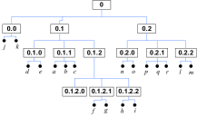
The universe is hierarchically divided into zones. At the top level of the hierarchy, the zone representing the universe is divided into a number of sub-zones, each of the sub-zones being further divided into sub-sub-zones at the next level of the hierarchy, and so on. Thus the zones can be conceptually organized into a tree, where the root of the tree represents the universe and each tree-node represents a zone. The zone represented by a tree-node completely contains all the sub-zones represented by the children of that node and the zones represented by the children completely cover the zone represented by the parent tree-node. Also, a zone is always divided into non-overlapping sub-zones. The leaf nodes of the tree represent the zones that are not divided any further, which we denote as leaf zones. Each peer belongs to a leaf zone at its deepest level, to successively larger zones at higher levels, and to the zone covering the universe at the top level. Figure 1(a) illustrates an example division of the universe and the corresponding tree representation is shown in Figure 1(b).


The division is performed dynamically according to the number and geographic distribution of the peers. The number of divisions and number of hierarchical levels of divisions may grow or shrink as peers join or depart from the system. The division of a zone into sub-zones is motivated by the number of peers in the zone and not by the area covered. Thus, after division, each of the sub-zones contains roughly an equal number of peers, but the amount of area covered by different sub-zones may vary widely. The maximum out-degree of the zoning hierarchy, i.e. maximum number of sub-zones under a zone is limited by a system-defined constant . The number of peers in each leaf zone is maintained roughly uniformly across the universe and kept within two system-defined thresholds – a higher threshold and a lower threshold . Division of a zone into sub-zones is triggered when the number of peers in the zone is above . A leaf zone may merge with one of its sibling zones if the number of peers in the zone goes below . Here, two different thresholds are used for triggering split and merge actions, following the standard practice of introducing a hysteresis loop in on-off feedback control systems. This helps avoiding oscillations between split and merge during peer join and departure, or churn. In fact, depending on the zoning scheme, a certain ratio of to need to be maintained, as described later in this section. Further details on the thresholds of split and merge can be found in [11].
Division of a zone into sub-zones can be performed in two different ways – i) splitting or ii) clustering. The choice of the zoning scheme is a design parameter, and only one of the zoning scheme is followed while constructing an overlay. In the splitting scheme, a rectangular zone is divided into rectangular sub-zones as shown in Figure 1(c). Division is always performed along the longer dimension of the rectangle, breaking the tie in favor of -axis. In the clustering scheme, non-overlapping rectangular areas within the zone are determined using a clustering algorithm, such that the number of peers in each rectangle is between and (Figure 1(a)). Each of the rectangular clusters is considered a sub-zone. The remaining non-rectangular area, which also contains some peers that are scattered and do not belong to any of the clusters, is considered as a sub-zone too. We denote the non-rectangular sub-zone as remainder zone. Note that a remainder zone always remains as a leaf zone.
In both of the zoning schemes, it is possible to divide a zone into sub-zones at a time or to offshoot one sibling at a time until the total number of siblings at that level reaches . For -at-a-time division, which we denote as complete division, needs to be at least times of , allowing a wide variation in the number of peers per leaf zone. The other scheme, denoted as incremental divisioning, does not require this and is more flexible in the sense that a zone can be divided into any number of sub-zones between and , depending on the availability and spatial distribution of peers. This is more suitable for the clustering zoning scheme, where spatial distribution of peers may not be suitable for making rectangular clusters. Incremental division, however, requires some additional messages to perform the division, as explained in Section 5.2.
Regardless of the choice of any particular zoning scheme, zones and peers may be identified using a structured naming system. Strictly speaking, naming of the zones or peers is not necessary for construction or evolution of the overlay structure, or for the purpose of routing messages. Such additional information may however be used for convenience and may serve as a tool for overlay maintenance, as described in Section 5.4. The name would identify the path in the zoning hierarchy from the root to the tree-node denoting a zone or peer. Such a name can be represented by a string of integers, which can be conveniently packed in a bit-string of sufficient length.
3.2 Routing Table
Each peer maintains a routing table that lists all the other peers it knows. To resolve a query about any region in the universe, a peer tries to find a peer that belongs to the leaf zones intersecting the query region. To do that, each peer needs to have some structured knowledge to cover the globe, such that for any zone, it either knows all the peers belonging to that zone, or at least knows some peer that knows more about that zone. Any query can thus be either resolved or forwarded to a peer that has better knowledge of the queried region.


One way to cover the globe with minimum amount of knowledge is that, for each level, a peer knows at least one peer in all the sibling zones, except its own zone for that level. At the deepest level, the peer knows all other peers within its own leaf zone. So, if a peer belongs to a level leaf zone, its routing table contains contact peers, where is the maximum number of divisions of a zone at any particular level. Assuming the tree of divisioning to be balanced, , where is the total number of peers in the overlay. We will demonstrate later that it is not expensive to maintain this information correctly in presence of peer join and departure.
The routing table is organized in rows, one for each level of hierarchy from to . Each row maintains information regarding sibling zones of that level, plus some information for the self-zone. For each sibling zone, the table need to maintain the network address of one (or more) contact peer, rectangular boundary (coordinates of bottom-left and top-right corner) of the zone. Siblings can be organized into columns based on the segment of the zone id that identifies the branching at that level. For the self-zone, only the zone boundary need to be maintained, and it can be stored in the corresponding column based the id of the self-zone. Level , stores the information regarding the leaf zone and here the siblings are individual peers instead of zones. So, coordinates of the peers are stored here instead of rectangular boundaries. Figure 2(b) shows an example routing table of a peer. The same overlay neighborhood is illustrated in Figure 2(a)
In Section 5.2 and 5.3, we explain how the boundary information can be retained when the network grows or shrinks due to peer join and departure.
In a sense, the structure of the routing table in GeoP2P is very similar to many other distributed hash tables (DHTs) such as Pastry [18] and Kademlia [13], that use Plaxton’s prefix matching based routing [16]. We may think that at each digit in the numerical identifier used in those DHTs, from the most significant towards the least significant, the identifier space is hierarchically divided into sub-regions, and each node belongs to a region of the identifier space at the deepest level of hierarchy. In that sense, the routing table of a peer in those DHTs also maintains pointers to at least one peer in all other sibling sub-regions at each level of the hierarchy. In fact, when zones are identified by numbers, the same prefix-based routing works here too. The difference between those DHTs and GeoP2P is that in our case we have zoned the geographic space instead of the identifier space, and also our zoning is dynamic instead of being pre-configured.
4 Routing Messages
As discussed in Section 2, the main purpose of the GeoP2P overlay is to route messages targeted to peers in a particular geographic location. Exact semantics of the message, which can be a query or an update of information or a command, is left to the application that uses the overlay. The job of the overlay is to route the application defined messages to the specified target peers and then deliver the message to the same application in the target. Some of these routing services are also used by some of the overlay management functions such as zone division or routing table update. The target of a message may be defined in several forms, e.g. all peers in a specified area (used for range query), at least one peer in a specified area or the peer closest to a specified point (used for nearest neighbor query). The following text explains the routing methods for different types of targets.
4.1 Messages Targeted to Peers in an Area
In this case a message is targeted to an area or range of interest, and we denote them as area messages. Such messages are used for querying information from peers in a particular area or for updating or commanding the peers in that area. We assume that the area of interest is specified by an axis-parallel rectangle, although it could be any 2-dimensional geometric shape. We chose axis-parallel rectangles, because our zoning scheme uses rectangular areas, and it is slightly easier to decide whether a rectangular zone in the overlay intersects with the area of interest. The message may be targeted to all peers or at least one peer in the specified area.
Algorithm 1 summarizes the protocol that a peer follows when it receives an area message targeted to all peers in the specified area. Each peer forwards the message to all sibling zones at all levels of the routing table, whose area intersects with the target area, and to all peers within the leaf level self-zone, which fall in the target area. While forwarding the message, the parameter is determined based on the row of the routing table in which the match is found. This is necessary to avoid reaching the same zone from different paths. Initially, the routing engine of the source peer receives the message with the parameter from the application. Figure 2(c) illustrates the routing path of a message targeted to all peers in a specified area (dotted rectangle). Theorem 1 summarizes the properties of the routing algorithm.
Theorem 1.
Algorithm 1 delivers an area message to all peers in the specified area and not to any other peer within a finite number of hops, as long as the routing tables are correct. In fact the number of hops is bounded by . Also each peer in the area receives the query exactly once (no redundant transmission).
Proof.
According to the construction, for each level of the zoning hierarchy, the routing table of a peer maintains contact of at least one peer for each of the level sibling zones the peer does not belong to, under the peer’s own level zone. So, if the target area does not intersect the zone of the current peer at level , it can always travel to the matching level zones. If it matches the zone of the current peer at level , level zones within this level zones are searched for match. Thus the target area is progressively resolved towards finer grain matching zones and the message is not forwarded to any zone that does not intersect the target area. The target area is resolved downwards for at least one level of hierarchy at each hop, and it never travels to zones at equal or higher level of hierarchy that have already been resolved. So the resolution terminates after hops, where is the maximum depth of the zoning hierarchy. According to the zone construction, . Since only one copy of the message flows through each unique path of the hierarchy, the message is delivered to relevant peers exactly once. ∎
One may note that Algorithm 1 can easily accommodate area definitions of any 2-dimensional geometric shape other than axis-parallel rectangles, as long as the shape meets two criteria – (i) the shape can be concisely represented in the message and (ii) there is a computationally efficient local algorithm to decide whether a rectangular zone intersects (needed in Line 13) or a point falls in the specified region (needed in Line 6). For example, a circular shape meets both the criteria. It can be represented with the center and the radius parameters, and it is not computationally hard to decide the intersection and the falls-in conditions. Moreover, messages with a circular target area are useful, e.g. to find a peer within certain distance or to find the nearest peer (Section 4.2). In fact, following the same argument, the zoning hierarchy itself can be defined based on zones of any shape other than rectangles.
When the message is , which is destined for any peer in the area, instead of all peers, Algorithm 1 can be applied with simple modifications. The procedure terminates after Line 2 if the current peer is a matching peer. The loop in Lines 5- 9 terminates as soon as a matching peer is found. The rest of the algorithm remains the same.
A special variant of area message is a message with a target area defined by a zone in the zoning hierarchy. Such zone broadcasting is used by some of the overlay management operations described in Section 5. Although the same Algorithm 1 can be used for this purpose, for efficiency it may be implemented by avoiding the area intersection conditions. Algorithm 2 summarizes the modified protocol to forward a message targeted to all peers within the level self-zone of the peer.
4.2 Message Targeted towards a Point
Messages whose target is defined by a point, denoted as point message, may have several types of targets which are useful for different purposes. One possible target is a peer closest to the specified point. Another target of interest would be all or any peer in a leaf zone where the specified point falls in. Because it matches with the overlay structure, routing to peers in the same leaf zone of the target point is easier than routing to nearest peer. This message is useful when a new peer wants to join the overlay. It can be routed in almost the same way as the area message is routed using Algorithm 1. Only the loop in Lines 11-17 terminates as soon as one matching zone is found, because a point cannot intersect more than one zones. In case any one peer is sought instead of all peers in the leaf zone, the loop in Lines 5-9 terminates as soon as one matching peer is found.
Routing a message to the nearest peer is little bit more complex than routing to any peer in the same leaf-zone of the point, because, the nearest peer may not reside in the same leaf zone. Routing of this message is done in two steps. First, using the same technique as described in previous paragraph, the message can reach at least one peer in the leaf zone that contains the specified point. Since this peer knows coordinates of all the peers in the leaf zone, it can determine the in-zone candidate peer that is closest to target point. To determine if any other peer exist in the universe which is closer to the target point, the current peer performs a range search in the circular area centered at the taget point and radius equal to the distance of the in-zone closest peer from the point. Such search is performed by sending an area-taregetd query message asking the peers to respond with their coordinates and network addresses. After receiving the response, the current peer can determine the peer closest from the taeget point in the universe, and forward the message to that peer for delivery.
5 Maintaining the Overlay Strucutre with Peer Dynamics
5.1 Peer Join and Routing Table Creation
When a new peer wishes to join the overlay it needs to initialize its routing table to get connected. We assume that before joining the overlay, the new peer knows its own network address and coordinate, and the network address of some peer already participating in the overlay. First, the new peer needs to find the leaf zone where its coordinate belongs to. To do this, the new peer sends a join message targeted to any peer in the leaf zone that contains its coordinate (Section 4.2). The peer that receives the join message informs all other peers in the same leaf zone of the existence of the new peer. It also replies back to the new peer with a copy of its own routing table. This table is a valid routing table for the new peer, except for adding the peer that replied the join message, in the leaf zone.
After copying the routing table in the way described above, the new peer is able to both route and receive messages. However, for the purposes of both reliability and load balancing, it is important to have diversity in the routing tables among the peers in the same zone. To achieve this, the new peer asks each peer in its routing table except those in the last row (peers in the same leaf zone), to send back copies of their routing tables. Say is the routing table sent back by the contact peer at row and column of the initial routing table. Any entry of found in any row greater than is a valid entry for the row , column of the routing table of the new peer. A random sample of these entries may be used by the new peer. In fact, to reduce message size, random sampling is performed at the contact peer, with the row and sample size being specified when the sample is sought.
Is the existence of the new peer known to the rest of the universe? Right after join, all the peers in the same leaf zone stores the address and coordinate of the new peer in their last row of the routing table. Also, when the new peer contacts other peers for diversification of its routing table, those peers also become aware of the new arrival. They actually store the address of the new peer in their routing table, because the routing table entries may be refreshed whenever a message is received, as described later in Section 5.4. The new peer will eventually be known to the remainder of the universe too, either due to the application messages it will generate or due to the periodic refresh performed by every peer.
5.2 Network Growth and Zone Creation
As mentioned before, an leaf zone is divided into sub-zones, when the number of peers in the leaf zone grows above the higher threshold . The task of dividing a leaf zone can be performed by any peer within the zone. According to the construction of the routing table, each peer in the zone is aware of the zone-boundary before the division. Each peer is also aware of the coordinates and network addresses of all other peers inside the leaf zone, as well as the total number of peers in the zone. Since any peers would follow the same zoning algorithm using the same input information, they would result in the same zone division. However, to avoid any inconsistency due to network dynamics during the time when divisioning is done, the operation is performed by exactly one of the peers in the zone. To ensure this, the peer that first detects the necessity of dividing a leaf zone, invokes a simple one-round leader election protocol among all the peers within the zone, where the tie is broken in favor of higher numerical value of the network address. After performing the division, the leader communicates the new sub-zone boundaries to all peers within the zone before division. Each peer can now decide which of the sub-zones it belong to, based on the sub-zone boundaries and its own coordinate.
Each peer updates its routing table based on the new information. After division of a level zone into sub-zones of level , each peer needs to update its routing table entries for level and . The new level- entries will be a subset of the previous level- entries, pointing to only those peers that are located within the same level- zone. entries from the remainder of the previous level- entries will fill the level of the new routing table. Because the boundaries of the other level- zones are known, the peer can randomly choose one of the previously known peers for each of these zones. In addition, zone boundaries of those zones are stored in these entries, instead of the point coordinates previously stored. The remaining entries in the routing table can be discarded, or, for reliability purpose, can be stored as backup entries, as discussed later in Section 5.4.
From the procedure discussed above, it is obvious that the routing tables of all the peers can be updated very easily in only one round of message exchange, transmitting only messages at most. The content of the messages is also very small, only the boundaries of the newly formed zones need to be communicated. The routing table of only those peers that belong to the divided zone need to be updated, the maximum number of which is . Peers outside the zone are not affected. The computation done at each peer is also very simple and perturbs only the last two rows of the routing table. To minimize alteration of the routing tables, zone boundaries are not modified once zones are created. The only permitted ways to adjust the number of peers in a zone are dividing into sub-zones or merging with sibling zones (as discussed below).
5.3 Peer Departure and Network Retraction
Besides growing due to newly joining peers, the overlay may also shrink in size due to departure of peers. It is useful to contract the zoning tree along with this shrinkage of the network, so that the number of routing table entries are reduced accordingly. Reducing the depth of the zoning tree also reduces the number of overlay hops needed for message routing. One way of contracting the zoning tree is to merge a leaf zone that has very low number of peers with some other zone.
Merger may be triggered when the total number of peers in a leaf zone goes below the lower threshold . The question is with which zone to merge. Because the peers in the merging zone know about the boundary and at least one peer of each of the sibling zones, those zones become natural candidate for being merging partner. From the boundaries of all the siblings, one zone can be selected such that the resulting zone after merger will be a continuous rectangular region. This restriction may be relaxed, i.e. the merged zone need not be rectangular, in case a clustering zoning scheme is used and the merger is done with the remainder zone. We denote the zone that initiates the merger as merging zone and the zone that is chosen as merging partner as partner zone.
The merger is simple if the partner zone still is a leaf zone, i.e. no further split has occurred in it. Any peer in the merging zone may initiate the merger, we denote it as initiator. To avoid concurrent merger initiations, a the initiator performs leader election among the peers in the leaf zone, in the same way as done during zone divisions. Hereafter, we denote the winner of the election as initiator. The initiator knows at least one peer in the partner zone (denoted as partner peer). The partner peer knows all other peers in the partner zone. The initiator sends the merger request to the partner peer. The request contains the boundary of the merging zone and address and coordinates of all peers in that zone. On receiving the request, the partner peer realizes that it needs to extend the boundary of its own leaf zone and include the peers given in the message as neighbors. Say both the merging and the partner zones are at level of the hierarchy. So, the partner peer also need to update its level of its routing table, by removing the entry corresponding to the merging sibling.
Besides updating its own routing table, the partner peer also forwards the merger request to all other peers in its zone, so that all of them make the similar update in their routing tables. The initiator on the other hand, need to send a merger update message to each of the other siblings (except the merging partner) so that peers in them remove the merging zone from level of their routing tables. The initiator knows at least one peer in each sibling zone, so it can transmit the message to the known peer, which in turn can broadcast the message to all peers in its zone. Lastly, the partner peer need to respond to the initiator peer, with the address and coordinates of all other peers of the partner zone, so that all other peers in the merging zone can add them to their level entries in the routing table.
In case the partner zone is not a leaf zone, there need to be some additional steps of information propagation. The partner peer, on receiving the merger request from a level sibling, will realize that it no longer belongs to a leaf zone at level . It may belong to a leaf zone at level . It then broadcasts a zone-collapse request to all the peers in its own level- zone. After collapse is complete, the contact peer performs the rest of the merger procedure as described before.
The zone collapse request asks for collapsing all the zoning beyond level . On receiving the collapse request, each peer reply back with a collapse accept message. The reply message includes the network address and coordinates of all peers in the self leaf zone of the responding peer. The peer that requested the collapse, then aggregates the peer information and sends back that aggregated information to every responding peer with an announcement of the completion of the collapse.
Note that if the clustering zoning scheme is used instead of splitting, then the remainder zone will always be there as an leaf sibling zone at each level. Also the remainder zone does not need to remain rectangular and it can form a continuum with any of its siblings. So, in case of clustered zoning, merging is always done with the remainder zone. The routing table entry for the remainder zone is always maintained even if there is no peer to represent that zone.
5.4 Refreshing Routing Table Entries
As we described the routing table structure in Section 3.2, each peer maintains contact of at least one peer for all the sibling zones at each level of the zoning hierarchy. In presence of node join and departure, it is quite possible that the peer that was chosen as a representative contact during last update of the routing table is no longer there. So there is a need for continuous refreshing of the routing table entries, particularly of the representative contact peers. We avoid modification of the zone boundaries other than those during merger or division, so zone boundaries need not be refreshed continuously.
One way of refreshing the entries is to use the existing application traffic. If peer A forwards any message to peer B at level , B being an entry in level of A’s routing table, then peer A is also a valid entry for level in B’s routing table. To have peer A as a routing table entry, peer B needs three information – network address of A and the row and column of the routing table where A would fit in. We may assume that whenever a message is sent from a source to destination through the underlying network, the message is tagged with the source address, which is true for Internet protocol. Also, as we saw in the algorithms described in Section 4, every routed message has a level information, and this directly corresponds to the routing table row where the update will be done. To resolve the column, we need that a peer tags the message with its own zone id whenever it forwards a message. The segment of the zone-id that identifies the zone at level , corresponds to the column of the routing table entry to be updated. This in turn implies that, a peer does not need to tag messages with its fully-qualified zone-id, only the segment of the id that corresponds to the message level would suffice.
When storing some extra bits of information is not expensive, as is the case in present day desktop computers, a bucket of peer-addresses can be stored for each entry of the routing table for reliability purpose. The most recently seen peer in the bucket would be used for routing. To implement this policy, the peers in a bucket are maintained in an ordered list with most recently seen peer at the front. Whenever a new active peer is discovered, it is added in the front of the list and the peer at the tail is discarded in case of bucket overflow. Whenever an existing peer is found to be active, it is brought to the front. Similar techniques have been used by Kademlia DHT [13], which splits the id-space in a binary hierarchy.
One may note that the routing table updates using application messages is not sufficient to maintain the correctness of the routing table. Some peers may not generate or forward any message for a long period. Also, the knowledge of a peer-departure is not disseminated in this way. For this reason, each peer periodically refreshes its routing table by explicit message exchanges. The refresh mechanism maintains the invariant that at least one peer in each bucket is seen within the last units of time. To aid the implementation, the timestamp of the most recently seen peer is maintained for each bucket. This timestamp is checked for all the routing table entries at every units of time. If the elapse time from the timestamp is found to be more than for any entry, an explicit refresh is initiated for that.
To refresh an entry of row and column an echo message (ping) is sent to the most recently seen peer. If no response is found within a short timeout period, this is repeated for the subsequent peers in the bucket in order of recency, until one of them responded. The responding peer is moved to the front of the list and the timestamp of the bucket is updated.
In case no peer in the bucket responded, the most recently seen contacts of each of the sibling zones of row are asked to send its row column entry. If no new peer is discovered or no other sibling exist, each of the peer in the same leaf zone is requested for its routing table entry of row and column . If no new peer is discovered even in this phase, the zone corresponding to the routing table entry is considered out of contact until next refresh. In other cases, when some new peers are discovered, they are contacted sequentially to verify their liveness, until one of them responds. To maintain the routing table diversity, while contacting, the peer is also requested to send a random sample of its routing table entries of all rows higher than . The contacted peer uses only the most recently seen peer in each of its buckets in the sample. The refreshing peer stores the sample in its bucket after the responding peer. The timestamp is set to current time.
For the entries of the last row, which are peers within the same leaf zone, each bucket contains exactly one peer. Their existence is also verified by echo messages at every unit of time, excepting those which sent some message within last time units. The peers that did not respond to the echo within the short timeout period, are considered to have departed. This allows detection of peer departure within the same leaf zone. The knowledge of peer departure is eventually spread to the rest of the world, due to the refresh mechanism. Also, when one peer departs gracefully without crashing, it may inform all its contacts in the routing table.
The message overhead of the explicit refresh mechanism is proportional to the bucket size and inversely proportional to the refresh period, both of which are system design parameters. Appropriate bucket size and period may be determined empirically, based on the typical messaging frequency, message source distribution and reliability requirement of a particular application.
6 Discussion
In this section we explain the distinct features of the overlay structure and indexing scheme of GeoP2P compared to other known schemes designed and used for similar purposes.
6.1 Adaptive Hierarchical Zoning with Super-nodes
The purpose of our work was to design a fully decentralized peer-to-peer system based on hierarchical space partitioning, that would not rely on super-peers for supporting the area hierarchy, as used in other overlays such as Globase [7] and EZSearch [22]. Globase uses the clustering based approach the zone hierarchy, which gives more flexibility of space partitioning when geographic distribution of peers is non-uniform. However, Globase assigns nodes in the area hierarchy to special super-peers, which makes it less scalable. Because, the super-peers supporting the area nodes near the top of the area hierarchy may get overloaded from handling search queries. Also, failure of higher level super peers may result in large scale network partitioning. For these reasons, explicit reliability and load balancing techniques e.g. back-up super-peers become necessary in such systems.
6.2 P2PRTree: Hierarchical Zoning without Super-node
P2PR-tree [14] is another hierarchical space portioning based peer-to-peer overlay that does not rely on any special nodes. However, it assumes a special kind of area hierarchy: the first two levels of the hierarchy are defined in the form of an R-tree by a pre-defined static grid; the lower levels of the hierarchy are dynamically grown depending on the number of peers that will enter into the different sub-areas. For this dynamic part of the tree, a kind of clustering approach is chosen. However, the paper remains vague about the question how a new peer not falling into one of the clustered sub-areas is integrated into the tree. Also the possibility of loosing peers and the possible retraction of the area hierarchy is not considered in that paper.
6.3 Systems using Space Filling Curves and Common DHTs
There is another class of indexing systems that are built over existing DHT overlays to serve range queries in multidimensional object space [23, 8, 20, 6, 17, 3, 19]. A common feature of all these systems is that they leverage the use of existing well-known DHT overlay structures. In DHTs, peers are named using identifiers randomly chosen from a linear or one-dimensional numeric space and the overlay structure is based on the numeric proximities of these identifiers. Such structure allows range searches in one-dimensional space. What all the abovementioned systems commonly do is that they translate a range (or a point) in the multidimensional object space into one dimensional numeric space using a space filling curve (SFC).
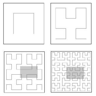
One major problem in this translation is that a contiguous range in multi-dimensional space does not translate into a contiguous range in the SFC in most cases. To solve this problem, the hierarchical property of the SFC is exploited. SFC maps the multi-dimentional universe by mapping its different segments in gradually finer granularities. If the universe is a -dimensional hypercube, it is divided into equal sized sub-cubes or cells. An approximation of SFC is obtained by joining the centers of these cells in a poly-line where each cell is connected to two adjacent cells. The part of the SFC representing each cell can be expanded further into a finer grain SFC. Thus after expansions up to depth , the resulting SFC contains segments, covering equal number of level- cells (Figure 3). Now, if the cells are identified using the distance along the SFC from its starting point in base- numbers, then the indentifiers that refer to the points in the same level cell have a common digit prefix [19]. DHTs allow looking up any one or all peers having certain identifier prefix. So, to route a query message to a multi-dimentional range target in DHT, the range is hierarchicaly translated into segments of the SFC, as the message is routed to the peers with prefix matching to the current segment.
In the abovementioned DHT based systems, the overlay structures are defined on identifier space. As the peer identifiers are assigned at random, the overlay neighborhood does not have any correlation with the physical proximity of the peers. This may be a rational choice when the overlay is to be used for search in different multidimensional object-spaces. We argued however that the geographic distribution of information providing peers and the uniquely high demand in location based search by many applications justify construction of a special purpose overlay for the 2-dimensional geographic search space. It would then be efficient, if the overlay neighborhood is chosen based on the geographic proximity of the peers. It is possible to map the geographic coordinate of the peers into numeric identifiers using a SFC and to construct a Pasrty-like DHT using the identifiers [12]. The resulting overlay structure would then be the same as GeoP2P overlay, if the hierachical zoning is performed along a static grid like the one used for hierarchical derivation of the SFC. In this sense, the GeoP2P overlay is a generalization of the SFC based overlay structure, where, instead of a fixed zoning scheme, zones of arbitrary size and shape can be created adaptively based on the geographic density of the peers.
Note that although the systems like PHT [17] or Squid [19] have been applied for range search in the 2-dimensional geographic space [3], their overlay structures are based on randomly assigned identifier space and thus have a fundamental difference with the overlay structure of GeoP2P. To perform 2-dimensional spatial search, they map the queried 2-d range into gradually fine grained segments of the SFC and look up the numeric keys resembling those SFC segments in the underlying DHT.
7 Summary
Although the peer-to-peer overlay structure and the decentralized spatial indexing scheme presented in this paper has many similarities with the other existing approaches, it contains several unique features. In summary, the main contributions made by this paper are the following:
First, we have described a generalized overlay structure based on hierarchical space partitioning, and demonstrated that certain aspects of the zone hierarchy have only minimal impact on the data structure and algorithms required for maintaining the overlay and routing different types of queries. In particular, the following aspects do not have any major effect on the structure and function of the overlay: (a) space partitioning scheme such as clustering or splitting, (b) dimensionality of the universe (c) geometry of the zones and the query region (circular or rectangular) and (d) peer representing a point or an area in the universe
Second, we have defined detailed algorithms for query routing. In addition to the standard range query routed to all peers associated with the search area, we have defined algorithms for routing messages to a single peer in the area, or to the peer that is closest to a given point in space.
Third, we have described detailed procedure for maintaining the virtual zoning hierarchy in the presence of churn. In addition to explaining how the virtual zoning hierarchy may grow when the number of peers in a given zone increases, we have also explained how the hierarchy may retract when the number of active peers decreases.
Although we allowed dynamic growth and retraction of the zone hierarchy in GeoP2P, we did not consider modifying the zone boundaries once a zone is created. Allowing such modifications will provide more flexibility in zoning when the spatial distribution of peers rapidly changes. In future we will study how to maintain the GeoP2P overlay structure in presence of such modifications without large scale propagation of information. Maintaining the overlay structure in presence of mobile peers is another related issue, which also remains to be considered in the future.
References
- [1] Google Maps. http://maps.google.com.
- [2] Yahoo Local. http://local.yahoo.com.
- [3] Y. Chawathe, S. Ramabhadran, S. Ratnasamy, A. LaMarca, S. Shenker, and J. Hellerstein. A Case Study in Building Layered DHT Applications. SIGCOMM Computer Communicaions Review, 35(4):97–108, 2005.
- [4] R. H. Güting. An Introduction to Spatial Database Systems. The VLDB Journal, 3(4):357–399, 1994.
- [5] A. Guttman. R-Trees: A Dynamic Index Structure for Spatial Searching. In SIGMOD’84, pages 47–57, Jun. 1984.
- [6] V. Kantere, S. Skiadopoulos, and T. Sellis. Storing and Indexing Spatial Data in P2P Systems. IEEE Trans. Knowledge and Data Engg., 21(2):287–300, 2009.
- [7] A. Kovacevic, N. Liebau, and R. Steinmetz. Globase.KOM - A P2P Overlay for Fully Retrievable Location-based Search. In IEEE International Conference on Peer-to-Peer Computing (P2P-2007), pages 87–96, Sep. 2007.
- [8] D. Li, X. Lu, B. Wang, J. Su, and J. C. Chan. Delay-Bounded Range Queries in DHT-based Peer-to-Peer Systems. In 26th IEEE International Conference on Distributed Computing Systems (ICDCS), page 64, Jul. 2006.
- [9] M. Li, W. Lee, and A. Sivasubramaniam. DPTree: A Balanced Tree Based Indexing Framework for Peer-to-Peer Systems. In 14th IEEE International conference on Network Protocols (ICNP), pages 12–21, Nov. 2006.
- [10] B. Liu, W. C. Lee, and D. L. Lee. Supporting Complex Multi-Dimensional Queries in P2P Systems. In 25th IEEE International Conference on Distributed Computing Systems (ICDCS), Jun. 2005.
- [11] T. Locher, S. Schmid, and R. Wattenhofer. equus: A provably robust and locality-aware peer-to-peer system. Sixth IEEE International Conference on Peer-to-Peer Computing (P2P’06), pages 3–11, Sep. 2006.
- [12] B. Maniymaran. Resource Addressable Network. PhD thesis, McGill University, Montreal, Canada, 2009.
- [13] P. Maymounkov and D. Mazières. Kademlia: A Peer-to-Peer Information System Based on the XOR Metric. In 1st International Workshop on Peer-to-Peer Systems (IPTPS), pages 53–65, Mar. 2002.
- [14] A. Mondal, Y. Lifu, and M. Kitsuregawa. P2PR-Tree: An R-Tree-Based Spatial Index for Peer-to-Peer Environments. In EDBT 2004 Workshops, pages 516–525, Mar. 2004.
- [15] B. Nam and A. Sussman. DiST: fully decentralized indexing for querying distributed multidimensional datasets. In 20th IEEE International Parallel and Distributed Processing Symposium (IPDPS), page 10, Apr. 2006.
- [16] C. Plaxton, R. Rajaraman, and A. Richa. Accessing Nearby Copies of Replicated Objects in a Distributed Environment. In 9th ACM Symp. on Parallel Algorithms and Architectures (SPAA), 1997.
- [17] S. Ramabhadran, S. Ratnasamy, J. M. Hellerstein, and S. Shenker. Brief announcement: Prefix hash tree. In The 23rd annual ACM symposium on Principles of Distributed Computing (PODC), pages 368–368, 2004.
- [18] A. Rowstron and P. Druschel. Pastry: Scalable, Decentralized Object Location, and Routing for Large-Scale Peer-to-Peer Systems. In IFIP/ACM Intl. Conf. on Distributed Systems Platforms, pages 329–350, 2001.
- [19] C. Schmidt and M. Parashar. Analysing the Search Characteristics of Space Filling Curve-Based Indexing withing Squid P2P Data Discovery System. Technical Report TR-276, Department of ECE, Rutgers University, Dec. 2004.
- [20] W. Song, R. Li, Z. Lu, and G. Yu. FAN: A Scalable Flabellate P2P Overlay Supporting Multi-Dimensional Attributes. In 22nd IEEE International Conference on Advanced Information Networking and Applications (AINA), pages 1005–1012, Mar. 2008.
- [21] E. Tanin, A. Harwood, and H. Samet. Using a Distributed Quadtree Index in Peer-to-peer Networks. The VLDB Journal, 16(2):165–178, 2007.
- [22] D. A. Tran and T. Nguyen. Hierarchical Multidimensional Search in Peer-to-peer Networks. Computer Communications, 31:346–357, 2008.
- [23] C. Zheng, G. Shen, S. Li, and S. Shenker. Distributed Segment Tree: Support of Range Query and Cover Query over DHT. In 5th International Workshop on Peer-to-Peer Systems (IPTPS), Feb. 2006.